The Norfolk archaeological trust welcomes you to Burgh Castle
5
Conservation work on the land at Burgh Castle owned by the Norfolk Archaeological Trust, and the construction of the new car park, have been generously funded by Natural England. H ERE AT BURGH CASTLE you can explore the best preserved Roman monument in East Anglia. In fact, this is one of the most impressive Roman buildings to survive anywhere in Britain. The site is owned and cared for by the Norfolk Archaeological Trust, with support from English Heritage. The Burgh Castle fort was probably called Gariannonum by the Romans. During its long history it has also been the site of a Norman castle and perhaps an early Christian monastery as well. Burgh Castle is rich in bird, animal and plant life. The fort stands within a natural environment which can teach us much about East Anglia’s constantly changing climate and coastline. The Roman fort This fort was one of a series of at least nine Roman coastal forts in eastern and southern England known as the Forts of the Saxon Shore. The earliest of these were built sometime after AD 200. The later Roman period in Britain was a turbulent time, when life in East Anglia was affected more and more by seaborne raiders from the Continent. The present defences at Burgh Castle date to around AD 300. Large parts of the fort’s walls still stand almost to their full height. No other Roman building in East Anglia has survived so well. The fort was probably also an important centre for trade in the later Roman period. It formed part of a network that included much of Europe, extending from Britain as far as Egypt, Palestine and Turkey in the east. This reminds us that Roman East Anglia was closely connected to a very much wider world, and was an important part of a great empire. An Anglo-Saxon monastery? After the Romans left Britain, the abandoned fort was reoccupied in the Anglo-Saxon period. Burgh Castle may have been the site of a monastery founded by Saint Fursey, a missionary from Ireland involved in converting East Anglia to Christianity. Timber buildings and burials excavated at the site may date to c. AD 700–900. The Norfolk archaeological trust welcomes you to Burgh Castle A Norman castle In the years after the Norman Conquest in 1066, a castle of earth and timber was built in one corner of the fort. This has been mostly flattened, but traces of the mound and ditch can still be seen. Conservation and wildlife The Trust works for total landscape conservation, balancing the needs of wildlife with its mission to conserve archaeological sites and open them up for the public to enjoy, free of charge. The site is an exceptional habitat for wildlife. Some of the bird, plant, insect and butterfly species, especially in the reed beds below the fort, are seldom seen elsewhere. An information panel on the viewing platform overlooking the reed beds identifies some of the animals, birds and insects that you might see during your visit. This air view was taken from the south. The Roman fort can be seen on the lower right-hand side of the picture. Most of the land visible in this picture was under deep water in Roman times. The harbour serving the fort was in the area of the light-coloured reed beds, in the centre of the picture. Mike Page The Burgh Castle property can be explored from a specially constructed all- weather footpath. Some gates on the site can be opened using RADAR keys for the benefit of visitors in wheelchairs. The Norfolk Archaeological Trust www.norfarchtrust.org.uk Some rare species of birds, plants and insects live at Burgh Castle. The Norfolk Archaeological Trust’s property here includes many different habitats, including meadow, woodland and reed bed. photograph – Peter Wade-Martins illustration – Julie A. Curl Bee Orchid Norfolk Hawker dragonfly The Norfolk Archaeological Trust owns 90 acres (37 hectares) of land at Burgh Castle. The archaeological remains extend far beyond the area of the fort. The Trust’s holding also includes much of the area of a large Roman civilian settlement (vicus) that lay outside the fort walls. Information: Norfolk Historic Environment Record THE NORFOLK ARCHAEOLOGICAL TRUST Interpretation and design by World Tree (www.world-tree.co.uk), 2011 The interpretation panels in the car park area and at the viewing platform overlooking the marshes have been funded by Natural England. The area of the Roman fort itself is in the guardianship of English Heritage, who have provided additional panels there.
Transcript of The Norfolk archaeological trust welcomes you to Burgh Castle

Conservation work on the land at Burgh Castle owned by the Norfolk Archaeological Trust, and the construction of the new car park, have been generously funded by Natural England.
HERE AT BURGH CASTLE you can explore the best preserved Roman monument in East Anglia. In fact, this is one of the most
impressive Roman buildings to survive anywhere in Britain. The site is owned and cared for by the Norfolk Archaeological Trust, with support from English Heritage.
The Burgh Castle fort was probably called Gariannonum by the Romans. During its long history it has also been the site of a Norman castle and perhaps an early Christian monastery as well.
Burgh Castle is rich in bird, animal and plant life. The fort stands within a natural environment which can teach us much about East Anglia’s constantly changing climate and coastline.
The Roman fort
This fort was one of a series of at least nine Roman coastal forts in eastern and southern England known as the Forts of the Saxon Shore. The earliest of these were built sometime after AD 200. The later Roman period in Britain was a turbulent time, when life in East Anglia was affected more and more by seaborne raiders from the Continent.
The present defences at Burgh Castle date to around AD 300. Large parts of the fort’s walls still stand almost to their full height. No other Roman building in East Anglia has survived so well.
The fort was probably also an important centre for trade in the later Roman period. It formed part of a network that included much of Europe, extending from Britain as far as Egypt, Palestine and Turkey in the east. This reminds us that Roman East Anglia was closely connected to a very much wider world, and was an important part of a great empire.
An Anglo-Saxon monastery?
After the Romans left Britain, the abandoned fort was reoccupied in the Anglo-Saxon period. Burgh Castle may have been the site of a monastery founded by Saint Fursey, a missionary from Ireland involved in converting East Anglia to Christianity. Timber buildings and burials excavated at the site may date to c. AD 700–900.
The Norfolk archaeological trust welcomes you to
Burgh Castle
A Norman castle
In the years after the Norman Conquest in 1066, a castle of earth and timber was built in one corner of the fort. This has been mostly flattened, but traces of the mound and ditch can still be seen.
Conservation and wildlife
The Trust works for total landscape conservation, balancing the needs of wildlife with its mission to conserve archaeological sites and open them up for the public to enjoy, free of charge.
The site is an exceptional habitat for wildlife. Some of the bird, plant, insect and butterfly species, especially in the reed beds below the fort, are seldom seen elsewhere. An information panel on the viewing platform overlooking the reed beds identifies some of the animals, birds and insects that you might see during your visit.
This air view was taken from the south. The Roman fort can be seen on the lower right-hand side of the picture. Most of the land visible in this picture was under deep water in Roman times. The harbour serving the fort was in the area of the light-coloured reed beds, in the centre of the picture. Mike Page
The Burgh Castle property can be explored from a specially constructed all-weather footpath. Some gates on the site can be opened using RADAR keys for the benefit of visitors in wheelchairs.
The Norfolk Archaeological Trust
www.norfarchtrust.org.uk
Some rare species of birds, plants and insects live at Burgh Castle. The Norfolk Archaeological Trust’s property here includes many different habitats, including meadow, woodland and reed bed.
photograph – Peter Wade-Martins
illustration – Julie A. Curl
Bee Orchid
Norfolk Hawker dragonfly
The Norfolk Archaeological Trust owns 90 acres (37 hectares) of land at Burgh Castle. The archaeological remains extend far beyond the area of the fort. The Trust’s holding also includes much of the area of a large Roman civilian settlement (vicus) that lay outside the fort walls. Information: Norfolk Historic Environment Record
THE NORFOLK ARCHAEOLOGICAL TRUSTInterpretation and design by World Tree (www.world-tree.co.uk), 2011
The interpretation panels in the car park area and at the viewing platform overlooking the marshes have been funded by Natural England. The area of the Roman fort itself is in the guardianship of English Heritage, who have provided additional panels there.

THE ROMAN FORT dominates the scene at Burgh Castle today. Its story is a fascinating one, and there is still much to learn about it.
But life here in Roman times was just one chapter in a much longer story which continues to the present day.
The Roman coastline
In Roman times, the shape of east Norfolk and Suffolk was very different from that of today. Sea levels were much higher. The marshlands of the Norfolk Broads were occupied by a great deep-water estuary. The rivers Yare, Waveney and Bure could be navigated far inland by large ships. A Roman lighthouse at Reedham may have helped sailors travel up the River Yare to the local capital at Caistor St Edmund, south of modern Norwich.
To the north and south of the mouth of the estuary lay the ‘islands’ of Flegg and Lothingland. Where the town of Great Yarmouth stands today there was no dry land at all. The fort at Burgh Castle now overlooks reed beds, but in Roman times it lay next to a sheltered harbour.
A fort of the Saxon Shore
The fort was built as part of a defensive network along Britain’s eastern and southern coasts. Burgh Castle is the best preserved Saxon Shore fort in Norfolk, although others are known at Caister-on-Sea and at Brancaster. The forts at Burgh Castle and at Caister probably worked as a pair, controlling the mouth of the Great Estuary.
The walls survive almost to their original full height, although a parapet (now missing) protected soldiers patrolling the wall top. The defences were strengthened by a series of projecting bastions, sited at the corners of the fort and at intervals along the walls. These huge ‘drums’ of masonry were added when the walls were half built. In the middle of the top of each bastion there is a hole in the masonry, which may have held the base of a platform or a large catapult.
The scene in Roman times was different in many ways. The west wall of the fort has vanished – probably it collapsed down the steep slope above which
Fort, Monastery and Castleit had been built. The walls were once faced everywhere in flint and tile. This has mostly been taken away to be used in other building work, except in parts of the south wall. We know little about the buildings that lay within these defences, because there has been little excavation. They could have been of timber or stone.
Civilian settlement
Air photographs and survey have shown that there was a large civilian trading settlement – or vicus – on the land to the east of the fort. This was built in timber and no longer survives, but would have dominated the landscape across which visitors walk to the fort today.
Saint Fursey
The Romans’ withdrawal in AD 410 was not the end of the story. Excavation has shown that the fort was occupied again during the Anglo-Saxon period. More than 160 burials were found along with evidence for timber buildings, one of them large. Perhaps this became the site of an early Christian monastery and cemetery.
The fort site has often been linked with Saint Fursey, who was given land around AD 630 to build a monastery at a place called Cnobheresburh. This may have been at Burgh Castle but we do not know for certain, and Fursey’s site may actually have been the nearby fort at Caister-on-Sea, where many Anglo-Saxon burials have also been found.
The Norman castle
After the Norman Conquest in 1066, much property was taken from its English owners and given to followers of William the Conqueror. Many of these barons built castles in their new lands. In the late eleventh or twelfth century a small castle was built in the southern part of the fort.
The castle mound or motte made use of part of the southern defences of the Roman fort and a big gap was cut through the south wall for the motte ditch. The castle mound was mostly flattened, and the surrounding ditch filled in, during the late eighteenth and early nineteenth centuries. However, its outline may still be seen at the southern end of the fort.
The south-eastern corner of the Roman fort defences, showing one of the bastions. The core of the wall is of flint and mortar. The outer face was surfaced in fine flint and tiles. Peter Wade-Martins
The Roman coastline of eastern Norfolk and Suffolk was different from today’s. Large ships could sail far inland and present-day Great Yarmouth did not exist at all.
This plan shows the layout of the site, the location of the Church of SS Peter and Paul, and the walking route for visitors. The church is also open to visitors free of charge. Information: East Anglian Archaeology; Norfolk Historic Environment RecordMany graves excavated within the fort date to the Anglo-Saxon period. These
skeletons were found during excavations inside the fort in 1958–61. Charles Green/Norwich Castle Museum & Art Gallery
This window from Burgh Castle church shows how Victorian people imagined Saint Fursey. Pilgrims honouring Fursey visit Burgh Castle today. Trevor Ashwin
THE NORFOLK ARCHAEOLOGICAL TRUSTInterpretation and design by World Tree (www.world-tree.co.uk), 2011
The Norfolk Archaeological Trust
www.norfarchtrust.org.uk
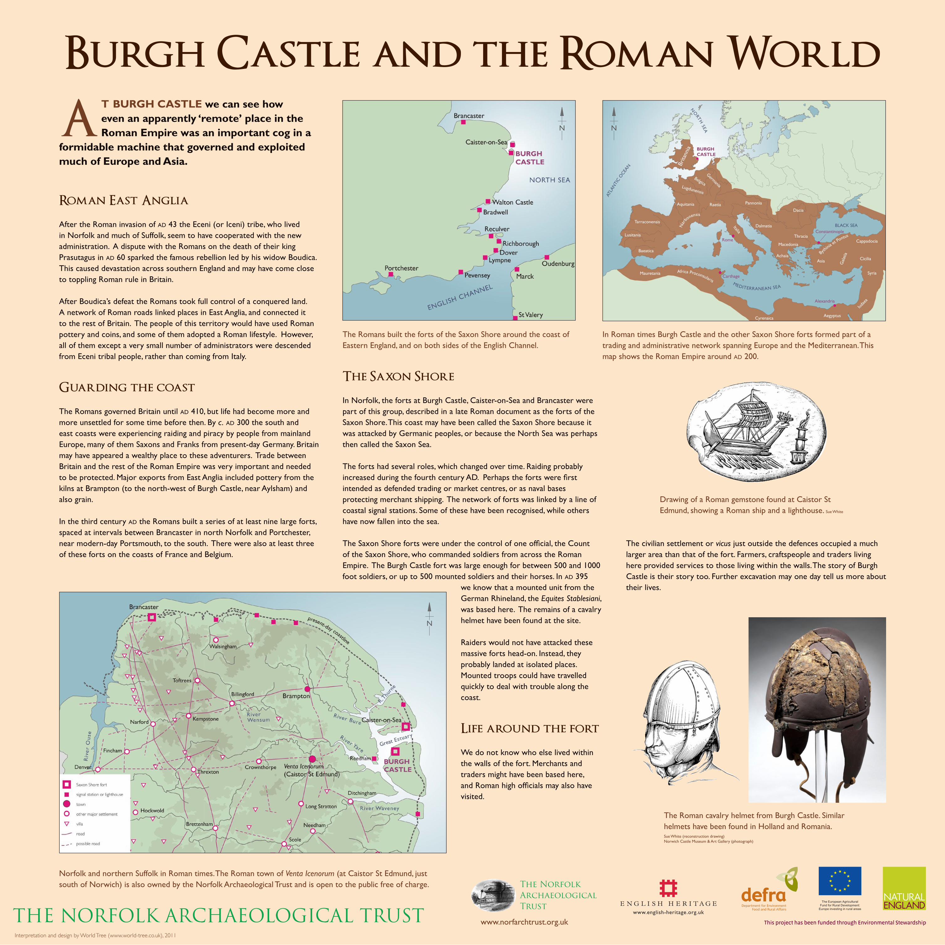
AT BURGH CASTLE we can see how even an apparently ‘remote’ place in the Roman Empire was an important cog in a
formidable machine that governed and exploited much of Europe and Asia.
Roman East Anglia
After the Roman invasion of AD 43 the Eceni (or Iceni) tribe, who lived in Norfolk and much of Suffolk, seem to have cooperated with the new administration. A dispute with the Romans on the death of their king Prasutagus in AD 60 sparked the famous rebellion led by his widow Boudica. This caused devastation across southern England and may have come close to toppling Roman rule in Britain.
After Boudica’s defeat the Romans took full control of a conquered land. A network of Roman roads linked places in East Anglia, and connected it to the rest of Britain. The people of this territory would have used Roman pottery and coins, and some of them adopted a Roman lifestyle. However, all of them except a very small number of administrators were descended from Eceni tribal people, rather than coming from Italy.
Guarding the coast
The Romans governed Britain until AD 410, but life had become more and more unsettled for some time before then. By c. AD 300 the south and east coasts were experiencing raiding and piracy by people from mainland Europe, many of them Saxons and Franks from present-day Germany. Britain may have appeared a wealthy place to these adventurers. Trade between Britain and the rest of the Roman Empire was very important and needed to be protected. Major exports from East Anglia included pottery from the kilns at Brampton (to the north-west of Burgh Castle, near Aylsham) and also grain.
In the third century AD the Romans built a series of at least nine large forts, spaced at intervals between Brancaster in north Norfolk and Portchester, near modern-day Portsmouth, to the south. There were also at least three of these forts on the coasts of France and Belgium.
The Saxon Shore
In Norfolk, the forts at Burgh Castle, Caister-on-Sea and Brancaster were part of this group, described in a late Roman document as the forts of the Saxon Shore. This coast may have been called the Saxon Shore because it was attacked by Germanic peoples, or because the North Sea was perhaps then called the Saxon Sea.
The forts had several roles, which changed over time. Raiding probably increased during the fourth century AD. Perhaps the forts were first intended as defended trading or market centres, or as naval bases protecting merchant shipping. The network of forts was linked by a line of coastal signal stations. Some of these have been recognised, while others have now fallen into the sea.
The Saxon Shore forts were under the control of one official, the Count of the Saxon Shore, who commanded soldiers from across the Roman Empire. The Burgh Castle fort was large enough for between 500 and 1000 foot soldiers, or up to 500 mounted soldiers and their horses. In AD 395
we know that a mounted unit from the German Rhineland, the Equites Stablesiani, was based here. The remains of a cavalry helmet have been found at the site.
Raiders would not have attacked these massive forts head-on. Instead, they probably landed at isolated places. Mounted troops could have travelled quickly to deal with trouble along the coast.
Life around the fort
We do not know who else lived within the walls of the fort. Merchants and traders might have been based here, and Roman high officials may also have visited.
The civilian settlement or vicus just outside the defences occupied a much larger area than that of the fort. Farmers, craftspeople and traders living here provided services to those living within the walls. The story of Burgh Castle is their story too. Further excavation may one day tell us more about their lives.
Burgh Castle and the Roman World
The Romans built the forts of the Saxon Shore around the coast of Eastern England, and on both sides of the English Channel.
Norfolk and northern Suffolk in Roman times. The Roman town of Venta Icenorum (at Caistor St Edmund, just south of Norwich) is also owned by the Norfolk Archaeological Trust and is open to the public free of charge.
In Roman times Burgh Castle and the other Saxon Shore forts formed part of a trading and administrative network spanning Europe and the Mediterranean. This map shows the Roman Empire around AD 200.
Drawing of a Roman gemstone found at Caistor St Edmund, showing a Roman ship and a lighthouse. Sue White
The Roman cavalry helmet from Burgh Castle. Similar helmets have been found in Holland and Romania.Sue White (reconstruction drawing) Norwich Castle Museum & Art Gallery (photograph)
THE NORFOLK ARCHAEOLOGICAL TRUSTInterpretation and design by World Tree (www.world-tree.co.uk), 2011
The Norfolk Archaeological Trust
www.norfarchtrust.org.uk
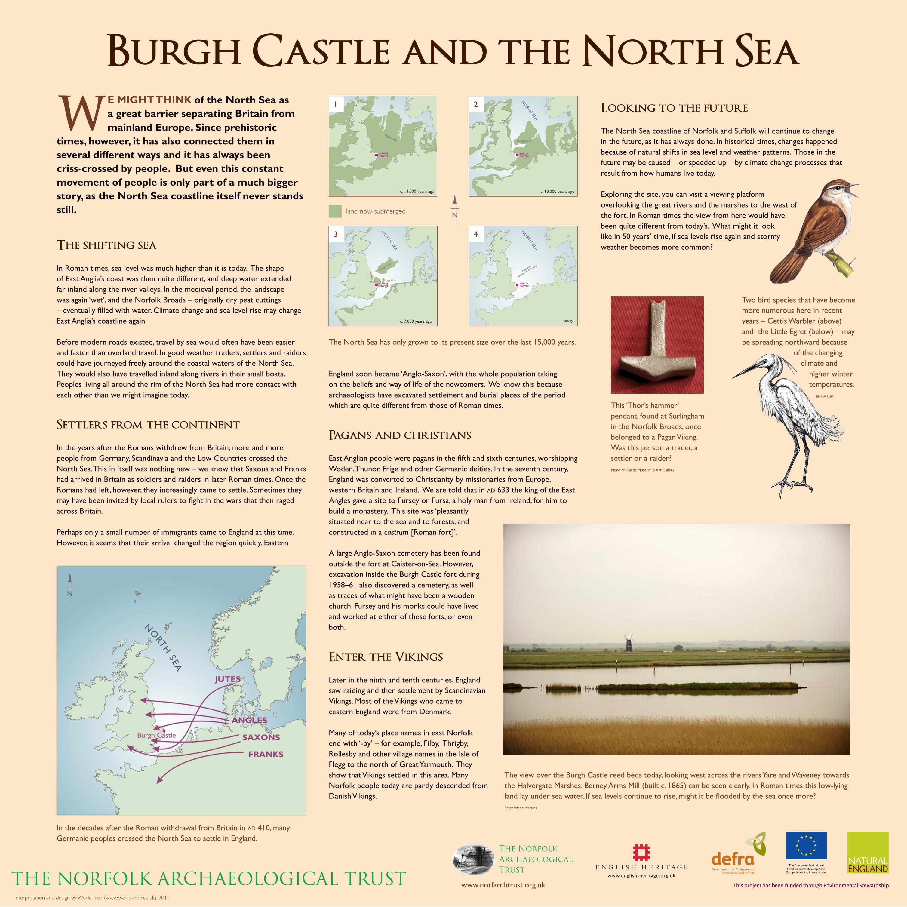
Burgh Castle and the North Sea
WE MIGHT THINK of the North Sea as a great barrier separating Britain from mainland Europe. Since prehistoric
times, however, it has also connected them in several different ways and it has always been criss-crossed by people. But even this constant movement of people is only part of a much bigger story, as the North Sea coastline itself never stands still.
The shifting sea
In Roman times, sea level was much higher than it is today. The shape of East Anglia’s coast was then quite different, and deep water extended far inland along the river valleys. In the medieval period, the landscape was again ‘wet’, and the Norfolk Broads – originally dry peat cuttings – eventually filled with water. Climate change and sea level rise may change East Anglia’s coastline again.
Before modern roads existed, travel by sea would often have been easier and faster than overland travel. In good weather traders, settlers and raiders could have journeyed freely around the coastal waters of the North Sea. They would also have travelled inland along rivers in their small boats. Peoples living all around the rim of the North Sea had more contact with each other than we might imagine today.
Settlers from the continent
In the years after the Romans withdrew from Britain, more and more people from Germany, Scandinavia and the Low Countries crossed the North Sea. This in itself was nothing new – we know that Saxons and Franks had arrived in Britain as soldiers and raiders in later Roman times. Once the Romans had left, however, they increasingly came to settle. Sometimes they may have been invited by local rulers to fight in the wars that then raged across Britain.
Perhaps only a small number of immigrants came to England at this time. However, it seems that their arrival changed the region quickly. Eastern
England soon became ‘Anglo-Saxon’, with the whole population taking on the beliefs and way of life of the newcomers. We know this because archaeologists have excavated settlement and burial places of the period which are quite different from those of Roman times.
Pagans and christians
East Anglian people were pagans in the fifth and sixth centuries, worshipping Woden, Thunor, Frige and other Germanic deities. In the seventh century, England was converted to Christianity by missionaries from Europe, western Britain and Ireland. We are told that in AD 633 the king of the East Angles gave a site to Fursey or Fursa, a holy man from Ireland, for him to build a monastery. This site was ‘pleasantly situated near to the sea and to forests, and constructed in a castrum [Roman fort]’.
A large Anglo-Saxon cemetery has been found outside the fort at Caister-on-Sea. However, excavation inside the Burgh Castle fort during 1958–61 also discovered a cemetery, as well as traces of what might have been a wooden church. Fursey and his monks could have lived and worked at either of these forts, or even both.
Enter the Vikings
Later, in the ninth and tenth centuries, England saw raiding and then settlement by Scandinavian Vikings. Most of the Vikings who came to eastern England were from Denmark.
Many of today’s place names in east Norfolk end with ‘-by’ – for example, Filby, Thrigby, Rollesby and other village names in the Isle of Flegg to the north of Great Yarmouth. They show that Vikings settled in this area. Many Norfolk people today are partly descended from Danish Vikings.
Looking to the future
The North Sea coastline of Norfolk and Suffolk will continue to change in the future, as it has always done. In historical times, changes happened because of natural shifts in sea level and weather patterns. Those in the future may be caused – or speeded up – by climate change processes that result from how humans live today.
Exploring the site, you can visit a viewing platform overlooking the great rivers and the marshes to the west of the fort. In Roman times the view from here would have been quite different from today’s. What might it look like in 50 years’ time, if sea levels rise again and stormy weather becomes more common?
In the decades after the Roman withdrawal from Britain in AD 410, many Germanic peoples crossed the North Sea to settle in England.
The view over the Burgh Castle reed beds today, looking west across the rivers Yare and Waveney towards the Halvergate Marshes. Berney Arms Mill (built c. 1865) can be seen clearly. In Roman times this low-lying land lay under sea water. If sea levels continue to rise, might it be flooded by the sea once more? Peter Wade-Martins
The North Sea has only grown to its present size over the last 15,000 years.
land now submerged
1 2
3 4
This ‘Thor’s hammer’ pendant, found at Surlingham in the Norfolk Broads, once belonged to a Pagan Viking. Was this person a trader, a settler or a raider? Norwich Castle Museum & Art Gallery
Two bird species that have become more numerous here in recent years – Cettis Warbler (above) and the Little Egret (below) – may be spreading northward because
of the changing climate and
higher winter temperatures.
Julie A Curl
THE NORFOLK ARCHAEOLOGICAL TRUSTInterpretation and design by World Tree (www.world-tree.co.uk), 2011
The Norfolk Archaeological Trust
www.norfarchtrust.org.uk

Berney Arms Mill
RIVER WAVENEY
CONFLUENCE OF THE RIVERS YARE
AND WAVENEYCantley sugar beet plant
Wickhampton churchRIVER YARE
(BERNEY ARMS REACH)
Burgh Castle reed beds
Cettis Warbler (Cettia cetti) – a brown warbler that resembles a small nightingale, but lacks the prominent rufous tail. Normally secretive, but will emerge from cover to deliver
a loud, explosive and repetitive song. This bird was once a summer visitor, but many are now year-round residents.
Norfolk Aeshna or Norfolk Hawker (Aeshna isosceles) – unique to Norfolk, this long dragonfly is yellow/brown in colour with a yellow triangle at the top of the abdomen.
Little Egret (Egretta garzetta) – white heron-like bird. With its black beak and legs and notable yellow feet, a striking and easily recognised
species. May be confused with the Spoonbill, which can also be seen here, but the Little Egret is smaller (55–65 cm) than the Spoonbill (80–90 cm). The Spoonbill also has a flattened end to the bill.
Marsh Harrier (Circus aeruginosus) – until recently one of our rarest birds, due to a combination of drainage, pesticides and
persecution. The size of a buzzard, reaching 20 inches/50cm. While the female is nesting the male can be seen hunting over marsh and field, calling her when food is ready. She will then rise in the air and turn upside down to take it from his talons.
Marsh Harrier – male (above) passing food to female
Comma (Polygonia c-album) – a butterfly commonly seen in the sunshine feeding on bramble, daisies and other plants. Ragged-edged appearance to the wings.
THE NORFOLK ARCHAEOLOGICAL TRUST’S property at Burgh Castle includes a number of Norfolk’s most important and sensitive wildlife
habitats. The illustrations on this panel show some of the species you might see or hear from this location during your visit.
The landscape around us here has changed constantly since prehistoric times. It will continue to change in future, and this will affect wildlife in many ways.
Short-eared Owl (Asio flammeus) – long narrow wings, buoyant flight and intense staring eyes that are surrounded
by a wide black outline of feathers within a pale facial disc. Flies during daylight hours over fields, sand
dunes and marshes, hunting for voles and small birds but occasionally taking other mammals.
Common Seal (Phoca vitulina) – reaches a length of up to 68 inches/173 cm (females are smaller). Rounded head and forward facing eyes – when in the water, their heads are often mistaken for buoys or fishing floats. The short muzzle and v-shaped nostrils help distinguish the Common from the Grey Seal.
Grey Seal (Halichoerus grypus) – can be 7 ft/c.2 m long. A long snout, a flat top to the head and
almost parallel nostrils. Much more vocal than the Common Seal, it
is known to bark, hiss, moan and snarl.
Otter (Lutra lutra) – occasionally seen here. Prefers fresh and brackish water but sometimes ventures into shallow marine waters such as Breydon. Considerably smaller than seals (even juvenile seals), reaching a maximum length of 36 inches/90 cm with an additional 16 inches/40 cm for the tail.
Pink-footed goose
Pink Footed Goose (Anser brachyrhynchus) – adults have characteristic pink feet and legs (although juveniles are yellow), and a grey back with barring. The large flocks are notable for
their noisy arrivals, with sounds varying from ‘wink-wink’ to ‘ang-ang’ – they have been called the most musical of the grey geese.
Wigeon (Anas Penelope) – a small duck (18 inches/46 cm) seen in large flocks. May be seen on water
or (unusually for ducks) grazing like geese. Similar size to Teal. The male is
striking with his chestnut head and pale cream crown. Flocks fly in irregular lines.
Water Vole (Arvicola terrestris) – may be seen swimming from its waterside burrow. Small cut pieces of vegetation below a hole in the bank give away the presence of this species. Resembling a smaller Brown Rat in size, the Water Vole has a much more rounded, chubby face and blunt muzzle.
Teal (Anas crecca) – a small resident duck, often confused with Wigeon, reaching just 14 inches (36 cm) long. Unlike Wigeon, they fly in irregular but tightly packed groups. Male has a chestnut head
(although darker than that of the Wigeon) with a notable green eye patch outlined with a thin yellow/cream line.
The black and green wing patches and the male’s yellow and black under-tail feathers are distinctive during flight.
Water vole swimming
Bearded Tit (Panurus biamicus) – a distinctive bird of the reedbeds. 12.5 cm long, with short wings and long tail. Both male and female have tawny-russet plumage with contrasting black and grey markings, and a stubby yellow bill. The male is stunning with his grey head and long black ‘moustache’. Explosive, metallic ‘ping’ calls can be heard from the reeds and nearby shrubs.
Avocet (Recurviristra avosetta) – an unmistakable black and white wader with an upward-turning, long, thin bill and grey-blue legs. These are territorial and often aggressive birds, with cries of ‘cccrrreewer’
or ‘kweet kweet’ when their breeding area is invaded. Although more common here in
the summer, small numbers are present all year round.
Burgh Castle – the changing wetlands
Polkey’s Mill
Freethorpe
Halvergate Berney Arms P.H.
AcleLimpenhoe
The Norfolk Archaeological Trust
www.norfarchtrust.org.uk
Tunstall
THE VIEW FROM THIS PLATFORM is dominated by the meeting place of the rivers Yare and Waveney. Behind them lie the Halvergate Marshes.
The reed bed in the foreground was formerly grazing land, but the river broke through on a high tide in 1975 and the area has been tidal ever since. This provides a habitat for many birds, insects and plants that were once common throughout Broadland.
Roman estuary to medieval marsh
IN ROMAN TIMES THE SEA LEVEL was higher than it is today, and the line of Norfolk’s east coast was very different. The Burgh
Castle fort stood on the edge of an inland estuary navigated by large ships. The view from the platform would have been across open water rather than marsh. Looking straight ahead, you can see the land rising 5 kilometres to the west. The Roman shoreline lay near the foot of that slope.
After the Roman period, sea level fell and the mouth of the River Yare began to silt up. The great estuary gradually
changed from open water to marsh. In the
medieval period there were great reed beds, rich in wildlife. Some areas of the marsh were also grazed, particularly by sheep. Salt – essential for preserving meat – was extracted from mud flats on the banks of the rivers.
Drainage and conservation
FROM THE SIXTEENTH CENTURY, more marshland was drained for grazing. The river banks were built up to reduce flooding, and the marsh
began to be drained by pumping. Some pumps were horse powered but wind pumps were also installed. The Berney Arms Mill, ahead of you, was built around 1865. Originally it was for grinding cement but by 1883 it
had become a drainage mill. You can also see other drainage mills, including Polkey’s Mill in the Reedham Marshes.
During the twentieth century marshland drainage became more efficient. In the 1970s a major drainage campaign took place in the
Bure Valley to the north of Burgh Castle. This made the land more productive agriculturally but at great cost to the environment, with the loss of many characteristic wetland birds, plants and animals. Proposals
in the 1980s for a similar drainage scheme for the Halvergate Marshes led to serious controversy between farmers and conservationists.
Wildlife at Burgh Castle
Some important species noted here are increasing in number as years go by. This is sometimes the result of conservation work. The Common Crane was extinct here 300 years ago, but now breeds nearby at Horsey Mere. They can be seen here in small groups or pairs. Marsh Harriers often fly over these reed beds. Their populations have slowly recovered in East Anglia since the 1980s after severe decline as a result of wetland drainage, the use of pesticides and persecution.
Fluctuations in the numbers of some species may also result from changes in our climate. As Britain slowly becomes warmer, some birds of southern Europe are spreading northwards. For example, the Cettis Warbler was once a summer visitor but many are now year-round residents at Burgh Castle. Little Egrets were once rare in Britain but are now often spotted here and elsewhere in East Anglia. Species like these are important indicators of wider changes in weather, temperature and habitat.
Illustrations by Julie A. Curl
Reed Warbler (Acrocephalus scirpaceus) – a plain warm brown bird with a whitish front. Commonly seen amongst reeds in the summer, often flying low from reed beds to bushes and trees nearby. In the winter it returns to sub-Saharan Africa. Call is a relatively simple ‘churr-churr-churr ... chirruc-chirruc’. Often the victim of cuckoos, who leave this small 5-inch (12.5cm) bird with an enormous chick to rear.
Eventually, an agreement was reached between landowners, conservation bodies and government. Farmers would now be paid for managing the land, in return for limiting further drainage and ploughing. Since then, similar conservation management schemes have been introduced in many other environmentally sensitive areas of Britain.
There may be further changes in the future. If sea levels rise, or climate change has other effects, will it be necessary to allow the Halvergate Marshes to be flooded by the sea once again?
Today, Natural England continues to support the balance of sustainable agriculture in the Broads with the management and protection of habitats and the scarce and declining species which they support. This is done through the Environmental Stewardship Scheme and its extensive work with partners and stakeholders. For more information please visit www.naturalengland.org.uk.
Berney Arms Mill, on the bank of the River Yare. One of the tallest windmills in Broadland, this is now cared for by English Heritage.
Kingfisher (Alcedo Atthis) – stocky with relatively large head, up to 6.5 inches/17 cm long. Blue-green upper parts speckled with paler spots. White throat and neck patch, warm orange-colour underside and cheek. Often seen only as a colourful flash close to water or river bank. Dives with a splash from branches or posts to catch small fish and aquatic insects. Nests in tunnels in waterside banks.
THE NORFOLK ARCHAEOLOGICAL TRUSTInterpretation and design by World Tree (www.world-tree.co.uk), 2011