
FNF Construction, Inc. (FNF) Request for Coverage under HMA … · --··R~i•A•ti•tE@[email protected]...
95
F NF C ONSl l<UCTION, IN(. 115 SOOTH 48TH STREET • TEMPE.ARlZONABS2!1 February 15, 2017 U.S. EPA Region 9 Air Division (AIR-3) 75 Hawthorne St San Francisco, CA 94105 Attention: Ms. Lisa Beckham Reference: Request for Coverage Under a General Air Quality Permit For a New or Modified Minor Source Hot Mix Asphalt Plant in Indian Country Subject: FNF 96-00 Almix Asphalt Mixing Plant To be Located near Ganado, Arizona on the Navajo Nation Dear Ms. Beckham. PIOlE: 400 7 84 2910 f~)(: 400 829 sea? R~CIEUVIE D FEB I 7 2017 --- -- -- -------- FNF Construction, Inc. (FNF) is requesting coverage under the referenced General Permit to temporarily operate our 96-00 Almix asphalt mixing plant to be located near Ganado, Arizona. in Apache County on the Nava jo Nation lands. FN F has been awarded an Arizona Department of Transportation (ADOT) roadway construction project located on State Route 264 that extends from Flsh Wash to Burnside. This project includes providing 50,000 tons of asphalt to repave SR 264. Our current schedule for starting paving is April 24, 2017. FNF has been granted approval from the Navajo Nation and the Bureau of Indian Affairs to utilize the Ganado Borrow Material Source to obtain borrow material for the ADOT project. FNF is currenUy obtaining authorization to locate our asphalt mixing plant at the same site. We expecl to have this authority within a couple of weeks. The Biological Evaluation and Archaeological Survey which has already been approved by the NN and the BIA for this site have been included to show compliance with the Threatened or Endangered Species requirements and lhe Historic Property sc.reening process. The required application form and emission calculations have been enclosed for your review. We hope this request meets with your approval. If you should require any further informa tion or have any questio·ns please contact me ASAP al 480-929-6733 or e-mail [email protected]. Thank you in advance for your help in obtaining this permit prior to our start up date of April 24, 2017. Sincerely, F~IN~ T ress ia Contreras Environmental Manager Enclosures Pc: EPA Permit File (L l/·1693) AZROCG<l0074A/~68 CAS87527 GAGCCOOO<lSse M$19613 MT10157 NMGF98-2721Bi GA9&-2'/218 NV002S660 NOCL·A39866 UT89-248915-5501
Transcript of FNF Construction, Inc. (FNF) Request for Coverage under HMA … · --··R~i•A•ti•tE@[email protected]...

F NF C ONSl l<UCTION, IN(.
115 SOOTH 48TH STREET • TEMPE.ARlZONABS2!1
February 15, 2017
U.S. EPA Region 9 Air Division (AIR-3) 75 Hawthorne St San Francisco, CA 94105
Attention: Ms. Lisa Beckham
Reference: Request for Coverage Under a General Air Quality Permit For a New or Modified Minor Source Hot Mix Asphalt Plant in Indian Country
Subject: FNF 96-00 Almix Asphalt Mixing Plant To be Located near Ganado, Arizona on the Navajo Nation
Dear Ms. Beckham.
PIOlE: 400 784 2910 f~)(: 400 829 sea?
R~CIEUVIED FEB I 7 2017
---------------
FNF Construction, Inc. (FNF) is requesting coverage under the referenced General Permit to temporarily operate our 96-00 Almix asphalt mixing plant to be located near Ganado, Arizona. in Apache County on the Navajo Nation lands.
FN F has been awarded an Arizona Department of Transportation (ADOT) roadway construction project located on State Route 264 that extends from Flsh Wash to Burnside. This project includes providing 50,000 tons of asphalt to repave SR 264. Our current schedule for starting paving is April 24, 2017.
FNF has been granted approval from the Navajo Nation and the Bureau of Indian Affairs to utilize the Ganado Borrow Material Source to obtain borrow material for the ADOT project. FNF is currenUy obtaining authorization to locate our asphalt mixing plant at the same site. We expecl to have this authority within a couple of weeks. The Biological Evaluation and Archaeological Survey which has already been approved by the NN and the BIA for this site have been included to show compliance with the Threatened or Endangered Species requirements and lhe Historic Property sc.reening process.
The required application form and emission calculations have been enclosed for your review. We hope this request meets with your approval. If you should require any further information or have any questio·ns please contact me ASAP al 480-929-6733 or e-mail [email protected]. Thank you in advance for your help in obtaining this permit prior to our start up date of April 24, 2017.
Sincerely,
F~IN~
T ressia Contreras Environmental Manager
Enclosures
Pc: EPA Permit File
(Ll/·1693)
AZROCG<l0074A/~68 CAS87527 GAGCCOOO<lSse M$19613 MT10157 NMGF98-2721Bi GA9&-2'/218 NV002S660 NOCL·A39866 UT89-248915-5501

Application for General Air Quality Permit in Indian Country
FNF Construction, Inc. (FNF} Ganado Material Source
Navajo Nation ·- Ganado, AZ Apache County
Request for Coverage under the General Air Quality Permit for New or Modified Minor Source Hot Mix Asphalt Plans in Indian country
Prepared By: Tressia Contreras, Environmental Manager
FNF Construction, Inc. 115 S. 48th St.
Tempe, AZ 85281 480-929-6733 [email protected]
February 15, 2017

Table of Contents:
1. Asphalt Plant Operation
2. Application
3. Site Maps
4. Emission Calculations
5. Threatened or Endangered Species Documentation
6. Historic Properties Documentation
C
--··R~i•A•ti•tE@[email protected] 11SSOOTIH&THsmEET • 1al?E.AIUZOHA852i1
P!<)E: 4807~2910 F,W 480 829 8&)7
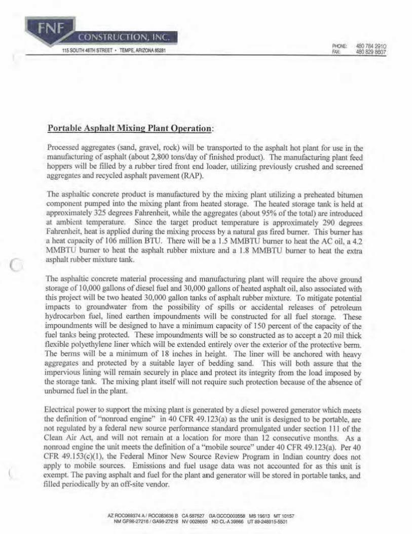
Portable Asphalt Mixing Plant Operatiolil:
Processed aggregates (sand. gravel. rock) will be transpo1ted to die asphalt hot plant for use in the manufacturing of asphalt (about 2,800 tons/day of finished product). The manufacturing plant feed boppers will be filled by a rubber tired front end loader, utilizing previously crushed and screened aggregates and recycled asphalt pavement (R/\.P).
The asphaltic concrete producl is manufactured by the mixing plant utilizing a preheated bitumen component pumped ioto die mixing plant from heated storage. The heated storage tank is held at approximately 325 degrees Falirenheil, while Lhe aggregates (about 95% of Lhe total) are introduced al. ambient temperature. Since the tw-get prod!uct temperature is approximately 290 degree$ Fahrenheit. beat is applied duriog the mixing process by a natural gas fired bumer. This burner has a heat capacity of I 06 million BTU. There will be a 1.5 MMBTU burner lo heat the AC oil. a 4.2 MMBTU bumer to beat the asphalt rubber mix1ure and a 1.8 MMB11J bumcr to beat the extr11 asphalt rubber mixture tank.
The asphaltic concrete malerial processing and manufacttuing plant wi ll require the above ground storage of I 0,000 gallons of diesel fttel and 30,000 gal lons of beatcd asphalt oil. also associated with this project will be rwo heated 30,000 gallon tanks ·of asphalt mbber mixture. To mitigate potential impacts to groundwater from the possibi lity of spills or accidenial releases of petroleum hydrocarbon fuel, lined emthen impoundments will be constructed for all fuel sLorage. These impoundments will be designed to have a minimum capacity of 150 percent of the capacity of the fuel tanks being protected. TI1ese impoundments will be so constructed as to accept a 20 mil thick tlexible polyethylene liner which will be extended entirely over die exterior of the protective berm. The benns will be a minimwu of 18 inches io height. TI1e liner will be ancl1ored with heavy aggregates and protected by a suitable layer of bedding sand. This will both assure that the impervious lining will remain securely in place -and protect its incegri ty from the load imposed by U1e storage tank. The mixing plant icselfwi ll not require such protection because of the absence of unburned fuel in Lhe plant.
Electrical power to suppo11 the mixing plant is generated by a diesel powered gcneraior which meets the definition of "nonroad engloe" in 40 CFR 49.123(a) as the wlit is designed robe portable, arc not regulated by a federal new source performance standard promulgated under section I J l of the Clean Air Act, and will not remain at a location for 111ore than 12 consecutive months. As a nonroad engine the unit meets the defolition of a "mobile source" under 40 CFR 49.123(a). Per 40 CFR 49. I 53(c)(l), the Federal Minor New Source Review Program in ladiru1 country does not apply to mobile sources. Emissions and fuel usage daia was not accounted for as this wut is exempL The paving asphalt and fuel for the plant and generator will be stored in portable tanks, and fi lled periodically by an off-site vendor.
AZAOC06937•Alfl0C08363.6S CA587527 GAGCOC>oo3568 MS19613 MTIOIS7 NM GF98,27218/ GA98-m1e NV0028660 NDCl-A:39866 lfT89-2"891S-5501

C
[lll111+HJll11fi§li§i. \15SOVTIUl!THSTREET • TEMPE,AAIZONAB5281 - 4807642910
FAX: 480 829 8607
It is anticipated employees will geuerale solid wasLes at a rate of about a 3 cubic yard dumpster Joad per month. These wastes will be removed from the site and disposed of al a facility designated for such use. Bottled water will be used for drinking. Chemical toilets wil l be used on site and no telephone service is proposed. This site has adequate area to accommodate any parking demands generated by this project. Aggregate, asphalt and sand & gravel processing plants are not known to i-equire a significant amount of police proteciion. This combined with the site's remote location, resut ls in a very slight potential for significant po lice protection impacts and results in no need for new or aliered services.
AZAOC000374A/AOC0836368 CAS87527 0AC3CC0003S58 MSt9613 MTIOl57 NM GF!16-2721&/ GA98-2?2t8 NV~ ND a.-A3M6 UT 89-248815-5501

(
EPA Form No. 5900•342 EPA I CR No.1230.27
0 MB Control No. 2060·00 03 Approval expires 4/30/2017
United States Environmental Protection Agency General Air Quality Permit for New or Modified Minor Sources of Air Pollution in Indian Country https://www.epa.gov/trjhal-ajr/trjbal-roiooc-oew·source·revlew
Request for Coverage under the General Air Quality Permit for New or Modified Minor Source Hot Mix Asphalt Plants in Indian Country last Modified: January 4, 2017 Version 1..0
Prior to construction or modification, complete tllis app lication and submit it to your reviewing authority. A list of reviewing authorities, their areas of coverage, and contact information can be found in Attachment D to the General Air Quality Permit for Minor Source Hot Mix Asphalt Facilities or visit: https://www.epa.gov/trlbal•alr/S-sourcecategories-hot•ml~-asphalt-plants•flnal•rule .
For assistance with this application please contact your reviewing authority.
For instructions on completing this applicat ion please see tlie document " Instructions for Requesting Coverage under the General Air Quality Permit for New or Modified Minor Source Hot Mix A$phalt Plants In Indian Country.•
Section 1: Contact Information
1. Business Name:
F 1FC . j ' N , -~ 11 \J' ,OV\ D"C~ 3. Site Address: -rownsn ~p a1 tJ se Y4 Sec.,-\~o, 11 flWla P nc r.= s. Name of Operator at Site (ff different from owner):
$A\%e. 7. Owner:
Fl'JF CoV)st r" c\(o,,. JJ'IC~ 9. Owner's Mailing Address:
l I 5 s I y ~~ s-t I ,empe, A-~ y;£39Ssl
11. Authorized contact regard ing this permit application:
Name: Tre.S:::,1-,4 Coll\i-f'~ "('/'t' s (l Title : el'\V,{01'\ m~V\'rM IV\A-li\A-9e. Phone: 4%b ~q~Clf-(.,1'2>3
Request for Coverage: Hot Mbc Asphalt Plants Version 1.0
2. Date: tJ-\5- \l 4. County: lo IW\AC O I A 2- 8io 5 05
A-Pf'rcl.,. .e.. 6. Phone of Operator or Contact at Site (if different from owner):
8. Te~hone Number of0wnl;£ 8,0 ~ll!:lct - <a, 3
10.Send all correspondence regarding this application to:
Company Name: fl\l F- Co t'IS,+ructi'un I I}'lC.. c/o: T(e..'=>'::., I,, CoY\-t+e('Pt.S Address: ll '5 S, 4 ~t-\,\ S 1
Te.V\'\.fe, kL 8'tic?-i1
Email: 'f fe,SS ~A- @ Ft-Jr: r1C,Cowi FAX: 4 '60. Cj 'J..\ - %-7 'J..O
Pase 4 of 25

(
EPA Form No. 5900· 3.42 ePA ICR No. 1230.27
0MB Comrol No. 2060-0003 Approv:d expitts4/30/20J 7
Section 2: Facility Information for Requesting Covrerage under the General Air Quality Permit for New or Modified Minor Source Hot Mix Asphalt Plants
12. Please list all of the site locations for which you want approval to locate your hot mix asphalt plant. Include the site name (If any), street address, city, state, and name of the Indian Reservation. If needed, use additional paper. You may seek approval for additional locatlons in the future.
Site Name Street Address City/Town Area of lndfan Couo""' ? ..... _~
Ol~t-e.'e ,.--. . - I.Jo S-\< e"" A..U ~ss ( -Av\ lL..\ ~ ll'Z.. N fl.I) A-' '"' c ·~ 1/1 , "' -- 1 ,O V\ ,-~ ' -r ...... . 11\ .. hill ", tJ (] / - 0 -i'\t., r-
I ~1' ! 5 t..4 I 'l., l "~ 1-1-JI!. oq r lQ II ,l lo
.
C:.eQ.. 7\I I .:- ,.:>A. m t:u1 .
13. This application Is for (check all that apply):
0 Modification of an existing hot mix asphalt facility. Please describe the modification below. The definition of •modification" can be found at 40 CFR 49.152(d), and In the " Instructions" document.
0 A hot mix asphalt operation co-located whh a stone quanrylng, crushing, and screening operation and seeking to limit combined PTE to less than 100 tpy for NSR·regulated pollutants. You must comply with Conditions 17. and 20.b. in the General Permit. This option is not available in serious, severe and extreme ozone nonattainment areas and serious CO nonattainment areas (please describe the proposed source).
Request for Coverage: Hot Mix Asph•lt Plan<S Version .1.0
Pa&• Sof lS

(
EPA form No. 5900·342 EPA ICI\ No. 1.230.27
0MB Control No. 2060.0003 Approval expires 4/30/2017
14. North American Industry Class1ficarion System/Standard Industrial Classification Code and/or description of the facl!!!)'.: $.Lt. ~951, 1t\W1.1X. 35oTff4 CR\lm m,x-e:{l... 1 A..;Phl}.\tM~X,nj .p\~fil:
15. Type of Asphalt Plant: (check all that apply):
D Stationary gPortable D Batch Mix O Parallel ~low Drum Mix ~ Counterflow Orum Mix
16. WIii your new or modified faclllty be located in an ozone nonattainment area? Information on the ozone attainment status of the area where your facility is/will be located can be found at: hrtps://www.epa.gov/green-book.
Oves Jgf No
If you answered 'Yes,' specify the classification of the ozone nonattainment area:
D Marginal D Moderate D Serious Osevere D Extreme
Note: If your facility will be located in severe or extreme ozone nonattalnment area, It does not qualify for this General Permit and you must obtain a site-specific permit from the reviewing authority.
17. Will your new or modified facility be located In a particulate matter (PM10) nonattainment area? Information on the attainment status of the area where your facility is or will be located can be found at: htt-ps:/Jwww.epa.gov/green-book.
Oves ~No
If you answered 'Yes,' specify the classification of the PM10 nonattalnment area:
D Moderate D Serious
18. WIii your new or modified facility be located ln a particulate matter {PM,.s) nonattalnment area? Information on the attainment status of the area where your facility is or will be located can be found at: https://www.epa.gov/green-book.
Requen for Cove.rage: Hot Mlx Asphalt Pl.ants VerSlon 1.0
Oves ~No
Page 6of 25

EPA Funn No. 5900·342 EPA ICI\No. 1230.27
0MB Control No, 2060-0003 Ap-proval ex-pi res 4/30/2017
19. Will your new or modified facility be located in a carbon monoxide (CO) nonattalnment area? Information on the attainment status of the area where your facility is or Will be located can be found at: https://www.epa.gov/green•book.
0 Yes ~No
If you answered 'Yes/ specify the classification of the CO nonattainment area:
D Moderate O Serious
20. Will the PTE of your new facility, or the increase in potential emissions from your modified existlng facility, be equal to or above the applicable minor NSR thresholds listed below for ANY of the listed pollutants, both In tpy? Emissions from your facility may be calculated using the calculator available online at: https://www.epa.gov/tflbal· air/S-source-c;a1egories-hot-mix-asphalt-plants•final•rule. Be sure to include all new or modified emission units at your facility.
Pollutant AttafnmimtArea Nonattainment Area
co 10tpy s tpy
Particulate Matter {PM) l Otpy s tpy Particulate Matter
{PM10) 5 tpy ltpy Particulate Matter
{PM,., ) 3tpy 0.6 tpy
Sulfur Dioxide (SO,) lOtpv 5 tpy
Nitrogen Oxides (NO,} lOtpv s tpy Volatile Organic
Compounds (VOC} Stpy 2 tpy
~Yes D No
If you answered 'No,' your source is likely exempt from the minor NSR program. Please contact yourreviewlng authority to confirm that your facility will not need a permit. If you answered 'Yes,' continue on to t he next question.
21. If located In an attainment, attainment/unclassifiable or unclassifiable area, wlll the PTE of your facility be less than 250tpy for PM, PM,0, PM,.,, VOC, NO., CO, and SO,, each individually? Be sure to Include all existing, new, and modified emission units at the facility.
_l8l Yes D No
If you answered 'No,' your source does not qualify for the General Permit. Please contact your reviewing authority to apply for a site-specific permit. If you answered 'Yes,' continue on to the next question.
ReqUe.$l for Coverage: Hot Mix A.sphalt Plants VersJon 1.0
P•s• 7 of 25
C
EPA Fol'ln No. 5900·342 EPA ICR No. UJ0.27
0MB Cono·ol No. 2060·0003 Approval explru4/ 30/ 2017
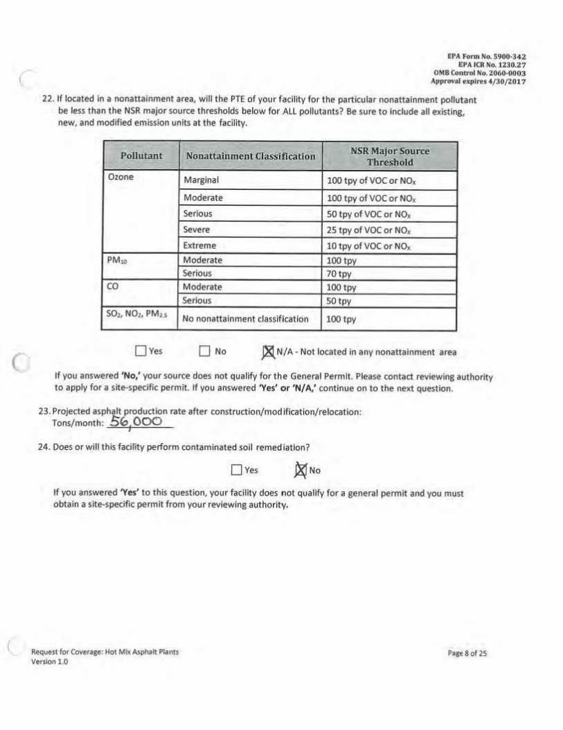
22. If located In a nonattainment area, will the PTE of your facility for the particular nonattainment pollutant be less than the NSR major source thresholds below for ALL pollutants? Be sure to Include all existing, new, and modified emission units al the facility.
~
Pollutant Nonattainment Classification NSR Major S0u11ee Threshold
Ozone Marginal 100 tpy of voe or NO,
Moderate 100 tpy ofVOC or NO.
Serious so tpy of voe or NO,
Severe 25 tpy of VOC or NOx
Extreme 10 tpy of voe or NO,
PM w Moderate 100 tpy Serious 70tpy
co Moderate 100 tpy
Serious 50 tpy
SO:, NOi , PMu No nonattainment classifi cation 100 tpy
0Yes D No ~N'/A-Not located in any nonattainment area
If you answered 'No,' your source does not qualify for the General PermlL Please contact reviewing authority to apply for a site-specific permit. If you answered 'Yes' or 'N/A,' continue on to the next question.
23. Projected asphi/!t production rate after construction/modification/relocation: Tons/month: 5~ 00('.)
24. Does orwlll this facility perform cont.iminated soil remediation?
Oves ~No
If you answered 'Yes' to this question, your facility does not qualify for a general permit and you must obtain a site-specific permit from your reviewing authority.
Request for Coverage; Hot Mtx Asphalt Plants Version 1.0
Pages of 2S

E'PA fonn No. 5900·342 EPA ICR No. U30.27
OMR C.,ntrnl No. 2060·0003 Approv.11 expi~S4/30/20t7
Section 3: Technical Information for Reques ting Coverage under the General Air Quality Permit for New or Modified Minor Source Hot Mix Asphalt Plants
Information regarding the emission units at your facility Is required by 40 CFR 49.154 and 40.160. Please provide the infonnat ion below for all equipment at your facility. For each emissions unit, Include supporting documentation for the PTE of the unit with your Request for Coverage. In addit ion, for existing emissions units, include the most recent actual annual emissions. See 40 CFR 49.154(a)(2). (For more information on how to calculate actual emissions, you may go to: https://www.epa.gov/trlbal•air/reglstratlon-exlsting-true-minor· sources-alr-pollution-indlan-oountry.) Asneeded, please include other relevant information with your Request for Coverage (including any equipment not ident ified below).
Dryer
25. Dryer ID: 9 /o - 0 \
26. Construction/Modification Date ofthe Dryer (mm/dd/yyyy; actual or anticipated):
27. Dryer Burner Capacity (MM Btu/hour): _ _:l...cO=-lc=------28. Fuel(s) Used In the Dryer:
Ill( Natural Gas D Propane D Distillate Fuel D Biodiesel
( 29. Is the dryer/mixer controlled by a baghouse (fabric filter) or venturi scrubber?
~Yes
If you answered No to this question, your facility does not qualify for a general permit and you must obtain a site-specific permit from reviewing authority.
30 Internal Combustion Engines (Including emergency generators)
Maximum Typ·es of Manufactured Unit ID
Rated Capacity Oate ti Unit Descl'lptlon .Fuel(s) Used,
{mm/dd/yyyy) (HP}
O\J - Q 1Pli... e D ,ne.... w,\ e, e.. \JSe.O,
Model Y11ar
1 Only diesel fuel or blodiesel are allowed 1n this General Permit.
Reqvest for Coverage: Hot Mil( Aspha1t P.lants P•g• 9of 25 Vers.lon l ,O

(
C
31 Auxiliary Heaters
Maximum Heat Types of Unit ID Input Capacity
# lfnit Description (MMBtu/hour)
l'uel(s) 1Jsed2
q l.-dl ie:i 'i I I! eA-t e,,2. t, c; Ak,t; 11 A-i (.
b:l.·01 !:S,-Pn~~'i~e~ 4 , ?. II
b1-2L o~\ He.A--+e~ l I QI 11
Total Heat Input Capacity:> ,.5 32. Material Handling, Transferring, loading, and Storage Equipment
Marjmum Construction Unit ID Capacity Date
#- Unit Description (ton/hour) fmm/dd/YYYJI)
~
II
11
11
" II
fl
ti
II
I /1o l \qq2) IC\86
\ I 1 000 \H\~
'1er,\-A! 1v~ r M c.i~ Thr.lL 111 e>OO \.J '(\ I(_
1 Only natural gas, propane, distillate Ivel and biodlesel are allowed In this General Permit.
EPA Fonn No. 5900·342 EPA JCR No. 1230.27
0M B Con trol No. 2060-0003 Approval expire!i 4/ 30/20·17
Construction Date
(mm/dd/yyyy)
~ J,f~ol"-I/ 10' f 1q<r3
1f, ( 1Q SI:, '
Type of Gontrol (if
any)
s.e.
e N
4 N Pr
tJ /4 WI\- y
l!til tv\A-NI A-tv I A-Nl4-
' In order to qualify for this General Permit, the total heat input capacity of the auxiliary heaters cannot exceed 10 MMBtu/hour.
Request for Coverage: Hot Mix Asphalt Plants VefsiOn 1.0
Page 10 of 25

(
33. Volatile Liquid Storage Tanks
EPA Forni No. 5900•34-2 EPA ICR No, 1230.27
0MB Control No. Z060•0003 Approval oxpires4/30/20l 7
This section applies to storage tanks used to store liquid materials. Please provide the following information for each storage tank.
Unit ID# Type of Liquid
capacity (&iillons)
34. Threatened or Endangered Species
Vapor pressure.of Liquid (psi)
Is the tank !lboveor
underground?
Date or Installation oiexistlng)
"' A-, , I l
Have you demonstrated that you meet one of the criteria !listed In Appendix A with respect to the protection of any and all species that -are federally listed as threatened or endangered under the ESA or of habitat that is federally designated as ·critical habitat• under the ESA? If you answered 'No,' you cannot request coverage under this permit.
Jl(ves O No
If you answered 'Yes,' then you need to provide the appropriate documentation to the EPA to qualify for coverage under this permit. Please indicate under which criterion in Appendix A you are satisfying this requirement:
~A Os De Do De
35. Historic Properties Have you completed the screening process in Appendix B to determine if the construction, modif1tationor operat1on of your new or modified minor source of air pollutants has the potential to cause effects to historic properties (pursuant to the NHPA)? If you answered 'No,' you cannot request coverage under this permit.
~Yes 0No
If you answered 'Yes,' then provide the appropriate documentation to the EPA to qualify for coverage under this permit.
RequeJt for-Coverage; Hot Mix A.$phalt Plants VerJion t .O
Pag! ll of 25

C
SPA Forni No. S900•342 EPA ICR 1/o, 1230.27
0MB Control No. 2060•0003 Approval explres4/30/2017
Section 5: Additional Information about this Gene.ral Air QuaJity Permit for New or Modified Minor Source Hot Mix Asphalt Plants
This section provides information on the sizes of sources In terms of emissions t hat are eligible for the General Permit. The emlssion limitations and standards in this permit are expected to ensure that source-wide emissions are belowthe rates shown ln the following table:
Attainment, Unc.lassifiable Pollutant or
of Cone.em Attalnment/lJnclasslflable Area$
co 80tpy
PM,o 26tpy
PM,s 14 tpy
so, 18 tpy
NOx 71tpy
voe 28 tpy
Request for Coverage: Hot Mix Aspllalt Plants V~rslon 1.0
NonattainmentAreas
80tpy I moderate areas I
40tpy (serious areas)
26 tpy (moderate areas)
26tpy (serious areas)
14tpy
18 tpy
7ltpy (marginal and moderate ozone area.s)
45 tpy (serious ozone areas)
28 tpy (marginal and moderate ozone areas)
18tpy (serious ozone areas)
Pag, 12 of is

(
EPA Form No. 5900-34:t EPA ICR No. 1230.27
0MB Control No, 2060-0003 Approval expires 4/30/ZOJ. 7
For a hot mix asphalt operation co-located with a stone quarrying, crushing, and screening operation, the emission limitations and standards in Conditions 17. and 20.b of the General Permit are expected to ensure the source-wide emissions are below the rates shown In the following table:
Pollutant Attainment, Un classifiable
of or
Concern Attainment/Unclassifiable
Areas
co 78 tpy
PM 86tpy
PM,o 63 tpy
PMu 30tpy SO, 18 tov
NO, 90tpy
voe 27 tpy
Reque.u ro, Co~raee.: Hot Mhc A.sphalLPlanu ve,sion 1.0
Nonattalnmen tAreas
78 tpy (moderate
Not applicable
(serious areas)
Not applicable
63 tpy (moderate
63 tpy (serious
30tpy
18tpy Not applicable
(serious and above ozone areas)
90tpy (marginal and moderate ozone areas)
Not applicable (serious and above ozone areas)
27tpy (marginal and moderate ozone area.s)
P•ge 13 of 25

EPA Porn, No. 5900•342 EPA ICR No.J.230.27
0MB Cnnll'ol No. 2060,0003 Approval explres 4/30/ 2017
You should contact your reviewing authority If you Intend to r ely on the emission limitations and standards In this General Permit to prevent having to obtain a Title V permit.
A~nlkant's Statement ( to be sianed bv tbe•annUcantl
I certify that this document and all attachments were pre pa red under my direction or supervision according to a system designed to assure that qualified personnel properly gather and evaluate the Information submitted. Based on my lnqufry ofthe person or persons who manage the systenn, or those persons directly responsible for gathering the Information, the Information submitted is, to the best of my knowledge and belief, true, accurate, and complete.
Name:~Q'i).~ ~ ~l\.1J\.P.I Name: (Signature)
Title: ~'; fOV\m~M~
Requtst for Covl!fage: Hot Mi.le Asphalt Plants V~ts.ion LO
v'n M'l A-$J e rL
"TreES'i ~ Go"--\-(e'fAS Date: ~-lff-r7 (Print or Type)
PagH4 of 25

--
No,tt,
0 0 ~OOM ... --===--== F'W F ~oT f>\Av\T s;;,e_ A"f 1''1\-t.. ~V\A ~ ~1Z.~0"-.1 Sove.ce.

Ganado Borrow Source FNF Asphalt Plant Site
Go gle Earth feet rreters
I~~•
• I
'!i.
1000 500

PT!Ooo!Yd ,,_,,. o--11MDcer Loao~ilo Fir.--
"°"' Sa.., .... .... ~Heatl!I' ..... Tctal PTE
(
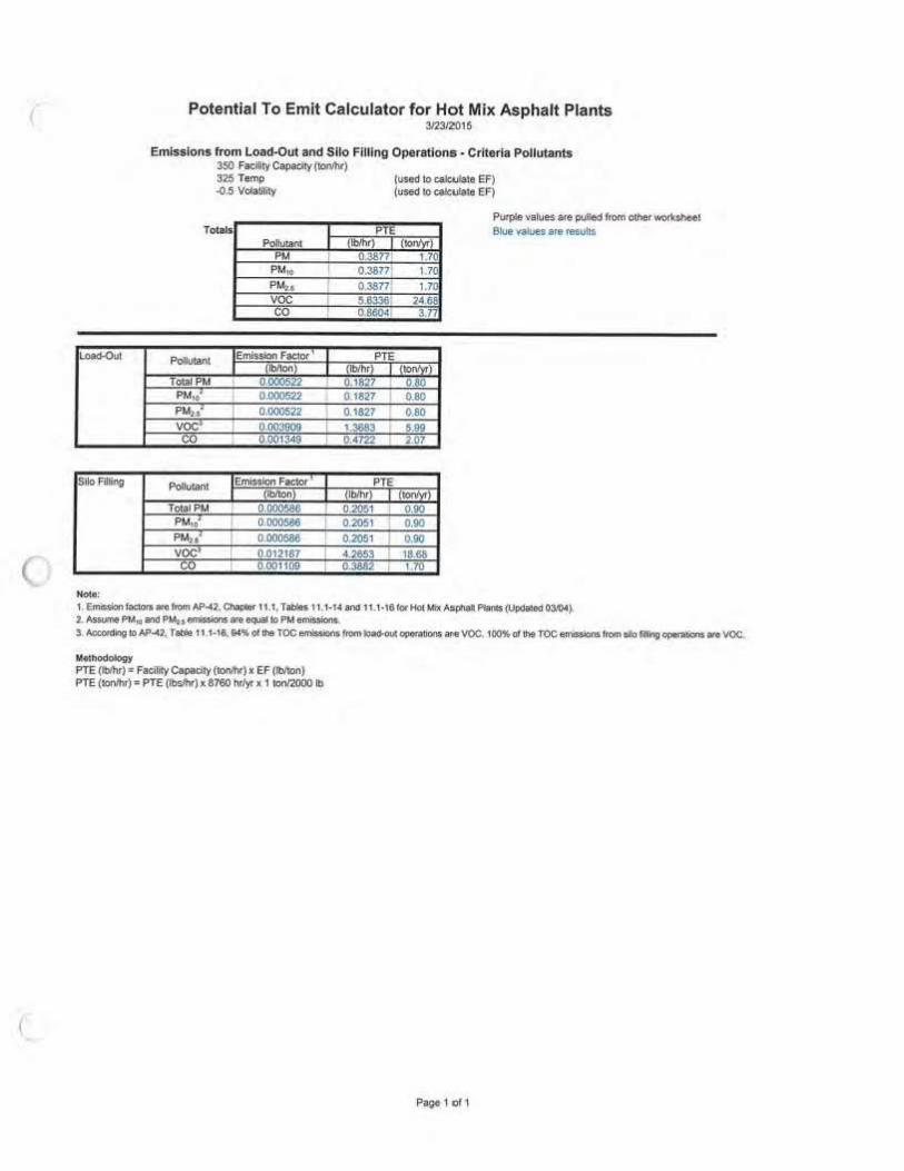
Potential To Emit Calculator for Hot Mix Asphalt Plants 3.'23i2G15
O,i,r ,., ,.
PM F'M,o PU., so, NO, co ,... 3 . .... 16111) 68:' 100.3 170 1.7() uo . . 3.77
2:100 SAJ a.4:f . . J.37 1.13 Oi . ,.,. .... ' . .
""' 4.82 ,,,,. . . OA7 -·,,:77 0.60 o.o .. , 1.17
":00 0.00 • 0.0 .. .,, ... ,. 20~· ..... ... z.,s 2N,2J
Page 1ot 1
voe 411.t 24.6&
.
.
. 0.00 0.00 73,at

C
Potential To Emit Calculator for Hot Mix Asphalt Planls 3'2312016
T .. Ul'Nlb ... t.ic. .... "' •• II fH*ilr\ OOW,116'. ... • .. ~ •• "- ODn• ........ oflNI !N"'!.-cl Cllt!ffl1;i,vl~ EPAOOM IICIIQl!Wln-.N ~ ·, Of IPP,Ofltllill""" ct, .. ~ft EIJ,~·toOr ~ ,. .. ~UI T~bf! \1f 00t1'fdlnr, ~- •t-. ~'JI ,a:,ll!ll,,,t;llly b v·mt, ltle~~ ;itir. ... ~ f PA• riel llllllt fOf #'T.!t • t;r,IIUICll!I.
Dilecfc!!* . £ttlar Vie fadily's '""7NISon below. 'Ntl1e.lhe lon1r"V'-o,: ·w-·nexito-"' tu'1twe IO~ lhallilit&dlty dcNts 0( clOH IIOI NII !hM !)'Pf OfW
~ llG',ell!UI emi»lo<W al a.,. oallatr'!ls «or f'II fdty Ml :11 ~t)'td ~ U,e "Olltput • Ct1!en1' lab.
,..._. Ult: ~ilk' 1to!IJr' ~ to 1111P; ~ ... .$~1 IO t,.'SPS. s..t'l)lt\1 l•• .. PM«'nlSt•:1!111311: W11 comroMd}lf'IO ont, ~ lo l!'a ltt(lfiell ownt.~ W. :i.,._. OCJl'IV1*!rbf .... '""" n.,. ,-UO'l (&::w, It, Ille tll'lWl-con!rOlled o,,~,, - "'°' ~ •• 111111 ,pt.~...,. W-111111 af SCt\lllMrs toCICl'"tei&afflllll,.... .. fllfllt
If 'ffN •r. tl()T $\lbjtCI 10 NSPS-. ~" l, lht. PM'R\!1M'M2.$ llff$Klft ~ }'I lhil. .~ .. cs,,_ NM 11, be ,.,,vis«d lo i,. bfsed °" itw \lnDOIIIIOlld .,..IOI\ ,-,, F ,cHf.., Prcfl&a
Tyoe of PfMII, ...... .. S.ltcl '"01\n>' 01 ~!ah' PO'b fie ct~ tn6nU-Plant C111*11)'- ,...., '""""') ......
!kl'IWS!t'e- "' (~r)
Pu1l1 Usto In Dryu ~w•Gn- (VorH)
~F·(~. -el,ete.) " (Vorf\l)
A.\M Lbie UI .. "' f"'ei!OilL %> Defall-: JS M.x HolJl1', Lime~~ .. "") D.ta..11 •2$
Bit! ¥ere f!klenQ"" - '"' OefNI ., Q81i,
"99,11911.e Mfli: RN> Used- .... (1') o.1"111111 .. 50K RAP• ReeloiMd A$?0~ Pa~emlftt:
I of V19n AO;, -C'«!Yt:)'Q!S> ' (") I ct Vlrg.-. J,gsi. S«et,,_. ' ~l #olRAP~r,. ' )
I d AAP SCrNnP. ) Apjlfegat.e Mok1111e, 1%) On.A\• 1.8~
A~ la,y Httt .... C-..,tdlv • 7< , ..... ...., , ... F"UMU$ed
......... o..- " ('I Otlfl - " CY or M'l ......... LIQu.dfuel fdltlllltt. d\esel, , ic.) V ('fo,N) 0.00l5- D*ll .. 0.0015
G1n11r111~9lnt sin-- 0 (ho) Noa EflGIM• llt;t4 n ccosloecea pxlata rornn;;d 91\0inel do mt Fv•llUM $>-h• 11eed 1111 be lncklclell (MIii 40 C:FR 1()6$.30)
°""'' • ('IOIH) 0.(1)15 Ott.A• a oc»a
°''* P1r1mot1r.
"'4Jt11lt Ptopfftios T•ml*f.,,._ ,,. (F) Dem.11 • 32:1 v- ... (i.ndess) ~-a..O,$ -.. Mf1an Wl!IC$- .~ ., '"""' W<n1tCan'"'16
~ 1 011

C
Pl C<ll r-MIJ
Potential To Emit Calculator for Hot Mix Asphalt Plants 3l23J2i01S
Emissions rr om Drum Mix Hol Mix Asphalt Production· Criteria Pollutants 350 '°""'
PM p
Polklta11 PM
PM• PM,. SO, NO, co
V
I I
I
I
I
PTE PdlWo~ I Emkw)nF""ilCIQI' r
' I 11,110 ,,-i
= · 0.0029 I
Puri:te 'laloe, •te pulled tori! ctlw wotk!lhDM. Bt.w •llllum .. ,al.lb
PTF ,,_ (
1Ui51 '°f us 3S 102 ... 119 , ... ... S&.2$ .... .. .,.
11.201 4906
1-ffiil! IOns ,.,,...1 ' I 02 ...
NOie: 11119 iSc lhe en'IISSIOn IIICIOf kW' the d COfWCllocf ,,, «t)' lill0f$.
S0,1NO.:,'CO pre Nakrl!I aa~ Lt:1!Jtl FIJS
F'Gk.CM I ElfliSabn f .. ""'"'""' Polll.unl 1t:m1Hron.Ffld0t 1 EtniUiot'G · I 1!1)11onl 1 ll)'ly' I 11 I {ll)'lon) I Jlb/Twl I /!Qn!llrl
so, 0,003, 119 521 so, 0.011 ( 000 ..... No,. 0 ,026 11.10 39 ... NO, 0.03$ 0.00 "'2, rn ... •MD 199.:>i co ... 0 00 ' 19!1 ~9
·~ P E PelhAMi. IEll'lfsliOn FJctor I Emlssbs
. I flb'tcn' I (lb'ff\ I (10 )
voe 0002 I " • 9.06
Hot• ! 1, Emis.sloofKlof's a,e~Al'llll .C~ 11.1, Tllbln 11,1.3. 11,\-4, 11,1•7, - l l,MI fo, HclA.~ "5pt\lflPlaits t~ieo0)12004), 1i.:*'t«HOlr'"'4!1 Nols2. '2. NOx eltlb,lon factor fut k;lad Nd bas:ed en T edlrical $,;ippctt ~ ,0, A$111Wl Ft~ tJf WasHnglO'l', 0-eownen! d ~ (11~ 01'201 I~ VIIUI tw.lld on 20 ,-. ol ~.-.c. 1n1 dllo • 75111 IM"Celllile Pl.ll ~
ltell'lodOlot)i PTE (lblhr) . Faeil•y Capldy (ecwtw)x EF (ltltl(inJ PTE (lon')1"1: PTE (lbe,llv) x 8760 ITlyr x t lon'2000tb
P8tgo 1 Cl 1
(
Load-Oul
Silo Flllfni
.....,,
Potential To Emit Calculator for Hot Mix Asphalt Plants 3123/2015
EmJs.slons from Load .. out and SIio Filling Operations· Criteria Pollutants 350 Facllity Capacity {l«llht) 32$ Temp .().fi Vota!llily
Totals PoHutant
PMui PM,, voe co
PolUIM,I I Emlssbn fae10t ' I nbhon\
Total PM 0.000522 PM1~· 0~ PM,,' I 0.000522 voe• I 0003909
noo1349
PollUtanl lemi$Slon Fact.or I (!Mon1
Tota1PM I 0.000586 PM,o• 0.000566 PMu ~ I 0.000586 voe• I 0.012187
0.(XH 1D9
I
I I
I I
I
I
' I I I
(used to cab.Jla:e EF) (used ,o co1e,,1,11• EF)
P'1'E {lb/ht) I (IOn/y,)
0.38771 1 70 0.3677 1.70
0.3877 1.70: 5.6336 24.& 0.86041 3
PTE {lblhr} I (tol\/\lJ1
0. 1827 I 080 0 1827 0.80
0.1827 080
J.3883 Mil 0 . .4722 2.07
PTE • lb/hr) I IIOOl'yrl
0.20~1 0.00 0.2051 I 0.90 0.2051 0.90 4.2653 18.68 0 ,388:2 ! 11•
PurpSe values a:re pulled from 00,er worksheet Blue vaaues are res:ulis
1, e,n5$k,n roe1ora att: &om AP~2 .. ChilP'Cir 111, Tat>IK l I, 1-U anc, 11.1-16fOtHolMix Mptllll PlilntstuPCIIWled03.I04).
2. AS&l.#IMI PM,a ill!ld PM, 1, eml!ISions are ~ I!> PM emiSsions. 3, Accoroirlg 10 AP""42, Tat'l6e 11 .1-16. 94~ ot lhe TOC errm,i0n$ftom'*"ovc Ol"'f•ll00$ <Ille voe. 1~ ot 11'18 TOC e~ rtom Illa fi~O~ .,_ voe.
M.ethodo6ogy PTE (lt>Jhr) = FaciliifyCa1>1cil)'(IOfll'rlr) x EF (blton) PTE (IOn/hr) = PTE (lt,on,,) x 8760 hrl'Jf x 1 tonl2000 lb
P~1of1

C
~ r:.....,w,a ,.iat ~
~
.... ..... ,....i
"'· ~ .. l::~~ - _ .. _ I' ... ' ~ --t-111'>7 ..... ~d\#ill
PotenllaJ To Emit c,1c-uJato1 for Hot Mix AsphaJt Plants
"""'"
"' ' , ... . .. -· ... .... ...
~~ ... &11,.,.,.. ,..,.. . i~ I ~ !I~\ '
,_, 1,. ...... "-ffl
• ' U\l<I. • ' ' om ' ·- !If~ •ro f>t'OU
,_ --""· f r .. ,.IQl'O,
..
·-l ~~-':" ~·-· ' -· ~~ , .. • - ,..,.,, .. ,.,--1 • • • ' ' 0,1,1 ~ • flM !J ,o .,,,, '<-'II'> -, ""----11¥,""40-11.w.1- ,i1u~111o ~-~-~.._.......,.,.,.....,_GM,11 n. _____ ..... __ .......,_. ....... ""' .. '° '" ....... 1-~.----....... ........
""~·' ~ -, - ' ' ' ,~ 00011 o:1.:m1
' ' • , . ' ti..( ' .....
• • ·-- ' ·- ----.111...-....1 ' ·~ • " .. , "'""' • ' ' ·~

-
Potenllal To Emit Calculator for Hot Mix Asphalt Pl,nts
"""""
~lf(l li!rJ,PJO. ~ 1U4 . .... H•'\l~•r,fltl,,f•pti,.~ llfOClj,h,:,o,lkuill•tm~r-,111 II0>¥11Jkr..t11 • ........ '"'"'._ ~aQ\111.,..
ff• ~'"*"(~ .,."-'!l;tt~~-· Us. IJM11111M.-,l1'fl"tl)• M• MaitJUr• lllnlllilC('I •
• - - ' -.... "'· ...... ·-
,., -"" t.l•,... JIM. Ul ler-l'M., ....,; IIOGStorf'\1.,-,
,, .. ~(fflvliilllltr ttit~> f. 1'1./~tv••....,>
' ' " ..., .,,
I ll!q-f~•~IION~S. ~ \,tr.p~~~!Ol.i'l'°'""1tor--.,p;1••-..,.,hl~!(i')I.

Potential To Emit Calculator for Hot Mix Asphalt Plants 3/23/2016
Ume Silo Loading ~ Ml<, Hourly i...d {1x>nlrn)
98% Bin Ven1 Control at1¢leney ("-)
Lime Silo Loading Con1rotiecl (8;760 hr/W)
P~Wnl Emission F a.c.klr Control Eff.
t~n) "' PM 2.2 98% PM1/ u: 981, PMu ' 2.2 981,
Nott!
(IMvl
11 1.100
1.100
PTE {tonn,r)
4.82 482 ·~
Purplt va.luos art pU:Jled from o'.he:f wort:sheel Slue v11U1t ,ire .-eo.ults
1 Emls&ion r~ ant ~om A~2. Chaplw-11 17, laDle 11 f7~ '°' Lime M.i""fitduring (Updaled 02m)(SCC 3-0S-Ot6•t5), 2. As.stm6 PMio and PMu, emi~$b($ ar111 _.,., 10 PM etniRIO!'&
M• Uu~dOIOg)' PTE (lblh<) = Max. Hourly Load (Ion/hr) x EF {lbllPn) X {1-Conttol EN.) PTE (ton/l"lr) s. PTE (lbJhf) x 8760 hr/yt x 1 COn,'2000 i>E
Paga 1 of 1

Fuel Type:
FueJ Type:
Fuel Type;
Potential To Emit Calculator for Hot Mix Asphalt Plants 3123/2015
Emissions from Auxiliary Heaters· Criteria Pollutants 7 5 >!eat fnput (MMB""'1r) Purpfe V3lu8$ are pulled from oltler \\Orkfhfft
Blue va1ue!c are results
Wo<st C••• PTE (!only,) PM so, 00 0.47 0.77 0.60 0.05 4.69 1.11
Natural Gas Used· N
PollUtanl
PM PM,o" PMu 1 so, No,. co Emissfon Facior (lb/MMSCF) 1.9 7.8 7.6 0.6 100 84
PTE (ton/yr) o.oo 0.00 0.00 0.00 0.00 0.00
Noce: I. EmTs,ion fo,r;k>q ere i,in, .\P-42, Chapter U , Tables 1.4-t a~ VM! {upda'led 07198), 2, PM1D t nlGSion '-tilOr ii oo~ble and fflterab1e PM con,~edl. PM o,niuiQn «.<:IOI' Is for sterable PM oot;. !l. AS:CtJffle ~ eimi!:~n, •'* oq1.11I lo PM,.•mis&ions.
Methodotogy PTE (11:l(ll'yl') • HHI h1put {MMBWJl\l'),i 1 MMSCF/1,020 MM8tu i E;F (lblMMSCF) x 6760 tidy, ll 1 tod200() lb
Pro ..... ne Used: N Suttur Conlent: 0.00 % Po111Jlan1
PM PM,o~ PM2.$.1 so, NO, co Eml5$1on Faclor• {lb$/kgal} 0.2 0.7 0.7 0 13 7 ,S
PTE ( ton/yr) 0.00 o.oo 0.00 0.00 o.oo 0.00
Note: 1, Emi$$1on faCIOr$3l'O from AP-42, Chapier 1.5. Tables 1.5 (upaate<I 07/06}. 2. PMto •miNion faqlor it c:onckln.sable and llrerable PM oombfned. PM en\lslCln Mdor Is ro, filtetable PM only' J .At;tumt PMt-, •IT'ifsiOns aro equal to PM,11 1tmlu.iotls.
Methodolog~ P'TE (tan/)',)• Heal Input (l,fMSIIJ/hr) 11 t kQ-all'91,5 MMBIU • EF (t>lkgat) ,c 8780 htly, ,c 1 lfJn/2'000 to
Llnuld Fuel Used: y Solfur Con.lent. 0002 % Poll!MM
PM PM,11' PM,,, so, NDx co l=mis.siop factor' (tblk.gal) 2.0 3.3 2.55 0.213 20 5.0
PTE ( ton/yr) 0.47 0.77 0.80 0.05 4 .69 1.17
Noto:
voe 0.08
voe 5.5
o.oo
voe 1.0
0.00
voe 0.34
o.oa
1 EmiS.SiOn ftctort ttt "um AP~2. Chapter 1,3, Tables 1 .3-1, 1 .3-2., Md 1 .3·3 tor FuM o, Con\Mt.w:ln (\lpcl<l:tiad 05{10), 2. PM,• ~ihlcn faCtor 1$ eondoftsable end fillara.bfe PM comtmed. PM 1tmr&slon tac,or fs fot ~ PM onl~
Melhodofogy PTE (1onlyr) • HUI Input IMM8tulhr) x 1 kgaVl40 MM8a. x EF (lblkgal) JC 8760 hf'l\'t x 1 ~ lb
Page 1 o!1

Llocurnenl No. ___ o:.:0:..:3:..:9;;:8=.2 __ Oace l$SUed 05/20/2015
'""'--EXECUTIVE OFFICIAL REVIEW
TiOe of Oooument FNF Construction Inc /or Borrow Lease Conlact Name: DRAPER, HOWARD Program/Olvision: DIVISION OF NAlURAL RESOURCES
Email: howanldreper@fronliemelnet Phone Number: 928/871-644 7
0 Busfn""" 51111 Leasa 1. Dlvls/Qo: Sufflclent lnsUfficfe'1t
--------- Daill: - --- - -
D
D
2. Office of lhe Conlro4ler: Date: (only If Proc:uremenl Clearar,ce Is not issued wiU>in 30 days of lhe lni lia~on or·"'lh:-e-E=.-=o:-. -,e-vfe~w,,..J-3. Office ol lhe Allomey General; Dale:
- -----
D D D D D D
Business and lndustrlaJ Development Financing, Veteran Loans, (I.e. Loan, loan Guanmtee and Investment) or Delegation ot A/)provi119 and/or M•nagement Authority of Leulng lnmsac:tlons
1. Division: Dale: D D 2. Office of lhe Attorney General; Date: D D
Fund Man11gement Plan, Expenditure Plans, c..ny Ovor Requests, Budget Modlflcallons
1. Office ot Management and Budget Date: D D 2. Office of the Controffer: Dale: 0 D 3. Olllce or the Attorney Generel: Date:
0 Navajo Housing Aulhority Requ01Jt for Release of Funds 0 D
1. NNEPA: Dale; 0 D 2. Office of 1he Attorney Gene,sl: 011111: 0 D D Lease Purchue Agn,ements
1. Office of lfle Controller: Date: D D (recommendaUon only)
2. Office of lhe Attorney General: Date: 0 D D Grant Appllcatlons
1. Office of Management and Budget Date: D D 2. Office of Iha Conlroller: Osle: D D 3. Office of lhe Attorney General: Dale: 0 D
Five Management Plan of lhe Local Governance Act, Delegation of an Approving Authority from a Slandlng 0 Committee, 1.o.,.1 Ordl.nances (Local Government Units), or Plana cl Operation/Division Policies Roqulllng
Committee Approval
1. Division: Date: D D 2. Office of the Attorney General: Date: D D 0 Relinquishment of NIIVlijo Mtmberahlp
1. land Oeparlment ~&: D D 2. Elecllons: Osle: 0 D 3. Office of the Attomey General: Dale: D D
P.1n1an1 lo 2.N.N.C. § 16'8nd """"'1MI OrderNomborOl-21113

0 Land Wrthdrawal or Rolinqui.shment for Commercial Purposes
1. Division: 2. Ofl",ce of Ule Allorney General:
Date: Dnlo:
SufRcJent tnwffJclent
-·- 0 ·-- D
D D
0 Land Withdrawn ls for Non.Commerclsl Purposes. General Land Leases and Resource Leases
1. NLD Date: D D 2. F&W Date: D D 3. HPO 0 &18: D D 4. Mlneral6 Date: D D 5. NNEPA Dale: D D 6. DNR Dale: D D 7. DOJ Dais: D D --- ---
D Assignment of Mlneral Lea ..
1. Minerals 01111,: D D 2. DNR Date: D D 3. DOJ Date: D D
0 ROW (whera there bu been no delegaUon of authority to the Navajo Land Department to grant the Na.tlon'o C1>11""1 to • ROW)
1. NLD Date: D D 2. F&W Date: D D 3. HPO Date: D D 4. Minerals Date: D D 5. NNEPA Date; D D 6. DNR Dale: D D 7. DOJ Date: D D 8. OPVP Date: D D
D OTHER: 1. Date: D D 2. Date: D D 3. Date: D D 4. Date: D D 5. Date: D D
Punuantlo2N.N.C. f 1M andEdCUllvo Onlor-07-2013

r
(
NNDFW Revie\\ No. EOR-003982A
BIOLOGICAL RESOURCES COMPLIANCE FORM NAVAJO NATION DEPARTMENT OF FISH AND WILDUFE
P.O. BOX 1480. WINDOW ROCK, ARIZONA 86515-1480
It is !he Department's opinfon 1he projec, described below. with applicable conditions. is in compliance with Tribal and Federal laws protecting biolottical resources including 111< Navajo Endangered Species and Environmental Policy Codes. U.S. Endangered Species. Mignnory Bird Treaty, Eagle Protection and National Environmental Policy Acts. This form does nol prec;lude or replac• consulla1ion "ilh the U.S. Fish and Wildlife Service if a Federally-lis1ed species is affected.
PROJECT NAME & NO.: Ganado Borrow Pit
DESCRfPTION: FNF proposes 10 obtain a mine lease consis1ing of28.474 acres for borrow extractlon and
processing. An existing access road would be used for ingress/egress to 1he site. It ,s csrimated tha1 only I 0. 7 ncres of
~1e 1otal lease area " 'ill be disrurbed by mining activity.
LOCATION: SE\l,ofSection 13. T27N, R26E. G&SRBM. Ganado. Apache Couniy. Arizona
REPRESENTATIVE: Tressia Contreras, FNF Construction. Inc. (FNF)
ACTION AGENCY: Navajo Nation and Bureau of Indian Affairs
B.R. REPORT TITLE / DATE I PREPARER: The Ganado Borrow Pit/APR 2015/Rocky Mountain Ecolo!I). LLC.
SIGNIFICANT BJOLOGICAL RESOURCES FOUND: Area 5. Approved b)' S. Diswood (date unknown).
POTENTIAL IMPACTS
NESL SPECIES POTENTIALLY IMPACTED: NA
FEDERALLY-LISTED SPECIES AFFECTED: NA
OTHER SIGNIFICANT IMPACTS TO BIOLOGICAL RESOURCES: NA
A VOi DANCE / MITIGATION MEASURES: In addition 10 the mitigation measures outlined in Sectio.n 9.0. FNF
will also construct a be,m between the borrow site and Ganado Lake tO preveni contaminan1 leachintt and surface
runoff into lhe lake.
CONDITIONS OF COMPLIANCE•: NA
FORM PREPARED BY / DATE: Parncla A. Kyselka/12 OCT2015: amended on 15 OCT20t5
COPIES TO: (add categories as necessary)
o ___________ _ o ___________ _ 2 NTC § 164 Recommendation: Signature/ Date
@Approval :..17 /] '°T"J / / _ 0Conditional Approval (with memo) / ~ /IA... / C9I_ ( 6 tr. I~ 0Disapproval (with memo) GlorialM. Tom. Di~ector, Navajo Narion Depanmen, of Fish and Wildlife 0Categorical Exclusion (with request lcncr) 0None (with memo)
C lcllCU,:20 JO.My lloc:um<nli\NNI IP\13RC1' _lill 5\EOR.·003982A.doc
Page I of2 NNOFW -8.R CF · •'ORM REVISED I? NOV l009

• r understand and accept the conditions of compliance, and acknowledge that lack of signature may be grounds for the Department not recommending the above described project for approval to the Tribal Decision-maker.
Representative· s signature
C IOld_p,:2010\M) Documnus\WNIJP\JJRCF_201 SIE0R-003932t\ dot
Page 2 of2 ~'NOF\\ - 8.R.C.F · FORM REVlSEO 12 NOV 2009
Date
(

C
(
BIOLOGICAL EVALUATION & ASSESSMENT OF
THE GANADO BORROW PIT-SECTION 13, T27N, R26E, APACHE COUNTY, ARIZONA
• -~-
-•
PREPARED BY: ROCKY MOUNTAIN llCOl.OGY, LLC
3 0 6 ROSALIE DRIVE DURANGO, CO 81301
(505) 992-6150 [email protected]
PREPARED FOR: FNF CONSTRUCTION, INC.
TRESSIA CONTRERAS 115 S. 48TH ST. TEMPE,AZ 8 5281
- -~
. -11/IDl!lll 14:fl 'Iii
OCTOBER 2015

Ganado Borrow Pit I BE/BA j October 2015
BIOLOGICAL EVALUATION & ASSESSMENT
OF
THE GANADO BORROW PIT - SECTION 13, T27N, R26E, APACHE COUNTY, ARIZONA
PREPARED BY: ROCKY MOUNTAIN ECOLOGY, LLC
306 ROSALIE DRIVE
DURANGO, CO 81301 (505) 992-6150
PREPAREiD FOR: FNF CONSTRUCTION, INC.
TRESSIA CONTRERAS 115 S. 48TH Sr. TEMPE, AZ 85281
OCTOBER 2015
INVESflGATQR:
SHAWNC. KNOX CO-OWNER, ROCKY MOUNTAIN ECOLOGY, LLC
Signature
Page Ii
(

Ganado Borrow Pit I BE/BA j October 2015
Table of Contents 1.0 INTROOUCrJON ............................................................................................................................................................... l
1.1 Summary ........................................................... ..... ................................ , ............................................................... 1 1.2 Pur-pose & Need ................................................................................................................................................... 1
2.0 METHODS & CONSULTATION ....................................................................................................................................... 2
3.0 DESCRIPTION OF ANALYSIS AREA ................................. ............................................................................................... 2
4.0 DESCRIPTION OP PROPOSED PROIECT ......................................................................................................................... 5 4.1 Project Location ................................................... ............................................................................................... 5 4.2 ProposedAction .............................................................................................................................................. 10
5.0 F EDERAL THREATENED, ENDANGERED, PROPOSED & CANDIDATE SPECIES HABITA'f ANALYSIS AND
EFFECl'S DE'fERM INATIONS ..................................................................................................................................... 10
6.0 NAVAJO-LISTED SPECIES HABITAT ANALYSJS AND IM.PACT DETERMINATIONS .................................................. 14
7.0 MIGRATORY BIRDS ..................................................................................................................................................... 20
8.0 BALDAl'lD GOWEN EAGLE PROTECTION ACT ......................................................................... ................................ 20
( 9.0 flNVIRONMENTAL COMMITMENTS ........................................................................................................................... 20
10.0 PllRSONNEI, ............................................................................................................................................................... 21
11.0 CONSULTATION/ COORDINATION .......................................................................................................................... 21
12.0 REFERENCES ............................................................................................................................................................. 22
APPENDICES ................................ ......................................................................................................................................... 23 Appendix A. Photographs Appendix B. Consultation Responses/ Master Species Lists
TABLES
Table 1 - Federal Threatened, Endangered, Proposed and Candidate Species Master List for the Project Area in Apache County, Arizona ..................................................................... 11
Table 2- Navajo-Listed SpeciesMaster List ................................................................................................ 14 Table 3 -Summary of Contacts Made During Preparation of Docwnent ........................................ 21
FIGURES
Figure 1 - Vicinity Map ................................................................................................................................... ........ 6 Figure 2 - Distu rbance Area ................................................................................................................................. 7 Figure 3 - Topograp hic Map· Survey Area .................................................................................................... 8 Pigure 4 - Aeria l Photograph - Survey Area .................................................................................................. 9
Page I il

Ganado Borrow Pit I BE/BA I October 2015
1.0 INTRODUCTION
1.1 Summary
FNF Constructfon, Inc. (FNF) proposes to expand an existing borrow pit near Ganado Lake in Apache County, Arizona (From here on "Ganado Borrow Pit"). The project is located in the SEl/4 of Section 13, Township 27 North, Range 26 East of the Gila and Salt River Base and Meridian (Figure 1; Appendix A. Photographs). The proposed Ganado Borrow Pit lease is for 28.474 acres, though it is estimated that vegetation clearance and mining of borrow material would occur on only 10.7 acres (Figure 2). The material would be used for reconstruction of Arizona State Route 264 (SR 264) between mileposts (MP) 450 and 459.02. The Project is located on Tribal Trust Land. The project(#HS1P-STP-264-A(2l7)T) is funded by the J7ederal Highway Administration (FJ,JWA). though it is administered by the Arizona Department of Transportation (ADOT). The total funding amount is $12,308,985.00.
Rocky Mountain Ecology, LLC (RMEJ was cQntracted to prepare this Biological Evaluation and Assessment (BE/BA) in compliance with Section 7 of the Endangered Species Act (ESA) (l 9 U.S.C. 1536 (c), 50 CFR 402.12 (F) and 402.14 (c)) and other relevant Federal, State and Tribal l;iws and regulations, This BE/BA discloses and analyzes impacts associated with the disturbance activities related to mining borrow materia l at the project location.
1.2 Purpose & Need
The purpose of the Proposed Action is to allow FNF to mine borrow material from the Ganado Borrow Pit, In support of SR 264 reconstruction activities between MP 450 and 459.02 (F'isb Wash to Cross Canyon).
The need for the action is to mine the borrow material, which would be used to support highway rehabilitation. widening and bridge replacement work. The highway within the project corridor has deteriorated in numerous locales, including f'ish Wash Bridge, which poses safety concerns at present.
This BE/BA has been prepared to analyze impacts and determine effects of the Proposed Action on federally proposed, threatened, endangered, candidate, and species of concern, and on species listed on the Navajo Endangered Species List (NllSL). Specifically, this BE/BA would provide knowledge regardi11g protected, and assist the proponent in determining If formal consultation with the U.S. Fish and Wfldlife Service (USFWS) is prudent. This document would also aid In determining if the Proposed Action would lead
Page 11

C
(
Ganadlo Borrow Pit J BE/BA I October 2015
toward the federal llsting of any candidate species on the Endangered Species Act of 1973 as amended. This BE/BA adheres to requirements specified in Section 7 of the Endangered Species Act (ESA) (19 U.S.C. 1536 (c), 50 Cf'R 402.12 (F) and 402.14 (c)),
2 .0 M ETHODS & CONSULTATION
The USFWS list of proposed, threatened, endangered and candidate species was evaluated prior to fieldwork using the USFWS Information, Planning and Conservation (IPaC) System website (ecos.fws.gov/ipac) (Table 2). Moreover, NESLspecies were evaluated and reviewed in corr.espondence with the Navajo Nation Department of Fish an d Wildlife (NNDFW) (Appendix 8, Consultation Responses/ Master Species Lists). Effect Determinations were made for federa lly listed species based on analysis of habit:at requirements, and field verification (Table 2). A Determination of Impacts was made for NESL species, also based on analysis of habitat requirements, and field verification (Table 3).
RME staff conducted field reconnaissance of the project area on l April 2015. All global positioning system (GPS) coordi nates were coUected using the Universal Transverse Mercator (UTM} system in the North American Datum 1983 (NAO 83) projection. The area s11rveyed totaled approxim11tely 28,474 acres [Figures 3 & 4), which included the haul road.
Habitat suitability for all species listed within Tables 2 and 3 was ascertained in the field . Dominant vegetation communities and common plant and an imal species noted within the project area are described in Section 3.0. Photographs of the area are included in Appendix A.
3.0 D ESCRIPTION OF ANALYSIS AREA
The project area is located on the Colorado Plateau in Apache County, Arrzona. Elevations within the project area range from 6,460 to 6,503 feet above sea level (southwest and northeast corners, respectively), with annual precipitation of 11.06 inches, Mean annua l temperatures are approximately 17° to 89° degrees Fahrenheit (US Climate Data 2015), The avel'age s lope across the site ranges from 3 to S percent
The project area is located within the Dinetah Tablelands Subregion of the Arizona-New Mexico Plateau Ecoregioo (USEPA 2013). Specifically, the site is located just east of Ganado Lake. Drainage through the project area flows southwest. and historically flowed into the Pueblo Colorado Wash, located below Ganado Lake Dam. Pueblo Colorado Wash eventually flows into the Little Colorado River, over 60 miles southwest of the Project Area.
Page 12

Ganado Borrow Pit I BE/BA I October 2015
The project area is located Just east of Ganado Lake, which had standing water at the time of the survey. The project area occurs within a zone that harbors plant species indicative of the Great Basin Desert Scrub (Brown 1980). The site is dominated by a blue grama (Boutelouo graci/is)-sand dropseed (Sporobolus cryptondrus) - shadscale sa ltbush (Atrip/ex conferti[olio) - green rabbitbrush (Chrysothamnus greenet) - big sagebrush (Artemesio tridentoto) - one-seed Juniper Uun iperus monospermo) - Utah juniper Uuniperus utahensis) association. Pinyon pine (Pi nus edulls), snakeweed (Gutterrezia sarothroe), prickly pear (Opuntia polyacantha), Mormon tea (Ephedro cu.tlen), narrowleafyucca (Yucca angustissima), Indian ricegrass (Achnatherum hymenoides). black grama (Bouteloua eriopoda) and sandhill muhly (Muh/enbergia pungens) are also present throughout. Disturbed areas a re dominated by species such as Russian thistle (Sa/so/a ka/O and globemallow (Sphoerolcea parvifo/ia). Salt cedar (Tamorix spp.) is present near the western project boundary. Russian olive (E/aeagnus on911stifolia) Is present within the historic Ga nado Lake Borrow pit area. No standing water was observed within the suivey area, nor was any evidence of we tland vegetation.
Soils within the project area include the Penistaja family-Betonnie complex (80%), common on 1 to 10 percent s lopes; and the Aqulma-Hawaikuh complex (20%). common on 1 to 5 percen t slopes. Penistaja family-Betonnje complex soils are located on fan terraces With parenl material from eolian deposits and fan alluvium derived from sandstone, and/or
eolian deposits and fan alluvium derived from sandstone and shale. These are well-d rained soils with no frequency of flooding or ponding and s urface horizons dominated by fine sandy loams (NRCS 2015). Aquima-Hawaikuh complex soils are located on fan remnants and stream terraces with parent material from fan alluvium over stream al luvium derived from sandstone and shale. These are well-drained soils with no frequency of llooding or ponding (NRCS 20.l 5), and surface horizons dominated by sJlty clay loams.
No hydric soils a re present, nor do prime or unique farmlands occur with in the project area (NRCS 2015). Range production on this site averages between 700 and 800 pounds of forage per acre, per year (NRCS 2015).
Wildlife in the vicinity of the project area includes various small mammals, diverse avifauna, reptil es, amphibians, and big game species (Brown and Lowe 1980). Wildlife typical of the general area include coyotes (Canis latrans), desert cottontails (Sylvilagus audubanit), kangaroo rats (Dipodomys spp.), common ravens (Corvus corax), turkey vultures (Cathartes aura), mourn ing doves (Zenaida macroura), red-tailed hawks (Buteo Jamoicensis), bull snakes (Pituophis catenifer), and whiptail lizards [Cnemidophorus spp.). Other small mammals with potential to occur on the project s ite that could serve as prey for raptor species include the dwarf shrew (Sor ex nan us), pocket mice (Perognathus spp.), ka ngaroo rats (Dipodomys spp.)1 pocket gophers (Thomomys spp.), various mice
Page I 3
(
Ganado Borrow Pit J BE/BA I October 2015
(Peromyscus spp.), and woodrats (Neotoma spp.). Small mammal burrows were distributed throughout the project area, though no prairie dog (Cynomys9unniso11l) burrows were observed throughout. Moreover, no burrowing owls (Athene cunicularia) or their burrows were observed during the field survey.
Wildlife observed within the suivey area include fence lizards (Sceioporus undu/atus), coyote, black-tailed jackrabbits (Lepus californicus) and common ravens. American white pelicans (Pelecanus erythrorhynchos), Canada geese (Bran ta canadensis), mallard ducks (Anos p/ar:yrhynchos) and other undetectable waterfowl were observed outside of the survey area, Within Ganado Lake.
According to the Navajo Natura l Heritage Prog1ram, no rap tor nests are known within three miles of the project area (Appendix B - Consultation Responses/ Master Species Lists).
Page J 4

Ganado Borrow Pit I BE/BA I October 2015
4.0 D ESCRIPTION OF P ROPOSED PROJECT
4.1 Project Location
The project is located just northeast of Ganado, AZ within the SE1/4 of Section 13. in Township 27 North, Range 26 East, on Navajo Tribal Trust lands in Apache County, AZ. Access to the site would be from Bureau of Indian Affairs (BIA) Route 27. Center coordinates are provided in the Universal Transverse Mercator system, in North American Datum 1983, Zone 13: 91883 E. 3964332 N. The project is mapped on the Ganado, AZ USGS 7.5 minute quadrangle (Figure 3).
Page I 5

(
(
Ganado Borrow Pit I BE/BA I October 2015
•
Legend - Interstates
c:::J Cot.inlies
Hopf Reservation
SLM
W Miitary
- NPS
'.:::J Other
Private
- Stale
Babbit Ranch - Stat& Wikflffe Area
Navajo NaUon - USFS
- Local or State Parks USFWS
Map created by Rocky MounaR'I Ecotogy LLC, 4/2015
rea
navajo
~. s
0 20 40 SO Miles
Page I 6

(
Ganado Borrow Pit J BE/BA j October 2015
• • • •
• • Ii
• •• • I, •• C • • • • I • •
• L
Page J 7
(

C
l
,ado
li e
'64 3 {
Legend --- Acess Road Survey Area
c:J Survey Area
USGS 7 .5' Quadrangle: - Ganado. AZ
Mlpc.te.illdbyRoc:.k.y Mouncakl Ec.obgy LLC. 31'2Cl1S
Ganado Borrow Pit I BE/BA j October 2015
I I I I I 0 0.05 0.1
I I 0.2 MIios
,
, .... /
Page I 8

Ganado Borrow Pit I BE/BA I October 2015
Figure 4. Aerial Photograph - Survey Area
Legend
-- Acess Road Survey Area
D Survey Area ···£ s
I i I I I 0 0.05 0.1
I I 0.2 Miles
Page I 9
C

Ganado Borrow Pit I BE/BA j October 2015
4.2 Proposed Action
Expansion of an existing borrow pit by the proµonent - FNF, is proposed near Ganado Lake in Apache County, Arizona. The project is located in the SEl/4 of Section 13, Township 27 North, Range 26 East of the Gila and Salt River Base and Merid ian (Figures 1- 3; Appendix A. Photographs). The proposed Ganado Borrow Pit would require an estimated clearance ofl0.7 acres (9.7 for the pit and 1.0 for the acc-ess road), though the actual mine lease is for 28.474acres. The Project is located on Tribal Trust Land. The project would occur approximately between 1 July and 31 December 2015.
The material would support reconstruction of SR 264 between MP 450 and 459.02. The materia l would be used for rehabilitation, widening and bridge replacement. Specifically, the work would include overlaying the existing pavement with asphaJtic concrete, shoulder widening with asphaJtic concrete aggregate base, placing asphal trubber / asphalt-concrete friction coarse (AR-ACFC), and cons truction ofa new Fish Wash Bridge to replace the existing bridge. Further, the work would include construction of guardrail, installation of new pipes, extension of the existing pipes. installation of barbed wire fence and cattle guards, pavement markings and other related work.
Up to ~9,000 cubic yards of material wo11Jd be excavated from the project area, Excavation of the material would entail the use of bulldozers, front-end loaders, trackhoes, backhoes and other heavy equipment as necessary. Upon site closure, it wo uld be reclaimed a nd reseeded with a native seed mix approved by theADOT.
5.0 FEDERAL PROPOSED, THREATENED, ENDANGERED AND CANDI.DATE SPECIES
EVALUATED
Based on the field survey a nd verification with 11:he master species list for Apache County (Table 2), no su itable ha bl tat exists for federal proposed, endangered, threatened, or candidate species Within the project area. All species listed on the USFWS !PAC consultation letter (Appendix BJ for Apache County were analyzed in Table 2, below.
Page I 10

Ganado Borrow Pit I BE/BA I October 2015
Tallie I. l'edel'al 11ireatencd, Rndangercd, Proposed and Candida~ Sped~h(st tor the Pro/ec1 Area. Apache County, Arizona (Gource: b.UR."liem,Cll!lia12r.LUUl,larW1:cdl1atrllll!.'Cnua:elilxr.ta,.,.,,,,ri aalaai Appendix-BJ
Habitnt Ha bitat Re,qulre.111ent$ Aftt4:tecl Hahlt11t Oe$CTipt.lon & Eire.ct Determination Bll'llt S\;llus
Critical Present Effects (Indirect. Olrcd,
I llabitat Cumulot.lve)
t.abromi.:i ~ondor R Final No "Ne.set within w~Jb. o( m:tJor riv-er 1'he project 11~ doer not h-;avc .lisur!ctt- The Propmied Action (Cymnt>gyp.t de:.Jp.11.cd canyons or tall. steep cliffs within significant dTrfs that could would h•\'e no ehecton the
,"1fi/Qrnlanus); aitJca.l dcscrt.sm1b and grasslan ds. ('M1kesic suppon Calffornl• condors. The (~11(omlta a,ndor. or on Crltiail PopuJatlon: Endrci, babiia, and Roth 2008), Onty two exmn1 ni:-1u·r.,:t m.qJtpnally JUit11bl~ clltrs Habrtat, C!:ll:tt:l'l l-Whcrt! II.tied populadons arc c,urri:ntly known: arc ovor three mil.cs easl near as an upen mental Southern Californian ana Northen, Round Ta1). The dosest Oftlc:11
popul:idon Arlzon:1 Condors have no1 been fl•bitat is hundreds of mites documented breeding on \hQ Navajo away. No diR?cl. lndl.rttt:or
Nil rim\ but arto know•~ !to roost 1n cumu111dvet'IT«:1$ l0 rop11l.itrons Marble Cneycm (Miketlc and Roth or individuals of lhissp«ics arc
200Sj. -anUclpaled from the Pmpos«I ( Action.due to the l.1ck o/nf;fl.lng
hllbitat
SoutbW6U!m £ Final 1/o Thts spt'd~ prefut rnu ltl -1:iyered Fr-he projeer 1;1rea docs narcontal.n~ - 'rhe Proposed Aroon 11 WIiiow Qycaocher dcslgnncN:t np,arton toots (8IS0Jf•M 201SJ. any 0(1he habimtmuctunil or would have no e.l'T«ton the rEmpfdonu, traitlfi crflh:al f'lyca tchr.rs a.rt' knaw11 lll form f'urictlon.aJ feaLUres. Spt!drically, Suud1~:ne.rn Willow Aycatcliet.
"xdmu,) hilblt::tr ten'(tOrfr::C tmd h 1!$l In Vt:ty den,c lben: is no nponian babJtut oron Crltknl H1blm. PopuJirion: &ntlr't! ,ip;u\a.n vtgct.ation ranging in height compOnt'nt within the pro-jcct
from abou1 12 to 29 re.et. 'l'he.w :irea. Tht! C:inllido l~kc>'hore l\111bhi,t<1; are mo~ rre,qucndy d<>mtn,lt:d. Nbftat docs not twtbor any or
by w1llnw but may alsc, contain th~ trruc:turnl fttituru required.. c~.ronwood, Ru!isl,n olive antl/(,lr 'rhc cl~:., Crftlcal fl:ablb:lt is '10
Mltc..'d;;ir, Ttlt primary habitat mlltsawny north Ind,, San luan n:quirttnt'ntis For\•~ry d ense twtg RIVt"rv11lley, Ho Indirect, dlrtct I
smicrurunhc l 2· q, 29-foot !,eight, nr-cumu.1.at1vc cft'cc:ts wouJd be plusprtlXlmhy to wa~r. Jncurred [fom che Propos!!d ,
Page I 11

Ganado Borrow Pit I BE/BA j October 2015
ActSo"' due«> the 1adt of h11bJtat
Vr llow-tl'llled T PropQ\Std "· Wcs:tl!rn cuckoos breed In L,r~ bloclcli Ith(! profecr.arca docs notcorititln1~ - The Proposed Action It Cdtkoo (Ci>«flU:" of r1p:tri;n h.:tbitatr, pa.rtit\Jlarly any or , he habitat struCtlJr:ll or would h.ivc no effetton th~
anH!rlco11us) woodlands with cottonwoods (Populu.t (unc,lon.iJ featu res. Sr,cc1fic.ally1 yl'IJow-bille,d cuckoo.or on Popul,don: /reunond/J 4nd VMuldow,,. ($411• sp.). there ts no ripanan lu1bltat Prop0$ed Critical Hahlt:u
Westem U.S. DPS Dense undtNtory foliage appears to be componetit \Vil htn i h t: project :in tmponant f.actor Jn nest she acu. The Ganado lakcshorl'
selection. Thf$ .,,pccfeS 0<::tt1rs along habi1at do~ not harbor any or watorwa-ys 1n lowland deC!iduous the s1ruc1ur,d (eaturc-s required.
h 'OOds and thfdtttS thro11ghOl't Ntw 'l'hci do~"t Cridc,111-tahltnt ls Mcrfc:n (BISON•M.2015}, Over 100 mile:: aw~y In
N'otthWl".JIClm Nc-w Mtxico. No lndirt:ct. dlttct orcumu.l:itl"'°
dfe1."t!I would be lnc:urrcd rrom
( the Proposed Action. due to the
1 l.:wk of tsiibJm.
Zunf bluehr,1d E Proposed No Zuni bluchrad ~ ,ckcn.ocr.ur wlU1ln The prolttt area doe'$ not cc>n~inl Xn cO::rst • The PMp~~d Acdon $OC:kc.>r ( CtmottOmllt perennial stream.,; of the Southwcstem :my o( the h.abltalstructur:i) or would h.iW! noel1ecton the.Zuni dlst:0bol11s yorrowf) U.S. 11\ey utUttcl Sttii"~m re<1.chc::. with funcdonol fo.atures dec¢i1bed bhachcnd s.acbr, or-an Pl'l)poScd
1h;ide l'nd pool and rifflt! hablmrs witl1 abov~ (IA ptC'l:nn~ I w;a.rer), '1bc Crltfc.11 H;ibl1;i1. coarse substrott'$. Thb sptcles le proposed disturbance i,,ould
~ nernlly fou nd botwccn Z.000 and occur> 300 ft rrom the c,11,:ido 6,760 ftin elevation, They a"' known 10 l~k~horc ( Rgurc 2 )1 .;nd lhus oceurtr1 Kin LI Ch!e(te.e.k In Arltona. would 001 tmpactlt Theclos~t
(AZOGD 2015) Proposed Crllii:al Hobitar iJ less th.in 111n miles away tQ W
Soulhe-asl In the Klnllt:hce Cretk Unit. No indirt'CI. dire:c.tor
cumulntivc.C!ffects wouJd be
-· . lncurt'cd from the- PfOpO'a'('d ---
Pagel 12

I
Ganado Borrow Pit I Bil/BA I October 2015
I Acnon. du,: lO tho li1<:kof habitat
I Round tail chub C No No Thts,p~ oocur.swl1hln the Litt.le m,c p rojcct a ~a does not oontal nj Nor I I krJY tp lc:Poaal lze - The (Grla robust.a): Cu~~do River., tbc Bill \Ylliiams river any of the habttat SQ"\ICtllr:il or Prop0$ed Action is not likely to
Popul;aeion: Lower b.lsin. the Salt Rl'let, die Verde lbvcr, fun<:liOn.;l lit;iturcs.dcscrlbtd Jeopardize the C(lntin ued Colorado RJ""r Artv:alpa Crftk .intl l?.igJ~ Cttek within i.ihove (Le., pLTt:.nnJal wattr), The Mlsunce ol lhc. roanduiili:hub.
a .. 1n Arb:ona (AZDOF 2015). It breeds In p m1,oised di$t1JJt,., nee woo Id Ji'Pring and early .l\fl'l11i'lt:f, "Adulta: QCt:ur> 300 fi.fl"Om the Wnado
rnh;t~U cha m06lpcrmancnt. water In lakesho~ (flguN! 2}. and tllus cool to warm water 1n ld-ele'll)tion wo.i lcl not lmp;ct IL No lndlrcCl. streiun.,;, typic.lly u~lnll pool.s 111nd dircict or c.umwton,·c-cfTccts
eddies, ad}a«nt to rapids and would bc inoiM'ed from the booJdr.r,• (MJJc.ei.kand ltatb 2008). Pt0po.,e-d Acdon. duo 10 lhc lack
orhebitJi.:
1M11,m_mal$
BJac:k-footcd ferret !!,~ No No ·t-11:dium to l,1rge active prairie-dog No prairie doa:,i or prairie dog ~ .. The Propased Action
(Uu$li•la 11if1rfpes) towns(> 197ac) o.rcomr,tex oft0wnL bum1ws wore IOl:i.l:tcd during the would have no effect on Lhc black-Pr:1ll1e dQ~arc thefr m:iin food so.1iu lic:ld survey. Ho lndlrcct.41rMt or f00tcd ferret. and burrows arc used for detming1100 t:umut:ltlW! effect:, wouJd bt' renrlngyaun&,'"'111.t $pedc:s hiitorl1;ally lnwrrcd from the: f'roposed
utilized pbilns, dttSCrtgrassl.ind and Aalol\due to the l:u:kofprey deserucrub habltiats"' (Mlkttk :u,d b;i$e, .ind thu~ imita:blc hablta.t.
Roth 2008>, HClwcvi:r. th~ apec;lcs b.s
I I bc:cn ordrp.ated across its r.,ngt".
' Rt!pdlrs
I NCN'thtm Meld¢M T Proposed No Thespeeles Is found In b01h lotlc: and h"tic projc«arca does not contain tiruillul.-Tht": Propost."CI Action
gartffSnakc lcnUc habit.its and occ11rs up to8.S00 ~ :my of the lulbil':lt strutrur:t.l or would h:i,•c no effect an tht
(Thomnophls eques in clevadon. It fonii;:es-alang the banks functlonal featvr"O$ destribfd Northern MexlCGn &'rtxlnn.a.kc
~a/ops) ofw1ncrbodl~~nd leeds pnm:inly ab<M! (l,ir.,. lobcorltontk
- - _ L. 11pan Rsb .ind ltoopard frogs (USFWS habitats), 111.e d.0$6t Prop0i$ed - ----
Page 113
l

(
I
(
Ganado Borrow Pit I BE/BA j October 2015
£ = lJS Endange~d T = us·n,~itemd
PE= OS l•roj)OSed PT = US Proposed
6.0 NAVAJO-LISTED SPECll!S
~1Sb).
C • US Candidate Exp: £,pertmental Popul.nion
Cridcal Habitat 1sapp1<ox1nu1tcl)' 120 mllestwa.)' 10 ttlc-Sou1h. No
lndlr«'t, din:aor cumulatJw effects would be JncutTed from th~ ProJW>'ed Action. due to the
lacko(Mblt.al
NESL species data for land•ust actions was furnished by NNDPW (Appendi, BJ. The NESL contains taxa from the entire Navajo Nation. NESL species whose distribution Includes the project area were analyzed for impacts In Table 3. below.
-able 2. Navato-LJm,d Sped es from the Navafo Endangered Sperlf!S Ust Soura,: Consullutian R11$nnnSB$-Apnendlx Bl
Critical Ha bital Habitat Requfren,ents Affeeud H.abitatDe.1crlptlon & ().etermlnation orhnp:u:ts
Birds Status H.ablt,1t,
Present Impacts (lndlrct1, Dir«t, Cumulative)
Clark'sgrc,bc G4 NA No ~Ne,u on (ruh•W.illr r lakes and h he-;;i'eet:ar~ dots notc:onl.ltn any or lndlvJdual$ or th is spcocs (Aechmophorus marshes wllh cxtcns1ve a~as or tho h.ibltar structunl or functionaJ would not be neptively
"'""0 open Wllte-r btltde~ by cm~r (,'t"nl features descl"lbed prevl(1¢1.$ty (I.e., impacted, znd the Proposed Yegtt.J.tion; uses laker. and pen:nnl.al wacerJ, No l.ikC!'Shoro habitat Acdon ls nq1 likcty to result In
occasfonally .sm:ill pond1 during or perennial '"'B~r l''OuJd be lmp,:i.c.ted 11 trend toward fed.en I li$llng
mlptlon" (Mikcsk: aod Roth 2008) by the Propo~d Actlon.1'he prop0$cd or loss.or po1,,daUon viability cbswrb;m~ would occur> 300 n fmn1 Ulc- Ganado lakeshore (F1~reo 2), ond thus w<J1.lld nol impact it. Thus,no
fndlrt'Ct. dittct or cumulative eff octs-would be lneurr"t'd rl'Qm thll! Proposed
Page I 14

Ganado Borrow Pit I BE/BA j October 2015
Acdc,n, d ui: Ll)tt,e IIIIC*ol' b1bit.1t.
8urmwlng owl (l,f NA Y•~ rn,ts spedes lnlwbllfboth p;1ssh1nd Marginal hab:ltal cJdSL'i with.In the scrub lnd1vldual$ <1( this spedu (AtlMtie :.nd lll.'1'\lhl..nd habitat c:ypes (rom habitat at me project area; kowrVt'.r no wouid not he neg,Uvdy
Cll"icula,ia) clcviltfOI\S of3,000 ta 9,000 rt In bu~ Ol"burrowingowl, wtr~ lm))art"iCd,and the Propo.~d J , 1,wuon (81SON·M 20JS). l0o.1ted during the field su.N eys. ,Acuan ls not llkcty to result In
Spc:dtit:ally, burrowing owls fnhablt &:m::ntial d1ri:c, efic:"5: No direct
.a rre.od toward federal u,a1ng/ dry, Opcj\. s.hoffgr4S:!ii, treeles~
hnpl*CIS arc expected, r loss.o[pOj)ubdon •l•billt)ll pL,lnJ. often as:ir;odan:d wit~
burrowlns mammals.. e1m·o~i1l lmll0!'1:cttc~1S: lndl..rcet lmpacu could Include loss of up «t
28.4?'1 jl(.~r)flJ'~b\t)trorowlsth.it c;ould othvrwise lnhabir.at the landsa!pl!'
in the r1.11ure.
• Cumu!advt elicc:~ t'ould m nslstof habmu·
dc~radatlon from other mtnlng iiivJei:ts, to.Id l'Onstnu:tlon projects, Ot' bvirstock
1,;r8Zfng acuvruL>s In the sum>tmdlnR Affil. Flo~vtir, $1Jif,1ble ror.iglpg h;1bJtat · ~i.StS. -;idjocc nt to the pro;cct .a.re• and I
buJTowlng owls in the \llelnhy arr e,ipected tn rnroi;< In tl1ost:: 10(:ill.cs,
f.forc-ovr r. Envimnmt!ntaJ Commitments dlUll,sscd In Section 9,0 would be
fmplemcn(c<I to evoid or mlnlmluan)' pbumtial effects .
Golden evgk C3 NA v .. .. During the bneding s-e:U:~ golden M:n111n:.I hablt:if tolil$t!wltbJn 1hts0'\lb lmbvtduals of this q>«rcs {A.qull.a chl'.)"WttC.OS) e~lcs occur- primarily In 11irc~ ot 1,abitat a1 tilt" project aru; howeve.r no would not be nc.gativey
mo11ntalndU't'son:;anyons. In tht' .steep cllffs exfn whhh, or ,,~r thtn Im pn<ttd, nnd the ProPQJed West. It flii often 11:!t~latM wnll project .i:re.. tb••l would provldC' nestln~1Ad1on Is nothkcly lO result in
Page I 15

Ganado Borrow Pit I BE/BA I October 2015
rimrock femun adjacent to a pen ,11blt1L. 'fbt neareSt marginaUy suitable a O'ffld toward (citcmd IJstirtQ' t.l«.-strl or grassland »rt:aJ. Sul~blc dirt's •re over throe milu weft n~ r or Joss ol populadori viabllily,
n~dnJtilc-s m.t)' tixist wlthm a Round T~p. No e:agle, w"t:te observed vanety of sumrundlng habftais. d11ring tho rtt".ld ,u.rveys. rrom dest':f'ttl> mounl;;iln areas,
Pn1tnri1I drrrs:tr:m:cu: Ho dlrecL .llhl,_bugh dt:-ll!IC f0f'C$l$ tend to~
avoidod. In Utah, Coldt'n Eagles nes1 lmp.,ets-.irr expected.
ln grass.shrub, pi111e1n·funipc.r, and etlle:1u1111 !oi;lia:1::1 i::fft::s:I!! lndlr~t I iaiptn·c.'Onifcr hablmt:s; In A!l'iznn.1, impacts could lnd ude.lossorup ~ hC! s.J)CCWS prerersdesert grmsland. 28, + 71 ;'ICl'ti uf fora,glng liahita I for
11nd c.iumarn&I habh~t& Mosl ~gin th,n cowd otherwise- in habitat eommon nC":Sting areas in New I.he londsOIIJ)t In 1he Ml.in:,
Mexico are .5U<'J)-W11Utd Mir)l,liltlln ~ CVmuJadvcl f!Unyons. AlthoMgti cliff's a.ro tllci most . common nesting substrut°t', tre~• or c,fl'KtscouJd consist of roraglngtu1blra1
man-!'llade,stn,c:tv~ an:: also kfograd11don fl'O'm Oth('.r mining pmjocts-,
( sOmt'tfftle!S 11St"d, Many nests haYO n ro:,,d COMo,tctfon pro)N:«. or livestock
wide vii'woh'urrnundl"II: art!a \:Ir gra·lingartivities m the !H11TOunding
:.~ on prominent escarpments. tarL>a, However, sultablc- (ora&,.nQ habit.ti
Prvxfmit)' to hunting ground$ ls :in e~sti adfaca:nt to thtr projft'tare.s :and import:..nt ractonn ncst•.5itc gold,m eoglcs in 1hc- vldnlty art
cri«llon. e>;p~ered 1 o for.ig,., in lhoso loc.iJt's.
Goklcm &IJPes t)'plafly (or:)gt jn MOR".ovcr. EnvlronmimtaJ Gammltmtn~ open j,,'t'Md:11nd tir i hnibland :habit.'lf,.
dlscus:sed In ~n 9.0 would be I and Ulnd to avoid agrkultur.11J •reA8. Implemented ta avuid or mhdmJu any
Although C'ilp.:tblcoFkllllng liltgC pott'lldlll effect$.
prey, lnc:tudlng.smaU ungulates and young domestic tlvest«k. chi$ species suhsl$ts primarily on
Mlibbll&, Mres,grnund .squirre~ :ind prairic dogs-, (New Mexico A vi.in Constnllhon PartnctTS (NMACPJ
201'). I
Page I 16

Ganado Borrow Pit I BE/BA I October 2015
"1fXln4atn Ph,vr.r G~ ~4 Ye,; The brE'cding rong.e.ofthe Mounul11 M:irgfnal fartglngand nc=ssihg hilibitlt lndrvid11a1, oftbiupMc'$ (01urudws Plover hiclud:~ pr:ilrl~ ,~~nd exi.sbi wnhln the gr.issl•md b.ablun would not bt negatlvetly 1'lflnto,it.,f} .ind npttn intsa portions or !IOUdl~m components or th~ p ro}ect u~ lmp'1et«:I, .:ind 1he Prppculod
Ca~d.a. Montana, WyominA, bown-er no mounca;n plOVt"l"I' Wt"N! Action is not tnccty ro l'l!Sllltl~ Coldrn',ic,. ;.ind the 11orthcm h;d( of located during the field .surveys. ,. tn!nd tow.-ird rcder.tl li!i-'lll)J; Nc-w Mu:ko. The range m11y havo
Poumrlal direct c:Ues:s,: Nodlrec, or IO$S of pap11lalfon vlablllty.
formerly e-xU'ndt!d lnco )l)Utht.rn New Meidc:o, .ind dot.:itc:d b r~dlng il'llp~CL.'i O:ri! t-Xpcc,tc.d.
~cords oxi.stror west T6:as .and tl,e i!gls:odal iiullm:tcUcG,;• lndtn:c:, centrul Mexican Pl11te:1u. "Most I)( the lmpacttcouJd lndode toss of up to
spedt'.ll popul•rion wtn~ In 28.4?4 acreo,1 ofhabl\.11 (or mo11111;aln
I i:m1tral and southern C1111fon1i.u, bul plOVCf'S th.1t could othc:rwls., lnhablbt .liOme blrds-WlnU!t In northern and the landscape, fn the n..wr~
ocntr.al Mcidw .:md.sovtli.cm -Anwna. The spC!Cies pre(c:rs . C1.unu1.iuve R,r:3$sl..1nd, senil-de~r1 or b-dlat1dt; cffctl"i etould consist ofhah ha 1 with Jhot1..$p,an;c wgw:ta0(1n and degrudatlon froni othu mlnln, pttiJi'C~
signillamt b,uc arc:1s for n-esdng. rood tOrJStrUClion prolec:1:$. or UVc~k
The~·~ lie lmown to b1'Ctd on gr.nlngac:tividcs In the.surrounding
the N;av;1Jo Katlrm In New Mexlro. 11re3. ~IOWC!\ft't, $\llt:tble ror.iatni' h.tbli:.11
Mounl':lln pltM'rs t~nd to b"" e);1StSadr,l(:ent co We prnjot't artta.a.nd
stl'Ol,gJy #$9c;i::11e-d wltl'I pr.rlrlc dog mountaJn plovt?-rs tn th~ vklnlty are
oolonlc:s" (NMA.CP 2014). C:Xpttled to rt>ro~ fn thOIIO lt,L'UI~
(
tM01-.:'l)\'er. Environmental Commitments' dilWl~cd In Sccoon 9,0 W()UJd be
lmp1em~ntl!d to :ivold or n,fnlmlu .. ny pol.C:ntial d1'octs.
Atncrl~n Pc:n:grltJe G4 ~~ Ye, "~grinr Fakons fnhabic ape-o SuJQble foragl"!J hahtuu dlk!• omir lndMdu:ars of this .lip.Cele'-Folcon Sp:Kt"S U5\l~II)' 4U()Ci.Alc,d With hJgh wil,hin c.he prOied a.n:a; suitable nC!stlng, would notbe nc:gallvcly
(Fu/t(J P*i~rlnu.Y c:1111* omd bh1ffs OVC!rl.ookfng rivcl'5" Nbit.ttdocs nm. The-neairesr marjinally lmp::ict('d, :ind the Prop<l!i«I 0"'1W1'1) and coost.t. Rttt11tly, m3ny c:ities lltliqble <'llfff lll'"C ovt.r lhree miles west Action ls not hkely t:0 ttsllJt ln1
with mil b11tldfrlR$ tu,~ be'CC>me rw:ar Rocind Top. No rakoM were a trend ll>W4td (cder.d listing
Page I 17

Ganado Borrow Pit J BE/BA j October 2015
home IO&Ome pc.rcgrines. Soen~ l'lbsernd durll)g the flekl surveys or lone or populntlon viabmry, popuJatiQnS an! mlgr.uory and
fJmi:alial dlmi cffa::mtfo dlrc:cr travel great d!ttan«J (as thC"ir Latin Im pans arc upttt.ed. I ntfl\e lmpU~r (BISOK-M 2015).
eawuWll lmllcm;,,II~~ 1nctJrir,;t 1n1p?,ct.-t covld ll'ldudc- IOS6of up to 28A 7 4 acrcs of roni glng h:ablt.:1 t for
flllc.'Ons tJuu ~otlld oc:berwlst lnhaibita.t th~ l.andsc.ap~ in thl' ruture.
-·· - ··J,uln: ,ae:~ Cumulative
eJfeetJcould co.lliSl.stol roragln11 habitat j itfC"gradatkln from other mining project$', r®d cansU'ucr'->n pmJe'(ts. f)rUvatock ltf'.,tlng ,erlvitii:s In the-S\UTounding
area. Howev.:r, suitable for.igfng ho.b1Dtt
C ex-Jst.r :td}:tet!nt to the profC"Cl ;arc;a and
~reg,fncfakons fn the vidnh)' or~ expca·l'd to forns.-e 111 lh0$e toe~ les.
Nort!O\'"''· Envlrt.1nmC"nt.1J Commitments discvsscd in Section ?.O \.','OU Id bc.o
tmplcmem·~d to avold or mtnfmize .any poti:ntial cfftct.s.
Bald eagle G2 NA N» "T)'rlc:alJy nl:'StW1thin trees 1n The: 11rofecl~~a dqa, not «mt.ilnany ot' lndMduo1sofril1.sspec\f:S (Halktetmr (aresled areaf,.espeeh:dly 1n11t.t,11'e the tiabitarstructural orft1.nc:tkln.:,J wo1.1ld no~ b* ne,pUvely
ll1lKtJ~'(lph(Jl11t) :and old·erow1h ~lands, adjacl"n1 m reaturesdescnbed pr~vlou_;;ty (1.c:.. ~mpact.rd, and the Pmpas~tl largi: bodil'S oJ' w.itcr with sulmhle: pc:rcnnl.i1 water). No l~kt':shon: habitat cdon ls nQtlika!y to N'.SUit In
fM.:tf.>e <If wiite1•rQwl •nd f'lsb• or perennial wntl!r would b~ lmpactt'(I ;1 rrthd ~ward r~cnil lilting {Mlkc:-tic;ind Roth 2008), "Wfnttr hy-thi! PropOkd Ai:tloo, The p-roposcd -0r los,or population vlabJlllY~ roost in hargtt treeJ tn fol'dtt, rtvi:r d11turbiTKC would ocnr > 300 n frorn
bottorn'J' Qt-oear c..nyon rhnes- dit> G.1na-do lt keshore (Flgttre 1), and
Page 118

Ganado Borrow Pit I BB/BA I October 2015
usually within a fcw·mlles ofpond.'I', thLtJwouJd nollmp.i,;rh. 'J'lu.1$. no 1kes :md rivers wtdl odequilf,e pre:,i' ind1rt~t. d1n:C'tor c:umulativc t!rocu
(Mlkeslu.nd Roth 2008), would be (ncuff°ed from the Prop0$f'd Action. due lO the lnck of h,1,bitJt.
Soothwt"Strm G2 F1nal No Ste Table 2. :ibOve See Table 2, above I SeeTab~Z:1~ Willow llyCo1le:htr deslgrutted fEmp,,dQnux tn111III c:ntical
au·mus) hahhnt
Mammals
81.ick•(oottd (c.rn:t G2 NA No See Table 2, above. Ste Table 2,wbovo Scc Tabtc. 2, .1bove (Moml<r n/gripn)
Rcptlles a nd Amphlb1.ins
Nortllem lf'Ol1lllrd C2 NA Ko Thi,! .spc,C>tS o«UI$ from 3280 • IThc project a~~ does .not t•oruai n any of ThlsspeclCfwwld not be frog 8530 n ln ete.vadon,.ind In II vnrlecy the h.:ibtt:u stnicrur,d or runctio~I n,:gatl~fy lmp:u::ttd:. and the
(Urliobaces plpi~ns) of pe,rm:h'1ert1 aqu.11tlc h.1hU,,t1 lcan,rn dc:scribcd previously {i.e ... Prop1l.'lt'd At:tion is notbkely
whon: a:dt'qllilt' depth provides perennial W.lter). No lakeS'llore h.'iblt:lt to result 1n II rrend ~ rd escape f rem predators. The:te Qr1~re:n'tll~I w 111er wQuld be lmpad:t.-d federal llstlng oflo.ss Of'
h.nbftau: Include rna,;tane 1prfngs:. ~ the Proposed Actlon, The proposed popu.ladon viability
streams. ponds, la.kc,.;.· marsbts, dlsturbanoe- would occur> 300 fi from stock pands.ar,d plu11gc}>O(}IJ¢( the Gan~do lak..-shurc (Figure- Z), and
c111nyon 1tn:o1mr fBiSON•M 2015). lhus would not Impact IL Tb.u$, no
Indirect. direct or cumubtlvc-effccbl woukJ be incumid rrom the Proposed
Action. due to lhe l:1idc ofh.11b1t:it.
' Cl • No longer occur on Navajo Nation,. CZ "Endan;gered" = pN>$pt'1::L'$ or $u.rv1-.·:i:I .tnd re(ruitment unl!bly, G3 · Endangtrcd" • prosperu ohurvival and rc:'<:neilmenl hktly in Jto1>-1rdy In futu"', C4 = NND~YL lack.,sufficfonldata u,, m11ke dcte-rmlnadon ofllfflng In C2 orC3.
Page 119

Ganado Borrow Pit l BE/BA j October 2015
7.0 Migratory Birds
Due to the Executive Order 13186, signed on January 10, 2001 by President Clinton, emphasis has been placed on conservation of m igratory birds, as defined by the Migratory Bird Treaty Act of 1918. Should vegetation clearance activities be proposed between 1 April and 31 August (i.e .. during the avia n breeding and nesting period), a migratory bird sw·vey may be required by the Navajo Nation o r ADOT within one week of vegetation clearance activities to identify and flag bird nests for avoidance.
8.0 Bald and Golden Eagles
The 1940 Bald and Golden Eagle Protection Act (BG EPA) (16 U.S.C. 668-668c), prohibits ''take" without a permit, of bald eagles, including thei r parts, nests, or eggs. The Act
provides criminal penalties for persons who "take, possess, sell, purchase, barter, offer to sell, purchase or barter, transport, export or import, at any time or any manner, any bald eagle ... [or any golden eagle], alive or dead, or any part, nest, or egg thereof." The Act defines "take" as "pursue, shoot, shoo t at, poison, wound, kill, capture, trap, collect, molest or disturb." Disturbance means: "to agitate or bother a ba ld or golden eagle to a degree that causes, or is Likely to cause, based on the best scientific information available, 1) injury to
an eagle; 2) a decrease in Its productivity, by substantially in terfering with norm.al breeding, feeding, or sheltering behavior, or 3} nest abandonment, by substantially interfering with normal breeding, Feeding, or sheltering behavior." Other impacts covered under the Act include human-induced alterations a round a previously used nest when eagles are not present If these alterations agitate or bo ther an eagle (upon its return) such that breeding, feeding or sheltering habitats are disturbed or interr up ted, and injury, death or nest aba ndonment occur, th is shall be considered "take."
No eagles were observed within the project area duri ng the field surveys. The closest cliffs that could provide marginally su itable nesting sites are more than three miles away.
9.0 Environmental Commitments
1) Impacts to terrestrial habitats would be minimized by limiti ng heavy equipment operation to the most open a rea ava ilable, and all efforts wo uld be made to minimize dama.ge to native vegetation.
2) To avoid direct impacts to migratory birds protected by the Migratory Bird Treaty Act (16 United States Code (USC) 703, et seq.), if deemed necessary by the Navajo Nation or the ADOT, a migratory/ nesting bird survey wo uld be conducted w ithin one week of commencing vegetation clea rance (should work occur du ring the avian nesting period of 1 Apr il - 31 August) to locate and tlag any active birds nests for avoidance.
Page 120

Ganado Borrow Pit I BE/BA j October 2015
Construction would cease in the location if migratory bird nesting, is observed during the survey and the USFWS and/or Navajo Nation would be notified.
3) All stormwater discharges would be evaluated for compliance with National Pollutant Discharge Elimination System (NPDES) guidance, an NPDES permit, and/or a Stormwater Pollution Prevention Plan.
7} Existing roads would be used for access (where feasib le) to minimize disturbance to vegetation.
10.0 Personnel
Shawn C. Knox
• Principal- Rocky Mountain Ecology, LLC
• Eighteen years of experience in natura.l resource surveys, environmental compliance and manageme·nt
Clayton P. Bowers
• Senior Project Manager - Rocky Mountain Ecology, LLC
• Nine ye,1rs of experience in natural resource surveys, environmenta l compliance and management
11.0 Consultation/ Coordination
This section includes individuals from the interdisciplinary team that were consulted during the development of this document.
Table 3 • Summary of agencies contacted during pre paration of this document.
Organization
Navajo Natural Heritage Program
US Fish and Wildlife Service. Albuquerque Ecological Services
FN I' Construction
Page I 21

C
Ganado, Borrow Pit I BE/BA j October 2015
11.0 References
Arizona Game and Fish Department. 2015. Arizona Natural Heritage Program. Animal Abstract Accessed 1 April 2015.
BISON. 2014. Biota Information System of New Mexico. Version 01/2004. http://fwje.fw.yt.edu/states/nrn.htm. Accessed 15 March 2015.
Brown, D.E. and Lowe, C. H. l 980. Biotic Communities of the Southwest. General Technical Report, Rocky Mountain Forest and Range Experiment Station, USDA Forest Service 1980 No. RM-78 pp. 1 p.
Mikesic, David and Daniella Roth. 2008. Navajo Nation Endangered Species List.: Species Accounts. Version 3.08. Created and Distributed by: Navajo Natural Heritage Program., Window Rock Arizona.
NMACP. 2014. New Mexican Avian Conservation Partners Website: htll);//ompactnersjnflight.org/yellowbmedcuckoo,html. Accessed 15 March 2015.
NRCS. 2015. Natural Resource Conservation Service Web Soil Survey Website. Version 1.1. b LIP; //websojlsurvey.11 rcs.usda.r;ov I
U.S. Climate Data. 2015. www uscllmatedata.com. Weather for Ganado, AZ, Accessed on 15 April, 2015.
USDl· USFWS. 2015. U.S. Department of Interior. U.S. Fish and Wildlife Service. 2015. New Mexico Ecological Services Pield Office Database. (http://ecos.fws.gov/)
USDI-USPWS. 2015b. U.S. Department of Interior. U.S. Fish and Wildlife Service. 2015. Species Profile for Northern Mexican gartersnake. http;//ecos.fws,goy/speciesProfile/profjle/speciesl'roflle,action?sncode C04Q - Accessed on 5 April 201S.
U.S. EnvironmentaJ Protection Agency. 2013. Level ill and IV ecoregions of the continental United States: Corvallis, Or.egon, U.S. EPA, National Health and Environmenta l Effects Research Laboratory, ma p scale 1:3,000,000, http://www,epa,e;oy/wed/pages/ecoregions/leyel iii jy.htm
Page j 22

(
APPENDICES (

( Appendix A. Photographs
Photo 1. View from southeast corner facin
C Photo 2. Road on the west boundary facing sou th.
(

Photo 3. View from the west boundary facing east. (
Photo 4. Road on the south boundary.
C
(

( Photo 5. View from the east boundary facing west
C

Appendix B. Consultation Responses/ Master Species Lists
(

(
(
United States Department of the Interior
FISH AND WlLDLIFE SBRVTCE Arizona Ecologionl Services Field Office
232 1 WEST ROYAL PALM ROAD.SUITE 103 PHOENIX. AZ 85021
PRONE: (602)242-0210 FAX: (602)242-2513 URL: www.lws.gov/sou1bwost/cs/ari2.ona/;
www.lws.gov/sou1bwesl/es/EodangeredSpe<>iesllis1sl
Consultation Code: 02EAAZ00-2015-SLl-0426 Event Code: 02EAAZ00-2015-E-00452 Project Name: Ganado Lake Borrow Pit
Apri l 16, 2015
Subject: List of threatened and endangered species that may occur in your proposed project Jocalio.n, and/or may be affected by yo·ur proposed project
To Whom II May Concern:
The Fish and Wildlife Service (Service) is providing this list under section 7(c) of the Endangered Species Act (Act) of 1973, as amended (16 U.S.C. 1531 e,seq.). The list you have generated identifies threatened, endangered, proposed, and candidate species, and designated and propo$ed critical habitat. lhat may occurwithfo one or more delineated United States Geological Survey 7.5 minute quadrangles with which your project polygon intersects. Each quadrangle covers, at millimurn, 49 square miles. Please refer to the species infom1ation links found at hnp;//www.fws.govJ.~outhwest/es/arizoaa/Qocs Species hon or bttp;/!www.fws.~y/scmbwest/cs/arjzona/Doci1wems/MiscDocs/AZSpcciesRcference pdf for a quick reference, to deterrlline if suitable habitat for the species on your list occurs in your project area.
The purpose of the Act is to provide a means whereby threatened and endangered species and the babiiats upon which they depend may be conserved_ Under sections 7(a)( I) and 7(a)(2) of d1e Act and its implementing regulations (50 CFR 402 er seq.), Federal agencies are required to urilize their authorities to carry out programs for tl1e conservation of Federal trust resources and to determine whether projects may affect federally listed species and/or designated critical habitat A Biological Assessment is required for construction projects (or other undertakings having similar physical impacts) lhac are major Federal actions significantly affecting the quality of the human eovironrnenc as defu1ed in the National Environmental Policy Act ( 42 lJ.S.C. 4332(2)(c)). For projects other than major construction activities, the Service suggests that a biological evaluation similar to a Biological Assessment be prepared to detennine wb.ether the project may affect listed or proposed species and/or designated or proposed critical habitat. Recommended contents of a Biological Assessment are described at 50 CFR 402. 12.

lfthe Federal action agency deteanines that listed species or critical habitat may be affected by f a federa!Jy funded, permitted or authorized activ:ity, the agency must consult with us pursuant to 50 CFR 402. Noie that a "may affect" determination includes effects that may not be adverse and that may be beneficial, insignificant, or discountable. An effect exists even if only one individual or habitat segment may be affected. The effects analysis should include the entire action area, which often extends weU outside the project boundary or ''footprint" ( e.g., downstream). If the Federal action agency detenutlnes that the action may jeopardize a proposed species or adversely modify proposed cri tical habitat, the agency must enter into a section 7 conference. The agency may choose to confer wi th us on an action that may affect proposed species or critical habitat.
Candidate species are those for wltlch there is sufficient infonnation to support a proposal for listing. Although candidate species have no lega] protection under the Act, we recommend that they be considered in the planning process in the event 1.hey become proposed or listed prior 10
project completion. More information on the regulations (50 CPR 402) and procedures for section 7 consullation, including the role of pem1jt or license applicants, can be found in our Endangered Species Consultation Handbook at: hnp://www.fws gov/endangered/esa-Jihracy/pdfCTOC-OJ ,QS,PDF.
In addition to species listed under the Act, we advise you to consider species protected under the Migratory Bird Treaty Act (MBTA) ( 16 U .S.C. 703-712) and the Bald and Golden .Eagle l'rolection Act (BGEPA) (16 U.S.C. 668 et seq.). Both laws prohibit the take of covered species. The list of MBTA-protected birds is i.n 50 CFR I 0.13 (for an alphabetical list see http·//www.fws.goy/mi2a»orybjrds/RegLL!atjonsPoJicieslmhta/MBTANDX,HTMl ). The Service's Division o(Migratory Birds is the lead for consultations under these laws (Southwest l Regional Office phone number: 505/248-7882). For more lnfonnation regarding the MBTA, BGEP A, and pennitting processes, please visit the following web site: btt1rf/www fws.~oy/miwnmrvbjrds/mbpermi1s html. Guidance for minimizing impacts to migratory birds for projects including conununications towers (e.g. ceUular, digital television. radio, and emergency broadcast) can be found at: hqp://www.l\vs.gov/southwest/es/arizopa/Ce! !To,wer, Jnm
Although bald eagles (Baliaeetus /e-ucocephalus) are no longer listed under the Act, !hey are protected under both the BGEPA and the MBTA. If a bald eagle nest occurs in or near the proposed project area, our office should be contacted. An evaluation must be performed to detenninewhether·the project is likely to d:lstw·b _nesting bald eagles (see hrrp·//www fws eov/somhcast/es/ba!dea11lel) and the D.ivision of Migratory Birds consulted if necessary. The National Bald Eagle Management Guidelines provide recom.meodatioos to minimize potential project impacts to bald eagles (see http·//www,fws,goy/mjdw~Ueag!e/pdf/Natjona!Ba!dEagleManagementGuideJioes.pdO.
Activities that involve streams and/or wetlands are regulated by the U.S. Anny Corps of Engineers (Corps). We recommend that you contact the Corps to dete.tmine thei,· interest in proposed projects in these areas. For activities within a National Wildlife Refuge, we recommend that you contact refuge staff for specific infonnation about refuge resources.
Lf your action is on Indian land or has implications for off-reservation tribal interests, we encourage you to contact th.e tribe(s) and the Bureau of Indian Affairs (BIA) to discuss potemial
2

{
tribal conceins, and to i1wite any affected lribe and the BIA to participate _in the section 7 consultation. In keeping with our tribal trust responsibility, we will notify tribes that may be affected by proposed actions when section 7 consultation is initiated. For more information, p lease contact our tribal coordinator, John Nys1edt, ai (928) 556-2160 or .loba Nys1ed1<i£lt\vs,vov.
The Staie of Arizona protects some species not protected by Federal law. We recommend you contact the Arizona Gaine and Fish Department (AGFD) for animals and Arizona Departtneot of Agricuhure for plants to deternune if species protected by or of concern to the State may occur in your action area. The AGFD bas an Environmental Review On-Line Tool tbat can be accessed at http://www.azgfd.gov/hgis/. We also .recommend that you coordinate with the AG FD regarding your project.
For additional commw:tjcations regarding this project, please refor to the consultation Tracking Number in the header of th.is leller. We appreciate your concem for threatened and endaogered species. [f we may be of further assistance, please contact Brenda Smith at 928/556-2157 for projects in No1tbem Arizooa, our general Phoenix number (602/242-0210) for ceou-al Arizona, or Jean Calhoun at 520/670-6150 (x223) for projects in southem Arizona.
Isl
Attachment
Sincerely,
Steven L. Spangle
Field Supervisor
3

Provided by:
United States Departmenl of Inte_rior Fish and Wildlife Service
Project name: Ganado Lake Borrow Pil
Official Species List
Arizona Ecological Services field Office
2321 WESTROYALPALMROAD, SUITE 103
PHOENIX, AZ 85021
(602) 242-0210_
hnp:llwww,fws.gov/southwcstles/arizona/ hup:1/www.fws.gov/sou1hwesl/cs/EndangercdSprcics/l isLsl
Consultation Code: 02EAAZ00-2015-SL1-0426 Event Code: 02EAAZ00-2015-E-00452
Project Type: Mining
Project Name: Ganado Lake Borrow Pit Project Description: The proponent proposed to mine 10.7 acres of borrow material co support SR 264 Reconslructioa.
Please Note: The FWS office may have modified the Project Name and/or Project Description. so it may be different from what was submitted in your previous requeSL Tf the Consultation Code matches, the FWS considers this to be the same project. Contact the office in the 'Provided by' section of your previous Official Species list if you have any questions or concerns.
http://tcos rw,.gov/ipac, 04/16/2015 12:03 PM
1

( United States Depanmen1 ofln1crior Fish and Wildlife Service
Project name: Ganado La.ke Borrow Pit
ProJect Location Map:
Project Coordinates: MULTlPOL YGON (((· I 09.5 145038 35. 7364822, - I 09.5 121863 35.7406623, -109.5 100406 35.7403 14, - 109.5097831 35.7359249, -109.5102981 35.73561 14, . 109.5134309 35.7355069, - I 09.5 145038 35.73641822)))
Project Counties: Apache, AZ
hUp://ecos.fws.goviipac, 04/ 1612015 12:03 PM
2

United States Departm.enl of lnto:rior Fish and Wildlife Service
Projcc1 name: Ganado Lake Borrow Pit
Endangered Species Act Species List
There arc a total of 7 lhreatened, endangered, or candidate species on your species lisL Species on this list should be
considered in an effects analysis for your project and could include specks 1hat exist in another geographic area. For
example, certain fish may appear on the species lisl bccall$C a project could affect downstream species. Critical habitats
liS1ed under tlie Ros Critical Rabito! column may or ma)I not lie wltltin your project atea. See the Critical habitats
within your project area section further below for critical habitat that lies within your projecL Plea5e cont.a.ca the
designalcd FWS office if you have que,iions.
Uirds Status Ans Critical Rabital
Califon1ia condor (Gymnogyps Endangered Final dcsignalcd
califomianus)
P01Wlion: Enur~ c:cotpt wllt'rc t61ed :a, AU
c.ic perimental popubttion
Southwestern Willow flycatcher Endangci:ed Final designaled
(Empidona:c 1rai/lii exiimus)
Popu!Mion; C::.otuc
Yellow-BiUed Cuckoo (Coccyzus Threatened Proposed
amerlcanus)
Population; Western U.S. DPS
Fishes
Roundtail chub (Gila robusta) Candiaate
Popufa.t,on: lowi.t Colorado R1v.er- 611SU1
DPS
Zuni Bluchcad Sucker (C01ostomt1." End~ngered Proposed rliscobo/11s ,-arrow()
~'lnmmals
Black-Foo1cd ferret (Mrmela nigripes) Expcrimtnral
hnp://ccos.fws.go,•/ipa.c, 04/16/20Jj 12:03 PM
3
Condition(s}
(

C
United States Department oflntcrior Fish and Wildlife Service
Project name: Ganado Lake Borrow Pit
P~pulotioo~ U.S.A. {specjfic portions of AZ. Population, Non-
CO, MT. SD. lfr, and WY]
Reptiles
No1thern Mexican ganersnakc
(Thanmophis eques mega/ops)
Essential
Threatened Prop<>sed
htcp://ecos.fw,,goviipac, 04/16/2015 12:03 PM
4

United States Depanment of Interior Fish and Wildlife Service
Project name: Ganado Lake Borrow Pit
Critical habitats that lie within your project area There are no critical habitats with.in your project area.
lmp://eoos.fws,govlipac, 04/ 1612015 12:03 PM
5

(
'
l.loouinent No. ---~~----Dale Issued. ·---~@E0;;..;1.:::..S _
EXECUTIVE OFFICIAL REVIEW
TIUe of Document FNF Construction Inc for Borrow Lease
Program/DMaion: DIVISION OF NATURAL RESOURCES
Email: ---...!h~o::wa=rd:'.!d:cra::ip~e,cr@fro=.:::"c'.!U:!!e:!!m~e:!:t.:..:ne~t'----
Conlacl Name: DRAPER, HOWARD
Pllone Number. 928/871-6447
O Business Site Lease Sull'ident IMUfflde,¢
1. Division: Dale:-- ---- 0 O 2. Offk:& of lhe ConlroUer: Dale: -~- ---.- O O (only If Procoremenl Clearance ls no! Issued wilhln 30 days or lhe infliation or lhe E.O. review) 3. Offloe or Ille AIIDmey Genaral: Dato: - - ---- 0 O
O Business and lndustrlal Development Financing, Veteran l.oAns, (I.e. L<>an, Loan Gua"'ntee and lnves1mentj or Delegation af Approving and/or M11nagement Autllority of Leaslr,g lnnsactla,,s
1. OMsJon: Dale: D 2. Office of Ille Abomey Ganeral: Date: D D Fund Management Plan, Ellpendtluna Plans, Cany Ovar Requests, Bud!l*l Modifications
1. omoe of Mana(ll!ment and Budget Dale: D 2. Ol!fce of file Controller. Date: D 3. otnoe or the Attorney Generat Date: D D Nava,lo Housing Authority Request for Releau of Funds
1. NNEPA: Data: D 2. omoe of the Attorney General: Date: D D J.eaaa Pun:hue Agraem,11111
1. Office of Ille Controller: Date: D (recommendation only)
2. Office of Iha Altomey Geneml: Date: 0 D Grant Appllcatlom,
1. Ollioe e>f Managoment end Budi,et Oat~ D 2. Ollioe of the Controller: Oete: 0 3. Office of tho Al!omey Genenol: Date: D
0 D
0 0 D
D 0
0
0
0 0 D
Five Management Plan oftlte Local Govemanc. Act, Delegation ot an Approving Authority from a Standing D COmmrttee, Local Ordlnancu (Local Govemmant Units), or Plana 0: Operation/Division Pollclee Requlrfng
CommlttN Approval
D
1. Division:
2. Office of the AUomey General:
Relinquishment of NlMl/o Mtmbm,hfp
------ --- Date:------Date: ------- -- ----- - -
1. Land Department 2. Elections: 3. Office or th<! Allomey General:
------ -- 0{11&: --- - ----- ------ Date:--- -----------~ Data: ___ __ _
D D
D D D
D D
D D D

0 Land Wllftdrawal or Rellnqulshment to, Commercial Pu,poscg SufflcJont lnsufflcfeM
1. Dlvill4on: Date: 2. Office of the Allomey General: Onto:
---- D ·-- -- D
D D
O Land Wlthdrawals for Non-Commerclel Purposes, Gen.,ral Land loasea and Reoource Leasaa
1. NLD Dale: 2. F&W Dale: 3. HPD Date: ---4 . Mlnera16 Dale: 5. NNEPA Date: ---8. DNR Dale: 7. DOJ Dale: --·- ----
------- - Dale: ------
- ------- Date: ------------- Date: ------
D D D D D D D
0 0 D
D D D 0 0 D D
D D D
O ROW (wh•,. there ha• bean no delegation of authortty to the Navajo Land Department to grant tti. Nation's conaent to• ROW)
1. NLD Date: D D 2. F&W Date: D D 3. HPD Date: D D 4. Mlne.rals Date: D 0 5. NNEPA Dale: D 0 8. DNR Dale: D 0 7. DOJ Date: D 0 S. OPVP Date; D D
D OTHER: 1. Oa18: D D 2. Dale: D D 3. Data: D D 4. Data: D D 5. Os.ta: D D
P,nu1nl IDUO U:. I 1M and Ell8cullw Order M-07-2013
(
(
(

(
(
(
THE NAVAJO NATION HISTORIC PRESUVATION Dl:PARTMntT
PO &ox ,950, Wladow Rod<, Arlzono 8651$ TEI: (9281871-7198 FAX: 192.81871-78M
CULTURAL RESOURCE COMPUANCE FORM J • •• • - - ····----· '*
; !'(NH!_D NO .• : tf fJ!;;l ~-~~ .. .. .. . o.~~-~~.o.!!.~-~-o., _ce,s• 15:J6
PROJECT ffllf: °'11vtol lt"9Wce lnYontory. FNf Coruhudion lnc.'s Proposed Gonodo Botrow Pit 0ttd Aewu: Rood, AOOT P,oject ASIP0 STP-2~•A{2lnT, Apodlo <'.0••11y, A,frona
U.0.1> .O.GENCY, 81A/NR
SPONSOR: T,.,.10 Conf1•101, FNF Coru,....,ioo, Inc., 115 S. 48" St. PO Box 5005, Tempe, Arhcono 85281
PROJECT 0fSCRl'1ION: I~ proposed ...,dertokino wfll fnV<>lve the rouse and expansion of an uming bonow ph a1d °"'""' ,ood for tl,,o SR 2.6~ rood conslri,c;tion. 1ne grovel pit incHJSlJfct 26.436,o-cret the occcn rood nwo1ure,0.92~mtle with o 20-ft -,id. ri;hJ-of. 11VO). The lorot oreo of ~ffttt b 28.,47"4,oc:ros. Ground d'.d.Jufbgi""* wlill be, in1emiv1 ond ••1e11tl'f'e wftti the v.s~ of hcmr oqlitpmerw,
Novo;o Tribal Trwl Gonodo
LAND STATUS: (ff,t.nER, LOCATIONS, T. 27N, a.?~ E - S.~ !.:I; Ga,odo Quodr011gt .. , ,t,poct,o C°""ty, Arliono G&S~PM
PROJECT ,t.AQIAEOLOGl5T: N,t.VAJO ,t.NTIQUmES ,nMIT NO., DATE ff,IS,ECTED: DA Tf OF llfl'ORT1 TOTAL ACREAGE IN5PfC!iOt
Mor, &fidlsoo 815162 03/30/U - o,/06/15 0,1101,s .SJ.049• DC
METHOD Of INVESTIGAflON: CJon UI pt:dcstrlon tnvemoty with ucamcc,11po~d 15_ mo.pan.
UST OF CULTUlt.t.L RESOURCU FOUND:
UST Of EUGIILE PROPEltTIES, UST OF NON-tUGtlllE PROPERTifS1 UST OF .O.JtCH.O.EOlOGlu.L 1IES0UltCES:
(3) Siles t.O.:Z.P.20-70; AZ:-P-2o-a2; AZ-"•2().177): (1) la•lale<II Occs,,.n« (10) t3) Sile• ("2,.P-2().70; A%.1'-20-l2; AZ..P-2().177) (I) 10 (3) Situ tAZ-P-2o.70; AZ-"•20-82; AZ-l>-2().177)
EfflCT/CONDITIONS OF COMPUANa-: No Hhrorlc l'ropol11to wlll t:. affected wffh ti.. followin9 col>dmon.,
SJi.s ll-l>-2~; .O.Z..P-21M2; AZ-l'-2().177, 1.) Si .. la.04.lndotfes ,nu,I be floQp:d & fenced 11ndtr lhe clir·eetion or a 11vallflM etcho,olDSi&t PRIOR to all e:on1tnrdion. 2.) hf'\.Co wm teffloOin in plan: to, th.e 4wwUor\ of tM ptofed. 3.J Alf co."Jtrudion/erouncf dlrturbint octiviliu wiU ovolcl die 11t•1 by a minimum of 50,,,fl r,01'1'1 fh• feacad site- bovMario-,.
lt.1 ffle rvertt of c, JWCl•••r f•drjC:O""('t')'• mcon, 001 J)IO'°'~~ ...nkfehlifC'G Ot -.,,ec:tly ldutifitd Wlhlrol tC-t,OWUl Mcludimr, b.,11 f\Ot firifC'd to o,CMMtofoo,icol cfcposlh, h\11'1\Cfl t•mornl. CW' locoti~s ,.fl<Dl1•d., cn.,odot•d w.lh Nci1fi,41 A~lc.on reliolovJ/ffocffl$01tol t..neh o, p,o,tG.i], o• ooercnfOM ti'! 1110 WIW'Ptdl.or, vk'lrihr of I~ d"nc:P't'ar mun ce-os•. GM tfw: NO""·ojo NofiO!'I Hl~k P,c.,~~ Oaportl'Mnt ffWlf be,, notlRod ot f9'11 871-7198.
FORM r•H~HO IY: la,ncr9 Ollb RNAIJUO: Moy IS, 201)
No1ilrc:o1.0C, to Prc,«;ed Rec~ded IZl Yes. Cond'1tiom1 Q'J Yen- n No
Novojo ffogion ApprOYOf n No

April 13, 2015
Tamara Billie CRCS,NNHPD P.O. Box 4950
COMPLETE ARCHAEOLOGICAL SERVICE ASSOCIATES P.O. Box 1777 • Co~ Colorado 81321 • (970) 565-9229
Winrlow Roc.k, AZ 86515
RE: Permit B 15162 - FNF Construction Ino. 's Proposed Ganado Bnm,w Pit and Access Road -CASA 15-16
Dear Tamara,
Enclosed are two copies of an inventory report for a borrow pit expansion and a~ss road in Ganad.o, Arizona for FNF Construction, Inc. Three sites were identified during the project It is recommended that all sites be fenced for the duration of the undertaking.
The NNHPD permit fco of S 110.00 (Bl5162) has been sent directly tQ tb, Tribal Ai;wunting ( Office.
Please review end give me a call if you have any questions.
Sincerely,
~ ~ckson ·CASA
Enclosures:
cc:
2 copies report 2 copies of 3 site forms I copy AIRS Form 2 copies of Burial Form
0ressia Comreras, FNF Constructio.n, Inc.
(


Cultll?'lll Resolll'ce Inventory
FNF Conatrncdon Inc's Proposed Ganado Borrow l'it and Access Road
ADOT project H8IP-STP-U4-A(2l7)T Apache County, Arizona
Prepared by:
Mary Errickson Complete Arcbaeologjcal Service Associates
P.O. Box 1777 Cortez, Colorado 81321
CASA 15-16
Prepared for:
FNF Construction, Inc. P .0. Box 5005
115 South 48th Street Tempe, Arizona. 8S281
Submittod to:
Navajo Nation Historic Preservation Department P.O. Box 4950
Window R.ock, Arizona 86515
.Permit NNCRIP BIS162
April 10, 201S i
\

C
Abatrac:1
A cultural resource inventory was carried out for a proposed 26.436 acre materials pit and 0.92 mile access road in Ganado, Arizona. FNF Constroction, Inc. proposes to re-open and expand a boJTOw pit for use in construction along State Road 264 between mileposts 450 - 459.02 for ADOT project HS1P-STP-264-A(2 I 7)T. The inventory was conducted by Mary Errickson of Complete Archaeological Service Associates (CASA) between March 30 and April 6, 201S. The project areas are located on Navajo Tribal Tnist lands within the Ganado Chapter of the Fort Defiance Agency. The project wa.s carried out under the provisions of Navajo Nation Cultural Resource Inventory Permit Bl 5162, is$Ued to CASA
A total of 43 .049 acres was inventoried for the project in Apache County, Arizooa. A 3 l .S32 acre tract, including lhe staked pit and a SO foot buffer 7,0ne, was inventoried for the 26.436 acre gravel pit. A JOO foot-wide corridor (11.217 ao) wu inventoried for a 20 foot-wide ROW (2.038 ac) along tho access road. The portion of t:be access road between Curves 11 and 12 (Attachment B) will not be ~ due to avoidance fencing stipulations around site AZ-P-20-82. Total area of potential effect is 28.474 acres fof the gravel pi:t and access road.
'.l'wo previously recorded sites, AZ.P-20-70 and AZ-P-20-82, one ne,v site, AZ-P-20-177, and one Isolated Occurrence (10) were identified during the project. All sites are considered significant and are recommended a.s eligible for nomination to the NRHP under criterion d and for protection under ARP A. Site AZ-P-20-70 is eligible for protection under AIRF A and NAGJ.>RA. A detennination of. ''No .Historic Properties Affected" ls recommended for FNF Construction Inc. 's proposed Ganado Borrow Pit and access road with the following stipulations for avoidance: I) under the direction of a qualified archaeologist, a I 00 foot-wide buffer zone should be fCllce4 !!l'OllDd sito AZ-P-20-70 for the dllT8tion of the project and 2) under the direction of a qualified archaeologist, 50 foot-wide buffer zones should be fenced around sites AZ-P-20-82 and AZ-P-20-l 77 for 1bo duration of the project.
1

INTRODUCTION
A cultural resource inventory was carried out for FNF Con.muctio11 inc, tor a proposed sand borrow pit and access road near Ganado Lake, Arizona. (Figures I -2; Attachment B). Materials obtained uom the pit will be utilized in construction along U.S. 264 between MP 450 and 459.2 under ADOT Project BSIP-STP-264-A(217)A. The fieldworlc was conducted by Mary Erricbon of Complete Archaeological Service Associates (CASA) between March J O and April 6, 2015. The project areas are located on Navajo Tnoal Trust lands within the Ganado Chapter of the Ft. Defiance Age.ncy. The project was carried out under the provisions of Navajo Nation Cultural Resource Inventory Permit Bl 5162, issued to CASA.
PROJECT LOCATION A1'i1D DESCRIPTION
The project area is located approximately two miles northeast of Ganado and two miles north of U.S. 264 in Apache County, Arizona. FNP Construction, Inc. will re-open and expMd an existing borrow pit located between BIA 27 and Ganado Lake. Approximately half of the proposed borrow pit has been previously mined and most of ·the access road has been previoW1Jy bladed, levelled, and partially graveled. Tue 7.5 minute USOS quadrangle map for the project is Ganado, Arizona dated 1973. A complete legal description of the proposed project is presented below.
Legal Location; T 27N, R l6E:
Pit / Acce.s Road: Section 13: portions of the SE 1/4
UTM Location: NAD 83
Pit: NW Comer Pt. a - Zone 12, 634559mE / 3956JJ9mN SW Comer Pt. b - Zone l2, 634410mE / 3955708mN SE Comer Pt c - Zoo.e 12, 6347SlmE / 3955507mN NE Comer Pt d - Zone 12, 634719mE / 3956074mN
Road: BOL at BIA 27 - Zone 12, 634872mE / 3955888mN Curve J • Zone 12, 634762mB / 3955908mN Curve 4 - Zone 12, 63475lmE / 3955507mN Curve 7 - Zone 12, 634405mB / 39SS88SmN BOL Curve 11 - Zone 12, 634709mB / 39S6108mN
The project area lies within the general physiogTaphic province of the Colorado PI.atcau along the southwestern slopes of the Defiance Pla!E•u. The Defiance Plateau i.1 an uplifted oval area characterized by rolling-to-flat topography, with rock outcrops aod steep canyons along the periphery of the plateau. Th.is portion of the Plateau iB comprised primarily of Do Cbelly Sandstone. Soils, predominantly sandy and sandy clay loams, are derived from the underlying sandstone. Vegetation zones include pine forest, pinyon-junipcr woodlao<I, sluublaod, and g,asslaod. An overview of the environment and physical setting of the general project area bas been published as a result of the Tnmswestem Pipeline Project (Eclc 1994).
The proposed pit area encompasses the southern slopes of a promioe.nt, nortb-south trending dunal ridge overlooking the alluvial flats of the Pueblo Colorado Wash valley. The western half of the pit, which has been previously mined numerons fun.es, lies just east of Ganlldo Lake. Several track roads cross tb0 proposed pit expansion area. The access road was constructed aod used during previous borrow projects and is presently used by local residents and hikers as access to the easteru shore of Ganado Lake. Tho proposed access road commences at BIA Route 27 et MP 2, bends southward, and continues around the periphery of the pit. The portion of tho road between Curves 11 l IUld 12 (Attachment B) will not be nsed due to avoidance fencing around sito AZ-P-20·82.
2

. . Figure 1. Location map, project areo. in northeastern Arizona.
0•-1< Qu-0 .... o .. -
NOi TO SC/11..t

CONTOUR INTERVAi. 20 FEET NA.Ti ON~ OEOOETIC VtRTICAL OATUf,11 OF. i.92.9
Figure 2 . Location map, proposed borrow pi~ access road, sites AZ-P-20-70, AZ-P-20-82, and AZ-P-20-177, and TO #1.
4
\

C
. Elevation of the undisturbed pit area varies slightly between 6500 feet on the north side to 6460 on the south side. The project area is located within the Upper Sonoran Life Zone. The dominant plant community is a scrub-grassland. Vegetation within the undisturbed pit area includes sagebrush, rabbitbrusb, snakeweed, bunch grasses, prickly pe11r, and wolfbcny.
PREVIOUS RESEARCH AND CULTURE HISTORY
A record search was conducted at th" offices of the Cultural Resource Compliance Section and the Ttaditional Cultural Program of the Navajo Nation Historic Prcscrv!ltion Department in Window Rock on March 30, 20 I 5. Previously recorded sites located within I 00 m of project areas are listed in T1tble 1. The entire pit and access road areas were ;previously inventoried under three projects in the early 1990s (HPD 91-065; BPD 93-302; HPD 93-594). The original reference for sites AZ-K-6-19 and AZ-K-6-20 was not readily available al NNHPD but the sites were n>-reeordcd as AZ-P-20-70 (HPD 93-302).
Table 1. Previously recorded sites within 100 m of pmJecl nreu.
Si1e No. Affiliatio.n Sito Type 1<.eferencc
AZ-P-20-70 Baslcetmaker ill-Pueblo l Habitation 93-302 AZ-P-20-71 _Rc..rec:onied as part of AZ-P-20-70 93-302 AZ-P-20-81 Unknown Litblc Scatter 91-065 AZ-P-20-82 Basketmoker ID-Pueblo 1 Arti.faet Scatter 91-065
AZ-K-6·19 No information AZ-K-6-20 No infonnation
Excavations by Fuller and Chang (1978) and Mount and othi,rs (1993) at Wide Recd Ruin indicate that the Ganado area was occupied continuously from BMill through PID. Excavation of the Sand Dunc Site (Jones 1988) places the historic occupation of the Ganado area as early as tho mideighteenth century. According to Van Valkcnburgh (1941) Ganado is named after Ganado Mucho, the last peace cb.ief of the Navajo in the late 1800s. Trading posts were established in Ganado in the 1870s, of whicb die most famous is the Hubbell l'rading Post.
One Traditional Cultural Property (TCP) is located in the vicinity of the project area. Be• ek' id Halsoh I Big Lake/ Ganado Lake {#43) lies on the western side of the project area. Mr. Tim Begay of the TCP Department indicated that the TCP refers to tho channel which feeds tho lake aad determined that the present undertaking will have no adverse impacts to the 'TCP (Attachment A).
SURVEY METHODOLOGY
The Class ID inventory was conducted by Mary Brrickson between March 30 and April 6, 2015. The project area was inventoried by tho archaeologist walking multiple, parallel, zig-zag, pedestrian transects spnced no more tbaa IS m apart within the staked pit and a SO foot buffer zone. A 100 foot-wide corridor was inventoried for a 20 foot-wlde easement for the access road.
Sites are defined as cultural manifestations containing ten or mo.re artifacts in a IO square meter area and/or the location of an event, a prehistoric or historic activity, or a building or structure, whether staading, ruined, or vanished, wbore the location itself maintains historic, archlleological, or traditional cultural value regardless of the value of the existing structure. Tsolated occurrences {IOs) arc any non-arcbitectuml feature or assemblage of l.ess than 10 artifacts in an area
5

10 square meters or less.
During tho inventory, a discussion was conducted wiUt the Ganado Community Service Coordinator, Harry J. Yazzie, concerning TCPs, graves, or other concerns within or near the project area. Mr. Yazzie was aware of the project area and the looation of AZ-P-20-70. Mr. Yazzie stated that the Chapter bad oo concerns about re-using the pit as Jong as the cultural resources were adequately protected.
INVENTORY RESULTS
Two previously recorded slres, AZ-P-20-70 a;nd AZ-P-20-82, OM new site, AZ-P-20-177, and one JO were identified during the project
SITE DESCRIPTIONS
Site Number: USGSMap: Legal Location:
UTM: Site Type: Affiliation: Slte Size:
Setting:
Description:
AZ-P-20-70 Ganado, AZ 1973 NE, SW, SE and the SE, NB, SE of Sec. 13, T 27N, R 26B, G&SRPM, Apache County, Arizona Zone 12, 634570mE / 3955950mN (NAO 83) Habitation .Baslcetmaker ill - middle Pueblo I, A.O. SSO - 800 250 m x 62 ms 15,500 m 2
The site 1s situAted on the crest of a north-south trending dww slope. The site has been partinlly dis1utbed by erosion nlong tho steep, upper eastern slope of a borrow pit and by a track road. Vagetation is sparse and includes snakeweed, various grasses, dropseed, narrow leaf yucca, and prickly pear.
The site was previously recorded during an earlier borrow pir project (HPD 93-302 - 9'.3-302.2). The site (Figure 3) is a .Basketmaker ill or earlymiddle Pueblo I habitation which is e;q,osed along the uppec castem edge of a borrow pit and within a track road. Erosion along lh.e upper edge of tho borrow pit wall and on-going locaJ use of rbe track road an, heavily impacting the we~m edge of the site.
Feature I contains the remnants of a small roomblock and a probable pithousc associated with two prehistoric burials. A roombloelc of 2-3 rooms is indicated by upright slab wall !in.es and rubbla which are collapsing downslope into the borrow pit. Tho roomblock extends a.pproximately 5 m x 2 m and is cut by a small erosional channel. A squarish ash stain suggestive of a burned pithouse lies east of the room block. During flagging and re,.
evaluation of the site in 2002, two burials were observed eroding out of the room block area. Subsequently, Ron Maldonaldo of NNHPD assessed tho condition of the burials but it was not noted in NNHPD files whether the burials were stabilized or n>iote,red elsewhere within the site boundaries.
Feature 2 is a large, faint stain which may represent a structure or large feature. A continuous artifacl: and burned rock scatter extends along tho, upper eastern edge of 1he pit to the south and southwest of Features 1 and 2 . A bulldozed dirt pile containing artifacts lit.! just east of the road. Approximately 500 sherds of !Lino Gray and lesser tlJDOUnts of La Plata 8/w are present within the site. Flaked lithics (!Oo+) are limited to items of petrified wood, primarily shatter and secondary and tertiary flnlces.
6
(
l

existing borrow pit
i ; \ I "'1\- --..... . "-Y" '\ "" '/\\'. \
"\-\I"''' "\ II \\' ,-r \\'.
171 I II l
\
J I -lit 1
1'/ JF.: I II , I f
7/ . ,1 I / -.(..JI //1 /
.i-,---.1~ I I, '>" 1 1 I ~ __..-- YY/ /.'/ I
..J--'"' / . ~---+--v / Y;, , _,_ __ ,_ SIie.-., ---:::;.., .,,-;: ; / I
BollldcrY..,)-_.. . I _;,/ f<:Y /' , V: I '--- .'/"f-2 //
I I--'--..., ~ /., J ..::::..-:-,-1 - / . , / /
.t:: I ,,-,..- \ 11 / /,,· / "' ) I I V \. I ,I ' '/ /1 Ft 11 \ ,- 1 j /.: piled dirt wi·th /// g V I \\ '-. I \ " . "R'r /.' : 8 · / 1 ..., , __ ,, I \ "' · /.:T .,.-. artifacts ,, , J
7 ~ ----1 ---/+<' . // / ( : / /,..~ --..,· / .' '\
.c:i • -; , / • - - "'-----" • • 1 ·a I R' ' ;"' i" .--...,_ - -.. \'· i .' "' I ,~ / ,,{ ,, '-. ' • 'B -1 , , • · , ·
\ I ; /,< ,\ ·., I.'/ A,· /
/ )\ I ./ A. / -,
I I
I I
'1v I T
existing borrow pit
0 50m
f 100 ft. site k_ avoidance fencing
AZ-P-20-70
@ ash stain
Figure 3. Pl8Jl map, AZ-P-i0-70 anll avoidance fen.cing.
7
Significance:
Projoot Effect:
Recommendations:
Site Number: USGSMap: Legitl Location: UTM: Site Type: Affiliation: Site Size:
Setting:
Signmcauce:
Project Effect:
llcconunendations:
Alihough the cooditiQJl of Features I and 2 is poor due to on-going erosion of the upper borrow pit wall, it is likely thal substantjal, buried midden deposits and possibly architeclllral features are present within the site.
Tbe site is over JOO years of age and is recommended as eligible for nomination the NRHP under criterion d and for protection under ARP A. The site bas known qualities mcritiug protection under AlRP A and NAGPRA.
The site is located within the proposed pit expansion area.
A determination of "no historic propetties affected is recommended with lbc stipulations that the site and u l 00 foot-wide buffer zone be temporarily fenced as shown in Figure 3 oruler the direction of a qualified archaeologist for the duration of the project.
AZ-P-20-82 Ganado, AZ 1973 NW, SE, SE of Sec. 13, T 27N, R 26E, G&SRPM, Apache County, Arizona Zone 12, 634726m.E / 39S5813mN (NAD 83) Artifact Scatter Basketrnaker ID • middle Pueblo I, A.O. SSO • 800 70 m x. 50 m = 3,500 m 2
The sito is situated on the crest and east-facing slope of a north-soutb 1rcndiog dunul ridge overlooking the Pueblo Colorado Wash valley to the south. Occasional juniper is present within a shrubland of rabbitbrusb, snakeweed, prickly peer, wolfberry, prickly pear, and bunch grasses. A bladed gas pipeline ROW borders 1bo site to Che east
The site was originally recorded during an inventory around Ganado Lake (HPD 91-065) and was misplottcd slightly to lbe south on the Ganado, AZ USGS map. The site (Figure 4) is an extensive artif.acl and buroed rock scatter exposed within and along a deep, wide track road. There is no evidence of arcbitecture, but the size of the site and quantities of artifacts suggests that a habitation is present. Ceramics (2oo+) ore limiwd to Lino Gray and small quantities of La Plata J3/w. Flaked litbics (20o+) include various colors of petrified wood and chalcedony. Flaked items arc secondary and tertiruy flakes and shatter. A one-hand, sandstone, unifacial mano lies along the southern edge of the site.
The site is over I 00 years of age and is recommended as eligible for nomination the NRHJ' under criterion d and for protection under ARPA. The site bas no known qualities meriting prob:ctioo under AIRFA.
The sito is located within the, proposed pit expansion area and within the proposed access road between Curves 11 and 12 (Attachment B). The portion of the access road througb lbe site and with.in 50 feet of the site will be not be used due to avoidance fencing around site AZ-P-20-82.
A detcrntlnatio,o of "no historic properties affected is recommended with the stipulations that the site and a 50 foot-wide bnffer zone be temporarily fenced as shown in Figure 4 under the direction of a qualified archaeologist for tbe duration of the project.
8
(

t I
t+v • I I I
I I
~
6
·llu1:,uaJ a:>ttBP!OAll pm, ZS~lZ-d-ZV •ci,uu Ul!Jd 't a.mllJd
i~:>110J O:>U1lP!OA1l
:ms ·yo~
woz 0 _,,/
I 1//
I I
I
---
j ~ / I t
I ' l -..I I I
/ ! ' I
I J
I I
L_ _
- . I I 'I.. I
I 1;.. I\ A.lofX1108 / ~ ~ /
,8l!S I ~
/
1\. ./-- },--..-- I r i/ \ w . .j / I LI . "'\ "-
/ /
/ 11 i l r,/'\ I ol1 "4 \ I I \-II I I \ I JI• -I I \
I f 1L ; I a'M. I \ / f ' '1\,/\,:/ I •
II ,- : ."(/')? I I
/ 1•1r-1 I II • 1-11-1 I
-i \ l ;/ I 1t
I I I-; ~ 1 I 1
1 i1:,1 \ I
I \ I I I
I I r, 1 • 1 1 , I L I I \ I / I l-.1 1 -'I \ t
1 I [1)<1 1 • \ I I I Ybcl•I ..\ I/ ,, I lJf..11 I \ 't I on 1 • "'\ ,
_../" .. ,,.-Y
/'
'
1ix.vr: • ' \ '-....._ '1 I WY I I ' ~ I '1= I .,I ,>.
....._ _ \ I \I;../ '\ , s·,.--1 I v:t \ \ \ 1 \ \ l : t-''-,
I I ,
"-
---
)

•
Site Number: USGSMap: Legal Location: UTM: Site Type: Affiliation: Site Size:
Setting:
Description:
Significance:
l'rojcct 'Effect:
Recommendations:
AZ-P-20-177 Ganado, AZ 1973 SW, SE, SE of Se~ 13, T 27N, R 26E, O&SRPM, Apache County, Arizo~ Zone 12, 634726mE / 395S813mN (NAD 83) Activity Area Basketmaker m . Pueblo l, A.D. 550 • 900 32 m x 33 m • l,OS6 m 2
The site is situated on the east-facing slope of a north-south trending duoal ridge along tbe north side of the Pueblo Colorado Wash valley. Vegetation includes a few scattered juniper, sagebrush, snakewced, rabbitbrusl1, and pricldy pear.
The site (Figure 5) is a small activity area containing 1-2 burned features and an artifact scatter. Feature l is a scatter of twelve, medium-sized, burned sandstone rooks whiob may represent a hearth or roasting pit The feature is deflated and a small erosional channel cuts 1hroug)l the scatter. One upright, burned slab located 18 m to the southeast of Feature I may indicate a hearth. Artifacts include 3 Lino Gray sherds, I expedien~ bifacial, white chert scraper, and 13 scx:ondary and tertiary flakes and pieces of shatter of petrified wood. The site may be an activity area associated with AZ-P-20-70 or AZ-P-20-82.
The site is over 100 years of age and is recommended as eligible for nomination the NRHP under criteri.on d and for protection under ARP A. The. site has no known qualities meriting protection under Al.RF A.
The sit.!> is located within the proposed pit expansion area.
A determination of "no historic properties affected is recommended with the stipulations tha1 the site and o 50 foot-wide buffer zone be tcll)porarily fenced as shown in Figuro 5 11nder the direction of a qualified archaeologist for the duration of the project.
ISOLATED OCCURRENCE
IO No, l; USGSMap: UTM Location: Description:
Gallado. AZ 1973 Zone 12, 634730mE / 3955856,wl (NAO 83) A recent hearth located on eaSt-facing ridge slope
10
(

(
\ \ \
'..f ''f' \ - 1
\ ,.,,,.- ' 1 / - ' " A u \\
/ I • I ' . I ~ \ \
/\ I '1\ I '-'I·__._ I 1 ~---. . I I I 1i:...1 , 11 I I . · s -. • \ r I I lJ s / • v··-.... _.. \ l /4
"'-I / I
\ [Site / 1 BolJlldory \ \
I • ,0
I \ \ ' .
\ : l
\I I
~J I I\ I \ \
I \ \
I
ll! I \
I \ I
I
I I
\
\ I
I I J . ' I
l I
I I
I (
I aeet\ss road I I
\
:;!Om
t I I I I '
I I
{ 50 ft. site AZ-P-20-177
t l avoidance fencing s = sberd
I upright slab
Figure 5. Plan map, AZ-P..Z0-177 and avoidance fencing.
11

EVALUATION OF SIGNIFICANCE
Significance and eligjbility recommendations for tbe three sites are SllllllJJarized in Table 2. The IO is not considered significant and is not eligible for nomination to tbe NRHP or for protection under ARPA. The JO does not exhibit qualilies meriting consideration nnder AIRFA.
Table 2. Significance a,nd eliglbjUty of sites,
AZ-P-20-70 BMIII-Pl Habitation 36CFR60.4:
Integrity: Criteria. a-d: Exclusions: ARPA:
AIRFA:
NAGPRA:
AZ-P-20-82 BMilf-PI Artifact Scatter 36 CPR 60.4:
Integrity: Crittria :a-d: Exclusions: ARPA;
AllU'A:
AZ-P-20.-177 BMill-Pl Activity Area 36 CPR 60.4:
Integrity: Criteria a-d: Exclusions: ARPA:
AJRF.(:
Site is eligll>le for nomination to the NRHP because it is over 50 years old Site does retain integnty. Site does meet Criterion d. None. Site is over I 00 years old and is of archaeological interest. Site has lcnown Cjll4lities meritix,.g protection. Sue has known qualities meriting protection.
Sitt is eligible for nomination to the NRHP be(:ause it is over 50 years old Site does retain integrity. Site does meet Criterion d. None. Sito is ovor I 00 YW5 old and ill of arcbacological interest. Site has no known qll4lities meriting protection.
Site is eligible for nomination to the NRHP because it is over 50 years old Site does retain integrity. Site does meet Criterion d. None. Site is over I 00 years old and is of archaeological interest. Site has no known qualities meriting protection.
RECOMMENDATIONS
A determination of "No Historic Propei:ties Affected" is recommended for FN1' Construction lnc. 's proposed Ganado Borrow Pit and access road with the following stipulations for avoidance: I) uuder tho di=tion of a qualified archaeologist, a 100 foot-wide buffer zone should be fenced around site AZ-P-20-70 for the duration of ltbe project and 2) under tbe direction of a ' qualified archaeologist, 50 foot-wide buffer zones should be fenced around ~ AZ-P-20-82 and AZ· P-20-177 for the duration of the project.
1i
(

l
Eck, David C. J 994 The Anasazi of Wide Ruin Wash and HopJ Buttes. ln Across the Colorado Plateau:
Anfhropological Studies for the Transwestm, Pipeline Expansion Project, Volume XI. Office of Contract Archaeology, University of New Mexico, Albuquerque.
Fuller, Steven L., and Claudia Chang 1978 Final Report for Archaeological Excavations at 11 Prehistoric Sites Within the Ganado Sewer
Lagoon and Along the Right-of-way for Route N27(1). Museum of Northern Arizona, Department of Anthropology, Flagstaff.
Jones, JCarin L 1988 Excavation of the Sa.ad Dune Site (AZ K::6:ll) at Hubbell. Trading Post National Historic
Site, Ganado, Arizona. Southwest Archaeological Consultants, Inc., Sa.ata Pe.
Mount. Jmncs B., Stanley J. Olsen, George A. Teague, John W. Olsen, and B. Dean Treadwell J 993 Wide Reed Ruin, Hubbell Trading Post NatiQllal Historic Site. Southwest Cultural Resource,
Center Professional Paper No. SJ. National Pm Service, Dept. of the Jnterior.
Olson., Alan P. 1971 Archaeology of the Arizona Public Service Company's 34S Kv Line. Museum of Northern
llmona Bulletin No. 46, Flagstaff.
Van Valkenbttrgb, Richard 1974 Navajo Sacred Places. In Navajo Indians m, edited by Clyde Kiuckholn, pp. 9,99. Garland
Press, New York.
13

Cultural Resource Inveotory
Proposed FNF Corutnlctloo Inc's Gaoado Borrow Pit/Hot Plant Site and Accesa Road
Apache County, Arhona
Pr,,pared by
Mary Brrickson Complete Archaeological Service Alsooiates
P.O. Box t7n Cortez, Colorado 81321
CASA JS-16
AlTACBMENl' A
TCP RECORD SEARCH
Permit
NNCRJP l!IS162
April 10, 2015
l

( ' . ' '
•. '"t1·· ' -- ~ .,.. .
,
DATE
RESEAICHEI 1, COMl'ANY
PROJECT NAME
l'ROJECT/l'EIMIT NUMBER
PROJECT LOCATION
TifE NAVAJO NATION Historic Preservation Department
PO Box 49$0, Wln<low Rodr, AZ. Hs,.s TEL: (9>8) "1,·719' / 71)4 FAX: (gall) ~"7886
TRADITIONAL CULTURAL PROPERTY (TCP) RECORD SEARCH VERIFICATION FORM
03/30/15
Mary Emckson - CA9A
FNF Construction Ganado Lake Borrow Pit
CASA 15-16
Ganado Arfaona
There are M TCP{1) presant y,llhln the proj&et area and/of buffer zone, the proJect may proceed as propo_sed. ,
TCP(•) smt present within the project areo and/or buffer zone. Project may have the potentlal to advenely affect TCP[s). Pfe050 docvment TCP(s} os o =rmort /with Ofll)I QQmm:il localfon lnformalloo) 1n the body of repQ'fs svcmltted for review lo HPO/CRCS. Give fuf delOI on the TCP Docmlenrollon Fom'ti ti o sepaote, ond cJe lobe con"®nfio/ o ndil<. ·
Project may proceed with the following sffpulallona:
further consultallon ls required. Consult with the lollowlng:
There are no mlllgatlve measures. Profect may not proceed.
Dote: '3 /J3 IS-
No,., lo odd/Ho,, lo fM 71:1' .._,, -. h _,...,,..,, """' do- 11,o/ a good.lo/ti, elt..f lo ......,,, wllf, I~ Swfaco ow(,), _.,,._..,
lo<(t) Cindi- .,,_ ......., lo, ,;.i,,..1--, rw,,. ,,_, ••• by donl-J1 ""Y ollw ,..,..... ii or-•'-of h -""' pro/ed-. 2. ,p"'(,J ,,.11,i,t - ,,. ....,,..,.., pro/od I, looolood, el,opfar o/R- o,,d/or .,.,...,,.,,, of & -. ,-, c......, Of h ._.i of ...,. of lk,e
ln<IM-., ""' ...,.,._,, .......... on~logftl wlll olto -t• a,..-.. al o _...., of _..t...,.,. ~ a. Ok knowlods,ea6M _,. _ ., ,,. ,.,._ - _,,,. """""'officio/,, ar,d dtapw _......_
30

•
A'ITACHMENTB
PLATm:PS
Prepared .by Atwell Land Development and Real Estate

..
(
(
BORROW PIT
LEGAi. DESCRIPTION
A PORTION OF THE SOUTHEAST QUARTER OF SECTION 13, TOWNSHIP 27 NORTH, RANGE 26 EAST OF THE GILA AND SALT RJVER BASE AND MERIDIAN, APACHE COUNTY, ARIZONA. BEJNG MORE PARTICULARLY DESCRIBED AS FOLLOWS:
COMMENCING AT A FOUND BRASS CAP MARKING THE NORTI'i QUARTER CORNER OF SAJD SECTION 13 FOR WHICH A FOUND BRASS CAP MARKING THE NORTHWEST CORNER OF SAlD SECTION 13 LIES SOUTH 89"44'53" WEST, 2638.93 FEET;
THENCE scum 19"29'51' EAST. ALONG A TIE LINE, 3661.87 FEET TO THE POINT OF BEGINNING;
THENCE SOUTH 67"23'02" EAST, 580.17 FEET;
THENCE SOUTH 05"16'15' EAST, 1311.59 FEET;
THENCE NORTH 84°29'27" WEST, 1137.99 FEET;
THENCE NORTH 19"19'18' EAST, 1496.49 FEET TO THE POINT OF BEGINNING.
CONTAINING 28.436 ACRES MORE OR LESS.
TOGETHER WITH: A 20 FEET WIDE STRIP OF LANO TO BE USED AS AN INGRESS-EGRESS EASEMENT 10 FEET ElTHERSIDE OF THE FOLLOWING DESCRIBED CENTERLINE;
COMMENCING AT A FOUND BRASS CAP MARKING THE NORTH QUARTER CORNER OF SAID SECTION 13 FOR WHICH A FOUND BRASS CAP MARKING THE NORTHWEST CORNER OF SAID SECTION 13 LIES SOUTH 89""'4'53' WEST, 2638.93 FEET;
THENCE SOUTH 28"17'37" EAST, ALONG A TIE LINE. 4835.38 FEET TO A POINT AT THE WESTERLY EDGE OF PAVEMENr OF B.I.A. ROUTE 27 AND THE POINT OF BEGINNING
THENCE SOUTH 87"10'31' WEST, 125.87 FEET TO THE BcGINNING OF A CURVE, CONCAVE SOUTHEASTERLY, HAVING A RADIUS OF 89.69 FEET, THROUGH A CENTRAL ANGLE OF 35"23'48', AN ARC DISTANCE OF 65.41 FEET;
THENCE SOUTH 51°48'53" WEST, 34.54 FEET TO THE BEGlNNING OF A CURVE, CONCAVE SOUTHEASTERLY, HAVING A RADIUS OF 319.80 FEET, THROUGH A CENTRAL ANGLE OF 22°31'50', AN ARC DISTANCE OF 125.75 FEET;
THENCE SOUTH 29"14'52" WEST, 183.59 FEET TO THE BEGINNING OF A CURVE, CONCAVE EASTERLY, HAVING A RADIUS OF 298.61 FEET, THROUGH A CENTRAL ANGLE OF 31"01'22', AN ARC DISTANCE OF 160.60 FEET;

TiiENCE SOlJTH 1"46'30" EAST, 96.91 FEET TO THE BEGINNING OFA CURVE, CONCAVE NORTHWESlcRLY, HAVING A RADIUS OF 204.75 FEET, THROUGH A CENTRAL ANGLE OF 100"49'13', AN ARC DISTANCE OF 360.29 FEET TO A POINT OF REVERSE CURVATURE, CONCAVE SOUTiiERI.Y, HAVING A RADIUS OF 4636.98 FEET, THROUGH A CENTRAL.ANGLE OF 5"01'17 AN ARC DISTANCE OF 397.62 FEET;
THENCE NORTH 85'"58'34' WEST, 334. 77 FEET TO THE BEGINNING OF A CURVE, CONCAVE NORTHEASTERLY, HAVING A RADIUS OF 235.40 FEET, THROUGH A CENTRAL ANGLE OF 78"06'00', AN ARC DISTANCE OF 320.88 FEET:
THENCE NORTH 1"05'00' WEST, 412.56 FEET TO THE BEGINNING OF A CURVE, CONCA'/!:; SOUTiiEASTERLY, HAVING A RADIUS OF 293.64 FEET, THROUGH A CENTRAL ANGLE OF 47"37'26", AN ARC DISTANCE OF 244.07 FEET;
THENCE NORTH <18"32'28" EAST, 99.18 FEET TO THE BEGINNING OF A CURVE CONCAVE NOR'rnWESTERL Y, HAVING A RADIUS OF 1593.13 FEET, THROUGH A CENTRAL ANGLE OF 15"52'48', AN ARC DISTANCE OF 441.55 FEET TO A POINT OF REVERSE CURVATURE, CONCAVE SOUTHEASTERLY WITH A RADIUS OF 207.90 FEET. THROUGH A CENTRAi.ANGLE OF 37"18'38', AN ARC DISTANCE OF 135.39 FEET TO A POINT OF COMPOUND CURVATURE, OONCAVE SOUTHERLY, HAVING A RADIUS OF 682.06 FEET. THROUGH A CENTRAJ. ANGLE OF 34"34'31", AN ARC DISTANCE OF 417.63 FEET TO A POINT OF COMPOUND CURVATURE. CONCAVE SOUTHWESTERLY, HAVING A RADIUS OF 234.16 FEET, THROUGH A CEHTRAL ANGLE OF 59"03'11', Ml ARC DISTANCE OF 241.34 FEET;
THENCE SOUTH 18"24'22' EAST, 415.60 FEET TO THE BEGINNING OF A CURVE. CONCAVE NORTHEASTERLY, HAVING A RADIUS OF 210.41 FEET, TiiROUGH A CENTRAL ANGLE OF 74°25'08", AN ARC DISTANCE OF 273.30 FEET TO A POINT OF TERMINUS, ALSO BEING A POINT ON DESCRIBED CENTERLINE, L YlNG SOUTH 87"10'31 ' WEST, 125.87 FEET FROM THE POINT OF BEGINNING.
THE SIDELINES ON THE ABOVE DESCRIBED STRl!P OF LANO SHALL BE EXTENDED OR SHORTENED TO MEET AT ANGLE AND ENO POINTS TO FORM A CONTINUOUS 20.00 FEET WIDE STRIP OF LANO THROOGH THE GRANITOR'S PROPERTY.
CONTAINING 88,788.83 SQUARE FEET OR 2.038 ACRES MORE OR LESS.

C
~
v4_4~ .. EXHlillT . .:.t.:· _ 2638.93' ~ POINT Of
COMMENCEW&IT
FOUNO BRASS CAP \ FOUND BRAS$ CAP ~W CORNER S£C.13 \ ti. 1/4 CORNER SEC.13 T.27 ti., R.26 £. \ T.27 N., R.28 £.
I" • 500'
I \
13
\ \
i1, \ a~ \~ i'~ <t\\ \\\ t ~' \ - .. ,
so~ QUARTER 8llC'l'IOJI 13, T Z, N., R.t8 E.
20 FT. +/- WIOE (HAUi. ROAD)--..._
\ \
~ 'Ju ~ .. -
;;; 215.436 ACRES "' &' BORROW PIT ~ ~ ~
~ .._°':NB-4"'~2~9'~27~"!!.W...!.1~13!?,7,,!!S&!'._' _j'
.. ~ ·-
I
_J
............. --·- JOEi #15000456 - Sh..t 1 or I OAT£ 5 17 ,~
-·- GAN4DO BORROW PIT ...-... ...... --·---- LEGAi. ElCHiSIT •A"

..
S81l"4~'53"W EXHIBIT "B' zeJ&~ ~ · - i>om or· - . -
COMMOICEWENT
FOUND 6RASS CAP \ FOUND SRASs CAP NW CORNER SEC.13 \ N. 1/4 CORNER SEC.13 T.27 It, R.26 E. \ U7 N., R.2S E.
\ \ \
13
\ i\ 1, \'f?. \~<tr.,. ~ "' ~1~. \
\ \
\ S011Tl1E.1Bl' QUAll'l'ER
SllC'l'fO)I 1S, T.ll7 II., 1!,20 t,
'
t· - soo·
\ \
... _,
'
... ..._ ....... -·- J09 f15000~ - Sl>eol 1 o! 2 00 17 2015
-·-................ _.,.....,__ GANADO ao Fr ll'JDI': ACCESS E4SEMJi;NT
LEGAi. E»!IBIT "l!"

(
C
, •• !O()'
EXHIBIT "B"
LINE TABLE
LINE f DIRCCTION lENG1H
L1 S67"10'J!"W 125.87'
L2 s51•4s'5l·w J4.54'
ll S29'14'52·w IBJ.59'
l4 S01'46'JO'E 96.91'
LS H85•55'J4·w 3M.77'
L6 No1•os•oo•w 412.56'
l7 N46'32'28"E 99.18'
LIi S18'24'22"E 415.60'
CURVE TABLE
C()J,VE ' lENG1H RADIUS DELTA
Cl 55.41' 89.09' J5"2J'46'
C2 125.76' 319.80' 22"31'50"
C3 160.60' 2116.61' 31•01·22·
c• 360.W' 204,75· 100'49'!3'
c~ JS7,G2' 4535,ill' 5'01'17'
C6 320.68' 235.40' 78"06'00'
C7 244.07' Wl.64' 47"J7'26'
ca 441,ss· 1SBJ.1J' 15'52'48'
C9 13539' 207.110' J7"18'J8'
C10 ~~7.63' 692.06' 34•34•31·
C'II 241,34' 234.16' 59"03'11"
C12 27J.JO' 210.+1· 7''25'08"
... ~.w-. -·--·--.... ...... _ -·---J08 /15000456 - Shat! 2 ol 2 0/11[ 3 I 2015
GANADO 20 FT 1lDE ACCESS £ASJ!lmilT LEOAL EllHllllf • A'