Maturation and Application of Operational Doppler Lidar ... · Maturation and Application of...
3
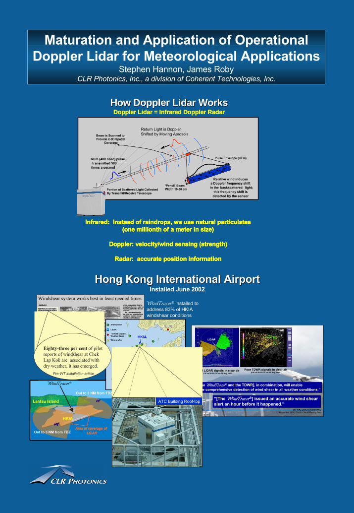
Maturation and Application of Operational Doppler Lidar for Meteorological Applications Stephen Hannon, James Roby CLR Photonics, Inc., a division of Coherent Technologies, Inc. Good LIDAR signals in clear air (1.8° at 20:33UTC on 16 Aug 2002) Poor TDWR signals in clear air (0.6° at 20:31UTC on 16 Aug 2002) “[The WindTracer ® and the TDWR], in combination, will enable more comprehensive detection of wind shear in all weather conditions.” “[The WindTracer ® ] issued an accurate wind shear alert an hour before it happened.” Dr. H.K. Lam, Director HKO 13 November 2002, South China Morning Post LIDAR TDWR How Doppler Lidar Works How Doppler Lidar Works Doppler Lidar = Infrared Doppler Radar Infrared: Instead of raindrops, we use natural particulates (one millionth of a meter in size) Doppler: velocity/wind sensing (strength) Radar: accurate position information How Doppler Lidar Works How Doppler Lidar Works Doppler Lidar = Infrared Doppler Radar Infrared: Instead of raindrops, we use natural particulates (one millionth of a meter in size) Doppler: velocity/wind sensing (strength) Radar: accurate position information Relative wind induces a Doppler frequency shift in the backscattered light; this frequency shift is detected by the sensor Pulse Envelope (60 m) ‘Pencil’ Beam Width 10-30 cm Portion of Scattered Light Collected By Transmit/Receive Telescope Return Light is Doppler Shifted by Moving Aerosols Beam is Scanned to Provide 2-3D Spatial Coverage 60 m (400 nsec) pulse transmitted 500 times a second Infrared: Instead of raindrops, we use natural particulates (one millionth of a meter in size) Doppler: velocity/wind sensing (strength) Radar: accurate position information Eight-three per cent of pilot reports of windshear at Chek ANGELA LI er, Dr. Lam said the Observa- tory planned bo buy a radar sys- tem using light rather than mi- crowaves. Dr. Lam claimed that the use of the new system had been considered when the present windshear and turbulence warning system was designed in the mid-1990s. “However, this was not done because no reliable sys- tem suitable for operational use was available in the market at that time,” he said. As the technology had re- cently matured and more reli- able systems were commercial- ly available, it was planned that the system be installed in 2002. Dr. Lam said that, on aver- age, 15 pilot reports of windshear were received by Eight-three per cent of pilot reports of windshear at Chek ANGELA LI er, Dr. Lam said the Observa- tory planned bo buy a radar sys- tem using light rather than mi- crowaves. Dr. Lam claimed that the use of the new system had been considered when the present windshear and turbulence warning system was designed in the mid-1990s. “However, this was not done because no reliable sys- tem suitable for operational use was available in the market at that time,” he said. As the technology had re- cently matured and more reli- able systems were commercial- ly available, it was planned that the system be installed in 2002. Dr. Lam said that, on aver- age, 15 pilot reports of windshear were received by Windshear system works best in least needed times Out to 3 NM from TDZ Out to 3 NM from TDZ Hong Kong International Airport Hong Kong International Airport Installed June 2002 WindTracer ® installed to address 83% of HKIA windshear conditions WindTracer ® Eighty-three per cent of pilot reports of windshear at Chek Lap Kok are associated with dry weather, it has emerged. ATC Building Roof-top TDWR TDWR Pre-WT installation article
Transcript of Maturation and Application of Operational Doppler Lidar ... · Maturation and Application of...
Maturation and Application of Operational Doppler Lidar for Meteorological Applications
Stephen Hannon, James RobyCLR Photonics, Inc., a division of Coherent Technologies, Inc.
Good LIDAR signals in clear air (1.8° at 20:33UTC on 16 Aug 2002)
Poor TDWR signals in clear air (0.6° at 20:31UTC on 16 Aug 2002)
“[The WindTracer® and the TDWR], in combination, will enable more comprehensive detection of wind shear in all weather conditions.”“[The WindTracer® and the TDWR], in combination, will enable more comprehensive detection of wind shear in all weather conditions.”
“[The WindTracer®] issued an accurate wind shear alert an hour before it happened.” “[The WindTracer®] issued an accurate wind shear alert an hour before it happened.”
Dr. H.K. Lam, Director HKO13 November 2002, South China Morning Post
LIDAR
TDWR
How Doppler Lidar WorksHow Doppler Lidar WorksDoppler Lidar = Infrared Doppler Radar
DopplerLidar
Relative wind inducesa Doppler frequency shiftin the backscattered light;
this frequency shift isdetected by the sensor
Pulse Envelope (60 m)
‘Pencil’ BeamWidth 10-30 cmPortion of Scattered Light Collected
By Transmit/Receive Telescope
Return Light is DopplerShifted by Moving AerosolsBeam is Scanned to
Provide 2-3D SpatialCoverage
60 m (400 nsec) pulse transmitted 500
times a second
Infrared: Instead of raindrops, we use natural particulates(one millionth of a meter in size)
Doppler: velocity/wind sensing (strength)
Radar: accurate position information
DopplerLidar
Relative wind inducesa Doppler frequency shiftin the backscattered light;
this frequency shift isdetected by the sensor
Pulse Envelope (60 m)
‘Pencil’ BeamWidth 10-30 cmPortion of Scattered Light Collected
By Transmit/Receive Telescope
Return Light is DopplerShifted by Moving AerosolsBeam is Scanned to
Provide 2-3D SpatialCoverage
60 m (400 nsec) pulse transmitted 500
times a second
Infrared: Instead of raindrops, we use natural particulates(one millionth of a meter in size)
Doppler: velocity/wind sensing (strength)
Radar: accurate position information
Eight-three per cent of pilot reports of windshear at ChekLap Kok are associated withdry weather, it has emerged.
However, the present warn-system works better when there is rain.
The system makes use of in-formation collected by aweather radar, which emits mi-
crowaves and detects the re-flections, to uncover wind-shear.
In August, a China Airlinesjet crashed at the new airportand overturned in flames, kill-ing three passengers and injur-ing 211 others on board.
The plane landing in heavy rain during a No 8 signal hoist-ed for Typhoon Sam, toucheddown on fire after the rightwing clipped the runway and was torn off. It h b t d th t
ANGELA LI er, Dr. Lam said the Observa-tory planned bo buy a radar sys-tem using light rather than mi-crowaves.
Dr. Lam claimed that the use of the new system had been considered when the present windshear and turbulence warning system was designedin the mid-1990s.
“However, this was notdone because no reliable sys-tem suitable for operationaluse was available in the marketat that time,” he said.
As the technology had re-cently matured and more reli-able systems were commercial-ly available, it was planned that the system be installed in2002.
Dr. Lam said that, on aver-age, 15 pilot reports of windshear were received by the Observatory each month.
Of these, 83 per cent are as-i t d ith d th
Windshear system works best in least needed times
Out to 3 NM from TDZ
Out to 3 NM from TDZ
Hong Kong International AirportHong Kong International AirportInstalled June 2002
WindTracer® installed to address 83% of HKIAwindshear conditions
WindTracer®
Eighty-three per cent of pilot reports of windshear at Chek Lap Kok are associated withdry weather, it has emerged.
ATC Building Roof-top
TDWRTDWR
Pre-WT installation article
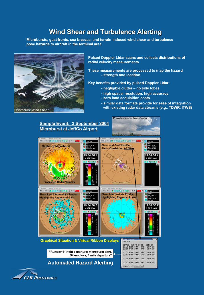
Automated Hazard Alerting
Wind Shear and Turbulence AlertingWind Shear and Turbulence Alerting
Pulsed Doppler Lidar scans and collects distributions of radial velocity measurements
These measurements are processed to map the hazard- strength and location
Key benefits provided by pulsed Doppler Lidar:- negligible clutter – no side lobes- high spatial resolution, high accuracy- zero land acquisition costs- similar data formats provide for ease of integration with existing radar data streams (e.g., TDWR, ITWS)
Sample Event: 3 September 2004 Microburst at JeffCo Airport
Processed Radial Velocity
Shear Line Intermediate ProductHighlighting Regions of Gain
Shear Intermediate Product Highlighting Regions of Loss
Shear and Gust IconifiedAlerts Overlaid on ARENAs
Center of Microburst
“Runway 11 right departure: microburst alert, 50 knot loss, 1 mile departure”
Microburst Wind Shear
Photo taken near time of event
Microbursts, gust fronts, sea breezes, and terrain-induced wind shear and turbulence pose hazards to aircraft in the terminal area
Graphical Situation & Virtual Ribbon Displays
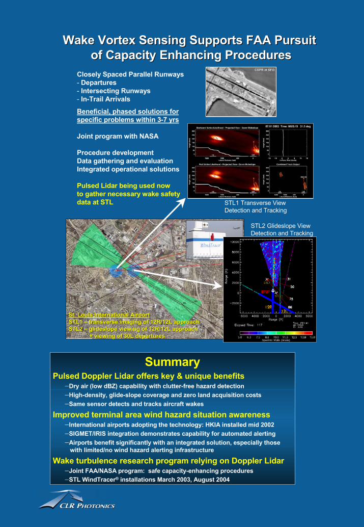
SummaryPulsed Doppler Lidar offers key & unique benefits
−Dry air (low dBZ) capability with clutter-free hazard detection −High-density, glide-slope coverage and zero land acquisition costs−Same sensor detects and tracks aircraft wakes
Improved terminal area wind hazard situation awareness−International airports adopting the technology: HKIA installed mid 2002−SIGMET/IRIS integration demonstrates capability for automated alerting−Airports benefit significantly with an integrated solution, especially those
with limited/no wind hazard alerting infrastructure
Wake turbulence research program relying on Doppler Lidar−Joint FAA/NASA program: safe capacity-enhancing procedures−STL WindTracer® installations March 2003, August 2004
Wake Vortex Sensing Supports FAA Pursuit Wake Vortex Sensing Supports FAA Pursuit of Capacity Enhancing Proceduresof Capacity Enhancing Procedures
Closely Spaced Parallel Runways- Departures- Intersecting Runways- In-Trail Arrivals
Beneficial, phased solutions for specific problems within 3-7 yrs
Joint program with NASA
Procedure developmentData gathering and evaluationIntegrated operational solutions
Pulsed Lidar being used nowto gather necessary wake safety data at STL
CSPR at SFOCSPR at SFO
St. Louis International AirportSt. Louis International AirportSTL1 STL1 –– transverse imaging of 12R/12L approachtransverse imaging of 12R/12L approachSTL2 STL2 –– glideslope glideslope viewing of 12R/12L approachviewing of 12R/12L approach
+ viewing of 30L departures+ viewing of 30L departures
STL1 Transverse ViewDetection and Tracking
STL2 Glideslope ViewDetection and Tracking