URBAN WATERFRONTS AND PLANNING FOR INDUSTRY
112
URBAN WATERFRONTS AND PLANNING FOR INDUSTRY Instructors: Anne Taufen, Ph.D., MGA J. Mark Pendras, Ph.D. Student Editor: Liza Higbee-Robinson Director of Urban Studies: Ali Modarres, Ph.D. SCHOOL OF URBAN STUDIES
Transcript of URBAN WATERFRONTS AND PLANNING FOR INDUSTRY

CHAPTER 2 | LAND, WATER, AND TRANSPORTATION USES | 1
URBAN WATERFRONTS AND PLANNING FOR INDUSTRY
Instructors: Anne Taufen, Ph.D., MGA J. Mark Pendras, Ph.D.
Student Editor: Liza Higbee-Robinson
Director of Urban Studies: Ali Modarres, Ph.D.
SCHOOL OF URBAN STUDIES

2 | UW URBAN STUDIES PROGRAM
We would like to acknowledge the generous investment of the following people, who shared time, insight, and ideas as we developed this work:
Kurt Beckett, Northwest Seaport Alliance
Deirdre Wilson, Northwest Seaport Alliance
John McCarthy, Tacoma Port Commission
Don Meyer, Tacoma Port Commission
Clare Petrich, Tacoma Port Commission
Emily Pinckney, Sustainable Tacoma Commission
Robb Krehbiel, Defenders of Wildlife
Meredith Neal, Tacoma-Pierce County Chamber of Commerce
Timothy Pinckney Glover, Pathways Education Training
Joel Baker, Center for Urban Waters
Melissa Malott, Citizens for a Healthy Bay
Nicole Faghin, Washington Sea Grant
Lynne Manzo, UW Seattle College of Built Environments
Matt Seto, UW Tacoma Community Partnerships
Emma Slager, UW Tacoma Urban Studies
This included meeting with students, attending a mid-project presentation, providing interviews, and sharing technical expertise and recommendations.
There are many others that we would like to include in a next-stage project. While the excellent contributions of the community members and civic leaders listed above are essential to the findings that follow, any mistakes or misinterpretations are ours.MA IN COMMUNITY PLANNING CLASS OF 2019
ACKNOWLEDGEMENTS

INTRODUCTION | 3
The Community Planning program and the School of Urban Studies are committed to the potential of academic research to further community interests. In a process of investigation and co-learning, students, faculty, and local partners work to foreground issues and connections that provide opportunities for shared growth and equitable development. In a region that is seeing substantial investment and population increase, there are also widening disparities among different demographic groups, stubborn overall poverty rates, and stagnant or deteriorating environmental conditions (PSRC 2017). These realities require deeper, community-oriented research, analysis, and action. A clearer understanding of the complex challenges facing working waterfronts and the communities they serve will enable local leaders to work proactively with stakeholders, to build strong constituencies for investment, innovation, resource protection, and sustainable growth.
This report contains work produced by the 2019 MACP cohort for their culminating studio project. The culminating studio is a two-term (20-week) course intended to enable students to apply the lessons from their MACP courses to an important community-based project. For 2019, that project was Urban Waterfronts and Planning for Industry.
URBAN WATERFRONTS AND PLANNING FOR INDUSTRY
FALL 2019

4 | UW URBAN STUDIES PROGRAM
THE 2019 STUDIO AND THIS REPORT FOREGROUND TWO MAIN ISSUES. First, WE NEED INDUSTRY. The jobs and economic prosperity that are created through industrial development are essential to the sustainability of this region. People need reliable, living-wage employment in order to provide for themselves and their loved ones; contribute to the local housing, service, and retail economies; make use of their intrinsic capacities; and give back to the communities of which they are a part. Industry is the act of working hard, as well as a certain kind of production and manufacturing economy. People in the South Sound want and need to work. Industry is a big part of this region’s past – and for sustainable urban development, it is also our future.
Second, WE NEED A SHARED VISION for industrial development that respects, responds to, and sustains communities throughout the city and region. The tideflats and the deep water port are shared public assets. Yesterday’s industry will not necessarily support and protect the values that future generations rely upon, as we look to cleaner, innovative, broadly lucrative forms of growth. Elected officials and civic leaders must improve their ability to work with local constituencies, to build shared commitments around the use of resources and creation of opportunities that serve long-term investments in a healthy and prosperous region.
This project grew out of the convergence of research interests from the co-instructors (Anne Taufen and Mark Pendras) and emerging tensions and development related to urban industrial planning on Tacoma’s waterfront.
Ultimately, the students worked in teams of 2-3 to address these challenges; their findings are found in the following chapters, and described in some detail below. This introduction provides background and context on the need for industrial planning and sustainable waterfront development,
INTRODUCTION
in Tacoma and elsewhere, as well as offering perspective on the costs of failing to sufficiently engage local community constituencies in these investments and decision-making. At the end of this chapter we offer suggestions for next steps that can move the Port, the Tribe, the City, and local stakeholders forward in this regard.
TIMELINE
FALL 2018
Preliminary outreach, Tacoma Port Commission and NW Seaport Alliance
WINTER 2019
Initial literature review and project team formation
Issue analysis and policy briefs, project proposals
SPRING 2019
Final project teams and draft scope of work set
APRIL 2019
Feedback session with partners, Center for Urban Waters
MAY 2019
Work in individual project teams
JUNE 2019
Public presentation, UW Tacoma

INTRODUCTION | 5
ARE INDUSTRIAL WATERFRONTS IMPORTANT TO COMMUNITY PLANNING? YES.The goal of this project is to envision and situate manufacturing and industry as key components of Tacoma’s sustainability goals, and in particular the need to support work, environmental equity, and economic innovation as community development in the South Sound. The literature and research are clear; waterfronts are shared public resources, and industrial development is crucial for shared prosperity in urban regions.
Dr. Taufen’s research focuses on the urban waterfront as a regional asset, essential to the social and ecological systems of which it is a part. Land use decisions on the urban waterfront have durable and far-reaching effects, benefiting some interests and often excluding others in ways that persist – and potentially preclude new forms of growth and innovation.
Dr. Pendras’s research on how and why cities create and maintain space for urban industry and why industrial planning is especially important in ‘regional second cities’ like Tacoma, fueled an interest in exploring and contributing to the current moment of industrial rethinking on Tacoma’s urban waterfront. Early conversations with Kurt Beckett, Deputy CEO of the Northwest Seaport Alliance, and Port of Tacoma Commissioners Don Meyer and John McCarthy, confirmed local interest in engaging students in exploratory research on the topic.
The concept of ‘exploration’ is especially apt here: the project as envisioned was, intentionally, loosely defined and only informally connected with any particular organization, group, agency, or constituency. The key strength of this approach was that it enabled the studio course to focus on a topic (urban industrial planning) that is both of strategic importance to cities and yet simultaneously poorly understood and widely overlooked by planners and development practitioners. In other words, the studio could pursue new knowledge of scholarly
and practical importance that might not otherwise have been requested by any particular local group. That strength was accompanied by several challenges. First, the scholarship on industrial planning, particularly on urban waterfronts, is compelling but relatively thin, which again reflects the need for additional attention to the topic but also limits the guidance available from existing scholarship. Second, while students were encouraged to conduct research in ways that were informed and inspired by scholarship, the lack of formal connection to specific local constituencies introduced a level of uncertainty regarding local relevance and applicability. Finally, these challenges were heightened by the fact that ‘urban industrial planning’ is increasingly contentious and in many ways divisive, especially in Tacoma at this moment in time as different visions for Tacoma’s future compete for support. Students were thus tasked with navigating a new area of inquiry without the benefit of an obvious charge from an established body of scholarship or a local community of practitioners and under conditions of political tension and uncertainty. Navigating these tensions was no easy task and the students deserve recognition for their patience, perseverance, and professionalism.
The studio and report focus attention on the east side of the Thea Foss Waterway, as a symbolic space that reflects some important urban industrial and port/city tensions, which will be discussed briefly below. Located just outside the downtown Tacoma urban core and commercial waterfront, the East Thea Foss, as it is referred to in this report, constitutes a buffer and transitional zone from the heavy industrial and maritime uses of the Port and the light industrial, commercial, and residential land uses of the city. Within the context of urban waterfronts and industrial planning, the task for this studio was to consider how the East Thea Foss might fit within broader visions for the future of industry in the port tideflats subarea.
PROJECT BACKGROUND

6 | UW URBAN STUDIES PROGRAM
HOW COULD COMMUNITY PLANNING HELP TACOMA’S INDUSTRIAL FUTURE?
BUILDING INCLUSIVE, INFORMED CONSTITUENCIES FOR INDUSTRIAL GROWTH AND SUSTAINABLE INNOVATION.In April of 2016, after a nearly two-year process that ranged from courtship to controversy to collapse, a proposal to build what would have been the largest methanol plant in the world in the Port of Tacoma, WA, was canceled. That cancellation was closely followed by heightened and renewed tensions over a proposed liquefied natural gas (LNG) plant, interim regulations imposing a moratorium on new industrial land uses in the Port, and the announcement of a new sub-area planning process to review the Port’s land use and zoning designations. These developments capture and symbolize the currently evolving landscape of industrial planning on the Tacoma waterfront, a landscape that is emblematic of the tensions many cities face as they attempt to chart their industrial and economic futures. A brief engagement with urban industrial history can help provide some context for these tensions.
For the past several decades, cities in the United States (and other industrialized nations) have struggled to cope with the challenges of deindustrialization and industrial transition. In cities with traditionally strong industrial bases (Detroit, MI; Buffalo, NY; Gary, IN; Youngstown, OH) the transition to a service and information-based economy has been especially difficult (Bluestone and Harrison, 1982; Wolman, et al, (2015). Other cities (San Francisco, CA; Los Angeles, CA; Austin, TX; Seattle, WA), with broader industrial histories and more established foundations in professional services, have been well-positioned to absorb investments redirected to other sectors and industries (Shaw, 2001). Yet, regardless of individual industrial histories, the processes of deindustrialization
and postindustrial transition have resulted in a substantial shift in the character of urban politics and development and, consequently, in urban social conditions across most, if not all, US cities. Under the current post-industrial policy framework, conventional wisdom suggests that in order for cities to secure any positive economic future they must compete for the ‘jobs of the future’ in such sectors as high-technology, bio-technology, and FIRE (finance, insurance, and real estate).
These general trends towards deindustrialization found special expression in port cities, as shipping and transportation innovations transformed the configuration, operation, and location of port activities world-wide. In particular, containerization transformed ports from goods processors—which entailed significant manufacturing and assembly work in addition to the transportation of goods—into primarily goods distributors (Hoyle 2000). As goods distributors, ports became more focused on the logistics of moving goods from one place to another, the dock and yard space needed for proper cargo handling, and the infrastructure required to carry out their distributive function (Hall 2009). There is much more to say about this transformation of ports; but for the purposes of the present project, the point is that such transformations resulted in several important trends: 1) ports needed fewer workers to carry out their goals, 2) ports became increasingly connected with the distant locations to and from which goods were being distributed (and, consequently, less connected to their ‘home’ locations), and 3) increasingly specialized technological andgeographic requirements meant fewer portscould effectively compete in the new world of portoperations, resulting in port reductions, closures,and consolidations (Brown 2009, Hall 2009, Hein2011). Those ports, such as the Port of Tacoma,that effectively weathered this transition andremained vibrant within the new landscape of portcompetition did so in a context of a fundamentally
PROJECT CONTEXT

INTRODUCTION | 7
altered historic port/city relationship. In short, the new demands on ports introduced new tensions with their associated cities and residents as ports reduced hiring and increased demands and pressures on local built and natural environments in order to compete globally.
Though the Port of Tacoma successfully navigated the economic and technological patterns of deindustrialization and port transition in recent decades, the failure to fully engage local constituencies and demonstrate benefits of global trade networks has taken on greater salience. South Sound residents have become more vocal about the use and beneficiaries of the port-area tideflats, and the emerging tensions and conflicts reflect the extent to which the costs of these global pressures are becoming more pronounced (and less tolerable) locally. Tacoma has maintained an economy and ‘gritty’ identity on the foundation of port industrial strength, but new concerns about the environmental and opportunity costs associated with that development path have inspired new questions about future possibilities.
The context of deindustrialization, port competition, and economic change might suggest that the time is right for Tacoma to distance itself from its industrial past and instead to embrace and invest in a postindustrial future. The current project rejects that conclusion for the following reasons:
INDUSTRIAL VIABILITYDespite the finality implied by the term ‘deindustrialization’, a preponderance of recent research emphasizes the importance of heavy industry and manufacturing to urban economies (Ferm and Jones, 2016; Lester, Kaza, and Kirk, 2013; Luria and Rogers, 2007; Curran, 2007). Changing economic conditions have certainly raised new challenges for industrial interests, but equally challenging have been changing political conditions that disadvantage ‘producers’ in favor of spaces of ‘consumption’. With land uses connected to
professional services coming in on such a strong tide, many city planners have been reluctant to mount a counter-tidal defense of industrial activity and have consequently done a poor job of maintaining space for urban industrial production. This ‘blind side’ of planning has unnecessarily eroded support for industry (Leigh and Hoelzel, 2012). With the proper care, planning, and nurturing, urban industries can remain viable and make significant contributions to urban economies.
SOCIAL JUSTICE The steady disintegration of industrial jobs over the past forty years has contributed significantly to economic polarization and social exclusion in US cities (Parker and Rogers, 2001; Hamnett, 2000), as relatively stable, well-paid employment opportunities, with clear job-ladders and the potential for social mobility, for individuals with relatively little formal education or training, have dwindled (Bluestone and Harrison, 1982; Luria and Rogers, 2007). As these jobs have declined and been replaced by the simultaneous expansion of professional services positions beyond the reach of most of this class of worker or else by low-wage service jobs that offer no benefits and little opportunity for growth or advancement, it is not surprising to see cities struggling with social justice questions. Industrial jobs continue to provide job opportunities that can help confront social and economic polarization.
URBAN SUSTAINABILITY There is no question that a long history of unregulated heavy industry has contributed to a toxic legacy that continues to compromise the health and safety of urban environments. Nevertheless, urban industrial futures need not mirror industrial pasts. Improved production technologies (embedded in the concept of ‘Industry 4.0’, discussed in Chapter 7) enable cleaner

8 | UW URBAN STUDIES PROGRAM
production methods, with fewer environmental externalities. Furthermore, ‘deindustrialization’ in the United States has never implied a reduced reliance on industrial production. On the contrary, the production and consumption of industrially produced goods has increased exponentially in recent decades (Samuelson, 2013; Federal Reserve, 2019; Naim, 2014); what has changed is the location of industrial production. Maintaining local industrial production is one way to maintain awareness of and responsibility for the goods being produced. Doing so, however, will require planners to confront overly simplistic assumptions about what constitutes urban sustainability and to consider the role of industry in planning for ‘smart growth’ (Leigh and Hoelzel, 2012).
The project also points relentlessly towards the need for improved trust, communication, and understanding between the constituencies involved in port sub-area planning. The people whose taxes and local environmental resources are being allocated to industrial development investments, need to be reasonably resigned to the trade-offs, possibilities, and challenges involved. It is not for the policy makers to independently pursue new industrial fixes; for support to be stable and implementation to be successful, local communities must be connected to and involved in the process (Pressman and Wildavsky 1973, 1984). While this is a longstanding area of interest and emphasis for planners (Arnstein 1969, Forester 1989, Healey 1997, Forester 1999), there are no easy answers when it comes to building institutional and interpersonal networks of inclusion, learning, and reciprocity (Quick and Feldman 2011).
The work conducted by MACP students in this studio project started from an assertion that maintaining space for industry on Tacoma’s urban waterfront is desirable; different groups then identified and pursued research plans that explored different dimensions of urban industrial planning relevant to the specific Tacoma context.
PROJECT CONTEXT (CONTINUED)
CHAPTER ONE INSTITUTIONAL ARRANGEMENTSReviews the intersecting rights and responsibilities of the Port of Tacoma, Puyallup Tribe of Indians, and City of Tacoma in the tideflats
CHAPTER TWO LAND, WATER, AND TRANSPORT USEDocuments land use, transport, water use, and property use on the East Side of the Thea Foss Waterway
CHAPTER THREE PLACE ATTACHMENT IN RELATION TO URBAN WATERFRONTS AND PLANNING FOR INDUSTRYShows how community-focused emotions, behaviors, and cognitions of place attachment influence industrial development
CHAPTER FOUR HISTORICAL TENSIONS: MOVING FORWARD WITH PUBLIC SUPPORTIdentifies conflict themes that have repeatedly surfaced over time with respect to development in the tideflats
CHAPTER FIVE PUBLIC ACCESS AND INDUSTRIAL SHORELINESExplores co-existence of industrial shoreline use and public waterway access
CHAPTER SIX ECONOMIC DEVELOPMENTDefines and promotes Industry 4.0 as a great opportunity for the Port of Tacoma – cleaner, more equitable, more sustainable
CHAPTER SEVEN ENVIRONMENTAL HEALTHIdentifies actionable projects to counter environmental gentrification through stewardship, opportunity, inclusion, awareness
FOR THIS REPORT, THE STUDENT RESEARCH PROJECTS HAVE BEEN ORGANIZED INTO THE FOLLOWING CHAPTERS:

INTRODUCTION | 9
ONE
While each chapter explores a unique dimension of industrial planning on the Tacoma tideflats, several recurring themes that unite the chapters are worth noting:Creating and maintaining space for urban industry is central to the vision for sustainability advanced by this report. Displacing industrial production from the urban landscape does not reduce local demand for or reliance on heavy industry; it just renders such practices invisible. Maintaining local industrial production encourages ownership of and responsibility for industrial practices while simultaneously preserving middle income jobs that provide opportunities for social and economic mobility. (Economic Development; Environmental Health)
TWO
Despite the benefits of maintaining urban industry, damaging environmental legacies and ongoing negative perceptions of industry fuel distrust and resistance among local populations. Industrial advocates must therefore acknowledge and address the historical tensions that shape planning interests in the port subarea. Ignoring or avoiding such tensions will undermine industrial planning efforts; instead this report highlights the importance of visible efforts to confront the problems of the past and to invest in more socially, environmentally, and economically productive futures. (Place Attachment; Historical Tensions; Public Access)
THREE
Engaging community stakeholders, understanding shared future needs, and building strong
constituencies for industrial land use and development are essential to supporting maritime industrial economies, and protecting the natural resources of the region. Civic engagement is not a matter of pushing out information and gathering public comments; it is an ongoing investment in shaping a shared vision for growth that includes and supports people throughout the city and region. Sustainable programs and projects provide opportunities for continual learning on all sides; foreground the interests of tribal, African-American, and immigrant constituencies; build stable and visible industrial employment options for women; and create child-centered spaces and activities (Institutional Arrangements; Land, Water, and Transport Use)
The MA program in Community Planning conducts academic research to serve community interests. The 2019 studio and this report indicate important areas for additional study and focused investment, to better steward this shared place.
The Commencement Bay tideflats are a significant regional resource that has helped to define the Puget Sound culturally, economically, environmentally, and socially. Many communities have a stake in its future. As understandings are built and planning decisions are made, there are ways in which research and collaboration can help. With targeted support, the School of Urban Studies and its programs in community planning, geospatial science, urban design, and sustainable urban development can build upon this preliminary studio, potentially in collaboration with other units on campus (Engineering, Business, Environmental Science and others).
KEY POINTS
10 | UW URBAN STUDIES PROGRAM
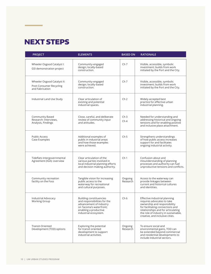
NEXT STEPS
Wheeler Osgood Catalyst I:
GSI demonstration project
Community-engaged design; locally-based construction.
Ch 7
Ch 7
Ch 2
Ch 3
Ch 4
Ch 5
Ch 1
Ch 6
Ongoing Research
Ongoing Research
Visible, accessible, symbolic investment; builds from work initiated by the Port and the City.
PROJECT ELEMENTS RATIONALEBASED ON
Transit-Oriented Development (TOD) options
Exploring the potential for transit oriented development to support industrial activities.
To ensure social and environmental gains, TOD can be extended beyond commercial and residential developments to include industrial sectors.
Wheeler Osgood Catalyst II:
Post-Consumer Recycling and Fabrication
Community-engaged design; locally-based construction.
Visible, accessible, symbolic investment; builds from work initiated by the Port and the City.
Industrial Land Use Study Clear articulation of existing and potential industrial spaces.
Widely accepted best practice for effective urban industrial planning.
Community Based Research: Interviews, Analysis, Findings
Close, careful, and deliberate review of community input and attitudes.
Needed for understanding and addressing historical and ongoing tensions and for enabling positive and inclusive place attachment.
Public Access Case Examples
Additional examples of public in industrial areas and how those examples were achieved.
Strengthens understandings of how public access increases support for and facilitates ongoing industrial activity.
Tideflats Intergovernmental Agreement (IGA): overview
Clear articulation of the various parties involved in local industrial planning efforts and decision making authority.
Confusion about and misunderstanding of planning processes and authority can fuel unproductive tensions and conflicts.
Community recreation facility on the Foss
Tangible vision for increasing public access to the waterway for recreational and cultural purposes.
Access to the waterway can provide linkages between current and historical cultures and identities.
Industrial Advocacy Working Group
Building constituencies and responsibilities for the advancement of industry on Tacoma’s waterfront; enabling a productive industrial ecosystem.
Effective industrial planning requires advocates to take ownership and responsibility for facilitating connections and relationships and for articulating the role of industry in sustainable, creative, and inclusive cities.

INTRODUCTION | 11
The Master of Arts in Community Planning degree is designed to develop civic leaders who are equipped to make change in networks of public and private actors, helping to create more just, sustainable, and livable urban futures. This degree is premised on the following ideas:
1. “Community” is not a singular concept; moreover, less visible and under-resourced urban publics are often in need of specific forms of investment andsupport in order to engage the political process;
2. “Planning” is about enacting urban socio-spatial futures, through a varietyof different professional roles; as such it happens in a number of differentorganizational settings and job titles;
3. The ways that people act and the social structures within which they are ableto act are co-constituted; one creates and re-creates the other, and effectivechange agents use existing structures to generate new forms of action, and/ortake singular, strategic actions to enable, demand, or elicit structural change.
Graduates will be prepared to be competent collaborative professionals who work with and empower community constituents, influencing processes of policy formation, resource generation, community change, and urban development. The program’s emphasis on urban social issues, community development, and urban problem solving, and its commitment to training students to think critically and creatively, to work collaboratively in the interest of creating sustainable communities and to effectively communicate knowledge in a variety of ways is a direct expression of the UW Tacoma mission as a higher education institution.
MACP PROGRAM OVERVIEW

12 | UW URBAN STUDIES PROGRAM | HIGBEE-ROBINSON, HILTON, AND STEPHENS

CHAPTER 1 | INSTITUTIONAL ARRANGEMENTS | 13
Failed efforts to construct the world’s largest methanol plant in the local tideflats exposed need for the Port of Tacoma to become more transparent in its pursuits. The event acted as a catalyst for the City of Tacoma to initiate the Tideflats Subarea planning process. The Tideflats Subarea Plan will direct future management and development of the tideflats area. The planning process is designed to be inclusive of and responsive to local governments and their constituencies.
This chapter provides a general understanding of how the rights and responsibilities of various government institutions intersect within the tideflats area, including their arrangement around the Tideflats Subarea planning process. Two phases of research have contributed to the findings presented in this chapter. During phase I, we studied the legal and development history of the tideflats area. During Phase II, we shifted our focus to understanding the rights and responsibilities of three key institutions involved in developing the Tideflats Subarea Plan: the City of Tacoma, the Puyallup Tribe of Indians, and the Port of Tacoma. We considered their roles in view of federal- and state-level policies of relevance to tideflats/port management and development. From our work researching and describing the rights and responsibilities of these institutions, we produced two organizational charts: one to convey broad powers and relationships among key institutions, and another to represent the actors and stages involved in the Tideflats Subarea planning process.
By: Liza Higbee-Robinson, Jeffrey Hilton, and Rhasean Stephens
INSTITUTIONAL ARRANGEMENTS
ABSTRACT
CHAPTER 1
FALL 2019
14 | UW URBAN STUDIES PROGRAM | HIGBEE-ROBINSON, HILTON, AND STEPHENS
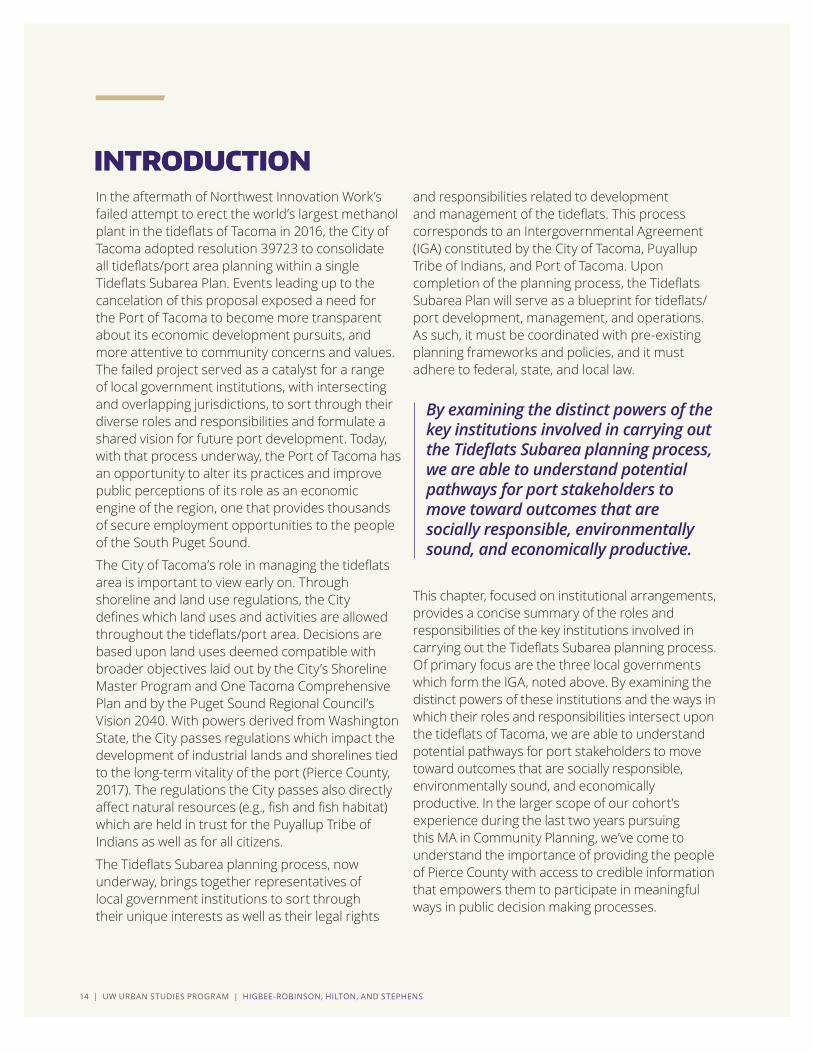
In the aftermath of Northwest Innovation Work’s failed attempt to erect the world’s largest methanol plant in the tideflats of Tacoma in 2016, the City of Tacoma adopted resolution 39723 to consolidate all tideflats/port area planning within a single Tideflats Subarea Plan. Events leading up to the cancelation of this proposal exposed a need for the Port of Tacoma to become more transparent about its economic development pursuits, and more attentive to community concerns and values. The failed project served as a catalyst for a range of local government institutions, with intersecting and overlapping jurisdictions, to sort through their diverse roles and responsibilities and formulate a shared vision for future port development. Today, with that process underway, the Port of Tacoma has an opportunity to alter its practices and improve public perceptions of its role as an economic engine of the region, one that provides thousands of secure employment opportunities to the people of the South Puget Sound.
The City of Tacoma’s role in managing the tideflats area is important to view early on. Through shoreline and land use regulations, the City defines which land uses and activities are allowed throughout the tideflats/port area. Decisions are based upon land uses deemed compatible with broader objectives laid out by the City’s Shoreline Master Program and One Tacoma Comprehensive Plan and by the Puget Sound Regional Council’s Vision 2040. With powers derived from Washington State, the City passes regulations which impact the development of industrial lands and shorelines tied to the long-term vitality of the port (Pierce County, 2017). The regulations the City passes also directly affect natural resources (e.g., fish and fish habitat) which are held in trust for the Puyallup Tribe of Indians as well as for all citizens.
The Tideflats Subarea planning process, now underway, brings together representatives of local government institutions to sort through their unique interests as well as their legal rights
and responsibilities related to development and management of the tideflats. This process corresponds to an Intergovernmental Agreement (IGA) constituted by the City of Tacoma, Puyallup Tribe of Indians, and Port of Tacoma. Upon completion of the planning process, the Tideflats Subarea Plan will serve as a blueprint for tideflats/port development, management, and operations. As such, it must be coordinated with pre-existing planning frameworks and policies, and it must adhere to federal, state, and local law.
This chapter, focused on institutional arrangements, provides a concise summary of the roles and responsibilities of the key institutions involved in carrying out the Tideflats Subarea planning process. Of primary focus are the three local governments which form the IGA, noted above. By examining the distinct powers of these institutions and the ways in which their roles and responsibilities intersect upon the tideflats of Tacoma, we are able to understand potential pathways for port stakeholders to move toward outcomes that are socially responsible, environmentally sound, and economically productive. In the larger scope of our cohort’s experience during the last two years pursuing this MA in Community Planning, we’ve come to understand the importance of providing the people of Pierce County with access to credible information that empowers them to participate in meaningful ways in public decision making processes.
By examining the distinct powers of the key institutions involved in carrying out the Tideflats Subarea planning process, we are able to understand potential pathways for port stakeholders to move toward outcomes that are socially responsible, environmentally sound, and economically productive.
INTRODUCTION

CHAPTER 1 | INSTITUTIONAL ARRANGEMENTS | 15
PORT OF TACOMA (Port) A public port authority enabled by the Washington State Port District Act (Title 53) of 1911, and establishedin 1918 by the vote ofresidents of Pierce County.The Port is governed byfive elected Commissionersand can provide facilitiesfor marine transportationand trade; develop lands forindustrial and commercialuses; provide economicdevelopment programs; buy,lease, and sell properties;provide air and waterpollution control facilities;operate trade centers andexport trading companies;establish and operate foreigntrade zones; and promotetourism (Port of Olympia,n.d.). The Port of Tacomaowns 2,500 acres of landthroughout CommencementBay’s tideflats and is a major economic driver andemployment source in theSouth Puget Sound.
TIDEFLATS AREA (Tideflats, Port) Refers to a geographical area which includes natural deepwater harbors of Commencement Bay and industrial lands which adjoin with the Hylebos Waterway, Blair Waterway, Sitcum Waterway, Puyallup River, Saint Paul Waterway, Middle Waterway, and Thea Foss Waterway (Port of Tacoma, 2014). The jurisdictions of the City of Tacoma, City of Fife, and Pierce County intersect within the tideflats and overlap with Puyallup tribal lands (Port of Tacoma, 2014).
TIDEFLATS MANUFACTURING AND INDUSTRIAL CENTER (MIC) A regional planning designation attributed to the tideflats/port area by the Puget Sound Regional Council in its Vision 2040. The MIC is planned to accommodate substantial employment growth and to protect manufacturing and industrial uses from encroachment by other sectors. Owing to the port’s regional importance for trade, commerce, and employment, the MIC will be prioritized to receive funding for transportation projects. The MIC includes a “core area,” zoned for heavy industrial and manufacturing uses; and transitional “buffers,” zoned for light industrial and commercial uses (City of Tacoma, 2017). The East Thea Foss is included within the transitional buffer zone.
TIDEFLATS SUBAREA Like the MIC, this term applies to the tideflats/port area, linking it to the ongoing Tideflats Subarea planning process being carried out by the City of Tacoma, Port of Tacoma, Puyallup Tribe of Indians, City of Fife, and Pierce County. The creation of the Tideflats Subarea (and related Tideflats Subarea Plan) is crucial not only for maintaining the tideflats’ status as an MIC, which enables the area to receive prioritization for transportation funding in the future, but also for bringing this assortment of government institutions together for the first time to coordinate their distinct rights and responsibilities around a shared planning process.
The following summaries clarify the usage of related terms found throughout this chapter: Port of Tacoma (Port), Tideflats Area (tideflats, port), Tideflats Manufacturing and Industrial Center (MIC), and Tideflats Subarea.
KEY TERMS

16 | UW URBAN STUDIES PROGRAM | HIGBEE-ROBINSON, HILTON, AND STEPHENS
During our initial research phase, we investigated the legal and development history of the tideflats/Port of Tacoma. We learned about the years and decades leading up to the Port of Tacoma’s establishment as a public port authority in 1918, as well as how the port has been defined since. We considered the intergovernmental relationship between the Port of Tacoma and the City of Tacoma and we investigated the historical significance of tribal land claims in view of key tensions between the Puyallup Tribe of Indians and other local government institutions. We identified specific regulatory mechanisms in place which both enable and restrict port development, and which require environmental management and public access provisions.
In our second phase of research, we focused on identifying what different governmental institutions are enabled and required to do through law, and how their powers intersect within the tideflats area. Then, we applied our understandings, focusing on the involvement of the City of Tacoma, the Puyallup Tribe of Indians, and the Port of Tacoma, in the ongoing Tideflats Subarea planning process. Our second phase of research enabled us to create two organizational charts. One represents the broad powers of the US federal government,
Puyallup Tribe of Indians, City of Tacoma, and Port of Tacoma. The second situates the powers of the City of Tacoma, Puyallup Tribe of Indians, and Port of Tacoma in view of the Tideflats Subarea planning process. We view this planning process as a live case for studying how these institutions organize themselves amongst one another to achieve a common purpose, to establish a coherent trajectory for the tideflats/port that adheres to law and supports the objectives of broader planning frameworks, such as the Puget Sound Regional Council’s Vision 2040.
Over the course of our study process, we have gathered information from articles, planning documents, policy manuals, and government websites. At various points, we have presented findings and received feedback from peers, faculty, and tideflats/port stakeholders. This feedback has enabled us to refine our approach and to sharpen our focus on identifying the institutional arrangements involved with tideflats/port development and management. Our overarching goal has been to create both written material and graphical representations which can be used to educate broad public audiences on the roles and responsibilities of different government agencies involved in the Tideflats Subarea planning process.
RESEARCH OVERVIEW
Two primary phases of research have contributed to the study results and key findings presented in this chapter.
PHASE I
Research on the legal and development history of the port/tideflats of Tacoma
PHASE II
Research and analysis of the legal authorities and responsibilities of four key institutions (the US federal government, the City of Tacoma, the Puyallup Tribe of Indians, and the Port of Tacoma)

CHAPTER 1 | INSTITUTIONAL ARRANGEMENTS | 17
We have applied our understandings of each institution’s legal authority to the ongoing Tideflats Subarea planning process. In doing so, we have captured how the distinct roles and powers of each institution necessarily intersect in creating a plan that will guide the tideflats/port area into the future.
STUDY RESULTS AND KEY FINDINGS
This section focuses on the authorities of four public institutions, whose powers both constrain and enable management and development practices for the tideflats/port of Tacoma: the US federal government, the Puyallup Tribe of Indians, the City of Tacoma, and the Port of Tacoma. For each institution, we’ve contemplated three questions:
ONE
From where does each institution derive its power to influence management/development of the tideflats/port of Tacoma?
TWO
What broad powers does each institution possess regarding management/development of the tideflats/port area?
THREE
How do their roles and powers merge and intersect?

18 | UW URBAN STUDIES PROGRAM | HIGBEE-ROBINSON, HILTON, AND STEPHENS
The federal policies described in this section by no means stand as a comprehensive set. However, the two acts listed below have shown their effect in terms of drastically changing how land use decisions are made locally. All planning and development which occurs in the tideflats/port area must adhere to the following federal policies.
CLEAN AIR ACT
The Clean Air Act (CAA), passed in 1963 and amended in 1970 and 1990, is intended to guard public health against exposure to various air contaminants. It sets up air quality standards and requires states and local governments to enforce policies and regulations to adhere to those standards. Local port operations must comply with the CAA; this impacts a variety of activities, from the kind of motors and paint coatings permitted, to the levels and kinds of discharges allowed from vehicles (Port of Tacoma, 2019). Related to complying with the CAA, in 2008, the Ports of Tacoma and Seattle, along with the Port of Vancouver, BC, adopted the Northwest Ports Clean Air Strategy to reduce maritime and other port-related emissions known to contribute to unhealthy air and climate change (Port of Seattle, Port of Tacoma, and Vancouver Port Authority, 2018). This intervention marks the first international effort of its kind. CLEAN WATER ACT
The Clean Water Act (CWA) establishes the basic structure for regulating the discharge of pollutants into US water bodies and outlines surface water and groundwater quality standards. Section 404 of the Clean Water Act (CWA) regulates the release of dug and fill material into waters of the United States, which include wetlands. Section 404 requires permittees to file for a license prior to releasing any dug or fill material into waterways, excluding actions which are absolved from Section 404, which include certain cultivation and ranger service activities.
The Washington State Department of Ecology requires the City of Tacoma to produce a Stormwater Management Program (SWMP) to
regulate the discharge of stormwater into local surface waters and groundwaters (City of Tacoma Environmental Services, 2017). The Port of Tacoma, as a secondary permittee of the SWMP, is required to abide by fewer requirements than the City but should also produce its own Stormwater Management Plan (City of Tacoma Environmental Services, 2017). THE US ARMY CORPS OF ENGINEERS
The US Army Corps of Engineers is the permitting authority for the waters of the Port of Tacoma, which fall within US boundaries. This authority is granted by the Rivers and Harbors Act of 1899 (US Fish and Wildlife Service, n.d.). In relation to the Port, the US Army Corps of Engineers’ ecological mission has two primary focuses: reclamation and stewardship. By federal regulation, the US Army Corps of Engineers is responsible for the restoration and management of various ecological resources. Efforts range from revitalizing contaminated sites previously used for military purposes to restoring wetlands and other ecologically sensitive areas (Carter and Stern, 2017).
US Army Corps of Engineers responsibilities:
• Enforce Section 404 of the Clean Water Act • Administer day-to-day program • Oversee individual and general permit decisions • Conduct or verify jurisdictional determinations • Develop policy and guidance
The US Environmental Protection Agency (EPA) and US Army Corps of Engineers accord with the 1987 Corps of Engineers Wetlands Delineation Manual to distinguish wetlands for the CWA Section 404 license program. The Manual distinguishes the natural features of a wetland by soil typology, plant species, and hydrology.
UNITED STATES FEDERAL GOVERNMENT

CHAPTER 1 | INSTITUTIONAL ARRANGEMENTS | 19
MARITIME READINESS
The Maritime Administration (MARAD) is an agency within the US Department of Transportation (DOT) which oversees waterborne transportation, including its integration with other segments of the transportation system (Maritime Administration, 2018). MARAD’s purpose is to develop, promote, and direct the US Maritime Service and US Merchant Marine. Its programs involve ships, shipping, shipbuilding, port operations, vessel operations, national security, public safety, and the environment.
MARAD is one of nine members of the National Port Readiness Network (NPRN) responsible for securing the movement of military forces through US ports (Maritime Administration, 2018). Since its establishment in 1994, NPRN has “encourage[d] the exchange of deployment information between military personnel responsible for the logistics of moving a unit and the unit itself” (Bureau of Transportation Statistics, Maritime Administration, and US Coast Guard, 1999). This information sharing is key to identifying lift requirements, determining port capabilities, designating cargo
staging areas, and evaluating potential impacts of commercial disruption as a result of activating ports for military forces.
The federal Strategic Seaport Program represents collaborative efforts of the US Department of Defense (DOD) and the Department of Transportation (DOT). The Program manages the deployment of military forces through a set of designated strategic seaports (US Government Accountability Office, 2013). Within the Marine Ports and Navigation Plan (2017), the Washington State Department of Transportation (WSDOT) highlights the importance of the Port of Tacoma as one of 17 commercial seaports with a “strategic seaport” designation. As a strategic seaport, the Port of Tacoma must be prepared to make its facilities available for the deployment of military forces with minimal notice and with measures in place to minimize commercial disruption.
The Port of Tacoma has established directives with the military to ensure port readiness. Terminals Tariff No. 300 states that “[w]hen the Ports and or Alliance are notified…that a Military Service exercise will require Terminal space not under lease, the Ports and Alliance will vacate said space.” All associated costs, including rental fees for using Port/Alliance equipment, are the responsibility of the federal government (Northwest Seaport Alliance, 2018).
THE MCCHORD PIPELINE
Constructed in 1966, the McChord Pipeline delivers aviation fuel from the US Oil & Refining Company’s refinery in the tideflats to holding tanks on Joint Base Lewis-McChord Field. The aviation fuel moves through a single, six-inch diameter pipeline which extends 14.2-miles in its length (McChord Pipeline CO., n.d.).

20 | UW URBAN STUDIES PROGRAM | HIGBEE-ROBINSON, HILTON, AND STEPHENS
The Commerce Clause of the United States Constitution (1787) acknowledges Native American tribes as sovereign nations, with inherent power to retain land claims and access to natural resources. Ancestors of the Puyallup Tribe of Indians entered into treaty negotiations with Territorial Governor Isaac Stevens soon after the US formed the Washington Territory in 1853. Leaders of eight distinct tribes, including the Puyallup Tribe, ceded vast land claims to the US in the Medicine Creek Treaty of 1855. The Treaty reserved the tribes’ right “of taking fish at all usual and accustomed grounds and stations...in common with all citizens of the Territory” (Blumm, 2018).
The significance of this line of phrasing pertaining to fishing rights, which Stevens repeated in other treaties he negotiated throughout the Washington Territory, cannot be overstated, especially in view of the number of legal proceedings found to refer back to it. The Treaty was invoked in federal courts as early as 1884, when Judge Hoyt ordered that it should be “liberally construed in favor of the Indians,” and more recently, in 2018, when the US Supreme Court upheld the Martinez Decision, which requires the State of Washington to repair or remove culverts found to block fish passage and threaten tribal fisheries (Ballantine, 2017; Blumm, 2017). Four legal proceedings referred to below are particularly crucial for understanding the legal authority and powers of the Puyallup Tribe of Indians as their sovereignty and affirmed rights come to bear over the local tideflats.
THE BOLDT DECISION
In 1970, tribes of the Puget Sound region and the US federal government filed a suit against the State of Washington, accusing the state of violating the tribes’ treaty-reserved right to harvest fish throughout their traditional territories and of failing to protect habitats considered “necessary to provide meaningful subsistence and commercial harvests” for tribal communities throughout western Washington (Blumm, 2017, p. 12).
In this case, the federal government signaled to Washington State that it had wrongly asserted power over federally recognized tribes. Judge Boldt ruled for the tribes and the federal government, ordering that the State of Washington held no official authority to ban or restrict tribes from accessing fishing sites or from harvesting fish. He referred specifically to state conservation mandates which discriminated against tribal fishing. He also ordered that the tribes’ “right
of taking fish” entailed not just their ability to access harvest sites throughout their traditional territories, but also their right to harvest up to half of the fish available at those sites. As a result of the Boldt Decision, federally recognized tribes gained status as co-managers of state fisheries and the Northwest Indian Fisheries Commission formed. Locally, the Puyallup Tribe co-manages fisheries throughout their traditional territory, an area which coincides with the Puyallup River Watershed, from Mount Rainier to Commencement Bay. THE MARTINEZ DECISION
In 2007, Judge Martinez ruled against the State of Washington, requiring it to “refrain from building or operating road culverts that hinder fish passage” (Blumm, 2017, p. 19). He validated claims that the culverts infringed upon a significant portion of the tribes’ harvestable fish and therefore violated their fishing rights. He ordered that the right of tribes to exercise historical fishing practices could only
PUYALLUP TRIBE OF INDIANS: SOVEREIGN NATION

CHAPTER 1 | INSTITUTIONAL ARRANGEMENTS | 21
retain its meaning if it “implied that neither the negotiators nor their successors would take actions that would significantly degrade the resource” (United States v. Washington, 2013). Thus, he made a broader assertion that tribal fishing rights necessarily coincide with powers to form and enforce regulations for habitat protection. In 2018, the US Supreme Court upheld the Martinez Decision (Eligon, 2018).
PUYALLUP SETTLEMENT
In the years leading up to the Puyallup Settlement, lawful title to thousands of acres of tideflats was in question, with court rulings resulting in the Puyallup Tribe’s reclamation of lands along the Puyallup River (Ballantine, 2017). In 1990, After years of negotiations among tribal leaders and local governments, the Puyallup Tribe of Indians agreed to the Puyallup Land Claims Settlement, relinquishing claim to 20,000 acres of lands which fall within the legal boundaries of their reservation. By agreeing to the settlement, the Tribe avoided the cost of further litigation. The settlement resolved property title disputes which implicated a multitude of public and private landowners and which threatened to cripple port expansion (Port of Tacoma, 2014). The settlement provided a $162 million package to the Puyallup Tribe to pursue economic and social development, including the construction of the Blair Navigation Project. In addition, the Puyallup Tribe reacquired 900 acres of tideflats to develop for industrial, fishery, and marine-terminal purposes. As a result of this agreement, the Puyallup Tribe of Indians continues to hold significant power to pursue capital development in the tideflats/port area.
TRIBAL CONSENT AND CONSULTATION POLICY
Effective as of May 10th, 2019, the Washington State’s Attorney General Office (AGO) must obtain “free, prior, and informed consent” from any/all federally recognized tribes whose rights, lands, and/or sacred sites could be impacted by any program or project (Native Daily Network, 2019). This policy validates the sovereignty of 29 federally recognized tribes throughout Washington State, strengthening each tribe’s ability to approve or reject proposals that could affect them. This policy also reinforces the government-to-government relationship between the State of Washington and each federally recognized tribe. Locally, this policy indicates that the Puyallup Tribe will play a more central part in future decision making for lands throughout the Tribe’s traditional territory, which include the tideflats.

22 | UW URBAN STUDIES PROGRAM | HIGBEE-ROBINSON, HILTON, AND STEPHENS
This section reviews specific state-city legal arrangements which unearth the particular powers of the City of Tacoma to influence tideflats/port development and which justify the City’s final authority to amend and approve subarea plans. While this section refers to regulatory mechanisms in place since the 1970s (which require cities and counties to carry out land use planning in ways that directly impact the development trajectories of public port authorities), it is appropriate to bear in mind that as early as 1937 Washington State Legislature authorized local municipalities to carry out land use planning and zoning within their jurisdictional boundaries on a voluntary basis (Oldham, 2006). This means the City of Tacoma’s official regulatory power to choose to institute land use zoning throughout the tideflats/port area predates the statutory laws which today require the City to do so.
SHORELINE MANAGEMENT
The Shoreline Management Act (SMA), enacted in 1971, stands out as the first Washington State legislative act to require public port authorities to coordinate their planning efforts with city and county governments, thereby strengthening the ability of cities and counties to influence public port authority decision making processes (Comprehensive Plan Guideline for Washington’s Public Ports, 2009).
The SMA requires local governments to create their own Shoreline Master Programs (SMP), complete with land use policies and regulations. The City of Tacoma’s SMP, last updated in 2013, corresponds to the City’s One Tacoma Comprehensive Plan to address similar concerns related to urban growth, while focusing on 1) prioritization of water-dependent uses along shorelines, 2) increased public access, and 3) protection and restoration of the environment to ensure no net loss of ecological functions (City of Tacoma, 2013). The ramifications of SMP policies and regulations come to bear not only locally, within the context of the tideflats, waterways, and Commencement Bay, but throughout the Salish Sea’s interconnected water channels and harbors. This reflects the broader, state-level purpose of the Washington State SMA.
LAND USE PLANNING AND DEVELOPMENT REGULATIONS
The Growth Management Act (GMA), adopted by the State of Washington in 1990, resulted from mounting concerns related to rapid development of rural lands. By laying out a framework for growth management and by requiring the participation of local jurisdictions, the GMA elevated the role of comprehensive land use planning to counter the effects of urban sprawl (Comprehensive Plan Guideline for Washington’s Public Ports, 2009).
As a result, all fast-growing municipalities and counties must create their own comprehensive plans to account for anticipated growth (MRSC of Washington, 2018). Required comprehensive planning elements include land use, housing, capital facilities, utilities, transportation, economic development, parks and recreation, and ports (RCW 36.70A.085). Non-mandatory elements may involve planning for conservation, solar energy, recreation, and subareas. Thus, through GMA, the City of Tacoma is required to make land use determinations and to establish development regulations for all lands within its jurisdictional boundaries. The City is further required to coordinate with the Port of Tacoma to form such policies for the tideflats area. And, the City can, and does, engage in subarea planning as a matter of organizing and enacting the goals it has outlined within its One Tacoma Comprehensive Plan (City of Tacoma, 2015).
CITY OF TACOMA: LOCAL JURISDICTION

CHAPTER 1 | INSTITUTIONAL ARRANGEMENTS | 23
ENVIRONMENTAL IMPACT STATEMENTS
Related to the City’s legal authority to form policies and regulations around land uses and shoreline management, the City of Tacoma is further designated by the State of Washington as SEPA lead agency. In accordance with the
State Environmental Policy Act (SEPA), adopted by the state in 1971, the City is responsible for carrying out environmental impact statements (EIS) for all proposals not granted a determination of nonsignificance status (DNS). Therefore, in the context of the tideflats/port area, the City is legally responsible for accounting for the potential environmental impact of proposed developments.
AUTHORITY TO FINALIZE TIDEFLATS SUBAREA PLAN
The City of Tacoma is signed on to an Intergovernmental Agreement (IGA) with the Puyallup Tribe of Indians and the Port of Tacoma to cover costs associated with the Tideflats Subarea planning process. Representatives from the City of Tacoma, the Puyallup Tribe of Indians, the Port of Tacoma, the City of Fife, and Pierce County form the Tideflats Subarea Plan Steering Committee, charged with producing an initial proposal. Once the initial proposal is complete, the City of Tacoma Planning Commission will independently review the plan and propose changes to bring it into greater alignment with broader policy frameworks (e.g., One Tacoma Comprehensive Plan, Shoreline Master Program). Ultimately, Tacoma’s City Council holds singular power to amend the plan prior to approving it.

24 | UW URBAN STUDIES PROGRAM | HIGBEE-ROBINSON, HILTON, AND STEPHENS
The Port of Tacoma owns 2,500 acres of lands within the tideflats. Acting as an enterprise fund, the Port leases piers, docks, wharves, and related upland facilities. Washington State law authorizes ports to provide and charge rents, tariffs, and other fees for docks, wharves, and similar harbor facilities, including associated storage and traffic-handling facilities for waterborne commerce. The Port may also provide freight and passenger terminals, and transfer and storage facilities for air, rail, and motor vehicles. Finally, the Port may acquire and improve lands for sale or lease for industrial or commercial purposes, and may create industrial development districts and foreign trade zones (Port of Tacoma, 2019).
Unlike the Puget Sound Regional Council and the City of Tacoma, the Port of Tacoma is not directly subject to the Growth Management Act. However, the Port is still subject to local, regional, and state goals consistent with GMA requirements. The Port’s land use and transportation plans are developed in accordance with the NWSA Strategic Plan, PSRC Vision 2040, One Tacoma Comprehensive Plan, and the City of Tacoma Shoreline Master Program (Port of Tacoma, 2014).
NORTHWEST SEAPORT ALLIANCE (NWSA)
In August of 2015, the Ports of Tacoma and Seattle unified to co-manage their marine cargo facilities and businesses to strengthen Puget Sound Gateway as a global hub. The Northwest Seaport Alliance (NWSA) is a special purpose government entity that acts in the same regard as a public port authority. NWSA is responsible for capital investments, including renewal and new development projects (Northwest Seaport Alliance, n.d.). Such capital investments are owned by NWSA. The Ports of Tacoma and Seattle each develop a capital budget that must be approved by each managing member. Both Ports contribute to funding projects and both benefit from the cash flow produced by projects (Northwest Seaport Alliance, n.d.).
NWSA has three overarching duties which regard port land uses:
1. In partnership with federal, state, and local stakeholders, facilitate improvement projects for major roadways which serve alliance members
2. Update and manage the Port of Seattle and Port of Tacoma’s Land Use and Transportation Plans
3. Design and develop rail infrastructure in accordance with Tacoma Rail
NWSA goals for 2019 include initiation of a Tideflats Subarea planning process with the City of Tacoma, coordination of shoreline permit condition requirements for Terminal 5, coordination with Sound Transit on the Sound Transit 3 Link extensions (northbound and southbound), increased coordination and communication with the NWSA Operations and Commercial teams, and management of grant applications (Northwest Seaport Alliance, 2019).
THE PORT OF TACOMA: PUBLIC PORT AUTHORITY

CHAPTER 1 | INSTITUTIONAL ARRANGEMENTS | 25
INSTITUTIONAL ARRANGEMENTS: BROAD POWERS AND RESPONSIBILITIES
The graph below illustrates how the key institutional actors mentioned above operate amongst one another within the context of the local tideflats/port area. At the top of the chart, the sovereign-to-sovereign relationship between the US federal government and the Puyallup Tribe of Indians is represented. Below, Washington State is shown as it upholds federal law and respects the sovereignty and rights of federally recognized tribes and obtains consent from tribes related to projects that stand to impact them. The last tier of the chart represents local land use planning, policymaking, and zoning created by the City of Tacoma and the Port of Tacoma, with the Port of Tacoma including local port authority operations as well as operations of the Northwest Seaport Alliance.
BROAD POWERS AND RESPONSIBILITIES
WASHINGTON STATE
FEDERAL GOVERNMENT
AND PUYALLUP TRIBE OF INDIANS
CITY OF TACOMA
AND PORT OF TACOMA

26 | UW URBAN STUDIES PROGRAM | HIGBEE-ROBINSON, HILTON, AND STEPHENS
INSTITUTIONAL ARRANGEMENTS: TIDEFLATS SUBAREA PLANNING PROCESS
A variety of institutional players and legal frameworks are necessarily brought to the fore in the Tideflats Subarea planning process. This is captured by the Tideflats Subarea Planning Work Plan (2019), which states that “at a minimum, [the plan will] address requirements under Washington State law to include State Environmental Policy Act (SEPA) environmental review, Growth Management Act (GMA), Shoreline Management Act (SMA), the Puyallup Land Claims Settlement, and the Container Port Element and elements for certification of a Manufacturing and Industrial Center (MIC) by the Puget Sound Regional Council (PSRC)” (p. 3). Through an Intergovernmental Agreement (IGA), the City of Tacoma, Puyallup Tribe of Indians, and Port of Tacoma have agreed to fund the $1.2 million planning process. A Steering Committee, formed of two elected leaders from each of the three IGA governments, as well as additional representatives from the City of Fife and Pierce County, is responsible for developing an initial proposal. The City of Tacoma’s Planning Commission will then review the proposal and suggest changes prior to turning the plan over to Tacoma’s City Council. Tacoma’s City Council holds power to amend aspects of the plan prior to approving it. In the subarea planning process, the legal roles and responsibilities of the City of Tacoma, the Puyallup Tribe of Indians, and the Port of Tacoma are unique and intertwined. The ongoing process enlists in the individual authorities of these three governments and requires them to engage as a collective in the formalization of a plan which adheres to federal and state law and which aligns around broader visions and goals outlined within the aforementioned regulatory and planning frameworks.

CHAPTER 1 | INSTITUTIONAL ARRANGEMENTS | 27
This organizational chart represents how the Tideflats Subarea planning process is set to occur. In order to understand how the three IGA institutions work together in this process, it is important to appreciate their independent powers and responsibilities, referred to previously in this chapter.
Arrows between gold boxes represent how the power of each institution is established. In the case of the Puyallup Tribe of Indians, power results out of a sovereign-to-sovereign relationship between the United States and the Puyallup Tribe. For both the City of Tacoma and the Port of Tacoma, power is derived from the State of Washington.
Purple outline and solid rectangles should be read together to understand milestones en route to finalizing the Tideflats Subarea Plan as well as who is involved at each stage.
ORGANIZATIONAL CHART FOR THE SUBAREA PLANNING PROCESS
INTERGOVERNMENTAL AGREEMENT (IGA)
STEERING COMMITTEE
TACOMA PLANNING COMMISSION
TIDEFLATS SUBAREA PLAN
TACOMA CITY COUNCIL
Constituted by: Puyallup Tribe of Indians + City of Tacoma + Port of Tacoma
FUNDS SUBAREA
PLANNING PROCESS
CREATES PRELIMINARY
PROPOSAL
REVIEWS PLAN AND SUGGESTS
CHANGES
REVIEWS PLAN, HOLDS POWER
TO AMEND PRIOR TO FINAL
APPROVAL
Representatives of City of Tacoma, Port of Tacoma, Puyallup Tribe, City of Fife, and Pierce County

28 | UW URBAN STUDIES PROGRAM | HIGBEE-ROBINSON, HILTON, AND STEPHENS
Today we view a unique opportunity for local leaders who represent the City of Tacoma, Puyallup Tribe of Indians, Port of Tacoma, City of Fife, and Pierce County to gather around the same planning table to produce the Tideflats Subarea Plan. For the first time, this assortment of local governments is combining their resources, expertise, visions, and priorities, to piece together a shared course of action for the tideflats/port area. These institutions are committed to aligning the Tideflats Subarea Plan around missions and objectives reflected by an array of other plans and regulatory frameworks, including the Washington State Growth Management Act (GMA) and Shoreline Management Act (SMA), the Puyallup Land Claims Settlement, and the Puget Sound Regional Council’s elements for certification of a Tideflats Manufacturing and Industrial Center (MIC). The current moment, in which these governments are found working together, is also an educational opportunity for broad public constituencies of Tacoma and the South Puget Sound. All of us who consider ourselves local to the area can develop and improve our understandings of the roles of different government institutions involved in decision making processes that direct development and management of the tideflats/port area. Ultimately, with heightened awareness of who is doing what and how, local residents, business owners, employees, and others stakeholders may view new ways to become involved and to give voice to bright and bold visions for the tideflats of Tacoma.
No single institution holds supreme power to determine the future trajectory of Tacoma’s tideflats/port. Were this the case, a first chapter dedicated to “institutional arrangements” would need not exist within this document. Prior to motioning toward unifying objectives and potential projects that would reflect local leaders’ commitment to social responsibility, environment health, and economic prosperity, it is essential to unearth current realities and foundational structures already in place. Thus, an initial focus on the legal rights and responsibilities of key institutional actors, now arranging themselves around forming a Tideflats Subarea Plan, foregrounds the suggestions presented in the subsequent chapters of this document. By tracing lines through history to present time, we’ve refined our understandings of the authorities of the City of Tacoma, Puyallup Tribe of Indians, and Port of Tacoma, and we’ve proceeded to map out their distinct and intersecting powers to influence tideflats/port development and management. In doing so, and by considering them in view of federal regulations and state policy frameworks, we move forward to provide visionary, practicable suggestions.
Prior to motioning toward unifying objectives and potential projects that would reflect local leaders’ commitment to social responsibility, environment health, and economic prosperity, it is essential to unearth current realities and foundational structures already in place.
CONCLUSION

CHAPTER 1 | INSTITUTIONAL ARRANGEMENTS | 29

30 | UW URBAN STUDIES PROGRAM | XU, XU AND HILTON

CHAPTER 2 | LAND, WATER, AND TRANSPORTATION USES | 31
Today, the East Thea Foss is experiencing a period of transition, away from heavy industry, characteristic of the Port of Tacoma, toward lighter industrial, commercial, and public land uses. Just across the waterway, the west side of the Thea Foss has already undergone an even greater transformation, departing from its industrial past to bring a host of retail, residential, cultural, and recreational uses to the waterfront. The City of Tacoma and Puget Sound Regional Council envision the east side of the Thea Foss as forming part of a buffer zone around the core area of the port’s Manufacturing and Industrial Center (MIC). This chapter focuses on current land ownership; land, water, and transportation uses of the East Thea Foss; and the importance of creating a land use inventory prior to making new development determinations.
By: Yuman Xu, Yilun Xu and Jeffrey Hilton
LAND, WATER AND TRANSPORTATION USE
ABSTRACT
CHAPTER 2
FALL 2019

32 | UW URBAN STUDIES PROGRAM | XU, XU AND HILTON
This chapter focuses on land, water, and transportation uses of the East Thea Foss. Overall, land, water, and transportation uses are considerably different on the east side of the Thea Foss than on the west side of the waterway. Whereas the west side features condominiums, shops, restaurants, museums, and parks, the East Thea Foss continues to support industrial and maritime cargo uses more characteristic of a working port. Many of the industrial facilities throughout the East Thea Foss restrict public access to the waterway (Malloy, 2018).
Since 1873 when the Northern Pacific Railroad chose Tacoma as the western terminus for its transcontinental railroad, port development has been central to Tacoma’s economic and political development as a city. For the last 100 years, the Port of Tacoma has served as an industrial and maritime center for the city and region (Port of Tacoma, n.d.). Over time, industrial growth along the Thea Foss Waterway contributed immense quantities of contaminants to local waterways and shorelines (Washington State Department of Ecology, n.d.). This led the US Army Corps of Engineers to designate the Thea Foss Waterway as part of the 12-acre Commencement Bay Superfund Site in 1983. Cleanup of the waterway and adjacent shorelines and tideflats began in 1994 and ended in 2006. Today, the City of Tacoma and the Environmental Protection Agency (EPA) continue to monitor the water quality of the Thea Foss Waterway (Washington State Department of Ecology, n.d.).
In his book, America’s Waterfront Revival, Peter Hendee Brown describes four public port authorities which transitioned away from maritime cargo and industrial uses as a result of facing declining maritime cargo traffic. As cargo traffic decreased, each of the four ports was forced to find new revenue sources to support their urban waterfronts and maintain themselves relevant and viable. As land, water, and transportation uses changed, each of the four ports also experienced
“increased public scrutiny and reduced political autonomy” (Brown, 2009, p. 134).
Unlike the ports Brown refers to, which transitioned away from maritime cargo uses out of necessity, the Port of Tacoma continues to thrive as a working port. This is evidenced by a 34.1% increase in the Port’s import volume between January, 2018 and January, 2019. Owing to the formal arrangement of the Ports of Tacoma and Seattle as the Northwest Seaport Alliance (NWSA), the Port of Tacoma stands to benefit from seven million square feet of new industrial warehousing space which will allow it to diversify its supply chain (Northwest Seaport Alliance, 2019).
The Thea Foss Waterway is now experiencing a time of transition. In 1996, the City of Tacoma established the Foss Waterway Development Authority “to oversee development and marketing of the publicly-owned Foss Waterway properties” (Foss Waterway Development Authority, 2014). Since that time, the seven-member board of directors has managed development of the west side of the Thea Foss, ushering in the various mixed-uses which have transformed a previously industrial waterfront. The City of Tacoma and Puget Sound Regional Council plan to zone the East Thea Foss for light industrial and commercial uses, aiming to make it a transitional buffer zone between heavier industrial uses of the port and the uses of the west side of the Thea Foss, downtown Tacoma, and the Tacoma Dome District.
Although overall the Port of Tacoma continues to develop around industrial and maritime purposes, the East Thea Foss is subject to similar circumstances as those that Brown describes in his book, with conversion of land uses on the horizon.
INTRODUCTION

CHAPTER 2 | LAND, WATER, AND TRANSPORTATION USES | 33
In our work, we have inventoried land, water, and transportation uses and created a map to illustrate how much land is available for development throughout the East Thea Foss, as well as the kinds of land uses that are allowed there. Scholars and researchers across the country and around the world tell us that such an inventory is crucial as it forms a visual guide that requires little in the way of written or oral interpretation.
We have considered transportation uses because of the centrality of transportation to industrial sites, noted by Green, Leigh, and Hoezel: “Transportation infrastructure, specifically roadways, is the most frequently cited infrastructure concern of
industrial business” (2015, p. 26). In order for urban industries to succeed, quick, reliable access to well-maintained truck routes and highways is essential.
Our team also connected with the Liz Kaster, manager of the Puyallup Watershed Initiative’s Active Transportation Community of Interest. Our goal was to discuss bus routes, trails, walkways, roadways, and transportation circulation for the East Thea Foss. Finally, our team worked with Professor Slager, from the University of Washington Tacoma Urban Studies department to create a map which shows current land ownership, zoning designations, transportation uses, and public access areas.
RESEARCH OVERVIEW
34 | UW URBAN STUDIES PROGRAM | XU, XU AND HILTON
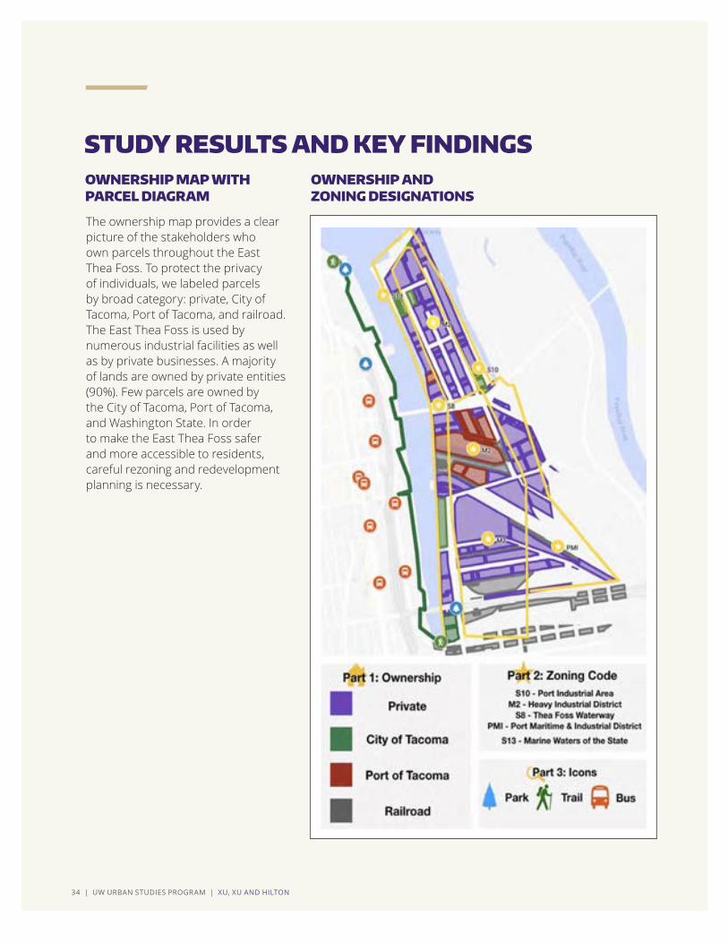
The ownership map provides a clear picture of the stakeholders who own parcels throughout the East Thea Foss. To protect the privacy of individuals, we labeled parcels by broad category: private, City of Tacoma, Port of Tacoma, and railroad. The East Thea Foss is used by numerous industrial facilities as well as by private businesses. A majority of lands are owned by private entities (90%). Few parcels are owned by the City of Tacoma, Port of Tacoma, and Washington State. In order to make the East Thea Foss safer and more accessible to residents, careful rezoning and redevelopment planning is necessary.
STUDY RESULTS AND KEY FINDINGSOWNERSHIP MAP WITH PARCEL DIAGRAM
OWNERSHIP AND ZONING DESIGNATIONS
CHAPTER 2 | LAND, WATER, AND TRANSPORTATION USES | 35
Currently there are no bus services or public access trails in the East Thea Foss. This is likely to change as a result of current planning to accommodate population growth. The City of Tacoma’s current Transportation Master Plan presents a vision to construct facilities that will support walking, biking, transit, and driving alone as viable transportation modes. This Plan refers to creating bikeways and pedestrian ways to and through the East Thea Foss.
Transportation plans for the East Thea Foss will be executed in three stages. During the first stage, parking will be accounted for, with a goal to provide the minimum amount of parking deemed necessary. No businesses are allowed to have their own parking lots because of the scarcity of lands available. The second stage will involve adding a Pierce Transit shuttle bus service to the area. Whether to also include light rail service to the area will be evaluated after other development has occurred. The final implementation stage will include adding other facilities to accommodate a variety of transportation modes.
The East Thea Foss is subject to five different zoning designations: S10, S8, S13, W2 and PMI. Zones are defined below and represented by the accompanying map.
S-10 PORT INDUSTRIAL AREA (HI)Land Uses: Marinas, launch ramps and lifts, water dependent commercial development, water dependent/related port/industrial development, water ori-ented recreational development (biking/trails), interpretive/educational/other signs, seaplane floats, major/minor/ac-cessory utilities, ecological restoration/enhancement and both non-main-tenance and maintenance dredging (ArcGIS Web Application, 2019).
M-2 - HEAVY INDUSTRIAL DISTRICT Land Uses: Heavy industrial, warehous-ing, storage, vehicle service and repair (ArcGIS Web Application, 2019).
S-8 THEA FOSS WATERWAY (DW) Land Uses: Marinas, launch ramps and lifts, non-motorized boat launch, water dependent/related/enjoyment commer-cial development, water-dependent/related port/industrial development, water-oriented recreational develop-ment, major/minor/accessory utilities, interpretive/educational/other signs, ecological restoration/enhancement and maintenance dredging (ArcGIS Web Application, 2019).
PMI - PORT MARITIME AND INDUSTRIAL DISTRICTLand Uses: Heavy industrial, warehous-ing, storage, vehicle service and repair (ArcGIS Web Application, 2019).
S-13 MARINE WATERS OF THE STATE Land Use: Marinas, launch ramps and lifts, non-motorized boat launch, water dependent/related/enjoyment commer-cial development, water-dependent/related port/industrial development, water-oriented recreational develop-ment, major/minor/accessory utilities, interpretive/educational/other signs, ecological restoration/enhance-ment and maintenance dredging (ArcGIS Web Application, 2019).
PUBLIC TRANSPORTATION SYSTEMS
LAND USE ZONING: CODE DEFINITIONS

36 | UW URBAN STUDIES PROGRAM | XU, XU AND HILTON
STUDY RESULTS AND KEY FINDINGS (CONTINUED)
Public access data shows there is one park and that there are no public trails in the East Thea Foss. The west side of the Thea Foss, on the other hand, provides linear public open space and pedestrian paths. In the future, trails could be added to the East Thea Foss to increase public access to the area.
Our team contacted the manager of the Puyallup Watershed Initiative’s Active Transportation COI, Liz Kaster, to learn more about plans related to bus services, trails, walkways, and roadways for the East
Thea Foss. She referred to the Tacoma to Puyallup Regional Trail Connection project. Currently, the Active Transportation COI along with the Washington State Department of Transportation (WSDOT), the Puyallup Tribe of Indians, other local governments, and community partners are conducting a route analysis for three potential routes. There is potential for the route to cross the East Thea Foss on its way to Tacoma’s waterfront.
PUBLIC ACCESS
PROPOSED ROUTES FOR THE TACOMA TO PUYALLUP REGIONAL TRAIL CONNECTION
In the future, trails could be added to the East Thea Foss to increase public access to the area.

CHAPTER 2 | LAND, WATER, AND TRANSPORTATION USES | 37
According to our research, approximately 90% of lands of the East Thea Foss are owned by private entities. The East Thea Foss lacks public transportation services and public access sites that would appeal to the general public. Current road conditions are not ideal for developing a modern waterfront. The East Thea Foss is used for water-oriented, water dependent, and industrial purposes. In the future, it could provide variable light industrial and commercial uses, along with parks and trails open to the public. The key is to develop a vision and plan for the East Thea Foss that promotes increasing public access and diversifying land uses, while still ensuring that elements of a working port remain in place.
CONCLUSION
The key is to develop a vision and plan for the East Thea Foss that promotes increasing public access and diversifying land uses, while still ensuring that elements of a working port remain in place.

38 | UW URBAN STUDIES PROGRAM | HNIN AND NGUYEN
CHAPTER 3 | PLACE ATTACHMENT IN RELATION TO URBAN WATERFRONTS AND PLANNING FOR INDUSTRY | 39
Place attachment is a relatively new area of interdisciplinary study in the field of environmental psychology. It combines human geography and human behavioral psychology to explain how humans develop attachment to physical spaces. Since the theory emerged in 1992, place attachment has gained recognition and significance within the realm of community planning. Researchers continue to examine the formulation of human attachment bonds, demonstrating how applications of place attachment guide toward understanding how community-focused emotions, behaviors, and cognitions impact community development. Our study of place attachment to the East Thea Foss has revolved around analyzing public comments and applying an iterative coding process to reveal three core themes. These themes revolve around what various community stakeholders know, perceive, and envision for the tideflats of Tacoma. Along with presenting these themes, we provide practical recommendations for planners and decision makers to attend to place attachment and include community members in creating spaces that are valued and meaningful to diverse community stakeholders.
By: Charis May Hnin and Jennifer Vu Nguyen
PLACE ATTACHMENT IN RELATION TO URBAN WATERFRONTS AND PLANNING FOR INDUSTRY
ABSTRACT
CHAPTER 3
FALL 2019

40 | UW URBAN STUDIES PROGRAM | HNIN AND NGUYEN
Community planners and spatial designers cannot create equitable, resilient, and inclusive communities solely focusing on the aesthetic appeal, economic gains, or ecological aspects of their plans and designs. In order to foster inclusive communities that are welcoming and meaningful to a wide array of community stakeholders, planners must consider and incorporate the concept of place attachment in their planning and design practices. Place attachment refers to emotional ties that link people to places. The concept of place attachment, which emerged in 1992 as an interdisciplinary study within the field of environmental psychology, combines elements of human geography and human behavioral psychology. Since its conception, the significance of place attachment in community planning has become increasingly recognized. As researchers continue to examine how humans
form attachment bonds to place, place attachment is viewed as a guide for understanding how community-focused emotions, behaviors, and cognitions may impact or transfer into community development. As the East Thea Foss experiences a period of transition, the gathering and analysis of various community narratives by planners and spatial designers can enable them to create inclusive, valued, meaningful shared spaces.
A VIEW OF THE MURRAY MORGAN BRIDGE, GATEWAY TO THE EAST THEA FOSS AND PORT FROM DOWNTOWN TACOMA CREDIT CHARIS HNIN
As researchers continue to examine how humans form attachment bonds to place, place attachment is viewed as a guide for understanding how community-focused emotions, behaviors, and cognitions may impact or transfer into community development.
INTRODUCTION
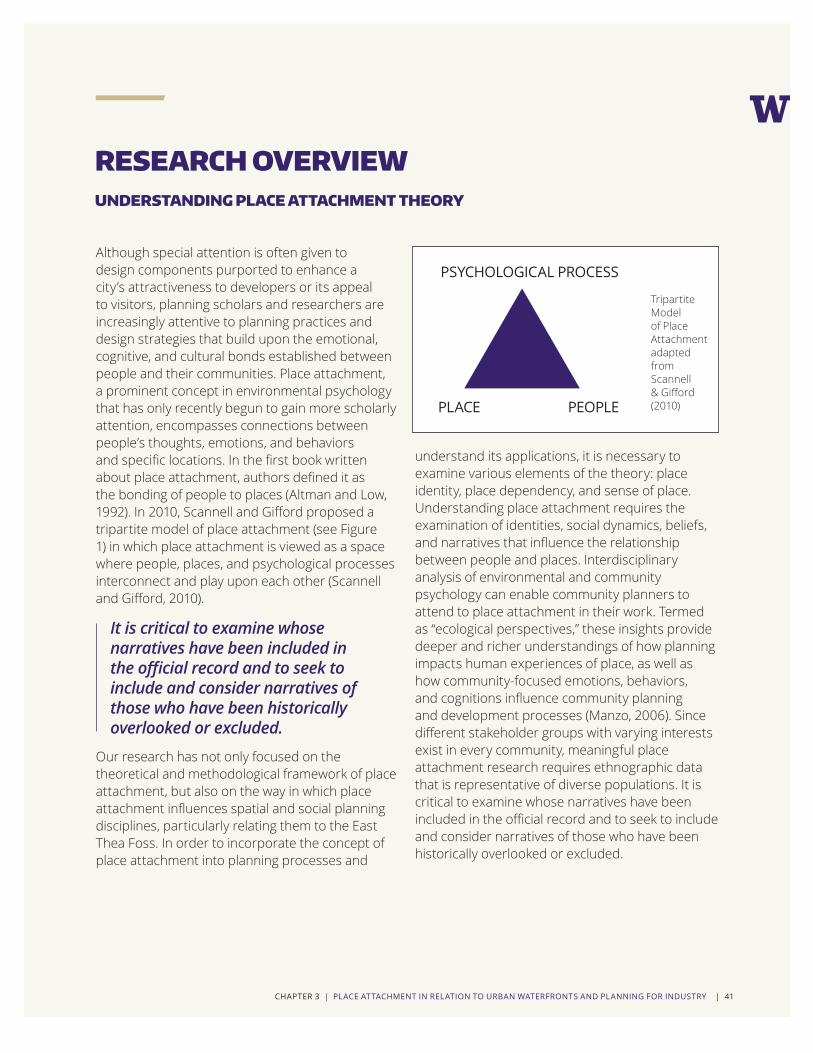
CHAPTER 3 | PLACE ATTACHMENT IN RELATION TO URBAN WATERFRONTS AND PLANNING FOR INDUSTRY | 41
Although special attention is often given to design components purported to enhance a city’s attractiveness to developers or its appeal to visitors, planning scholars and researchers are increasingly attentive to planning practices and design strategies that build upon the emotional, cognitive, and cultural bonds established between people and their communities. Place attachment, a prominent concept in environmental psychology that has only recently begun to gain more scholarly attention, encompasses connections between people’s thoughts, emotions, and behaviors and specific locations. In the first book written about place attachment, authors defined it as the bonding of people to places (Altman and Low, 1992). In 2010, Scannell and Gifford proposed a tripartite model of place attachment (see Figure 1) in which place attachment is viewed as a space where people, places, and psychological processes interconnect and play upon each other (Scannell and Gifford, 2010).
Our research has not only focused on the theoretical and methodological framework of place attachment, but also on the way in which place attachment influences spatial and social planning disciplines, particularly relating them to the East Thea Foss. In order to incorporate the concept of place attachment into planning processes and
understand its applications, it is necessary to examine various elements of the theory: place identity, place dependency, and sense of place. Understanding place attachment requires the examination of identities, social dynamics, beliefs, and narratives that influence the relationship between people and places. Interdisciplinary analysis of environmental and community psychology can enable community planners to attend to place attachment in their work. Termed as “ecological perspectives,” these insights provide deeper and richer understandings of how planning impacts human experiences of place, as well as how community-focused emotions, behaviors, and cognitions influence community planning and development processes (Manzo, 2006). Since different stakeholder groups with varying interests exist in every community, meaningful place attachment research requires ethnographic data that is representative of diverse populations. It is critical to examine whose narratives have been included in the official record and to seek to include and consider narratives of those who have been historically overlooked or excluded.
RESEARCH OVERVIEW
It is critical to examine whose narratives have been included in the official record and to seek to include and consider narratives of those who have been historically overlooked or excluded.
UNDERSTANDING PLACE ATTACHMENT THEORY
PSYCHOLOGICAL PROCESS
PLACE PEOPLE
Tripartite Model of Place Attachment adapted from Scannell & Gifford (2010)

42 | UW URBAN STUDIES PROGRAM | HNIN AND NGUYEN
In order to develop an understanding of attachment bonds experienced by diverse community stakeholders in relation to the East Thea Foss, we analyzed an archive of 287 public comments (500+ pages of content), all submitted in 2017 to the City of Tacoma regarding the Tideflats Interim Regulations. We acknowledge that these public comments do not reflect the voices and interests of all community members, particularly marginalized and historically underrepresented populations. However, the comments submitted do reflect a range of stakeholder opinions, those of longshoremen, residents, environmental activists, members of the Puyallup Tribe of Indians, small business owners, and various others.
We thematically coded the public comments to construct a grounded theory of place attachment for the East Thea Foss. The grounded theory method is a way of analyzing qualitative data; it entails collecting and processing information in such a way that the data itself reveals key themes (Charmaz, 2014). It is a nuanced and iterative process which enables one to condense large quantities of data and notice recurrent themes. First, data is sorted by broad categories called “open codes.” Further refinement of open codes yields more specific “axial codes.” Finally, axial codes are narrowed down into specific themes called “selective codes.” Figure 2 presents an illustration of our approach to analyzing data to create a grounded theory of place attachment for the East Thea Foss.
Three specific research questions guided us through the iterative coding process to reveal core themes. This aspect of the grounded theory method, forming well-developed, synoptic questions, is key to generating findings relevant to one’s particular research goals. Presented below are the three research questions around which we aligned our data analysis process:
1. What bonds people to the tideflats?
2. What emotional and cognitive attachments create these bonds?
3. What kinds of spaces and activities seem to generate attachment?
Using these research questions as guides, we manually coded public comments; this yielded 110 open codes. Then, we uploaded the public comments to a qualitative data coding software called Nvivo. Using Nvivo, excerpts from public comments that reflected aspects of place attachment were sorted into nine axial nodes. Finally, we analyzed axial codes and sorted data into three selective codes. The selective codes convey the primary themes relevant to place attachment for the East Thea Foss
CREATING A GROUNDED THEORY FOR PLACE ATTACHMENT TO THE EAST THEA FOSS
FIG.2 DATA ANALYSIS BASED ON GROUNDED THEORY
RESEARCH QUESTIONS
PHASE ONE: OPEN CODES
Phase 1 consists of condensing large quantities of qualitative data into broad, general categories. In this reserach project there were 110 open codes.
PHASE TWO: AXIAL CODES
Phase 2 consists of refining open codes into more specific categories. There were nine axial codes.
PHASE THREE: SELECTIVE CODES
Phase 3 consists of narrowing down axial codes into specific themes. This final refinement process rendered three core themes.
RESEARCH OVERVIEW (CONTINUED)

CHAPTER 3 | PLACE ATTACHMENT IN RELATION TO URBAN WATERFRONTS AND PLANNING FOR INDUSTRY | 43
The third phase of the iterative coding process, when we categorized each public comment under a core theme, revealed that one third of the public comments revolved around the direct connection between what happens in the tideflats and the City of Tacoma as a whole. It is important to note that a multitude of different feelings surfaced under this theme: anxiety, caution, anger, as well as hope. Comments reflect how people’s coexisting and contending interests differ, and at times, collide, producing an overall sense of ambivalence toward the sort of change that should occur in the tideflats. This noted ambivalence does not, however, indicate that community members do not care about the tideflats.
Many comments displayed impassioned concerns related to the potential for fossil fuel industries to expand in the tideflats. These individuals focused on the risks fossil fuel industries pose, especially how they impact air, water, soil, and human health. Most of these individuals spoke in favor of interim regulations that would stall fossil fuel-based industrial development in the tideflats while the subarea planning process played out. However, there were others who repudiated the interim regulations; these individuals cited the potential adverse impacts on existing industries. Industrial and commercial associations submitted comments to bring attention to the critical role industry plays to support key functions on local, regional, state, and national levels.
Regardless of the varying positions regarding the interim regulations and fossil fuel-based industrial development, we can trace a myriad of place attachment bonds to the tideflats: emotional, personal, professional, cultural, and socioeconomic bonds connect people to Tacoma’s tideflats.
The three selective codes which emerged from the third phase of the coding process are: 1. Community ambivalence toward change in the tideflats 2. Desire to shape and invest in the future of Tacoma and urban waterfronts 3. Conviction to preserve, protect, and steward the physical, socioeconomic, and cultural resources in and around the tideflatsIn the following passages, we offer further elaboration related to how public comments coalesced around these selective codes, which we henceforth refer to as core themes.
TOP 10 REPEATED WORDS
CORE THEME 1: COMMUNITY AMBIVALENCE TOWARD CHANGE IN THE TIDEFLATS
STUDY RESULTS AND KEY FINDINGS
In view of all of this, planners and decision makers would be wise to refrain from assuming they know the opinions and positions of their constituencies until they have practiced meaningful civic engagement, which often requires an iterative and open communication process.
WORD COUNT
Tacoma 129
Fossil 95
Future 44
People 22
Safety 22
Impact 19
Threat 19
Region 16
Health 14
Change 12

44 | UW URBAN STUDIES PROGRAM | HNIN AND NGUYEN
STUDY RESULTS AND KEY FINDINGS (CONTINUED)
A plethora of views surfaced related to the type of development that should or should not take place in and around the tideflats area. Although these views primarily reflect the positions and opinions of residents and businesses local to Tacoma, many people from the surrounding region also spoke up. To illustrate this point, we have created a map (Figure 3) which shows the number of comments from each Pierce County zip code.
Those who reside outside of Tacoma who partici-pated in political discourse related to the tideflats view the Port of Tacoma, and all the waterways of the tideflats, as a regional resource. Many felt com-pelled to voice their opinions about how manage-ment of the tideflats should occur in the present as well as in the future. For example, an individual who lives outside of Tacoma commented:
“Growing up part of a farming family in eastern Washington, my faith was also an integral part of my upbringing and caring for God’s creation is central to that faith. Creation sustains us physically, emotionally, and spiritually and we are meant to be stewards of the Earth, not to abuse or destroy it for our own selfish purposes. People of faith value responsibility, integrity, and justice for all, as well as stewardship, and we want to keep our waterways clean and neighborhoods safe for generations to come.”
CORE THEME 2: DESIRE TO SHAPE AND INVEST IN THE FUTURE OF TACOMA AND URBAN WATERFRONTS
For us as researchers, recognizing the complexity, interconnections, and diversity of these bonds, helped us answer our first research question: What bonds people to the tideflats? The table shown illustrates the top 10 repeated words from the public comments we reviewed. Our findings related to this theme remind us that the forces which inform people and compel them to support or oppose projects are complex and varied. Additionally, the way members of the public conceive of and interpret proposed changes often appear directly tied to their firsthand experience, thoughts, and feelings about the tideflats. What is known about Tacoma’s industrial legacy and the current environmental conditions of the tideflats
further inform individual perspectives. In view of all of this, planners and decision makers would be wise to refrain from assuming they know the opinions and positions of their constituencies until they have practiced meaningful civic engagement, which often requires an iterative and open communication process.
CORE THEME 1: COMMUNITY AMBIVALENCE TOWARD CHANGE IN THE TIDEFLATS (CONTINUED)
The way members of the public conceive of and interpret proposed changes often appear directly tied to their firsthand experience, thoughts, and feelings about the tideflats.

CHAPTER 3 | PLACE ATTACHMENT IN RELATION TO URBAN WATERFRONTS AND PLANNING FOR INDUSTRY | 45
Since people have multiple ways of bonding to the tideflats and to Tacoma’s urban waterfront, their hopes and desires for the future of these places also vary. The following comments from Tacoma residents reflect common desire to shape and invest in the future of Tacoma’s urban waterfront. The particularities of how each person has developed their position and opinion regarding planning for the tideflats depend upon their experiences, beliefs, and feelings as well as their memories of the place.
“...since I moved here, our reputation is slowly shifting from a dirty second class city near Seattle to a gritty and interesting City with its own Destiny. Let’s make the tideflats a selling point rather than an eyesore to be crossed between the different parts of our city. The Planning Commission has the ability to work with the Port to make that happen.”
“Polluting industry may not want additional, meaningful regulations to be put in place, but the residents of Tacoma do. Tacoma has a sorted and polluted past, but this toxic legacy doesn’t have to spell out Tacoma’s future too. Please do the right thing for our community and for the future livability of this planet.”
FIG. 3 PUBLIC COMMENTS BY ZIP CODE OVERLAID ON MAP OF PIERCE COUNTY

46 | UW URBAN STUDIES PROGRAM | HNIN AND NGUYEN
STUDY RESULTS AND KEY FINDINGS (CONTINUED)
In a musical score, multiple musical notes make up a single chord. If each public comment were a chord, then each would be comprised of multiple emotional notes. One note which resounded through many chords of our analysis is the belief that the tideflats are a public resource to be preserved, protected, and cherished. The reasons people come to share this sentiment, however, vary considerably. The way one views the purpose of the tideflats locally and regionally cannot be separated from how one has related to and experienced the tideflats in the past. Broadly speaking, the areas in and around the tideflats represent physical, socioeconomic, and cultural resources. For example, for members of the Puyallup Tribe of Indians, the Thea Foss Waterway is an essential natural resource tied to their traditional way of life. One tribal member commented,
“As you know, the safety of the tribal membership, our fishery, and our resources are of utmost importance to us and we have, and will continue to take, the necessary steps to safeguard these interests.”
This contrasts with a feeling of urgency to preserve the industries of the tideflats, which have offered economic opportunities and secure, living wage employment. A member of the public commented,
“My family and thousands like mine depend on these living wage jobs. This is nothing more than an attack on families, the middle class, and unions. Please do not regulate industries out of Tacoma.”
Although we can clearly see that the tideflats are important to people in a variety of ways, a common thread runs through these associations and reflects a shared sense of desire to preserve what individuals and groups of people perceive could be lost. We, as researchers, observed such conviction echoed across hundreds of public comments.
CORE THEME 3: CONVICTION TO PRESERVE, PROTECT, AND STEWARD THE PHYSICAL, SOCIOECONOMIC, AND CULTURAL RESOURCES IN AND AROUND THE TIDEFLATS
The way one views the purpose of the tideflats locally and regionally cannot be separated from how one has related to and experienced the tideflats in the past.

CHAPTER 3 | PLACE ATTACHMENT IN RELATION TO URBAN WATERFRONTS AND PLANNING FOR INDUSTRY | 47
ONE We recommend that all institutions involved in the Tideflats Subarea planning process coordinate their civic engagement efforts.
Inclusive engagement processes require that planners do more than solicit public comments in a project-based fashion. It requires planners to engage with the public during various phases of planning and development. During each phase, planners should analyze public perceptions and responses and share their knowledge and findings openly. In doing so, planners will gain understanding and be able to respond to what really matters to people. Such an inclusive process would also help foster coalitions and alliances toward building a more unifying, collective vision.
TWO We recommend that decision makers and planners address the frustrations and aspirations voiced by community members regarding the future of tideflats development.
This will require them to develop an understanding of how place attachments affect individuals and groups of people in social, political, and economic
ways. This calls for time and resource investment on the part of City of Tacoma and Port of Tacoma officials, as well as representatives of other jurisdictions involved in the Tideflats Subarea planning process. It is important that these formal institutions also communicate to the public that they are listening and that the public’s voices are welcome and valued.
THREE We recommend that planners and decision makers value emotional bonds as assets, and let those bonds influence them in placemaking and decision making processes.
As evidenced, hundreds of people have exchanged their thoughts and feelings about proposed changes to the tideflats area. Some members of the public went so far as to offer specific, practical recommendations in their comments. One can argue that these individuals and groups have offered up their insights and emotional currency for public use. Why not integrate these insights as part of enhancing and making more meaningful placemaking and decision making processes?
RECOMMENDATIONS
A myriad of emotional bonds exist and inform public opinions related to proposed development plans for the East Thea Foss. People spoke about their place attachments and stated their desire to take part in shaping the future of Tacoma’s tideflats and urban waterfront. How might planners and decision makers proceed to integrate peoples’ place attachments in planning for the tideflats? And, how might planners meaningfully include people in those planning efforts? We propose three tangible steps:

48 | UW URBAN STUDIES PROGRAM | HNIN AND NGUYEN
The comprehensive process of 1) researching the theory of place attachment, 2) analyzing aspects of place attachment in public comments, and 3) coding public comments to construct a grounded theory of place attachment for the East Thea Foss culminated with the development of two primary takeaways. Both relate to integrating an understanding of place attachment in community planning practices.
CONCLUSION
The first takeaway is to refrain from forming romanticized associations of place attachment. Although the concept of place attachment may generally invoke positive connotations, the development of such bonds is extremely nuanced and may incorporate elements of repulsion, apprehension, and resistance, which we observed in many comments. In order to attain a more objective understanding of place attachment, as a complex, nuanced network of associations between diverse humans and places, it is prudent to recognize that people with varying and contending values wish to participate in the development of their communities. Recalling Scannell and Gifford’s tripartite framework of place attachment, the following passages stand as suggestions for planners and decision makers grappling with the complexities inherent in people, place, and psychological process.
People: Planners should consider the multiple and intersectional identities of people who form attachment bonds to specific locations. Since human beings are social, emotional, physical, and spiritual beings who live in a complex world of competing interests, it is essential to remember that people should not be automatically and blindly categorized. For example, one should not assume that property owners would behave in a certain manner and only have certain interests; or that business owners would be proponents
of certain issues and opponents of others. Since one’s identity is tied to contending and intersecting aspects which together influence their values and behavior, one’s own values may conflict even while they coexist.
Place: Planners and decision makers should explore the locations to which people are attached and consider social, political, physical, and cultural representations of those spaces. For example, for some people, waterways are regional assets; for the Puyallup Tribe of Indians, the Thea Foss Waterway is an essential resource that constitutes their way of life; for others, the East Thea Foss represents a place of injustice, tied to the presence of the Northwest Detention Center. Planners should take heed of the fact that place associations are bound to identities and experiences, and different for different community stakeholders.
FIRST TAKEAWAY
KEY TAKEAWAYS
In order to attain a more objective understanding of place attachment, as a complex, nuanced network of associations between diverse humans and places, it is prudent to recognize that people with varying and contending values wish to participate in the development of their communities.

CHAPTER 3 | PLACE ATTACHMENT IN RELATION TO URBAN WATERFRONTS AND PLANNING FOR INDUSTRY | 49
Psychological Process: It is important to understand that place attachment entails examining the psychological process of how bonds manifest. Psychological processes related to forming attachments to place are complex, informed by people’s experiences as well as by their personal and social identities. Therefore, decision makers should take heed of how people mentally associate with certain aspects of their community. If people are expressing frustration,
it is worth exploring why they are frustrated and what their frustration may indicate. Since the City of Tacoma has a history of environmental degradation, the concept of industrial development is often associated with fossil fuel expansion. As a result, planners and decision makers should be mindful of this association and carefully state what it is they intend to develop when they refer to industrial development.
The second takeaway is to view the importance of integrating people’s emotional bonds to place within public decision making and in placemaking processes. This is important because human thoughts and beliefs are not static. They get acted upon and may change as, overtime, some of our thoughts and beliefs are subject to reinforcement, while others are not. In relation to political discourses surrounding planning and spatial design, individuals might behave in ways that support or hinder efforts. As Manzo and Perkins (2006) assert, “our thoughts, feelings, and beliefs about our local community places impact our behaviors toward such places, thus influencing whether and how we might participate in local planning efforts.”
Overall, it is important to note that place attachment does not exist in a vacuum. Place attachment is deeply rooted in local history, politics, cultures, economy, and demography. Paying careful attention to how emotional bonds shape behaviors, narratives, attitudes, and values can help leaders and decision makers establish more nuanced understandings of their community stakeholders. In making sense of a community’s behaviors, it is necessary to pay attention to all the tangible and intangible forces which influence people’s
behaviors. Doing so might better equip community planners to engage meaningfully and strategically with the people most impacted by their plans. The diverse and varying interests and backgrounds of community stakeholders must be considered. Since the most marginalized sectors of society tend often to be excluded from planning and political processes, planners and spatial designers must find ways to meet and engage with them, and incorporate their perspectives and values in meaningful ways.
Finally, it is crucial to recognize that place attachment processes are inherently dynamic and mutable as a result of people’s values and interests, and their consequent perceptions and attachments, constantly being acted upon. Place attachment is an interdisciplinary field that revolves around the connections among numerous environmental, social, and psychological factors. Changes to any of these facets may impact the development and maintenance of attachment bonds. Therefore, we suggest that community planners and decision makers heed the importance of place meaning by studying variations in levels of place attachment over extended periods of time.
SECOND TAKEAWAY

50 | UW URBAN STUDIES PROGRAM | COMAN AND MINTARAGA

CHAPTER 4 | HISTORICAL TENSIONS: MOVING FORWARD WITH PUBLIC SUPPORT | 51
The focus of this chapter is to identify historical social tensions surrounding tideflats/port area development and activities. Our primary objective has been to bring the most prominent social tensions to the fore so that port decision makers can respond to them and, in doing so, gain the support of more and different community stakeholders. Without addressing these tensions, they are likely to continue to resurface. The key findings we present emerged out of a qualitative research approach, in which we applied the grounded theory method. We sifted through more than 500 pages of public comments related to tideflats/port area development and activities. We sorted comments based on common phrasing and meaning, and applied a coding system to reveal three key tensions: seeking just transitions, finding real trade-offs, and who gets to decide?
By: Kristine Coman and Leslie Mintaraga
HISTORICAL TENSIONS: MOVING FORWARD WITH PUBLIC SUPPORT
ABSTRACT
CHAPTER 4
FALL 2019

52 | UW URBAN STUDIES PROGRAM | COMAN AND MINTARAGA
Historical social tensions – what does this refer to? Tension occurs when something is stretched, either physically or emotionally. Imagine for a moment that historical social tension resembles a rubber band: when the rubber band is loose, the historical tension causes no harm, yet it remains present; when the band is stretched, it tightens and if the tightening continues it will snap. Social tensions are the result of combined economic and social histories which have come to influence the structural circumstances we experience today. Social tensions surrounding the tideflats of Tacoma are related to place attachment and involve experiences of residents of Tacoma, members of the Puyallup Tribe of Indians, and people from other cities throughout Pierce County and the Puget Sound region.
Planning research shows that sustainable urban development involves conflict (Campbell 1996). The stories and voices that are not visible become marginalized in planning decisions (Sandercock 1998); the drive for regional smart growth and urban redevelopment creates environmental burdens, and benefits only some (Bullard 2007). These tensions surface in the public comments related to the Tideflats Interim Regulations.
Since the Port of Tacoma was created as a public port authority by Pierce County voters in 1918, tideflats development and port activities have elicited both support and resistance from
community stakeholders. The purpose of the qualitative research presented in this chapter is to identify historical social tensions and conflicts tied to Tacoma’s tideflats/port area. How are different, often competing priorities expressed? What tradeoffs provoke strong emotions? What historical changes and transitions do people recall? And, most importantly, who makes decisions for tideflats development and activities?
By revealing social tensions, we illuminate causes of social distrust, hostility, and opposition to development and business practices carried out in the tideflats today. Shedding light on discrepancies between Port of Tacoma plans and the visions of residents creates opportunities to forge new paths ahead, informed by the voices of more and different community stakeholders. Thus, this research is part of creating a bridge between those who have historically held power to make decisions and those who have been excluded from agenda setting and decision making processes.
Shedding light on discrepancies between Port of Tacoma plans and the visions of residents creates opportunities to forge new paths ahead, informed by the voices of more and different community stakeholders.
INTRODUCTION

CHAPTER 4 | HISTORICAL TENSIONS: MOVING FORWARD WITH PUBLIC SUPPORT | 53
Our research involved sifting through qualita-tive data related to the Tideflats/Port Interim Regulations. We found that primary concerns related to tideflats development center around eco-nomic, environmental, and social circumstances, as well as relationships between those with decision making authority and members of the public. Local residents, community groups, members of the Puyallup Tribe, local environmental organizations, and others who live elsewhere in Pierce County and the broader Puget Sound region have given voice to a myriad of concerns and priorities.
We began with a review of archives maintained by the Tacoma Public Library’s Northwest Room. We reviewed newspaper clippings stored in files and organized by year. We applied the grounded theory method, which “requires us to stop and ask analytic questions of the data we have gathered” (Charmaz, 2014, p.109). This method enables one to discover social patterns and structures via collection, com-parison, and sorting of qualitative data. It allowed us to identify the genuine attitudes of larger cross sections of the population and to appreciate social tensions. In this process, we applied coding to
categorize segments of our data by short name linked to broader themes. In doing so, we were able to summarize and account for each piece of data we observed.
Prior to applying the grounded theory method, we formed an overarching research question informed by our archival research: What tensions and con-flicts revolve around tideflats development and activities? We considered three sub-questions: Are different competing priorities expressed? What standoffs and tradeoffs provoke strong emotions? Which historical changes or transitions do people mention? After formulating this set of questions, we sifted through 500 pages of public comments. We selected, sorted, and highlighted comments, text, and quotes which helped us answer our research questions and we developed open codes. We com-pared and related open codes to one another to create axial codes. Ultimately, we created selective codes, or themes, which enable us to present a set of findings related to our research questions. The visual representation below shows the progression of our coding process.
RESEARCH OVERVIEW
GROUNDED THEORY PROCESS
PHASE ONE: OPEN CODES
PHASE TWO: AXIAL CODES
PHASE THREE: SELECTIVE CODES

54 | UW URBAN STUDIES PROGRAM | COMAN AND MINTARAGA
The following table presents examples of the open codes we created for the public comments we reviewed. We sorted and categorized quotes based on key repeated words. We grouped open codes with similar meaning to create axial codes. We used the software program Nvivo to automatically code words. This minimized the time required to do the work and maximized the results.
RESEARCH OVERVIEW (CONTINUED)
OPEN CODES FROM PUBLIC COMMENTS
“Tacoma has been burned before by waiting to put Changes and transitions interim regulations in place, and it could certainly happen again”
“Pausing fossil fuels now is essential not only for Balancing different goals Tacoma’s protection in the short term, but also for a high-quality subarea plan”
Past pollution, past wrongs “Recovering from 100 years of polluting the Port/Tide flats and Commencement Bay areas”
Short term versus long term “We want decent paying jobs that are good for workers and good for the environment”
Social responsibility, “Tacoma is at a crossroads, and we need to ask some contested definitions difficult and important questions about our collective future”
Priorities and goals “Tacoma citizens and I want a cleaner and sustainable future where the inherent value of the environment is recognized protected and leveraged”
Strong emotions “Tacoma cannot wait to take action”
Discouraging future “Interim regulations need to pause proposals before any pollution production new ones can be made and grandfathered in”
GROUNDED THEORY CODING - PUBLIC COMMENTS OPEN CODES

CHAPTER 4 | HISTORICAL TENSIONS: MOVING FORWARD WITH PUBLIC SUPPORT | 55
TRANSFORMATION OF OPEN CODES INTO SELECTIVE CODES
• Short term versus long term goals • Current and ongoing vulnerability of the Tideflats • Concern over lack of jobs • Renewable energy versus fossil fuel • New vision for Tacoma versus old past
• Concern with health and safety • Presence of environmental injustice, need for environmental justice • Presence of past pollutions versus what is next • Need for a new clean industry for Tacoma • Contested legitimacy of regulations, accountability
• First People’s right to be at the planning table • What does it mean to be socially responsible • Need for community involved planning • Need for improved communication strategy • Anger, protest about fossil fuel
short term vs. long term
environmental injustice
social responsibility, contested definition
OPEN CODES AXIAL CODE

56 | UW URBAN STUDIES PROGRAM | COMAN AND MINTARAGA
STUDY RESULTS AND KEY FINDINGSThe final, selective codes indicate our key findings. Reading through 500+ pages of public comments three times assisted us in obtaining a clear sense of public concerns, opinions, ideas, and solutions. Our qualitative research analysis produced three key findings, or selective codes (themes):
1) Seeking just transitions
2) Facing real trade-offs
3) Who gets to decide?
The table below presents evidence from our qualitative analysis for each key finding.
THREE KEY THEMES REVEAL SOCIAL TENSIONS
• Lack of jobs
• Short term vs. long term
• Presence of past pollution vs. what’s next
• Environmental injustice
• Health and safety
• Legitimacy of regulations and accountability
• Social responsibility, contested definition
• Anger about fossil fuels
• Inclusive planning
SEEKING JUST TRANSITIONS
FACING REAL TRADE-OFFS
WHO GETS TO DECIDE?
This theme answers our first research question: How are different competing priorities expressed? About 40% of the comments spoke to the need to create a new vision for the Port of Tacoma, one that involves transitioning away from fossil fuel-based industries and toward renewable industries. Many asked decision makers to focus on long term gains over short term profits. Some pointed out that “jobs in the renewable energy fields are already outpacing jobs in fossil fuel industries.” Others expressed the need to prioritize maintaining living wage jobs, still tied to
industry: “…jobs that are decent paying and good for workers and the environment.”
Those who recall the “aroma of Tacoma,” and who participate in ongoing efforts to cleanup and restore the tideflats connect dirty industries of the port with their perceptions of the port. These people are ready for a new reality and know it depends on port practices changing. Many people expressed the need to create “environmentally sustainable industries that produce large numbers of middle class jobs.”
SEEKING JUST TRANSITIONS

CHAPTER 4 | HISTORICAL TENSIONS: MOVING FORWARD WITH PUBLIC SUPPORT | 57
This theme answers our second research question: What standoffs and tradeoffs provoke strong emotions? This theme revolves around deep-seated, emotionally-charged comments related to the effects of pollution on current public health and safety. These comments underscore questions about environmental justice and the need for greater accountability. Historically, pollution produced by port industries have burdened people who live in proximity of the port. Many of these residents beg officials to “value clean air and water over money.” Many stated that they “can still taste that pervasive and disgusting aroma of Tacoma,” and that they are “thankful for the actions finally taken by good folks like you to remedy the problem.”
When we choose to do one thing, it often means that we cannot do another thing; this gets at the need to find trade-offs. If we regulate pollution, we limit industrial practices. If we support any/all industrial development, we fail to protect the health and safety of community members. Some people must give a little, so that more people benefit. This theme captured about 31% of all comments, with many people urging officials to adopt regulations “to protect the health of Tacoma’s residents and environment.” The consensus among these community members is that “our environment must not harm us.”
This answers our third and final research question: What historical changes and transitions do people mention? This question invites us to consider related questions. Do social groups affected by port industries have a say in determining which activities take shape in the tideflats? Are those who been historically excluded from the planning table offered time and space to speak up? These questions guided us in considering why research on historical social tensions is paramount for future port planning and development. Considering the voices that have been excluded in the past can help us form an inclusive vision for the port.
Many people asked for communications to be disseminated in different languages and for a larger notification area related to port projects. People voiced the need to confer with the Puyallup Tribe of Indians regarding land use planning, referring to the Puyallup Tribal Council’s respect for natural habitat: “You are the key to protecting our environment and limiting human destruction of our planet.” As people gave voice to their anger about polluting industries, they insisted that their voices be heard and asked to be able to participate in
port planning processes. In particular, people who live nearby the port made comments like, “[I] look forward to working with you on this matter.”
Almost one third (29%) of the 500+ pages of comments related to this third theme. Of that portion, 45% directly stated the need for Port and City officials to practice social responsibility, which entails making the right decisions for the people and for the future of Tacoma. People emphasized the importance of restoring and preserving a healthy environment for future generations, with clean air, water, and soil; and creating jobs that will not make us sick. This comment sums up attitudes which combine within this third theme, “we must collectively SHIFT… we really need City officials to become the voice of the changes that must occur.”
FACING REAL TRADE-OFFS
WHO GETS TO DECIDE?
People emphasized the importance of restoring and preserving a healthy environment for future generations, with clean air, water, and soil; and creating jobs that will not make us sick.

58 | UW URBAN STUDIES PROGRAM | COMAN AND MINTARAGA
Whose are the voices that have been historically excluded? Thomas Sugrue’s award winning urban history of Detroit, Origins of the Urban Crisis, examined patterns of racial segregation that kept people of color from making economic gains for themselves. Black Americans were systematically locked out of decision making affairs and made to suffer as a result of institutionalized racism.
The 1929 Residential Security Map of Tacoma (Map 1) shows redlined areas, designated in the map as fourth
grade (D). Banks and grocery stores pulled out of these redlined neighborhoods, causing a cascading effect of disinvestment which resulted in severe economic downturn for the families living in those neighborhoods. The red areas in the Tacoma Equity Map (Map 2) reflect neighborhoods of higher opportunity today. You can clearly see the lasting impression of redlining practices from 1929 in the map from our time.
WHOSE VOICES HAVE BEEN HISTORICALLY EXCLUDED?
STUDY RESULTS AND KEY FINDINGS (CONTINUED)
1929 TACOMA RESIDENTIAL SECURITY

CHAPTER 4 | HISTORICAL TENSIONS: MOVING FORWARD WITH PUBLIC SUPPORT | 59
2019 TACOMA EQUITY MAP

60 | UW URBAN STUDIES PROGRAM | COMAN AND MINTARAGA
The following table illustrates how our coding process culminated with the three themes discussed previously. The table lists the three key themes (selective codes) and provides a sample of public comments which refer to each.
RESEARCH OVERVIEW
Lack of jobs“If our only vision is for jobs that give work to a few, profits to fewer, and harms the health of many then we must find a new vision.”
Short term vs. long term“Tacoma is at a crossroads, and we need to ask some difficult and important questions about our collective future.”
Presence of past pollution vs. what’s next
“We could be the city of Destiny by creating clean energy jobs and caring for our environment.”
Environmental injustice“As a resident of Tacoma, I do NOT want more pollution, more danger, more environmental destruction here, nor upstream nor downstream.”
Health and safety“…not convinced that the economic benefits outweigh the negative effects of the petroleum industry.”
Legitimacy of regulations and accountability
“The last 17 years I have earned a living in the tideflats…the mills and factories have made drastic improvements in environmental responsibility.”
Social responsibility, contested definition
“Industry of Tacoma must focus on renewable energy and social and environmental responsibility.”
Anger about fossil fuels“Area residents in 2016 stopped the ‘World’s Largest Methanol Plant’ from being built.”
Inclusive planning“Develop a broad community consensus about its (the Tideflats) future…”
“Work with and encourage the Puyallup Tribe to be at the table and to be a part of the decision making”
SEEKING JUST TRANSITIONS
FACING REAL TRADE-OFFS
WHO GETS TO DECIDE?

CHAPTER 4 | HISTORICAL TENSIONS: MOVING FORWARD WITH PUBLIC SUPPORT | 61
Leonie Sandercock advises that “if we want to work toward a policy of inclusion, then we better have a good understanding of the exclusionary effects of planning’s past practices and ideologies” (1998, p. 30). If we want our planning practices to be inclusionary, then we must include a myriad of perspectives (those of women, indigenous peoples, people of color, low-income people). This allows for a process that makes space for more possibilities, leaves fewer people out, and redefines planning as an activity informed by many human perspectives and interests.
Partnerships among the Port of Tacoma and other local stakeholders, like the City of Tacoma, the Puyallup Tribe of Indians, the City of Fife, Pierce County, and various environmentalist groups, are working together to restore Tacoma’s tideflats. This shows a change in focus among Port officials and their desire to work with community members toward common goals. The City of Tacoma’s decision to formalize a Tideflats Subarea Plan demonstrates additional government efforts to work more closely with community members to plan for the future of Tacoma’s tideflats.
The public comments we reviewed make it obvious that just transitions are needed now. These just transitions must address real trade-offs and everyone should be part of making decisions. Just transitions will ensure that both the opportunities
and burdens of production are shared more evenly across Tacoma, and that new industrial opportunities are embraced by a city that is prepared for the future. Addressing real trade-offs puts social responsibility at the forefront of decision making processes. It also casts a bright light on environmental justice issues and requires planners and other decision makers to address those issues. By capturing more voices in the planning process, we can ensure that a few do not control the fate of many.
In conclusion, we advise that if historical tensions are not resolved, they will continue resurfacing and fracturing local communities. We encourage port stakeholders to embrace opportunities to research and reflect on public comments related to port/tideflats development and land uses. We suggest that by improving communication strategies, by offering a multitude of access points for decision makers to receive input from community members, and by providing access to opportunities to participate in planning processes, the tideflats/port of Tacoma can be transformed into a space that represents the needs and visions of local people.
CONCLUSIONBy capturing more voices in the planning process, we can ensure that a few do not control the fate of many.

62 | UW URBAN STUDIES PROGRAM | TORREZ AND BUSHNELL

CHAPTER 5 | PUBLIC ACCESS AND INDUSTRIAL SHORELINES | 63
Public access is a vital part of any city. Industrial areas are often considered incompatible with public access due to a range of public health concerns (e.g., exposure to water and air pollution) and safety issues (e.g., incompatibility of pedestrian uses and long-haul trucks and heavy machinery). However, industrial areas can be blended with public access points that add recreational and social outlets for people while also improving a city’s aesthetic quality and adding to its character. Not only is public access a way to provide more opportunities for residents, tourists, and community members to experience different angles of a city, but it also increases human connection to place and awareness of local industry, and can positively impact the local economy. To consider how the Port of Tacoma could create new public access points in the East Thea Foss, we conducted case studies on other ports that have successfully integrated public access projects along industrial waterfronts. Through our investigation, themes emerged; and from these themes, we created a set of best practices which can be implemented in the East Thea Foss.
By: Alyssa Torrez and Riley Bushnell
PUBLIC ACCESS AND INDUSTRIAL SHORELINES
ABSTRACT
CHAPTER 5
FALL 2019

64 | UW URBAN STUDIES PROGRAM | TORREZ AND BUSHNELL
The purpose of this research is to present a case in favor of increasing public access in the local tideflats/port area. Specifically, our purpose is to promote adding public access in the East Thea Foss, a portion of the tideflats/port area planned to feature light industrial and commercial land uses. Our research showcases public access projects which have been successfully implemented on other waterfronts in industrial areas. From the case studies we compiled, we have extracted key themes and offered a set of best practices for increasing public access in the East Thea Foss.
Public access to urban waterways is supported by the public trust doctrine (Sax, 1970). This is an approach that treats natural resources such as water as shared assets. In Washington State,
the Shoreline Management Act (1971) establishes public access to the shoreline as an important aspect of the public trust, along with water-based economic uses, and environmental protection. This policy is enacted through local Shoreline Master Programs, many of which are still working to integrate increased environmental protection and improved public access with established economic uses. Tacoma’s updated Shoreline Master Program was passed in 2013 (City of Tacoma, 2013), and the City is still working to implement the improved standards. As a maritime, industrial city, Tacoma is in a unique position to show leadership on this challenge.
INTRODUCTION
We identified cities across the United States, as well as one international site, which have succeeded in implementing public access projects along industrial waterfronts similar to the East Thea Foss. The six sites reflect a diversity of geographic locations, waterfront types (e.g., river, coastal, inland), and public access development (e.g., arts/culture, parks, boardwalks). We looked for sites and projects that were relatable to the East Thea Foss, whether by history, demographics, or industries present. This helped us trace direct
connections to the local waterfront and working port. Ultimately, these connections helped us imagine how public access can be implemented in the East Thea Foss.
RESEARCH OVERVIEWTracing direct connections from case studies to the local waterfront and port helped us imagine how public access can be implemented in the East Thea Foss.

CHAPTER 5 | PUBLIC ACCESS AND INDUSTRIAL SHORELINES | 65
The six sites reflected by the following case studies demonstrate possibilities for expanding public access opportunities in the East Thea Foss. For each, we provide historical context, a description of the project, an explanation of funding sources, and a reflection on the social and economic impacts experienced locally and regionally. We capture public response to each project, pulling from reviews left on Trip Advisor and Yelp. These reviews underscore what public access in industrial
areas can mean to people; and offer insights related to place attachment, demonstrating how by enabling access to industrial waterfronts, people may develop meaningful attachments to the places where they live. Finally, for each case, we have drawn connections to the East Thea Foss. By observing cultural, geographic, economic, and other similarities, local decision makers and planners can feel inspired and empowered to expand public access along the East Thea Foss.
OVERVIEW
The Port of Oakland expanded and reopened Port View Park in 1995. This followed extensive redesign and reconstruction necessitated by the Loma Prieta earthquake of 1989. The park encompasses 4.5 acres of public space, with areas for fishing, strolling, picnicking, and planning special events. The park offers spectacular views of San Francisco Bay, the San Francisco skyline, and Port of Oakland maritime operations at the Seventh Street Terminal. Port View Park is also home to the International Maritime Center, a non-denominational chapel and recreational facility for visiting seafarers.
Middle Harbor Shoreline Park is a 38-acre shoreline park, created and maintained by the Port of Oakland. The park offers more than two miles of pathways, which encircle Middle Harbor Basin; and access to the shoreline, where one can appreciate views of the bay, natural features, and maritime activity. Planning and designing this park revolved around community input, with community members identifying key goals for the park.
IMPACT
Middle Harbor Shoreline Park draws members of the public to the waterfront for events throughout the year, including the Treasure Island Music Festival in October and the Second Sky Music Festival in June.
APPLICATION TO EAST THEA FOSS
Port View Park and Middle Harbor Shoreline Park are surrounded completely by either port development or water, illustrating that public access can be provided in the thick of industrial land uses. The City of Oakland’s website describes the parks as places where the public can view industry up close, while also enjoying their piece of the waterfront. Parks and other public access features in the East Thea Foss could be similarly described.
FUNDING
Middle Harbor Shoreline Park was developed by the Port of Oakland as an innovative bi-product of the federally-funded Oakland Harbor Navigation Improvement Project, which deepened estuary ship channels. Port View Park was also developed by the Port of Oakland. Both parks are maintained by the Port of Oakland.
CASE STUDIES
Planning and designing this park revolved around community input, with community members identifying key goals for the park.
1. PORT VIEW PARK AND MIDDLE HARBOR SHORELINE PARK • OAKLAND, CALIFORNIA

66 | UW URBAN STUDIES PROGRAM | TORREZ AND BUSHNELL
PUBLIC RESPONSE
Anonymous quotes pulled from Trip Advisor:
“We walked as far as we could....all the way to the end of the path. The view of the city is stunning. This area is right in the middle of the Oakland port. We loved watching the enormous ships, the unloading of the containers, and the bustle of trucks heading to I-80 with a load of containers to somewhere in America. The park is off the beaten path and very restful. Plus, it’s fun traveling across the Bay Bridge.
If you have a car and are staying in San Francisco 99, consider the adventure. It’s much better than Fisherman’s Wharf.”
“Tucked away on the waterfront within the very busy Port of Oakland, this is a great place to observe the workings of a major port facility. Lots of ships, tugs, etc. going about their business. Beautiful views of San Francisco, the Bay Bridge, and the SF Bay south of the Bay Bridge. Excellent place for photography.”
CASE STUDIES (CONTINUED)
1. PORT VIEW PARK AND MIDDLE HARBOR SHORELINE PARK • OAKLAND, CALIFORNIA
2. CRUISE SHIP PROMENADE • LOS ANGELES, CALIFORNIA
OVERVIEW
Completed in 2004, the Los Angeles Cruise Ship Promenade is the first dedicated public open space and boardwalk at the Port of Los Angeles. The Promenade encompasses four acres of prime waterfront property situated between the Vincent Thomas Bridge and the World Cruise Center in San Pedro, at the intersection of Swinford Street and Harbor Boulevard. The Promenade is easily accessed from the Harbor Boulevard off-ramp from I-110 and from CA-47. The entire Cruise Ship Promenade is filled with dynamic public art which incorporates furniture, tile work, banners, wind-activated sculpture, kiosks, and signs.
IMPACT
Many lower-income residents of San Pedro did not always enjoy access to the waterfront because of Port of Los Angeles shipping activity; this Promenade was part of an ongoing waterfront reclamation effort to change that. This project aimed to address social and economic sustainability by providing a catalyst for new investment and revitalization, and by connecting communities around a shared project. As a result of this project, the Port of Los Angeles drew 498,000 cruise ship passengers in 2017, from 109 cruise ships.
APPLICATION TO EAST THEA FOSS
The Cruise Ship Promenade, although designed around incoming and outgoing cruise ship tourists, is an important community fixture, one which links an urban commercial area directly to the Port of Los Angeles. Similar to the views one can appreciate from Port View Park in Oakland, of cranes moving in, one can see the cruise ships come and go from the promenade. One also views industry in action, as would be the case from public access points throughout the East Thea Foss. Similar to the East Thea Foss’ proximity to both commercial areas in Downtown Tacoma and the Dome District and industrial areas of the Port of Tacoma, the Cruise Ship Promenade is located near commercial and industrial uses. This combination can drive economic development.
The Cruise Ship Promenade aimed to address social and economic sustainability by providing a catalyst for new investment and revitalization, and by connecting communities around a shared project.

CHAPTER 5 | PUBLIC ACCESS AND INDUSTRIAL SHORELINES | 67
3. ELBPHILARMONIE HAMBURG • HAMBURG, GERMANY
OVERVIEW
The Port of Hamburg is Germany’s largest port. Named the country’s “Gateway to the World,” it is ideally situated for warehousing and transshipment facilities. The Elbphilharmonie is built upon a historically significant site, where the largest warehouse of the Port of Hamburg once towered over the city’s waterfront in front of the Speicherstadat UNESCO World Heritage site. The site now features two concert halls, a hotel, apartments and a public plaza which extends around the whole building. This plaza also serves as a connection between the old harbor and the modern building above it. The plaza is open to all members of the public, not just to hotel guests and concert-goers. All visitors are welcome to enjoy the view and connect with and learn about the impressive architecture.
APPLICATION TO EAST THEA FOSS
Tacoma has a strong arts and culture community. Public access to the East Thea Foss could build upon these assets and help connect the east side to the west side of the waterway, where the Museum of Glass is, as well as to the rest of Downtown Tacoma, where the Tacoma Art Museum, the Washington State History Museum,
FUNDING
The Port of Los Angeles allocated $14 million to develop the Cruise Ship Promenade.
PUBLIC RESPONSE
Anonymous quotes pulled from Trip Advisor:
“Our cruise ship stopped in San Pedro and we had some time to spend here in the afternoon. Besides the cruise port there are several attractions in the area - the USS Iowa, the Maritime Museum and a ferry service over to Catalina Island. The area is
and the University of Washington Tacoma campus are. The addition of a plaza, like the one around Elbphilharmonie, can ensure that everyone, not just patrons, can access the area.
FUNDING
This project cost €77 million to develop. The City of Hamburg funded the project using money collected from taxpayers.
IMPACT
With up to 17,000 visitors daily, guests flock to the Elbphilharmonie. The site is situated in the midst of many of Europe’s most popular attractions and is frequented not only by locals but by tourists.
PUBLIC RESPONSE
Anonymous quotes pulled from TripAdvisor:
“Family of four were pleasantly surprised at how much fun it was to take the escalator up and walk all around this new amazing and glorious piece of architecture.”
“It was really worth it as we got to see the harbor and the city by going around the 360 degrees balcony.”
nicely developed with good walking paths lined with some trees and benches. Restaurants are just up the street on 6th and 7th streets.”
“Public mooring has finally arrived in San Pedro. It has always irritated me that there was only one to three spots, on the entire waterfront, to park a boat for a few hours. All of those restaurants with no access by boat. Now there is a brand new ‘courtesy dock’ where you and I can park a boat, grab a bite, and not have to rush back. Four hours is the time limit per day. More people should take advantage of this courtesy convenience.”

68 | UW URBAN STUDIES PROGRAM | TORREZ AND BUSHNELL
CASE STUDIES (CONTINUED)
4. SACAJAWEA STATE PARK • PASCO, WASHINGTON
5. PEPPER PARK • NATIONAL CITY, CALIFORNIA
OVERVIEW
This “267-acre day use park is located at the confluence of the Snake and Columbia Rivers” in Washington State (Washington State Parks, n.d.). The park offers 1.2 miles of hiking trails, moorage, 200 feet of dock space, fishing, swimming, and interpretive activities, including representations of Native American dwellings and the Sacajawea Interpretive Center. This property was deeded to Washington State Parks in 1931 and named after Sacajawea, a Shoshone Indian woman who travelled with Lewis and Clark, helping them as an interpreter and “emissary of peace between them and Native American tribes” (Washington State Parks, n.d.).
APPLICATION TO EAST THEA FOSS
This case underscores the importance of recognizing and understanding the historical context of a site. Local history is integrated into many projects throughout the Puget Sound region and could be represented in public spaces in the East Thea Foss. There is opportunity to work with local tribes to create historic representations that capture their legacy in the region and relationship to the local waterways.
OVERVIEW
“Named after prominent National City businessman and civic leader Leonard Pepper, this 5-½ acre park adjoins to the Sweetwater Channel and offers colorful play equipment, a convenient boat launching ramp and a well-equipped fishing pier with lighting for night fishing in the vibrant San Diego Bay” (Port of San Diego, n.d.). Tankers arrive on the scene to offload lumber from the Pacific Northwest and cars from Japan.
FUNDING
A taxpayer general fund originally paid for this park’s development and maintenance. In 2012, funding shifted to Discover Pass user fees.
IMPACT
A study initiated by the Washington State Parks and Recreation Commission has confirmed that state parks remain a significant economic driver in Washington State, with a total estimated contribution of $1.4 billion a year.
PUBLIC RESPONSE
Anonymous quote pulled from Trip Advisor:
“The road into the park goes through an ugly industrial area, but if you persist you will find a green treed oasis at the confluence of the Snake and Columbia Rivers. Big sycamore trees shade paths with signage about local history.”
APPLICATION TO EAST THEA FOSS
This park is enveloped by industrial land just like Port View Park in Oakland. It offers views of industrial shipping and includes a boat ramp open to the public. The East Thea Foss could provide similar accommodations for public use.
FUNDING
The park’s expansion is funded with $54,000 from the Environmental Health Coalition.
There is opportunity to work with local tribes to create historic representations that capture their legacy in the region and relationship to the local waterways.

CHAPTER 5 | PUBLIC ACCESS AND INDUSTRIAL SHORELINES | 69
6. BOSTON HARBORWALK • BOSTON, MASSACHUSETTS
OVERVIEW
Started in 1984, the Boston Harborwalk project provides an almost continuous, 43-mile long shoreline walkway open to the public. The Harborwalk connects neighborhoods directly to the waterfront and many harbors, extending into maritime industrial areas and offering glimpses of industrial operations. The Harborwalk also offers parks, beaches, museums, public art installations, historical exhibitions, and restaurants. Developed through a joint effort of the City of Boston, the Boston Planning and Development Agency, the Massachusetts Department of Environmental Protection, the Boston Harbor Association, and private property developers, this project falls under the Public Waterfront Act (Chapter 91), which requires new waterfront development to be set back from the shoreline.
APPLICATION TO EAST THEA FOSS
The Harborwalk’s design concept is similar to our local Prairie Line Trail. By extending a local trail route to the East Thea Foss, people can feel more connected to their waterfront. Accessible walkways can offer visitors opportunities to view downtown Tacoma from the east, as well as maritime and industrial activities taking place throughout the port.
FUNDING
Specific funding information was unavailable. Likely, a combination of federal, local, nonprofit, and private funds combined in the development of the Harborwalk.
IMPACT
The Harborwalk has brought a range of decision makers from public and private agencies together around a joint effort to provide a continuous public access corridor.
PUBLIC RESPONSE
Anonymous quote pulled from Trip Advisor:
“First and foremost, Harborwalk is designed to guarantee public access to the unique environment along the Boston Harbor, while encouraging balanced growth along the entire waterfront.” - Mayor Raymond Flynn, 1984
“Boston has done an excellent job of providing a wonderful place for everyone to enjoy seeing the beautiful Boston waterfront from all angles while walking on the Harborwalk. The walk is easy to navigate, offers amazing views of the Boston Harbor and the surrounding buildings.”
IMPACT
Pepper Park is a host to multiple community events, like the Bayside Brew and Spirits Festival in September.
PUBLIC RESPONSE
Anonymous quote pulled from Yelp:
“This park is great! Great play area for kids, standard park bathrooms, and a fishing area. We go here once a week. Even had our daughters 2nd birthday party here last minute on a Saturday. There’s always parking. You have to drive past the
area where all the cars that get shipped to San Diego are, but it’s fine. Also, if you are a cyclist this is a great place to park to catch the South Bay bicycle trail.”
“I usually go here for a quick walk along the bay. Sometimes I will bring my fishing pole to fish. A very relaxing place. They have a boat launch here if you want to take your boat out. They also have a fishing pier here. A small park area if you plan on having a picnic or something. A small playground for young kids. The area is also kept clean by the city of National City. The restrooms here are also kept very clean.”

70 | UW URBAN STUDIES PROGRAM | TORREZ AND BUSHNELL
STUDY RESULTS AND KEY FINDINGSTaken together, case studies revealed a set of themes that are helpful to bear in mind while considering possible implementation of public access throughout the East Thea Foss.
VIEW OF URBAN/PORT INDUSTRYFrom reviews posted on Trip Advisor and Yelp, we noticed that many people specifically referred to how much they enjoy viewing maritime and industrial port activities from public spaces.
ECONOMIC BENEFITSPublic spaces often go hand in hand with economic development. This is already observed in Tacoma, along Ruston Way’s waterfront. There, a path enables people to walk from Old Town to Point Ruston; along the way, businesses flourish. Similarly, the East Thea Foss could be adjoined by a continuous public access corridor to the esplanade on the west side of the waterway. This would attract more people to businesses along the waterfront and in the Dome District. Another way that public space can drive economy is by hosting events and festivals, like those of Middle Harbor Shoreline Park and Pepper Park.
RECREATIONOne of the most obvious themes reflected by the six cases is access to recreational activities. All of the sites offer access to beachcombing, fishing, kayaking, boating, rowing, or some other water-based recreation. The cases demonstrate that people are happy to go to spaces near industrial activity and recreate.
CARDINAL DESTINATIONSIconic destinations can define an area. This is evidenced by Middle Harbor Shoreline Park, which people frequent as a result of its location. This
reveals how much industrial lands of ports can mean to members of the public.
CONNECTIVITYMany of the case studies were connected to downtown and commercial areas through continuous public access corridors. Such corridors could improve the local “imageability” of the Port of Tacoma, as they would enable people to experience the port as connected to the rest of the city. The East Thea Foss would play a pivotal role in connecting the port to the rest of the city since it lies directly between the two.
PUBLIC SUPPORTThe case studies reveal that industrial ports can be embraced by local communities. The possibility of expanding public access to and through the East Thea Foss links to the possibility of increasing awareness of port operations and of the Port of Tacoma as a public authority. Community stakeholders who were not previously exposed to all the positives the Port brings to the community will gain exposure and develop a vested interest in port activities.
PRESERVATION OF INDUSTRIAL LANDPublic access projects can protect industrial lands from turning over to different development interests. As people gain access to their port and become personally attached to port industries, they are more likely to support the port as a vital fixture.
The possibility of expanding public access to and through the East Thea Foss links to the possibility of increasing awareness of port operations and of the Port of Tacoma as a public authority.

CHAPTER 5 | PUBLIC ACCESS AND INDUSTRIAL SHORELINES | 71
Our case studies reveal that providing public access can help working ports garner public support. From the themes we extracted, we formed three best practices which we offer as a way forward for decision makers and planners to increase public access in the East Thea Foss: community engagement, port commitment, and joint efforts.
COMMUNITY ENGAGEMENTEach project relied on community engagement and reflected community desires. This ensures that the public access efforts align with the desires and interests of local residents and community members. Community engagement efforts can take the form of a community design fair, like the one the Port of Oakland hosted, which attracted 1,500 community members who helped determine which recreational facilities should be included along their waterfront.
PORT COMMITMENTThe research demonstrated strong commitment from Port agencies to their public constituencies. If the Port of Tacoma can demonstrate similar commitment to working with community stakeholders to expand public access in the East Thea Foss, the Port will garner support from residents, businesses, the City of Tacoma, and other local government agencies. The Port’s commitment to the community is essential for creating public spaces that are safe and welcoming to members of the public.
JOINT EFFORTSCase studies revealed that joint efforts and the forming of coalitions among various agencies is required to create public spaces in port areas and along urban waterfronts. Economic development boards, environmental agencies, businesses, and citizens come together to make these projects happen. In doing so, tensions related to port uses and public access can be addressed by diverse stakeholders and a shared vision can be created.
CONCLUSION

72 | UW URBAN STUDIES PROGRAM | CALE, RANDHAWA AND SORENSON

CHAPTER 6 | ECONOMIC DEVELOPMENT | 73
This chapter focuses on economic development in relation to the East Thea Foss in Tacoma, Washington. Early on in our research, we noted tensions between industries in the tideflats area and various groups in Tacoma. We wanted to investigate the role of industry historically, especially its importance as an economic driver, while also recognizing the ways in which industry has degraded the environment and encouraged stratification of social classes. From looking back at the myriad effects of industry, our goal has been to look ahead to ways we can safeguard industry while also taking a stand for a healthy environment and for the people who have historically not benefitted from industrial activities associated with the tideflats. We investigated why and how industry can be protected in urban areas. This led to our discovering how industry has changed over time and how implementation of Industry 4.0 could usher in sustainable and socially just ventures for the local port. Finally, we focused on the most compelling elements of Industry 4.0 and measures to move local industry forward.
By: Anastasia Cale, Neelim Randhawa, and Andrew Sorenson
ECONOMIC DEVELOPMENT
ABSTRACT
CHAPTER 6
FALL 2019

74 | UW URBAN STUDIES PROGRAM | CALE, RANDHAWA AND SORENSON
Cities have been moving away from manufacturing and industrial jobs for some time. Leigh and Hoelzel (2012) point out that planners who champion the principles of smart growth (i.e., diverse, mixed-use, connected, eco-friendly design of space), overlook the role of industry. This observation prompted them to conclude that “industrial land is at risk in cities” (p. 87). Why? The legacy of industry is tied to “dirty jobs, unsafe work environments, and inevitable layoffs and shutdowns” (Giloth, 2012, p. 9). Along with this unsavory reputation, past industrial uses have damaged our ecosystem and severely polluted our air and waterways. However, as industry changes, the dialogue about its social and environmental effects should too. Overall, the benefits of industry should not be overlooked, and the preservation of industrial lands should be viewed as an important calling for our communities.
Manufacturing and industrial land is valuable for many reasons. For instance, industry brings living wage jobs to communities, with STEM positions accounting for 30% of manufacturing employment opportunities, and with half of those opportunities not requiring a four-year degree. Industrial and manufacturing workers are also more likely to be protected by a union (Leigh and Hoelzel, 2015; Clark and Clavel, 2012). When manufacturing sites are located in mixed-use areas, community resilience increases, with industry blocking gentrification processes and with local businesses and manufacturers helping to create self-sufficiency and vitality (Clark and Clavel, 2012).
In reading the book America’s Waterfront Revival (Brown, 2009), we learned that many ports around our country have transitioned away from maritime cargo and industrial uses to maintain themselves economically and politically viable. They have done so in the face of tremendous technological
and geopolitical change. Ultimately, relatively few working ports of the past remain competitive as maritime cargo, industrial ports. And, as communities take greater interest in port activities, Ports must turn to work with local constituencies to revision themselves. In many cases, modern ports say goodbye to their maritime cargo and industrial pasts to become lifestyle ports or even tourist hubs – harboring cruise ships, commercial strips, and sports arenas. While this is the case for the ports described by Brown in his book, it is not the case for the Port of Tacoma.
The Port of Tacoma remains intact as a maritime cargo and industrial port with international significance. Locally, the Port of Tacoma provides 1,500 jobs, with an average salary of $76,200 a year. Its activities generate about $15 million in state and local taxes. There is also burgeoning opportunity for economic development throughout the East Thea Foss, particularly for light industrial and manufacturing enterprises. At the same time, manufacturing jobs are becoming increasingly
technical with the onset of Industry 4.0, which aims to “[overcome] contemporary challenges, such as intensifying global competition, volatile markets and demands, required customization, as well as decreasing innovation and product life cycles” (Müller, Keil, Voigt, 2018, p. 1); and, the industrial and
INTRODUCTIONTo ensure that the Port of Tacoma, and specifically that the East Thea Foss, remains economically viable, concerted efforts to ensure that the aging workforce is replaced by highly skilled employees is important.
There is also burgeoning opportunity for economic development throughout the East Thea Foss, particularly for light industrial and manufacturing enterprises.
As industry changes, the dialogue about its social and environmental effects should too.

CHAPTER 6 | ECONOMIC DEVELOPMENT | 75
OPPORTUNITY FOR A YOUNG AND HIGHLY SKILLED INDUSTRIAL AND MANUFACTURING WORKFORCE
Leigh and Hoezel point out that even if the number of manufacturing jobs decreased in coming years, the number of job openings in the sector would still increase because of all the baby boomers retiring at once (2015). Baby boomer retirees leave space for new forms of economic advancement as
well as for the development of manufacturing processes that attend to the major calling of our time, to create socially, environmentally, and economically sustainable systems. Younger people can now access secure employment which supports a middle-class lifestyle.
manufacturing workforce is aging. To ensure that the Port of Tacoma, and specifically that the East Thea Foss, remains economically viable, concerted efforts to ensure that the aging workforce is replaced by highly skilled employees is important.
In view of the Port of Tacoma as a working port with aspirations to remain viable as such, we proceed to highlight a course of action for the Port to further
invest in urban industry and prevent its land from becoming rezoned and redeveloped as a lifestyle port. First, we consider advantages of Industry 4.0 and what it could look like in Tacoma. Then we provide three specific action statements which can be implemented to achieve sustainability, workforce resilience, and industrial advocacy.

76 | UW URBAN STUDIES PROGRAM | CALE, RANDHAWA AND SORENSON
First, we completed a literature review which revolved around Industry 4.0. We focused on its implications for sustainability and workforce development, as well as how industrial advocates can promote its broad benefits. We reinforced our theoretical understandings of Industry 4.0 with four case studies which illustrate practical applications:
1) The Energy-Sector Workforce Development case study underscores the importance of workforce development.
2) The Portland Business Alliance (PBA) case study reveals how industrial advocacy can be operationalized.
3) The Urban Manufacturing Alliance case study highlights the many benefits of twenty-first century manufacturing and industry.
4) The UPROSE case study reflects the importance of protecting blue-collar jobs which provide secure, well-paying employment.
We supplemented our research with a foray into the local scene in Tacoma, where we interviewed the Operations Manager of a local biotech incubator, Readiness Acceleration and Innovation Network (RAIN); the Director of the South Sound Manufacturing Industrial Council; and a Senior Planning Manager at the Northwest Seaport Alliance (NWSA).
RESEARCH OVERVIEW
Cities have been moving away from manufacturing for decades as a result of both technological change and the simplistic view that industry produces dirty jobs and is bad for the environment and public health. This view conjures industry as unsustainable. Thus, it is vital to begin any conversation about the place of industry with recognition of its importance to economic stability and, ultimately, sustainability. Sustainability
In a research study on how Industry 4.0 contributes to sustainability, Müller, Kiel, and Voigt (2018) demonstrate that “strategic, operational, as well as environmental and social opportunities are positive drivers of Industry 4.0 implementation” (p. 1). Pertaining to the economic sphere of sustainability, transparency, and interconnection among organizations (as well as among portions of an organization internally) allow for their “optimization, increasing efficiency, flexibility, quality, and customization” (Müller, Kiel, and Voigt, 2018, p. 2). Environmentally,
accounts not only for environmental quality and social equity but also for economic vitality. With this in mind, one can understand why protecting industrial lands, including Tacoma’s maritime port, is crucial to creating a realistic sustainability agenda. In Tacoma, where industry remains a pillar of the local economy well into the twenty-first century, this reality cannot be overstated.
load balancing reduces energy consumption and with integration of smart technologies there can be “improved product lifestyle management including recycling” (Müller, Kiel, and Voigt, 2018, p. 3). Lastly, in the equity sphere, the renewed emphasis on human learning and workforce development leads to “increased employee satisfaction in industrial workplaces” (Müller, Kiel, and Voigt, 2018, p. 3). These and other sustainable outcomes are what industrial advocates refer to when they speak up for the value of Industry 4.0.
WHY INDUSTRY 4.0 FOR TACOMA?
CONNECTION TO SUSTAINABILITY

CHAPTER 6 | ECONOMIC DEVELOPMENT | 77
To produce smarter cities, capable of growing and creating spaces for innovation and technological advancement, workforce development programs are necessary. The goal of workforce development is to encourage people of all ages to advance their skills, and to provide them with opportunities to do so. Individual companies can devise methods, strategic frameworks, and partnerships with outside agencies to tailor workforce development programs to their operations. These programs, in
Currently, local maritime industries express an interest in pursuing Industry 4.0, outlining the goals of “1) Fostering Collaborative Public/Private Partnerships, 2) Growing and Diversifying Washington’s Industry Sectors with a Strong Business Climate, and 3) Encouraging a 21st Century Workforce Ready to Meet Industry Needs” (Washington State Department of Commerce, p. 5). These goals support the following vision: “the maritime industry will grow good, family-wage jobs, and be recognized as an international leader in sustainability, utilization of the best technologies, and as a center for maritime education and training” (Washington State Department of Commerce, 2016, p. 6). Locally, industrial advocates can give voice to this vision and gain support for Industry 4.0.
and of themselves, support economic growth as they provide jobs to those involved with creating programs and training others. For example, Project Transit is an organization that has created a workforce development program for high school youth (Harnack, 2010). Project Transit offers youth job readiness, mechanical training, customer service training, college prep training, and job counseling services.
Since modern technology plays a significant role in Industry 4.0, it is essential that higher educational institutions and companies work together to develop programs that will ensure people acquire the necessary skills to step into new industrial and manufacturing positions. The creation of specialized, industry-specific trainings, with experiential learning components included, and/or special certifications or degrees will benefit not just future industrial and manufacturing workers but their employers as well as all the people working in the various training programs.
The three local professionals we interviewed echoed the need for advocacy to educate the public about industrial practices which uphold the tenets of sustainability. There is need for collaborative partnerships to support the continued presence and evolution of local industry and manufacturing, and to advocate for its value as part of generating sustainability. Through advocacy, the Port of Tacoma could gain broad public support for continued industrial development. Local planners who champion smart growth practices may begin to recognize the value of industrial development and view opportunities to integrate industrial and manufacturing land uses with other mixed-use development.
WORKFORCE DEVELOPMENT
GOALS, VISION, AND THE ROLE OF INDUSTRIAL ADVOCATES
Since modern technology plays a significant role in Industry 4.0, it is essential that higher educational institutions and companies work together to develop programs that will ensure people acquire the necessary skills to step into new industrial and manufacturing positions.

78 | UW URBAN STUDIES PROGRAM | CALE, RANDHAWA AND SORENSON
STUDY RESULTS AND KEY FINDINGS
The Urban Manufacturing Alliance (UMA) is a manufacturing advocacy alliance comprised of organizations and individuals who are working to build manufacturing economies suited to the twenty-first century. UMA offers a national as well as local voice of support for the creation of equitable economic development strategies which support small- and mid-sized manufacturers in urban areas (Urban Manufacturing Alliance, 2019). UMA creates opportunities for networking and collaboration around four areas:
1) Local branding
2) Equity
3) Workforce development
4) Land use policy and real estate development
UMA’s vision is to bring middle-class jobs to American towns and cities, inspire homegrown innovation, and ensure that cities and towns continue to participate in manufacturing operations (Urban Manufacturing Alliance, 2019). By forming partnerships and coalitions, UMA seeks to educate the public, policymakers, and leaders of the myriad of social, economic, and environmental benefits which can be derived from embracing Industry 4.0 and maintaining and creating new manufacturing opportunities.
The Greater Portland Chamber of Commerce is represented by the Portland Business Alliance (PBA), a 66-member board of directors who represent the interests of diverse companies, industries, and businesses. PBA is an industrial and business advocate not only for Portland but for the broader Pacific Northwest region. While speaking up on behalf of businesses and manufacturers on policy issues, PBA supports regional economic vitality through a range of efforts, such as supporting private-sector job creation and retention, and increasing educational attainment for the region at large (Portland Business Alliance, 2019). Of PBA’s multiple policy initiatives, business and job growth are central and speak directly to Industry 4.0. Much like the South Sound Manufacturing Industrial Council, the PBA “advocates for business at all levels of government to support commerce, community health, and the region’s overall prosperity… [while] offer[ing] a variety of networking events and professional development opportunities to
connect and foster growth in our region’s business community” (Portland Business Alliance, 2019).
The PBA’s recent project 2017 Industrial Lands Inventory describes the need to inventory and secure industrial lands as “development-ready employment lands…critical [for] expanding and attracting trade-sector businesses and middle-income jobs” (Portland Business Alliance, 2019). PBA recognizes that higher wage earning jobs produced by industry benefit entire communities by generating more revenue to fund schools, parks, and other public services (Portland Business Alliance, 2019). PBA’s inventory of industrial lands focused on the development status of large industrial sites (of at least 25 square acres) in the Portland region. The project’s goal was to reinforce local, regional, and state efforts to ensure protecting those industrial lands (Portland Business Alliance, 2019).
CASE STUDIES
URBAN MANUFACTURING ALLIANCE
PORTLAND BUSINESS ALLIANCE

CHAPTER 6 | ECONOMIC DEVELOPMENT | 79
UPROSE is an intergenerational, multi-racial, nationally-recognized, women of color-led, grassroots organization that promotes sustainability and resiliency through community organizing, education, leadership development and cultural/artistic expression in Brooklyn, New York. It is Brooklyn’s oldest community-based organization, one that promotes sustainability and community resilience in the Sunset Park neighborhood. Through advocacy efforts, UPROSE has become a leader in speaking up for climate justice. The organization views equitable urban policy as the heart of equitable climate adaptation, and as the way to create real community resilience. One focus of UPROSE is the concept of a “just transition,” defined as “a move away from the extraction economy…towards climate solutions that put frontline communities in positions of leadership” (UPROSE, 2019). The work UPROSE occurs at the crossroads of social, racial, economic, environmental, and climate justice issues UPROSE strives to foster interconnections across a multitude of single-focused campaigns and initiatives, revealing that a range of social justice topics naturally interlink and should be addressed together.
One of UPROSE’s projects has been to protect Sunset Park’s industrial waterfront for the growth of sustainable manufacturers. Sunset Park’s industrial waterfront, as well as many existing blue-collar manufacturers, were threatened by plans to rezone the area for commercial land uses (UPROSE, 2019). UPROSE voiced concerns related to those plans, stating that the “preservation and expansion of a blue-collar manufacturing base is crucial to the economic viability of a working class community” (UPROSE, 2019). UPROSE framed six principles to ensure local economic development, social equity, and community resilience for Sunset Park:
1) Ensure community control over infrastructure and planning projects
2) Protect the economic needs of long-time residents, workers, and businesses
3) Expand blue-collar union and career- track jobs
4) Promote the development of maritime- dependent industrial uses
5) Protect lands zoned for manufacturing
6) Incorporate climate adaptation and resiliency into waterfront development
This case focuses on the importance of aligning education and training programs to prepare workforces that are capable of handling the technologies of our time. With many job sectors of the twenty-first century incorporating innovative technologies, the “demand for new skills, training, and educational institutions” is on the rise (Gonzalez, Singh, Karam, and Ortiz, RAND, 2014, p. iii). The National Energy Technology Laboratory asked the RAND Corporation to focus on how technological innovation impacts the needs of workforce development in southwestern Pennsylvania. The RAND Corporation found
that as new technologies transform the way tasks are completed, there is great need to invest in training people to acquire new skills. In other words, the innovation of technologies should come accompanied by the design of programs to equip people with new skills. Otherwise, as technologies advance, workers are left behind. The study refers to this work as ongoing since technological innovation occurs all the time. As a result, “institutions need to have the ability to anticipate changes in needed workforce skills… and adapt to changes” (Gonzalez, Singh, Karam, & Ortiz, RAND, 2014, p. 46).
UPROSE AND INDUSTRIAL RETENTION
ENERGY-SECTOR WORKFORCE DEVELOPMENT IN SOUTHWESTERN PENNSYLVANIA

80 | UW URBAN STUDIES PROGRAM | CALE, RANDHAWA AND SORENSON
STUDY RESULTS AND KEY FINDINGS (CONTINUED)
To form sustainable training initiatives and programs, workforce development needs to be valued as essential to a community’s thriving. Workforce development programs already exist in Tacoma. For example, Tacoma Community College (TCC) applies workforce development opportunity grants to “help connect students with their career path and carry them through completion to employment” (Tacoma Community College, 2019). By partnering with TCC’s workforce development program, local businesses can ensure a skilled workforce is capable of working for them.
A second example is the Goodwill Milgard Work Opportunity Center, which provides job training to youth, adults, seniors, and veterans. Goodwill’s vision is that “every person has the opportunity to learn, work, and thrive in all aspects of life” (Goodwill, 2019). Goodwill seeks to achieve its mission by helping “every person reach
their fullest potential through education, job placement, and career pathway services made possible by community donations, purchases, and partnerships” (Goodwill, 2019). Goodwill’s job training services foster brighter futures for the individuals that access them.
It is encouraging that Tacoma has many additional organizations also committed to workforce development. In April of 2019, the Washington State Legislature passed HB 1568, “an act relating to port district worker development and occupational training programs” (HB 1568, 2019). The measure empowers ports – including the Port of Tacoma – to fund and lead workforce development programs. Previously, statutory requirements restricted ports from providing such opportunities. In view of the current industrial environment and the need for new, highly skilled workers, this bill could not have been passed at a better time.
The purpose of this chapter is to provide industries, businesses, leaders, and management staff throughout Tacoma – and at the Port of Tacoma – with key actions that will enable them to embrace Industry 4.0. Below are three action statements that grow out of the literature review we conducted as well as the best practices we extracted from case studies and interviews. Each action statement indicates how local economic development can be improved overall, as well as at the Port of Tacoma specifically.
ONECOMMUNICATE GOALS AND OUTCOMES WITH COMMUNITY MEMBERS AND SPEAK TO THE ECONOMIC, ENVIRONMENTAL, AND SOCIAL OUTCOMES.
One of the greatest impediments to achieving sustainable industrial development are public perceptions of economic development and industry as incompatible with sustainability. Many people overlook the many positive social benefits that accompany industrial growth (e.g., the creation of secure jobs) and assume that all industry is dirty and, therefore, bad for the environment and human health. This points to the need for the Port of Tacoma and its private and public stakeholders to increase public outreach and communications. Industrial advocates could be called to action to address the gap between perceptions of industry and realities of industry.
CURRENT WORK IN TACOMA
PROPOSED ACTIONS FOR THE PORT OF TACOMA
CHAPTER 6 | ECONOMIC DEVELOPMENT | 81
TWOBE PROACTIVE AND COLLABORATIVE IN CREATING ROBUST WORKFORCE DEVELOPMENT PROGRAMS.
For Industry 4.0 to flourish locally, workforce development needs to be supported strategically by the Port of Tacoma, the City of Tacoma, Pierce County, the Puyallup Tribe of Indians, and other stakeholders. Access to hands-on vocational trainings and educational programs can help people who struggle due to their socio-economic status to gain skills and knowledge.
THREEINTRODUCE INDUSTRIAL ADVOCATES.
To achieve Industry 4.0, industrial advocates are needed. By forming an inclusive alliance, the voice of support for industry can become unified around describing the numerous social, economic, and environmental benefits of Industry 4.0. This collaborative force will help protect industrial lands and all those who work on them.
CONCLUSIONThe industry leaders we interviewed all referred to the need for workforce development and local and regional industrial advocacy. They explained that industry is becoming cleaner and more technologically advanced, two factors which contribute positively to reducing industry’s carbon footprint. However, these positive changes remain largely unperceived by members of the public. Thus, public outreach to communicate how industry is changing, for better, could be improved. By implementing the three action statements listed previously, the Port of Tacoma can gain public support and demonstrate its commitment to community inclusion and social equity. Three of the four suggested action statements deal with creating stronger collaborative bonds with the community (e.g., outreach) and other organizations (e.g., partnering with educational institutions to
create workforce development opportunities, and partnering with the City to create industrial advocacy). It is detrimental for the Port of Tacoma to operate in a vacuum, making decisions that affect the community without gaining their buy-in. By highlighting the positive things the Port of Tacoma brings to local communities, the Port can begin mending the rift between it and many of its constituencies. Ultimately, more people may view the Port as the economic engine that it is, with fondness and appreciation.
By highlighting the positive things the Port of Tacoma brings to local communities, the Port can begin mending the rift between it and many of its constituencies.

82 | UW URBAN STUDIES PROGRAM | CARR, MCKEEN AND SAUCEDO

CHAPTER 7 | ENVIRONMENTAL HEALTH | 83
FALL 2019
CHAPTER 7
ENVIRONMENTAL HEALTHBy: Nicholas Carr, Haile-Anne McKeen, and Rafael Saucedo
ABSTRACT
In this chapter, we motion to a bright opportunity for the Port of Tacoma to rebrand itself as a working port committed to environmental and human health, and social equity and inclusion. Over the last 100 years, the Port has earned a reputation as a public authority that condones dirty, polluting, fossil-fuel based industries. Despite the Port planning and implementing practices to reduce its impacts on the environment, public perceptions persist of the Port of Tacoma as an agency that welcomes dirty industry to the local tideflats; this preserves the image of Tacoma as “Grit City” and fuels tensions among members of the public and government officials. Our aim is to illustrate through a series of case studies several innovative, sustainable, socially just projects occurring in places that share features and challenges in common with our local port. From there, we provide a set of practical recommendations and a symbolic demonstration project tailored to the East Thea Foss. The objective is to encourage the Port of Tacoma to work with diverse community stakeholders to create a vision of a vibrant working port that stands for social justice and that does not compromise environmental or human health.

84 | UW URBAN STUDIES PROGRAM | CARR, MCKEEN AND SAUCEDO
“Grit City” and “the aroma of Tacoma” are terms used locally and regionally to describe the City of Tacoma. Although these terms help set Tacoma apart from other cities and conjure a sense of pride among locals, both refer to adverse consequences of Tacoma’s industrial past. The ramifications of Tacoma’s early industrial development linger today, with ongoing clean up efforts to restore Commencement Bay, its shorelines, and the waterways that flow into it. Although the Port of Tacoma has contributed to these realities, one entity alone cannot be blamed for the scope and scale of the these problems. How we work to preserve and enhance our environment’s natural state for the benefit of human health and critical habitats, while still acknowledging and supporting the Port of Tacoma’s development goals, is the focus of this chapter.
Fortunately, there are global movements taking place to address the implications of early industrial development and associated burdens placed on environmental and human health. The World Port Sustainability Program (WPSP) offers various recommendations and a direction towards attaining more sustainable port operations. The WPSP describes ports as “nodal points in global supply chain,” and because of this, the program encourages ports to respond not only to worldwide and regional challenges but also to local challenges (World Port Sustainability Program, n.d.). According to the program’s mission, it works towards empowering “port community actors worldwide to engage with business, governmental, and societal stakeholders in creating sustainable added value for the local communities and wider regions in which their ports are embedded” (World Port Sustainability Program, n.d.). We discuss the WPSP in more detail later on.
The Port of Tacoma has not been idle on environmental issues. In fact, the Port has become proactive in responding to various environmental health challenges and demonstrated its commitment to responsible, sustainable
growth. The Port’s commitment to minimizing the environmental impacts of its operations is characterized in programs and projects like the Stormwater Management Plan, the Bay Patrol Program through Citizens for a Healthy Bay (which the Port of Tacoma funds), and through a regional collaboration with the Port of Seattle and Port of Vancouver, B.C. to implement the Northwest Ports Clean Air Strategy. In addition, the creation of the Northwest Seaport Alliance, which brings the Ports of Seattle and Tacoma together in an economic partnership, has reinforced the Port of Tacoma’s environmental stance, enabling the Port to reduce its carbon footprint while boosting the State of Washington’s economy.
Nevertheless, we continue to face broad environmental challenges locally and globally. While air and water pollution continue to affect the health of local communities, larger scale issues like global climate change and sea-level rise also pose threats and require our immediate attention. A recent International Panel on Climate Change report outlined a dire situation: If we fail to prevent global temperatures from rising by 1.5 degrees C, leading climate scientists predict significant devastation that will affect hundreds of millions of people worldwide (Watts, 2018). Voters have become increasingly engaged and are asking for solutions from government and private entities alike as climate change-related natural disasters, ranging from prolonged floods, deadly forest fires, and scorching heat waves, wreak havoc across the nation and world (Nilsen, 2019). This political reality is playing out in local and national elections. Further, with China enforcing stricter policies
While air and water pollution continue to affect the health of local communities, larger scale issues like global climate change and sea-level rise also pose threats and require our immediate attention.
INTRODUCTION

CHAPTER 7 | ENVIRONMENTAL HEALTH | 85
related to accepting plastics, the Puget Sound region now experiences a plastics recycling crisis, left with no alternative but to dispose of all plastic waste. According to an article published in Forbes Magazine, humans are now purchasing a million plastic bottles per minute while only 9% of plastics end up recycled (Nace 2017).
In addressing these challenges and grounding them in the context of the local port/tideflats area, we applied an equity and inclusion lens to ensure that our findings and recommendations respond to current needs of community members and to the social determinants of health. The needs of our community have been identified and outlined in the 2018 Pierce County Community Health Assessment, developed by the Tacoma-Pierce County Health Department along with other health-based groups and organizations. The overall aim of their work was to identify the key areas wherein community members and people in positions of power can take action to improve community health and address health equity. Some of the needs identified in this study, to which our recommendations correspond, include the need for: 1) transportation
that connects people to where they live, work, and play, 2) equitable access to various community resources, like parks, information, services, and activities, and 3) celebration of diversity and institutional support of social networking and relationship building.
Opportunity looms for the Port of Tacoma to put its commitment to environmental stewardship in action and become a global leader in responding to the crises referred to above. The Port can go further to include diverse community members and stakeholders in creating a vision that is bound to environmental and human health. The Port of Tacoma can view plans to bring different development interests to the East Thea Foss as a way to proactively respond to environmental challenges and to meaningfully include local constituencies in decision making and planning processes. Our research and findings support the Port of Tacoma in achieving its mission to “engage the community, protect the environment, and demonstrate social and economic responsibility” (Port of Tacoma, n.d.).

86 | UW URBAN STUDIES PROGRAM | CARR, MCKEEN AND SAUCEDO
The focus of our research has been to identify concrete actions the Port of Tacoma can take to foster environmental stewardship, increase economic opportunity, and prioritize community inclusion and transparency. To gain broad public support, it is important for the Port to directly acknowledge the range of historic and current public perceptions held in regard to its industrial operations, while also proposing solutions that do not compromise environmental or human health. By acknowledging that negative public stigmas associated with the port are primarily based on activities of the past, the Port of Tacoma can signal to the public that it is ready to move forward with local communities. Our recommendations for the Port are meant to indicate such a path ahead, one that ensures changing many of the negative public perceptions, while advancing and protecting the Port’s environmental, social, and economic missions.
In order to learn more about the effects of port operations on environmental health, we divided our research into three categories:
1. Industrialization and resulting environmentalramifications
2. Urban manufacturing and planningencroachment
3. Global ports and sustainable operations
We read news articles, peer-reviewed academic articles, book excerpts, and case studies. We also interviewed several community leaders to gain insights into the policies and practices already in place. Identifying the importance of fostering industry-community relationships, although discussed and published en mass, proved to be a challenge. However, regarding global efforts to combat the current climate crisis, we encountered an abundance of information.
RESEARCH OVERVIEW
In his book America’s Waterfront Revival (2009) Peter Hendee Brown studies the intersection of global economic forces and grassroots advocacy efforts for new uses on urban waterfronts. Originally, port functions were limited and targeted industry and commerce. This was so until global systems changed to such an extent that the original geographies and functions of many ports became antithetical to modern realities. In this book Brown explains why some of America’s ports were forced to change, why they succeeded or failed in their efforts, and what lessons can be derived from reviewing each case.
In Sustainable Urban Industrial Development, Leigh and Hoelzel (2014) make the case that today’s industrial development is different from the industrial development of the last century. The shift is related to industrial innovation and to more conscious marketing (production, distribution,
and repair – PDR). The authors use planning tools, like site analyses, impact assessments, land use surveys, rezoning, building redesign, infrastructure innovation, and partnerships, to map out “best practices” in the development of potential planning strategies to: 1) create space to accommodate more technologically advanced industries that have entrepreneurial tendencies, 2) plan for more spatially strategic developmentthat accommodates distribution, repair, and supplychains, thereby fulfilling a model that creates“industrial hubs” or “industrial commons,” and 3)replacing terms like “industrial manufacturing” with“production” or “advanced production,” therebychanging the negative connotation conjured bythe word “industrial.” The takeaway here is thatsince manufacturing is viewed as having evolvedto become more environmentally friendly andtechnologically advanced, there is room for
KEY REFERENCES

CHAPTER 7 | ENVIRONMENTAL HEALTH | 87
industry to similarly evolve and remain part of the urban fabric of cities seeking sustainable solutions.
Checker’s ethnographic study of New York’s sustainable development document PlaNYC 2030 offers an example of why strictly technocratic, top-down planning fails to achieve social justice goals (2011). Checker demonstrates why the development of ecological indicators should be a mutually-inclusive process and take place within the “science policy interface.” If sustainability initiatives are to stand by the tenets of sustainability (social responsibility, environmental quality, and economic vitality), then community members and diverse cultural groups must be consulted and included in projects and actions which stand to impact their health and livelihoods. Yet, Checker reveals how the mission to foster “sustainability” is often manipulated by people with power and privilege. In effect, historic social inequities persist and can be made worse.
As discussed in our introduction, the World Port Sustainability Program has outlined a set of criteria that ports across the world can follow as they form agendas bound to sustainability:
• Establishing and maintaining a global library ofbest practices
• Providing a portal for projects and initiativesof international port-related organisations thatjoined the program as partners
• Functioning as a think-tank and breedingground for new collaborative projects
• Reporting regularly about the sustainabilityperformance of the global ports sector
The World Port Sustainability Program’s scope targets:
• Resilient infrastructure
• Climate and energy
• Community outreach and port-city dialogue
• Safety and security
• Governance and ethics

88 | UW URBAN STUDIES PROGRAM | CARR, MCKEEN AND SAUCEDO
STUDY RESULTS AND KEY FINDINGS
CASE STUDIES
Our findings and recommendations are based on a number of case studies which outline innovative and inclusive environmental stewardship practices. The sum of our findings are offered to the Port of Tacoma as a roadmap for accomplishing three meaningful and scalable actions:
1) Alleviate public perceptions bound topast industrial operations
2) Reinforce environmental featuresand functions
3) Increase urban industrial manufacturing
We selected cases from places similar to the East Thea Foss in terms of landscape features, the relevance of existing port operations, and attachment to global environmental trends. Case studies are outlined below.
Both the Cities of Tacoma and Port Orchard recently completed innovative and effective Green Stormwater Infrastructure (GSI) projects at Point Defiance Park and Manchester Park, respectively. The completed projects filter roughly 850 acres of untreated stormwater runoff.

CHAPTER 7 | ENVIRONMENTAL HEALTH | 89
The Point Defiance Regional Stormwater Treatment Facility filters 754-acres of North End Tacoma stormwater runoff in an area of only 5,500 square feet. The facility cost $2.5 million to construct and was funded by Metro Parks bond money and by a grant issued by the Washington State Department
of Ecology. The treatment facility consists of a series of cascading pools, distribution channels (troughs), and treatment cells with filtration material and an underdrain system which discharges treated water into a bioswale which feeds treated water into the Puget Sound.
ONE
FIGURE 1. POINT DEFIANCE REGIONAL STORMWATER TREATMENT FACILITY
FIGURE 2. BY TAKING ADVANTAGE OF NATURAL PROCESSES, WITHOUT RELYING ON ENERGY OR CHEMICALS, RUNOFF IS CLEANED PRIOR TO ENTERING THE PUGET SOUND.
THE POINT DEFIANCE REGIONAL STORMWATER TREATMENT FACILITY

90 | UW URBAN STUDIES PROGRAM | CARR, MCKEEN AND SAUCEDO
The Manchester Stormwater Retrofit Project in Port Orchard, Washington facilitated the construction of a stormwater park that now filters 100-acres of the town’s stormwater runoff in an area less than 1/3 of an acre. Initially, the project was designed to replace an aging and undersized outfall, as stormwater runoff from the Manchester community flowed into the nearshore area at Pomeroy Park and entered into the Puget Sound without passing through a water treatment facility. However, Kitsap County
recognized a unique opportunity to remove stormwater pollutants which pose risks to public health and marine life. Kitsap County expanded the project to include innovative green stormwater infrastructure (GSI). This project cost $4 million to construct and was funded by a grant from the Washington State Department of Ecology, and by two Kitsap County public works funds.
TWO
FIGURE 3. MANCHESTER STORMWATER RETROFIT PROJECT IN PORT ORCHARD, WASHINGTON
THE MANCHESTER STORMWATER RETROFIT PROJECT

CHAPTER 7 | ENVIRONMENTAL HEALTH | 91
SCAPE Studios is a New York City based, landscape design firm which combines regenerative living infrastructure and creative public spaces in the projects it innovates. The firm’s founder and principal, Kate Orff, has designed cohabitation areas where humans can interact with marine environments in mutually-beneficial ways. She does so through mimicry — or through the re-design of natural marine functions — and human education and stewardship. One project worth noting is the
conceptual re-design of the Gowanus Canal. This project “synthesizes multiple conditions that are changing the neighborhood, including sea level rise, the superfund cleanup, and planning studies. The Gowanus Lowlands is a template for change that values and protects the weird and powerful experiences of the Gowanus Canal, while improving neighborhood and ecological health over time (SCAPE Studios, n.d.).
THREE
FIGURE 4. SCAPE STUDIOS’ GOWANUS LOWLANDS IN BROOKLYN, NEW YORK
SCAPE STUDIOS

92 | UW URBAN STUDIES PROGRAM | CARR, MCKEEN AND SAUCEDO
The Billion Oyster Project is a collaborative, community-based effort aimed at restoring oyster reefs in New York Harbor (Billion Oyster Project, n.d.). The project has resulted in more than 12 community and city reefs which have increased “habitat for thousands of species [while also helping] to protect communities from storm
damage…by reducing flooding and preventing erosion” (Billion Oyster Project, n.d.). Engineered reef structures are becoming more popular as our natural reefs continue to die. They offer habitat and protection marine life require, while also providing ecological services that benefit humans.
FOUR
FIGURE 6. ENGINEERED OYSTER REEFS REPLACE FUNCTIONS OF NATURAL OYSTER REEFS.
THE BILLION OYSTER PROJECT

CHAPTER 7 | ENVIRONMENTAL HEALTH | 93
Precious Plastic is a Netherlands based, global community formed “of hundreds of people working towards a solution to plastic pollution” (Precious Plastic, n.d.). Its members have designed blueprints, formed workforce networks, and set up a marketplace to create economic opportunities for motivated communities to establish their own plastic re-use practices. Using basic manufacturing
techniques, Precious Plastic workspaces collect every kind of plastic waste, wash and sort them, and then repurpose them as goods to be sold on various online or local marketplaces. The company has designed and made available open source instructions for converting shipping containers into workspaces for micro-enterprises.
FIVE
FIGURE 7. PRECIOUS PLASTIC WORKSPACES REPURPOSE ALL KINDS OF USED PLASTIC, CONVERTING THEM INTO GOODS WHICH CAN BE SOLD ON THE MARKETPLACE.
PRECIOUS PLASTIC

94 | UW URBAN STUDIES PROGRAM | CARR, MCKEEN AND SAUCEDO
ByFusion is a company with a social mission to clean up plastic waste and keep plastic particles out of waterways and marine organisms (ByFusion, n.d.). The company aims to address the plastic pollution problem by repurposing all kinds of plastic waste as construction material. By shredding and compressing used plastics (grades 1 through 7), ByFusion creates compact building blocks.
SIX
FIGURE 8. BYFUSION’S PROCESS TO MAKE BUILDING BLOCKS FROM PLASTIC BOTTLES
BYFUSION

CHAPTER 7 | ENVIRONMENTAL HEALTH | 95
RECOMMENDATION
FIGURE 9. THE PORT’S LAND IS SHADED IN GREEN AND BNSF’S LAND IS SHADED IN YELLOW
PROPOSED EAST THEA FOSS ECO-INNOVATION ZONE
We present these cases is to underscore reviewed and practical actions the Port of Tacoma can adopt to foster environmental stewardship, increase economic opportunity, and cultivate community inclusion and awareness. Our aim is to motion toward a vision of the East Thea Foss wherein economic development comes accompanied by social and environmental rehabilitation. As such, we proceed to present a symbolic demonstration project that would advance the Port of Tacoma’s
goals to foster social and economic progress while also protecting the environment. The project we suggest could be successfully implemented through a community-led design process. Part of that process should entail recognizing and addressing the range of public perceptions held of the Port. This is essential for gaining broad public support and for moving forward to create a vision for the Port that stands by environmental and human health.
The Port owns a significant piece of land in the middle of the East Thea Foss at the Wheeler- Osgood Waterway, adjacent to a strip of land and small peninsula owned by Burlington Northern Santa Fe (BNSF). This site presents an opportunity for the Port to engage in an innovative project for and with the community. It is primed to become Tacoma’s first eco-innovation zone.
SITE CHARACTERISTICS:
• Visible from the city and located inthe heart of the East Thea Foss
• Close to the Murray MorganBridge, making it accessible tothe public and a fantastic sitefor youth engagement andcommunity education
• Remains mostly undeveloped
• Offers place attachment qualitiesdiscussed earlier in this report
• Home to Outfall 254, whichdischarges 119-acres of untreatedstormwater directly into the TheaFoss Waterway

96 | UW URBAN STUDIES PROGRAM | CARR, MCKEEN AND SAUCEDO
THE WHEELER-OSGOOD STORMWATER REEF
FIGURE 10. OUTFALL 254 ON THE WHEELER-OSGOOD WATERWAY DISCHARGES UNTREATED STORMWATER INTO THE PUGET SOUND.
FIGURE 11. EXAMPLE OF ENGINEERED WETLAND
Using the environmental case studies as our muse, the first of our recommendations is to engineer a wetland and accessible boardwalk at the Outfall 254 site on the Wheeler-Osgood Waterway. The wetland would filter untreated stormwater before it enters the Thea Foss Waterway.
Initially, we intended to offer a vision for a GSI project. However, since the Outfall 254 site lies at or below sea level (depending on the tide), a GSI project would be cost-prohibitive as there would be need for a pump system and concerns regarding a lack of gravity flow through the area’s stormwater pipes. An engineered wetland would suit the site as it would support the natural flow of stormwater into the waterway, allowing the water to traverse and meander through the area, and filter or fill as necessary before spilling into the Thea Foss Waterway.
An engineered wetland would suit the site as it would support the natural flow of stormwater into the waterway, allowing the water to traverse and meander through the area, and filter or fill as necessary before spilling into the Thea Foss Waterway.

CHAPTER 7 | ENVIRONMENTAL HEALTH | 97
The City of Tacoma previously designed something similar to this in the eastern reach of the Thea Foss Waterway. The City’s site captures sediment to filter water and provides local access and interpretive signs which welcome the public to take in surrounding views of the city, Commencement Bay, and port activities. This existing site is complementary to our vision of an engineered wetland at the Wheeler-Osgood Waterway.
Continuing into the Thea Foss Waterway, past the wetland berm and public access boardwalk, would be a manufactured reef structure that would help filter water while increasing and supporting marine habitat for species like oysters. By regenerating marine habitats for species like oysters, the local marine ecosystem can be renewed over time. Ultimately, the system will maintain itself and support biodiversity while keeping the local waterways clean, of great benefit to the humans who live here, too.
FIGURE 13. PROPOSED ENGINEERED WETLAND WITH PUBLIC ACCESS
FIGURE 14. PROPOSED MANUFACTURED REEF STRUCTURE TO REPLACE LOST ECOLOGICAL FUNCTIONS
FIGURE 12. THIS THEA FOSS WATERWAY DEVELOPMENT PROJECT IS SIMILAR TO STUDENTS’ PROPOSED ENGINEERED WETLAND FOR THE WHEELER-OSGOOD WATERWAY.
By regenerating marine habitats for species like oysters, the local marine ecosystem can be renewed over time.
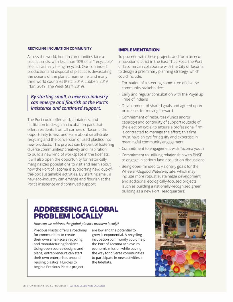
98 | UW URBAN STUDIES PROGRAM | CARR, MCKEEN AND SAUCEDO
Across the world, human communities face a plastics crisis, with less than 10% of all “recyclable” plastics actually being recycled. Our continued production and disposal of plastics is devastating the oceans of the planet, marine life, and many third world countries (Katz, 2019; Lubben, 2019; Irfan, 2019; The Week Staff, 2019).
The Port could offer land, containers, and facilitation to design an incubation park that offers residents from all corners of Tacoma the opportunity to visit and learn about small-scale recycling and the conversion of used plastics into new products. This project can be part of fostering diverse communities’ creativity and inspiration to build a new kind of workspace in the tideflats. It will also open the opportunity for historically marginalized populations to visit and learn about how the Port of Tacoma is supporting new, out-of-the-box sustainable activities. By starting small, a new eco-industry can emerge and flourish at the Port’s insistence and continued support.
RECYCLING INCUBATION COMMUNITY
By starting small, a new eco-industry can emerge and flourish at the Port’s insistence and continued support.
ADDRESSING A GLOBAL PROBLEM LOCALLY
IMPLEMENTATION To proceed with these projects and form an eco-innovation district in the East Thea Foss, the Port of Tacoma can collaborate with the City of Tacoma to design a preliminary planning strategy, which could include:
• Formation of a steering committee of diversecommunity stakeholders
• Early and regular consultation with the PuyallupTribe of Indians
• Development of shared goals and agreed uponprocesses for moving forward
• Commitment of resources (funds and/orcapacity) and continuity of support (outside ofthe election cycle) to ensure a professional firmis contracted to manage the effort; this firmmust have an eye for equity and expertise inmeaningful community engagement
• Commitment to engagement with Tacoma youth
• Commitment to utilizing relationship with BNSFto engage in serious land acquisition discussions
• Being open-minded to visionary goals for theWheeler-Osgood Waterway site, which mayinclude more robust sustainable developmentand additional ecologically-focused projects(such as building a nationally-recognized greenbuilding as a new Port Headquarters)
Precious Plastic offers a roadmap for communities to create their own small-scale recycling and manufacturing facilities. Using open source designs and plans, entrepreneurs can start their own enterprises around reusing plastics. Hurdles to begin a Precious Plastic project
are low and the potential to grow is exponential. A recycling incubation community could help the Port of Tacoma achieve its economic mission while paving the way for diverse communities to participate in new activities in the tideflats.
How can we address the global plastics problem locally?

CHAPTER 7 | ENVIRONMENTAL HEALTH | 99
Industrial partners should heed the call of the public’s changing views on how we interact with the environment. Through implementing a robust environmental demonstration project, the Port of Tacoma can spearhead a project of purpose that community members trust and feel compelled to engage with directly. At the same time, the Port can seek projects that support its local business partners and stakeholders. A project of this magnitude may produce momentum for the Port to form additional innovative partnerships and education/research initiatives and pursue new economic development. Utilizing a community-led design process and locally sourced labor, an eco-innovation district will encourage place attachment bonds to develop between people and the East Thea Foss. This will garner local support for the Port to continue building sustainable systems.
Tacoma is currently on the frontlines of the previously discussed recycling crisis, with the City asking residents for help keeping municipal recycling services viable (Branch, 2019). Community partners, like Spaceworks, have programs to help incubate and support small scale entrepreneurs, and art programs to foster inclusive opportunities for diverse communities (Spaceworks, n.d.). Tacoma Creates is establishing “equity and access to Tacoma’s arts, culture, science, and heritage programs,” by increasing opportunities for youth, providing financial and technical support to communities, and focusing on low-income families and students (City of Tacoma, 2019). Site adjacent industries, like Urban Accessories, are already offering distinct maker-community services and products (Urban Accessories, n.d.). These all stand as potentially powerful partners and allies for the
Port of Tacoma as it decides whether to pursue the endeavor of creating an eco-innovation district. The low barrier costs, learning components, and environmental and economic outcomes of a project like the two we have described can be scaled up to develop a more robust and inclusive community-led initiative. This will generate local trust and a sense of valuing what the Port represents and brings to Tacoma.
As a major institution in the Pacific Northwest with a large sphere of influence, one that expands beyond national lines, the Port of Tacoma has the opportunity to demonstrate its commitment not only to sustainability but to the advancement of social equity and inclusion. The demonstration project we described in this document would fuse the goals of environmental stewardship with the need for innovative and scalable urban industrial and manufacturing businesses. The Port of Tacoma has an opportunity to stand for community access and inclusion, while continuing to accomplish goals related to safeguarding the environment and industrial land uses. The case studies presented in this chapter demonstrate ways the Port of Tacoma and the City of Tacoma can join hands in acknowledging and addressing the environmental health challenges of our time, all while serving the community and advancing the mission of environmental stewardship. Changing the long-standing, and historically negative public perceptions of the Port of Tacoma will not happen overnight; this should not deter us from taking bold action.
CONCLUSIONAs a major institution in the Pacific Northwest with a large sphere of influence, one that expands beyond national lines, the Port of Tacoma has the opportunity to demonstrate its commitment not only to sustainability but to the advancement of social equity and inclusion.
Utilizing a community-led design process and locally sourced labor, an eco-innovation district will encourage place attachment bonds to develop between people and the East Thea Foss.

100 | UW URBAN STUDIES PROGRAM | REFERENCES

APPENDIX | 101
APPENDIX
Arnstein, S. (1969). “A Ladder of Citizen Participation.” Journal of the American Planning Association 35(4): 216-224.
Bluestone, B. & Harrison, B (1982) The deindustrialization of America, New York: Basic Books.
Brown, P. H. (2009). America’s Waterfront Revival: Port Authorities and Urban Redevelopment. Philadelphia, PA, University of Pennsylvania Press.
Curran, W. (2007) “‘From the Frying Pan to the Oven’: Gentrification and the Experience of Industrial Displacement in Williamsburg, Brooklyn,” Urban Studies, Vol. 44, No. 8, 1427– 1440.
Federal Reserve (2019) Industrial Production and Capacity Utilization – G-17. https://www.federalreserve.gov/releases/g17/100_years_of_ip_data.htm (Accessed 8/26/19).
Ferm J., & Jones,E. (2016) “Mixed-use ‘regeneration’ of employment land in the post-industrial city: challenges and realities in London.” European Planning Studies, V.24, N.10, pp.1913-1936.
Forester, J. (1989). Planning in the Face of Power. Berkeley, CA, University of California Press.
Forester, J. (1999). The Deliberative Practitioner: Encouraging Participatory Planning Processes. Cambridge, MA, MIT Press.
Hamnett, C. (2000) Gentrification, postindustrialism, and industrial and occupational restructuring in global cities. In Sophie Watson and Gary Bridge (Eds.) A Companion to the City, Malden: Blackwell.
Hall, P.V. (2009) “Container ports, local benefits and transportation worker earnings.” GeoJournal 74: 67, pp.67-83.
Healey, P. (1997). Collaborative Planning: Shaping Places in Fragmented Societies. Vancouver, BC, University of British Columbia Press.
Hein, C., Ed. (2011). Port cities: Dynamic Landscapes and Global Networks. London, Routledge.
Hoyle, B. (2000). “Global and Local Change on the Port-City Waterfront.” Geographical Review 90(3): 395-417.
Leigh, N.G. & Hoelzel, B. (2012). Smart growth’s blindside: Sustainable Cities Need Productive Urban Industrial Land. Journal of the American Planning Association, 78(1), 87-103.
Lester, T., Kaza, N., & Kirk, S. (2013) Making Room for Manufacturing: Understanding Industrial Land Conversion in Cities, Journal of the American Planning Association, 79:4, 295-313.
Luria, D. and Rogers, J. (2007) Manufacturing, Regional Prosperity, and Public Policy. In R. McGahey and J. Vey (Eds.) Retooling for Growth: Building a 21 st Century Economy in America’s Older Industrial Areas(pp.249-274). Washington, D.C.: Brookings Institution Press.
INTRODUCTION REFERENCES

102 | UW URBAN STUDIES PROGRAM | REFERENCES
Ballantine, A. (2017). The river mouth speaks: water quality as storyteller in decolonization of the Port of Tacoma. Water History. 9:1, 45-66. DOI 10.1007/S12685-016-0179-5.
Blumm, M.C. (2017). Indian Treaty Fishing Rights and the Environment: Affirming the Right to Habitat Protection and Restoration. Washington Law Review. 92:1, 1-38.
Bureau of Transportation Statistics, Maritime Administration, & U.S. Coast Guard. (1999). National Security. Maritime Trade and Transportation. Washington, DC: Department of Transportation.
Carter, N. and Stern, C. (2017). Army Corps of Engineers: Water Resource Authorizations, Appropriations, and Activities. Congressional Research Service. Retrieved from https://fas.org/sgp/crs/misc/R41243.pdf.
City of Tacoma (2013). Shoreline master program. Retrieved from https://cms.cityoftacoma.org/Planning/Shoreline/CityCouncil/Amended/Ord28034Exhibit_A.pdf.
City of Tacoma (2017). Stormwater Management Program Plan. Retrieved from https://cms.cityoftacoma.org/enviro/SurfaceWater/2017%20swmp%20Update_March%202017.pdf.
City of Tacoma (2017). Tideflats Subarea Plan. Retrieved from https://www.cityoftacoma.org/cms/one.aspx?portalId=169&pageId=132602.
City of Tacoma (2019). Tideflats Subarea Planning Work Plan. Retrieved from https://cms.cityoftacoma.org/Planning/Tideflats/Subarea%20Plan/Work%20Plan/Work%20Plan%20-%20Approved%202.8.19.pdf.
CHAPTER 1 REFERENCES
Naim, M. (2014) “America’s coming manufacturing revolution.” The Atlantic Monthly, April 21, 2014.
Parker, E and Rogers, J (2001) Building the high road in metro areas: sectoral training and employment projects. In Lowell Turner, Harry C. Katz, and Richard W. Hurd (Eds) Rekindling the movement: Labor’s quest for relevance in the 21 st Century, Ithaca: Cornell University, ILR Press.
Pressman, J. L. and A. B. Wildavsky (1973, 1984). Implementation. Berkeley, CA, UC Press.
PSRC (2017). Vision 2040, Regional Data Profile. Seattle, WA, Puget Sound Regional Council.
Quick, K. S. and M. S. Feldman (2011). “Distinguishing Participation and Inclusion.” Journal of Education Planning and Research 31(3): 272-290.
Samuelson, R. (2012) “Myths of post-industrial America.” The Washinton Post, April 7, 2013.
Shaw, D. (2001) The Post-Industrial City. In R. Paddison (ed.) Handbook of Urban Studies (pp.284-295). Thousand Oakes: SAGE.
Wolman, H., Stokan, E., & Wial, H. (2015). “Manufacturing Job Loss in U.S. Deindustrialized Regions—Its Consequences and Implications for the Future: Examining the Conventional Wisdom.” Economic Development Quarterly, Vol. 29(2) 102 –112.
INTRODUCTION REFERENCES (continued)

APPENDIX | 103
Eligon, J. (2018, June 11). ‘This Ruling Gives Us Hope’: Supreme Court Sides With Tribe in Salmon Case. The New York Times. Retrieved from https://www.nytimes.com/2018/06/11/us/washington-salmon-culverts-supreme-court.html.
Historic Tribal Consultation Policy Announced in Washington State. (2019, May 10). Native Daily Network. Retrieved from http://www.nativedailynetwork.com/2019/05/aglandmarkconsulttribes/.
Maritime Administration. (2018). National Port Readiness Network (NPRN). Retrieved from https://www.maritime.dot.gov/ports/strong-ports/national-port-readiness-network-nprn
McChord Pipeline CO. (n.d.). About Us. Retrieved from http://www.mcchordpipeline.com/about.html.
Northwest Seaport Alliance. (n.d.). Strategic Plan. Retrieved from https://www.nwseaportalliance.com/about/strategic-plan
Northwest Seaport Alliance. (n.d.). About Us. Retrieved from https://www.nwseaportalliance.com/about
Oldham, K. (2006). Washington Legislature enacts Growth Management Act on April 1, 1990. historylink.org Essay 7759. Retrieved from https://historylink.org/File/7759
Port Compliance.org. (n.d.) Federal Regulations. Retrieved from http://www.portcompliance.org/eparegulations.php#FDA
Port of Olympia (n.d.). What is a Public Port? Retrieved from www.portolympia.com/352/What-is-a-Port
Port of Seattle, Port of Tacoma, and Vancouver Port Authority (2007). Northwest Ports Clean Air Strategy. Retrieved from https://www.portoftacoma.com/sites/default/NW%20PORTS%CLEAN%AIR%20STRATEGY_FINAL_DEC07.pdf
Port of Tacoma (2014). Land Use and Transportation Plan. Retrieved from: https://www.portoftacoma.com/sites/default/files/attachments/LandUseTransportationPlan2014.pdf
Port of Tacoma (2019). Port of Tacoma 2018 Budget [Ebook]. Retrieved from http://file:///C:/Users/rtste/OneDrive/Desktop/FINAL%202018%20POT%20Budget%20Document%2012-11-17.pdf
Transportation and Infrastructure Committee. (1994, updated 2009). Comprehensive Plan Guideline for Washington’s Public Ports. Retrieved from https://static1.squarespace.com/static/5a8499e518b27dc83c2403ce/t/5b4fc00d575d1fc08b9d830c/153195165960/Comprehensive-Plan-Guidebook1/pdf
Votteler, T.H. & Muir, T.A. (2002). Wetland Protection Legislation. [online] Retrieved from https://water.usgs.gov/nwsum/WSP2425/legislation.html
US Fish and Wildlife Service. (n.d.). Rivers and Harbors Appropriation Act of 1899. Retrieved from Digest of Federal Resource Laws of Interest to the U.S. Fish and Wildlife Service: https://www.fws.gov/laws/lawsdigest/riv1899.html
US Government Accountability Office. (2013). Defense Logistics: The Department of Defense’s Report on Strategic Seaports Addressed All Congressionally Directed Elements. Retrieved from https://www.gao.gov/products/GAO-13-511R
CHAPTER 1 REFERENCES (continued)

104 | UW URBAN STUDIES PROGRAM | REFERENCES
ArcGIS Web Application. (2019). Retrieved from https://wspdsmap.cityoftacoma.org/website/PDS/Zoning/
Brown, P. H. (2009). America’s Waterfront Revival: Port Authorities and Urban Redevelopment. Philadelphia: University of Pennsylvania Press.
Commission, T. (2019). Transportation Mater Plan [PDF] (p. 2). Tacoma: City of Taocma. Retrieved from https://cms.cityoftacoma.org/PublicWorks/Engineering/TMP/TacomaTMP_FINAL_Oct15th_2015_modal%20map%20excerpts_freight.pdf.
City of Tacoma. (2017). The Thea Foss Waterway Design Guidelines. Community and Economic Development Department. Accessed on March 3rd 2019 at https://cms.cityoftacoma.org/Planning/Shoreline/CityCouncil/Amended/Res38375Exhibit_A.pdf.
Celik, Kelvin. “Problems emerged from Urban Area Presentation of Agricultural Lands,” Turkey Cartography Scientific and Technical Council. 2010.
City of Tacoma (n.d.). One Tacoma: Comprehensive Plan. Web https://www.cityoftacoma.org/cms/one.aspx?pageId=15801. Accessed 2 Mar 2019.
Demirel, Ziglar. (2014) “Land Management and its effects on our Profession Changes.” Magazine,Ankara.
Esina, Erick. (2009) “A study about setting Land Management Unit in Turkey SU.” Master Thesis, Konya.
Entrata, Inc. (2019). Our Floor Plans. Retrieved March 14, 2019, from Albers Mill Lofts: https://www.albersmilllofts.com/tacoma/albers-mill-lofts-apartments/
Foss Waterway Development Authority. (2014). Imagine Your Project in Tacoma’s Growing Waterfront Community. Retrieved from Foss Waterway Development Authority: https://www.theafoss.com/
Future Land Use Implementation - City of Tacoma. (2019). Retrieved from https://www.cityoftacoma.org/government/city_departments/planning_and_development_services/planning_services/current_initiatives_and_projects/future_land_use_implementation.
Garvin, A. (2014). The American city : what works, what doesn’t. New York: McGraw-Hill Education.
GeoEngineers. (2014). Site-Specific Cleanup Action Plan (SCAP). Foss Waterway Development Authority. File No. 10751-011-00.
Goksu, Alfred. “Transfer of construction right concept and assessment of right transfer application device in new law.” Ankara.
Karakurt,Tank. (2009) “Concept of sustainability and its effects on urban structure.” Paradox Economy, sociology and policy magazine.
Leigh, N., & Hoelzel, N. (2012). Smart Growth’s Blind Side. Journal Of The American Planning Association, 78(1), 87-103. doi: 10.1080/01944363.2011.645274.
Leigh, N., Hoelzel, N., Kraft, B., & Dempwolf, S. (2014). Sustainable urban industrial development.
Malloy, R. (2018). Land use and zoning law : planning for accessible communities. Durham, North Carolina: Carolina Academic.
Port of Tacoma. (n.d.). History. Retrieved from portoftacoma.com: https://www.portoftacoma.com/100
Port of Tacoma. (n.d..). Port of Tacoma’s Centennial - 100 years. A million stories.
CHAPTER 2 REFERENCES

APPENDIX | 105
Retrieved from Port of Tacoma: https://pot.maps.arcgis.com/apps/MapSeries/index.html?appid=5cead9e072cb47a0ac723ed067f85682.
Puyallup Watershed Initiative |COI - Active Transportation - Tacoma to Puyallup. (2019). Retrieved from https://www.pwi.org/index.cfm?fuseaction=Page.ViewPage&PageID=622
Saban Inam., and Mehmet Ertas. (2012) “The Importance of The Urban Land Policy For Sustainable Development, Problems And Solution Recommendations.” Planning, Environment and Tourism.
Talen, E. (2012). City rules : how regulations affect urban form. Washington, DC: Island Press.
Tacoma Planning Commission. (2005). Thea Foss Waterway Design and Development Plan. Tacoma City Council. Accessed on March 3rd 2019 at https://cms.cityoftacoma.org/Planning/Dome-Brewery%20Subarea/Thea%20Foss%20Waterway%20Design%20and%20Development%20Plan%2011-15-05.pdf.
The Northwest Seaport Alliance. (2019, February 22). NWSA handles record container volumes in January. Retrieved from The Northwest Seaport Alliance: https://www.nwseaportalliance.com/stats-stories/cargo-stats/2222019/nwsa-handles-record-container-volumes-january
Thea Foss Waterway. (2019). Retrieved from https://en.wikipedia.org/wiki/Thea_Foss_Waterway
U.S. Environmental Protection Agency. (2019). Restoring and Revitalizing Waterfront Resources: Tacoma’s Thea Foss Waterway [Ebook] (p. 8). Tacoma. Retrieved from https://semspub.epa.gov/work/HQ/196400.pdf.
Washington State Department of Ecology. (n.d.). Tacoma Redevelopment Prop. Retrieved from Washington State Department of Ecology: https://fortress.wa.gov/ecy/gsp/Sitepage.aspx?csid=3677
CHAPTER 2 REFERENCES (continued)
Charmaz, K. (2014). Constructing Grounded Theory (2nd edition). London: Sage Publications Ltd.
Devine-Wright, P. (2013). Dynamics of place attachment in a climate-changed world. Place Attachment: Advances in Theory, Methods and Applications. 165-177. 10.4324/9780203757765.
Low S.M., Altman I. (1992). Place Attachment. In: Altman I., Low S.M. (eds) Place Attachment. Human Behavior and Environment (Advances in Theory and Research), vol 12. Springer, Boston, MA. DOI: https://doi.org/10.1007/978-1-4684-8753-4_1
Manzo, L. C. & Perkins, D. D. (2006). Finding common ground: the importance of place attachment to community participation and planning. Journal of Planning Literature, Vol. 20, No. 4. Sage Publications. DOI: 10.1177/0885412205286160.
Scannell, L. & Gifford, R. (2009). Defining place attachment: a tripartite organizing framework. Journal of Environmental Psychology, vol. 30: 1. https://doi.org/10.1016/j.jenvp.2009.09.006
CHAPTER 3 REFERENCES

106 | UW URBAN STUDIES PROGRAM | REFERENCES
350 Seattle. (2017). No LNG in 253. YouTube. Retrieved on Jun 1, 2019 from https://youtu.be/42JrMne_TwE.
Isabelle Anguelovski. (2013) New Directions in Urban Environmental Justice: Rebuilding Community, Addressing Trauma, and Remaking Place. Journal of Planning Education and Research 33(2) 160–175.
Bullard, Robert, Ed. (2007) Growing Smarter: Achieving Livable Communities, Environmental Justice, and Regional Equity. Cambridge, MA: MIT Press.
Campbell, Scott. (1996). Green Cities, Growing Cities, Just Cities? Urban Planning and the Contradictions of Sustainable Development. Journal of the American Planning Association 62(3) 296-312.
Charmaz, K. (2014). Constructing Grounded Theory 2nd Edition. SAGE Publications Ltd.
Sandercock, L. (1998). Making the invisible visible. Framing Insurgent Historiographies for Planning. Berkeley and Los Angeles, California: University of California Press.
Sugrue, Thomas J. (1996). The origins of the urban crisis: race and inequality in postwar Detroit. Princeton University Press. Retrieved Jan 11, 2019 from https://hdl-handle-net.offcampus.lib.washington.edu/2027/fulcrum.js956f85s.
MAPS
Redline Map. Martin, K. (2019). How racism kept black Tacomans from buying houses for decades. The News Tribune. Retrieved June 5, 2019 from https://www.thenewstribune.com/news/business/real-estate-news/article216269965.html
Tacoma Equity Map. City of Tacoma. Community attributes inc. Retrieved on June 6, 2019 from https://caimaps.info/tacomaequitymap?location=Tacoma&tab=demo&searchType=city&fbclid=IwAR1GjEHd8RrLpVjweh0MXdLf1uFZJcwKlknbxy3f8yL5-ZqWXPTY7H4MJ-Y&layer=EquityLayer
RCW 90.58 (1971) Shoreline Management Act of 1971.
Sax, Joseph (1970). The Public Trust Doctrine in Natural Resource Law: Effective Judicial Intervention. Michigan Law Review. 68 (3): 471-566.
Tacoma, WA (2013). Tacoma Shoreline Master Program.
CHAPTER 4 REFERENCES
CHAPTER 5 REFERENCES

APPENDIX | 107
Acciaro, M., Ghiara, H., & Cusano, M. I. (2014). Energy management in seaports: A new role for port authorities doi://doi.org/10.1016/j.enpol.2014.04.013
Bocken, N., Rana, P., & Short, S. W. (2015). Value mapping for sustainable business thinking. Journal of Industrial and Production Engineering, 32(1), 67-81.
Brundtland, G. (1987). Our common future [PDF format]. Retrieved from http://www.undocuments.net/our-common-future.pdf
Cale, A. (2018). How racially equitable are the outcomes of sustainability planning? Access*: Interdisciplinary Journal of Student Research and Scholarship, 2(1), Article 3.
Clark, J., & Clavel, P. (2012). Introduction to the special issue on manufacturing. Progressive Planning, 190.
Community Attributes Inc. (2019). Port of Seattle, Port of Tacoma, and the Northwest Seaport Alliance economic impact analysis.
Department of Commerce Washington State. (2016). Proposed strategic plan for Washington state: Maritime Sector 2017 – 2019. Office of Economic Development & Competitiveness
Fonseca, L. (2018). Industry 4.0 and the digital society: Concepts, dimensions and envisioned benefits. Proceedings of the International Conference on Business Excellence, 12(1), 386-397.
Giloth, R. (2012). Planners and manufacturing: An uneasy alliance. Progressive Planning, 190.
Gonzalez, G.C., Singh, R., Karam, R., & Ortiz, D. (2014). Energy-Sector Workforce Development in Southwestern Pennsylvania. Aligning Education and Training with Innovation and Needed Skills. Rand Corporation. https://www.rand.org/pubs/research_reports/RR807.html
https://www.rand.org/pubs/research_reports/RR807.html
Green Leigh, N., & Hoelzel, N. (2015). Sustainable urban industrial development. Routledge: New York: American Planning Association.
Harnack, L. (2010). Workforce Development: Planning for the Future. https://www.masstransitmag.com/management/article/10168124/planning-for-the-future
HB 1568, 2019 Biennium, 2019 Reg. Sess. (Wash. 2019).
Hecklau, F., Galeitzke, M., Flachs, S., & Kohl, H. (2016). Holistic approach for human resource management in Industry 4.0. Procedia Cirp, 54, 1-6.
Hendee Brown, P. (2009). America’s waterfront revival: Port authorities and urban redevelopment. Philadelphia: University of Pennsylvania Press.
Leigh, N. G., & Hoelzel, N. Z. (2012). Smart growth’s blind side: Sustainable cities need productive urban industrial land. Journal of the American Planning Association, 78(1), 87-103. doi:10.1080/01944363.2011.645274.
McGraw, P. (2019). New Washington laws give ports greater role in economic, environmental and community development. Port of Seattle Retrieved from https://www.portseattle.org/news/new-washington-laws-give-ports-greater-role-economic-environmental-and-community-development
CHAPTER 6 REFERENCES

108 | UW URBAN STUDIES PROGRAM | REFERENCES
Müller, J. M., Kiel, D., & Voigt, K. (2018). What drives the implementation of industry 4.0? the role of opportunities and challenges in the context of sustainability. Sustainability, 10(1), 247.
Nank, R., & Alexander, J. (2012). FAREWELL TO TOCQUEVILLE’S DREAM: A CASE STUDY OF TRADE ASSOCIATIONS AND ADVOCACY. Public Administration Quarterly, 36(4), 429-461.
Nolan, C., Morrison, E., Kumar, I., Galloway, H., & Cordes, S. (2011). Linking Industry and Occupation Clusters in Regional Economic Development. Economic Development Quarterly, 25(1), 26-35.
Portland Business Alliance. About the Alliance. Retrieved from https://portlandalliance.com/about/
RAIN Incubator. About us. Retrieved from https://www.rainincubator.org/
Schaltegger, S., Lüdeke-Freund, F., & Hansen, E. G. (2016). Business models for sustainability: A co-evolutionary analysis of sustainable entrepreneurship, innovation, and transformation. Organization & Environment, 29(3), 264-289.
Manufacturing Industrial Council for the South Sound. (2018). Stand up for South Sound industry. Pamphlet.
Slaper, T. (2014). Clustering occupations. Indiana Business Review, 89(2), 7.
Stock, T., & Seliger, G. (2016). Opportunities of sustainable manufacturing in industry 4.0. Procedia Cirp, 40, 536-541.
UPROSE. (2019). Industrial retention: Principles for industrial development and climate resilience on the Sunset Park waterfront. Accessed from https://www.uprose.org/industrial-retention.
Urban Manufacturing Alliance. (2019). Urban manufacturing alliance. Accessed from https://www.urbanmfg.org/.
Zhao, Xu, Wall, & Stavropoulos. (2017). Building a bridge between port and city: Improving the urban competitiveness of port cities. Journal of Transport Geography, 59, 120-133.
CHAPTER 6 REFERENCES (continued)

APPENDIX | 109
About » B Corps. Retrieved from https://bcorporation.net/about-b-corps
About » ReefCells. Retrieved from http://www.reefcells.com/
About » World Port Sustainability Program. Retrieved from https://sustainableworldports.org/about/
Architectural metal castings since 1972. Retrieved from http://www.urbanaccessories.com/
Asarco smelter site on the Ruston Way waterfront, Tacoma Landfill site on Commencement Bay and Citizens for a Healthy Bay.
Becker, Austin, et al. (2012). Climate change impacts on international seaports: knowledge, perceptions, and planning efforts among port administrators. Climate Change, 10(1-2), 5-29.
Branch, Zoe. (2019, March 19). The Changing Face of Recycling. Retrieved from https://southsoundmag.com/the-changing-face-of-recyling/
Brown, P. H. (2009). America’s waterfront revival: Port authorities and urban redevelopment. Philadelphia: University of Pennsylvania Press.
Bulley, D. (2013). Producing and governing community (through) resilience. Politics, 33(4), 265-275.
Checker, Melissa. (2011). Wiped Out by the “Greenwave”: Environmental Gentrification and the Paradoxical Politics of Urban Sustainability. City & Society, 23(2), 210–229.
City of Tacoma. Tacoma Creates. Retrieved from https://www.cityoftacoma.org/cms/one.aspx?pageId=169949
Declaration » World Port Sustainability Program. Retrieved from https://sustainableworldports.org/wp-content/uploads/wpsp-declaration.pdf
Girard, Luigi Fusco. (2010). Sustainability, creativity, resilience: Toward new development strategies of port areas through evaluation processes. Int. J. of Sustainable Development, 13(1/2), 161-184.
Irfan, Umair. (2019, May 25). The alarming trend of beached whales filled with plastic, explained. Retrieved from https://www.vox.com/2019/5/24/18635543/plastic-bags-whale-stomach-beached
Katz, Cheryl. (2019, March 13). The World’s Recycling is in Chaos. Here’s what has to happen. Retrieved from https://www.wired.com/story/the-worlds-recycling-is-in-chaos-heres-what-has-to-happen/
Lubben, Alex. (2019, May 30). We’re buying into a giant lie about plastic. Retrieved from https://news.vice.com/en_us/article/xwn4mj/were-buying-into-a-giant-lie-about-plastic?utm_source=vicenewsfacebook
Manchester Stormwater Retrofit Project. Retrieved from http://kitsap.paladinpanoramic.com/project/2231/44030
Martin, Brittany. (2019, May 25). If they build it, will the oysters come?. Retrieved from https://www.washingtonpost.com/national/health-science/if-they-build-it-will-the-oysters-come/2019/05/25/e0563daa-7cb5-11e9-a5b3-34f3edf1351e_story.html?noredirect=on&utm_term=.3ae8ef98d955
MultiCare Health System, CHI Franciscan, and Kaiser Permanente
Nace, T. (2017, July 26). We’re Now At A Million Plastic Bottles Per Minute - 91% Of Which Are Not Recycled. Forbes. Retrieved from https://www.forbes.com/sites/trevornace/2017/07/26/million-plastic-bottles-minute-91-not-recycled/#7c92d786292c
CHAPTER 7 REFERENCES

110 | UW URBAN STUDIES PROGRAM | REFERENCES
Nancey Green Leigh & Nathanael Z. Hoelzel. (2014). Sustainable Urban Industrial Development. PAS Report 577. APA Planning Advisory Service.
New Heaven Reef Conservation. Retrieved from https://newheavenreefconservation.org/marine-blog/147-artificial-reefs-what-works-and-what-doesn-t
Nilsen, Ella. (2019, June 5). Climate change is becoming a defining issue of 2020. Retrieved from https://www.vox.com/2019/6/5/18652787/climate-change-2020-ocasio-cortez-biden-warren
Point Defiance: Protecting Puget Sound. Retrieved from https://www.cityoftacoma.org/government/city_departments/environmentalservices/surface_water/green_stormwater_infrastructure__gsi_/gsi_projects/point_defiance_regional_stormwater_treatment_facil
Programs » Spaceworks Tacoma. Retrieved from https://www.spaceworkstacoma.com/programs/
Reefs » Billion Oyster Project. Retrieved from https://billionoysterproject.org/reefs/
Tacoma Pierce County Health Department. (2018). 2018 Community Health Department. In . (Ed.). Tacoma, WA: Tacoma Pierce County Health Department.
The Blocker » ByFusion. Retrieved from https://www.byfusion.com/the-blocker/
The Foss Waterway Cleanup. Retrieved from https://www.cityoftacoma.org/government/city_departments/environmentalservices/surface_water/restoration_and_monitoring/thea_foss_waterway_cleanup
The Gowanus Lowlands » Scape Studios. Retrieved from https://www.scapestudio.com/projects/oyster-tecture/
The Pittsburgh EcoInnovation District: Uptown and Oakland. Retrieved from http://www.ecoinnovationdistrict.org/
The Week Staff. (2019, March 30). The recycling crisis. Retrieved from https://theweek.com/articles/831864/recycling-crisis
Thornton, R. L., et al. (2016). Evaluating strategies for reducing health disparities by addressing the social determinants of health. Health Affairs, 35(8), 1416-1423.
Watts, Jonathan. (2018, October 8). We have 12 years to limit climate change catastrophe, warns UN. Retrieved from https://www.theguardian.com/environment/2018/oct/08/global-warming-must-not-exceed-15c-warns-landmark-un-report
Workspaces » Precious Plastics. Retrieved from https://preciousplastic.com/en/workspaces.html
World Port Sustainability Program (n.d.). Retrieved from https://sustainableworldports.org/
CHAPTER 7 REFERENCES (continued)

APPENDIX | 111

FALL 2019
URBAN WATERFRONTS AND PLANNING FOR INDUSTRY
SCHOOL OF URBAN STUDIES