Urban Land Use Transformation Driven by an Innovative ... · Luis Eduardo Tafur is a Civil Engineer...
20
Juan Pablo Bocarejo is a Civil Engineer with an Msc from Université Paris XII – Ecole Nationale de Ponts et Chaussées and PhD from Université Paris Est. He has undertaken consultancies on public transport and non-motorized systems in developing countries for more than 15 years. He is a professor at Universidad de Los Andes in Bogotá and director of the Research Group on Regional and Urban Sustainability (SUR). Contact: [email protected]. Luis Eduardo Tafur is a Civil Engineer and MSc from Universidad de Los Andes. His M.Sc. research was a simulation of land use impacts of suburban train on Bogotá region and suburban municipalities. Urban Land Use Transformation Driven by an Innovative Transportation Project, Bogotá, Colombia Juan Pablo Bocarejo and Luis Eduardo Tafur Case study prepared for Global Report on Human Settlements 2013 Available from http://www.unhabitat.org/grhs/2013
-
Upload
duongnguyet -
Category
Documents
-
view
215 -
download
0
Transcript of Urban Land Use Transformation Driven by an Innovative ... · Luis Eduardo Tafur is a Civil Engineer...

Juan Pablo Bocarejo is a Civil Engineer with an Msc from Université Paris XII – Ecole Nationale de Ponts et Chaussées and PhD from Université Paris Est. He has undertaken consultancies on public transport and non-motorized systems in developing countries for more than 15 years. He is a professor at Universidad de Los Andes in Bogotá and director of the Research Group on Regional and Urban Sustainability (SUR). Contact: [email protected]. Luis Eduardo Tafur is a Civil Engineer and MSc from Universidad de Los Andes. His M.Sc. research was a simulation of land use impacts of suburban train on Bogotá region and suburban municipalities.
Urban Land Use Transformation Driven by an Innovative Transportation Project,
Bogotá, Colombia
Juan Pablo Bocarejo and Luis Eduardo Tafur
Case study prepared for
Global Report on Human Settlements 2013
Available from http://www.unhabitat.org/grhs/2013

Disclaimer: This case study is published as submitted by the consultant, and it has not been edited by the United Nations. The designations employed and the presentation of the material in this publication do not imply the expression of any opinion whatsoever on the part of the Secretariat of the United Nations concerning the legal status of any country, territory, city or area, or of its authorities, or concerning delimitation of its frontiers or boundaries, or regarding its economic system or degree of development. The analysis, conclusions and recommendations of the report do not necessarily reflect the views of the United Nations Human Settlements Programme, the Governing Council of the United Nations Human Settlements Programme or its Member States. Nairobi, 2011

Urban Land Use Transformation Driven by an Innovative Transportation Project, Bogotá, Colombia
Juan Pablo Bocarejo and Luis Eduardo Tafur
Introduction For the last 15 years Bogotá has been perceived as an interesting case when considering urban issues. The positive changes experienced by this city of eight million people in just a decade have raised international interest from policy makers, researchers and multilateral institutions. The perception about Bogotá changed from an example of failed city to an example of a sustainable and promising one.
The main symbol of this change is indisputably the BRT system called TransMilenio. Designed and built in a very short time (3 years), considering that the city had been developing metro studies for decades before (Guhl and Pachón, 1992), TransMilenio is the most visible physical change, but it is also said to have influenced other aspects of Bogotá’s structure and bogotanos life, such as land use, productivity, road fatalities, even crime and health issues.
However, the mutual impacts between land use and transport in Bogotá in the last two decades have also been influenced by other elements such as the creation of a regulatory frame for urban planning that provided new public instruments, an improvement of local institutions, a transport policy that prioritized public transport over car infrastructure, and a political and economic context that promoted a dense, transit oriented city. In fact, in the last decade of the twentieth century, Colombian people felt the need to remain inside cities because of security issues, preventing sprawl, and a low economic growth which contributed to low levels of motorization.
For a number of developing cities, in a similar situation, Bogotá has been an interesting example. Officials from Latin American, but also from Asian, African and even from some North American cities have come to learn about the Bogotá ‘miracle’. In terms of land use/transport links, it serves as a rare and quite useful ‘laboratory’, as it enables the evaluation of changes after a new mass transit system is introduced for the first time in the main corridors of the city.
This case study reviews some of the main findings of prior research on land use/transport interactions and land use regulation. It also assesses the impact on accessibility, especially for the poor. Finally, it presents some of the new dilemmas that Bogota is now facing as a wealthier city with a faster motorization growth: sprawl, new challenges related to transit network investments and the financing of transport projects.
Background Bogotá is a very dense and socially segregated city with 7.5 million inhabitants living inside the Distrito Capital, the political limit of the city. An additional million live in satellite municipalities, in a de facto Metropolitan Area with no institution directly in charge. Density inside the Distrito Capital is close to 14,000 inhabitants per square kilometre.
Over the last decades, the complex political situation of Colombia has contributed to large migratory flows to the capital, where security, health and educational services are well above the rest of the country, resulting in a high urban population growth rates. The last two decades had annual growth rates close to 2 per cent. As shown in Table 1, population growth in the Urban Land Use Transformation Driven by an Case study prepared for the Innovative Transportation Project, Bogotá, Colombia Page 3 of 20 Global Report on Human Settlements 2013

next decades will be faster in the suburban areas. It should reach a total of 12.5 million inhabitants by 2040.
Table 1. Population of Greater Bogotá (millions) 2010 2020 2040 Bogotá Capital District 7.36 8.38 10.83
Suburban municipalities 0.91 1.14 1.78
TOTAL 8.27 9.52 12.51
Source: Acevedo et al, 2009, with DANE information.
Bogotá contributes generates a quarter of the national GDP. Its population is divided into 6 socioeconomic strata according to the National Department of Statistics (DANE). This division is used to establish public service fares and provide different kind of subsidies. As shown in Table 2, half of the population falls in the lower income categories, with a monthly income close to US$140.
Table 2. Population of Greater Bogotá (millions)
STRATA % of total population Monthly income per capita (US$ 2004)
1 – Lower income 13 99 2 – Lower income 38 141 3 – Middle income 39 279 4 – Middle income 7 690 5 – Higher income 2 1,147 6 – Higher income 1 1,501 Source: Authors based on surveys from Secretaría de Hacienda de Bogotá.
Bogotá presents a clear spatial segregation whereby low-income groups are settled in the periphery far away from the CBD, as can be seen in Figures 1 and 2. The spatial distribution of activities and access to transport modes also reveal inequalities. Rich people live close to the centres of activity in the north of the city while poorer people live in the periphery, in the south and west of the city.
Furthermore, lower income groups have limited mobility (half of that of higher income groups); they spend nearly 20 per cent of their income in transportation costs (Bocarejo, 2007), spend 20 per cent more time and travel longer distances than the higher income groups (Secretaría Distrital de Movilidad, 2005).
For an average low-income household, half of the monthly expenditure in transportation accounts for the payment of all the other public services, leaving 70 per cent of the remaining income for housing, food and other needs (Bocarejo, 2007).
This fact underlines a new challenge for Bogotá’s transportation policy and strategy: accessibility and affordability must be considered as one of the main objectives of future plans. As will be shown later in this study, equity issues are usually present when the plans are proposed. Nevertheless, there are no specific indicators and efforts to measure their performance in this specific area. Urban Land Use Transformation Driven by an Case study prepared for the Innovative Transportation Project, Bogotá, Colombia Page 4 of 20 Global Report on Human Settlements 2013

Figure 1. Employment distribution in Bogotá (2003)
Source: Authors elaboration based on DANE information. Figure 2. Distribution of population according to level of income
Note: Strata 5 and 6 included in category number 5.
Urban Land Use Transformation Driven by an Case study prepared for the Innovative Transportation Project, Bogotá, Colombia Page 5 of 20 Global Report on Human Settlements 2013

Because of the limited purchasing power of the population, 70 per cent of motorized trips in Bogotá were made with public transport modes in 2005 (15 per cent by TransMilenio and 55 per cent by the traditional bus system) as the motorization rate is under 10 cars per one hundred persons (Secretaría Distrital de Movilidad, 2005).
A minority had access to private cars, with a plate restriction system for 40 per cent of the total fleet each day. However, additional surveys showed that 10 per cent of TransMilenio users had the option to use a car.
This situation is changing rapidly. In the last 5 years the number of cars has doubled while the number of motorbikes increased by 500 per cent (Camara de comercio de Bogotá and Universidad de los Andes, 2010).
A recent prospective study has developed a forecast on car ownership and its possible impact on modal distribution, using a model linking income with motorization (Acevedo et al, 2009). The result is that every decade the number of cars will double, generating an inversion of the actual modal distribution, as in the case of Santiago de Chile where in 10 years, between 1991 and 2001, the percentage of private car trips increased from 20 per cent to 40 per cent. The high growth in car ownership implies that in the next 30 years, the number of trips made by car will be higher that the ones made in public transport.
The rate of increase in car ownership has been higher in recent years. A comparison between results of modal share from trip surveys in 1996 and 2005 shows that in that period this share remained stable.
Prior to TransMilenio, Bogotá seemed to be condemned to deficient transit; with the initial success of the system, transport and urban planning and policies aimed towards a transit oriented city; however, with the rapid growth of private vehicle ownership, development of suburban areas, and difficulties faced expanding mass transit system, this could be changing.
In the same way that it is possible to identify a mismatch between the plans and the new patterns in urban mobility, it is also worth noticing that land use plans tend to ignore the way new residential areas and activities develop, with a higher intensity in the suburbs.
Tables 3 and 4 show the evolution of residential location in the last four decades. A pattern where households leave the city centre and settle in the outer parts of the city appears. However, this decrease of population in the centre slows down in the nineties, as a Plan trying to revitalize this area is proposed.
Table 3. Annual population growth rates, Bogotá District center and external rings
Bogotá zone Annual
growth rate (1973-1985)
Annual growth rate (1985-1993)
Annual growth rate (1993 -2005)
City Centre: Candelaria, Chapinero, Santafe, Teusaquillo
0.53 -0.23 0.18
First ring: Barrios Unidos, San Cristobal, Mártires, Fontibón, Tunjuelito, Rafael Uribe, Puente Aranda, Antonio Nariño
1.43 1.38 0.37
External ring: Bosa, Usme, Ciudad Bolivar, Usaquén, Suba, Engativá Kennedy
16.75 3.40 3.42
Total Bogotá population growth rate 5.89 2.3 2.14 Source: Authors with information from DANE.
Urban Land Use Transformation Driven by an Case study prepared for the Innovative Transportation Project, Bogotá, Colombia Page 6 of 20 Global Report on Human Settlements 2013

Figure 3. Bogotá District zones: city centre, first ring and external ring
Source: Authors with information DANE.
Table 3. Evolution of residential location in Bogotá % of Bogotá DC total population by urban zone Year 1973 1985 1993 2005 City Centre 14.85 9.25 7.05 5.73
First Ring 55.10 37.79 34.51 28.65
External Ring 30.04 52.96 58.43 65.53
Source: Authors with information DANE.
A similar evolution is shown in a map of Bogotá City (Figure 4). Each colour represents a set of Bogotá’s localities, corresponding to the Bogotá Zones presented on Table 3.
Urban Land Use Transformation Driven by an Case study prepared for the Innovative Transportation Project, Bogotá, Colombia Page 7 of 20 Global Report on Human Settlements 2013
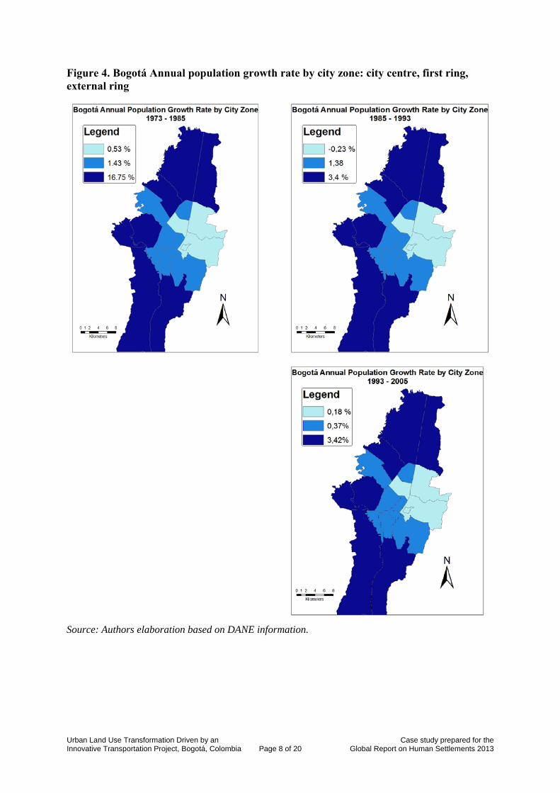
Figure 4. Bogotá Annual population growth rate by city zone: city centre, first ring, external ring
Source: Authors elaboration based on DANE information.
Urban Land Use Transformation Driven by an Case study prepared for the Innovative Transportation Project, Bogotá, Colombia Page 8 of 20 Global Report on Human Settlements 2013

Land use and transport planning in Bogotá Colombia carried out an ambitious decentralisation process in the middle of the nineteen eighties. Mayors and governors previously chosen by the president of the Republic are since then elected by universal vote. They become the authority in charge of the economic, social and environmental development of their territory. They acquire responsibilities in policy definition, planning and development of projects in land use, transportation, health, environment, education, public services and other relevant domains in their territory. In each case, they have to act under a general legal frame defined at a national level.
Institutions Distrito Capital covers a large part of the conurbation. However, satellite municipalities have their own Mayors and there is no single institution charged with ‘metropolitan’ matters.
Bogotá’s Mayor has jurisdiction only inside the Capital District. However, in this wide area, he has the power to undertake the most important interventions. Although at a local scale Bogota has 20 ‘minor’ mayors, they are chosen by the Mayor of Bogotá and their responsibilities and budget are limited.
Plans / Tools Several land use plans have been proposed, since the first decades of the twentieth century, many being more ‘academic’ than really operational. Visions of the city by prestigious architects such as Lecorbusier, in the 1950s, proposed The Bogotá Pilot Plan (Lecorbusier, 1951). Lecorbusier’s Plan was an urban and policy instrument intended for a long term of 50 years. The plan aimed at a segregation of uses within the city. It was never adopted officially.
In the 1970s the idea of a decentralised city, ‘cities inside the city’ was also promoted. At that time, one of the most important studies of Bogotá and its region was undertaken: Urban Development Study of Bogotá, Phase II (Estudio de desarrollo urbano de Bogotá, Fase II) (Llewelyn Davies Weeks et al, 1972). Before Phase II, Phase I (1969) was a study of several of Bogota’s planning alternatives funded by United Nations, which focused on the relation between transport and urban shape. It gave special attention to regional policy, road plan, and institutional structure for Bogotá and its neighbour towns. At that time, 70 per cent of the employment was concentrated in the CBD.
Densification, decentralization of activities in five multi centres, and less concentrated development for a more efficient city, were some of the ideas proposed by the Phase II study. The study looked at 25 towns in region and forecast that the main expansion of Bogotá would take place towards the southwest. However, although such proposals were never brought into practice and the study recommendations were never materialized, they later on became the basis for most of the city development projects.
Probably inspired by the Urban American model, what was developed in detail was the Road Plan; space for future road infrastructure was guaranteed and according to the kind of infrastructure proposed, densities and uses were defined. Some urban historians state that Bogotá’s urban development has been mostly illegal, especially housing for low-income households, having, also illegal, bus transportation services as a strong support.
One of the most dramatic examples that illustrate the absence of a city vision by Bogotá authorities is the Master Plan of Transportation developed by the Japanese International Cooperation Agency (JICA) in 1996. Japanese specialists in charge of the Plan, never
Urban Land Use Transformation Driven by an Case study prepared for the Innovative Transportation Project, Bogotá, Colombia Page 9 of 20 Global Report on Human Settlements 2013

received a clear answer on how the city would grow. They finally proposed a metro line in the northern part of the city; eventually this zone was declared a protected environmental zone, where no residential areas could develop.
Land use law and other key legal improvements Some legal actions developed in the 1990s reinforced the governability of the city, providing useful tools. In particular the ‘Estatuto Orgánico’ provided a new organization of the Distrito Capital, giving more autonomy to the executive power, contributing to a better fiscal organization; similarly, a National Land Use Law was also introduced.
Called The Territory Development Law, it was created for harmonizing the former legislation with the norms stated by 1991 Colombian Constitution. It commands every municipality and district to autonomously develop long term plans. To accomplish this, the Law created the Land Use Plan (POT).
Land use plans (POT) and master plan A POT defines the vision of the city and the main strategies to reach it. It is aimed at organizing the territory according to an economic, social, cultural, and environmental development expectation. Through POTs, the government intends to create proper conditions to make equitable and productive cities.
POTs are the main tool for defining the land use developments and to solve the existing problems around it. The law was issued in 1997. Bogotá´s first POT was developed under Enrique Peñalosa´s administration and completed at the same time with TransMilenio in 2000.
Master plans and mobility In coordination with a POT, cities must produce Master Plans for a number of sectors, including Transportation. The Master Plan of Mobility of Bogotá was issued in 2006. Being a consequence of a POT, it explicitly states that the Mobility Plan and the overall land use plan are coherent and complementary.
It defines the policy, strategies, programs, projects, goals, and defines the general rules to reach a safe, equitable, and sustainable mobility for Bogotá and the region with limited impact on environment and health, aiming to support economic development. Considerations of land use-transport interaction, decentralization, accessibility, coordination, financial sustainability, and environment were included in the plan. The proposed plan is clearly in a path of sustainable mobility, as it is usually understood in ‘Best Practices’. Priority should be given to public transport and non motorized mobility, to more vulnerable citizens, to clean technologies.
TransMilenio and Sustainable Mobility Policies Mobility has recurrently been considered a major problem in Bogotá. For decades, national and local governments struggled to develop a metro, as one of the main strategies to improve the situation. Like in other Latin American cities, Bogotá had the idea of completing a first rail transit line, of 20 to 30 km. At least five big projects and other minor initiatives have been led since the 1980s in order to develop a first metro line. Incomplete studies, mismatch
Urban Land Use Transformation Driven by an Case study prepared for the Innovative Transportation Project, Bogotá, Colombia Page 10 of 20 Global Report on Human Settlements 2013

between transport solutions and urban vision, financial unfeasibility, political decisions and poor managing got in the way.
The completion of the first phase of TransMilenio in just three years (1998–2000) was a real accomplishment for the city. It was the heart of a new vision proposed by mayor Peñalosa, with a strong accent in sustainability: a transit oriented city, with new infrastructure for bicycle use and pedestrians, reducing space for the automobile. All major developments in this period were undertaken without following a specific plan. It was just at the end of that period that a POT was issued.
The decisions taken regarding TransMilenio seem to have been driven by existing transportation needs rather than by a will to change urban land use or its functional patterns in time. At the end of the twentieth century a commuting trip could take 80 minutes in average (Gakenheimer, 1999). TransMilenio design aimed to drastically reduce existing travel times, acting on the radial corridors connecting residential areas to CBD.
As the proposal was aimed to improve mobility in the existing urban pattern it was in fact contributing to reinforce the attractiveness of the city centre and density. The TransMilenio corridor had a high impact on the middle and lower income housing, as well as commercial activities. Population in peripheral zones inside Bogotá DC, rose by 26 per cent in 10 years. TransMilenio provided better access to those areas.
Box 1. TransMilenio system
TransMilenio is the BRT with highest capacity worldwide. Nowadays, in peak hour it carries more than 40,000 passenger/hour per direction.
It has been developed in 2 phases, with 90 km of segregated lanes. A third phase is under construction and should be completed by the end of 2012, for a total of 110 km. Infrastructure finance is provided by government, with a 70% national and 30% local distribution.
The cost per km of TransMilenio infrastructure has been increasing in each phase. The main reason is that investment covers not only the BRT infrastructure but new infrastructure for private cars, improvement of public space and even replacement of public services network. In average the cost of the BRT system, including stations and terminals could be between 5 million and 10 million dollars per kilometre, higher than most of the BRTs elsewhere.
Hidalgo et al, 2007.
The operational design of TransMilenio sought to ensure financial sustainability, aiming to cover the total operational cost with fare collection. This implies a close follow up of costs and the maximisation of occupation all day long, resulting in crowded buses and user dissatisfaction. With 1140 articulated, 5 biarticulated buses and 470 feeder buses carrying 1,7 million passenger per day, TransMilenio is an example in terms of efficiency. As it gives access to external zones, average trip length of TransMilenio is longer than the average distance for all trips made in the city, 13 km and a travel time of 30 minutes.
TransMilenio and changes in land value The last decade has brought many changes in Bogotá’s urban development as a consequence of TransMilenio as well as its gradual expansion. Many studies have been conducted in order to assess the land value and property price changes as result of improved accessibility caused by TransMilenio. The following table summarizes the results of some of these studies.
Urban Land Use Transformation Driven by an Case study prepared for the Innovative Transportation Project, Bogotá, Colombia Page 11 of 20 Global Report on Human Settlements 2013

TransMilenio experience has been found interesting for a number of researchers regarding its influence on land use and property value. It generated drastic changes in terms of accessibility, improvement of public space, but also possible environmental nuisances.
Effects on residential and commercial uses, impacts along corridors or close to the stations, variation according to types of neighbourhood are some of the issues that have been reviewed.
Some authors like Rodriguez and Mojica (2008) demonstrated a higher increase (close to 20 per cent) in properties value around TransMilenio corridors than in other zones. However, other analysis did not find significant impacts (Perdomo et al, 2007).
Targa and Rodriguez (2004) and Muñoz-Raskin (2010) find a positive relationship between the cost of property and the walking distance to stations of TransMilenio system. However, in some neighbourhoods, especially the rich ones there is a negative impact on properties nearest to stations.
Finally, Estupiñan and Rodriguez (2008) enquire about the impact of other aspects of public space quality and security perception in TransMilenio ridership.
These studies try to analyze and build evidence of impacts from the transportation project on land use and values. In this last decade, real estate been strongly affected by the TransMilenio. Commercial strategies for poor and middle income housing have focused on underlining the location close to TransMilenio stations as one of the main attributes to be considered.
However, this has not happened in all the corridors and specific interventions in land use regulation and higher densities have not occurred.
Figure 4. Studies on TransMilenio impact on land value
Study name Study analysis universe Methodology Results and conclusions Land value impacts of bus. The case of Bogotá’s TransMilenio (Rodriguez and Mojica 2008)
Sample of properties in Bogotá Metropolitan area (2001-2006) Single family properties within 1 km of the BRT that benefited from the extension by gaining local access that did not have before or gaining regional access due to expansion.
Examine whether prices changed as TransMilenio expanded using data on property prices before and after 2003 Phase 2 system extension. Comparison was made with a control area not affected by TransMilenio. Regression analysis was necessary in order to isolate price variation from external effects.
Properties already served by TransMilenio benefited for the extension, increased prices more than control properties (15-20 per cent) and more than properties that did not have BRT service before. Properties that gained local access increased prices after extension but increase was similar to control properties and higher only in some years.
Examining accessibility and proximity related effects of Bogotá’s bus rapid system (Targa and Rodriguez, 2004)
494 multifamily residential properties in a 1.5 Km area of influence surrounding two TransMilenio corridors.
Spatial Hedonic Price Models Detected a premium of 6.8 to 9.3 percent for every 5 minute walking time closer a BRT station. Also found that properties on the busway, not necessarily close to a TransMilenio station, had a lower premium, presumably due to the negative noise and pollutions effects of bus traffic.
Urban Land Use Transformation Driven by an Case study prepared for the Innovative Transportation Project, Bogotá, Colombia Page 12 of 20 Global Report on Human Settlements 2013

Study name Study analysis universe Methodology Results and conclusions Walking accessibility to bus rapid transit: Does it affect property values? The case of Bogotá, Colombia. (Muñoz-Raskin, 2010)
Used data values for 130 692 new multifamily properties provided by the Bogotá Department of Housing and Control from 2000 to 2004.
Estimation of the effects of the accessibility to TransMilenio is based on a multiple regression analysis through a econometric hedonic model.
Properties within the immediate proximity of feeder lines (0-5minute walk) were valued more than those requiring a 5-10 minute walk. High value properties were valued higher if they are close to a feeder, but in the case of trunk lines, the effect was the opposite. Changes in value depended on socioeconomic strata.
Study of the Effect of the TransMilenio Mass Transit Project on the Value of Properties in Bogotá, Colombia (Perdomo et al 2007)
Used 304 residential properties and 40 commercial properties to compare asking prices in two zones: one with an one without BRT access
Propensity Score Matching method (experimental evaluation technique) to compare selling prices of buildings in two areas of Bogotá with homogeneous urban and socioeconomic characteristics except that one of them has access to TransMilenio and the other does not.
The results were mixed. Most comparisons yielded statistically insignificant results. In only one case premium of 22 percent for residential properties with BRT access was detected at standard levels of confidence
Assessing property values (Mendieta and Perdomo, 2007)
Used assessed property values from cadastral data for 1547 properties within 1 km of TransMilenio.
Spatial hedonic price model Study found that property prices increased between 0,12 and 0,38 percent, depending on the distance to the BRT, for every 5 minutes of walking time closer to a BRT station
The relationship between urban form and station boarding’s for Bogotá’s BRT (Estupiñan and Rodriguez, 2008)
Bogotá BRT TransMilenio. Paper looked over 68 stations and 250 meters around each one of them. (2005)
Primary and secondary data analyzed with a geographic information system. This paper examines the built environment characteristics related to stop-level ridership for Bogotá’s BRT Two equations simultaneous model
Better walking supports and more personal or environmental barriers to car use are positively related to transit use. Connectivity does not appear related to transit use, lack of safety and insecurity unexpectedly is related to transit use, with high insecurity and low safety associated with higher transit use. Results suggest environmental supports for walking and deterrents or barriers to car use were related to higher BRT use. Furthermore, the factors measuring environmental supports for walking and barriers to car use had the strongest predictive power of the factors analyzed.
Source: Authors
TransMilenio and commercial activity Research shows that commercial properties have gained benefits from proximity to BRT stations. Targa and Rodriguez (2004) conducted a study that examined TransMilenio’s land-rent capitalization impacts. Using hedonic land price spatial models, the authors found a monthly rental discount of 1.87 percent for every additional 0.1 km away from a busway
Urban Land Use Transformation Driven by an Case study prepared for the Innovative Transportation Project, Bogotá, Colombia Page 13 of 20 Global Report on Human Settlements 2013

Figure 5. Commercial properties studied in relation to TransMilenio
Source: Cervero, 2006 quoting from Rodriguez and Targa, 2003.
station, all additional characteristics being equal. Such result shows a repressed market demand for the accessibility benefits derived of fast and high quality BRT systems.
Land use and activities location start showing new trends along TransMilenio bus ways. Regarding commercial land use, high hierarchy commercial shops seem to be strengthened, while smaller shops seem to maintain its previous tendencies (Silva, 2010).
TransMilenio introduces behaviour changes around system lines, stations, and terminals; pedestrian circulation and parking lots are prominent examples (Silva, 2010).
Before BRT was introduced, buses could stop anywhere along the sidewalk, allowing users to have more interaction with urban space. In the new situation, BRT stations are located each 400 to 600 meters, which confines user’s physical interaction mostly to street corners and pedestrian overpasses. Parking lots seem to be a key factor associated to commercial location. While Department stores provide their own parking, small commercial stores can only use street and limited parking space; such condition is severely exacerbated by any BRT corridor. As a consequence, TransMilenio main stations and terminals provide a very convenient location for Department Stores and Shopping centres. Ease of access delivered by a BRT is strategically exploited by such commercial establishments, with commercial development along TransMilenio Trunks and Terminals growing noticeably after the introduction of the BRT implantation (Carrefour, Casino, among other major Department Stores).
Real estate rental trends show commercial uses as the most profitable to be developed along TransMilenio busways. Targa (2003) found a rental discount of 3.71 per cent for commercial properties for every additional 100 metres away from a station. However, residential properties show the opposite behaviour; rents are higher as the distance from stations
Urban Land Use Transformation Driven by an Case study prepared for the Innovative Transportation Project, Bogotá, Colombia Page 14 of 20 Global Report on Human Settlements 2013

increases. Proper understanding of such effects of a BRT system over the land value and property prices become a fundamental issue for supporting any urban development plan.
New Challenges Improving mass transit system Demand for TransMilenio has been growing steadily especially in the peak hour. As it was mentioned before, the capacity of some of the main corridors is higher than most of light rail systems worldwide, and some even higher than metro lines.
Problems of low quality in the traditional public transport, congestion and restriction of car use contribute to accelerated TransMilenio ridership. However, as it operates at capacity, the reliability of the system is compromised. Users also complain about crowdedness and security issues. According to customer poll reports (Camara de comercio de Bogotá and Universidad de los Andes, 2010), Bogotanos seem to have fallen out of love with TransMilenio (Universidad de Los Andes, 2010).
The TransMilenio crisis once again put mobility issues on the political agenda as a priority in the 2006 election, and as it has happened recurrently, to revive the popular idea of a metro system as ‘the’ solution. As a result, a project, supported by World Bank is being designed. Initial proposals consider a 2.5 billion dollar metro line, which would carry 7 per cent of total public transport demand.
In parallel, following a long term political strategy, an ambitious effort to integrate and improve traditional public transport with TransMilenio is being developed, similar to Transantiago concept, called the SITP (integrated public transport system).
However, a good part of the improvement can be made inside TransMilenio itself. Connection between existing corridors, improvements in fare collection and information systems, expansion of capacity in critical stations are some of the short term actions that could be implemented (Universidad de Los Andes, 2010).
In building a first metro line in Bogotá, financial aspects are critical as previous efforts have failed because of this. One of the possibilities considered by Bogotá DC is to recuperate part of the added value that would be generated by the metro line.
With a limited budget offered by National Government, Bogotá is in the process of defining investment priorities between the expansion of TransMilenio in the western part of the city and first metro line, mainly in the eastern part through the CBD. In terms of enhancing capacity for the overall transport system both projects are needed, but financing is not guaranteed.
Bogotá has a long tradition of financing transportation projects by taxing real estate property that benefits from those projects. Road expansion, improvement of public space, bicycle paths and TransMilenio lines have been included in this kind of financing. A part of the total cost of the infrastructure is divided between the properties that benefited and a special contribution is imposed. This contribution called ‘valorización’ reached 250 million dollars for the 2007-2010 transportation implementation plan.
In a similar way, some assumptions have been developed for raising funds for the first metro line, though this is still under discussion. Initial figures show a potential funding of over 1 billion dollars which is rather optimistic for some specialists (Universidad de Los Andes, 2010).
Urban Land Use Transformation Driven by an Case study prepared for the Innovative Transportation Project, Bogotá, Colombia Page 15 of 20 Global Report on Human Settlements 2013

This strategy aims to capture part of the added value generated by future real estate projects that would benefit from the metro and new land use regulation in the surrounding areas. Regulation allows the appropriation of part of the benefit that a private investor would gain as a consequence of the changes in land use and higher density allowed in reason of the development of transport projects.
However, this option has not been used to finance the TransMilenio, especially at the terminal locations, where huge private investment in commercial centres have been promoted, as seen in Figure 5.
Bogotá and its region As mentioned before, Bogota District limits do not include some of the surrounding municipalities that provide part of the labour force, the water and food resources, as well as location for industrial and agricultural uses. Urban growth in the last 50 years has been important, as shown in Figure 6. The main body of the city has increased tenfold and new towns have emerged. In the nineteen seventies, the growth of the built environment led to the absorption of surrounding municipalities, by Bogota District. However, the sprawl of the city has not decreased and new municipalities have been integrated totally since then.
The idea of a more equal and not so concentrated region has become the desired scenario among planners in Bogotá Region. A network of cities, in which the small towns around Bogotá gain importance as centres of employment, housing, and economic activity is perceived to be a way to get a more efficient, productive region. The way to effectively reach this development is not clear. Housing is not being developed along with other services like education, health or employment. As a consequence, sprawl is having important impacts on travel time, and suburban inhabitants still travel to Bogota for obligatory purposes.
Figure 6. Bogotá Region urban occupation 1952–2008
Source: Julio Gómez, 2008. Urban Land Use Transformation Driven by an Case study prepared for the Innovative Transportation Project, Bogotá, Colombia Page 16 of 20 Global Report on Human Settlements 2013

As a possible solution for the problems caused by the Bogotá suburbanization, dispersion and growth of population, the construction of a suburban train was proposed. The project was intended to cater to the transport needs of those living in the city’s periphery and suburban towns and have to travel long distances to the capital every day. Even though the train was proposed around 10 years ago and some demand studies have been undertaken, the proposal has not been consolidated and today its future remains uncertain.
The suburban train was initially planned along two main axes: northern and western, with a 40 km length. Priority has been given to the western corridor and the train plays an important role in structuring the pattern of urban development across this axis and positively influences the organization of land use. Even though Bogotá suburban train is the only project conceived for serving the region, its future still remains uncertain. Some initial research shows that suburban train, without a comprehensive land use plan would increase activities in Bogotá slowing down the development of commerce and other activities in the surrounding municipalities served by the train (Tafur, 2009).
As the cost of land is lower in the surrounding municipalities, large housing projects for low income populations, promoted by national government as a social and economic policy, develop outside the city.
The suburbanization process if accompanied by an increasing industrial and logistic activity developing in the north western part of the region. Recently, many companies installed in Bogotá have decided to move to this suburb in particular, looking for cheaper lands, reduced taxes, and proximity to the airports, national highways, and logistic facilities.
For the coming decades, sprawl phenomenon could become critical if land use and transport projects do not include a regional vision. Some efforts towards the creation of a regional transport authority are been pursued. However a wider vision of territorial planning is far from being achieved.
Equity Bocarejo and Oviedo (2010) argue that while TransMilenio’s role in improving transport is undisputable, low income populations are not able to use this system, as it is not affordable.
The most recent Bogotá Trip Survey (Secretaría Distrital de Movilidad, 2005), showed a very low individual trip generation for low income areas. As stated earlier, almost 20 per cent of income is used by the poor to pay for a few trips.
Surveys developed by Bocarejo and Oviedo (2010), showed that in some poor areas fed by TransMilenio, the percentage of the income spent on transportation could be even higher. As poor population’s give more importance to tariffs than time saving, a comparison between policies regarding fare subsidies gave better results in terms of accessibility (viewed as the real chances to reach the needed areas with the available budgets) than developing new TransMilenio corridors.
A key challenge related to equity is to improve the real accessibility of public transport, including affordability. This poses a new challenge on how to design and finance an adequate subsidy. The financing of operational costs entirely by fares may have an important social impact.
Urban Land Use Transformation Driven by an Case study prepared for the Innovative Transportation Project, Bogotá, Colombia Page 17 of 20 Global Report on Human Settlements 2013

Conclusions Bogotá’s case study shows how changes in mobility conditions have an impact on urban development. BRT in Bogota has contributed to increased density and strengthened a monocentric pattern or urban development. The decision to improve access to the centre by giving priority to this new system ten years ago, limiting investment in road infrastructure, increased employment and other activities in the centre. Areas connected by this new system have changed rapidly.
The evidence of the impact that BRT had on land markets and planning has been documented widely. Results show clear patterns of this ‘natural sized’ laboratory. Variation of housing prices linked relative to location from TransMilenio, concentration of new commercial zones and contribution to a higher density are some of the results of this interaction between transportation and land use. However, some opportunities to optimize the impacts of the BRT were lost, as a clear land use regulation has not been adopted.
In the last decade Bogotá developed a consistent policy based on sustainability principles, giving priority to public transport and non motorized modes. The objective was to consolidate a dense, transit oriented city. This success story, however, faces critical challenges.
First, the growing wealth of the population is generating an accelerated increase in motorization. Until recently, as ridership in the overall public transport system was decreasing, it increased in TransMilenio to levels over its actual capacity. Overcrowding and poor comfort are the main reasons for a growing dissatisfaction. If quality is not improved drastically the exodus from public transport to motorbikes and cars may be accelerated. The project to develop a first metro line has acquired a great political relevance. In order to maintain a sustainable modal share, expansion of TransMilenio network and integrated system are the priority in order to keep a transit oriented city.
Second, an important part of the population still lacks accessibility as the existing fares are too high for the purchasing capacity of the poorer. The decision of having an efficient system, where fares cover operational costs, contributes to some kind of inequity and limits quality. Decisions regarding efficient subsidies should be considered.
Third, population growth in Bogotá mainly happened in the outer rings, inside Bogota District. The peripheral territories, where land is inexpensive and low income classes can afford to settle, present the greatest growing dynamics. Populations on the external ring accounted for only 30 per cent of the Bogotá total in 1973 and grew up to 65 per cent in 2005.
A new pattern is the non planned growth in suburban municipalities. Such scenario is conspicuously inconvenient. The prior pattern of a dense city contained in the boundaries of the Distrito Capital is changing rapidly, by private initiatives, public interventions and illegal settlements. Land use and integrated transportation planning for a wider territory involving different municipalities is one of the main challenges and far from being implemented.
References Acevedo, J., J.P. Bocarejo, J.C. Echeverri, G. Lleras, G. Ospina and A Rodríguez, (2009) ‘El
transporte como soporte al desarrollo del país, una visión al año 2040’, Ediciones Uniandes, Bogotá
Urban Land Use Transformation Driven by an Case study prepared for the Innovative Transportation Project, Bogotá, Colombia Page 18 of 20 Global Report on Human Settlements 2013

Ardila, A. (2004) ‘Transit planning in Curitiba and Bogotá, Roles in interaction, risk, and change’ Ph.D. Dissertation presented to the Massachusetts Institute of Technology
Bocarejo, J. P. and D. Oviedo (2010) ‘Transport accessibility and social exclusion: a better way to evaluate transport investment?’, 12th World Congress Transport Research, (12th WCTR), July 11-15, Lisbon, Portugal
Bocarejo, J. P. (2008) ‘Evaluation économique de l´impact des politiques de transport, les cas de Londres, Paris, Bogotá et Santiago’, PhD Thesis, Université Paris Est
Bocarejo, J. P. (2007) ‘Elementos para la formulación de políticas en transporte y servicios públicos domiciliarios’, Planning Secretary of Bogotá
Camara de comercio de Bogotá and Universidad de los Andes (2010) ‘Observatorio de movilidad, No 5, August 2010, Bogotá
Cervero, R. (2006) ‘Public transport and sustainable urbanism: Global lessons’, Paper to the Science Council of Japan, November 2006, http://www.uctc.net/papers/806.pdf, last accessed 18 July 2011
DANE (Departamento Administrativo Nacional de Estadística) (2005) ‘Censo general de la República de Colombia’, http://www.dane.gov.co/censo/, last accessed 18th July 2011
Echeverry, J.C., A.M Ibáñez and L.C. Hillón (2004) The Economics of Transmilenio, a Mass Transit System for Bogotá, Documento CEDE 2004-28 (Electronic edition) Bogotá
Llewelyn Davies Weeks, Forestier-Walker and Bor, Kates Peat Marwick & Co., Cooper & Lybrand, Colsutécnicos Ltda (1972) ‘Estudio de desarrollo urbano de Bogotá, fase II’ DAPD, Italgraf, Bogotá
Estupinan, N. and D. Rodriguez (2008) ‘The relationship between urban form and station boardings for Bogotá's BRT’ Transportation Research Part A 42(2): 296–306
Gakenheimer, R. (1999) ‘Urban mobility in the developing world’, Transportation Research Part A 33(7–8): 671–689
Gómez, J. (2008) ‘Formulación de un modelo de ocupación territorial para los municipios de la Sabana’, Gobernación de Cundinamarca
Guhl E. and A. Pachón (1992) ‘El transporte masivo en Bogotá, 1980–1992’, Ediciones Uniandes, Bogotá
Hidalgo, D. L. Pereira, N. Estupiñan and P.L. Jiménez (2010) ‘Transmilenio de Bogotá, un sistema de alto desempeño e impacto positivo – principales resultados deevaluación ex-post de las fases I y II’, VI Congreso Latinoamericano de TransportePúblico y Urbano –CLATPU, 6–8 October, México D.F, México
Hidalgo, D., P. Custodio and P Graftieux (2007) ‘A critical look at major bus improvement in Latin America and Asia’, http://siteresources.worldbank.org/INTTRANSPORT/Resources/336291-1153409213417/CaseStudiesBBLhicups.pdf, last accessed 9 June 2011
Le Corbusier (1951) Plan Directeur de Bogotá, París
Mendieta, J.C. and J.A. Perdomo (2007) ‘Especificación y estimación de un modelo de precios hedónico espacial para evaluar el impacto de Transmilenio sobre el valor de la propiedad en Bogotá’ Documentos CEDE, 22
Muñoz-Raskin, R. (2010) ‘Walking accessibility to bus rapid transit: Does it affect property values? The case of Bogotá, Colombia’, Transport Policy 17(2): 72–84
Perdomo, J.A., C.A. Mendoza-Alvarez, J.C. Mendieta-Lopez and A.F. Baquero-Ruiz (2007) ‘Study of the effect of the transmilenio mass transit project on the value of properties in Bogotá, Colombia’, Lincoln Institute of Land Policy, Code: WP07CA1
Rodriguez, D.A. and F. Targa (2004)’Value of accessibility to Bogotá’s bus rapid transit system’, Transport Reviews 24(5): 587–610
Rodriguez, D.A. and C.H. Mojica (2008) ‘Land value impacts of bus: The case of Bogotá’s Transmilenio’, Land Lines, Lincoln Institue of Land Policy
Urban Land Use Transformation Driven by an Case study prepared for the Innovative Transportation Project, Bogotá, Colombia Page 19 of 20 Global Report on Human Settlements 2013

Urban Land Use Transformation Driven by an Case study prepared for the Innovative Transportation Project, Bogotá, Colombia Page 20 of 20 Global Report on Human Settlements 2013
Secretaría Distrital de Movilidad (2005) ’Encuesta de movilidad y matriz origen-destino para la región de Bogotá’, Origin-Destination Database
Silva Aparicio, L. (2010) ‘El impacto del transporte en el ordenamiento de la ciudad: el caso de Transmilenio en Bogotá’, Territorios 22: 33–64
Tafur, H. L. (2009) ‘Simulación del Impacto del Tren de Cercanías Sobre los Usos del suelo, el Crecimiento Económico y el Desarrollo Urbano del Eje Vial Occidental de la Región Bogotá –Sabana’, Master´s Thesis, Universidad de Los Andes, Bogotá
Targa, F. (2003) ‘Examining accessibility and proximity-related effects of Bogotá’s bus rapid system using spatial hedonic price models’, Masters Project submitted to the faculty of the University of North Carolina at Chapel Hill, Land Lines 20(2): 2–7
Targa, F. and D. Rodriguez (2004) ‘Analysis of Bogotá’s bus rapid transit system and its impact on land development’, Carolina Planning Journal, Winter 2003-2004: 26–36
Universidad de Los Andes (2010) ‘Asesoría y acompañamiento al Gobierno Nacional en el análisis de priorización de las estrategias de movilidad a implementar en la región capital Bogotá-Cundinamarca’, Departamento Nacional de Planeación, http://www.dnp.gov.co/PortalWeb/LinkClick.aspx?fileticket=rtkj5mVk4GU%3d&tabid=310, last accessed 18 July 2011