
the European Union and the Republic of Turkey SERVING ... · PDF fileTraining Need Analysis...
32
This project is financed by the European Union and the Republic of Turkey National Programme for Turkey 2010 – Instrument for Pre-Accession Assistance SERVING GEOSPATIAL SOCIETY THROUGH ESTABLISHMENT OF THE INSPIRE FRAMEWORK; MODULES ON CLOUD AND REGULARIZATIONS. Süleyman S. Birhan, Onur Lenk, Yıldırım Bayar, Mahir Güney, Erkan Tın, Ali Toksoy, Arif Aydınoğlu
Transcript of the European Union and the Republic of Turkey SERVING ... · PDF fileTraining Need Analysis...
This project is financed bythe European Union and the Republic of Turkey
National Programme for Turkey 2010 – Instrument for Pre-Accession Assistance
SERVING GEOSPATIAL SOCIETY THROUGH ESTABLISHMENT OF THE INSPIRE FRAMEWORK; MODULES ON CLOUD AND
REGULARIZATIONS.Süleyman S. Birhan, Onur Lenk, Yıldırım Bayar, Mahir Güney, Erkan Tın,
Ali Toksoy, Arif Aydınoğlu

Outline
Rationale and Context Components of Geospatial Framework Achievements

Rationale and Context
Each municipality must make its own IT investment (i.e. servers, software packages, database etc.), and
Train its own staff Provide ‘standard spatial data’ through ‘standardized services’ for other
stakeholders
Challenges for Local Administrations
…feasibility and cost-benefit considerations shall be taken into account in the development of the implementing rules (INSPIRE D. Article 7 (1))
…public authorities are given the technical possibility to link their spatial data sets and services to the network …where spatial datasets and services comply with implementing rules with regard, in particular, to metadata, network services and interoperability (INSPIRE D. Article 7 ,11
(1),12..)

Rationale and Context
Small and medium scaled municipalities are main resources of spatial data in INSPIRE context
They have deficiency in financial and human resources which causes delays for establishing appropriategeospatial infrastructure
Motivation

Turkey
Total 1365 Municipalities
Metropolitan Municipality
30
Provincial Municipality
51
District Municipality
782
Town Municipality
451
Provincial Special Administration
51

Rationale and Context
Ministry of Environment and Urbanization (MoEU) requires a standardizedinput and approach from the local governments that covers spatial data users,data producers, financial resources and policies in order to better use ofresources of spatial data management and services.
Motivation

Rationale and Context
It was aimed to provide appropriate infrastructure to develop and maintain geospatial software modules through cloud system..
Solution
On-demand self service, Broad network access, Resource pooling, Rapid elasticity, Measured service.
National
Municipal
Cost Saving
Extendable System
Effective Human Resource
Standard DataHigh Performance
Data Security
System Security
Interoperability

Rationale and Context
Facilitating the INSPIRE’s principles for interoperability and data sharing
among interrelated institutions to achieve National Environmental Legislation
in line with EU Environmental Directives
Aim

This project is co-financed by the European Union and the Republic of Turkey.
So, to make it INSPIRE driven;And in order to make environmentally sustainable futurefor society.. "Technical Assistance for
Capacity Building in Horizontal Sector for the Implementation of INSPIRE Directive Project’’started on March 1st, 2016;
To be ended in February, 2018.

Rationale and Context
To enhance the protection of environment by preventing or remedying environmental damage and by fostering exchange of spatial information between institutions.
Overall objective
Purpose To strengthen the institutional, technical and legislative framework for
effective implementation of the EU INSPIRE directive and establishment of strong administrative and technical capacity at all levels
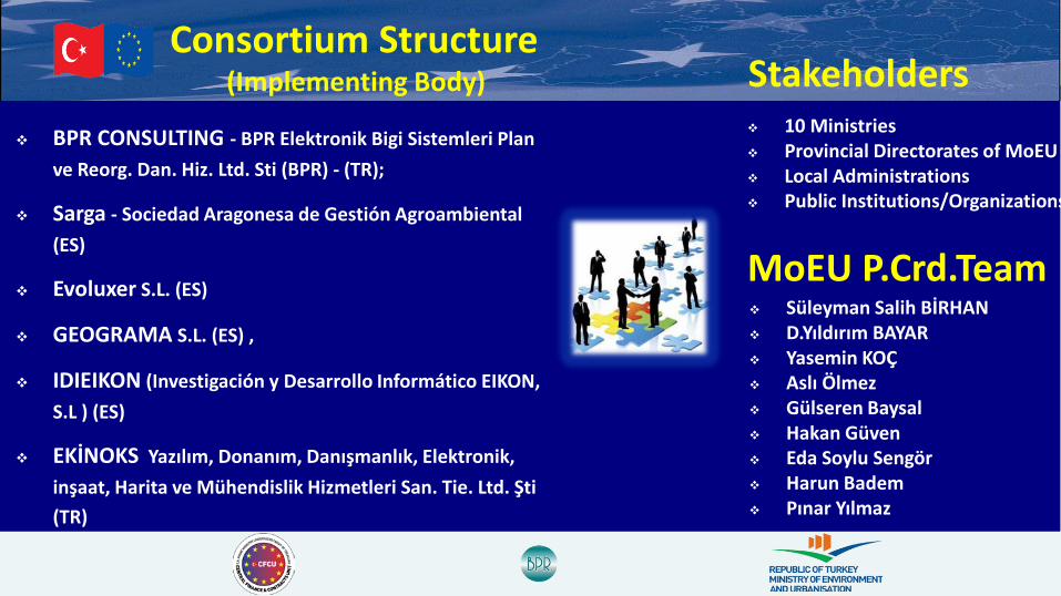
Consortium Structure(Implementing Body)
BPR CONSULTING - BPR Elektronik Bigi Sistemleri Plan ve Reorg. Dan. Hiz. Ltd. Sti (BPR) - (TR);
Sarga - Sociedad Aragonesa de Gestión Agroambiental(ES)
Evoluxer S.L. (ES)
GEOGRAMA S.L. (ES) ,
IDIEIKON (Investigación y Desarrollo Informático EIKON, S.L ) (ES)
EKİNOKS Yazılım, Donanım, Danışmanlık, Elektronik, inşaat, Harita ve Mühendislik Hizmetleri San. Tie. Ltd. Şti(TR)
MoEU P.Crd.Team Süleyman Salih BİRHAN D.Yıldırım BAYAR Yasemin KOÇ Aslı Ölmez Gülseren Baysal Hakan Güven Eda Soylu Sengör Harun Badem Pınar Yılmaz
10 Ministries Provincial Directorates of MoEU Local Administrations Public Institutions/Organizations
Stakeholders
This project is financed bythe European Union and the Republic of TurkeyThis project is co-financed by the European
Union and the Republic of Turkey.
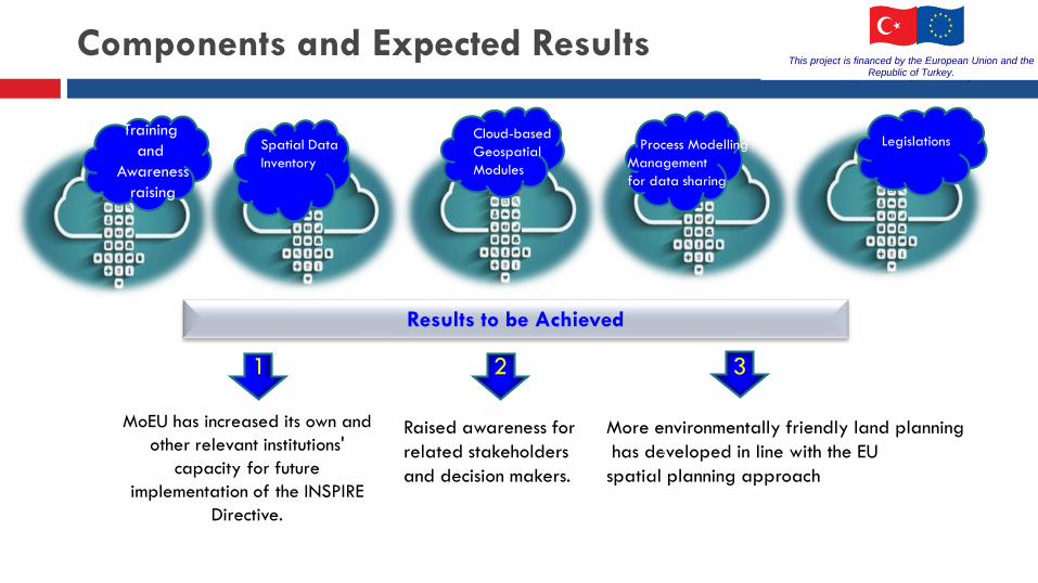
Components and Expected Results
Results to be Achieved
MoEU has increased its own and other relevant institutions'
capacity for futureimplementation of the INSPIRE
Directive.
Raised awareness for related stakeholders and decision makers.
More environmentally friendly land planninghas developed in line with the EUspatial planning approach
Cloud-basedGeospatial Modules
Training and
Awarenessraising
LegislationsProcess ModellingManagement for data sharing
O
TU
P
Spatial DataInventory
1 2 3
This project is financed by the European Union and the Republic of Turkey.

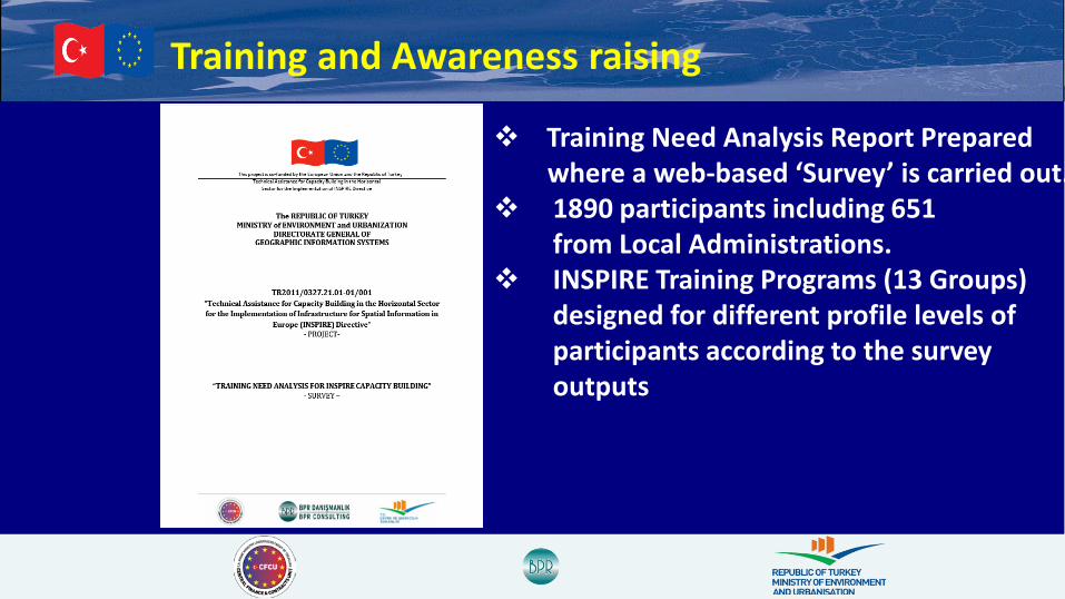
Training and Awareness raising
Activity-1 Know-how and experience for administrative and technical staff increased
Development of a Detailed Work Program and Revision of Project Time Schedule
Conducting TNA and Development of TNA ReportDevelopment of Training Program and Training Materials
Organization and Delivery of Trainings, Workshops, Seminars and INSPIRE ConferenceAttendances
Activity-2 Awareness for related major groups and decision makers raised
Organization of Seminars for Wider Audience
Organization of Study Visits
System Analysis and Design of the Training Portal
Implementation of the Training Portal
Development of an Internet Website for the Project
Training and Awareness raising
Training Need Analysis Report Preparedwhere a web-based ‘Survey’ is carried out.
1890 participants including 651 from Local Administrations.
INSPIRE Training Programs (13 Groups)designed for different profile levels of participants according to the surveyoutputs
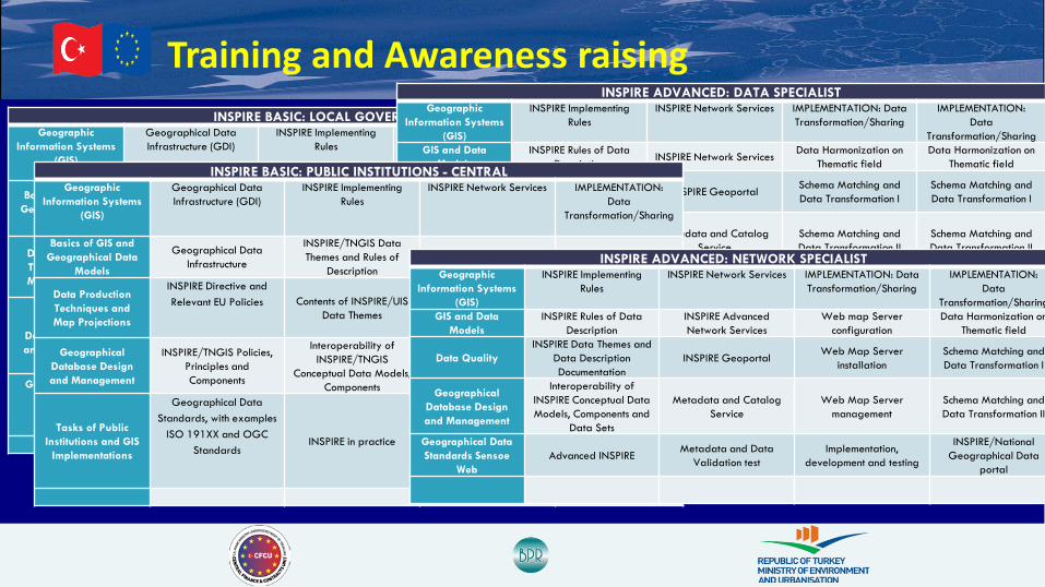
Training and Awareness raisingINSPIRE BASIC: LOCAL GOVERNMENTS
Geographic Information Systems
(GIS)
Geographical Data Infrastructure (GDI)
INSPIRE Implementing Rules
INSPIRE Network Services IMPLEMENTATION: Data
Transformation/Sharing
Basics of GIS and Geographical Data
Models
Geographical Data Infrastructure
Geographical Data Standards, with examples
ISO 191XX and OGC Standards
Metadata Data Harmonization
Data Production Techniques and Map Projections
INSPIRE Directive and Relevant EU Policies
INSPIRE/UIS Data themes and Data Description
DocumentationNetwork Services Schema Matching and
Data Transformation I
Geographical Database Design and Management
TNGIS/UIS Policies, Components and Data
Themes
Interoperability of INSPIRE/UIS Conceptual
Data Models, Components
Geographic Data Portal Schema Matching and Data Transformation II
Geographic Data Analysis and Presentation Techniques
UIS Implementations and Smart Cities
INSPIRE in practice Cloud UIS and Implementations
Using INSPIRE/National Geographical Data
Portal
INSPIRE ADVANCED: DATA SPECIALISTGeographic
Information Systems (GIS)
INSPIRE Implementing Rules
INSPIRE Network Services IMPLEMENTATION: Data Transformation/Sharing
IMPLEMENTATION: Data
Transformation/SharingGIS and Data
ModelsINSPIRE Rules of Data
Description INSPIRE Network Services Data Harmonization on Thematic field
Data Harmonization on Thematic field
Geographical Database Design and Management
NSPIRE Data Themes and Data Description Documentation
INSPIRE Geoportal Schema Matching and Data Transformation I
Schema Matching and Data Transformation I
Geographical Data Standards Sensoe
Web
Interoperability of INSPIRE Conceptual Data Models, Components and
Data Sets
Metadata and Catalog Service
Schema Matching and Data Transformation II
Schema Matching and Data Transformation II
Tasks of Public Institutions and GIS
ImplementationsLinked data Approach Metadata and Data
Validation test Cloud GIS platformINSPIRE/National
Geographical Data portal
INSPIRE BASIC: PUBLIC INSTITUTIONS - CENTRALGeographic
Information Systems (GIS)
Geographical Data Infrastructure (GDI)
INSPIRE Implementing Rules
INSPIRE Network Services IMPLEMENTATION: Data
Transformation/Sharing
Basics of GIS and Geographical Data
Models
Geographical Data Infrastructure
INSPIRE/TNGIS Data Themes and Rules of
DescriptionMetadata Data Harmonization
Data Production Techniques and Map Projections
INSPIRE Directive and Relevant EU Policies Contents of INSPIRE/UIS
Data Themes Network Services Schema Matching and Data Transformation I
Geographical Database Design and Management
INSPIRE/TNGIS Policies, Principles and Components
Interoperability of INSPIRE/TNGIS
Conceptual Data Models, Components
Geographic Data Portal Schema Matching and Data Transformation II
Tasks of Public Institutions and GIS
Implementations
Geographical Data Standards, with examples
ISO 191XX and OGC Standards
INSPIRE in practice E-government GIS Implementations
Using INSPIRE/National Geographical Data
Portal
INSPIRE ADVANCED: NETWORK SPECIALISTGeographic
Information Systems (GIS)
INSPIRE Implementing Rules
INSPIRE Network Services IMPLEMENTATION: Data Transformation/Sharing
IMPLEMENTATION: Data
Transformation/SharingGIS and Data
ModelsINSPIRE Rules of Data
DescriptionINSPIRE Advanced Network Services
Web map Server configuration
Data Harmonization on Thematic field
Data QualityINSPIRE Data Themes and
Data Description Documentation
INSPIRE Geoportal Web Map Server installation
Schema Matching and Data Transformation I
Geographical Database Design and Management
Interoperability of INSPIRE Conceptual Data Models, Components and
Data Sets
Metadata and Catalog Service
Web Map Server management
Schema Matching and Data Transformation II
Geographical Data Standards Sensoe
WebAdvanced INSPIRE Metadata and Data
Validation testImplementation,
development and testing
INSPIRE/National Geographical Data
portal

Training and Awareness raising 4 Seminars (Professionals and Stakeholders);
OGC Overview, OGC StandardsINSPIRE Overview, OGC StandardsBest NSDI-Focused Practices and INSPIRE RelationsDeveloping 3D City Models with CityGMLUse of INSPIRE Implementation Schemas for Data HarmonizationBest Practices for INSPIRE Data HarmonizationNational Spatial Data Infrastructure (‘SDI’) Implementations in TurkeyCapacity Building for Spatial Data Infrastructure
2 Technical Study Visits Spain and Italy
2 Work-shops 2 INSPIRE Conference Participation

Training and Awareness raising
1%
68%
31%
SEMINAR SESSIONS WERE RELEVANT TO NEEDS
NOT AT ALL WELL VERY WELL
1%35%
64%
SEMINAR ENHANCED MY AWARENESS in OGC,INSPIRE and
SDI ACTIVITIES.
NOT AT ALL WELL VERY WELL

Pilot Areas for Spatial Data Inventory
Kayseri Met.Muncp.Elazığ.Muncp.
Muğla Met. Muncp.
Pendik Muncp.

Data Assessment in Pilot Areas
Almost each municipality has data sets that correspond to data themes such as administrative unit, address, cadaster parcel, transportation, topography, reference systems, protected sites, transportation networks, buildings and land use as internal parts of their local GIS/UIS projects.
In this context, it is possible to produce and transform the data sets to INSPIRE standard at levels to fulfill basic and compulsory types of details and attributes.
Local Government
Data Availability
INSPIRE
Digital/AnalogCompatible
DataTransformable
Data
Kayseri Metropolitan Municipality and Talas Sub-Provincial Municipality
55 % 7 % 48 %
İstanbul- Pendik Sub-Provincial Municipality
59 % 9 % 50%
Elazığ Municipality 45 % 4% 41%
Muğla Metropolitan Municipality 49 % 5% 44%

Data Assessment in Pilot Areas
Compatibility of data sets, both on analog or digital media, held by each pilot local government with INSPIRE data themes and their percentage of availability are defined and graphically demonstrated as per the following criteria:
• INSPIRE-compatible• Available/ INSPIRE transformable• Available at other institutions/INSPIRE transformable• Need to be produced

Data Assessment in Pilot Areas
Need to be produced
Available in otherinstitutions/INSPIRE-transformable
Available/INSPIRE transformable
INSPIRE-compatible
Pendik Municipality APPENDIX I-II

Data Assessment in Pilot Areas
Pendik Municipality APPENDIX III
Need to be produced
Available in other institutions/INSPIRE-transformable
Available/INSPIRE transformable
INSPIRE-compatible
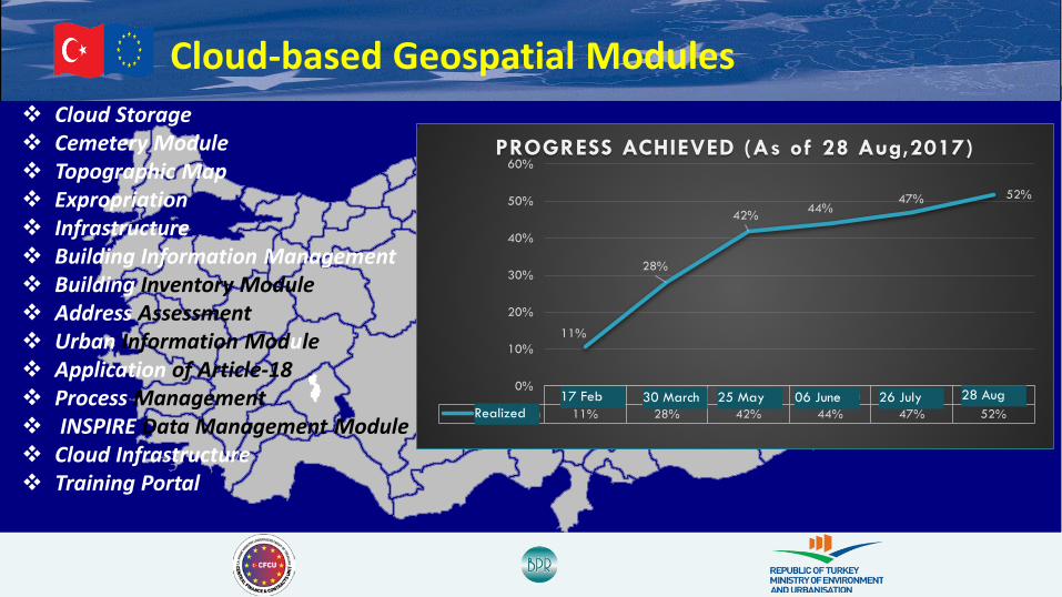
Cloud-based Geospatial Modules Cloud Storage Cemetery Module Topographic Map Expropriation Infrastructure Building Information Management Building Inventory Module Address Assessment Urban Information Module Application of Article-18 Process Management INSPIRE Data Management Module Cloud Infrastructure Training Portal
17 Şubat 30 Mart 25 Mayıs 06 Haziran 26 Temmuz 28 AğustosGerçekleşen 11% 28% 42% 44% 47% 52%
11%
28%
42% 44%47% 52%
0%
10%
20%
30%
40%
50%
60%PROGRESS ACHIEVED (As of 28 Aug,2017)
Realized28 Aug26 July06 June25 May30 March17 Feb

Cloud-based Geospatial Modules
Building Information Management 3D Topographic Map

Cloud-based Geospatial Modules Application of Article-18 Address Assessment

Cloud-based Geospatial Modules Cemetery Module Address Assessment

Cloud-based Geospatial Modules Infrastructure Cloud Storage

Process Modelling & Management Objective:
Provide a common process managementenvironment by constructing “To-Be” processmodels for Local Governments and puttingthese models into service via ProcessModelling and Management Softwarerunning on cloud platform in order tostandardize process flows of institutions,enable scalability and process optimization.
Target Stakeholders: Local Governments Provincial Directorates of MoEU 12 Government Institutions
Stages of Implementation: “As-Is” and “GAP” Analysis – At 4 Pilot Local Governments Business Areas – 6 Major Business Areas Covered “To-Be” Process Modelling – Optimized and Refined Process
Flows Cloud-Based Process Modelling and Management Software Synchronization – Between Process Modelling and Management
Software & Business Application Software Systems Deployment – Putting Process Models into Service Scale – Measure Performance and Improve Models
Target Outcomes: Upskill institutions in process improvement Provide a common ground for producing standard geographical and administrative data Enable institutions to design and execute their own process models.

Process Modelling & Management BPM Notation
Activiti – Open Source Business Process Management Platform
Staff Task Assignment
Execution of Processes
Model Pools
Integration with Application Software Modules

Legislations; INSPIRE Impact Analysis
Draft Regulatıon Memorandom of Understanding
AS-IS and GAP Analysis
Initial Process Management Plan Updated Process Mamagement Plan
To-Be Process Model
Deployment of Processing Model
Organization Plan
Deployment of Process Modelling and Management Toolsets
Process Management System Requirements Document Preparation of Requirements (IT
Infrastructure, Software and Training) Document
Data Exchange Strategy
Implementation Plan and Methodology
-------------- Indirect Input -------------- Direct Input and Follow-up’s
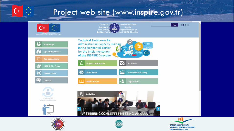
Project web site (www.inspire.gov.tr)

This project is financed bythe European Union and the
Republic of Turkey.
This publication has been developed with the financial assistance of the European Union.
The contents of this publication are the sole responsibility of BPR Consulting and can in no way be taken to reflect the views of the European Union.
Süleyman S. Birhan, ([email protected]) Department Director ,MoEU (On behalf of Beneficiary) Onur Lenk ([email protected]) Team Leader (On behalf of Consortium)