Anatomy, morphology, palynology and nutlet micromorphology ...
Pertanika 6(3), 61-89 (198.3)
Some T2 Terrace Soils of Peninsular Malaysia: I. Micromorphology,Genesis and Classification
J. SHAMSHUDDIN and E. TESSENSSoil Science Department, Faculty ofAgriculture,
Universiti Pertanian Malaysia, Serdang, Selangor, Malaysia.
Key words: T2 terrace soils; Peninsular Malaysia, micromorphology; genesis; classification
RINGKASAN
18 profil yang terdiri daripada 14 siri tanah teres Tz di Semenanjung Malaysia telah dikaji. Tanahtanah ini berasal daripada bahan aluvium campuran yang berumur Holosen. Kebanyakan tanah itu dikelaskan sebagai InseptisoL Yang lain-lainnya pula dikelaskan sebagai Entisol, Ultisol dan Alfisol. Kajianini menunjukkan tanah-tanah tersebut berada sama ada di peringkat luluhawa baharu atau pertengahan.Taburan pertalian k/h ialah gefurik di dalam famili berpasir, gefurik dan/atau kitonik di dalam familiberlom kasar, dan porpirik di dalam famili berlom halus dan berlempung. Adalah diketahui bahawa pitotislebih sering dijumpai di pantai timur daripada di pantai berat.
SUMMARY
18 profiles belonging to 14 soil series of the T z terrace soils of Peninsular Malaysia were studied.The soils are derived from alluvial materials of mixed origin of Holocene age. They are mainly Inceptisols.Others are classified as Entisols, Ultisols and Alfisols. The study indicates that the soils are either in therecent or intermediate stage of weathering. The c/f related distribution is gefuric in the sandy families,gefuric and/or chitonic in the coarse loamy families, and porphyric in the fine loamy and the clayeyfamilies. It is found that phytoliths are more common in the east than in the west coast of the peninsula-
INTRODUCTION
About 40% of the land surface of PeninsularMalaysia is hilly or mountainous (Gopinanthanand Paramananthan, 1979). Most of the flat areasoccur in the alluvial plains, which are either marineor riverine in origin. Riverine alluvial depositsoccur at three levels, namely T 3, Tz and T1, whichare respectively referred to as high, intermediateand low terraces (Gopinanthan, 1968). Of particular interest are the soils on Tz terraces becauseof their spatial distribution.
The objective of this study is to provideinformation for a complete taxonomic classification of Tz terrace soils as well as to study theirgenesis and micromorphology.
MATERIALS AND METHODS
18 pedons belonging to 14 soil series wereselected for the study. These are the soils ofNangka (1, 9), Kampung Pusu (2), Bukit Tuku (3),Kerayong (4, 12), Cherang Hangus (5), SungaiBuloh (7, 8, 13), Lintang (6), Subang (10), Sagomana (11), Rasau (14), Napai (15), Chuping (17)
61
and Holyrood (18). The soils are named approximating as much as possible the definition proposedby the Department of Agriclliture (Paramananthan,1981).
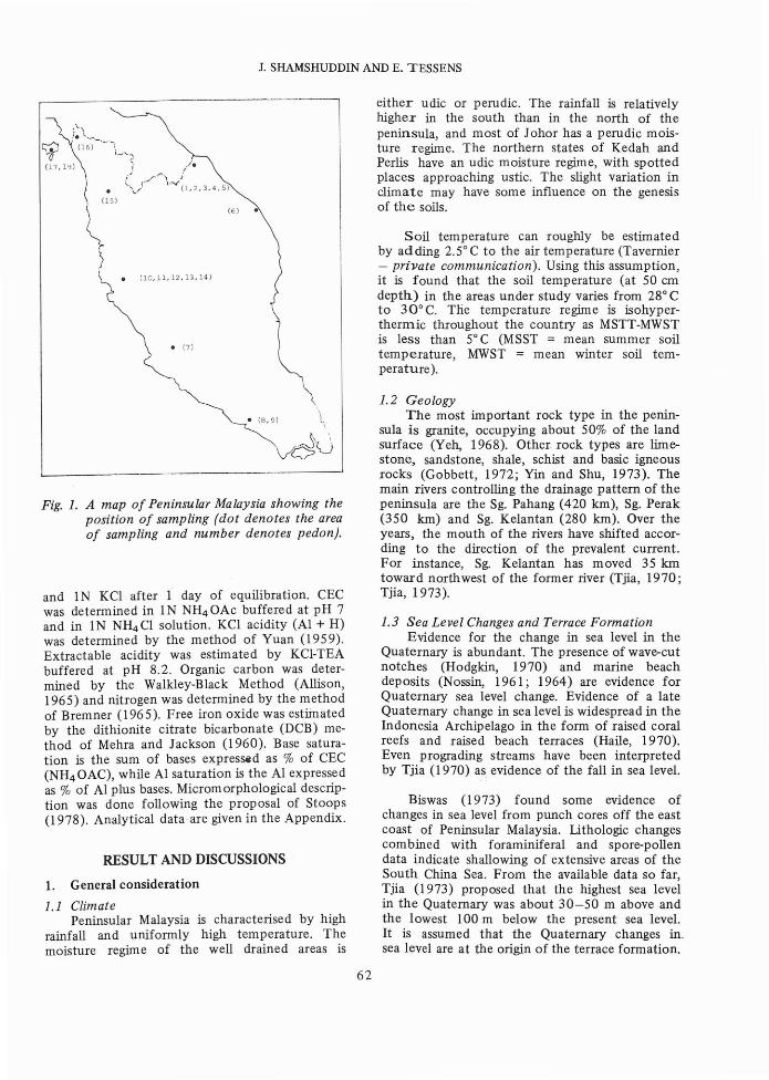
The soils were sampled from many areas(Fig. 1), where T2 terrace soils are known to befound. These are around the vicinity of Pasir Mas,Kelantan (1, 2, 3, 4, 5), Kuala Trengganu (6),Batu Pahat (8, 9), Sungai BUloh, Selangor' (7),Lower Perak (10, 11, 12, 13, 14), Pokok Sena,Kedah (15), Pauh, Perlis (16) and Langkawi (l7,18).
Types of samples taken are:-
1. Bulk samples for routine, physico-chemicaland mineralogical analyses.
2. Undistrubed samples in a Kubiena box formicromorphological analyses.
3. Core samples for physical analyses.
Analytical procedures are as follows: granulometric analysis was carried out by successivesedimentation. pH was determim'd both in water
1. SHAMSHUDDIN AND E. TESSENS
RESULT AND DISCUSSIONS
Fig. 1. A map of Peninsular Malaysia showing theposition of sampling (dot denotes the areaof sampling and number denotes pedon).
Biswas (1973) found some evidence ofchanges in sea level from punch cores off the eastcoast of Peninsular Malaysia. Lithologic changescombined with foraminiferal and spore-pollendata indicate shallowing of extensive areas of theSouth China Sea. From the available data so far,Tjia (1973) proposed that the highest sea levelin the Quaternary was about 30-50 m above andthe lowest 100 m below the present sea level.It is assumed that the Quaternary changes in.sea level are at the origin of the terrace formation.
1.3 Sea Level Changes and Terrace FormationEvidence for the change in sea level in the
Quaternary is abundant. The presence of wave-cutnotches (Hodgkin, 1970) and marine beachdeposits (Nossin, 1961; 1964) are evidence forQuaternary sea level change. Evidence of a lateQuaternary change in sea level is widespread in theIndonesia Archipelago in the form of raised coralreefs and raised beach terraces (Haile, 1970).Even prograding streams have been interpretedby Tjia (1970) as evidence of the fall in sea level.
1.2 GeologyThe most important rock type in the penin
sula is granite, occupying about 50% of the landsurface (Yeh, 1968). Other rock types are limestone, sandstone, shale, schist and basic igneousrocks (Gobbett, 1972; Yin and Shu, 1973). Themain rivers controlling the drainage pattern of thepeninsula are the Sg. Pahang (420 km), Sg. Perak(350 km) and Sg. Kelantan (280 km). Over theyears, the mouth of the rivers have shifted according to the direction of the prevalent current.For instance, Sg. Kelantan has moved 35 kmtoward northwest of the former river (Tjia, 1970;Tjia, 1973).
Soil temperature can roughly be estimatedby adding 2.5° C to the air temperature (Tavernier- private communication). Using this assumption,it is found that the soil temperature (at 50 emdepth) in the areas under study varies from 28° Cto 30° C. The temperature regime is isohyperthermic throughout the country as MSTT-MWSTis less than 5° C (MSST = mean summer soiltemperature, MWST = mean winter soil temperature).
either udic or perudic. The rainfall is relativelyhigher in the south than in the north of thepeninsula, and most of Johor has a perudic moisture regime. The northern states of Kedah andPerlis have an udic moisture regime, with spottedplaces approaching ustic. The slight variation inclimate may have some influence on the genesisof the soils.(6)
• (7)
//e
.- ) J\--v
(1,2,3,4,5)
(lo, 11, 12, 13, 14)
1. General consideration
1.1 ClimatePeninsular Malaysia is characterised by high
rainfall and uniformly high temperature. Themoisture regime of the well drained areas is
and 1N KCI after 1 day of equilibration. CECwas determined in 1N NH4 0Ac buffered at pH 7and in IN NH4 Cl solution. KCl acidity (AI + H)was determined by the method of Yuan (1959).Extractable acidity was estimated by KCl-TEAbuffered at pH 8.2. Organic carbon was determined by the Walkley-Black Method (Allison,1965) and nitrogen was determined by the methodof Bremner (1965). Free iron oxide was estiinatedby the dithionite citrate bicarbonate (DCB) method of Mehra and Jackson (1960). Base saturation is the sum of bases expres~d as % of CEC(NH4 0AC), while Al saturation is the Al expressedas % of Al plus bases. Microm orphological description was done following the proposal of Stoops(1978). Analytical data are given in the Appendix.
~ (16) -.,
(J(17,B)
~.\,. \'e ...._
62
SOME T2 TERRACE SOILS OF PENINSULAR MALAYSIA - I
1.4 Characteristics of Young AlluviumThe deposits fonning the T2 terraces are
unconsolidated deposits of sand and gravel withsome clay and peat. These deposits, which can beequated to Young Alluvium (Subrecent Alluvium),are of Holocene age «10,000 years). The YoungAlluvium is characterised by unweathered orslightly weathered clasts and soils developed fromit are commonly less than 2 m deep (Stauffer,1973). The Young Alluvium of the Kinta Valleycontains an abundant amount of sedimentarystructures of fluvial origin (Sivam, 1969). Sivam(1968) found the age of this deposit to be about3000 years.
2. Geographical DistributionPhysiographically, T 2 terrace soils are found
mainly at 20-30 m elevation, in areas adjacentto coastal plains, concentrated along major rivers.Up to this moment, over 25 soil series have beendefined and characterised by the Departmentof Agriculture (Paramananthan, 1980; 1981).
A quick look at the literature indicates thatthe 1flOSt common T2 terrace soils are apparentlySogomana, Nangka, Rasau, Holyrood, Lintang,Kerayong and Sungai Buloh Series, which arefound in the alluvial plains of Kelantan, Trengganu,Pahang and Perak (Leamy and Panton, 1965;
Law, 1968; Gopinathan, 1968). Soils of CherangHangus, Gong Chenak, Bukit Tuku and KampungPusu Series occur almost exclusively in KelantanPlains (Arnott, 1957; Law, 1968). Other soils suchas the soils of Chuping and Napai series are respectively found in Perlis and Kedah.
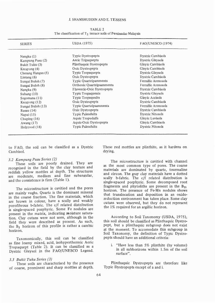
3. Characterisation of the soils (Table 1)
3.1 Nangka Series (1, 9)These soils are characterised in the field by a
loamy sand top soil underlain by sandy loam. Thestructures are weak, medium, subangular blockyand the consistence is friable.
The microstructure of this subsoil is cavitied,with channels and vughs as the main type of pores.The coarse materials are dominated by quartz.The fine materials, which are brown in colour,have undifferentiated b-fabric (1) or dotted scallyb-fabric (9). The undifferentiated b-fabric is theresult of coating by gibbsite (Stopps, 1978). Thec/f related distribution is chitonic and/or gefuric.Cavitied microstructure shows that the drainageis very good.
Physico-chemical and micromorphologicalstudies, and field observations indicate that thesoil is Typic Dystropept (Table 2). According
TABLE 1Field characteristics of T2 terrace soils of Peninsular Malaysia
(+ colour and texture at 50 cm depth).
SERIES COLOUR+ TEXTURE+ STRUCTURE CONSISTENCE DRAINAGE
Nangka (1) 10YR (6/4) sandy loam weak friable well drainedKampung Pusu (2) 2.5YR (7/3) clay loam moderate firm poorBukit Tuku (3) 2.5Y (6/4) clay loam moderate firm imperfectKerayong (4) 10YR (6/6) clay moderate firm moderateCherang Hangus (5) N7/ clay moderate plastic poorLintang (6) 10YR (5/6) sandy loam weak friable well drainedSungai Buloh (7) 10YR (5/4) coarse sand structureless loose excessiveSungai Buloh (8) 10YR (7/6) coarse loamy sand weak friable excessiveNangka (9) 10YR (6/4) coarse loamy sand moderate friable well drainedSubang (10) N7/ fine loamy sand structureless firm poorSogomana (11) N7/ silty clay loam weak firm poorKerayong (12) 10YR (5/4) clay loam moderate firm moderateSungai Buloh (13) 10YR (5/4) loamy coarse sand weak friable excessiveRasau (14) 2.5Y (8/3) loam moderate firm well drainedNapai (15) 5YR (5/8) sandy clay weak firm well drainedChuping (16) 10YR (6/6) clay loam weak friable imperfectAwang (17) 10YR (6/1) sandy clay loam weak firm imperfectHolyrood (18) 7.5YR (6/5) sandy clay loam weak friable well drained
63
1. SHAMSHUDDIN AND E. TESSENS
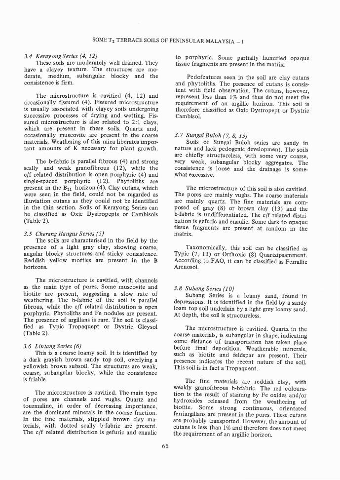
TABLE 2The classification of T2 terrace soils of Peninsular Malaysia
SERIES
Nangka (1)Kampung Pusu (2)Bukit Tuku (3)Kerayong (4)Cherang Hangus (5)Lintang (6)Sungai Buloh (7)Sungai Buloh (8)Nangka (9)Subang (10)Sogomana (11)Kerayong (12)Sungai Buloh (13)Rasau (14)Napai (15)Chuping (16)Awang (17)Holyrood (18)
USDA (1975)
Typic DystropeptsAerie TripaqueptsPlinthaquic DystropeptsOxic DystropeptsTypic TropaqueptsOxic DystropeptsTypic QuartzipammentsOrthoxic QuartzipsammentsFluventic-Oxic DystropeptsTypic TropaquentsTypic TropaquultsOxic DystropeptsTypic QuartzipsammentsOxic DystropeptsTypic PaleudultsAquic TropudalfsAquic-Oxic DystropeptsTypic Paleudults
FAO/UNESCO (1974)
Dystric CambisolsDystric GleysolsGleyic CambisolsGleyic CambisolsDystric GleysolsDystric CambisolsFerrallic ArenosolsFerrallic ArenosolsDystric CambisolsDystric GleysolsGleyic AcrisolsDystric CambisolsFerrallic ArenosolsDystric CambisolsDystric NitosolsGleyic LuvisolsGleyic CambisolsDystric Nitosols
to FAa, the soil can be classified as a DystricCambisol.
3.2 Kampung Pusu Series (2)These soils are poorly drained. They are
recognised in the field by the clay texture andreddish yellow mottles at depth. The structuresare moderate, medium and fine subangular,and the consistence is firm (Table 1).
The microstructure is cavitied and the poresare mainly vughs. Quartz is the dominant mineralin the coarse fraction. The fine materials, whichare brown in colour, have a scally and weaklyporofibrous lrfabric. The c/f related distributionis single-spaced porphyric. Some Fe nodules arepresent in the matrix, indicating llloisture saturation. Clay cutans were not seen, although in thefield they were described as present. As such,the B2 horizon of this profile is rather a cambichorizon.
Taxonomically, this soil can be classifiedas fine loamy mixed, acid, isohyperthermic AericTropaquept (Table 2). It can be classified as aDystric Gleysol in the FAa/UNESCO Legend.
3.3 Bukit Tuku Series (3)These soils are characterised by the presence
of coarse, prominent and sharp mottles at depth.
64
These red mottles are plinthite, as it hardens ondrying.
The microstructure is cavitied with channelas the most common type of pores. The coarsematerials are dominated by quartz, tourmalineand zircon. The gray clay materials have a dottedscally b-fabric. The c/f related distribution issingle-spaced porphyric. Some decomposed rootfragments and phytoliths are present in the B21horizon. The presence of Fe-Mn nodules showsthat translocation and deposition in an oxidoreduction environment has taken place. Some claycutans were observed, but they do not representthe 1% required for an argillic horizon.
According to Soil Taxonomy (USDA, 1975),this soil should be classified as Plinthaquic Dystropept, but a plinthaquic subgroup does not existat the moment. To accomodate this subgroup inSoil Taxonomy, the definition of Typic Dystropepts should have an additional criteria:
i. "Have less than 5% plinthite (by volume)in all subhorizons within 1.5m of the soilsurface".
Plinthaquic Dystropepts are therefore likeTypic Dystropepts except of a and i.
SOME T 2 TERRACE SOILS OF PENINSULAR MALAYSIA - I
3.4 Kerayong Series (4, 12)These soils are moderately well drained. They
have a clayey texture. The structures are moderate, medium, subangular blocky and theconsistence is firm.
The microstructure is cavitied (4, 12) andoccasionally fissured (4). Fissured microstructureis usually associated with clayey soils undergoingsuccessive processes of drying and wetting. Fissured microstructure is also related to 2: 1 clays,which are present in these soils. Quartz and,occasionally muscovite are present in the coarsematerials. Weathering of this mica liberates important amounts of K necessary for plant growth.
The b-fabric is parallel fibrous (4) and strongscally and weak granofibrous (12), while theclf related distribution is open porphyric (4) andsingle-spaced porphyric (12). Phytoliths arepresent in the B21 horizon (4). Clay cutans, whichwere seen in the field, could not be regarded asilluviation cutans as they could not be identifiedin the thin section. Soils of Kerayong Series canbe classified as Oxic Dystropepts or Cambisols(Table 2).
3.5 Cherang Hangus Series (5)The soils are characterised in the field by the
presence of a light gray clay, showing coarse,angular blocky structures and sticky consistence.Reddish yellow mottles are present in the Bhorizons.
The microstructure is cavitied, with channelsas the main type of pores. Some muscovite andbiotite are present, suggesting a slow rate ofweathering. The b-fabric of the soil is parallelfibrous, while the clf related distribution is openporphyric. Phytoliths and Fe nodules are present.The presence of argillans is rare. The soil is classified as Typic Tropaquept or Dystric Gleysol(Table 2).
3.6 Lin tang Series (6)This is a coarse loamy soil. It is identified by
a dark grayish brown sandy top soil, overlying ayellowish brown subsoil. The structures are weak,coarse, subangular blocky, while the consistenceis friable.
The microstructure is cavitied. The main typeof pores are channels and vughs. Quartz andtourmaline, in order of decreasing importance,are the dominant minerals in the coarse fraction.In the fine materials, stippled brown clay materials, with dotted scally b-fabric are present.The clf related distribution is gefuric and enaulic
65
to porphyric. Some partially humified opaquetissue fragments are present in the matrix.
Pedofeatures seen in the soil are clay cutansand phytoliths. The presence of cutans is consistent with field observation. The cutans, however,represent less than 1% and thus do not meet therequirement of an argillic horizon. This soil istherefore classified as Oxic Dystropept or DystricCambisol.
3.7 Sungai Buloh (7,8,13)Soils of Sungai Buloh series are sandy in
nature and lack pedogenic development. The soilsare chiefly structureless, with some very coarse,very weak, subangular blocky aggregates. Theconsistence is loose and the drainage is somewhat excessive.
The microstructure of this soil is also cavitied.The pores are mainly vughs. The coarse materialsare mainly quartz. The fine materials are composed of gray (8) or brown clay (13) and theb-fabric is undifferentiated. The clf related distribution is gefuric and enaulic. Some dark to opaquetissue fragments are present at random in thematrix.
Taxonomically, this soil can be classified asTypic (7, 13) or Orthoxic (8) Quartzipsamment.According to FAO, it can be classified as FerrallicArenosol.
3.8 SUbang Series (1 0)Subang Series is a loamy sand, found in
depressions. It is identified in the field by a sandyloam top soil underlain by a light grey loamy sand.At depth, the soil is structureless.
The microstructure is cavitied. QuartA in thecoarse materials, is subangular in shape, indicatingsome distance of transportation has taken placebefore final deposition. Weatherable minerals,such as biotite and feldspar are present. Theirpresence indicates the recent nature of the soil.This soil is in fact a Tropaquent.
The fine materials are reddish clay, withweakly granofibrous b-bfabric. The red colouration is the result of staining by Fe oxides andlorhydroxides released from the weathering ofbiotite. Some strong continuous, orientatedferriargillans are present in the pores. These cutansare probably transported. However, the amount ofcutans is less than 1%and therefore does not meetthe requirement of an argillic horizon.
J. SHAMSHUDDIN AND E. TESSENS
3.9 Sogomana Series (11)This soils is clayey. A lower clay content
in the surface horizon is compensated by a veryhigh silt content. Detailed investigation of thetextural profile suggests the presence of lithologicdiscontinuities throughout the profile.
The soil has a cavitied and fissured, and occasionally, irregular jointed microstructure at depth.The pores are mainly vughs. The coarse materialsare composed of quartz and muscovite, while thefine materials consist of dotted, yellowish grayclay materials. The b-fabric is dotted scally andvery broad and thin cross fibrous. The clf relateddistribution is open porphyric.
Irregular soil nodules (2-3 mm 1», which arecomposed of small nodules « I 00 urn) in different stages of formation, are present in the B21 t.Yellowish brown ferriargillans, with strong,continuous orientation, are present in the pores.The presence of thin patchy cutans, which wereobserved in the field, are therefore confirmed. Thisis a clear indication of clay translocation in theprofile. Field observations and laboratory analysesshow that the soil is a Typic Tropaquult or GleyicGleysol.
3.10 Rasau Series (14)The soil is recognised in the field by its loamy
texture and pale colour at depth. The structuresare moderate, medium and fine subangular block;and the consistence is friable.
The microstructure is also cavitied. Channelis the main type of pore. In the coarse materials,quartz, zircon and tourmaline are present. Thefine materials consist of dusty grey clay, withundifferentiated b-fabric. The clf related distribution is gefuric to close porphyric. The soil can beclassified as Oxic Dystropept.
3.11 Napai Series (15)Soils of Napai Series are ct.eveloped on re
worked lateritic materials from shale. Petroplinthite is present in the form of loose penetrableconcretions, usually at shallow depth. The structure of the top soil is weak to moderate, medium,subangular blocky. Thin patchy cutans were seenin the field. The study shows that the soil is amember of coarse loamy over clayey-skeletal,kaolinitic, isohyperthermic Typic Paleudults.
3.12 Chuping Series (16)This soil is developed on reworked lateritic
materials, resting on limestone of Chuping Formation. The top soil is a light yellowish brown sandy
66
loam overlying and brownish yellow sandy clayloam.
Thin patchy cutans characterise the B horizons. Distinct, brownish yellow mottles appearin the B21t . Petroplinthite sometimes appear atshallow depth. Base saturation is high, being 100%at depth. This soil is therefore classified as coarseloamy over fine loamy-skeletal, mixed, isohyperthermic, Aquic Tropudalf or Gleyic Luvisol.
3.13 A wang Series (1 7)This soil is derived from parent material
originated from tourmaline rich granite. The topsoil is a light gray coarse sand. This is underlainby a light brownish gray loamy sand. The colourbecomes lighter - wi.th depth. Yellowish brownmottles appear in B22 showing that the drainageconditions are somewhat impeded. This soil can beclassified as Aquic-Oxic Dystropept. A thin sectionfor this soil is not available.
3.14 Holyrood Series (18)Thin continuous cutans characterise the B2
horizon. The top soil is brown sandy clay loam,overlying a light brown sandy clay loam. Thecolour becomes redder with depth, due to theincrease of Fe oxides with depth. On availabledata, this soil can be classified as Typic Paleudult.A thin section for this soil is not available. Thus itis not possible to prove the presence of cutansmicromorphologically. There is an increase of claycontent with depth. -The presence of cutans andthe increase of clay with depth seems to indicatethat the soil is a Paleudult.
4. Genesis of T2 Terrace Soils
4.1 Influence ofSoil Forming FactorsIt is apparent that the most important factors
affecting the soil forming processes of T2 terracesoils are parent material and climate. 'It is knownthat the most important rock unit in the countryis granite, occupying about 50% of the total landsurface (Yeh, 1968). These granite bodies formmountain ranges in the central and the eastern partof the peninsula.
The chief rivers, which control the drainagepattern of the peninsula, originate and draw theirwater from those mountains. On their way to thesea, the rivers cut through other rock types andcarry along with them deposits of varying composition. The nature of the deposits vary fromclayey and silty to sandy materials. There isevidence to suggest that the textutal and themineralogical composition of the alluvial depositsare, for an important part, influenced by thegranite mineralogy. The dominance of subangular
SOME T 2 TERRACE SOILS OF PENINSULAR MALAYSIA - I
tourmaline in the heavy mineral fraction of theVFS (Pettijohn, 1957) further justifies the abovestatement.
However, some of the soils on T2 terraceare silty and clayey. These sediments are p'robab1ynot derived solely from granite. THere are twopossibilities with regard to the origin of the parentmaterials of these silty clayey soils:
1. The parent material is originated fromshale, phyllite, schist or other fine grainedsedimentary or metamorphic rock.
2. The parent materials are deposited in a lowenergy environment, characterised by finesediments (Reineck and Singh, 1973).
The mouths of rivers in Peninsular Malaysiashift according to the direction of the prevalentlong shore currents. The rivers in Kelantan andTrengganu move northwards, while the rivers inKedah and Perlis move southwards (Tjia, 1973).The change in the course of these rivers maychange the composition of the deposits of the areabecause it influences the environment of deposition. This may be at the origin of lithologicdiscontinuities and stratification of the sediments(see 5.1).
Coupled with parent material, climate andtime control the type and stage of weathering.Physico-chemical weathering of the deposits takesplace immediately after they are exposed to theatmosphere. With an annual rainfall exceeding2,000 mm in most parts of the country and amean annual temperature of about 27° C (Dale,1963), chemical weathering is intensive.
Topography and vegetation are playing amodifying role in this process of ferrallitic weathering. In the well drained areas, with importantremoval of silica and bases, weatherable mineralsare being transformed into kaolinite and/orsesquioxides, and in some cases, the soils arepractically devoid of weatherable minerals. On theother hand, where the drainage is impeded, feldspar, muscovite and even biotite survive secondarytransformation. The best example of the latter isthe Subang Series (l0).
4.2 FerrallitizationFerralitization is the chief soil forming process
in the humid tropics (Sys, 1979). This process ischaracterized by the dominance of 1: 1 claymineral and/or sesquioxides, particularly gibbsite.As evidenced byXRD and thermal analyses (Shamshuddin and Tessens, unpublished the studiedsoils have those minerals in the clay fraction.
67
Leaching and subsequently weathering issomewhat related to the textural compositionof the original alluvial deposits. Thus in sandymaterials, leaching and weathering are so intensethat primary minerals or even kaolinite maytransform to gibbsite. Such transformation Jsnoted in the soils of the Sungai Buloh Series (7),where gibbsite exceeds kaolinite in the clayfraction. On the contrary, in the loamy and theclayey materials, where leaching and weatheringare expected to be less intense, kaolinite dominates over gibbsite.
4.3 Clay TranslocationIn most cases, cutans were not seen in the thin
sections. The ones which contain cutans can notbe considered as having argillic horizons as the% of cutans is less than 1%. As such, it is considered that no major translocation of clay hasoccurred yet. In general, the soils contain a cambichorizon.
4.4 Weathering StageWeathering stage of soils can be defined by
various criteria. Among the criteria used are thesilt/clay ratio (Van Wambeke, 1962) and mineralogy of the clay fraction (Jackson and Sherman,1953). Stag~ of weathering can also be definedby the proposal of Sys (1979) or by the chargecharacteristics of the soils (Tessens and Shamshuddin, 1982).
In spite of the limitation, due to the problemof changing lithology, silt/clay ratio can be usedsuccessfully to obtain the stage of weatheringof the studied soils, as follows:-
1. Recent stage - silt/clay ratio is more than1.
2. Intermediate stage - silt/clay ratio is1-0.2.
3. Advanced stage - silt/clay ratio is lessthan 0.2.
The studied soils can be grouped accordingly(Table 3).
It is seen that most of the soils are either inthe recent or in the intermediate stage of weathering. The soils of Subang Series (10) give thehighest value (3.68), implying that they are theleast weathered soils. Thin-section study indicatedthat the soil contains feldspar, muscovite andbiotite, consistent with the high silt/clay ratio.On the other hand, the most weathered of the soilsare the Napai (15) and the Holyrood Series (18);these soils are Paleudults.
1. SHAMSHUDDIN AND E. TESSENS
TABLE 3Stage of weathering of T2 terrace soils
according to silt/clay ratio
TABLE 4Stages of ferrallitic weathering
RECENT INTERMEDIATERECENT INTERMEDIARY
5.1 Lithologic DiscontinuitiesIn the Kerayong Series (4), there appears to
be an increase. of clay in the B2 ; the increase of
In all systems, it is supposed that the soilchanges its properties on changing from recent toan advanced stage of weathering. This has adirect effect on the mineralogy and chemistryof the soil.
According to the stages of ferrallitic weatheringof Sys (1979), soils of Subang (10) and AwangSeries (1 7), which contain weatherable minerals,are in the recent stage (Table 4). Soils of SungaiBuloh Series (7, 8, 13) are difficult to put into thesystem, as they have no pedogenic developmentand dominated by kaolinite and/or gibbsite.Taxonomically, they are classified as Entisols.In this study, the soils are included in the recentstage of ferrallitic weathering. ()ther soils, withcambic or argillic horizons, are included in theintermediary stage.
Feldspar and biotite are minerals in the recentstage of weathering (Jackson and Sherman 1953).Muscovite, vermiculite and montmorillonite areminerals in the intermediate stage while kaoliniteand sesquioxides are minerals in the advancedstage of weathering. Based on this consideration,it is found that the soils of Subang (10) andAwang Series (17) fall under recent stage ofweathering; these soils contain biotite and feldspar. Soils in the intermediate stage of weatheringare the Nangka (1), Kampung Pusu (2), BukitTuku (3), Kerayong (4,12), Cherang Hangus (15),Sogomana (11), Napai (15), Chuping (16) andHolyrood Series (18). Soils of Lintang (6) andSungai Buloh Series (7, 8, 13) seem to fit into theadvanced stage of weathering.
Nangka (1,9)
Kampung Pusu (2)
Bukit Tuku (3)
Kerayong (4)
Cherang Hangus (5)
Lintang (6)
Sogomana (11)
Rasau (14)
Napai (15)
Chuping (16)
Holyrooq (18)
Sungai Buloh (7,8,13)
Subang (10)
Awang (17)
5.2 Micromorphology
5.2.1 Microstructure
It is noted for the soils in the sandy andcoarse loamy family that the microstructure iscavitied. This is well illustrated by the soils ofSungai Buloh (8, 13), Lintang (6) and NangkaSeries (1, 9). Likewise, the fine loamy family has acavitied microstructure. Cavitied and occasionallyfissured microstructures are found in the clayeysoils. Such is the case for the soils of KampungPusu (2), Kerayong (4, 12), Cherang Hangus (5)and Sogomana Series (11).
clay from Ap is 6.3%. This definitely does notmeet the requirement of an argillic horizon. Anargillic horizon needs at least an increase of 8%for this clayey soil (USDA, 1975). The texturaldifferentiation in the profile then is rather due toa change in the environment of sedimentation.This is expressed in the VFS/sand %. A change ofVFS/sand % from 34.6% over 50.4%. to 68.2%(Ap , B21 and B22 resp.) is an indication of thepresence of several lithologic discontinuitiesthroughout the profile.
Similarly, the VFS/sand % can be used toconfirm the presence of lithologic discontinuitiesin the soils of Cherang Hangus (5), Subang (10),Sogomana (11), Kerayong (15) and Awang Series(17). Such discontinuities were not recognizedin the field.
Lintang (6)
Nangka (9)
Napai (15)
Holyrood (18)
Kg. Pusu (2)
Keryong (4)
Chg. Hangus (5)
Chuping (16)
Awang (17)
GENERAL DISCUSSION
Nangka (1)
Bt. Tuku (3)
Subang (10)
Sogomana (11)
Kerayong (12)
Rasau (14)
5.
68
SOME T2 TERRACE SOILS OF PENINSULAR MALAYSIA - I
Microstructure is related to the porosity ofthe soil. Cavitied microstructure is usually associated with high porosity, meaning that watercan pass through easily.
5.2.2 Coarse Materials (> 10 um)
Regardless of texture, the most commonmineral in the coarse materials, in these soils,is quartz. These quartz grains vary in size fromcoarse to fine, with a subangular to angular shape.Roundness of the grains will, to a certain extent,provide information on the distance of transportation before final deposition takes place, as grainswhich have undergone a long distance of transportation are usually rounded.
Other minerals in the coarse materials arezircon and tourmaline. According to Pettijohn(1957), rounded tournaline and zircon originatefrom reworked sediments, while euhedral tourmaline and zircon originate from acid igneous rock.Most of the tourmaline and zircon in the studiedsoils are subangular in shape. This is an indicationthat the soil material is influenced by acid igneousrocks, transported over some distance.
5.2.3 Fine materials « 10 um)
The fine materials consist of clay minerals,varying in colour from ,grey to red. From themineralogical studies, it is found that these materials are mainly kaolinite, 2: 1 minerals andmixed layers. Beside these, there is also an important amount of gibbsite, especially in the sandysoils. The gibbsite coatings affect the b-fabric ofthe fine materials.
The undifferentiated b-fabric seen in thesandy soils is probably the result of gibbsitecoating andlor masking of this sesquioxidicmaterials on the clay surfaces (Stoops, 1978;Eswaran et aI, 1979). Under crossed polarizers,the fine materials are almost isotropic. Theb-fabric of the clayey soils is either scally orfibrous or both. This type of b-fabric is present inthe soils of Kampung Pusu (2), Kerayong (4)Cherang Hangus (5) and Sogomana Series (11).
5.2.4 C/F Related Distribution
The clf related distribution of T2 terracesoils depends for an important part on the texturalcomposition of the soils. In the sandy family,the clf related distribution are locally observedin these soils. This type of clf related distributionis noted for the soils of Sungai Buloh Series (8, 13).
As the amount of clay in the soils increases,the clf related distribution tends toward porphyric.
69
In the coarse loamy family, such as Nangka (1)and Lintang (6), the clf related distribution isgefuric andlor chitonic, tending toward porphyric.Soils of Bukit Tuku (3) and Rasau Series (14),which are fine loamy, have porphyric clf relateddistribution. Gefuric clf related distribution wasfound only occasionally in these soils. The clfrelated distribution of the clayey soils, such as theKampung Pusu (2), Kerayong (4, 12), CherangHangus (5) and Sogomana Series (11), is almostexclusively porphyric. Texture plays an importantrole in the formation of the name clf relateddistribution. It is the clays that bind togetherand coat the coarse materials.
Related to classification, gefuric is commonin Entisols. Among the gefuric, chitonic, enaulicand porphyric, the more developed profiles haveat least two of these clf types.
5.2.5 Clay Cutans
The consequence of physical translocation ofclay mineral in the soil is the formation of anargillic horizon. One of the conditions for theformation of this horizon is minimal soil pedoturbation, in order to prevent the assimilation ofthe argillans into the matrix (Eswaran et al.,1979). Formation of the argillans is a dispersion
deposition phenomenon (Eswaran and Sys, 1979).The subject of clay cutans is an important issuein this study, as clay cutans are an importantparameter in soil classification.
In the field, all the clayey soils and some ofthe loamy soils were described as having thinpatchy cutans. When these soils were examinedunder the microscope, clay cutans could not beidentified, except occasionally in the soils of BukitTuku (3) and Lintang Series (6); only the soilsof Sogomana Series (11) contain a sufficientamount of cutans. The soils of Kampung Pusu (2),Kerayong (4, 12) Cherang Hangus (5) and RasauSeries (14) do not show the presence of claycutans.
The problem of cutans identification has alsobeen discussed at length by Beinroth (1982)for soils of Puerto Rico. It was found that fieldobservation of clay skins and their distinctionfrom stress cutans is a serious difficulty in soilshaving clayey texture and kaolinitic mineralogy.For instance, an Oxic Tropohumult, which hasbeen described as having many clay skins in thefield, was found to contain only 2% cutans. On theother hand, another soil, which had been classifiedas Oxisol, contained 4% cutans. 'T'he unequivocalrecognition of an argillic horizon as defined in
1. SHAMSHUDDIN AND E. TESSENS
Soil Taxonomy poses serious problems in the soilsof the humid tropics.
5.2.6 Phytoliths
These are opaline silica and therefore areisotopic under crossed polarizers. Under polarizedlight, phytoliths have characteristics of rectangularplant cells, with a rather high negative relief(Stoops, 1978). The XRD pattern resembles thatof high temperature silica (crystobalite), with astrong reflection peak at 4A (Brown et al., 1978).This peak was seen many times in the XRDdiffractograms of the silt fraction. The soils thatcontain phytoliths are Lintang (6), Kerayong (4),Cherang Hangus (5) and Bukit Tuku Series (3). Allof these soils are from the east coast of PeninsularMalaysia. Soils on T2 terrace from the west coastappear to contain few or no phytoliths, as evidenced from the study of thin-sections.
CONCLUSIONSome T2 terrace soils are found in Peninsular
Malaysia. These soils are either in a recent orintermediate stage of weathering, shown by thesilt/clay ratio and mineralogy. Most of the soilscontain some cutans, but could not be regardedas illuviation cutans as the amount is less than 1%required for an argillic horizon. These soils aretherefore classified as Inceptisols. The sandy soilslack pedogenic development and are classifiedas Entisols. Others are either Ultisols or Alfisols.
The change of clay content with depth is dueto a change in the environment of sedimentationrather than clay illuviation. The presence oflithologic discontinuities in the profiles is shownby a change of the VFS/sand % ratio. The c/frelated distribution of sandy soils is gefuric,while those of coarse loamy is gefuric and/orchitonic. The fine loamy and clayey soils haveporphyric c/f related distribution. Phytoliths aremore common in the east than the west coast ofthe peninsula.
ACKNOWLEDGEMENTThe authors wish to record their gratitude to
Prof. C. Sys and Prof. G. Stoops of the StateUniversity of Ghent for supervising the research,and UPM and ABOS for financial support. Theyalso wish to thank Dr. Paramananthan for hishelp in the sampling.
REFERENCES
ALLISON, LE. (1965): Organic carbon by WalkleyBlack Method. In: "Methods of Soil Analysis".Black, c.A. (Ed.). Agronomy Monograph. 9: 13671378.
70
ARNOTT. G.W. (1957): The Kelantan deficiency area.Malays. Agric. J. 40: 60-91.
BEINROTH, F.H. (1982): Some highly weathered soilsof Puerto Rico, 1. Morphology, formation andclassification. Geoderma. 27: 1-73.
BISWAS, B. 1973): Quaternary changes in sea level inSouth China Sea. Bull. Geol. Soc. Malays. 6: 229256.
BREMNER, J.M. (1965): Total nitrogen. In: "Methodsof Soil Analysis". Black, C.A. (Ed.). AgronomyMonograph. 9: 1149-1178.
BROWN, G., NEWMAN, A.C.D., RAYNER, J.H. andWEIR, A.H. (1978): The structure and chemistry ofSoil Constituents". Greenland, D.J. and Hayes,M.H.B. (Eds.). New York. John Wiley and Sons.29-78.
DALE, W.L (1983): Surface temperature of Malaya.J. Trop. Geog. 17: 57-73.
ESWARAN, H. and SYS, C. (1979): Argillic horizon inLAC soils: formation and significance to classification. Pedologie. 2(2): 175-190.
ESWARAN, H. VAN WAMBEKE, A. and BEINROTH,F.H. (1979): A study of some highly weathered soilsof Puerto Rico: Micromorphological properties.Pedologie. 29(2): 139-162.
FAO/UNESCO (1974): Soil Map of the World. Vol. 1.Legend. UNESCO, Paris.
GOBBETT, D.J. (1972): Geological Map of the MalayPeninsula. Geol. Soc. Malays., Kuala Lumpur.
GOPINATHAN, B. (1968): Terrace and alluvial soils inWest Malaysia. Proc. 3rd Malaysian Soil Conference.Malaya. Soc. Soil Sci., Sarawak, pp. 45-50.
GOPINATHAN, B. and PARAMANANTHAN, S. (1979):Steepland soils in Peninsular Malaysia. Proc. Malaysian Seminar on Fertility and Management of Deforested Soils. Soc. Agric., Sci. Sabah and Malays.Soc. Soil Sci., pp. 61-68.
HAILE, N.S. (1970): Radiocarbon dates of Holoceneemergence and submergence in Tembelau andBunguran Islands, Sunda Shelf, Indonesia. Bull.GeoL Soc. Malays 3: 135-137.
HODGKIN, E.P. (1970): Geomorphology and biologicalerosion of limestone coast in Malaysia. Bull. Geol.Soc. Malays. 3: 27-51.
JACKSON, M.L and SHERMAN, G.D. (1953): Chemicalweathering of mineral soils. Adv. in Agron. 5:219-318.
LAW, W.M. (1968): Reconnaissance Soil Map of Peninsular Malaysia. Ministry of Agriculture and Cooperative, Kuala Lumpur.
LEAMY, M.L and PANTON, W.P. (1965): A Soil SurveyManual For Malayan Conditions. Soil ScienceDivision, Ministry of Agriculture and Cooperative,Kuala Lumpur.
MEHRA, O.P. and JACKSON, M.L. (1960): Iron oxideremoval from soils and clays by dithionite-citrate
SOME T2 TERRACE SOILS OF PENINSULAR MALAYSIA - I
system with sodium bicarbonate buffer. Clays andClay Minerals. 7: 317-327.
NOSSIN, J.J. (1961): Relief and coastal developmentin north-eastern Johore. J. Trop. Geog. 15: 27-39.
NOSSIN, J.1. (1964): Beach ridges in the east coast ofMalaya. J. Trop. Geog. 18: 111-117.
PARAMANANTHAN, S. (1980): Draft field legend forsoil survey in Pen~sular Malaysia. Soil ScienceDivision, Ministry of Agriculture and Rural Development, Kuala Lumpur.
PARAMANANTHAN, S. (1981): Simplified key to theidentification of Peninsular Malaysia (In press).
PETTIJOHN. F.J. (1957): Sedimentary Rocks. NewYork. Harper and Row Publication.
REINECK, H. and SINGH, LB. (1973): Depositionalsedimentary Environments. New York. SpringerVerlag.
SIVAM. S.P. (1968): Radiocarbon dates in Kinta Valley.Newsletter. Geol. Soc. Malays. 15(1).
SIVAM, S.P. (1969): Quaternary alluvial deposits inNorth Kinta Valley, Perak. M.Sc. thesis, U.M.,Kuala Lumpur.
STAUFFER, P.H. (1973): Cenozoic. In "Geology of theMalay Peninsular". Gobbett, D.J. and Hutchison, C.S.(Ed.). New York. John Wiley and Sons. pp. 143176.
71
STOOPS, G. (1978): Provisional notes on micropedology.lTC., Rug., Belgium.
SYS, C. (1979): Tropical soils. II. lTC., Rug., Belgium.
TESSENS. E. and SHAMSHUDDIN. 1. (1982): Characteristics related to charges in Oxisols of PeninsularMalaysia. Pedologie 32: 85-106.
TJIA, R.D. (1970): Monsoon-control of the easternshorelines of Malaya. Bull. Geol. Soc. Malays. 3:9-15.
TJIA, H.D. (1973): Geomorphology. In: Geology of theMalay Peninsula. Gobbett, D.J. and Hutchison, C.S.(Eds.). New York. John Wiley and Sons. pp. 13-24.
USDA (1975): Soil Taxonomy: A basic system of soilclassification for making and interpreting soil survey.USDA Handbook No. 436. Washington.
VAN WAMBEKE. A. (1962): Criteria for classifyingtropical soils by age. J. Soil Sci. 13: 124-132.
YEH. C.S.K. (1968): Regional geology: West Malaysia.Brief outline of the geology of West Malaysia.Malays. GeoL Surv. Rept. pp.53-67.
YIN. E.H. and SHU. Y.K. (1973): Geological Map ofPeninsular Malaysia. Geological Survey Malaysia.Ipoh.
YUAN, T.L. (1959): Determination of exchangeablehydrogen by titration method. Soil Sci. 88: 164167.
(Received 25 February 1983)
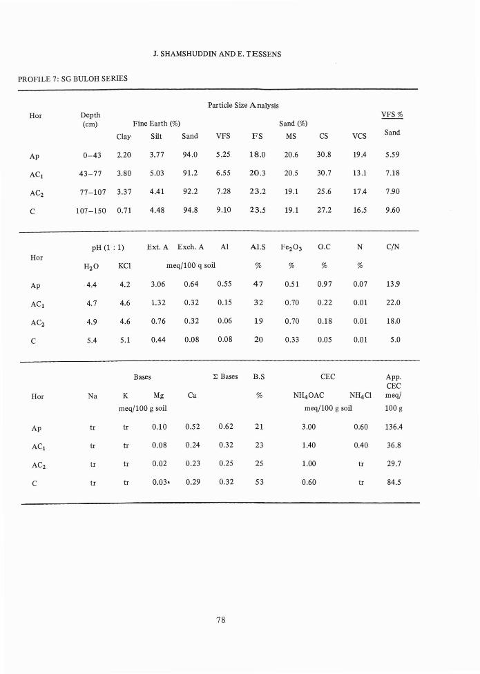
PROFILE 1: NANGKA SERIES
J. SHAMSHUDDIN AND E. TESSENS
APPENDIX
Hor
Ap
Particle Size AnalysisDepth(em) Fine Earth (%) Sand (%) VFS%
Clay Silt Sand VFS FS MS CS VCS Sand
0-25 8.50 8.50 83.0 4.73 28.3 27.5 13.9 8.32 5.70
25-69 9.20 12.8 78.0 4.60 23.6 27.8 15.7 6.20 5.23
69-125 12.1 10.5 77.4 4.78 23.6 27.1 15.2 6.44 6.18
pH (l : 1) Ext. A Exeh. A Al ALS Fe203 O.C N C/NHor
H2O KCI meq/l00 q soil % % % %
Ap 5.7 4.4 4.70 0.48 0.43 14 0.21 1.27 0.09 14.1
B21 6.0 4.2 2.88 0.24 0.14 8 0.29 0.24 0.05 4.8
B22 5.3 4.2 2.66 0.90 0.90 24 0.29 0.12 0.02 6.0
Bases 1: Bases B.S CEC App.CEC
Hor Na K Mg Ca % NH4 0AC NH4 CI meq/
meq/l00 g soil meq/100 g soil 100 g
A 0.08 0.06 0.17 2.36 2.67 48 5.60 2.90 65.9
B22 tr 0.02 0.11 1.41 1.54 43 3.60 1.80 39.1
B22 0.04 0.02 0.08 2.71 2.85 98 2.90 1.60 23.9
72
SOME T2 TERRACE SOILS OF PENINSULAR MALAYSIA - I
PROFILE 2: KG PUSU SERIES
HOI
Ap
Particle Size AnalysisDepth VFS%(em) Fine EaIth (%) Sand (%)
Clay Silt Sand VFS FS MS CS VCS Sand
0-21 35.4 25.3 39.3 10.8 19.3 5.70 2.89 0.59 27.5
21-46 37.9 21.6 40.5 11.4 18.8 6.54 2.93 0.74 28.1
46-100 29.4 20.3 50.3 14.2 24.2 7.40 3.14 1.38 28.2
pH (1 : 1) Ext. A Exeh. A Al Al.S Fe203 O.C N C/NHOI
H2O KCl meq/100 q soil % % % %
Ap 4.9 4.0 23.7 3.52 3.21 75 0.84 5.31 0.16 33.2
B21 5.0 3.8 18.0 2.96 2.85 85 0.97 0.18 0.05 3.6
B22 5.1 3.8 12.8 2.72 2.49 82 0.21 0.03 0.05 0.6
Bases :E Bases B.S CEC App.CEC
HOI Na K Mg Ca % NH4 0AC NH4 Cl meq/
meq/100 g soil meq/100 g soil 100 g
Ap 0.04 0.12 0.32 0.57 1.05 6 18.1 6.60 51.1
B21 tI 0.02 0.09 0.40 0.51 4 11.5 4.80 30.3
B22 0.04 0.02 0.09 0.38 0.53 4 12.2 5.40 41.5
73
J. SHAMSHUDDIN AND E. TESSENS
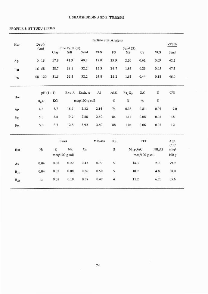
PROFILE 3: BT TUKU SERIES
Particle Size AnalysisHOI Depth VFS%
(em) Fine Earth (%) Sand (%)Clay Silt Sand VFS FS MS CS VCS Sand
Ap 0-16 17.9 41.9 40.2 17.0 19.9 2.60 0.61 0.09 42.3
B21 16-58 28.7 39.1 32.2 15.3 14.7 1.86 0.23 0.05 47.5
B22 58-130 31.5 36.3 32.2 14.8 15.2 1.63 0.44 0.18 46.0
pH (1 : 1) Ext. A Exeh. A Al Al.S Fe203 O.C N C/NHOI
H2O KCI meq/l00 q soil % % % %
Ap 4.8 3.7 16.7 2.32 2.14 74 0.36 0.81 0.09 9.0
B21 5.0 3.8 19.2 2.88 2.60 84 1.14 0.08 0.05 1.8
B22 5.0 3.7 12.8 3.92 3.60 88 1.04 0.06 0.05 1.2
Bases ~ Bases B.S CEC App.CEC
HOI Na K Mg Ca % NH40AC NH4CI meq/
meq/l00 g soil meq/l00 g soil 100 g
Ap 0.04 0.08 0.22 0.43 0.77 5 14.3 2.70 79.9
B21 0.04 0.02 0.08 0.36 0.50 5 10.9 4.80 38.0
B22 tl O.OZ 0.10 0.37 0.49 4 11.2 6.20 35.6
74
SOME T2 TERRACE SOILS OF PENINSULAR MALAYSIA - I
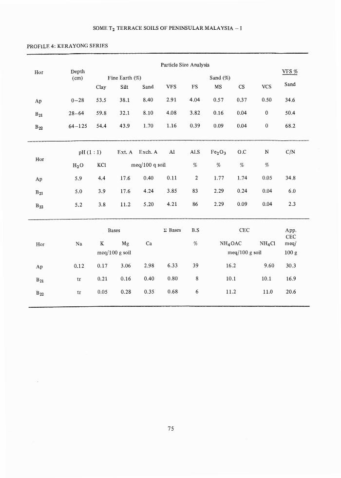
PROFiLE 4: KERAYONG SERIES
Hor
Ap
Particle Size AnalysisDepth VFS%(em) Fine Earth (%) Sand (%)
Clay Silt Sand VFS FS MS CS VCS Sand
0-28 53.5 38.1 8040 2.91 4.04 0.57 0.37 0.50 34.6
28-64 59.8 32.1 8.10 4.08 3.82 0.16 0.04 0 50.4
64-125 54.4 43.9 1.70 1.16 0.39 0.09 0.04 0 68.2
pH(l: 1) Ext. A Exeh. A Al A1.S Fe203 O.C N CjN
HorH2O KCI meq/100 q soil % % % %
Ap 5.9 4.4 17.6 0.40 0.11 2 1.77 1.74 0.05 34.8
B21 5.0 3.9 17.6 4.24 3.85 83 2.29 0.24 0.04 6.0
B22 5.2 3.8 11.2 5.20 4.21 86 2.29 0.09 0.04 2.3
Bases :E Bases B.S CEC App.CEC
Hor Na K Mg Ca % NH4 0AC NH4CI meqj
meqj100 g soil meqj100 g soil 100 g
Ap 0.12 0.17 3.06 2.98 6.33 39 16.2 9.60 30.3
B21 tr 0.21 0.16 0040 0.80 8 10.1 10.1 16.9
B22 tr 0.05 0.28 0.35 0.68 6 11.2 11.0 20.6
75
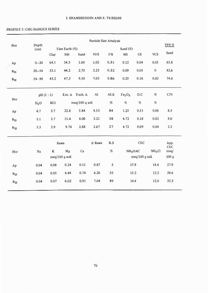
PROFILE 5: CHG HANGUS SERIES
J. SHAMSHUDDIN AND E. TESSENS
HOI
" Ap
B22
Particle Size AnalysisDepth ~(em) Fine Earth (%) Sand (%)
Clay Silt Sand VFS FS MS CS VCS Sand
0-20 64.1 34.3 1.60 1.02 0.31 0.12 0.04 0.05 63.8
20-54 53.1 44.2 2.70 2.23 0.32 0.09 0.05 0 82.6
54-90 43.2 47.3 9.50 7.03 0.86 0.20 0.16 0.82 74.0
pH (1 : 1) Ext. A Exeh. A Al Al.S Fe203 O.C N CjN
HOIH2O KCI meqj100 q soil % % % %
Ap 4.7 3.7 22.8 5.84 4.53 84 1.Z5 0.51 0.06 8.5
B21 5.1 3.7 11.4 4.00 3.21 38 4.72 0.18 0.02 9.0
B22 5.3 3.9 9.74 2.88 2.67 27 4.72 0.09 0.04 2.3
Bases :E Bases B.S CEC App.CEC
HOI Na K Mg Ca % NH40AC NH4 CI meqj
meqJ100 g soil meqj100 g soil 100 g
Ap 0.04 0.08 0.24 0.51 0.87 5 11.9 14.4 27.9
B21 0.04 0.05 4.44 0.74 6.26 35 15.2 13.2 28.6
B22 0.04 0.07 6.02 0.91 7.04 49 14.4 12.0 33.3
76
SOME T2 TERRACE SOILS OF PENINSULAR MALAYSIA - I
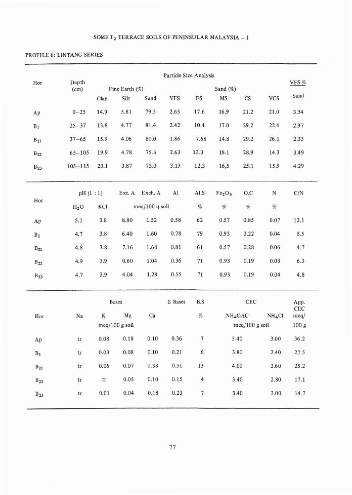
PROFILE 6: LINTANG SERIES
Particle Size AnalysisHOI Depth VFS%
(em) Fine Earth (%) Sand (%)
Clay Silt Sand VFS FS MS CS VCS Sand
Ap 0-25 14.9 5.81 79.3 2.65 17.6 16.9 21.2 21.0 3.34
B1 25-37 13.8 4.77 81.4 2.42 10.4 17.0 29.2 22.4 2.97
B21 37-65 15.9 4.06 80.0 1.86 7.68 14.8 29.2 26.1 2.33
B22 65-105 19.9 4.78 75.3 2.63 13.3 18.1 28.9 14.3 3.49
B23 105-115 23.1 3.87 73.0 3.13 12.3 16,5 25.1 15.9 4.29
pH (1 : 1) Ext. A Exeh. A Al Al.S Fe203 O.C N C/NHor
H2O KCl meqj100 q soil % % % %
Ap 5.1 3.8 8.80 1.52 0.58 62 0.57 0.85 0.07 12.1
Bl 4.7 3.8 6.40 1.60 0.78 79 0.93 0.22 0.04 5.5
B21 4.8 3.8 7.16 1.68 0.81 61 0.57 0.28 0.06 4.7
B22 4.9 3.9 0.60 1.04 0.36 71 0.93 0.19 0.03 6.3
B23 4.7 3.9 4.04 1.28 0.55 71 0.93 0.19 0.04 4.8
Bases :E Bases B.S CEC App.CEC
Hor Na K Mg Ca % NH40AC NH4Cl meq/
meq/100 g soil meqjlOO g soil 100 g
Ap tr 0.08 0.18 0.10 0.36 7 5.40 3.00 36.2
Bl tr 0.03 0.08 0.10 0.21 6 3.80 2.40 27.5
B21 tr 0.06 0.07 0.38 0.51 13 4.00 2.60 25.2
B22 tr tr 0.05 0.10 0.15 4 3.40 2.80 17.1
B23 tr 0.01 0.04 0.18 0.23 7 3.40 3.00 14.7
77
1. SHAMSHUDDIN AND E. TESSENS
PROFILE 7: SG BULOH SERIES
Particle Size AnalysisHor Depth VFS%
(em) Fine Earth (%) Sand (%)
Clay Silt Sand VFS FS MS CS VCS Sand
Ap 0-43 2.20 3.77 94.0 5.25 18.0 20.6 30.8 19.4 5.59
ACt 43-77 3.80 5.03 91.2 6.55 20.3 20.5 30.7 13.1 7.18
AC2 77-107 3.37 4.41 92.2 7.28 23.2 19.1 25.6 17.4 7.90
C 107-150 0.71 4.48 94.8 9.10 23.5 19.1 27.2 16.5 9.60
pH (1 : 1) Ext. A Exeh. A Al A1.S Fe203 O.C N C/NHor
H2O KCI meq/100 q soil % % % %
Ap 4.4 4.2 3.06 0.64 0.55 47 0.51 0.97 0.07 13.9
ACt 4.7 4.6 1.32 0.32 0.15 32 0.70 0.22 0.01 22.0
AC2 4.9 4.6 0.76 0.32 0.06 19 0.70 0.18 0.01 18.0
C 5.4 5.1 0.44 0.08 0.08 20 0.33 0.05 0.01 5.0
Bases ~ Bases B.S CEC App.CEC
Hor Na K Mg Ca % NH4 0AC NH4 CI meq/
meq/100 g soil meq/100 g soil 100 g
Ap tr tr 0.10 0.52 0.62 21 3.00 0.60 136.4
ACt tr tr 0.08 0.24 0.32 23 1.40 0.40 36.8
AC2 tr tr 0.02 0.23 0.25 25 1.00 tr 29.7
C tr tr 0.03· 0.29 0.32 53 0.60 tr 84.5
78
SOME T2 TERRACE SOILS OF PENINSULAR MALAYSIA - I
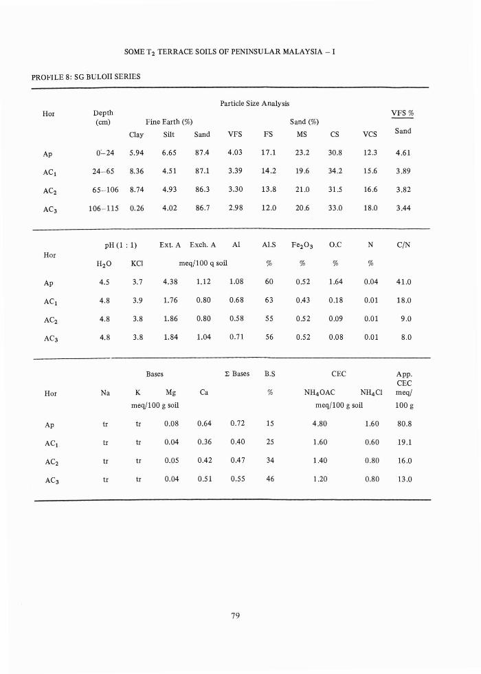
PROFILE 8: SG BULOH SERIES
Particle Size AnalysisHor Depth VFS%
(em) Fine Earth (%) Sand (%)
Clay Silt Sand VFS FS MS CS VCS Sand
Ap 0:"-24 5.94 6.65 87.4 4.03 17.1 23.2 30.8 12.3 4.61
AC l 24-65 8.36 4.51 87.1 3.39 14.2 19.6 34.2 15.6 3.89
AC2 65-106 8.74 4.93 86.3 3.30 13.8 21.0 31.5 16.6 3.82
AC3 106-115 0.26 4.02 86.7 2.98 12.0 20.6 33.0 18.0 3.44
pH (1 : 1) Ext. A Exeh. A Al Al.S Fe203 O.C N C/NHor
H2O KCI meq/100 q soil % % % %
Ap 4.5 3.7 4.38 1.12 1.08 60 0.52 1.64 0.04 41.0
AC l 4.8 3.9 1.76 0.80 0.68 63 0.43 0.18 0.01 18.0
AC2 4.8 3.8 1.86 0.80 0.58 55 0.52 0.09 0.01 9.0
AC3 4.8 3.8 1.84 1.04 0.71 56 0.52 0.08 0.01 8.0
Bases ~ Bases B.S CEC App.CEC
Hor Na K Mg Ca % NH4 0AC NH4CI meq/
meq/100 g soil meq/100 g soil 100 g
Ap tr tr 0.08 0.64 0.72 15 4.80 1.60 80.8
AC l , tr tr 0.04 0.36 0.40 25 1.60 0.60 19.1
AC2 tr tr 0.05 0.42 0.47 34 1.40 0.80 16.0
AC3 tr tr 0.04 0.51 0.55 46 1.20 0.80 13.0
79
1. SHAMSHUDDIN AND E. TESSENS
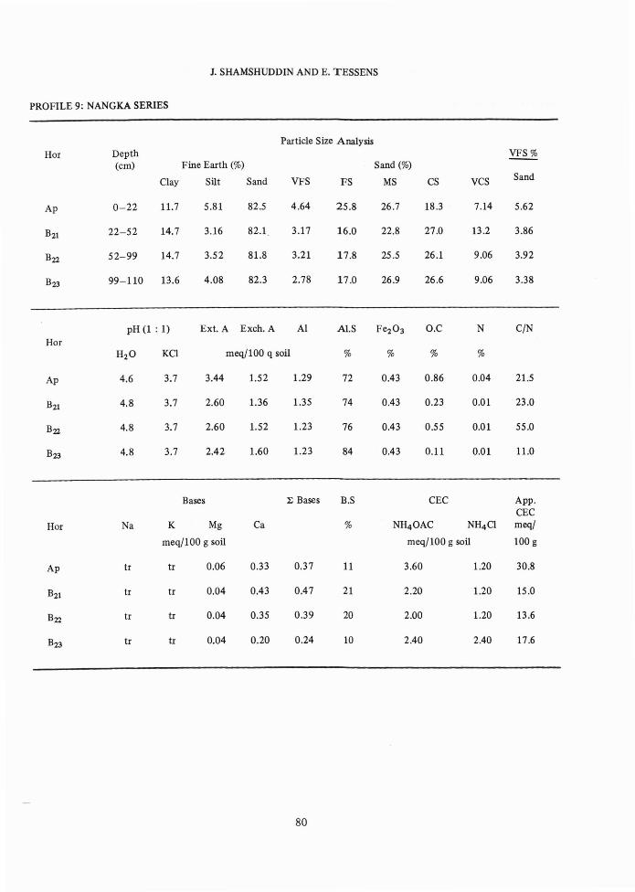
PROFILE 9: NANGKA SERIES
Particle Size AnalysisHor Depth ~
(em) Fine Earth (%) Sand (%)
Clay Silt Sand VFS FS MS CS VCS Sand
Ap 0-22 11.7 5.81 82.5 4.64 25.8 26.7 18.3 7.14 5.62
B21 22-52 14.7 3.16 82.1 3.17 16.0 22.8 27.0 13.2 3.86
B22 52-99 14.7 3.52 81.8 3.21 17.8 25.5 26.1 9.06 3.92
B23 99-110 13.6 4.08 82.3 2.78 17.0 26.9 26.6 9.06 3.38
pH (1 : 1) Ext. A Exeh. A Al AI.S Fe203 O.C N CjN
HorH2O KCI meqj100 q soil % % % %
Ap 4.6 3.7 3.44 1.52 1.29 72 0.43 0.86 0.04 21.5
B21 4.8 3.7 2.60 1.36 1.35 74 0.43 0.23 0.01 23.0
B22 4.8 3.7 2.60 1.52 1.23 76 0.43 0.55 0.01 55.0
B23 4.8 3.7 2.42 1.60 1.23 84 0.43 0.11 0.01 11.0
Bases l; Bases B.S CEC App.CEC
Hor Na K Mg Ca % NH4 0AC NH4 CI meqj
meqj100 g soil meqjlOO g soil 100 g
Ap tr tr 0.06 0.33 0.37 11 3.60 1.20 30.8
B21 tr tr 0.04 0.43 0.47 21 2.20 1.20 15.0
B22 tr tr 0.04 0.35 0.39 20 2.00 1.20 13.6
B23 tr tr 0.04 0.20 0.24 10 2.40 2.40 17.6
80
SOME T2 TERRACE SOILS OF PENINSULAR MALAYSIA - I
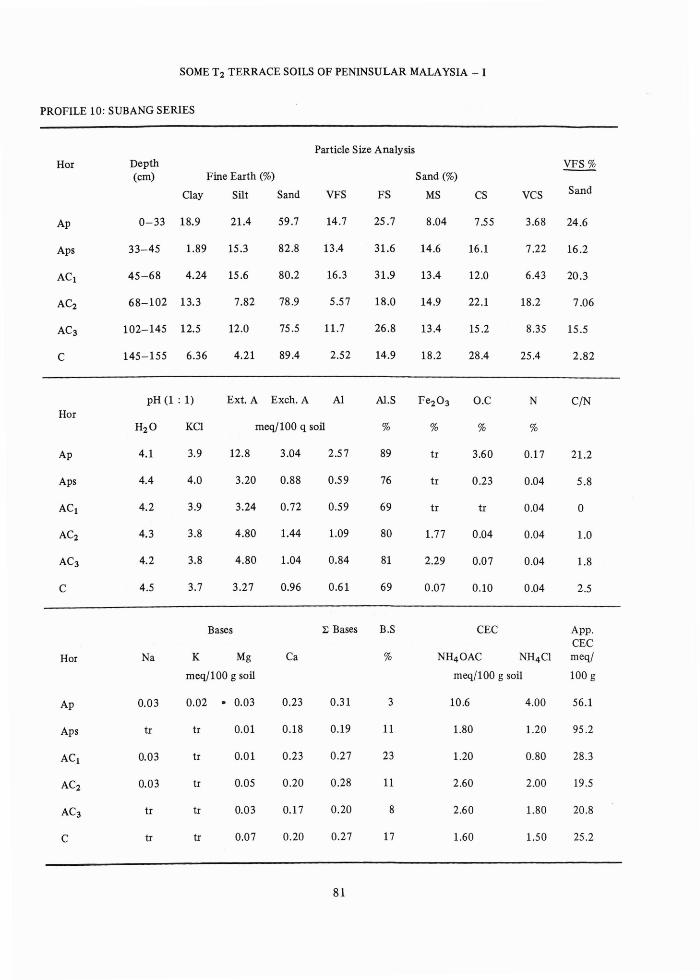
PROFILE 10: SUBANG SERIES
Particle Size AnalysisHor Depth VFS%
(em) Fine Earth (%) Sand (%)
Clay Silt Sand VFS FS MS CS VCS Sand
Ap 0-33 18.9 21.4 59.7 14.7 25.7 8.04 7.55 3.68 24.6
Aps 33-45 1.89 15.3 82.8 13.4 31.6 14.6 16.1 7.22 16.2
ACt 45-68 4.24 15.6 80.2 16.3 31.9 13.4 12.0 6.43 20.3
AC2 68-102 13.3 7.82 78.9 5.57 18.0 14.9 22.1 18.2 7.06
AC3 102-145 12.5 12.0 75.5 11.7 26.8 13.4 15.2 8.35 15.5
C 145-155 6.36 4.21 89.4 2.52 14.9 18.2 28.4 25.4 2.82
pH (1 : 1) Ext. A Exeh. A Al AI.S Fe203 O.C N C/NHor
H2O KCI meq/100 q soil % % % %
Ap 4.1 3.9 12.8 3.04 2.57 89 tr 3.60 0.17 21.2
Aps 4.4 4.0 3.20 0.88 0.59 76 tr 0.23 0.04 5.8
ACt 4.2 3.9 3.24 0.72 0.59 69 tr tr 0.04 0
AC2 4.3 3.8 4.80 1.44 1.09 80 1.77 0.04 0.04 1.0
AC3 4.2 3.8 4.80 1.04 0.84 81 2.29 0.07 0.04 1.8
C 4.5 3.7 3.27 0.96 0.61 69 0.07 0.10 0.04 2.5
Bases ~ Bases B.S CEC App.CEC
Hor Na K Mg Ca % NH4 0AC NH4 CI meq/
meq/100 g soil meq/100 g soil 100 g
Ap 0.03 0.02 • 0.03 0.23 0.31 3 10.6 4.00 56.1
Aps tr tr 0.01 0.18 0.19 11 1.80 1.20 95.2
ACt 0.03 tr 0.01 0.23 0.27 23 1.20 0.80 28.3
AC2 0.03 tr 0.05 0.20 0.28 11 2.60 2.00 19.5
AC3 tr tr 0.03 0.17 0.20 8 2.60 1.80 20.8
C tr tr 0.07 0.20 0.27 17 1.60 1.50 25.2
81
J. SHAMSHUDDIN AND E. TESSENS
PROFILE 11: SOGOMANA SERIES
Particle Size AnalysisHor Depth VFS%
(em) Fine Earth (%) Sand (%)
Clay Silt Sand VFS FS MS CS VCS Sand
Ap 0-23 45.8 46.2 8.00 0.61 0.95 1.28 2.56 2.56 7.62
B21t 23-64 34.9 62.1 3.00 0 0.26 0.52 1.24 1.04 0
B22t 64-102 66.6 31.4 2.00 0 0.17 0.29 0.68 0.80 0
pH (l : 1) Ext. A Exeh. A Al Al.S Fe203 O.C N C/NHor
H2O KCI meq/100 g soil % % % %
Ap 5.3 4.1 11.2 1.44 0.89 21 0.07 1.49 0.05 29.8
B21t 4.7 3.7 13.3 4.72 3.74 75 0.07 0.42 0.09 4.7
B22t 4.7 3.7 14.4 4.88 4.08 83 0.07 0.34 0.06 5.7
Bases :E Bases B.S CEC App.CEC
Hor Na K Mg Ca % NH40AC NH4 CI meq/
meq/100 g soil meq/lOO g soil 100 g
Ap 0.07 0.08 0.69 2.56 3.40 25 13.8 8.60 30.1
B2lt 0.08 0.08 0.23 0.87 1.25 8 15.4 15.4 44.1
B22t 0.05 0.06 0.15 0.60 0.86 6 15.0 14.6 22.5
82
SOME T2 TERRACE SOILS OF PENINSULAR MALAYSIA - I
PROFILE 12: KERAYONG SERIES
Particle Size AnalysisHor Depth VFS%
(em) Fine Earth (%) Sand (%)
Clay Silt Sand VFS FS MS CS VCS Sand
Ap 0-20 20.6 36.4 43.0 26.2 14.7 1.20 0.63 0.10 60.9
B21 20-59 28.6 34.6 36.8 20.7 14.4 1.05 0.50 0.22 56.3
B22 59-102 39.9 33.6 26.5 15.4 9.76 0.67 0.41 0.20 58.1
B23 102-150 49.9 28.8 21.3 10.1 9.30 1.35 0.25 0.10 47.4
pH (1 : 1) Ext. A Exeh. A Al Al.S Fe203 O.C N C/NHor
H2O KCI meq/100 g soil % % % %
Ap 4.3 3.6 15.2 3.12 2.35 72 0.57 2.45 0.20 12.3
B21 4.8 3.8 8.82 3.60 2.79 89 0.86 0.94 0.11 8.5
B22 4.6 3.7 13.4 4.08 3.38 92 1.36 0.33 0.11 3.0
B23 4.9 3.8 15.1 4.32 3.44 91 2.47 0.25 0.07 3.6
Bases E Bases B.S CEC App.CEC
Hor Na K Mg Ca % NH40AC NH4C1 meq/
meq/100 g soil meq/100 g soil 100 g
Ap 0.07 0.22 0.21 0.43 0.93 12 7.60 2.20 36.9
B21 0.07 0.02 0.05 0.20 0.34 4 7.80 4.40 27.3
B22 0.07 tr 0.05 0.19 0.31 5 6.00 4.60 15.0
B23 0.07 tr 0.06 0.23 0.36 4 10.0 7.10 20.0
83
J. SHAMSHUDDIN AND E. TESSENS
PROFILE 13: SG BULOH SERIES
Particle Size AnalysisHor Depth VFS%
(em) Fine Earth (%) Sand (%)
Clay Silt Sand VFS FS MS CS VCS Sand
Ap 0-24 7.46 4.97 87.6 2.95 21.2 31.1 27.5 4.64 3.37
ACt 24-75 11.1 2.54 86.4 2.75 16.5 26.7 29.6 10.7 3.18
AC2 75-123 11.9 2.92 85.2 3.65 17.9 27.3 26.5 9.65 4.28
AC3 123-133 9.19 2.11 88.7 1.76 10.5 20.6 32.5 24.0 1.98
pH (1 : 1) Ext. A Exeh. A Al Al.S Fe203 O.C N C/NHor
H2O KCI meq/100 g soil % % % %
Ap 4.8 4.1 6.30 1.68 1.40 73 0.36 1.47 0.i4 10.5
ACt 5.0 4.3 5.54 1.52 1.12 80 0.29 0.73 0.04 18.3
AC2 4.9 4.3 4.60 1.20 0.84 79 0.29 0.27 0.06 4.5
AC3 4.7 4.2 4.96 1.36 0.89 77 0.36 0.13 0.04 3.3
Bases ~ Bases B.S CEC App.CEC
Hor Na K Mg Ca % NH4 0AC NH4 CI meq/
meq/100 g soil meq/100 g soil 100 g
Ap 0.07 tr 0.04 0.41 0.52 9 6.00 2.80 84.4
ACt 0.07 tr 0.01 0.20 0.28 7 3.80 2.20 34.2
AC2 0.07 tr 0.01 0.15 0.23 8 2.80 2.00 23.5
AC3 0.07 tr 0.02 0.17 0.26 13 2.00 1.60 21.8
84
I /
SOME T2 TERRACE SOILS OF PENINSULAR MALAYSIA - I
PROFILE 14: RASAU SERIES
Particle Size AnalysisHor Depth VFS%
(em) Fine Earth (%) Sand (%)
Clay Silt Sand VFS FS MS CS VCS Sand
Al 0-10 16.7 28.7 54.6 15.5 26.7 9.44 2.75 0.27 28.4
B21 10-33 19.1 29.7 51.2 16.9 25.1 7.15 2.00 0.60 33.0
B22 33-85 17.1 34.1 48.8 16.2 23.5 6.58 1.99 0.52 33.2
B23 85-118 21.9 30.9 47.2 16.0 21.3 6.62 2.42 0.89 33.9
B24 118-128 21.8 28.6 49.6 16.4 24.4 6.52 2.10 0.67 33.1
pH (1 : 1) Ext. A Exeh. A Al A1.S Fe203 O.C N C/NHor
H2O KCI meq/100 g soil % % % %
Al 4.2 3.5 16.6 4.16 3.13 86 tr 3.95 0.22 18.0
B2I 4.4 3.9 5.50 2.88 2.51 86 tr 1.33 0.10 13.3
B22 4.6 4.0 4.24 2.64 1.98 84 tr 0.54 0.07 7.7
B23 4.7 4.0 3.98 2.72 2.21 86 tr 0.23 0.06 3.8
B24 4.8 3.9 4.18. 2.32 1.73 79 tr 0.14 0.06 2.3
Bases ~ Bases B.s CEC App.CEC
Hor Na K Mg Ca % NH40AC NH4CI meq/
meq/l 00 g soil meq/100 g soil 100 g
Al 0.12 0.18 0.040.04 0.17 0.51 4 11.6 6.00 69.5
B2I 0.07 0.04 0.04 0.25 0.40 7 5.80 5.00 30.4
Bn 0.10 0.02 0.04 0.23 0.39 8 4.60 3.80 26.9
B23 0.10 tr 0.03 0.23 0.36 9 4.20 4.00 19.2
B24 0.10 tr 0.03 0.34 0.47 12 4.00 3.60 18.3
85
J. SHAMSHUDDIN AND E. TESSENS
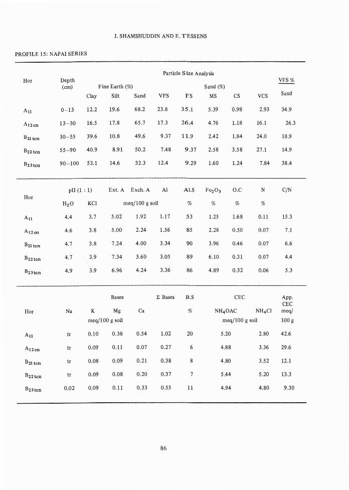
PROFILE 15: NAPAI SERIES
Particle Size AnalysisHor Depth VFS %
(em) Fine Earth (%) Sand (%)
Clay Silt Sand VFS FS MS CS VCS Sand
Au 0-13 12.2 19.6 68.2 23.8 35.1 5.39 0.98 2.93 34.9
Al2en 13-30 16.5 17.8 65.7 17.3 26.4 4.76 1.18 16.1 26.3
B2l ten 30-55 39.6 10.8 49.6 9.37 11.9 2.42 1.84 24.0 18.9
B22ten 55-90 40.9 8.91 50.2 7.48 9.37 2.58 3.58 27.1 14.9
B23ten 90-100 53.1 14.6 32.3 12.4 9.29 1.60 1.24 7.84 38.4
pH (1 : 1) Ext. A Exeh. A Al A1.S Fe203 O.C N C/NHor
H2O KCI meq/100 g soil % % % %
Au 4.4 3.7 5.02 1.92 1.17 53 1.25 1.68 0.11 15.3
Al2en 4.6 3.8 5.00 2.24 1.56 85 2.28 0.50 0.07 7.1
B2l ten 4.7 3.8 7.24 4.00 3.34 90 3.96 0.46 0.07 6.6
B22ten 4.7 3.9 7.34 3.60 3.05 89 6.10 0.31 0.07 4.4
B23tcn 4.9 3.9 6.96 4.24 3.36 86 4.89 0.32 0.06 5.3
Bases 1: Bases B.S CEC App.CEC
Hor Na K Mg Ca % NH4 0AC NH4 CI meq/
meq/100 g soil meq/lOO g soil 100 g
Au tr 0.10 0.38 0.54 1.02 20 5.20 2.80 42.6
Al 2en tr 0.09 0.11 0.07 0.27 6 4.88 3.36 29.6
B2l ten tr 0.08 0.09 0.21 0.38 8 4.80 3.52 12.1
B22ten tr 0.09 0.08 0.20 0.37 7 5.44 5.20 13.3
B23ten 0.02 0.09 0.11 0.33 0.55 11 4.94 4.80 9.30
86

SOME T2 TERRACE SOILS OF .fENINSULAR MALAYSIA - I
PROFILE 16: CHUPING SERIES
Particle Size AnalysisHOI Depth VFS%
(em) Fine Earth (%) Sand (%)
Clay Silt Sand VFS FS MS CS VCS Sand
Al 0-14 8.36 38.9 52.7 27.8 19.0 4.13 1.46 0.67 52.8
B21 t 14-35 10.7 32.5 56.8 23.4 22.1 6.28 3.12 1.74 41.2
B22tcn 35-63 26.5 24.8 48.7 13.5 13.3 5.09 3.93 12.8 27.7
llB3 63-73 58.5 23.8 17.7 8.57 4.50 1.63 1.79 1.36 48.5
C 73+
pH (1 : 1) Ext. A Exeh. A Al Al.S Fe203 O.C N C/NHor
H2O KCI meq/100 g soil % % % %
Al 5.3 4.1 8.22 1.20 0.42 20 0.88 0.60 0.07 8.6
B2lt 5.3 3.9 9.22 2.00 1.06 52 1.72 0.52 0.06 8.7
B22tcn 5.6 3.8 11.2 3.28 2.61 51 4.05 0.26 0.06 4.3
llB3 7.4 5.8 0.86 0.24 0 0 5.26 tr 0.06 0
Bases ~ Bases B.S CEC App.CEC
Hor Na K Mg Ca % NH4 0AC NH4 CI meq/
meq/100 g soil meq/IOO g soil 100 g
Al tr 0.08 0.55 1.01 1.64 34 4.80 2.88 57.4
B2lt tr 0.08 0.55 1.01 1.64 34 4.80 2.88 57.4
B2lt tr 0.05 0.47 0.45 0.97 25 3.84 3.68 35.9
B22tcn 0.04 0.09 1.39 0.95 2.47 18 13.4 12.0 50.6
llB3 0.54 0.10 11.8 8.73 21.2 100 25.2 21.2 43.1
87
J. SHAMSHUDDIN AND E. TESSENS
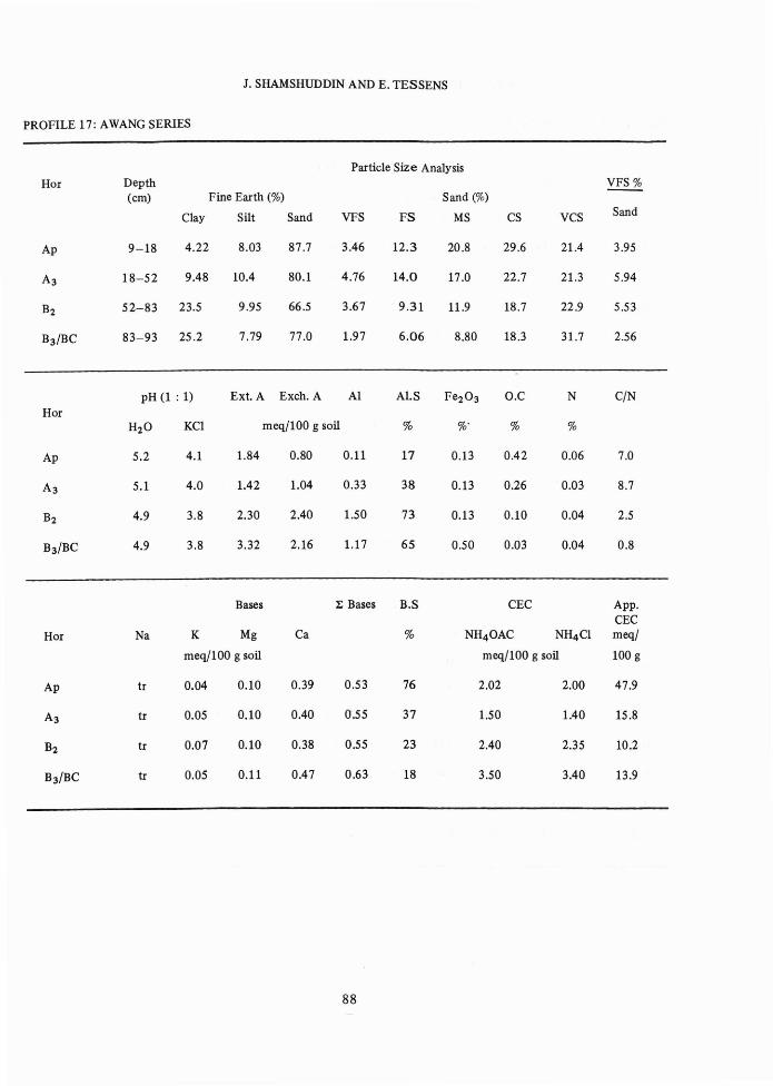
PROFILE 17: AWANG SERIES
Particle Size AnalysisHor Depth ~
(em) Fine Earth (%) Sand (%)
Clay Silt Sand VFS FS MS CS VCS Sand
Ap 9-18 4.22 8.03 87.7 3.46 12.3 20.8 29.6 21.4 3.95
A3 18-52 9.48 10.4 80.1 4.76 14.0 17.0 22.7 21.3 5.94
B2 52-83 23.5 9.95 66.5 3.67 9.31 11.9 18.7 22.9 5.53
B3/BC 83-93 25.2 7.79 77.0 1.97 6.06 8.80 18.3 31.7 2.56
pH (1 : 1) Ext. A Exeh. A Al Al.S Fe203 O.C N C/NHor
H2O KCI meq/100 g soil % %. % %
Ap 5.2 4.1 1.84 0.80 0.11 17 0.13 0.42 0.06 7.0
A3 5.1 4.0 1.42 1.04 0.33 38 0.13 0.26 0.03 8.7
B2 4.9 3.8 2.30 2.40 1.50 73 0.13 0.10 0.04 2.5
B3/BC 4.9 3.8 3.32 2.16 1.17 65 0.50 0.03 0.04 0.8
Bases :E Bases B.S CEC App.CEC
Hor Na K Mg Ca % NH40AC NH4CI meq/
meq/lOO g soil meq/100 g soil 100 g
Ap tr 0.04 0.10 0.39 0.53 76 2.02 2.00 47.9
A3 tr 0.05 0.10 0.40 0'.55 37 1.50 1.40 15.8
B2 tr 0.07 0.10 0.38 0.55 23 2.40 2.35 10.2
B3/BC tr 0.05 0.11 0.47 0.63 18 3.50 3.40 13.9
88
SOME T2 TERRACE SOILS OF PENINSULAR MALAYSIA - I
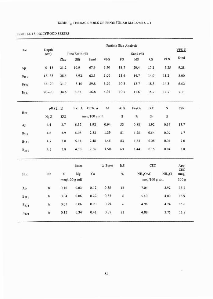
PROFILE 18: HOLYROOD SERIES
Particle Size AnalysisHor Depth VFS%
(em) Fine Earth (%) Sand (%)
Clay Silt Sand VFS FS MS CS VCS Sand
Ap 0-18 21.2 10.9 67.9 6.30 18.7 20.4 17.1 5.25 9.28
B2lt 18-35 28.6 8.92 62.5 5.00 13.4 14.7 14.0 11.2 8.00
B22t 35-70 31.7 8.45 59.8 3.90 10.3 12.7 18.3 14.3 6.52
B23t 70-90 34.6 8.62 56.8 4.04 10.7 11.6 15.7 14.7 7.11
pH (l : 1) Ext. A Exeh. A Al Al.S Fe203 lJ.C N C/NHor
H2O KCl meq/100 g soil % % % %
Ap 4.4 3.7 6.32 1.92 0.94 53 0.88 1.92 0.14 13.7
B21t 4.8 3.9 5.08 2.32 1.39 81 1.25 0.54 0.07 7.7
B22t 4.7 3.8 5.14 2.48 1.45 83 1.53 0.28 0.04 7.0
B23t 4.5 3.8 4.78 2.56 1.50 63 1.44 0.15 0.04 3.8
Bases 1; Bases B.S CEC App.CEC
Hor Na K Mg Ca % NH40AC NH4Cl meq/
meq/100 g soil meq/100 g soil 100 g
Ap tr 0.10 0.03 0.72 0.85 12 7.04 3.92 33.2
B21t tr 0.04 0.06 0.22 0.32 6 5.40 4.00 18.9
B22t tr 0.03 0.06 0.20 0.29 6 4.96 4.24 15.6
B23t tr 0.12 0.34 0.41 0.87 21 4.08 3.76 11.8
89