Paleomagnetic evidence for clockwise rotation and tilting ... · Paleomagnetic evidence for...
15
Paleomagnetic evidence for clockwise rotation and tilting in the eastern Tethyan Himalaya (SE Tibet): Implications for the Miocene tectonic evolution of the NE Himalaya Borja Antolín a, ⁎, Erwin Appel a , Richard Gloaguen b , István Dunkl c , Lin Ding d , Chiara Montomoli e , Ursina Liebke a , Qiang Xu d a Institute for Geosciences, University of Tübingen, Sigwartstrasse 10, 72076 Tübingen, Germany b Department of Geology, Technical University of Freiberg, Bernhard-von-Cottastrasse 2, 09596 Freiberg, Germany c Sedimentology and Environmental Geology, University of Göttingen, Goldschmidtstrasse 3, D-37077 Göttingen, Germany d Institute of Tibetan Plateau Research, Chinese Academy of Sciences, Shuangqing Rd. 18, Beijing 100085, China e Department of Earth Sciences, University of Pisa, via S. Maria 53, 56126 Pisa, Italy abstract article info Article history: Received 26 January 2010 Received in revised form 10 July 2010 Accepted 20 July 2010 Available online 30 July 2010 Keywords: Tethyan Himalaya Paleomagnetism Pyrrhotite SE Tibet Miocene Tectonics Crustal movement around and away from the Namche Barwa syntaxis is indicated in the Asian velocity field inferred from GPS data and Quaternary fault slip rates. Nevertheless, there is a limited field-based control on the rotational history of the north-eastern Himalayan arc. Exploring the poly-phase nature of deformation, within the Cretaceous diorite dykes and their host-rock (Triassic flysch), in the eastern Tethyan Himalaya (90°–92°E), combined with new remote sensing data and existing thermo-geochronological data, allow us to unravel the kinematic relationship between paleomagnetic remanence vectors and the deformation phases. Decay at 325 °C in high temperature susceptibility curves and in the thermal demagnetization of the SIRM indicate that the characteristic remanent magnetization in the Cretaceous diorite dykes is carried by pyrrhotite. The pyrrhotite component unblocks at 280–350 °C, revealing normal and reverse polarities. It is of post-folding origin with a mean remanence direction of 019°/28° and 001°/20° in the eastern (Qonggyai valley) and western (Nagarze) part of the sampling area, respectively. The ~22 Ma K–Ar age of the last metamorphic event support that the remanence is post-Eohimalayan folding and likely of thermoremanent or thermo-chemical origin. Comparison of the declination with respect to the Early-Miocene reference direction, yields a trend from no apparent rotation in the west to 20° clockwise rotation in the east with respect to the stable Indian plate. This result can be kinematically related to the Middle to Late-Miocene strain partitioning between far-field southeast extrusion of SE Tibet and near-field strike-slip faulting and E–W extension. Furthermore the observed pattern of tilting around horizontal axis may reflect concealed North Himalayan doming. © 2010 Elsevier B.V. All rights reserved. 1. Introduction The indentation of the Indian plate into the Eurasian plate and ongoing north–south convergence of both continents resulted in large-scale shortening of Greater India (Ali and Aitchison, 2005) and the rise of the Himalayan belt around ~55 Ma (e.g. Gaetani and Garzanti, 1991; Guillot et al., 2003; Liebke et al., in press). Since these two tectonic plates collided three simplified mechanisms have controlled the Himalayan architecture: N–S shortening, N–S exten- sion and orogen-parallel extension (Searle, 1996; Hodges, 2000; Yin and Harrison, 2000 for reviews). How these end members processes are partitioned along time plays a key role for the interpretation and modeling of the uplift of the Himalaya and the Tibetan plateau. The present study focuses on SE Tibet, a cornerstone area in the kinematic evolution of the Himalaya–Tibet system because of its structural position in between two tectonic domains: the Himalayan domain, controlled by N–S shortening and E–W extension (since Middle Miocene; e.g Armijo et al., 1986; Jessup et al., 2008), and the Tibetan domain governed by ESE–WNW extension and southeast- ward and eastward movement of crustal material (since Middle Miocene, e.g. Tapponnier et al., 1982; Royden et al., 1997; Zhang et al., 2004). The far east of southern Tibet, close to the eastern Himalayan syntaxis, is a region where the indentation of India presently creates strong lateral inhomogeneity of deformation (Armijo et al., 1989; Royden et al., 1997; Holt et al., 2000). Eastward motion is evident by GPS velocities which indicate motion around and away from the Tectonophysics 493 (2010) 172–186 ⁎ Corresponding author. Tel.: +49 70 71/29 78931; fax: +49 7071 29 5842. E-mail addresses: [email protected], [email protected] (B. Antolín), [email protected] (R. Gloaguen), [email protected] (I. Dunkl), [email protected] (L. Ding), [email protected] (C. Montomoli). 0040-1951/$ – see front matter © 2010 Elsevier B.V. All rights reserved. doi:10.1016/j.tecto.2010.07.015 Contents lists available at ScienceDirect Tectonophysics journal homepage: www.elsevier.com/locate/tecto
Transcript of Paleomagnetic evidence for clockwise rotation and tilting ... · Paleomagnetic evidence for...
Tectonophysics 493 (2010) 172–186
Contents lists available at ScienceDirect
Tectonophysics
j ourna l homepage: www.e lsev ie r.com/ locate / tecto
Paleomagnetic evidence for clockwise rotation and tilting in the eastern TethyanHimalaya (SE Tibet): Implications for the Miocene tectonic evolution of theNE Himalaya
Borja Antolín a,⁎, Erwin Appel a, Richard Gloaguen b, István Dunkl c, Lin Ding d, Chiara Montomoli e,Ursina Liebke a, Qiang Xu d
a Institute for Geosciences, University of Tübingen, Sigwartstrasse 10, 72076 Tübingen, Germanyb Department of Geology, Technical University of Freiberg, Bernhard-von-Cottastrasse 2, 09596 Freiberg, Germanyc Sedimentology and Environmental Geology, University of Göttingen, Goldschmidtstrasse 3, D-37077 Göttingen, Germanyd Institute of Tibetan Plateau Research, Chinese Academy of Sciences, Shuangqing Rd. 18, Beijing 100085, Chinae Department of Earth Sciences, University of Pisa, via S. Maria 53, 56126 Pisa, Italy
⁎ Corresponding author. Tel.: +49 70 71/29 78931; fE-mail addresses: [email protected], b
(B. Antolín), [email protected] (R. Gloaguen)[email protected] (I. Dunkl), dinglin@[email protected] (C. Montomoli).
0040-1951/$ – see front matter © 2010 Elsevier B.V. Adoi:10.1016/j.tecto.2010.07.015
a b s t r a c t
a r t i c l e i n f oArticle history:Received 26 January 2010Received in revised form 10 July 2010Accepted 20 July 2010Available online 30 July 2010
Keywords:Tethyan HimalayaPaleomagnetismPyrrhotiteSE TibetMioceneTectonics
Crustal movement around and away from the Namche Barwa syntaxis is indicated in the Asian velocity fieldinferred from GPS data and Quaternary fault slip rates. Nevertheless, there is a limited field-based control onthe rotational history of the north-eastern Himalayan arc. Exploring the poly-phase nature of deformation,within the Cretaceous diorite dykes and their host-rock (Triassic flysch), in the eastern Tethyan Himalaya(90°–92°E), combined with new remote sensing data and existing thermo-geochronological data, allow us tounravel the kinematic relationship between paleomagnetic remanence vectors and the deformation phases.Decay at 325 °C in high temperature susceptibility curves and in the thermal demagnetization of the SIRMindicate that the characteristic remanent magnetization in the Cretaceous diorite dykes is carried bypyrrhotite. The pyrrhotite component unblocks at 280–350 °C, revealing normal and reverse polarities. It isof post-folding origin with a mean remanence direction of 019°/28° and 001°/20° in the eastern (Qonggyaivalley) and western (Nagarze) part of the sampling area, respectively. The ~22 Ma K–Ar age of the lastmetamorphic event support that the remanence is post-Eohimalayan folding and likely of thermoremanentor thermo-chemical origin. Comparison of the declination with respect to the Early-Miocene referencedirection, yields a trend from no apparent rotation in the west to 20° clockwise rotation in the east withrespect to the stable Indian plate. This result can be kinematically related to the Middle to Late-Miocenestrain partitioning between far-field southeast extrusion of SE Tibet and near-field strike-slip faulting and E–Wextension. Furthermore the observed pattern of tilting around horizontal axis may reflect concealed NorthHimalayan doming.
ax: +49 7071 29 [email protected],mail.igcas.ac.cn (L. Ding),
ll rights reserved.
© 2010 Elsevier B.V. All rights reserved.
1. Introduction
The indentation of the Indian plate into the Eurasian plate andongoing north–south convergence of both continents resulted inlarge-scale shortening of Greater India (Ali and Aitchison, 2005) andthe rise of the Himalayan belt around ~55 Ma (e.g. Gaetani andGarzanti, 1991; Guillot et al., 2003; Liebke et al., in press). Since thesetwo tectonic plates collided three simplified mechanisms havecontrolled the Himalayan architecture: N–S shortening, N–S exten-sion and orogen-parallel extension (Searle, 1996; Hodges, 2000; Yin
and Harrison, 2000 for reviews). How these end members processesare partitioned along time plays a key role for the interpretation andmodeling of the uplift of the Himalaya and the Tibetan plateau.
The present study focuses on SE Tibet, a cornerstone area in thekinematic evolution of the Himalaya–Tibet system because of itsstructural position in between two tectonic domains: the Himalayandomain, controlled by N–S shortening and E–W extension (sinceMiddle Miocene; e.g Armijo et al., 1986; Jessup et al., 2008), and theTibetan domain governed by ESE–WNW extension and southeast-ward and eastward movement of crustal material (since MiddleMiocene, e.g. Tapponnier et al., 1982; Royden et al., 1997; Zhang et al.,2004). The far east of southern Tibet, close to the eastern Himalayansyntaxis, is a region where the indentation of India presently createsstrong lateral inhomogeneity of deformation (Armijo et al., 1989;Royden et al., 1997; Holt et al., 2000). Eastward motion is evidentby GPS velocities which indicate motion around and away from the
173B. Antolín et al. / Tectonophysics 493 (2010) 172–186
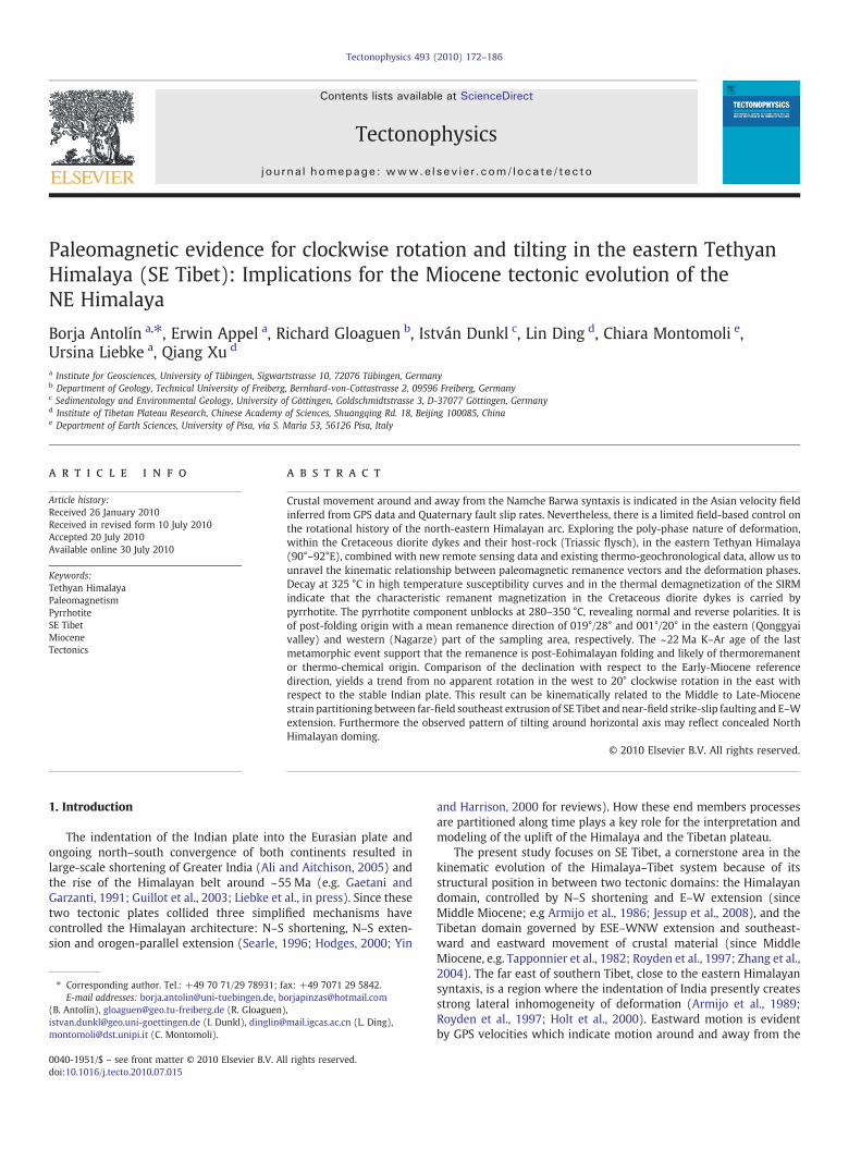
eastern syntaxis (e.g. Gan et al., 2007; Fig. 1a). However, there iscurrently limited field-based studies on the rotational history of theeastern Himalayan arc (Li and Yin, 2008), which can be utilized toconstrain the mechanisms that have controlled part of the kinematicevolution of the eastern Himalayan Belt and SE part of the Tibetanplateau. The present study utilizes new measured paleomagneticremanence directions, widely proved as a powerful tool in distinguish-ing between different kinematic models of deformation in orogens(Weil and Sussman, 2004), e.g. Apalachian mountains (Eldredge et al.,1985), Pyrenees belt (Oliva-Urcia and Pueyo, 2007); Patagonianorocline (Maffione et al., 2009). In the Himalayan orogen paleomag-netism has been applied to quantify vertical-axis block rotations in thewestern Himalaya reflecting the indentation of India into Eurasia andthe development of thewestern syntaxis. The block rotation pattern inthewestern syntaxis describes a clockwise rotation in the eastern zoneof the syntaxis and counterclockwise rotations in the western partsince remanence acquisition at ~50–40 Ma (Klootwijk et al., 1985;Appel et al., 1995; Schill et al., 2001). These results have been utilizedto interpret the mechanism of the formation of the Nanga ParbatHaramosh syntaxis as pure-bending, also called oroclinal bending(Schill and Holt, 2004). Further to the east (western to central Nepal)Schill et al. (2004) obtained an increasing trend to clockwise rotationsin the Tethyan Himalaya remanence directions from Hidden valley inthe west (83.6°E) to Shiar valley in the east (85.1°E), for remanenceacquisition ages ~30–25 Ma (Fig. 1b). This was interpreted as a resultof a large-scale dextral shear zone associated with the eastwardextrusion of the Tibetan plateau (Schill et al., 2004). Further to the eastbetween the Shiar valley and the study area there are no paleomag-netic data published until present.
In this paper, we report new paleomagnetic results from theCretaceous diorite dykes widely exposed within the Triassic flysch inthe eastern Tethyan Himalaya (90°–92°E). These are combined withstructural data, remote sensing analysis and the existing K–Ar
Fig. 1. a) selected and slightly generalized GPS velocity field relative to stable Eurasia (afteb) simplified geological map of the central and eastern Himalaya (after Lee et al., 2000; Pan ethe Tethyan Himalaya (Schill et al., 2004 and references therein): D, Dolpo; HV, Hidden valrotations calculated in this study: N, Nagarze and Q, Qonggyai. TKG, Thakkhola Graben; IYSZNagarze; Qo, Qonggyai; CG, Cona Graben; STDS, South Tibetan Detachment System; KT, KakHimalayan sequence; MBT, Main Boundary Thrust. Sense of strike slip-faults close to the IYS1994).
geochronology, Kübler Index (illite crystallinity) and vitrinite reflec-tance data from the Triassic flysch. Outcome from these sourcesprovide vertical-axis block rotations and tilt around the horizontalaxis to constrain the Miocene kinematic evolution and deformationmechanisms in the NE Himalayan region.
2. Geological setting
2.1. Boundaries and deformation of the Tethyan Himalayan sequence
The study area is located in the eastern TethyanHimalayan sequence(THS) in SE Tibet, between the north dipping normal faults of the SouthTibetan Detachment System (STDS) (e.g. Pêcher et al., 1991; Burchfielet al., 1992; Carosi et al., 1998) and the Indus Yarlung suture zone (IYSZ)(Gansser, 1964; Fig.1b). The THS is the cover of the Greater Himalayansequence (GHS) which has been probably exhumed during contempo-raneous normal-sense ductile shearing along the STDS and the south-vergent thrusting on the Main Central Thrust (MCT) (Burchfiel et al.,1992; Grujic et al., 2002) at about 24–12 Ma for the whole Himalaya(Godin et al., 2006 and references therein).
The IYSZ is complexly affected by the development of theGangdese Thrust system, the Great Counter Thrust (GCT) and locallystrike-slip and normal fault systems (Yin et al., 1994; Harrison et al.,2000; Ding et al., 2005).
The THS represents a ~150 km wide zone comprising a strati-graphic record of sedimentation at the northern continental margin ofIndia from Paleozoic to Eocene times (Gaetani and Garzanti, 1991;Willems et al., 1996). Despite differences between studies alongdifferent profiles, five main and common events have controlled theactual view of the structure in the THS. In geochronological orderthese are south-verging isoclinal folds with related axial planefoliation (Eocene to Early Oligocene; e.g. Burg and Chen, 1984;Ratschbacher et al., 1994; Hodges, 2000), north-vergent folds with
r Gan et al., 2007). MFT, Main Frontal Thrust; KF, Kunlun Fault; ATF, Altyn Tagh Fault.t al., 2004; and Kellett et al., 2009) with the published paleomagnetic block rotations inley; Th, Thakkhola; M, Manang; N–P, Nar/Phu; L, Larkya; S, Shiar. Paleomagnetic block, Indus Yarlung suture zone; ADM, Ama Drime Massif; YGG, Yadong–Gulu Graben; Na,htang thrust; GHS, Greater Himalayan sequence; MCT, Main Central Thrust; LHS, LesserZ: South of Xigaze and in Bainang (Ratschbacher et al., 1994) and in Renbu (Yin et al.,
174 B. Antolín et al. / Tectonophysics 493 (2010) 172–186
axial plane foliation (Oligocene to Early Miocene; Godin, 2003;Montomoli et al., 2008; Kellett and Godin, 2009), top-to-the NEdisplacement along the STDS and north-vergent backthrustingactivity on the GCT (Middle Miocene; e.g. Harrison et al., 2000; Carosiet al., 2002; Dunkl et al., in press), exhumation of the North Himalayandomes (Miocene; see Leech, 2008 for an updated review), N–S normalfaults and seven major N–S-trending graben structures related to E–Wextension (LateMiocene; e.g. Armijo et al., 1986; Searle, 1996; Garzioneet al., 2003; Jessup et al., 2008; Fig. 1b).
2.2. Sampling and lithology of the studied area
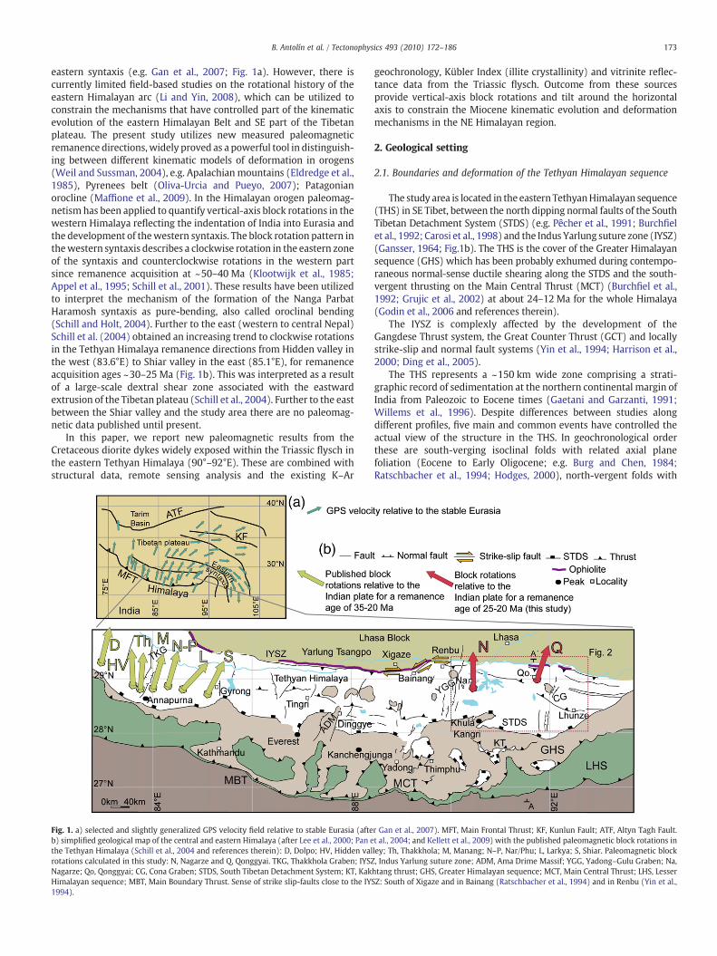
We collected paleomagnetic samples from 30 sites in SE Tibet alongtwoN–S profiles of about 30 km from29°10′N to 28°54′Nand separatedby 130 km in E–W direction. One transect is located in Nagarze–Yamdrock Lake area (90°19′E) with 10 sites and the other in theQonggyai valley (91°40′E) with 20 sites (Fig. 2a). The studied rocks are
Fig. 2. a) lithotectonic map of the study area in SE Tibet after Harrison et al. (2000), Pan et al. (map of Pan et al. (2004), Aikman et al. (2008) and data from Montomoli et al. (2008) andSystem; GHS, Greater Himalayan sequence. c) equal-area lower-hemisphere stereogram of S1measured north of Qonggyai and east of Zetang. e) stereogram with S0 and S1 foliation me
diorite, diabase and dolerite dykes intruded in the Triassic flysch. Thesedykes were sampled 15 km south of the IYSZ and 85–100 km north ofSTDS. The thicknessof thedykes ranges from1 mto~100 m.The textureand the typical crystal size are very variable, changing from very coarse-grained holocrystalline to fine grained, nearly aphanitic. In theultramafic members poikilitic or cummulate textures are typical.Some of the magmatic bodies and typically their interior parts showwell conserved magmatic textures, but in many outcrops the dykes arestrongly deformed and transformed to chlorite or amphibole schists.The margins and contact aureoles of the dykes are mainly alterated tobanded, chaotic and mica-rich zones (Dunkl et al., in press). Close toNagarze SHRIMP U–Pb dating of mafic dykes indicate emplacement ageof 135–133 Ma (Zhu et al., 2008; Xu et al., 2009). Genesis of the studieddykes has been related to a progressive lithosphere thinning beneatheastern Gondwanaland during early Cretaceous (Zhu et al., 2008). Thedykes are generally deformed within the flysch and have been affectedby the main regional tectonic events above described.
2004) and Aikman et al. (2008). b) cross section along the Qonggyai valley transect afterAntolín et al. (in press). GCT, Great Counter Thrust. STDS, South Tibetan Detachmentfoliationmeasured in Nagarze and Yamdrock lake area. d) stereogramwith S2 foliationasured south of Qonggyai.
175B. Antolín et al. / Tectonophysics 493 (2010) 172–186
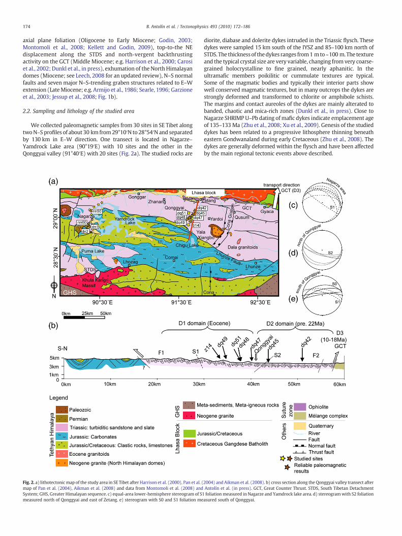
2.3. Tectonic architecture and metamorphism in the Qonggyai valley
The Qonggyai valley exposes the Triassic flysch and diorite dykesalong ca. 40 km between the south dipping GCT in the north and theLhunze fault in the south (Fig. 2a,b). TheGCT systembrings the Triassicflysch over themélange complex, ophiolites and Cretaceous sedimentsof Eurasian affinity (e.g., Yin et al., 1994; Harrison et al., 2000; Dupuiset al., 2006). The Lhunze fault trends from NW–SE to E–W and dips tothe N (Aikman et al., 2008), separating the Triassic flysch (hanging-wall) from the Cretaceous and Upper Jurassic rocks (footwall). The
Fig. 3. a) sketch of structural relationship between deformation phases within the Triassid) studied site dq47. e and f) picture of the contact between dyke and flysch and interpretatiostereogram of S1 foliation in site dq47.
flysch sediments, turbiditic sandstones and slates, were deposited inan abyssal andbathyal environment betweenMiddle Triassic and EarlyJurassic (Dupuis et al., 2006). South of the Lhunze fault the Cretaceousclastic rocks, limestones and Upper Jurassic continental clastic rocks,marls and marine limestones represent the platform sequence of theIndianpassivemargin (Fig. 2a) (Liu and Einsele, 1994; Pan et al., 2004).
The flysch pile within these two thrusts describes a double vergentwedge derived from the multi-phase tectonic history of the TethyanHimalaya. The Triassic flysch has been affected by four main de-formation phases (Fig. 3a). The southern portion, approximately
c flysch. b and c) picture and interpretation of F1 folds close to sites dq48 and dq51.n of the foliation developed in the margin of the dyke. g) equal-area lower-hemisphere
176 B. Antolín et al. / Tectonophysics 493 (2010) 172–186
between the Lhunze fault and Qonggyai is dominated by D1 structurestypically of Eohimalayan age (Hodges, 2000). It is characterized by E–Wisoclinal F1 folds and related axial planar foliation S1 trending E–Wwithdip to theN(Montomoli et al., 2008) (Figs. 2b,c,e and3a). Fig. 3b shows adecametric folded diorite dyke (F1 fold) parallel to the Triassic flysch F1folds (Fig. 3c). Stretching lineation, obtained from anisotropy ofmagnetic susceptibility data, south of Qonggyai trend SSW–NNE withintermediate plunges to the N and has been related to southwardmotion of flysch slices along thrust planes towards the Himalayanforeland in consonance with the main southward vergence of theorogen (Antolín et al., in press). Locally S1 can occur steeply dippingtoward the S as in the area around Qonggyai village, due to thedevelopment of later collapse folds with sub-horizontal axial plane.Fig. 3d,g shows S1 foliation in the margin of a dyke parallel to thefoliation of the neighboring slates (site dq47 in Fig. 2a,b). Moving to thenorth the flysch is characterized by north-vergent F2 decametric foldsand microfolds which deform the S1 foliation (Montomoli et al., 2008).Approaching the GCT the flysch structure is controlled by S2 foliationtrending E–W and dipping to the south, caused by hinterland pro-pagation of the deformation (D2 deformation phase; Figs. 2d and 3a).K–Ar isotope radiogenic ages in newly grown illites near site dq45,within the D2 domain, show ~22 Ma cooling ages which have beenrelated to peak metamorphism during the D2 phase (Dunkl et al.,2008; Antolín et al., in press). DuringD2 the Triassicflysch and dioritedykes underwent anchi- to epizonal metamorphic conditions, asindicated Kübler Index values (Dunkl et al., in press). Continuation ofbackward deformation towards higher structural levelswas probablyresponsible for the formation of the north-directed GCT around18 Ma to 10 Ma (D3 phase; Fig. 3a) (Yin et al., 1994; Harrison et al.,2000; Antolín et al., in press).
The Yala Xiangbo North Himalayan dome (Fig. 2a) was emplacedat ca. 18 Ma and cooled at ca. 13.5 Ma (Aikman et al., 2004). Finallyorogen parallel extension (E–W) dominates the orogen architecture,which trigger kilometer-scale N-trending normal faults during thePliocene; D4 phase (e.g. Armijo et al., 1986; Fig. 3a). The study area isbounded to the west by the Yadong Gulu Graben (90°E) and is cross-cut by the easternmost Himalayan Graben, the Cona Graben at ~92°E(Figs. 1b and 2a; Armijo et al., 1986; Garzione et al., 2003). GPSvelocities indicate no significant (0.3±0.9 mm/yr) fault opening atpresent-day in the Cona Graben and 2.0±0.6 mm/yr opening rate inthe Yadong–Gulu Graben (Gan et al., 2007).
3. Methods
3.1. Sampling and paleomagnetic laboratory procedure
In general 10 cores with 2.5 cm in diameter were taken from eachsite using a portable gasoline powered drill. A magnetic compass wasused for in situ core orientation. Deviation due to rock magnetizationcan be considered as negligible as the content of ferromagneticminerals in the dykes is relatively low (magnetic susceptibility aver-aged for 16 sites, 170 samples, is 650.1×10⁻⁶ SI). The declination ofthe ambient magnetic field was 0° during the sampling campaignperiod (NOAA's National Geophysical Data Centre, http://www.ngdc.noaa.gov). The cores were cut into specimens of standard size (2.2 cmlength). Sampling was focused in the margin of the dykes wheresulphur migration from the neighboring slates could increase theoriginal sulphur content of the dyke and result in the formation ofpyrrhotite. Two sites (dq48 and dq51) could be drilled within thelimbs of a decametric isoclinal fold deformedwithin the Triassic flysch(Fig. 3c). Differences of foliation attitudes in the neighboring flyschand at the margin of the dykes allow tectonic correction of the sitesand the application of fold tests.
Rock magnetic experiments were elaborated to determine thenature of the carrier of characteristic remanence magnetization(ChRM): Low and high temperature thermo-magnetic curves using a
CS3 unit coupledwith a Kappabridge KLY-3 (AGICO), acquisition curvesof isothermal remanent magnetization (IRM) in a stepwise increasingDC field up to 1.9 T at room temperature using an MMPM9 pulsemagnetizer (Magnetic Measurements) and stepwise thermal demag-netization of the saturation IRM (SIRM). Furthermore in 3 selectedsamples we performed low-temperaturemeasurements down to 5 K ina zero field environment using a Magnetic Properties MeasurementSystem (MPMS)-XL7 magnetometer (Quantum Design Ltd.).
Demagnetization procedures were first performed on pilot speci-mens (two samples per site). Alternating field stepwise demagneti-zation (AfD) of natural remanent magnetization (NRM) wasperformed using an automatic degausser (2G600) coupled to athree-axis SQUID magnetometer (RF SQUID 760 R, 2G Enterprises).This magnetometer was also used to measure the magnetizationremaining after each step of heating. Stepwise thermal demagnetiza-tion (ThD) of NRM and SIRM were performed utilizing a thermalspecimen demagnetizer, model TD-48SC (ASC Scientific). Suscepti-bility was monitored after each step of ThD to control changes in themagnetic mineralogy using a Kappabridge KLY-2 (AGICO). Aftercomparison of the twomethods, ThDwas chosen for demagnetizationof the bulk samples. AfD did not reach complete demagnetization andfurthermore ThD showed more stable demagnetization behavior.ChRM directions for each sample were computed by principalcomponent analysis (Kirschvink, 1980). Sites means were determinedby Fisher (1953); single specimen directions with reverse polaritywere inverted before averaging. Fold tests were performed afterMcFadden (1990). The present-day GAD direction for the samplingarea was calculated by means of the program IGRF version 4. Allmagnetic measurements were done in the paleomagnetic laboratoryat the University of Tübingen except MPMS measurements whichwere carried out at University of Bremen.
3.2. Neotectonic analysis
Rivers flowing along bedrock channels are the primary non-glacialmechanism of incision. The rate at which channels incise sets the rateat which the rest of the landscape evolves, and hence may control theresponse time of such landscapes to tectonic forcing (e.g. Jacksonet al., 1996; Gloaguen et al., 2008). The drainage network is extractedfrom SRTM v.4 data by calculating flow directions at all points usingthe D8 algorithm. Stream longitudinal profiles are identified andselected based upon least cost path analyses (Shahzad and Gloaguen,in press-a). We compute paths of least down slope resistance (i.e. thedownstream flow path) and Strahler's stream order. Incisionmaps, i.e.the local relief within a moving window, provide useful informationfor the determination of neotectonic features (e.g. Käßner et al.,2008). The spatial organisation of a river system and its space fillingproperties (e.g. dendritic and orthogonal) can be strongly controlledby tectonics (e.g. Jackson et al., 2002; Gloaguen et al., 2007). Theiranalysis provides first hand clues to characterize tectonic forcing onlandscape formation (e.g. Burbank et al., 1996; Shahzad et al., 2009).Analysis of basin asymmetry can provide important map-scale datafor neotectonic assessment, allowing the delineation of geomorphicdomains of streammigration that may be related to tilting fault blocksor developing folds (e.g., Cox et al., 2001). As streams respond to upliftor subsidence by migrating laterally in a down-tilt direction, a recordof this migration is preserved as an asymmetric position of the mainbasin river with respect to the watershed axis. This technique pro-duces a vector field (T-factors) of spatially averaged directions of basinasymmetry (inferring lateral stream migration), and areas showingpreferred directions of stream migration can be evaluated in terms oftectonic forcing. A semi-automated method of analysis which deliversthe T-factor morphometric index from a Digital Elevation Model(DEM) has been implemented on MATLAB (Shahzad and Gloaguen,in press-b). From these vector data, different spatial domains can be
177B. Antolín et al. / Tectonophysics 493 (2010) 172–186
drawn, whereas the offset directions contribute to constraint themain active strain orientation.
4. Paleomagnetic results
4.1. Rock magnetism
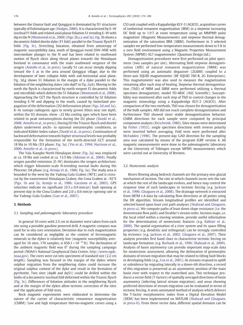
Rock powder samples from 11 sites, two from Nagarze and 9 fromQonggyai were analysed for susceptibility versus temperature. Low-temperature curves down to−196 °C show temperature dependencefollowing the Curie Law (Nagata, 1961) below −100 °C, indicatingsmall contribution of paramagnetic minerals to the total magneticsusceptibility signal. Low-temperature curves down to 5 K carried outin the MPMS did not show Morin transition of hematite at ~260 K,Verwey transition of magnetite at ~120 K, or pyrrhotite transition at30–34 K (Rochette et al., 1990; Fig. 4a). High-temperature curvesindicate that magnetic susceptibility is predominantly controlled bythe existence of pyrrhotite pointed out by a Hopkinson peak followedby a marked drop of susceptibility around the Curie temperature ofpyrrhotite at ca. 325 °C (Fig. 4b, dq47 and dn5). At higher temperatureof N400 °C a rise in magnetic susceptibility indicates the new for-mation of magnetite due to heating. Some samples indicate also acontribution of initial magnetite indicated by a decay of susceptibilityaround the Curie temperature of magnetite ca. 580 °C (Fig. 4b, dq42).
IRM starts to saturate from 300 to 500 mT until 1 T whensaturation is almost reached (Fig. 4c). Such saturation fields areclearly higher than expected for magnetite (max. 300 mT) and typicalfor pyrrhotite. Thermal demagnetization of SIRM is mainly achievedaround the Curie temperature of pyrrhotite (325 °C) in all the studiedsamples and afterwards a minor decay at around 580 °C indicates asmall contribution of magnetite (Fig. 4d).
Fig. 4. Rock magnetism experiments. a) MPMS low-temperature curves. b) high-temperatud) thermal demagnetization of SIRM (pyrrhotite unblocking indicated).
These results confirm the existence of pyrrhotite as themajor ferro(i)magnetic phase in the studied dykes. Surprisingly despite the clearexistence of pyrrhotite in e.g. high-temperature curves and thermaldemagnetization of SIRM there is no low temperature transitionobserved at 30–34 K in the MPMS analyses. Occurrence of pyrrhotiteas a remanence carrier within the Tethyan Himalaya has been widelydemonstrated in low-grade metacarbonates of the western andcentral Himalaya providing stable and meaningful remanence direc-tions (Rochette et al., 1990; Appel et al., 1995; Schill et al., 2004).
Measuredmagnetic susceptibility after each step of heating duringthermal demagnetization indicates no significant changes of themagnetic susceptibility below the Curie temperature of pyrrhotite.Some of the samples exhibit an increase of the magnetic susceptibilityabove 400 °C, likely indicating the transformation of the initialpyrrhotite and pyrite into magnetite as previously pointed out byCrouzet et al. (2001).
4.2. Remanence directions
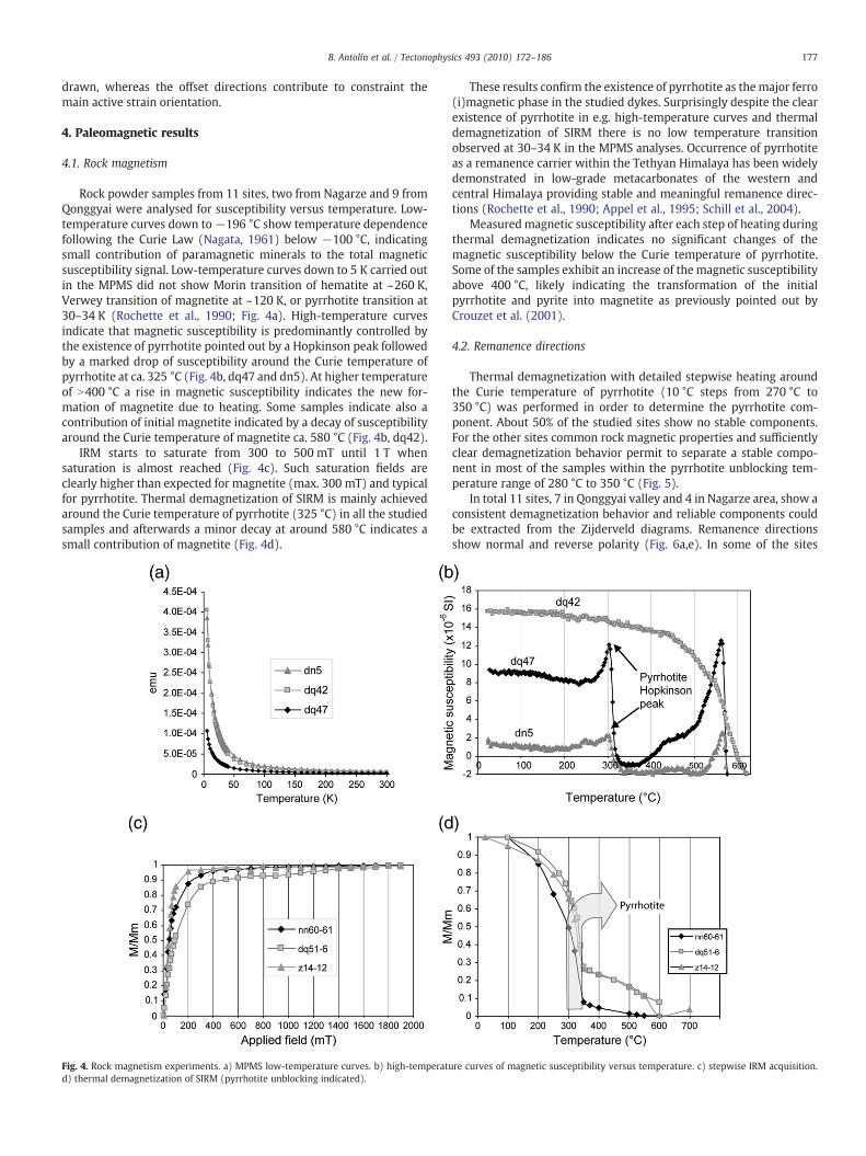
Thermal demagnetization with detailed stepwise heating aroundthe Curie temperature of pyrrhotite (10 °C steps from 270 °C to350 °C) was performed in order to determine the pyrrhotite com-ponent. About 50% of the studied sites show no stable components.For the other sites common rock magnetic properties and sufficientlyclear demagnetization behavior permit to separate a stable compo-nent in most of the samples within the pyrrhotite unblocking tem-perature range of 280 °C to 350 °C (Fig. 5).
In total 11 sites, 7 in Qonggyai valley and 4 in Nagarze area, show aconsistent demagnetization behavior and reliable components couldbe extracted from the Zijderveld diagrams. Remanence directionsshow normal and reverse polarity (Fig. 6a,e). In some of the sites
re curves of magnetic susceptibility versus temperature. c) stepwise IRM acquisition.
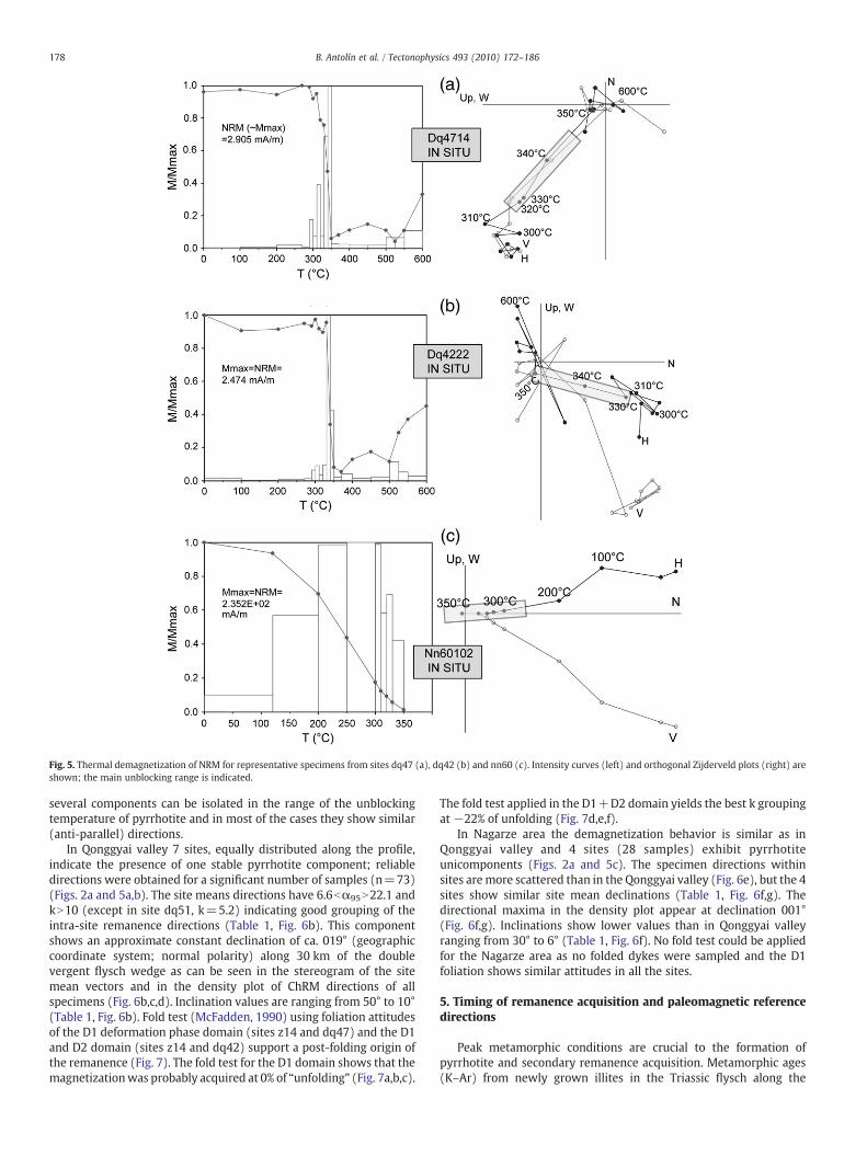
Fig. 5. Thermal demagnetization of NRM for representative specimens from sites dq47 (a), dq42 (b) and nn60 (c). Intensity curves (left) and orthogonal Zijderveld plots (right) areshown; the main unblocking range is indicated.
178 B. Antolín et al. / Tectonophysics 493 (2010) 172–186
several components can be isolated in the range of the unblockingtemperature of pyrrhotite and in most of the cases they show similar(anti-parallel) directions.
In Qonggyai valley 7 sites, equally distributed along the profile,indicate the presence of one stable pyrrhotite component; reliabledirections were obtained for a significant number of samples (n=73)(Figs. 2a and 5a,b). The site means directions have 6.6bα95N22.1 andkN10 (except in site dq51, k=5.2) indicating good grouping of theintra-site remanence directions (Table 1, Fig. 6b). This componentshows an approximate constant declination of ca. 019° (geographiccoordinate system; normal polarity) along 30 km of the doublevergent flysch wedge as can be seen in the stereogram of the sitemean vectors and in the density plot of ChRM directions of allspecimens (Fig. 6b,c,d). Inclination values are ranging from 50° to 10°(Table 1, Fig. 6b). Fold test (McFadden, 1990) using foliation attitudesof the D1 deformation phase domain (sites z14 and dq47) and the D1and D2 domain (sites z14 and dq42) support a post-folding origin ofthe remanence (Fig. 7). The fold test for the D1 domain shows that themagnetizationwas probably acquired at 0% of “unfolding” (Fig. 7a,b,c).
The fold test applied in the D1+D2 domain yields the best k groupingat −22% of unfolding (Fig. 7d,e,f).
In Nagarze area the demagnetization behavior is similar as inQonggyai valley and 4 sites (28 samples) exhibit pyrrhotiteunicomponents (Figs. 2a and 5c). The specimen directions withinsites aremore scattered than in the Qonggyai valley (Fig. 6e), but the 4sites show similar site mean declinations (Table 1, Fig. 6f,g). Thedirectional maxima in the density plot appear at declination 001°(Fig. 6f,g). Inclinations show lower values than in Qonggyai valleyranging from 30° to 6° (Table 1, Fig. 6f). No fold test could be appliedfor the Nagarze area as no folded dykes were sampled and the D1foliation shows similar attitudes in all the sites.
5. Timing of remanence acquisition and paleomagnetic referencedirections
Peak metamorphic conditions are crucial to the formation ofpyrrhotite and secondary remanence acquisition. Metamorphic ages(K–Ar) from newly grown illites in the Triassic flysch along the
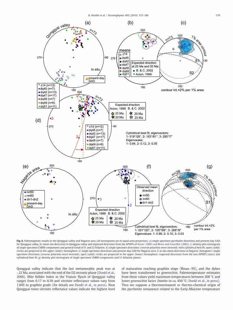
Fig. 6. Paleomagnetic results in the Qonggyai valley and Nagarze area (all stereograms are in equal-area projection). a) single specimen pyrrhotite directions and present-day GADfor Qonggyai valley. b) mean site directions in Qonggyai valley and expected directions from the APWPs of Acton (1999) and Besse and Courtillot (2002). c) density plot stereogramof single specimen ChRM components and general trend of S1 and S2 foliation. d) single specimen directions (reverse polarities were inverted) with cylindrical best fit; open (solid)circles are projected in the upper (lower) hemisphere. e) single specimen directions and present-day GAD for Nagarze area. f) in situ mean directions in Nagarze (hexagons); singlespecimen directions (reverse polarities were inverted), open (solid) circles are projected in the upper (lower) hemisphere; expected directions from the two APWPs (stars) andcylindrical best fit. g) density plot stereogram of single specimen ChRM components and S1 foliation planes.
179B. Antolín et al. / Tectonophysics 493 (2010) 172–186
Qonggyai valley indicate that the last metamorphic peak was at~22 Ma, associatedwith the end of the D2 tectonic phase (Dunkl et al.,2008). Illite Kübler Index in the Triassic flysch of Qonggyai valleyranges from 0.17 to 0.39 and vitrinite reflectance values vary from1.84% to graphite grade (for details see Dunkl et al., in press). NearQonggyai town vitrinite reflectance values indicate the highest level
of maturation reaching graphite stage (Rmax~9%), and the dykeshave been transformed to greenschist. Paleotemperature estimatesfrom these values yield maximum temperatures between 200 °C andlower greenschist facies (biotite-in ca. 450 °C; Dunkl et al., in press).Thus we suppose a thermoremanent or thermo-chemical origin ofthe pyrrhotite remanence related to the Early-Miocene temperature
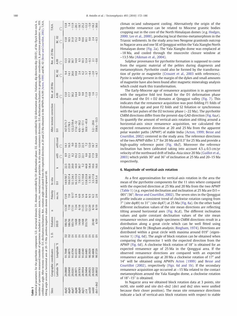
Table1
Statisticalp
aram
etersforthepy
rrho
tite
compo
nent.S
.D,struc
turald
omain;
D1,
domainco
ntrolle
dby
D1de
form
ationph
ase;
D2,
domainco
ntrolle
dby
D2de
form
ationph
ase.
Folia
tion
,dip
direction/dip(D
D/D
),of
theflysch
host-roc
k.n,
numbe
rof
specim
ensmea
sured/nu
mbe
rof
specim
ensinclud
edin
statistics.n
orm./rev
.,no
rmal/rev
erse
polarities.Insitu
mea
nreman
ence
directions
:D/I,d
eclin
ation/inclinationin
geog
raph
icco
ordina
tes;
k,precisionpa
rameter;α95,9
5%co
nfide
ncean
gle.After
tecton
icco
rrection
:D/I,d
eclin
ation/inclination.
Rot.,
rotation
anglecalculated
from
theex
pected
directionat
20an
d25
Maob
tained
intheAPW
Psof
A.99(A
cton
,199
9)an
dBC
.02(B
esse
andCo
urtillo
t,20
02).T.H.A,
tiltingan
glearou
ndaho
rizo
ntal
axis
at20
–15
Ma;
positive
/neg
ativeva
lues
deno
tedo
wnw
ard/up
wardtilt.
Sites
Geo
grap
hicco
ordina
tes
S.D.
Folia
tion
nPo
larity
Insitu
After
tecton
icco
rrection
Rot.at
20Ma
Rot.at
25Ma
T.H.A.
Latitude
°NLo
ngitud
e°E
DD/D
no./re.
D/I
kα95
α95
/cosI
D/I
A.99
BC.0
2A.99
BC.0
2(°)
(°)
(°)
(°)
(°)
(°)
(°)
dq42
29.086
091
.704
8D2
186/56
13/20
13/0
14.9/50.7
22.5
8.9
14.1
167.9/71
.713
.09.4
13.5
13.8
13.8
dq45
29.045
091
.687
5D2
186/56
7/18
7/0
19.6/37.4
22.0
13.1
16.5
117/78
.517
.714
.118
.218
.51.4
dq47
29.026
191
.670
4D1
183/79
17/31
0/17
32.1/24.1
20.0
8.2
9.0
122.2/59
.430
.226
.630
.731
.0−11
.9dq
4828
.997
191
.633
5D1
14/68
7/24
3/4
16.3/15.9
10.9
19.2
19.9
17.6/−
5214
.410
.814
.915
.2−20
.1dq
4928
.978
391
.606
8D1
14/68
6/18
6/0
7.9/17
.330
.712
.312
.94.9/−50
.26.0
2.4
6.5
6.8
−18
.7dq
5128
.995
491
.634
0D1
14/68
11/25
5/6
11.7/10.8
5.2
22.1
22.5
9.8/−57
.19.8
6.2
10.3
10.6
−25
.2z1
428
.949
491
.648
5D1
353/70
12/12
8/4
13.8/23.8
44.8
6.6
7.2
18.9/−
41.8
11.9
5.7
12.4
10.1
−12
.2nn
5029
.092
590
.392
9D1
12/20
9/3
1.1/30
.118
.410
.412
.0−0.8
−4.4
−0.3
0.0
−5.9
nn60
28.920
290
.480
8D1
20/40
8/16
6/2
3.5/17
.810
.617
.918
.73.2/−20
.61.6
−2.0
2.1
2.4
−18
.2dn
1+dn
228
.883
290
.372
9D1
4/59
8/19
2/6
0.8/5.4
16.6
14.0
14.1
358.6/−53
.5−1.1
−4.7
−0.6
−0.3
−30
.6
180 B. Antolín et al. / Tectonophysics 493 (2010) 172–186
climax or/and subsequent cooling. Alternatively the origin of thepyrrhotite remanence can be related to Miocene granitic bodiescropping out in the core of the North Himalayan domes (e.g. Hodges,2000; Lee et al., 2000), producing local thermo-metamorphism in theTriassic sediments. In the study area two Neogene granitoids outcropin Nagarze area and one SE of Qonggyai within the Yala Xiangbo NorthHimalayan dome (Fig. 2a). The Yala Xiangbo dome was emplaced at~18 Ma, and cooled through the muscovite closure window at~13.5 Ma (Aikman et al., 2004).
Sulphur provenance for pyrrhotite formation is supposed to comefrom the organic material of the pelites during diagenesis andmetamorphism. Pyrrhotite could also be formed by the transforma-tion of pyrite or magnetite (Crouzet et al., 2003 with references).Pyrite is widely present in the margin of the dykes and small amountsof magnetite have also been found after magnetic mineralogy analysiswhich could mark this transformation.
The Early-Miocene age of remanence acquisition is in agreementwith the negative fold test found for the D1 deformation phasedomain and the D1+D2 domains at Qonggyai valley (Fig. 7). Thisindicates that the remanence acquisition was post-folding F1 folds ofEohimalayan age and post F2 folds and S2 foliation or synchronouswith the last pulses of the D2 tectonic phase (~22 Ma). The pyrrhotiteChRM directions differ from the present-day GAD direction (Fig. 6a,e).To quantify the amount of vertical-axis rotation and tilting around ahorizontal-axis since remanence acquisition, we calculated theexpected remanence direction at 20 and 25 Ma from the apparentpolar wander paths (APWP) of stable India (Acton, 1999; Besse andCourtillot, 2002) centered in the study area. The reference directionsof the two APWP differ 3.7° for 20 Ma and 0.3° for 25 Ma and provide ahigh-quality reference point (Fig. 6b,f). Moreover the referenceinclination has been calibrated taking into account 4.5±0.5 cm/yrvelocity of the northward drift of India–Asia since 20 Ma (Guillot et al.,2003) which yields 30° and 36° of inclination at 25 Ma and 20–15 Marespectively.
6. Magnitude of vertical-axis rotation
As a first approximation for vertical-axis rotation in the area themean of the pyrrhotite components for the 11 sites where comparedwith the expected direction at 25 Ma and 20 Ma from the two APWP(Table 1) (e.g. expected declination and inclination at 25 Ma are D/I=001°/36°; Besse and Courtillot, 2002). The seven sites in the Qonggyaiprofile indicate a consistent trend of clockwise rotation ranging from7° (site dq49) to 31° (site dq47) at 25 Ma (Fig. 8a). On the other handdifferent inclination values of the site mean directions are reflectingtilting around horizontal axes (Fig. 8c,d). The different inclinationvalues and quite constant declination values of the site meanremanence vectors and single specimens ChRM directions result in adistribution along a great circle which can be well fitted usingcylindrical best fit (Bingham analysis; Bingham, 1974). Directions aredistributed within a great circle with maxima around 019° (eigen-vector 1) (Fig. 6d). The angle of block rotation can be obtained whencomparing the eigenvector 1 with the expected direction from theAPWP (Fig. 6d). A clockwise block rotation of 18° is obtained for anexpected remanence age of 25 Ma in the Qonggyai area. If theobserved remanence directions are compared with an expectedremanence acquisition age at 20 Ma a clockwise rotation of 17° and14° will be obtained using APWPs Acton (1999) and Besse andCourtillot (2002), respectively (Figs. 6d and 1b). If the secondaryremanence acquisition age occurred at ~15 Ma related to the contactmetamorphism around the Yala Xiangbo dome, a clockwise rotationof 18°–15° is obtained.
In Nagarze area we obtained block rotation data at 3 points, sitenn50, site nn60 and site dn1–dn2 (dn1 and dn2 sites were unifiedbecause their closer position). The mean site remanence directionsindicate a lack of vertical-axis block rotations with respect to stable
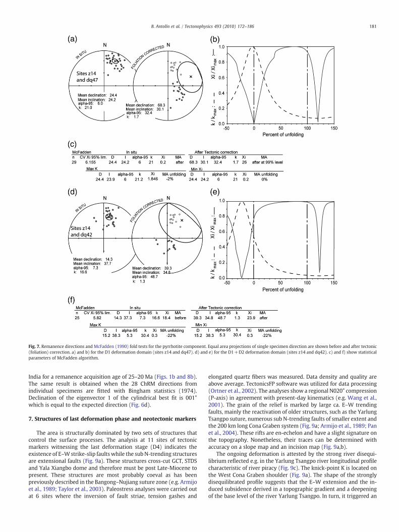
Fig. 7. Remanence directions and McFadden (1990) fold tests for the pyrrhotite component. Equal area projections of single specimen direction are shown before and after tectonic(foliation) correction. a) and b) for the D1 deformation domain (sites z14 and dq47). d) and e) for the D1+D2 deformation domain (sites z14 and dq42). c) and f) show statisticalparameters of McFadden algorithm.
181B. Antolín et al. / Tectonophysics 493 (2010) 172–186
India for a remanence acquisition age of 25–20 Ma (Figs. 1b and 8b).The same result is obtained when the 28 ChRM directions fromindividual specimens are fitted with Bingham statistics (1974).Declination of the eigenvector 1 of the cylindrical best fit is 001°which is equal to the expected direction (Fig. 6d).
7. Structures of last deformation phase and neotectonic markers
The area is structurally dominated by two sets of structures thatcontrol the surface processes. The analysis at 11 sites of tectonicmarkers witnessing the last deformation stage (D4) indicates theexistence of E–Wstrike-slip faults while the sub N-trending structuresare extensional faults (Fig. 9a). These structures cross-cut GCT, STDSand Yala Xiangbo dome and therefore must be post Late-Miocene topresent. These structures are most probably coeval as has beenpreviously described in the Bangong–Nujiang suture zone (e.g. Armijoet al., 1989; Taylor et al., 2003). Paleostress analyses were carried outat 6 sites where the inversion of fault striae, tension gashes and
elongated quartz fibers was measured. Data density and quality areabove average. TectonicsFP software was utilized for data processing(Ortner et al., 2002). The analyses show a regional N020° compression(P-axis) in agreement with present-day kinematics (e.g. Wang et al.,2001). The grain of the relief is marked by large ca. E–W trendingfaults, mainly the reactivation of older structures, such as the YarlungTsangpo suture, numerous sub N-trending faults of smaller extent andthe 200 km long Cona Graben system (Fig. 9a; Armijo et al., 1989; Panet al., 2004). These rifts are en-echelon and have a slight signature onthe topography. Nonetheless, their traces can be determined withaccuracy on a slope map and an incision map (Fig. 9a,b).
The ongoing deformation is attested by the strong river disequi-librium reflected e.g. in the Yarlung Tsangpo river longitudinal profilecharacteristic of river piracy (Fig. 9c). The knick-point K is located onthe West Cona Graben shoulder (Fig. 9a). The shape of the stronglydisequilibrated profile suggests that the E–W extension and the in-duced subsidence derived in a topographic gradient and a deepeningof the base level of the river Yarlung Tsangpo. In turn, it triggered an
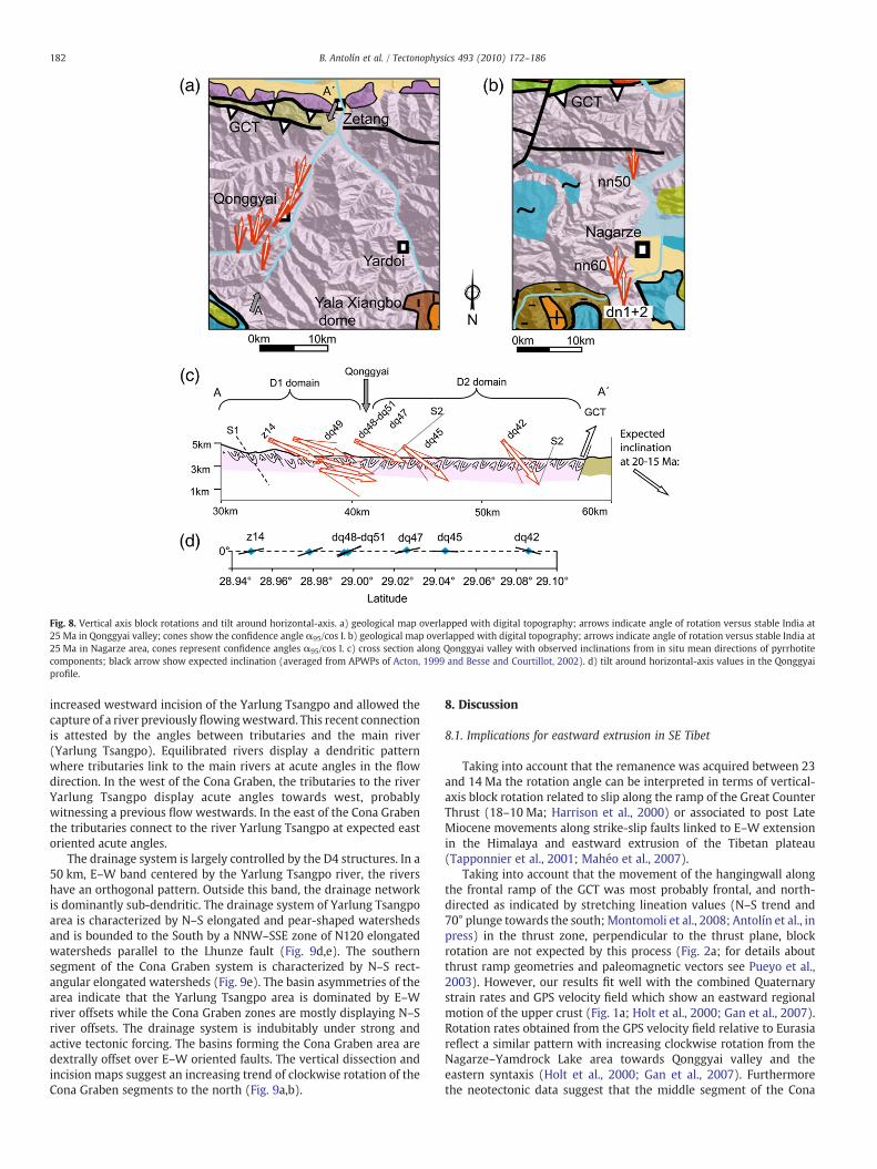
Fig. 8. Vertical axis block rotations and tilt around horizontal-axis. a) geological map overlapped with digital topography; arrows indicate angle of rotation versus stable India at25 Ma in Qonggyai valley; cones show the confidence angle α95/cos I. b) geological map overlapped with digital topography; arrows indicate angle of rotation versus stable India at25 Ma in Nagarze area, cones represent confidence angles α95/cos I. c) cross section along Qonggyai valley with observed inclinations from in situ mean directions of pyrrhotitecomponents; black arrow show expected inclination (averaged from APWPs of Acton, 1999 and Besse and Courtillot, 2002). d) tilt around horizontal-axis values in the Qonggyaiprofile.
182 B. Antolín et al. / Tectonophysics 493 (2010) 172–186
increased westward incision of the Yarlung Tsangpo and allowed thecapture of a river previously flowingwestward. This recent connectionis attested by the angles between tributaries and the main river(Yarlung Tsangpo). Equilibrated rivers display a dendritic patternwhere tributaries link to the main rivers at acute angles in the flowdirection. In the west of the Cona Graben, the tributaries to the riverYarlung Tsangpo display acute angles towards west, probablywitnessing a previous flow westwards. In the east of the Cona Grabenthe tributaries connect to the river Yarlung Tsangpo at expected eastoriented acute angles.
The drainage system is largely controlled by the D4 structures. In a50 km, E–W band centered by the Yarlung Tsangpo river, the rivershave an orthogonal pattern. Outside this band, the drainage networkis dominantly sub-dendritic. The drainage system of Yarlung Tsangpoarea is characterized by N–S elongated and pear-shaped watershedsand is bounded to the South by a NNW–SSE zone of N120 elongatedwatersheds parallel to the Lhunze fault (Fig. 9d,e). The southernsegment of the Cona Graben system is characterized by N–S rect-angular elongated watersheds (Fig. 9e). The basin asymmetries of thearea indicate that the Yarlung Tsangpo area is dominated by E–Wriver offsets while the Cona Graben zones are mostly displaying N–Sriver offsets. The drainage system is indubitably under strong andactive tectonic forcing. The basins forming the Cona Graben area aredextrally offset over E–W oriented faults. The vertical dissection andincision maps suggest an increasing trend of clockwise rotation of theCona Graben segments to the north (Fig. 9a,b).
8. Discussion
8.1. Implications for eastward extrusion in SE Tibet
Taking into account that the remanence was acquired between 23and 14 Ma the rotation angle can be interpreted in terms of vertical-axis block rotation related to slip along the ramp of the Great CounterThrust (18–10 Ma; Harrison et al., 2000) or associated to post LateMiocene movements along strike-slip faults linked to E–W extensionin the Himalaya and eastward extrusion of the Tibetan plateau(Tapponnier et al., 2001; Mahéo et al., 2007).
Taking into account that the movement of the hangingwall alongthe frontal ramp of the GCT was most probably frontal, and north-directed as indicated by stretching lineation values (N–S trend and70° plunge towards the south; Montomoli et al., 2008; Antolín et al., inpress) in the thrust zone, perpendicular to the thrust plane, blockrotation are not expected by this process (Fig. 2a; for details aboutthrust ramp geometries and paleomagnetic vectors see Pueyo et al.,2003). However, our results fit well with the combined Quaternarystrain rates and GPS velocity field which show an eastward regionalmotion of the upper crust (Fig. 1a; Holt et al., 2000; Gan et al., 2007).Rotation rates obtained from the GPS velocity field relative to Eurasiareflect a similar pattern with increasing clockwise rotation from theNagarze–Yamdrock Lake area towards Qonggyai valley and theeastern syntaxis (Holt et al., 2000; Gan et al., 2007). Furthermorethe neotectonic data suggest that the middle segment of the Cona
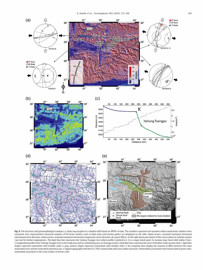
Fig. 9. D4 structures and geomorphological analysis. a) slope map draped on a shaded relief based on SRTM v.4 data. The numbers represent site locations where neotectonic markers weremeasured. Four representative structural analyses of D4 strain markers such as fault striae and tension gashes are displayed on the sides (black arrows: assumed maximum horizontalextensional stress direction,white arrows: assumedmaximumhorizontal compressive stress direction, qf: quartz fibers). In the right downpart sketch of the ConaGraben en-echelon system(see text for further explanations). The light blue line represents the Yarlung Tsangpo river which profile is plotted in C. K is a major knick-point. b) incision map (local relief within 3 km).c) longitudinal profile of theYarlungTsangpo river in thestudyarea and its contributingarea. d)drainage system(darkblue lines represent theriversof Strahler ordersgreater than1, lightblueshapes represent watersheds with Strahler order 2, gray contour shapes represent watersheds with Strahler order 3, the turquoise lines display the amount of offset between the mainwatershed rivers and thewatershedsymmetryaxis. e)digital topographywith theGCT, IYSZ, Lhunze fault andConaGraben structures.Watershedsassociated to theLhunze fault ingreencolor,watersheds associated to the Cona Graben in brown color.
183B. Antolín et al. / Tectonophysics 493 (2010) 172–186
184 B. Antolín et al. / Tectonophysics 493 (2010) 172–186
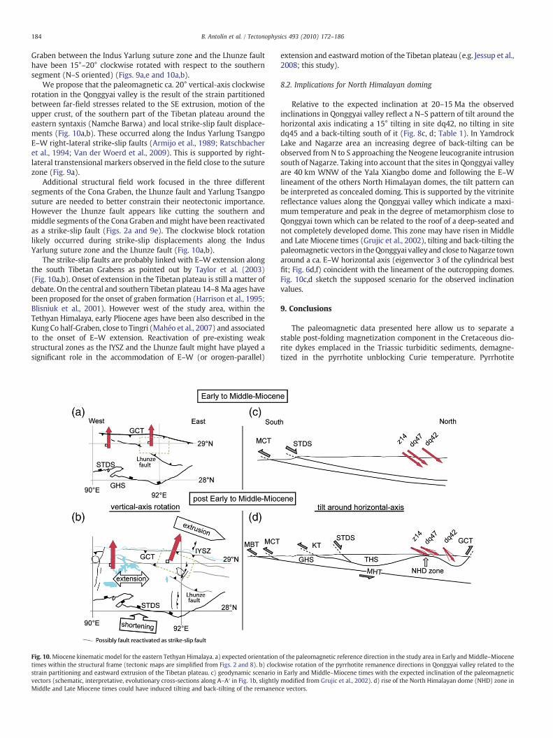
Graben between the Indus Yarlung suture zone and the Lhunze faulthave been 15°–20° clockwise rotated with respect to the southernsegment (N–S oriented) (Figs. 9a,e and 10a,b).
We propose that the paleomagnetic ca. 20° vertical-axis clockwiserotation in the Qonggyai valley is the result of the strain partitionedbetween far-field stresses related to the SE extrusion, motion of theupper crust, of the southern part of the Tibetan plateau around theeastern syntaxis (Namche Barwa) and local strike-slip fault displace-ments (Fig. 10a,b). These occurred along the Indus Yarlung TsangpoE–W right-lateral strike-slip faults (Armijo et al., 1989; Ratschbacheret al., 1994; Van der Woerd et al., 2009). This is supported by right-lateral transtensional markers observed in the field close to the suturezone (Fig. 9a).
Additional structural field work focused in the three differentsegments of the Cona Graben, the Lhunze fault and Yarlung Tsangposuture are needed to better constrain their neotectonic importance.However the Lhunze fault appears like cutting the southern andmiddle segments of the Cona Graben andmight have been reactivatedas a strike-slip fault (Figs. 2a and 9e). The clockwise block rotationlikely occurred during strike-slip displacements along the IndusYarlung suture zone and the Lhunze fault (Fig. 10a,b).
The strike-slip faults are probably linked with E–W extension alongthe south Tibetan Grabens as pointed out by Taylor et al. (2003)(Fig. 10a,b). Onset of extension in the Tibetan plateau is still a matter ofdebate. On the central and southern Tibetan plateau 14–8 Ma ages havebeen proposed for the onset of graben formation (Harrison et al., 1995;Blisniuk et al., 2001). However west of the study area, within theTethyan Himalaya, early Pliocene ages have been also described in theKung Co half-Graben, close to Tingri (Mahéo et al., 2007) and associatedto the onset of E–W extension. Reactivation of pre-existing weakstructural zones as the IYSZ and the Lhunze fault might have played asignificant role in the accommodation of E–W (or orogen-parallel)
Fig. 10.Miocene kinematic model for the eastern Tethyan Himalaya. a) expected orientationtimes within the structural frame (tectonic maps are simplified from Figs. 2 and 8). b) clockstrain partitioning and eastward extrusion of the Tibetan plateau. c) geodynamic scenario ivectors (schematic, interpretative, evolutionary cross-sections along A–A′ in Fig. 1b, slightlyMiddle and Late Miocene times could have induced tilting and back-tilting of the remanen
extension and eastwardmotion of the Tibetan plateau (e.g. Jessup et al.,2008; this study).
8.2. Implications for North Himalayan doming
Relative to the expected inclination at 20–15 Ma the observedinclinations in Qonggyai valley reflect a N–S pattern of tilt around thehorizontal axis indicating a 15° tilting in site dq42, no tilting in sitedq45 and a back-tilting south of it (Fig. 8c, d; Table 1). In YamdrockLake and Nagarze area an increasing degree of back-tilting can beobserved from N to S approaching the Neogene leucogranite intrusionsouth of Nagarze. Taking into account that the sites in Qonggyai valleyare 40 km WNW of the Yala Xiangbo dome and following the E–Wlineament of the others North Himalayan domes, the tilt pattern canbe interpreted as concealed doming. This is supported by the vitrinitereflectance values along the Qonggyai valley which indicate a maxi-mum temperature and peak in the degree of metamorphism close toQonggyai town which can be related to the roof of a deep-seated andnot completely developed dome. This zone may have risen in Middleand Late Miocene times (Grujic et al., 2002), tilting and back-tilting thepaleomagnetic vectors in theQonggyai valley and close toNagarze townaround a ca. E–W horizontal axis (eigenvector 3 of the cylindrical bestfit; Fig. 6d,f) coincident with the lineament of the outcropping domes.Fig. 10c,d sketch the supposed scenario for the observed inclinationvalues.
9. Conclusions
The paleomagnetic data presented here allow us to separate astable post-folding magnetization component in the Cretaceous dio-rite dykes emplaced in the Triassic turbiditic sediments, demagne-tized in the pyrrhotite unblocking Curie temperature. Pyrrhotite
of the paleomagnetic reference direction in the study area in Early andMiddle–Miocenewise rotation of the pyrrhotite remanence directions in Qonggyai valley related to then Early and Middle–Miocene times with the expected inclination of the paleomagneticmodified from Grujic et al., 2002). d) rise of the North Himalayan dome (NHD) zone ince vectors.
185B. Antolín et al. / Tectonophysics 493 (2010) 172–186
occurrence is supported by a Hopkinson peak and decay at 325 °C inhigh-temperature susceptibility curves, SIRM saturation field valuesN300mT, and a sharp decrease of remanent magnetization at ~325 °Cduring thermal demagnetization of the SIRM. A small contribution ofmagnetite is additionally present. The secondary character of theChRM can be asserted by two facts: (i) Negative fold test for foliationattitudes of the D1 deformation phase domain and the D1+D2domain in the Qonggyai valley. (ii) Thermochronological data in theTriassic flysch indicating that a peak metamorphism above the Curietemperature of pyrrhotite was reached for the last time between22 Ma and 14 Ma at the end of D2 tectonic phase (Aikman et al., 2004;Dunkl et al., 2008). Therefore themagnetization is of thermoremanentor thermo-chemical origin and can be evaluated as a record of theEarly Miocene field.
Remanence vectors from Nagarze–Yamdrock Lake area andQonggyai valley indicate a transition from no rotation in the west to~20° clockwise rotation in the east against stable India since Early toMiddle-Miocene. This rotation can be explained by the strong strainpartitioning between far-field eastward extrusion and near-fieldstrike-slip faulting and E–W extension reflected in the en-echelonCona Graben system, the drainage system and the watersheds shapeand distribution. At regional scale our results represent a field supportfor the clockwise rotation of the southeastern corner of the Tibetanplateau around the eastern syntaxis during the eastward extrusion, ormotion of the upper crust, of the Tibetan plateau (Armijo et al., 1989;Royden et al., 1997; Tapponnier et al., 2001). However, more paleo-magnetic and structural studies east of the Cona Graben should bedone to verify this interpretation.
Tilting and back-tilting of the paleomagnetic remanence vectorsaround a horizontal-axis may reflect the rising of the North Himalayandome zone in Middle Miocene times.
Acknowledgements
The authors are grateful for the aid during fieldwork to Tawa. Wethank G. Ojha, P. Branscheid and L. Bello for assistance during thepaleomagnetic measurements, and T. Frederichs for providing MPMSanalysis. For standard paleomagnetic processing the Palmag softwarev.3.2 of Maier and Bachtadse and Stereonet for Windows v.1.2 ofAllmendinger (2002–2003) were used. This research was supportedby the German Science Foundation (DFG) in the frame of the PriorityProgramme 1372 “Tibetan Plateau: Formation, Climate, Ecosystems(TiP)” and by grants from the Chinese NSF (40625008 to Ding), CAS(KZCX2-YW-Q09-03 to Ding), and National Basic Research Program ofChina (2009CB421000 to Ding). We acknowledge the revision fromtwo anonymous reviewers and the editor F. Storti who helpedimprove the first version of the manuscript.
References
Acton, G.D., 1999. Apparent polar wander of India since the Cretaceous with implicationsfor regional tectonics and true polar wander. In: Radhakrishna, T., Piper, J.D.A. (Eds.),The Indian subcontinent and Gondwana; a paleomagnetic and rock magnetic per-spective: Memoir-Geological Society of India, 44, pp. 129–175.
Aikman, A., Harrison, T.M., Lin, D., 2004. Preliminary results from the Yala-XiangboLeucogranite dome, SE Tibet. 19th Himalaya–Karakoram–Tibet workshop extendedabstracts. Himalayan J. Sci. 2, 91.
Aikman, A., Harrison, T.M., Ding, L., 2008. Evidence for Early (N44 Ma) HimalayanCrustal Thickening, Tethyan Himalaya, southeastern Tibet. Earth Planet. Sci. Lett.274, 14–23.
Antolín, B., Appel, E., Montomoli, C., Dunkl, I., Ding, L., Gloaguen R., El Bay, R. in press.Kinematic evolution of the eastern Tethyan Himalaya: Constraints from magneticfabric and structural properties of the Triassic flysch in SE Tibet. In: J. Poblet and R.Lisle, Editors, Kinematic Evolution and Structural Styles of Fold-and-Thrust Belts,Geol. Soc. London Spec. Publ.
Ali, J.R., Aitchison, J.C., 2005. Greater India. Earth Sci. Rev. 72, 169–188.Appel, E., Patzelt, A., Chouker, C., 1995. Secondary paleoremanence of Tethyan sedi-
ments from the Zanskar Range (NW Himalaya). Geophys. J. Int. 122, 227–242.
Armijo, R., Tapponnier, P., Mercier, J.L., Tonglin, H., 1986. Quaternary extension insouthern Tibet: field observations and tectonic implications. J. Geophys. Res. 91(nB14), 13803–13872.
Armijo, R., Tapponnier, P., Tonglin, H., 1989. Late Cenozoic right-lateral strike-slipfaulting in Southern Tibet. J. Geophys. Res. 94, 2787–2838.
Besse, J., Courtillot, V., 2002. Apparent and true polar wander and the geometry ofthe geomagnetic field over the last 200 Myr. J. Geophys. Res. 107 (B11), 2300.doi:10.1029/2000jb000050.
Bingham, C., 1974. An antipodally symmetric distribution on the sphere. Ann. Stat. 2,1201–1225.
Blisniuk, P.M., Hacker, B.R., Glodny, J., Ratschbacher, L., Bi, S., Wu, Z., McWilliams, M.O.,Calvert, A., 2001. Extension in central Tibet since at least 13.5 Myr. Nature 412,628–632.
Burbank, D., Meigs, A., Brozovi, N., 1996. Interactions of growing folds and coevaldepositional Systems. Basin Res. 8, 199–223.
Burchfiel, B., Zhiliang, C., Hodges, K.V., Yuping, L., Royden, L.H., Changrong, D., Jiene, X.,1992. The South Tibetan detachment system, Himalaya orogen: extensioncontemporaneous with and parallel to shortening in a collisional mountain belt.Geol. Soc. Am. Spec. Pap. 269, 1–41.
Burg, J.P., Chen, G.M., 1984. Tectonics and structural zonation of southern Tibet, China.Nature 311, 219–223.
Carosi, R., Lombardo, B., Molli, G., Musumeci, G., Pertusati, P., 1998. The South TibetanDetachment system in the Rongbuck valley, Everest region. Deformation featuresand geological implications. J. Asian Earth Sci. 16, 299–311.
Carosi, R., Montomoli, C., Visonà, D., 2002. Is there any detachment in the Lower Dolpo(western Nepal)? C.R. Geosci. 334, 933–940.
Cox, R.T., Van Arsdale, R.B., Harris, J.B., 2001. Identification of possible Quaternary defor-mation in the northeastern Mississippi Embayment using quantitative geomorphicanalysis of drainage-basin asymmetry. Geol. Soc. Am. Bull. 113, 615–624.
Crouzet, C., Stang, H., Appel, E., Schill, E., Gautam, P., 2001. Detailed analysis of suc-cessive pTRMs carried by pyrrhotite in Himalayan metacarbonates: an examplefrom Hidden Valley Central Nepal. Geophys. J. Int. 146, 607–618.
Crouzet, C., Gautam, P., Schill, E., Appel, E., 2003. Multicomponent magnetization inWestern Dolpo (Tethyan Himalaya, Nepal): implications for tectonic motions.Tectonophysics 377, 179–196.
Ding, L., Kapp, P., Wan, X., 2005. Paleocene–Eocene record of ophiolite obduction andinitial India–Asia collision, south central Tibet. Tectonics 24, TC3001. doi:10.1029/2004TC001729.
Dunkl, I., Lin, D., Montomoli, C., Wemmer, K., Rantisch, G., Antolín, B., El Bay, R., Appel,E., 2008. Diagenetic andmetamorphic overprint and deformation history of Permo-Triassic Tethyan sediments, SE Tibet. 23th Himalaya–Karakoram–Tibet workshopextended abstracts. Himalayan J. Sci. 5, 49.
Dunkl, I., Antolín, B., Wemmer, K., Rantitsch, G., Kienast, M., Montomoli, C., Ding, L.,Carosi, R., Appel, E., El Bay, R., Xu, Q. and von Eynatten, H., in press. Metamorphicevolution of the Tethyan Himalayan flysch in SE Tibet. In: R. Gloaguen and L.Ratschbacher, Editors, Growth and Collapse of the Tibetan Plateau, Geol. Soc.London Spec. Publ.
Dupuis, C., Hébert, R., Dubois-Coté, V., Guilmette, C., Wang, C.S., Li, Z.J., 2006.Geochemistry of sedimentary rocks from mélange and flysch units south of theYarlung Zangbo suture zone, southern Tibet. J. Asian Earth Sci. 26, 489–508.
Eldredge, S., Bachtadse, V., Van der Voo, R., 1985. Paleomagnetism and the oroclinehypothesis. Tectonophysics 119, 153–179.
Fisher, R.A., 1953. Dispersion on a sphere. Proc. R. Soc. London. 217, 295–305.Gaetani, M., Garzanti, E., 1991. Multicyclic history of the northern Indian continental
margin (northwestern Himalaya). AAPG Bull. 75, 1427–1446.Gan,W., Zhang, P., Shen, Z.-K., Niu, Z.,Wang,M.,Wan, Y., Zhou, D., Cheng, J., 2007. Present-
day crustal motion within the Tibetan Plateau inferred from GPS measurements.J. Geophys. Res. 112, B08416. doi:10.1029/2005JB004120.
Gansser, A., 1964. Geology of the Himalaya. Wiley-Interscience, New York. 289 pp.Garzione, C.N., DeCelles, P.G., Hodkinson, D.G., Ojha, T.P., Upreti, B.N., 2003. East–west
extension and Miocene environmental change in the southern Tibetan plateau:Thakkhola graben, central Nepal. Geol. Soc. Am. Bull. 115, 3–20.
Gloaguen, R., Marpu, P.R., Niemeyer, I., 2007. Automatic extraction of faults and fractalanalysis from remote sensing data. Nonlinear Processes Geophys. 14 (2), 131–138.
Gloaguen, R., Käßner, A., Wobbe, F., Shahzad, F., Mahmood, A., 2008. Remote sensinganalysis of crustal deformation using river networks. Geoscience and RemoteSensing Symposium. IGARSS 2008: IEEE International, 4, pp. 1–4.
Godin, L., 2003. Structural evolution of the Tethyan sedimentary sequence in theAnnapurna area, central Nepal Himalaya. J. Asian Earth Sci. 22, 307–328.
Godin, L., Grujic, D., Law, R.D., Searle, M.P., 2006. Channel flow, extrusion and ex-humation in continental collision zones: an introduction. In: Law, R.D., Searle, M.P.,Godin, L. (Eds.), Channel Flow, Ductile Extrusion and Exhumation in ContinentalCollision Zones: Geol. Soc. London Spec. Publ., 268, pp. 1–23.
Grujic, D., Hollister, L.S., Parrish, R.R., 2002. Himalayan metamorphic sequence as anorogenic channel: insight from Bhutan. Earth Planet. Sci. Lett. 198, 177–191.
Guillot, S., Garzanti, G., Baratoux, D., Marquer, D., Maheo, G., de Sigoyer, J., 2003. Recon-structing the total shortening history of the NW Himalaya. Geochem. Geophys.Geosyst. 4. doi:10.1029/2002GC000484.
Harrison, T.M., Copeland, P., Kidd, W.S.F., Lovera, O.M., 1995. Activation of the Nyainqen–tanghla shear zone: Implications for uplift of the southern Tibetan Plateau. Tectonics14, 658–676.
Harrison, T.M., Yin, A., Grove, M., Lovera, O.M., 2000. The Zedong Window: a record ofsuperposed Tertiary convergence in southeastern Tibet. J. Geophys. Res. 105,19211–19320.
Hodges, K.V., 2000. Tectonics of the Himalaya and southern Tibet from two perspectives.Geol. Soc. Am. Bull. 112, 324–350.
186 B. Antolín et al. / Tectonophysics 493 (2010) 172–186
Holt, W.E., Chamot-Rooke, N., Le Pichon, X., Haines, A.J., Shen-Tu, B., Ren, J., 2000.Velocity field in Asia inferred from Quaternary fault slip rates and GlobalPositioning System observations. J. Geophys. Res. 105, 19185–19209.
Jackson, J., Norris, R., Youngson, J., 1996. The structural evolution of fault and foldsystems in central Otago, New Zealand: evidence revealed by drainage patterns.J. Struct. Geol. 18, 217–234.
Jackson, J., Ritz, J.F., Siame, L., Raisbeck, G., Yiou, F., Norris, R.J., Youngson, J.H., Bennett,E., 2002. Fault growth and landscape development rates in Otago, New Zealand,using in situ cosmogenic 10Be. Earth Planet. Sci. Lett. 195, 185–193.
Jessup, M.J., Newell, D.L., Cottle, J.M., Berger, A.L., Spotila, J.A., 2008. Orogen-parallelextension and exhumation enhanced by focused denudation in the Arun Rivergorge, Ama Drime Massif, Tibet–Nepal. Geology 36, 587–590.
Käßner, A., Gloaguen, R., Stanek, K.-P., 2008. Remote sensing analysis of recent tectonicsin the Eger Rift (Czech Republic). International Geoscience and Remote SensingSymposium (IGARSS), pp. 1636–1639.
Kellett, D.A., Godin, L., 2009. Pre-Miocene deformation of the Himalayan superstruc-ture, Hidden valley, central Nepal. J. Geol. Soc. London 166, 261–275.
Kellett, D.A., Grujic, D., Erdmann, S., 2009. Miocene structural reorganization of theSouth Tibetan detachment, eastern Himalaya: implications for continental collision.Lithosphere 1 (5), 259–281.
Kirschvink, J.L., 1980. The least-squares line and plane and the analysis of palaeo-magnetic data. Geophys. J. R. Astron. Soc. 62, 699–718.
Klootwijk, C.T., Conaghan, P., Powell, C., 1985. The Himalayan Arc: large-scale con-tinental subduction, oroclinal bending and back-arc spreading. Earth Planet. Sci.Lett. 75, 167–183.
Leech, M.L., 2008. Does the Karakoram fault interrupt mid-crustal channel flow in thewestern Himalaya? Earth Planet. Sci. Lett. 276, 314–322.
Lee, J., Hacker, B.R., Dinklage, W.S., Wang, Y., Gans, P., Calvert, A., Wan, J.L., Chen, W.J.,Blythe, A.E., McClelland, W., 2000. Evolution of the Kangmar Dome, southern Tibet:structural, petrologic, and thermochronologic constraints. Tectonics 19, 872–895.
Li, D., Yin, A., 2008. Orogen-parallel, active left-slip faults in the Eastern Himalaya:implications for the growthmechanism of the Himalayan Arc. Earth Planet. Sci. Lett.274, 258–267.
Liebke, U., Appel, E., Neumann, U., Antolin, B., Ding, L, Xu, Q., in press. Position of theLhasa terrane prior to India–Asia collision derived from palaeomagnetic inclina-tions of 53 Ma old dykes of the Linzhou Basin: constraints on the age of collisionand post-collisional shortening within the Tibetan Plateau. Geophys. J. Int.doi:10.1111/j.1365-246X.2010.04698.x.
Liu, G., Einsele, G., 1994. Sedimentary history of the Tethyan basin in the TibetanHimalayas. Geol. Rundsch. 83, 32–61.
Maffione, M., Speranza, F., Faccenna, C., Rosello, E., 2009. Paleomagnetic evidence for apre-early Eocene ( 50 Ma) bending of the Patagonian orocline (Tierra del Fuego,Argentina): Paleogeographic and tectonic implications. Earth Planet. Sci. Lett.doi:10.1016/j.epsl.2009.11.015.
Mahéo, G., Leloup, P.H., Valli, F., Lacassin, R., Arnaud, N., Paquette, J.-L., Fernandez, A.,Haibing, L., Farley, K.A., Tapponnier, P., 2007. Post 4 Ma initiation of normal faultingin southern Tibet. Constraints from the Kung Co half graben. Earth Planet. Sci. Lett.256, 233–243.
McFadden, P.L., 1990. A new fold test for paleomagnetic studies. Geophys. J. Int. 103,163–169.
Montomoli, C., Appel, E., Antolín, B., Dunkl, I., El Bay, R., Lin, D., Gloaguen, R., 2008.Polyphase deformation history of the “Tibetan Sedimentary Sequence” in theHimalaya chain (South-East Tibet). 23th Himalaya–Karakoram–Tibet workshopextended abstracts. Himalayan J. Sci. 5, 91.
Nagata, T., 1961. Rock Magnetism, 2nd edition. Maruzen, Tokyo, p. 350.Oliva-Urcia, B., Pueyo, E.L., 2007. Rotational basement kinematics deduced from re-
magnetized cover rocks (Internal Sierras, southwestern Pyrenees). Tectonics 26,TC4014.
Ortner,H., Reiter, F., Acs, P., 2002. Easyhandling of tectonicdata: theprogramsTectonicVB forMac and TectonicsFP for Windows. Comput. Geosci. (28/10), 1193–1200. doi:10.1016/S0098-3004(02)00038-9.
Pan, G., Ding, J., Yao, D., Wang, L., 2004. Geological map of Qinghai–Xizang (Tibet) Plateauand Adjacent Areas (1:1,500,000). Chengdu Institute of Geology and MineralResources, China Geological Survey. Chengdu Cartographic Publishing House.
Pêcher, A., Bouchez, J.L., Le Fort, P., 1991. Miocene dextral shearing between Himalayaand Tibet. Geology 19, 683–685.
Pueyo, E.L., Pocoví, A., Parés, J.M., Millán, H., Larrasoaña, J.C., 2003. Thrust rampgeometry and spurious rotations of paleomagnetic vectors. Stud. Geophys. Geod.47, 331–357.
Ratschbacher, L., Frisch, W., Liu, G., Chen, C., 1994. Distributed deformation in southernand western Tibet during and after the India–Asia collision. J. Geophys. Res. SolidEarth 99, 19917–19945.
Rochette, P., Fillion, G., Mattéi, J.L., Dekkers, M.J., 1990. Magnetic transition at 30–34Kelvin in pyrrhotite: insight into widespread occurrence of this mineral in rocks.Earth Planet. Sci. Lett. 98, 319–328.
Royden, L.H., Burchfiel, B.H., King, R.W., Wang, E., Chen, Z., Shen, F., Liu, Y., 1997. Surfacedeformation and lower crustal flow in Eastern Tibet. Science 276, 788–790.
Schill, E., Appel, E., Zeh, O., Singh, V.K., Gautam, P., 2001. Coupling of late-orogenictectonics and secondary pyrrhotite remanences: towards a separation of differentrotation processes and quantification of rotational underthrusting in the westernHimalayas (N-India). Tectonophysics 337, 1–21.
Schill, E., Holt, W.E., 2004. 20Ma of lateral mass transfer around the western Himalayansyntaxis. Extended abstracts: 19th Himalaya–Karakoram–Tibet Workshop, Niseko,Japan. 19th Himalaya–Karakoram–Tibet workshop extended abstracts. HimalayanJ. Sci. 2 (4), 244–245.
Schill, E., Appel, E., Crouzet, C., Gautam, P., Wehland, F., Staiger, M., 2004. Oroclinalbending versus regional significant clockwise rotations in the Himalayan arc-Constrains from secondary pyrrhotite remanences. In: Sussman, A.J., Weil, A.B.(Eds.), Orogenic Curvature: Integrating Paleomagnetic and Structural Analyses:Spec. Pap. Geol. Soc. Am., 383, pp. 73–85.
Searle, M.P., 1996. Cooling history, erosion, exhumation and kinematics of the Himalaya–Karakoram–Tibet orogenic belt. In: Yin, A., Harrison, T.M. (Eds.), Tectonics of Asia.Rubey Symposium volume, Los Angeles, pp. 110–137.
Shahzad, F., Mahmood, S.A., Gloaguen, R., 2009. Drainage network and lineamentanalysis: an approach for Potwar Plateau (Northern Pakistan). J. Mt. Sci. 6 (1),14–24.
Shahzad, F., Gloaguen, R., in press-a. Understanding tectonics from digital elevationmodel, part 1: Drainage network preparation and stream profile analysis. Computerand Geosciences.
Shahzad, F., Gloaguen, R., in press-b. Understanding tectonics from digital elevationmodel, part 2: Surface dynamics and basin analysis. Computer and Geosciences.
Tapponnier, P., Peltzer, G., Le Dain, A.Y., Armijo, R., Cobbold, P., 1982. Propagatingextrusion tectonics in Asia: new insights from simple experiments with plasticine.Geology 10, 611–616.
Tapponnier, P., Zhiqin, X., Roger, F., Meyer, B., Arnaud, N., Wittlinger, G., Jingsui, Y.,2001. Oblique stepwise rise and growth of the Tibet Plateau. Science 294,1671–1677.
Taylor, M., Yin, A., Ryerson, J.F., Kapp, P., Ding, L., 2003. Conjugate strike-slip faultingalong the Bangong–Nujiang suture zone accommodates coeval east–west exten-sion and north–south shortening in the interior of the Tibetan Plateau. Tectonics 22(4), 1044. doi:10.1029/2002TC001361, 2003.
Van der Woerd, J., Leloup, Ph.-H., Liu-Zeng, J., Lacassin, R., Tapponnier, P., 2009. Acomment on “Orogen-parallel, active left-slip faults in the eastern Himalaya:Implications for the growth mechanism of the Himalayan arc” by Li and Yin. EarthPlanet. Sci. Lett. 278, 258–267 Earth Planet. Sci. Lett. 285, 217–222.
Wang, Q., Zhang, P.Z., Freymueller, J.T., Bilham, R., Kristine, K.M., Lai, X., You, X., Niu, Z.,Wu, J., Li, Y., Liu, J., Yang, Z., Chen, Q., 2001. Present-day crustal deformation inChina constrained by global positioning system measurements. Science 294,574–577.
Weil, A.B., Sussman, A.J., 2004. Classifying curved orogens based on timing relationshipsbetween structural development and vertical-axis rotations. In: Sussman, A.J., Weil,A.B. (Eds.), Spec. Pap. Geol. Soc. Am., 383, pp. 1–15.
Willems, H., Zhou, Z., Zhang, B., Gräfe, K.U., 1996. Stratigraphy of the Upper Cretaceousand Lower Tertiary strata in the Tethyan Himalayas of Tibet (Tingri area, China).Geol. Rundsch. 85, 723–754.
Yin, A., Harrison, T.M., Ryerson, F.J., Wenji, C., Kidd, W., Copeland, P., 1994. Tertiarystructural evolution of the Gangdese thrust system, southeastern Tibet. J. Geophys.Res. 99, 18.175–18.201.
Yin, A., Harrison, T.M., 2000. Geologic evolution of the Himalayan–Tibetan orogen.Annu. Rev. Earth Planet. Sci. 28, 211–280.
Zhang, P.Z., Shen, Z., Wang, M., Gan, W., Bürgmann, R., Molnar, P., Wang, Q., Niu, Z., Sun,J., Wu, J., Hanrong, S., Xinzhao, Y., 2004. Continuous deformation of the TibetanPlateau from global positioning system data. Geology 32, 809–812.
Zhu, D., Mo, X., Pan, G., Zhao, Z., Dong, G., Shi, Y., Liao, Z., Wang, L., Zhou, C., 2008.Petrogenesis of the earliest Early Cretaceous mafic rocks from the Cona area of theeastern Tethyan Himalaya in south Tibet: interaction between the incubatingKerguelen plume and the eastern Greater India lithosphere? Lithos 100, 147–173.
Xu, X., Ding, L., Xu, Q., Cai, F., Zhang, Q., Zhang, L., Lai, Q., 2009. Tectonics implications ofthe Ultramafic Dykes in Southeastern Tibet. Chinese J. Geol. 44, 1012–1024 (inChinese with English abstract).