INFSO-RI-508833 Enabling Grids for E-sciencE VOMS update Oscar Koeroo JRA3.

Regional Earthquake
Shaking and Loss
AssessmentDr.Karin Sesetyan, Dr. Mine B. Demircioglu, Dr. Can Zulfikar, Yaver Kamer
and Prof. Dr. Mustafa Erdik
Bogazici University, Department of Earthquake Engineering, Istanbul, Turkey
Cost Action C26 International Conference, 16-18 September 2010
NERIES –JRA3Developing Rapid Shake-map and Loss Estimation Capability

ELER - EU NERIES Project
(http://www.neries-eu.org/)
The JRA 3 working group aims for rapid earthquake loss estimation (damages and casualties) throughout the Euro-Med region.
JRA 3 Working Group:KOERI,Imperial College, NORSAR, EMSC, ITSAK, DPC-SSN, ICC, IST
Task-1 Evaluation of the existing tools on urban earthquake loss assessment (Imperial College)
Task-2 Development of “Earthquake Loss Estimation Routine”Task-2a Earthquake Shaking estimation (NORSAR)Task-2b Earthquake Vulnerability (KOERI)
Task-3 Development of the ELER Software (KOERI)
Task-4 ELER Utilization/Applications (EMSC)


HAZARD Module(at reference soil)
Physical Losses and Casualties
ELER
Mapping and Reporting
External Hazard
Data
Site Response
Module
Earthquake Source Parameters
Tectonic Entities
Vs30 Distribution
SHAKEMAP
External Site Response
DataUSGS ShakeMap
Module
Online Accelerometric
Data
Vulnerability Modules (Intensity and Spectral Displacement
Based)
User Supplied Vulnerability Modules
Default Physical and Social Inventory Data
User Supplied Physical and Social Inventory Data
HAZARD Module(at reference soil)HAZARD Module(at reference soil)
Physical Losses and Casualties
Physical Losses and Casualties
ELERELER
Mapping and Reporting
Mapping and Reporting
External Hazard
Data
External Hazard
Data
Site Response
Module
Site Response
Module
Earthquake Source Parameters
Tectonic Entities
Earthquake Source Parameters
Tectonic Entities
Vs30 DistributionVs30 Distribution
SHAKEMAP SHAKEMAP
External Site Response
Data
External Site Response
DataUSGS ShakeMap
ModuleUSGS ShakeMap
Module
Online Accelerometric
Data
Online Accelerometric
Data
Vulnerability Modules (Intensity and Spectral Displacement
Based)
Vulnerability Modules (Intensity and Spectral Displacement
Based)
User Supplied Vulnerability Modules
User Supplied Vulnerability Modules
Default Physical and Social Inventory DataDefault Physical and Social Inventory Data
User Supplied Physical and Social Inventory DataUser Supplied Physical
and Social Inventory Data
Overview of
ELER
Software
Components
LOSS MODULE
HAZARD MODULE

Levels of Loss Assessment Analysis
Crude Estimations
of Casualties
Regional Scale Damage and
CasualtyAssessment
Urban Scale Damage and
CasualtyAssessment

Ground Motion Methodology Modified USGS Shake-map algorithm
Building Damage Estimation Methodologies Intensity Based Vulnerability (Level 1)
Macroseismic method implicitly defined by EMS-98 scale (Giovinazzi S., 2005)
Spectral Displacement- Based Vulnerability (Level 2)Capacity Spectrum Method (CSM)Modified Acceleration – Displacement Response Spectrum
Method (MADRS)Reduction Factor MethodCoefficient Method
Casualty Estimation methodology Samardjieva & Badal (2002) – Level 0 Intensity based fatality rates – Level 0 KOERI (with ATC-13) – Level 1 HAZUS99 – Level 2 HAZUS-MH – Level 2
Methodologies used in ELER Software

Since MATLAB is a cross-platform programming language ELER can run
on the following operating systems without any code modification:
• Windows (x64)
• Linux (x86-64)
• Mac OS X
• Solaris 64
Once compiled MATLAB programs can run without a licensed MATLAB
software.
User interface
ELER can be used both from a GUI and command line. The GUI enables
even the inexperienced user to obtain results fast. The command line
interface can be used for automated, scheduled or event triggered runs.
Platform independency

Input file formats
XML Files: (.xml)ShakeMap formatted XML station list filesfor ground motion estimation input
Text Files: (.txt, .xy) Fault coordinates, fault databases, sitecondition maps in xyz format
Shape Files: (.shp) Building inventories
MATLAB files: (.mat) Matrix and reference vectors for sitecondition maps, ground motion predictionmodels and various coefficient tables(vulnerability-ductility, casualty rates…)
GTOPO30: (.dem) Elevation grid data
DTED: (dt0, dt1): High resolution elevation grid data,population distribution, distribution ofbuilding numbers, slope based Vs-30 grids.

Output file formats
Google Earth KML:(.kml)
Ground motions and observed intensityestimations, casualty and damaged buildingsdistributions can be outputted as contour linesor polygons in KML format.
MATLAB files: (.mat) The distributions stated above can also beoutputted as grids represented by matrices andreference vectors in MATLAB file format.
Graphic files: (.jpg, .gif) The distributions stated above can also beoutputted as graphic files such JPEG or GIF.
Shape Files: (shp) The output of the building damage analysis canbe outputted as a Shape File containing numberof buildings in each damage state or number ofinjuries in each severity level.

Graphical User Interface of ELER
Earthquake Hazard

Earthquake Hazard Calculation Routine

Graphical User Interface of ELER
Earthquake Hazard

Intensity distribution (ShakeMap) - 1999 Kocaeli earthquake
Observed Intensity Distribution
PGA/PGV-Intensity Correlations
Wald et al. (1999)
Regional Intensity Attenuation
Relationship

Graphical User Interface of ELER
Earthquake Hazard
Intensity as Polygons Intensity as Lines
KML Outputs

Verification with USGS ShakeMap
Only Phantom Stations
Phantom and Actual Stations
Phantom and Actual Stations with Site
correction
ELER ShakeMap

With strong motion data and
site correction
September 29, 2004
Parkfield Earthquake, M5.0
Depth : 11.5km

L'Aquila Earthquake
Magnitude: Mw 6.3
Coordinates
Latitude: 42.38o N
Longitude:13.32o E
Depth: 2 km

Peak ground acceleration distribution
map (%g)

Shaking intensity map (MMI)

• Level 0 (Intensity based
casualty assessment)
Grid-based analysis
Estimations in
regional scale
Based on gridded
Landscan population
data
Only earthquake
parameters are
required from the
user
Samardjieva & Badal
(2002) and Intesity
vs.fatality rates
Level 0 - Earthquake Loss Estimation
Methodology

Level 0 - Earthquake Loss Estimation
Methodology

• Level 1 (Intensity based building damage and casualty assessment)
Grid-based analysis
Estimations in regional and/or country scale
Basic input data available for Europe, for crude estimations of
building damage
User defined building inventories are accomodated
Intensity based structural vulnerabilites from Lagomarsiono and
Giovinazzi (2006) (EMS-98 Vulnerability Classes, Vulnerability
Indices (V, Q), Vulnerability Curves, Damage Probability Matrices)
Level 1 - Earthquake Loss Estimation
Methodology

REGIONAL SCALE BUILDING INVENTORY FOR LEVEL-1 ANALYSIS

MARMARA
REGION
INVENTORY
Population
Low-Rise RC Mid-Rise RC
High-Rise RC Masonry

REGIONAL BUILDING INVENTORY GENERATION THROUGH PROXIES

LAND COVER NUMBER OF PEOPLE PER BUILDING
Continuous Urban Fabric 30-40
Discontinuous Urban Fabric 3-5
Nonagricultural Vegetation Areas 3-4
Heteregenous Agricultural Areas 2-4
•Sample areas from Corine database for specific landcover
•Match these areas with Google Earth
•Use image detection software to count the number of buildings in the same area
•Get population count from Corine Database for the same area
•Obtain number of people per building for the specific land cover
•For known land use and population in a grid we can estimate the number of buildings, assign
percentage building types (county and region dependent)
•Verify with actual number of buildings per country (official figures)
•Obtain grid-based number of buildings in different structural types from country-based statistics
REGIONAL BUILDING INVENTORY GENERATION THROUGH PROXIES

Level 1 - Methodology based on Vulnerability Indices
3.2
1.1325.6tanh15.2 I
d
VI
Typology Description Min Mean Max
M1 Stone Masonry Bearing Walls made of...
M1.1 Rubble stone, fieldstone 0.62 0.873 1.02
M1.2 Simple stone 0.46 0.74 1.02
M1.3 Massive stone 0.3 0.616 0.86
M2 Adobe 0.62 0.84 1.02
M3 Unreinforced masonry Bearing walls with...
M3.1 Masonry with Wooden slabs 0.46 0.74 1.02
M3.2 Masonry vaults 0.46 0.776 1.02
M3.3 Composite steel and masonry slabs 0.46 0.704 1.02
M3.4 Reinforced concrete slabs 0.3 0.616 0.86
M4 Reinforced or confined masonry walls 0.14 0.451 0.7
M5 Overall strengthened 0.3 0.694 1.02
RC1 Concrete Moment Frames -0.02 0.442 1.02
RC2 Concrete shear walls -0.02 0.386 0.86
RC3Concrete frames with unreinforced masonry infill
walls
RC3.1 Regularly infilled walls -0.02 0.402 0.98
RC3.2 Irregularly infilled walls 0.06 0.522 1.02
RC4 RC Dual systems (RC frame and wall) -0.02 0.386 0.86
RC5 Precast Concrete Tilt-Up Walls 0.14 0.384 0.7
RC6 Precast C. Frames, C. shear walls 0.3 0.544 0.86
S1 Steel Moment Frames -0.02 0.363 0.86
S2 Steel braced Frames -0.02 0.287 0.7
S3 Steel frame+unreinf. mas. infill walls 0.14 0.484 0.86
S4 Steel frame+cast-in-place shear walls -0.02 0.224 0.54
S5 Steel and RC composite system -0.02 0.402 1.02
W Wood structures 0.14 0.447 0.86
Vulnerability Index
RISK-UE Building Typology Matrix
Giovinazzi S.,(2005)
European building typology

Level 1 - Methodology based on EMS98 Vulnerability Classes

Level 1 – Casualty Estimation
Koeri,2002
Coburn&Spence

Summary of Results
KOERI ESCENARIS ELER
D4+D5 40,268 32,148 40,542
D3 76,944 67,034 69,089
Mortal Victims 40,268 17,353 40,542
Hospitalized İnjuries 120,804 121,626
Case Study for ISTANBUL
Level 1
Intensity Based Damage Assessment

Case Study for 2009 M6.3 L’Aquila Earthquake
Level 1 Building Damage and Casualty Estimation

Case Study for 2009 M6.3 L’Aquila Earthquake
Level 1 Building Damage and Casualty Estimation

Case Study for 2009 M6.3 L’Aquila Earthquake
Level 1 Building Damage and Casualty Estimation
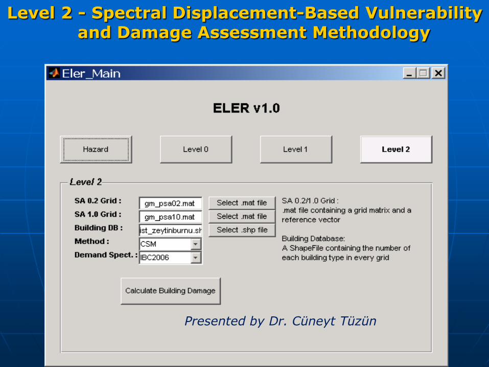
Level 2 - Spectral Displacement-Based Vulnerability and Damage Assessment Methodology
Presented by Dr. Cüneyt Tüzün

Building Damage Estimation
Level 1 (Intensity Based)(No station correction applied)
Attenuation
Buildings in each damage grade based on European Microseismic Scale – EMS,
1998
D3
(Substantial to heavy damage)
D4 + D5
(Damage beyond repair)
Akkar & Bommer 2007 648 63
Boore & Atkinson 2007 582 35
Boore et al. 1997 1112 85
Campbell & Bozorgnia 2007 494 36
D4: Very heavy damage
D5: Destruction

Some Remarks on ELER and Similar
ApplicationsIT Characteristics
• Developed with MATLAB (both computation and plots)
• Easy installation and use in different operating systems
• Modular-Based
• Easy incorporation of user-defined methods (e.g. attenuation, vulnerabilities)
Improvements in Shake Mapping
• Different techniques (FAS, local intensity attenuation relationships)
• Bias adjustment also at surface
Loss Assessment
• Robust loss estimation methodology
• Both European and HAZUS Building Taxonomies
• Incorporation of different levels of inventory sophistication
• Implementation of several well-tested analytical methods
• Both intensity and spectral displacement-based methods

Applications with ELER
Earthquake loss assessments for the Istanbul Metropolitan Municipality have been conducted with ELER
Earthquake risk assessment for the buried pipelines of the Istanbul Natural Gas Network will be conducted with ELER
ELER was selected as one of the tools to be tested in GEM, Los Angeles building inventory is being analyzed under Level 2 of ELER
Regional and urban scale risk assessments within EMME (Earthquake Model of Middle East) Project will be conducted with ELER
Istanbul Earthquake Rapid Response System will also be modified to adopt the analysis tools developed in ELER

Publications
RAPID EARTHQUAKE HAZARD and LOSS ASSESSMENT for EURO-MEDITERRANEAN REGIONMustafa Erdik, Karin Sesetyan, Mine Demircioglu, Ufuk Hancilar, Can
Zulfikar, Eser Durukal, Yaver Kamer, Cem Yenidogan, Cuneyt Tuzun, Zehra Cagnan, Ebru Harmandar
Acta Geophysica, 2010
RAPID EARTHQUAKE LOSS ASSESSMENT AFTER DAMAGING EARTHQUAKESM.Erdik, K.Şeşetyan, M.B.Demircioğlu, U.Hancılar, C.ZülfikarSoil Dynamics and Earthquake Engineering, 2010
ISTANBUL EARTHQUAKE RAPID RESPONSE SYSTEM: METHODS AND PRACTICESKarin Sesetyan, Can Zulfikar, Mine Demircioglu, Ufuk Hancilar, Yaver Kamer
and Mustafa ErdikSoil Dynamics and Earthquake Engineering, 2010
URBAN EARTHQUAKE LOSS ASSESSMENT Ufuk Hancılar , Cüneyt Tüzün, Cem Yenidoğan, Mustafa Erdik. (submitted to NHESS,)

THANK YOU
FOR
YOUR ATTENTION
ftp://www.orfeus-eu.org/pub/software/ELER/ELER_V3/