Executive Summary - New Mexico Department of...
29
South I-25 Corridor Study, NM 47/ Broadway Blvd to I-40 Highway Improvement Plan Report Phase IB Detailed Evaluation of Alternatives, CN A301100 October 2016 Executive Summary
Transcript of Executive Summary - New Mexico Department of...
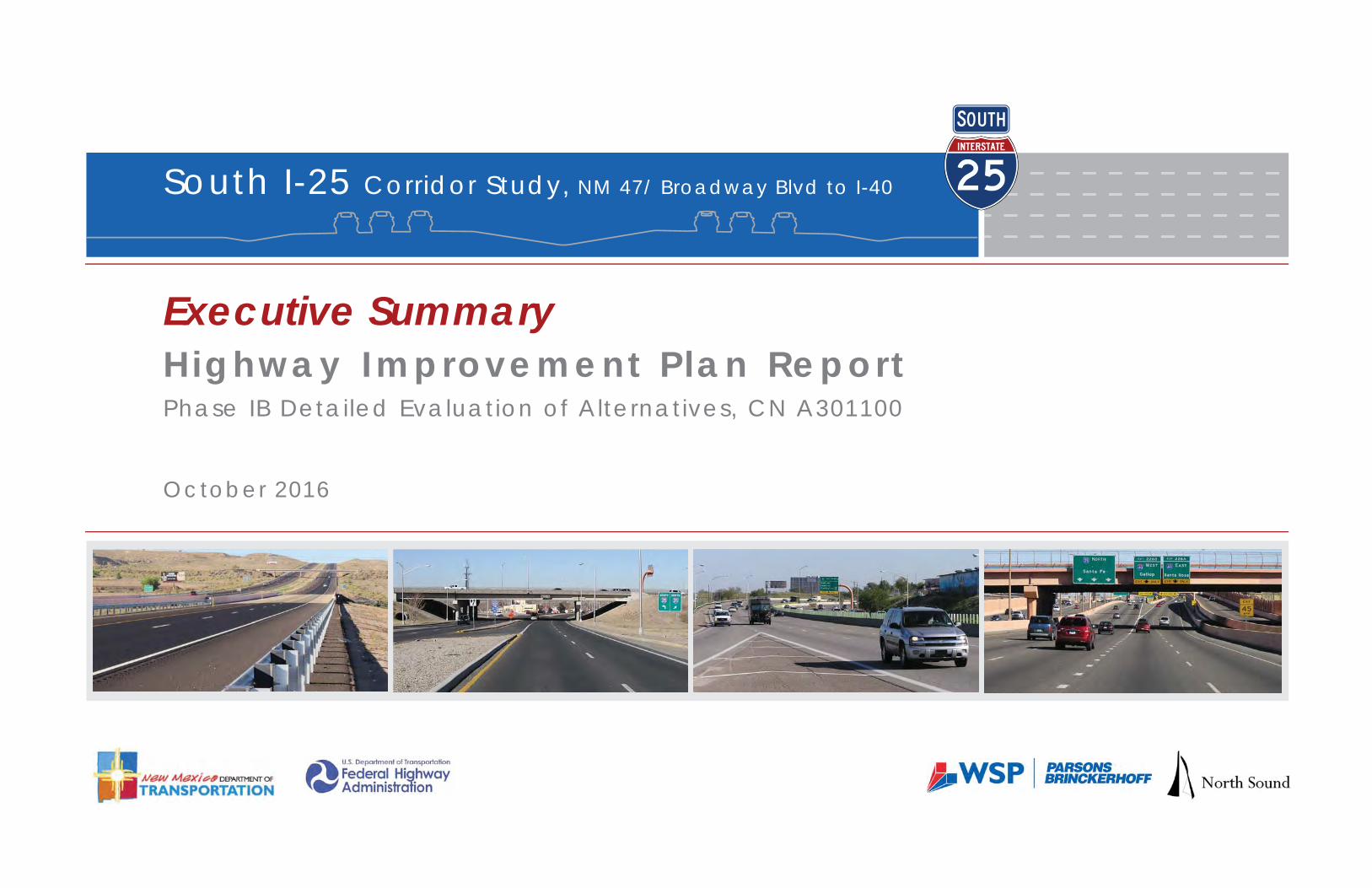
South I-25 Corridor Study, NM 47/ Broadway Blvd to I-40
Highway Improvement P lan Repor tPhase IB Detailed Evaluation of Alternatives, CN A301100
October 2016
Executive Summary

South I-25 Corridor Study, NM 47 to I-40 Executive Summary CN A301100 Highway Improvement Plan Report
Page |ES-1
Executive Summary INTRODUCTION The purpose of the South I-25 Corridor Study is to identify improvements needed to maintain and enhance the operational performance of South I-25 for the long-term planning horizon, which is currently 2040 for the Albuquerque metro area. The limits of the study include the I-25 facilities from the NM 47/Broadway Boulevard interchange to the south side of the I-40/I-25 interchange as shown in Exhibit ES-1.
The results of this study will enable NMDOT and MRCOG to plan for long-term needs in the Metropolitan Transportation Plan (MTP) and to program near-term improvements in the Transportation Improvement Program (TIP) and Statewide Transportation Improvement Program (STIP). Because of the scale of the needs and the anticipated costs, phased implementation is anticipated. This may require amendments to the existing approved TIP/STIP and will depend on funding availability within the fiscally-constrained MTP.
While significant improvements have been implemented and are ongoing in the South I-25 corridor, several deficiencies remain involving aging infrastructure, geometric design issues, namely the S-curve, and traffic
operational and safety performance. Access to and from the interstate must be managed to appropriately accommodate existing and future development, and transportation systems management and operations (TSM&O) applications are needed to maximize the performance of the system. Further, improved bicycle and pedestrian crossings of the interstate and accommodations for public transportation improvements are also part of the South I-25 preferred improvement alternative.
The improvement approach for the South I-25 corridor was developed in two main segments south and north of Sunport Boulevard as follows:
South Segment – NM 47/Broadway Boulevard interchange to the south side of the Sunport Boulevard interchange
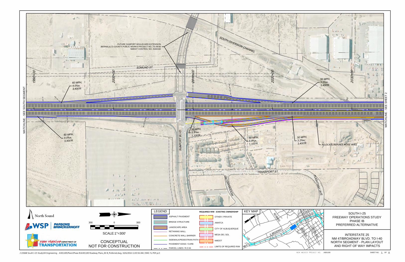
North Segment – from the south side of the Sunport Boulevard interchange to the south side of the I-40/I-25 interchange
One improvement alternative was evaluated for the south segment and three alternatives were evaluated for the north segment. Alternatives in the north segment included: B1, the Braided Ramps concept; B2, the Closest to Existing concept; and B3, the Collector-Distributor Roads concept.
Based on the engineering and environmental evaluations conducted, study team meeting discussions and considering stakeholder input, Alternatives B1 and B2 would perform similarly while the Alternative B3 concept was eliminated from further consideration because of property impacts and due to anticipated traffic performance concerns at the Gibson and Martin Luther King intersections. As such, the preferred alternative, as described herein, primarily combines features of both Alternative B1 and Alternative B2.
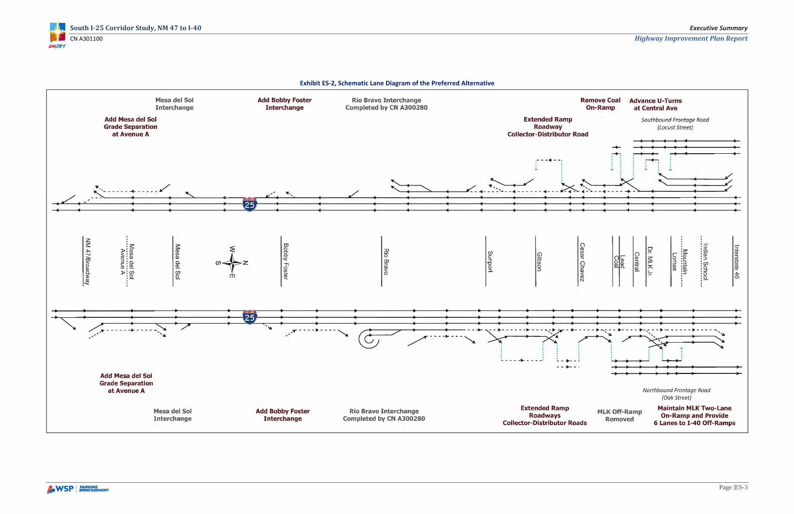
PREFERRED ALTERNATIVE A schematic lane diagram of the preferred alternative is provided as Exhibit ES-2 and the conceptual design drawings are provided in the attachment to this document.
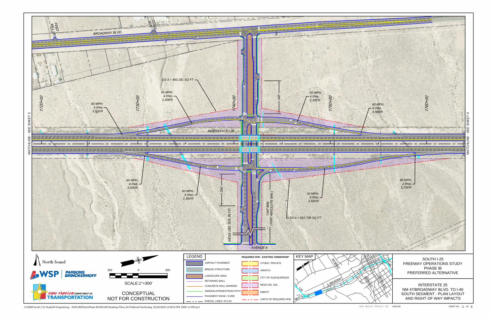
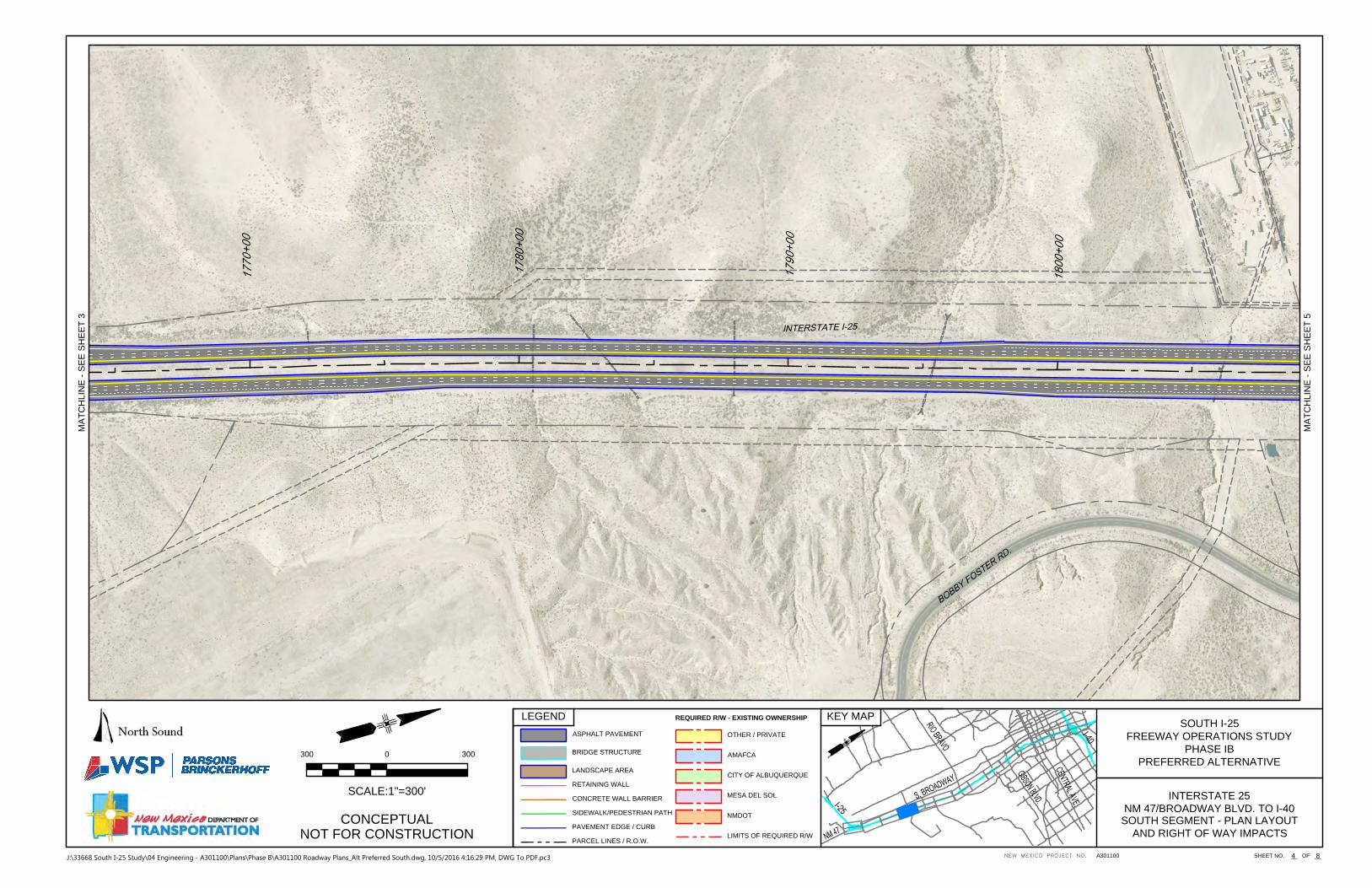
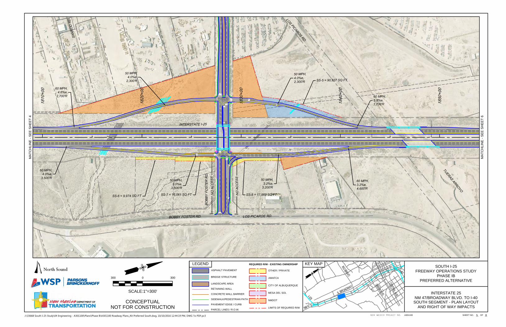
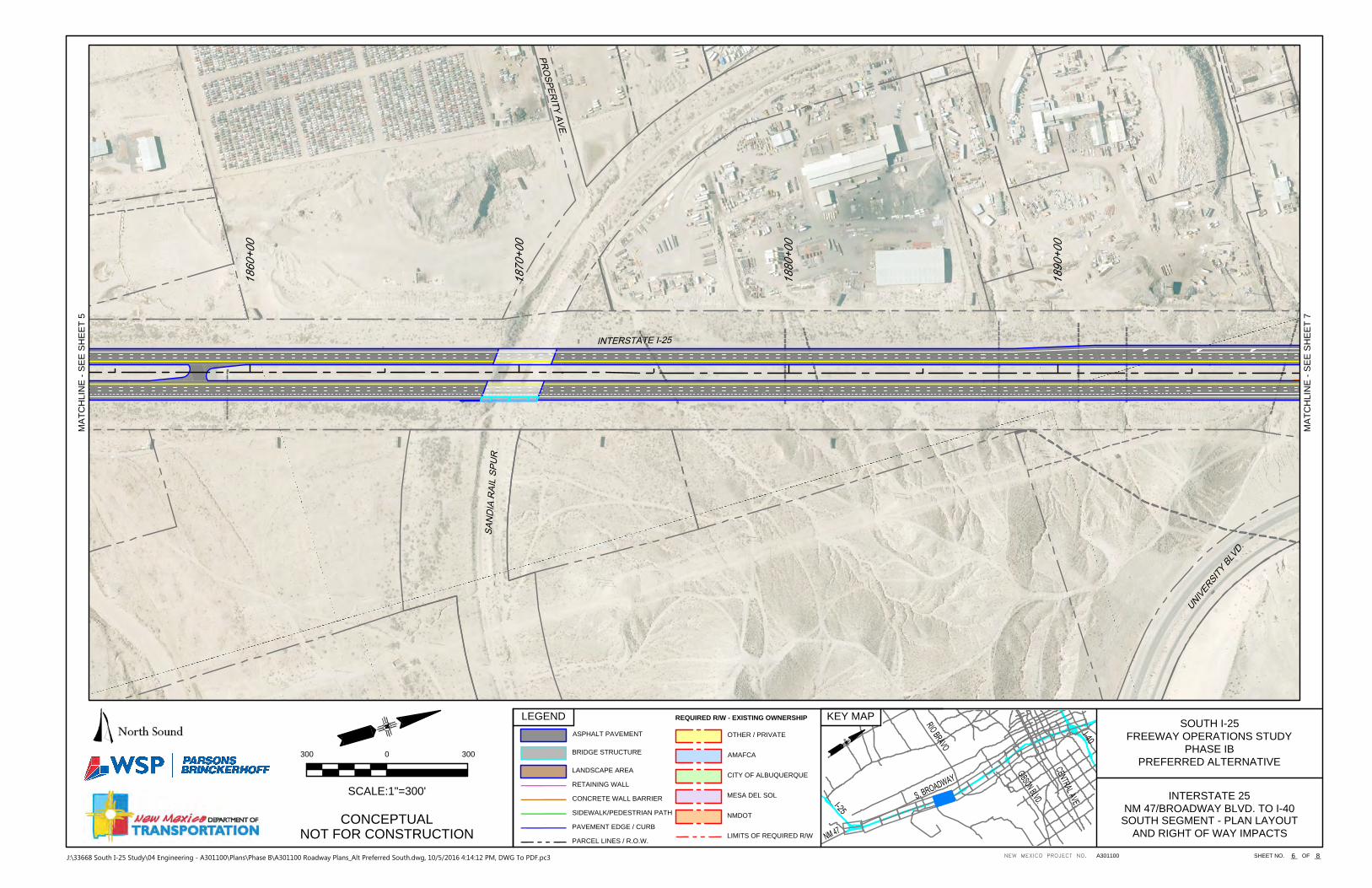
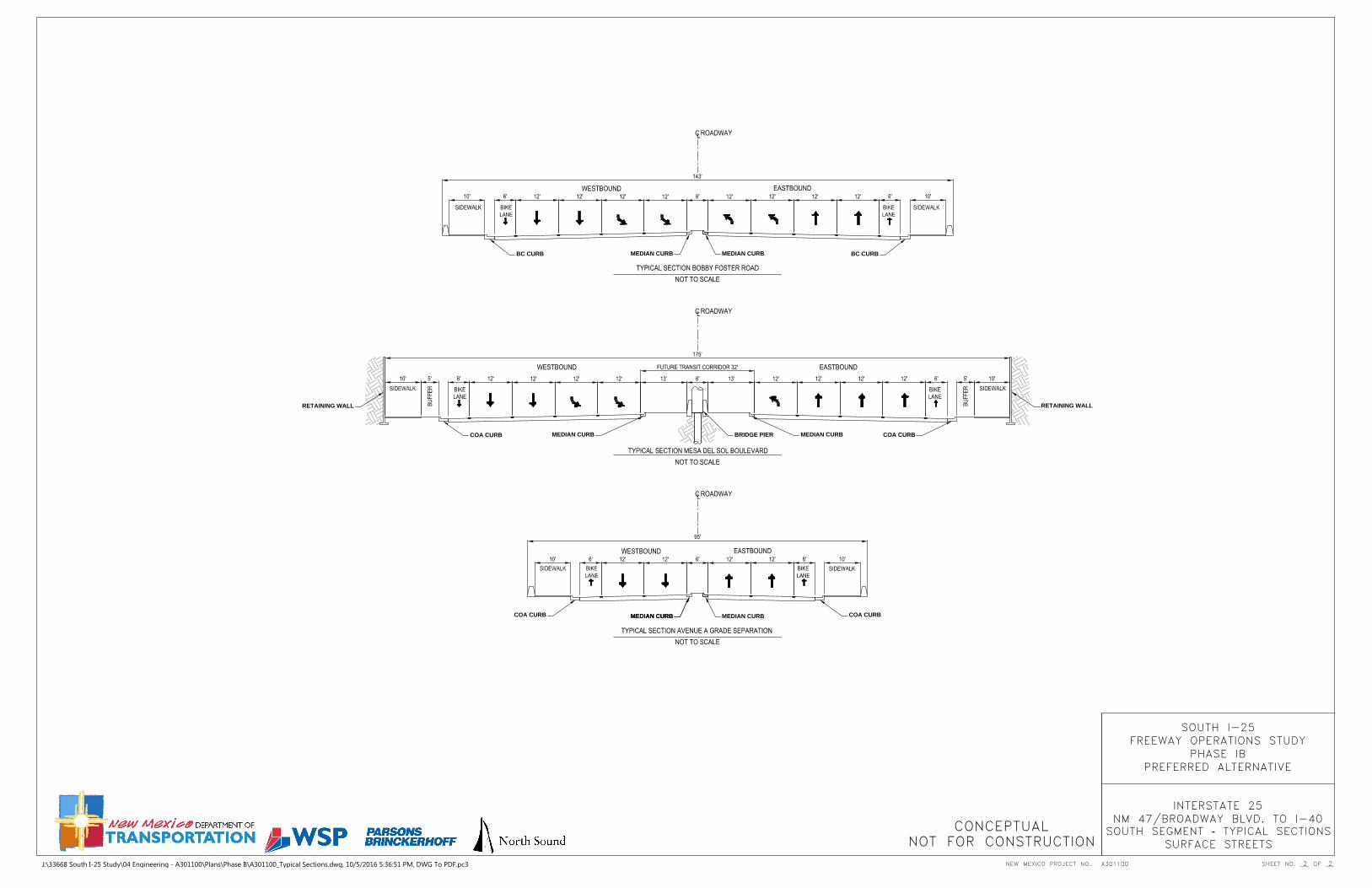
For the south segment, south of the NM 47/Broadway interchange, I-25 will remain in its existing configuration of a four-lane freeway with two lanes in each travel direction. From the NM 47/Broadway interchange to the Rio Bravo interchange, a six-lane freeway will be provided. From the Rio Bravo interchange to the Sunport interchange, the existing six-lane freeway will be improved to an eight-lane freeway. Ramp-to-ramp auxiliary lanes are identified in both travel directions between NM 47/ Broadway and Mesa del Sol, and in the northbound direction only from Bobby Foster to Rio Bravo and from Rio Bravo to Sunport.
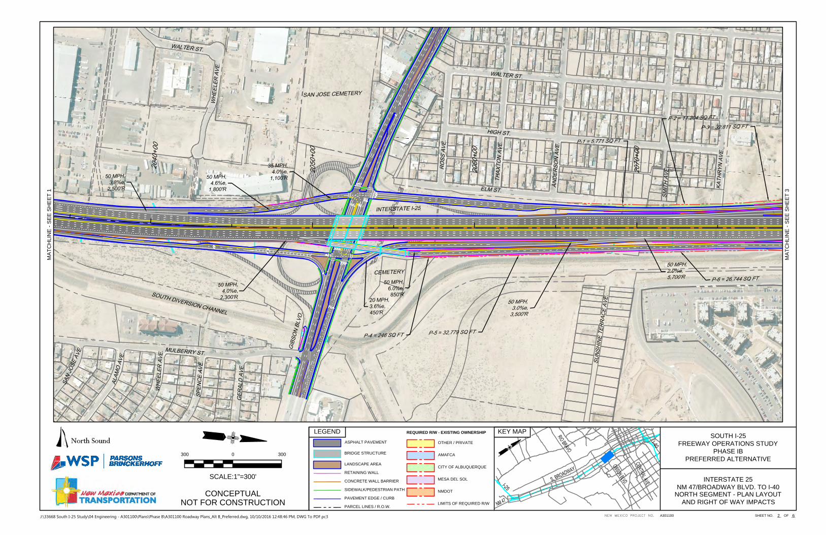
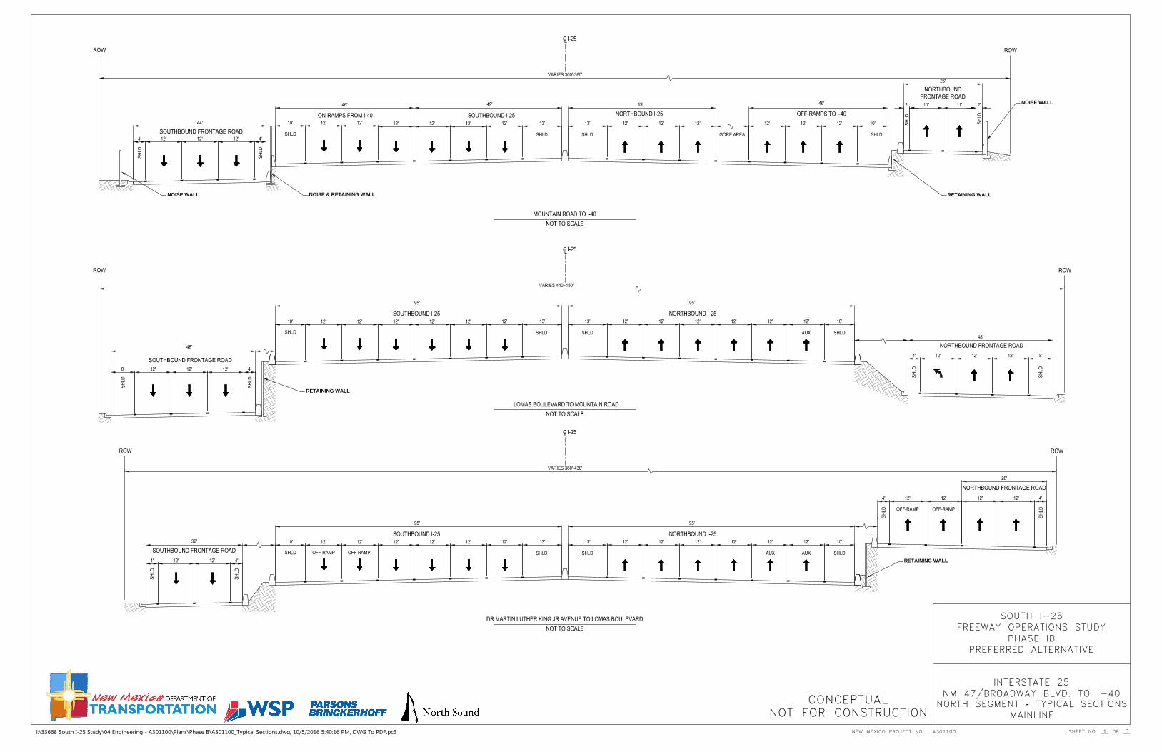
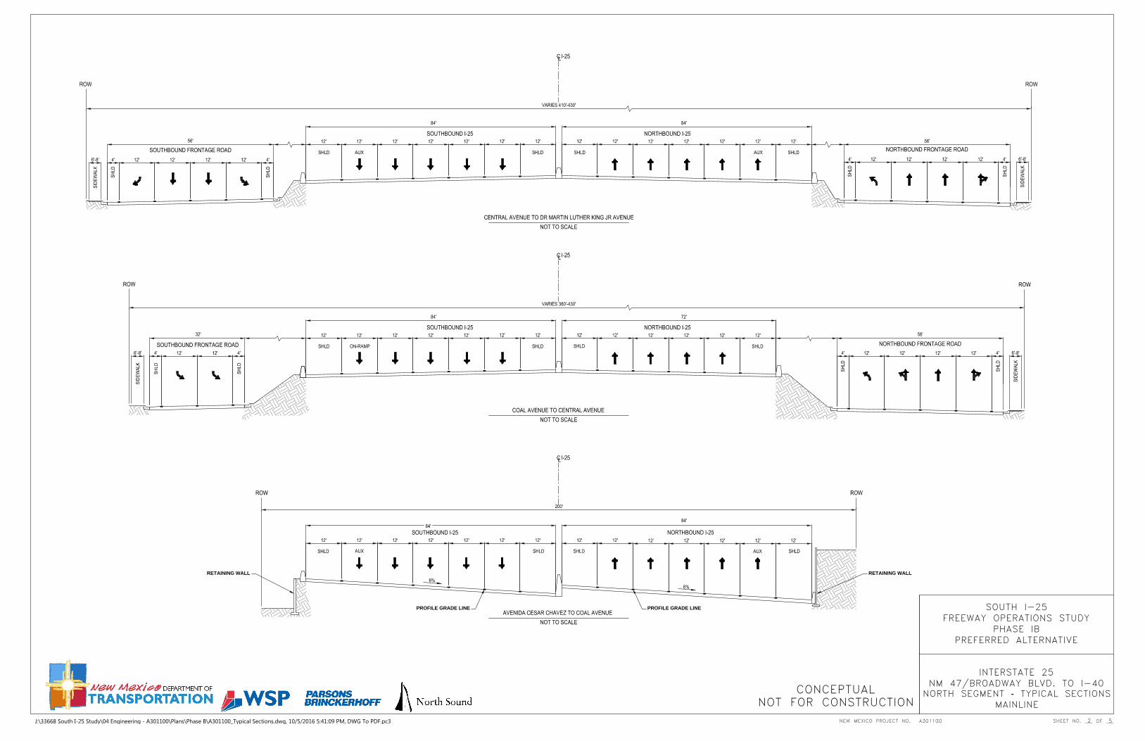
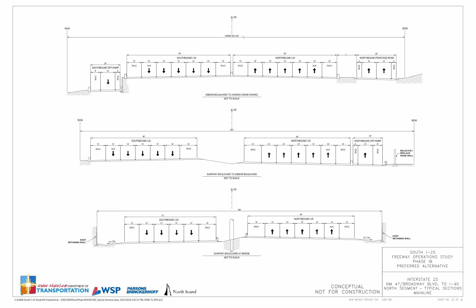
For the north segment, the existing six-lane freeway will be widened to an eight-lane freeway with auxiliary lanes incorporated including acceleration lanes, deceleration lanes and ramp-to-ramp auxiliary lanes. Braided ramps and two-lane exit ramps are also included. The interchange locations, configuration types and level of access provided are listed in Table ES-1.
Locations of existing and proposed grade separations where access is not provided to I-25 include: South Segment
- Avenue A (Mesa del Sol) – proposed overpass North Segment
- Mountain Road – existing underpass - Indian School Road – existing overpass
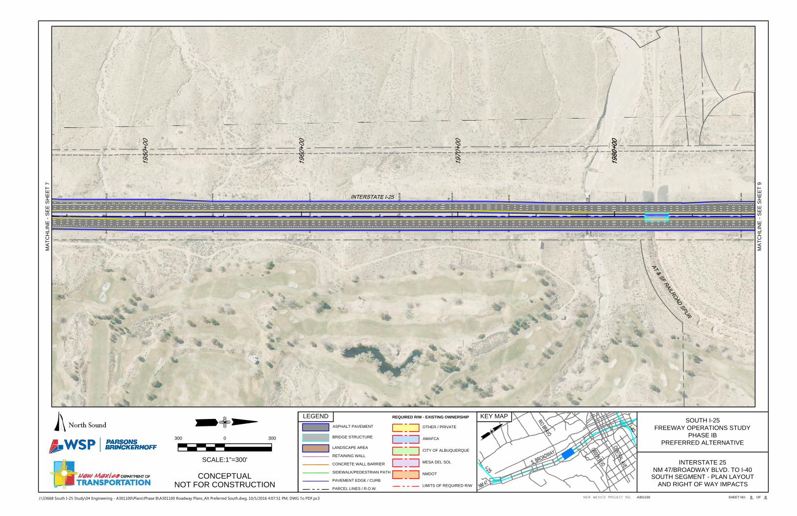
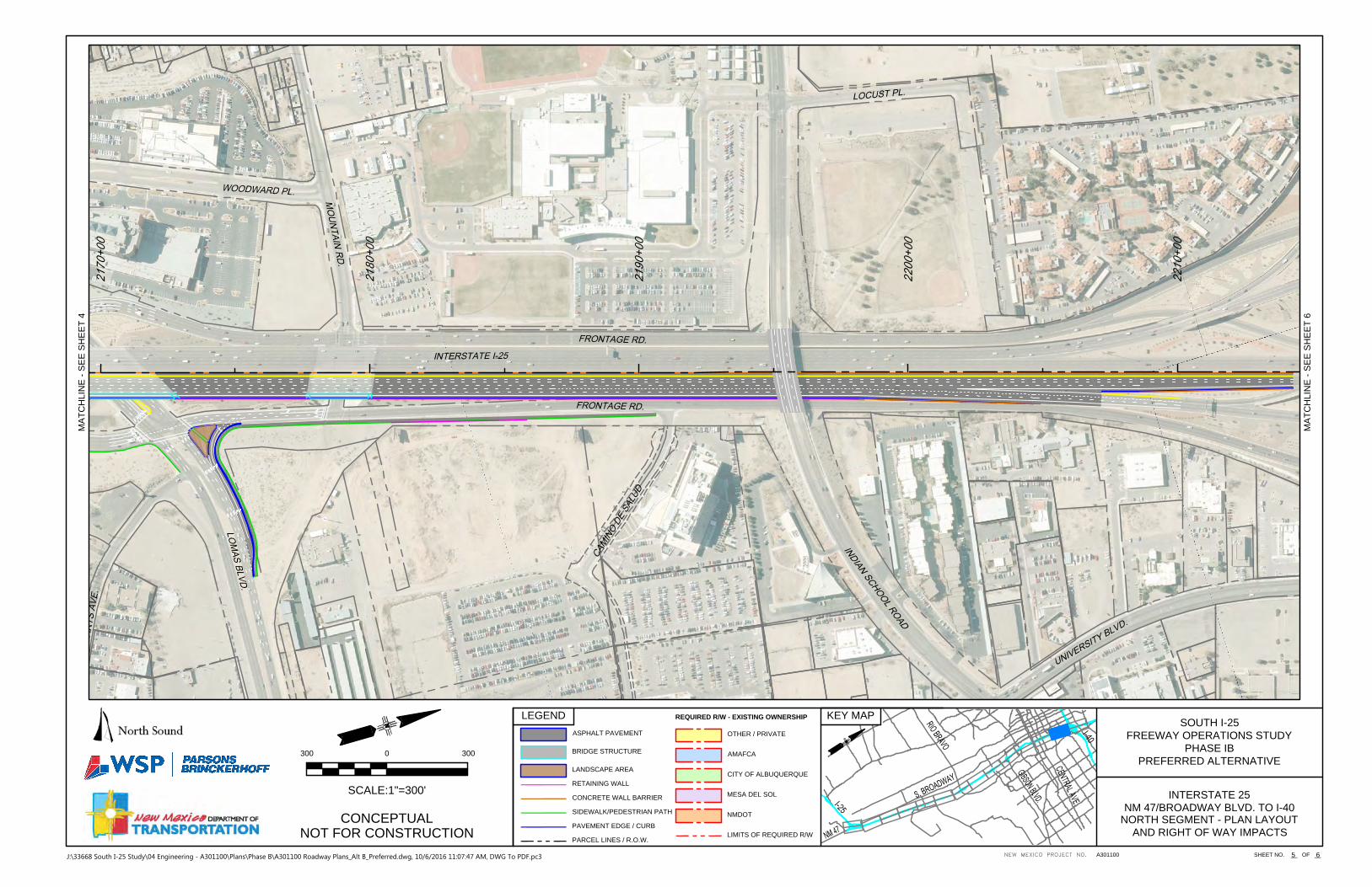
Service roads parallel to I-25 are included in the north segment. These include frontage roads, which provide access to adjacent properties, and collector-distributor (C-D) roads, which are controlled-access roadways that facilitate movements on and off the mainline freeway. In the north segment, Oak Street and Locust Street are existing frontage roads between Coal Avenue and the north study limits. Collector-distributor roads are provided northbound between Sunport and Gibson and between Gibson and Cesar Chavez. Southbound, a C-D road is provided between Cesar Chavez and Gibson (see Exhibit ES-2). There are no service roads proposed in the south segment.
Multi-modal improvements include bicycle and pedestrian facilities as well as accommodations for public transit. Bicycle and pedestrian accommodations included in the preferred alternative consist of 10-foot sidewalks with 5-foot buffers along with bike lanes and multi-use trails within the interchange areas and at arroyo crossings where possible. Accommodations for public transportation improvements include the Albuquerque Rapid Transit (ART) crossing along Central Avenue; accommodating dedicated transit lanes in the proposed I-25/Mesa del Sol interchange; and improving overall traffic performance across all interstate crossings that would benefit transit vehicles operating in mixed flows.
The preferred alternative will also include TSM&O improvements consistent with the regional Intelligent Transportation System (ITS) Infrastructure Plan. In addition to existing ITS facilities, at a minimum, improved traveler information systems, communications improvements and additional traffic monitoring devices in support of NMDOT ITS and MRCOG Traffic Monitoring activities should be included.
Exhibit ES-1, Map of Study Limits

South I-25 Corridor Study, NM 47 to I-40 Executive Summary CN A301100 Highway Improvement Plan Report
Page |ES-2
The preferred alternative will require additional right-of-way from private land owners and various public entities including the City of Albuquerque, the Albuquerque Metropolitan Area Flood Control Authority (AMAFCA), and Albuquerque Public Schools. Within the south segment, most of the new right-of-way needed for the improvements involves lands of the Mesa del Sol Planned Community development. The land needed for the Mesa del Sol interchange and for the east side of the Avenue A grade separation should be dedicated without cost to the pertinent highway jurisdictions because they directly serve the needs of the development.
Table ES-1, Interchange Locations, Types and Level of Access Provided
Arterial Cross Street Interchange Type Full or Partial Access Northbound I-25 Ramps Southbound I-25 Ramps
South Segment
NM 47/Broadway Blvd Existing Configuration Full 1 lane exit 2 lane entrance
2 lane exit1 lane entrance
Mesa del Sol Blvd Compressed Diamond (DDI optional) Full 2 lane exit
1 lane entrance 1 lane exit1 lane entrance
Bobby Foster Rd Compressed Diamond Full 1 lane exit 1 lane entrance
1 lane exit1 lane entrance
Rio Bravo Blvd Offset Single Point Full 1 lane exit 2 lane loop entrance E-N 1 lane entrance W-N
2 lane exit 1 lane entrance
North Segment
Sunport Blvd Tight Diamond Full 1 lane exit 1 lane entrance
1 lane exit2 lane entrance
Gibson Blvd Tight Diamond Full 1 lane exit, braided with C-D Road 1 lane entrance
1 lane exit, braided with C-D Road 1 lane entrance
Ave Cesar Chavez Tight Diamond Full 2 lane exit, braided with C-D Road 1 lane entrance
2 lane exit 1 lane entrance
Coal Ave Tight Diamond Configuration Partial 2 lane exit No direct access
Lead Ave Tight Diamond Configuration Partial 1 lane entrance 1 lane exit
Central Ave Tight Diamond Configuration Partial No direct access,
advance U-turn N-S 1 lane entrance, braided
MLK Ave Tight Diamond Configuration Partial 2 lane entrance 2 lane exit
Lomas Blvd Compressed Diamond Configuration Partial 2 lane exit 1 lane exit located within
I-40/I-25 interchange
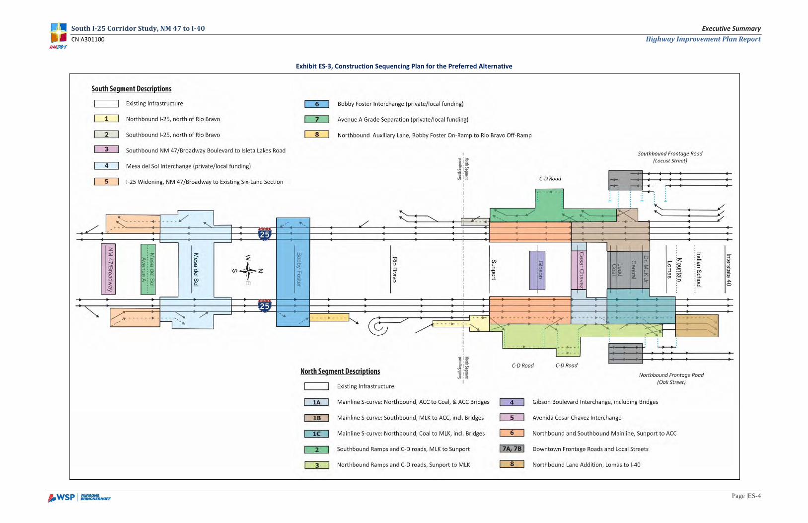
CONSTRUCTION SEQUENCING AND COST The proposed improvements will require a substantial capital investment and are expected to be implemented in phases. There are several approaches that could be utilized to phase and prioritize the identified improvements. However, in general, the south segment is a lower priority than the north segment, particularly once the Rio Bravo interchange reconstruction is completed. A construction sequencing plan for both the south and north segments is illustrated in Exhibit ES-3. This approach was developed based on a cost per phase ranging from $10 to $50 million to facilitate programming the identified improvements.
In addition to mainline widening to provide lane continuity, the south segment improvements also include new interchanges and a new grade separation (Mesa del Sol and Bobby Foster interchanges, and the Avenue A grade separation) but these are considered to be development-driven projects of primary interest to private entities and local governments including the City of Albuquerque and Bernalillo County. As such, these facilities should be locally and privately funded for the entire project development cycle from study/design through construction, including construction phase services. The opinion of probable construction costs, in 2016 dollars, for these development-driven projects in the south segment is $75 million. The cost for the other identified south segment improvements is estimated to be $20 million.
For the north segment, and the South I-25 corridor in general, the S-curve and associated facilities is considered to be the highest priority. Because of the complexities with reconstructing the S-curve, once construction begins it may be difficult to stop until the segment from the Avenida Cesar Chavez interchange to the MLK interchange is complete.
Table ES-2 presents a breakdown of conceptual probable costs for the south and north segments. The south segment is presented as an overall cost excluding the Rio Bravo interchange, which is already funded in the current TIP/STIP, and the development-based projects. The north segment costs are based on the phased approach presented in Exhibit ES-3.
Table ES-2, Summary of Construction Cost Estimates
South Segment Construction Costs (concept level) Estimated Cost (2016 dollars)
Combined South Segment Costs excluding Rio Bravo interchange and development-driven projects $20 million
North Segment Projects by Recommended Sequencing (concept level) Estimated Cost (2016 dollars)
Project 1- Mainline reconstruction-S-Curve
Project 1A-NB mainline reconstruction to downtown area $23 million
Project 1B-Southbound (SB) mainline reconstruction $45 million
Project 1C-Complete NB mainline construction through downtown area $30 million
Project 2-Construct SB ramps and C-D roads $16 million
Project 3-Construct NB ramps and C-D roads $30 million
Project 4-Construct Gibson Boulevard interchange $25 million
Project 5-Improvements to Avenida Cesar Chavez $15 million
Project 6-Complete NB and SB mainline, Sta. 1980+00 to Sta. 2088+00 $25 million
Project 7-Downtown frontage roads
Project 7A-NB Downtown frontage roads (Oak Street) $11 million
Project 7B-SB Downtown frontage roads (Locust Street) $11 million
Project 8-Complete NB lane addition construction on north end $15 million
Total Opinion of Probable Construction Cost for North Segment $246 million
South I-25 Corridor Study, NM 47 to I-40 Executive Summary CN A301100 Highway Improvement Plan Report
Page |ES-3
Exhibit ES-2, Schematic Lane Diagram of the Preferred Alternative
South I-25 Corridor Study, NM 47 to I-40 Executive Summary CN A301100 Highway Improvement Plan Report
Page |ES-4
Exhibit ES-3, Construction Sequencing Plan for the Preferred Alternative
South I-25 Corridor Study, NM 47 to I-40 Executive Summary - Attachment CN A301100 Highway Improvement Plan Report
ATTACHMENT Conceptual Design Plans for the Preferred Alternative
MA
TCH
LIN
E -
SE
E S
HE
ET
2
81A301100NEW MEXICO PROJECT NO. SHEET NO.
CONCEPTUALNOT FOR CONSTRUCTION
KEY MAPLEGEND
300 3000
SCALE:1"=300'
__ OF __
SOUTH I-25FREEWAY OPERATIONS STUDY
PHASE IBPREFERRED ALTERNATIVE
INTERSTATE 25NM 47/BROADWAY BLVD. TO I-40
ASPHALT PAVEMENT
BRIDGE STRUCTURE
LANDSCAPE AREA
RETAINING WALL
CONCRETE WALL BARRIER
SIDEWALK/PEDESTRIAN PATH
PAVEMENT EDGE / CURB
PARCEL LINES / R.O.W.
OTHER / PRIVATE
MESA DEL SOL
AMAFCA
CITY OF ALBUQUERQUE
NMDOT
LIMITS OF REQUIRED R/W
REQUIRED R/W - EXISTING OWNERSHIP
SOUTH SEGMENT - PLAN LAYOUTAND RIGHT OF WAY IMPACTS
J:\33668 South I-25 Study\04 Engineering - A301100\Plans\Phase B\A301100 Roadway Plans_Alt Preferred South.dwg, 10/5/2016 4:20:10 PM, DWG To PDF.pc3

SS-1 = 96,458 SQ FT
SS-2 = 180,123 SQ FT
MA
TCH
LIN
E -
SE
E S
HE
ET
3
82
MA
TCH
LIN
E -
SE
E S
HE
ET
1
A301100NEW MEXICO PROJECT NO. SHEET NO.
CONCEPTUALNOT FOR CONSTRUCTION
KEY MAPLEGEND
300 3000
SCALE:1"=300'
__ OF __
SOUTH I-25FREEWAY OPERATIONS STUDY
PHASE IBPREFERRED ALTERNATIVE
INTERSTATE 25NM 47/BROADWAY BLVD. TO I-40
ASPHALT PAVEMENT
BRIDGE STRUCTURE
LANDSCAPE AREA
RETAINING WALL
CONCRETE WALL BARRIER
SIDEWALK/PEDESTRIAN PATH
PAVEMENT EDGE / CURB
PARCEL LINES / R.O.W.
OTHER / PRIVATE
MESA DEL SOL
AMAFCA
CITY OF ALBUQUERQUE
NMDOT
LIMITS OF REQUIRED R/W
REQUIRED R/W - EXISTING OWNERSHIP
SOUTH SEGMENT - PLAN LAYOUTAND RIGHT OF WAY IMPACTS
J:\33668 South I-25 Study\04 Engineering - A301100\Plans\Phase B\A301100 Roadway Plans_Alt Preferred South.dwg, 10/5/2016 4:18:33 PM, DWG To PDF.pc3
60 MPH,
4.0%e,
3,500'R
50 MPH,
4.0%e,
2,300'R
50 MPH,
3.0%e,
3,500'R
60 MPH,
2.8%e,
5,700'R
50 MPH,
4.0%e,
2,300'R
60 MPH,
4.0%e,
3,500'R
50 MPH,
4.0%e,
2,300'R
60 MPH,
4.0%e,
3,500'R
SS-3 = 450,181 SQ FT
SS-4 = 662,738 SQ FT
MA
TCH
LIN
E -
SE
E S
HE
ET
4
83
MA
TCH
LIN
E -
SE
E S
HE
ET
2
A301100NEW MEXICO PROJECT NO. SHEET NO.
CONCEPTUALNOT FOR CONSTRUCTION
KEY MAPLEGEND
300 3000
SCALE:1"=300'
__ OF __
SOUTH I-25FREEWAY OPERATIONS STUDY
PHASE IBPREFERRED ALTERNATIVE
INTERSTATE 25NM 47/BROADWAY BLVD. TO I-40
ASPHALT PAVEMENT
BRIDGE STRUCTURE
LANDSCAPE AREA
RETAINING WALL
CONCRETE WALL BARRIER
SIDEWALK/PEDESTRIAN PATH
PAVEMENT EDGE / CURB
PARCEL LINES / R.O.W.
OTHER / PRIVATE
MESA DEL SOL
AMAFCA
CITY OF ALBUQUERQUE
NMDOT
LIMITS OF REQUIRED R/W
REQUIRED R/W - EXISTING OWNERSHIP
SOUTH SEGMENT - PLAN LAYOUTAND RIGHT OF WAY IMPACTS
J:\33668 South I-25 Study\04 Engineering - A301100\Plans\Phase B\A301100 Roadway Plans_Alt Preferred South.dwg, 10/10/2016 12:40:33 PM, DWG To PDF.pc3
MA
TCH
LIN
E -
SE
E S
HE
ET
5
84
MA
TCH
LIN
E -
SE
E S
HE
ET
3
A301100NEW MEXICO PROJECT NO. SHEET NO.
CONCEPTUALNOT FOR CONSTRUCTION
KEY MAPLEGEND
300 3000
SCALE:1"=300'
__ OF __
SOUTH I-25FREEWAY OPERATIONS STUDY
PHASE IBPREFERRED ALTERNATIVE
INTERSTATE 25NM 47/BROADWAY BLVD. TO I-40
ASPHALT PAVEMENT
BRIDGE STRUCTURE
LANDSCAPE AREA
RETAINING WALL
CONCRETE WALL BARRIER
SIDEWALK/PEDESTRIAN PATH
PAVEMENT EDGE / CURB
PARCEL LINES / R.O.W.
OTHER / PRIVATE
MESA DEL SOL
AMAFCA
CITY OF ALBUQUERQUE
NMDOT
LIMITS OF REQUIRED R/W
REQUIRED R/W - EXISTING OWNERSHIP
SOUTH SEGMENT - PLAN LAYOUTAND RIGHT OF WAY IMPACTS
J:\33668 South I-25 Study\04 Engineering - A301100\Plans\Phase B\A301100 Roadway Plans_Alt Preferred South.dwg, 10/5/2016 4:16:29 PM, DWG To PDF.pc3
MA
TCH
LIN
E -
SE
E S
HE
ET
6
85
MA
TCH
LIN
E -
SE
E S
HE
ET
4
A301100NEW MEXICO PROJECT NO. SHEET NO.
CONCEPTUALNOT FOR CONSTRUCTION
KEY MAPLEGEND
300 3000
SCALE:1"=300'
__ OF __
SOUTH I-25FREEWAY OPERATIONS STUDY
PHASE IBPREFERRED ALTERNATIVE
INTERSTATE 25NM 47/BROADWAY BLVD. TO I-40
ASPHALT PAVEMENT
BRIDGE STRUCTURE
LANDSCAPE AREA
RETAINING WALL
CONCRETE WALL BARRIER
SIDEWALK/PEDESTRIAN PATH
PAVEMENT EDGE / CURB
PARCEL LINES / R.O.W.
OTHER / PRIVATE
MESA DEL SOL
AMAFCA
CITY OF ALBUQUERQUE
NMDOT
LIMITS OF REQUIRED R/W
REQUIRED R/W - EXISTING OWNERSHIP
SOUTH SEGMENT - PLAN LAYOUTAND RIGHT OF WAY IMPACTS
J:\33668 South I-25 Study\04 Engineering - A301100\Plans\Phase B\A301100 Roadway Plans_Alt Preferred South.dwg, 10/10/2016 12:44:19 PM, DWG To PDF.pc3
MA
TCH
LIN
E -
SE
E S
HE
ET
7
86
MA
TCH
LIN
E -
SE
E S
HE
ET
5
A301100NEW MEXICO PROJECT NO. SHEET NO.
CONCEPTUALNOT FOR CONSTRUCTION
KEY MAPLEGEND
300 3000
SCALE:1"=300'
__ OF __
SOUTH I-25FREEWAY OPERATIONS STUDY
PHASE IBPREFERRED ALTERNATIVE
INTERSTATE 25NM 47/BROADWAY BLVD. TO I-40
ASPHALT PAVEMENT
BRIDGE STRUCTURE
LANDSCAPE AREA
RETAINING WALL
CONCRETE WALL BARRIER
SIDEWALK/PEDESTRIAN PATH
PAVEMENT EDGE / CURB
PARCEL LINES / R.O.W.
OTHER / PRIVATE
MESA DEL SOL
AMAFCA
CITY OF ALBUQUERQUE
NMDOT
LIMITS OF REQUIRED R/W
REQUIRED R/W - EXISTING OWNERSHIP
SOUTH SEGMENT - PLAN LAYOUTAND RIGHT OF WAY IMPACTS
J:\33668 South I-25 Study\04 Engineering - A301100\Plans\Phase B\A301100 Roadway Plans_Alt Preferred South.dwg, 10/5/2016 4:14:12 PM, DWG To PDF.pc3

MA
TCH
LIN
E -
SE
E S
HE
ET
8
87
MA
TCH
LIN
E -
SE
E S
HE
ET
6
A301100NEW MEXICO PROJECT NO. SHEET NO.
CONCEPTUALNOT FOR CONSTRUCTION
KEY MAPLEGEND
300 3000
SCALE:1"=300'
__ OF __
SOUTH I-25FREEWAY OPERATIONS STUDY
PHASE IBPREFERRED ALTERNATIVE
INTERSTATE 25NM 47/BROADWAY BLVD. TO I-40
ASPHALT PAVEMENT
BRIDGE STRUCTURE
LANDSCAPE AREA
RETAINING WALL
CONCRETE WALL BARRIER
SIDEWALK/PEDESTRIAN PATH
PAVEMENT EDGE / CURB
PARCEL LINES / R.O.W.
OTHER / PRIVATE
MESA DEL SOL
AMAFCA
CITY OF ALBUQUERQUE
NMDOT
LIMITS OF REQUIRED R/W
REQUIRED R/W - EXISTING OWNERSHIP
SOUTH SEGMENT - PLAN LAYOUTAND RIGHT OF WAY IMPACTS
J:\33668 South I-25 Study\04 Engineering - A301100\Plans\Phase B\A301100 Roadway Plans_Alt Preferred South.dwg, 10/5/2016 4:12:39 PM, DWG To PDF.pc3
MA
TCH
LIN
E -
SE
E S
HE
ET
9
88
MA
TCH
LIN
E -
SE
E S
HE
ET
7
SOUTH SEGMENT - PLAN LAYOUTAND RIGHT OF WAY IMPACTS
A301100NEW MEXICO PROJECT NO. SHEET NO.
CONCEPTUALNOT FOR CONSTRUCTION
KEY MAPLEGEND
300 3000
SCALE:1"=300'
__ OF __
SOUTH I-25FREEWAY OPERATIONS STUDY
PHASE IBPREFERRED ALTERNATIVE
INTERSTATE 25NM 47/BROADWAY BLVD. TO I-40
ASPHALT PAVEMENT
BRIDGE STRUCTURE
LANDSCAPE AREA
RETAINING WALL
CONCRETE WALL BARRIER
SIDEWALK/PEDESTRIAN PATH
PAVEMENT EDGE / CURB
PARCEL LINES / R.O.W.
OTHER / PRIVATE
MESA DEL SOL
AMAFCA
CITY OF ALBUQUERQUE
NMDOT
LIMITS OF REQUIRED R/W
REQUIRED R/W - EXISTING OWNERSHIP
J:\33668 South I-25 Study\04 Engineering - A301100\Plans\Phase B\A301100 Roadway Plans_Alt Preferred South.dwg, 10/5/2016 4:07:51 PM, DWG To PDF.pc3

NEW MEXICO PROJECT NO. SHEET NO.
CONCEPTUALNOT FOR CONSTRUCTION
SOUTH I-25FREEWAY OPERATIONS STUDY
PHASE IBPREFERRED ALTERNATIVE
INTERSTATE 25NM 47/BROADWAY BLVD. TO I-40SOUTH SEGMENT - TYPICAL SECTIONS
MAINLINE
1 2J:\33668 South I-25 Study\04 Engineering - A301100\Plans\Phase B\A301100_Typical Sections.dwg, 10/5/2016 5:37:26 PM, DWG To PDF.pc3
BC CURBMEDIAN CURB
BC CURBMEDIAN CURB
COA CURBCOA CURB
RETAINING WALLRETAINING WALL
BRIDGE PIERMEDIAN CURBMEDIAN CURB
MEDIAN CURB
COA CURB
MEDIAN CURB
COA CURB
MEDIAN CURB
NEW MEXICO PROJECT NO. SHEET NO.
CONCEPTUALNOT FOR CONSTRUCTION
SOUTH I-25FREEWAY OPERATIONS STUDY
PHASE IBPREFERRED ALTERNATIVE
INTERSTATE 25NM 47/BROADWAY BLVD. TO I-40
2 2
SOUTH SEGMENT - TYPICAL SECTIONSSURFACE STREETS
J:\33668 South I-25 Study\04 Engineering - A301100\Plans\Phase B\A301100_Typical Sections.dwg, 10/5/2016 5:36:51 PM, DWG To PDF.pc3
MA
TCH
LIN
E -
SE
E S
HE
ET
2
61
MA
TCH
LIN
E -
SE
E S
OU
TH S
EG
ME
NT
FUTURE SUNPORT BOULEVARD EXTENSIONBERNALILLO COUNTY PUBLIC WORKS PROJECT NO. TS.09-06
NMDOT CONTROL NO. A300160
A301100NEW MEXICO PROJECT NO. SHEET NO.
CONCEPTUALNOT FOR CONSTRUCTION
KEY MAPLEGEND
300 3000
SCALE:1"=300'
__ OF __
SOUTH I-25FREEWAY OPERATIONS STUDY
PHASE IBPREFERRED ALTERNATIVE
INTERSTATE 25NM 47/BROADWAY BLVD. TO I-40
ASPHALT PAVEMENT
BRIDGE STRUCTURE
LANDSCAPE AREA
RETAINING WALL
CONCRETE WALL BARRIER
SIDEWALK/PEDESTRIAN PATH
PAVEMENT EDGE / CURB
PARCEL LINES / R.O.W.
OTHER / PRIVATE
MESA DEL SOL
AMAFCA
CITY OF ALBUQUERQUE
NMDOT
LIMITS OF REQUIRED R/W
REQUIRED R/W - EXISTING OWNERSHIP
NORTH SEGMENT - PLAN LAYOUTAND RIGHT OF WAY IMPACTS
J:\33668 South I-25 Study\04 Engineering - A301100\Plans\Phase B\A301100 Roadway Plans_Alt B_Preferred.dwg, 10/6/2016 11:03:56 AM, DWG To PDF.pc3
MA
TCH
LIN
E -
SE
E S
HE
ET
3
62
MA
TCH
LIN
E -
SE
E S
HE
ET
1
A301100NEW MEXICO PROJECT NO. SHEET NO.
CONCEPTUALNOT FOR CONSTRUCTION
KEY MAPLEGEND
300 3000
SCALE:1"=300'
__ OF __
SOUTH I-25FREEWAY OPERATIONS STUDY
PHASE IBPREFERRED ALTERNATIVE
INTERSTATE 25NM 47/BROADWAY BLVD. TO I-40
ASPHALT PAVEMENT
BRIDGE STRUCTURE
LANDSCAPE AREA
RETAINING WALL
CONCRETE WALL BARRIER
SIDEWALK/PEDESTRIAN PATH
PAVEMENT EDGE / CURB
PARCEL LINES / R.O.W.
OTHER / PRIVATE
MESA DEL SOL
AMAFCA
CITY OF ALBUQUERQUE
NMDOT
LIMITS OF REQUIRED R/W
REQUIRED R/W - EXISTING OWNERSHIP
NORTH SEGMENT - PLAN LAYOUTAND RIGHT OF WAY IMPACTS
J:\33668 South I-25 Study\04 Engineering - A301100\Plans\Phase B\A301100 Roadway Plans_Alt B_Preferred.dwg, 10/10/2016 12:48:46 PM, DWG To PDF.pc3

MA
TCH
LIN
E -
SE
E S
HE
ET
4
63
MA
TCH
LIN
E -
SE
E S
HE
ET
2
A301100NEW MEXICO PROJECT NO. SHEET NO.
CONCEPTUALNOT FOR CONSTRUCTION
KEY MAPLEGEND
300 3000
SCALE:1"=300'
__ OF __
SOUTH I-25FREEWAY OPERATIONS STUDY
PHASE IBPREFERRED ALTERNATIVE
INTERSTATE 25NM 47/BROADWAY BLVD. TO I-40
ASPHALT PAVEMENT
BRIDGE STRUCTURE
LANDSCAPE AREA
RETAINING WALL
CONCRETE WALL BARRIER
SIDEWALK/PEDESTRIAN PATH
PAVEMENT EDGE / CURB
PARCEL LINES / R.O.W.
OTHER / PRIVATE
MESA DEL SOL
AMAFCA
CITY OF ALBUQUERQUE
NMDOT
LIMITS OF REQUIRED R/W
REQUIRED R/W - EXISTING OWNERSHIP
NORTH SEGMENT - PLAN LAYOUTAND RIGHT OF WAY IMPACTS
J:\33668 South I-25 Study\04 Engineering - A301100\Plans\Phase B\A301100 Roadway Plans_Alt B_Preferred.dwg, 10/10/2016 12:48:17 PM, DWG To PDF.pc3

MA
TCH
LIN
E -
SE
E S
HE
ET
5
64
MA
TCH
LIN
E -
SE
E S
HE
ET
3
A301100NEW MEXICO PROJECT NO. SHEET NO.
CONCEPTUALNOT FOR CONSTRUCTION
KEY MAPLEGEND
300 3000
SCALE:1"=300'
__ OF __
SOUTH I-25FREEWAY OPERATIONS STUDY
PHASE IBPREFERRED ALTERNATIVE
INTERSTATE 25NM 47/BROADWAY BLVD. TO I-40
ASPHALT PAVEMENT
BRIDGE STRUCTURE
LANDSCAPE AREA
RETAINING WALL
CONCRETE WALL BARRIER
SIDEWALK/PEDESTRIAN PATH
PAVEMENT EDGE / CURB
PARCEL LINES / R.O.W.
OTHER / PRIVATE
MESA DEL SOL
AMAFCA
CITY OF ALBUQUERQUE
NMDOT
LIMITS OF REQUIRED R/W
REQUIRED R/W - EXISTING OWNERSHIP
NORTH SEGMENT - PLAN LAYOUTAND RIGHT OF WAY IMPACTS
J:\33668 South I-25 Study\04 Engineering - A301100\Plans\Phase B\A301100 Roadway Plans_Alt B_Preferred.dwg, 10/10/2016 12:47:46 PM, DWG To PDF.pc3
MA
TCH
LIN
E -
SE
E S
HE
ET
6
65
MA
TCH
LIN
E -
SE
E S
HE
ET
4
A301100NEW MEXICO PROJECT NO. SHEET NO.
CONCEPTUALNOT FOR CONSTRUCTION
KEY MAPLEGEND
300 3000
SCALE:1"=300'
__ OF __
SOUTH I-25FREEWAY OPERATIONS STUDY
PHASE IBPREFERRED ALTERNATIVE
INTERSTATE 25NM 47/BROADWAY BLVD. TO I-40
ASPHALT PAVEMENT
BRIDGE STRUCTURE
LANDSCAPE AREA
RETAINING WALL
CONCRETE WALL BARRIER
SIDEWALK/PEDESTRIAN PATH
PAVEMENT EDGE / CURB
PARCEL LINES / R.O.W.
OTHER / PRIVATE
MESA DEL SOL
AMAFCA
CITY OF ALBUQUERQUE
NMDOT
LIMITS OF REQUIRED R/W
REQUIRED R/W - EXISTING OWNERSHIP
NORTH SEGMENT - PLAN LAYOUTAND RIGHT OF WAY IMPACTS
J:\33668 South I-25 Study\04 Engineering - A301100\Plans\Phase B\A301100 Roadway Plans_Alt B_Preferred.dwg, 10/6/2016 11:07:47 AM, DWG To PDF.pc3

66
MA
TCH
LIN
E -
SE
E S
HE
ET
5
A301100NEW MEXICO PROJECT NO. SHEET NO.
CONCEPTUALNOT FOR CONSTRUCTION
KEY MAPLEGEND
300 3000
SCALE:1"=300'
__ OF __
SOUTH I-25FREEWAY OPERATIONS STUDY
PHASE IBPREFERRED ALTERNATIVE
INTERSTATE 25NM 47/BROADWAY BLVD. TO I-40
ASPHALT PAVEMENT
BRIDGE STRUCTURE
LANDSCAPE AREA
RETAINING WALL
CONCRETE WALL BARRIER
SIDEWALK/PEDESTRIAN PATH
PAVEMENT EDGE / CURB
PARCEL LINES / R.O.W.
OTHER / PRIVATE
MESA DEL SOL
AMAFCA
CITY OF ALBUQUERQUE
NMDOT
LIMITS OF REQUIRED R/W
REQUIRED R/W - EXISTING OWNERSHIP
NORTH SEGMENT - PLAN LAYOUTAND RIGHT OF WAY IMPACTS
J:\33668 South I-25 Study\04 Engineering - A301100\Plans\Phase B\A301100 Roadway Plans_Alt B_Preferred.dwg, 10/6/2016 11:08:21 AM, DWG To PDF.pc3
RETAINING WALL
RETAINING WALL
RETAINING WALL
NOISE WALL
NOISE WALL NOISE & RETAINING WALL
NEW MEXICO PROJECT NO. SHEET NO.
CONCEPTUALNOT FOR CONSTRUCTION
SOUTH I-25FREEWAY OPERATIONS STUDY
PHASE IBPREFERRED ALTERNATIVE
INTERSTATE 25NM 47/BROADWAY BLVD. TO I-40NORTH SEGMENT - TYPICAL SECTIONS
MAINLINE
1 5J:\33668 South I-25 Study\04 Engineering - A301100\Plans\Phase B\A301100_Typical Sections.dwg, 10/5/2016 5:40:16 PM, DWG To PDF.pc3
RETAINING WALL
PROFILE GRADE LINE PROFILE GRADE LINE
RETAINING WALL
NEW MEXICO PROJECT NO. SHEET NO.
CONCEPTUALNOT FOR CONSTRUCTION
SOUTH I-25FREEWAY OPERATIONS STUDY
PHASE IBPREFERRED ALTERNATIVE
INTERSTATE 25NM 47/BROADWAY BLVD. TO I-40
2 5
NORTH SEGMENT - TYPICAL SECTIONSMAINLINE
J:\33668 South I-25 Study\04 Engineering - A301100\Plans\Phase B\A301100_Typical Sections.dwg, 10/5/2016 5:41:09 PM, DWG To PDF.pc3
RELOCATE /
REPLACE
NOISE WALL
EXIST
RETAINING WALL
EXIST
RETAINING WALL
NEW MEXICO PROJECT NO. SHEET NO.
CONCEPTUALNOT FOR CONSTRUCTION
SOUTH I-25FREEWAY OPERATIONS STUDY
PHASE IBPREFERRED ALTERNATIVE
INTERSTATE 25NM 47/BROADWAY BLVD. TO I-40
3 5
NORTH SEGMENT - TYPICAL SECTIONSMAINLINE
J:\33668 South I-25 Study\04 Engineering - A301100\Plans\Phase B\A301100_Typical Sections.dwg, 10/5/2016 5:41:31 PM, DWG To PDF.pc3
COA CURB
COA CURB
RETAINING WALLRETAINING WALL
COA CURB
COA CURB
BRIDGE PIER
BRIDGE
ABUTMENT
BRIDGE PIER
BRIDGE
ABUTMENT
COA CURBCOA CURB
COA CURB
RETAINING WALL
COA CURB
RETAINING WALL
COA CURB
RETAINING WALL
COA CURB
RETAINING WALL
MEDIAN CURBMEDIAN CURB
MEDIAN CURB MEDIAN CURB
BRIDGE PIER
MEDIAN CURB MEDIAN CURB
NEW MEXICO PROJECT NO. SHEET NO.
CONCEPTUALNOT FOR CONSTRUCTION
SOUTH I-25FREEWAY OPERATIONS STUDY
PHASE IBPREFERRED ALTERNATIVE
INTERSTATE 25NM 47/BROADWAY BLVD. TO I-40
4 5
NORTH SEGMENT - TYPICAL SECTIONSSURFACE STREETS
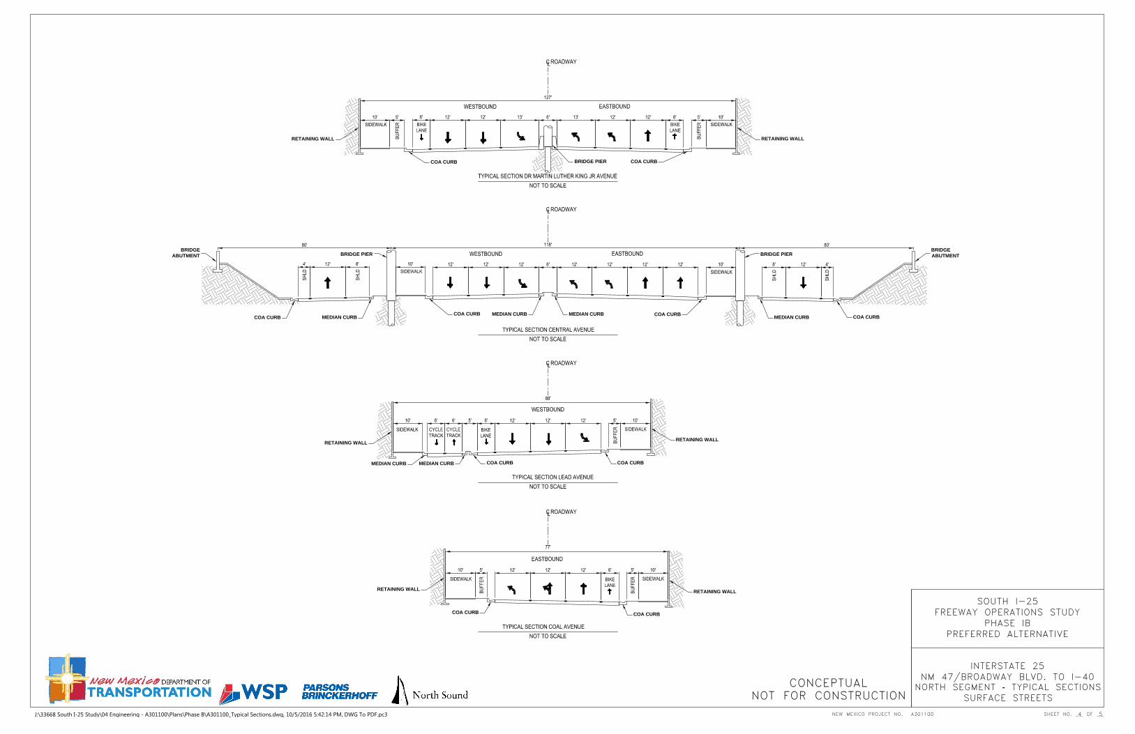
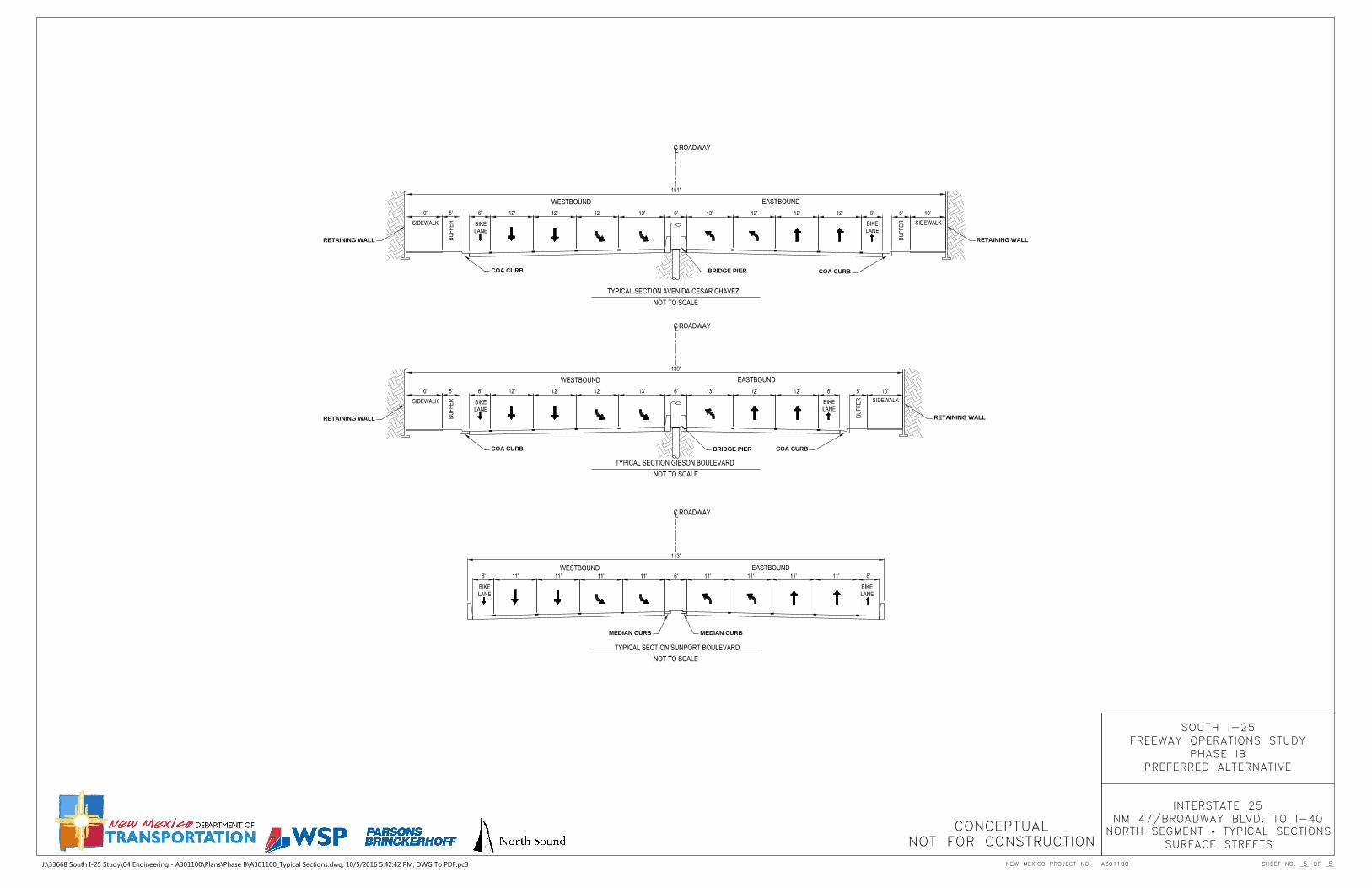
J:\33668 South I-25 Study\04 Engineering - A301100\Plans\Phase B\A301100_Typical Sections.dwg, 10/5/2016 5:42:14 PM, DWG To PDF.pc3
COA CURBCOA CURB
RETAINING WALL
RETAINING WALL
BRIDGE PIER
MEDIAN CURB MEDIAN CURB
COA CURB
COA CURB
RETAINING WALLRETAINING WALL
BRIDGE PIER
NEW MEXICO PROJECT NO. SHEET NO.
CONCEPTUALNOT FOR CONSTRUCTION
SOUTH I-25FREEWAY OPERATIONS STUDY
PHASE IBPREFERRED ALTERNATIVE
INTERSTATE 25NM 47/BROADWAY BLVD. TO I-40
5 5
NORTH SEGMENT - TYPICAL SECTIONSSURFACE STREETS
J:\33668 South I-25 Study\04 Engineering - A301100\Plans\Phase B\A301100_Typical Sections.dwg, 10/5/2016 5:42:42 PM, DWG To PDF.pc3

6 1 0 0 U p t o w n B o u l e v a r d , S u i t e 7 0 06 1 0 0 U p t o w n B o u l e v a r d , S u i t e 7 0 0
A l b u q u e r q u e N M 8 7 1 1 0A l b u q u e r q u e N M 8 7 1 1 0
5 0 5 . 8 8 1 . 5 3 5 75 0 5 . 8 8 1 . 5 3 5 7
5 0 5 . 8 8 1 . 7 6 0 2 f a x5 0 5 . 8 8 1 . 7 6 0 2 f a x
w w w . p b w o r l d . c o mw w w . p b w o r l d . c o m
s u b m i t t e d b y :s u b m i t t e d b y :


![[AGENCY] CONTRACTS AND PROCUREMENT POLICY AND PROCEDURES ...dot.state.nm.us/content/dam/nmdot/Transit_Rail/ProcurementManual... · [agency] contracts and procurement policy and procedures](https://static.fdocuments.net/doc/165x107/5ae0bbb27f8b9a6e5c8dd48a/agency-contracts-and-procurement-policy-and-procedures-dotstatenmuscontentdamnmdottransitrailprocurementmanualagency.jpg)