ARCHAEOLOGICAL DATA RECOVERY AT THREE...
291
-
Upload
duongxuyen -
Category
Documents
-
view
214 -
download
0
Transcript of ARCHAEOLOGICAL DATA RECOVERY AT THREE...
ARCHAEOLOGICAL DATA RECOVERY AT THREE SITESALONG US 64, EAST OF LUMBERTON,RIO ARRIBA COUNTY, NEW MEXICO
Submitted to:
NEW MEXICO DEPARTMENT OF TRANSPORTATIONCultural Resources Bureau, Environmental Design Division
1120 Cerrillos RoadSanta Fe, New Mexico 87505-1842
Submitted by:
FOUR CORNERS RESEARCHP.O. Box 1265
Tularosa, New Mexico 88352
Prepared by:
David H. Greenwald, Peter L. Eidenbach,Tim M. Mills, and Lindsay R. Poitevint
with contributions by:Heather R. Blanton
Dawn M. GreenwaldStephen A. HallDean C. Wilson
NMDOT Project Number AC-GRIP-(TMP)-064-4(28)142, G2775FOUR CORNERS RESEARCH REPORT No. 278-4-2
Cultural Resources Permit No. 09-122Historic Preservation Division Project-Specific Permit SE-265
NMCRIS No. 113921
September 28, 2009
iii
TABLE OF CONTENTS
1.0 PROJECT SCOPE AND SETTING, by David H. Greenwald . . . . . . . . . . . . . . . . . . . . 1.11.1 Sub-Task I: Project Administration and Development of Research Design
and Plan of Work . . . . . . . . . . . . . . . . . . . . . . . . . . . . . . . . . . . . . . . . . . . . . . . . 1.11.2 Sub-Task II: Field Investigations at Sites LA 1330205, LA 133206, and
LA 155234 . . . . . . . . . . . . . . . . . . . . . . . . . . . . . . . . . . . . . . . . . . . . . . . . . . . . . . 1.11.3 Sub-Task III: Analysis and Report of Findings . . . . . . . . . . . . . . . . . . . . . . . . . 1.31.4 Sub-Task IV: Curation and Project Deliverables . . . . . . . . . . . . . . . . . . . . . . . . 1.41.5 Relevant Background Information . . . . . . . . . . . . . . . . . . . . . . . . . . . . . . . . . . . 1.41.6 Physical and Environmental Setting, by Tim M. Mills . . . . . . . . . . . . . . . . . . . . 1.6
1.6.1 Topography . . . . . . . . . . . . . . . . . . . . . . . . . . . . . . . . . . . . . . . . . . . . . . . . 1.61.6.2 Climate . . . . . . . . . . . . . . . . . . . . . . . . . . . . . . . . . . . . . . . . . . . . . . . . . . . . 1.71.6.3 Flora and Fauna . . . . . . . . . . . . . . . . . . . . . . . . . . . . . . . . . . . . . . . . . . . . . 1.8
1.7 Cultural Setting and Historic Context, by Peter L. Eidenbach . . . . . . . . . . . . . 1.8
2.0 SUMMARY OF THE CULTURE HISTORY OF THE LUMBERTON AREA,by Peter L. Eidenbach and David H. Greenwald . . . . . . . . . . . . . . . . . . . . . . . . . . . . . . . 2.1
2.1 The Paleoindian Period . . . . . . . . . . . . . . . . . . . . . . . . . . . . . . . . . . . . . . . . . . . . . 2.12.2 The Archaic Period . . . . . . . . . . . . . . . . . . . . . . . . . . . . . . . . . . . . . . . . . . . . . . . . 2.32.3 The Ceramic Period . . . . . . . . . . . . . . . . . . . . . . . . . . . . . . . . . . . . . . . . . . . . . . . . 2.42.4 Protohistoric/Historic Native American Period . . . . . . . . . . . . . . . . . . . . . . . . . 2.62.5 Historic Period . . . . . . . . . . . . . . . . . . . . . . . . . . . . . . . . . . . . . . . . . . . . . . . . . . . . 2.7
2.5.1 Spanish Period and Native American Interaction (A.D. 1540-1821) . . . 2.72.5.2 Mexican Period (1821–1846) . . . . . . . . . . . . . . . . . . . . . . . . . . . . . . . . . . . 2.92.5.3 American Period (1846–present) . . . . . . . . . . . . . . . . . . . . . . . . . . . . . . 2.12
3.0 RESEARCH DESIGN, by David H. Greenwald and Peter L. Eidenbach . . . . . . . . . . . 3.13.1 Problem Domain 1: Cultural Temporal Affiliations . . . . . . . . . . . . . . . . . . . . . 3.1
3.1.1 Research Questions . . . . . . . . . . . . . . . . . . . . . . . . . . . . . . . . . . . . . . . . . . 3.23.1.2 Data Requirements . . . . . . . . . . . . . . . . . . . . . . . . . . . . . . . . . . . . . . . . . . 3.3
3.2 Problem Domain 2: Subsistence and Economy . . . . . . . . . . . . . . . . . . . . . . . . . . 3.43.2.1 Research Questions . . . . . . . . . . . . . . . . . . . . . . . . . . . . . . . . . . . . . . . . . . 3.43.2.2 Data Requirements . . . . . . . . . . . . . . . . . . . . . . . . . . . . . . . . . . . . . . . . . . 3.5
3.3 Problem Domain 3: Land-Use Strategies . . . . . . . . . . . . . . . . . . . . . . . . . . . . . . . 3.63.3.1 Research Questions . . . . . . . . . . . . . . . . . . . . . . . . . . . . . . . . . . . . . . . . . . 3.73.3.2 Data Requirements . . . . . . . . . . . . . . . . . . . . . . . . . . . . . . . . . . . . . . . . . . 3.7
3.4 Problem Domain 4: Geomorphological Associations and Implications . . . . . . 3.83.4.1 Research Questions . . . . . . . . . . . . . . . . . . . . . . . . . . . . . . . . . . . . . . . . . . 3.83.4.2 Data Requirements . . . . . . . . . . . . . . . . . . . . . . . . . . . . . . . . . . . . . . . . . . 3.9
3.5 Problem Domain 5: Historic Aboriginal vs. Euroamerican . . . . . . . . . . . . . . . . 3.93.5.1 Research Questions . . . . . . . . . . . . . . . . . . . . . . . . . . . . . . . . . . . . . . . . . . 3.93.5.2 Data Requirements . . . . . . . . . . . . . . . . . . . . . . . . . . . . . . . . . . . . . . . . . 3.10
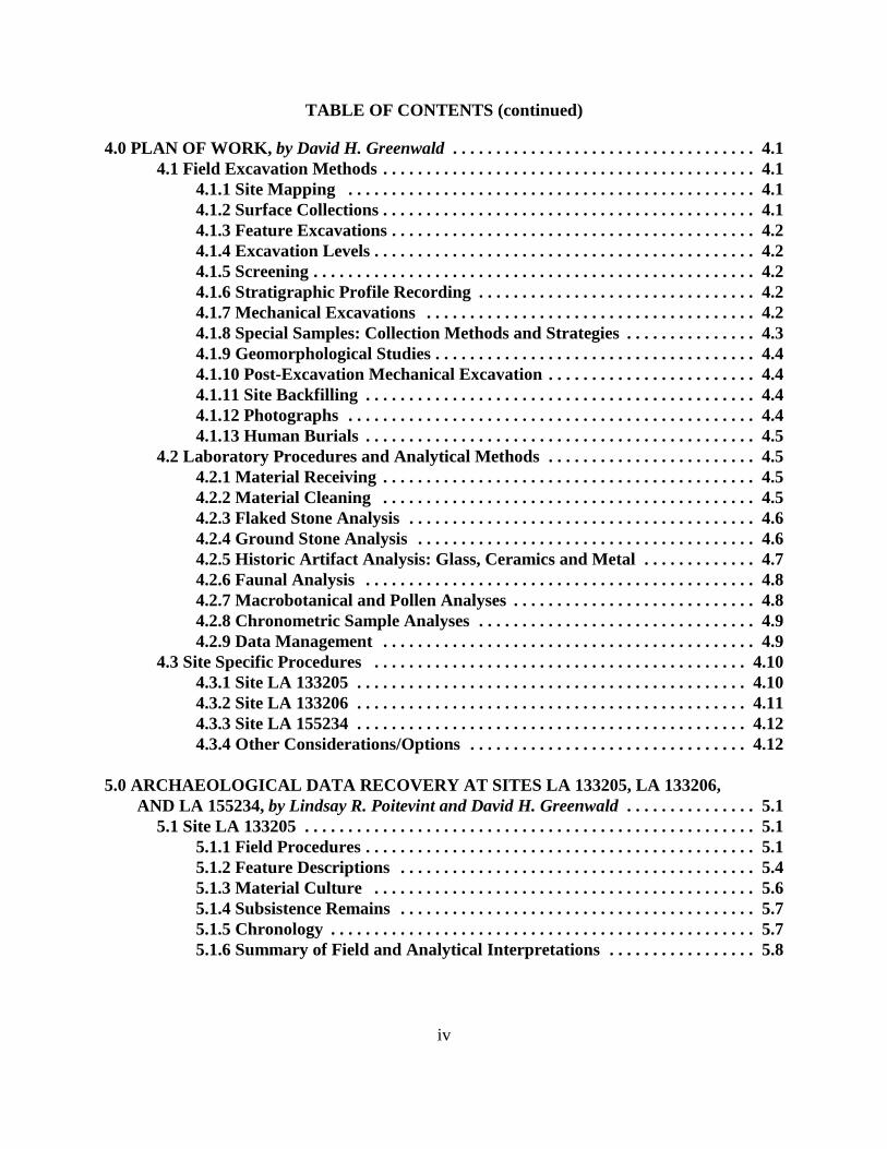
TABLE OF CONTENTS (continued)
iv
4.0 PLAN OF WORK, by David H. Greenwald . . . . . . . . . . . . . . . . . . . . . . . . . . . . . . . . . . . 4.14.1 Field Excavation Methods . . . . . . . . . . . . . . . . . . . . . . . . . . . . . . . . . . . . . . . . . . . 4.1
4.1.1 Site Mapping . . . . . . . . . . . . . . . . . . . . . . . . . . . . . . . . . . . . . . . . . . . . . . . 4.14.1.2 Surface Collections . . . . . . . . . . . . . . . . . . . . . . . . . . . . . . . . . . . . . . . . . . . 4.14.1.3 Feature Excavations . . . . . . . . . . . . . . . . . . . . . . . . . . . . . . . . . . . . . . . . . . 4.24.1.4 Excavation Levels . . . . . . . . . . . . . . . . . . . . . . . . . . . . . . . . . . . . . . . . . . . . 4.24.1.5 Screening . . . . . . . . . . . . . . . . . . . . . . . . . . . . . . . . . . . . . . . . . . . . . . . . . . . 4.24.1.6 Stratigraphic Profile Recording . . . . . . . . . . . . . . . . . . . . . . . . . . . . . . . . 4.24.1.7 Mechanical Excavations . . . . . . . . . . . . . . . . . . . . . . . . . . . . . . . . . . . . . . 4.24.1.8 Special Samples: Collection Methods and Strategies . . . . . . . . . . . . . . . 4.34.1.9 Geomorphological Studies . . . . . . . . . . . . . . . . . . . . . . . . . . . . . . . . . . . . . 4.44.1.10 Post-Excavation Mechanical Excavation . . . . . . . . . . . . . . . . . . . . . . . . 4.44.1.11 Site Backfilling . . . . . . . . . . . . . . . . . . . . . . . . . . . . . . . . . . . . . . . . . . . . . 4.44.1.12 Photographs . . . . . . . . . . . . . . . . . . . . . . . . . . . . . . . . . . . . . . . . . . . . . . . 4.44.1.13 Human Burials . . . . . . . . . . . . . . . . . . . . . . . . . . . . . . . . . . . . . . . . . . . . . 4.5
4.2 Laboratory Procedures and Analytical Methods . . . . . . . . . . . . . . . . . . . . . . . . 4.54.2.1 Material Receiving . . . . . . . . . . . . . . . . . . . . . . . . . . . . . . . . . . . . . . . . . . . 4.54.2.2 Material Cleaning . . . . . . . . . . . . . . . . . . . . . . . . . . . . . . . . . . . . . . . . . . . 4.54.2.3 Flaked Stone Analysis . . . . . . . . . . . . . . . . . . . . . . . . . . . . . . . . . . . . . . . . 4.64.2.4 Ground Stone Analysis . . . . . . . . . . . . . . . . . . . . . . . . . . . . . . . . . . . . . . . 4.64.2.5 Historic Artifact Analysis: Glass, Ceramics and Metal . . . . . . . . . . . . . 4.74.2.6 Faunal Analysis . . . . . . . . . . . . . . . . . . . . . . . . . . . . . . . . . . . . . . . . . . . . . 4.84.2.7 Macrobotanical and Pollen Analyses . . . . . . . . . . . . . . . . . . . . . . . . . . . . 4.84.2.8 Chronometric Sample Analyses . . . . . . . . . . . . . . . . . . . . . . . . . . . . . . . . 4.94.2.9 Data Management . . . . . . . . . . . . . . . . . . . . . . . . . . . . . . . . . . . . . . . . . . . 4.9
4.3 Site Specific Procedures . . . . . . . . . . . . . . . . . . . . . . . . . . . . . . . . . . . . . . . . . . . 4.104.3.1 Site LA 133205 . . . . . . . . . . . . . . . . . . . . . . . . . . . . . . . . . . . . . . . . . . . . . 4.104.3.2 Site LA 133206 . . . . . . . . . . . . . . . . . . . . . . . . . . . . . . . . . . . . . . . . . . . . . 4.114.3.3 Site LA 155234 . . . . . . . . . . . . . . . . . . . . . . . . . . . . . . . . . . . . . . . . . . . . . 4.124.3.4 Other Considerations/Options . . . . . . . . . . . . . . . . . . . . . . . . . . . . . . . . 4.12
5.0 ARCHAEOLOGICAL DATA RECOVERY AT SITES LA 133205, LA 133206, AND LA 155234, by Lindsay R. Poitevint and David H. Greenwald . . . . . . . . . . . . . . . 5.1
5.1 Site LA 133205 . . . . . . . . . . . . . . . . . . . . . . . . . . . . . . . . . . . . . . . . . . . . . . . . . . . . 5.15.1.1 Field Procedures . . . . . . . . . . . . . . . . . . . . . . . . . . . . . . . . . . . . . . . . . . . . . 5.15.1.2 Feature Descriptions . . . . . . . . . . . . . . . . . . . . . . . . . . . . . . . . . . . . . . . . . 5.45.1.3 Material Culture . . . . . . . . . . . . . . . . . . . . . . . . . . . . . . . . . . . . . . . . . . . . 5.65.1.4 Subsistence Remains . . . . . . . . . . . . . . . . . . . . . . . . . . . . . . . . . . . . . . . . . 5.75.1.5 Chronology . . . . . . . . . . . . . . . . . . . . . . . . . . . . . . . . . . . . . . . . . . . . . . . . . 5.75.1.6 Summary of Field and Analytical Interpretations . . . . . . . . . . . . . . . . . 5.8
TABLE OF CONTENTS (continued)
v
5.2 Site LA 133206 . . . . . . . . . . . . . . . . . . . . . . . . . . . . . . . . . . . . . . . . . . . . . . . . . . . . 5.85.2.1 Field Procedures . . . . . . . . . . . . . . . . . . . . . . . . . . . . . . . . . . . . . . . . . . . . 5.105.2.2 Feature Descriptions . . . . . . . . . . . . . . . . . . . . . . . . . . . . . . . . . . . . . . . . 5.135.2.3 Material Culture . . . . . . . . . . . . . . . . . . . . . . . . . . . . . . . . . . . . . . . . . . . 5.195.2.4 Subsistence Remains . . . . . . . . . . . . . . . . . . . . . . . . . . . . . . . . . . . . . . . . 5.215.2.5 Chronology . . . . . . . . . . . . . . . . . . . . . . . . . . . . . . . . . . . . . . . . . . . . . . . . 5.225.2.6 Summary of Field and Analytical Interpretations . . . . . . . . . . . . . . . . 5.23
5.3 Site LA 155234 . . . . . . . . . . . . . . . . . . . . . . . . . . . . . . . . . . . . . . . . . . . . . . . . . . . 5.235.3.1 Field Procedures . . . . . . . . . . . . . . . . . . . . . . . . . . . . . . . . . . . . . . . . . . . . 5.255.3.2 Feature Descriptions . . . . . . . . . . . . . . . . . . . . . . . . . . . . . . . . . . . . . . . . 5.285.3.3 Material Culture . . . . . . . . . . . . . . . . . . . . . . . . . . . . . . . . . . . . . . . . . . . 5.305.3.4 Subsistence Remains . . . . . . . . . . . . . . . . . . . . . . . . . . . . . . . . . . . . . . . . 5.325.3.5 Chronology . . . . . . . . . . . . . . . . . . . . . . . . . . . . . . . . . . . . . . . . . . . . . . . . 5.335.3.6 Summary of Field and Analytical Interpretations . . . . . . . . . . . . . . . . 5.34
6.0 ARTIFACT ANALYSES . . . . . . . . . . . . . . . . . . . . . . . . . . . . . . . . . . . . . . . . . . . . . . . . . 6.16.1 Ceramic Analysis, by Dean C. Wilson and David H. Greenwald . . . . . . . . . . . . 6.16.2 Flaked and Ground Stone Analyses, by Dawn M. Greenwald . . . . . . . . . . . . . . 6.2
6.2.1 Flaked Stone Analysis . . . . . . . . . . . . . . . . . . . . . . . . . . . . . . . . . . . . . . . . 6.26.2.2 Ground Stone Analysis . . . . . . . . . . . . . . . . . . . . . . . . . . . . . . . . . . . . . . 6.136.2.3 Problem Domains . . . . . . . . . . . . . . . . . . . . . . . . . . . . . . . . . . . . . . . . . . 6.176.2.4 Summary . . . . . . . . . . . . . . . . . . . . . . . . . . . . . . . . . . . . . . . . . . . . . . . . . 6.28
6.3 Historic Artifact Analyses: Glass, Ceramics and Metal,by Heather R. Blanton . . . . . . . . . . . . . . . . . . . . . . . . . . . . . . . . . . . . . . . . . . . . 6.296.3.1 Glass Artifacts from Site LA 133206 . . . . . . . . . . . . . . . . . . . . . . . . . . . 6.306.3.2 Glass Artifacts from Site LA 155234 . . . . . . . . . . . . . . . . . . . . . . . . . . . 6.336.3.3 Euroamerican Ceramics from Site LA 133206 . . . . . . . . . . . . . . . . . . 6.346.3.4 Metal Artifacts from Site LA 133206 . . . . . . . . . . . . . . . . . . . . . . . . . . 6.346.3.5 Metal Artifacts from Site LA 155234 . . . . . . . . . . . . . . . . . . . . . . . . . . 6.356.3.6 Summary of the Historic Artifact Function . . . . . . . . . . . . . . . . . . . . . 6.36
7.0 POLLEN, STARCH, AND MACROFLORAL ANALYSES FOR SITES LA 133205,LA 133206, AND LA 155234 ALONG HIGHWAY 64, NORTHWESTERN NEWMEXICO, by Linda Scott Cummings and Kathryn Puseman . . . . . . . . . . . . . . . . . . . . . 7.1
7.1 Introduction . . . . . . . . . . . . . . . . . . . . . . . . . . . . . . . . . . . . . . . . . . . . . . . . . . . . . . 7.17.2 Methods . . . . . . . . . . . . . . . . . . . . . . . . . . . . . . . . . . . . . . . . . . . . . . . . . . . . . . . . . . 7.1
7.2.1 Pollen . . . . . . . . . . . . . . . . . . . . . . . . . . . . . . . . . . . . . . . . . . . . . . . . . . . . . . 7.17.2.2 Macrofloral . . . . . . . . . . . . . . . . . . . . . . . . . . . . . . . . . . . . . . . . . . . . . . . . . 7.2
7.3 Ethnobotanical Review . . . . . . . . . . . . . . . . . . . . . . . . . . . . . . . . . . . . . . . . . . . . . 7.37.3.1 Native Plants . . . . . . . . . . . . . . . . . . . . . . . . . . . . . . . . . . . . . . . . . . . . . . . . 7.47.3.2 Charcoal . . . . . . . . . . . . . . . . . . . . . . . . . . . . . . . . . . . . . . . . . . . . . . . . . . . 7.5
TABLE OF CONTENTS (continued)
vi
7.4 Discussion . . . . . . . . . . . . . . . . . . . . . . . . . . . . . . . . . . . . . . . . . . . . . . . . . . . . . . . . 7.87.4.1 Site LA 133205 . . . . . . . . . . . . . . . . . . . . . . . . . . . . . . . . . . . . . . . . . . . . . . 7.97.4.2 Site LA 133206 . . . . . . . . . . . . . . . . . . . . . . . . . . . . . . . . . . . . . . . . . . . . . 7.177.4.3 Site LA 155234 . . . . . . . . . . . . . . . . . . . . . . . . . . . . . . . . . . . . . . . . . . . . . 7.20
7.5 Summary and Conclusions . . . . . . . . . . . . . . . . . . . . . . . . . . . . . . . . . . . . . . . . . 7.22
8.0 FAUNAL ANALYSIS FOR THE US 64 DATA RECOVERY PROJECT,by Kathy Roller Durand, Ph.D. . . . . . . . . . . . . . . . . . . . . . . . . . . . . . . . . . . . . . . . . . . . . . 8.1
8.1 Methods Used . . . . . . . . . . . . . . . . . . . . . . . . . . . . . . . . . . . . . . . . . . . . . . . . . . . . . 8.18.1.1 Site LA 133205 . . . . . . . . . . . . . . . . . . . . . . . . . . . . . . . . . . . . . . . . . . . . . . 8.18.1.2 Site LA 133206 . . . . . . . . . . . . . . . . . . . . . . . . . . . . . . . . . . . . . . . . . . . . . . 8.28.1.3 Site LA 155234 . . . . . . . . . . . . . . . . . . . . . . . . . . . . . . . . . . . . . . . . . . . . . . 8.3
8.2 Summary . . . . . . . . . . . . . . . . . . . . . . . . . . . . . . . . . . . . . . . . . . . . . . . . . . . . . . . . . 8.4
9.0 GEOMORPHOLOGY OF SITES LA 133205, LA 133206, AND LA 155234 ALONGUS HIGHWAY 64, NORTHWESTERN NEW MEXICO, by Stephen A. Hall . . . . . . 9.1
9.1 Bedrock Geology . . . . . . . . . . . . . . . . . . . . . . . . . . . . . . . . . . . . . . . . . . . . . . . . . . 9.19.2 Archaeological Geology . . . . . . . . . . . . . . . . . . . . . . . . . . . . . . . . . . . . . . . . . . . . . 9.2
9.2.1 Site LA 133205 . . . . . . . . . . . . . . . . . . . . . . . . . . . . . . . . . . . . . . . . . . . . . . 9.29.2.2 Site LA 133206 . . . . . . . . . . . . . . . . . . . . . . . . . . . . . . . . . . . . . . . . . . . . . . 9.49.2.3 site LA 155234 . . . . . . . . . . . . . . . . . . . . . . . . . . . . . . . . . . . . . . . . . . . . . . 9.8
9.3 Summary and Conclusions . . . . . . . . . . . . . . . . . . . . . . . . . . . . . . . . . . . . . . . . . 9.11
10.0 SITE CHRONOLOGY AND DATA IMPLICATIONS, by David H. Greenwaldand Peter L. Eidenbach . . . . . . . . . . . . . . . . . . . . . . . . . . . . . . . . . . . . . . . . . . . . . . . . . 10.1
10.1 Radiocarbon Dating . . . . . . . . . . . . . . . . . . . . . . . . . . . . . . . . . . . . . . . . . . . . . . 10.110.1.1 Site LA 133205 . . . . . . . . . . . . . . . . . . . . . . . . . . . . . . . . . . . . . . . . . . . . 10.110.1.2 Site LA 133206 . . . . . . . . . . . . . . . . . . . . . . . . . . . . . . . . . . . . . . . . . . . . 10.110.1.3 Site LA 155234 . . . . . . . . . . . . . . . . . . . . . . . . . . . . . . . . . . . . . . . . . . . . 10.2
10.2 Temporal Implications of the Artifact Assemblages . . . . . . . . . . . . . . . . . . . 10.210.2.1 Site LA 133205 . . . . . . . . . . . . . . . . . . . . . . . . . . . . . . . . . . . . . . . . . . . . 10.210.2.2 Site LA 133206 . . . . . . . . . . . . . . . . . . . . . . . . . . . . . . . . . . . . . . . . . . . . 10.310.2.3 Site LA 155234 . . . . . . . . . . . . . . . . . . . . . . . . . . . . . . . . . . . . . . . . . . . . 10.3
10.3 Obsidian Hydration: A Relative Means of Assessing Temporal Associations . . . . . . . . . . . . . . . . . . . . . . . . . . . . . . . . . . . . . . . . . . . . . . . . . . . . 10.410.3.1 Site LA 133205 . . . . . . . . . . . . . . . . . . . . . . . . . . . . . . . . . . . . . . . . . . . . 10.410.3.2 Site LA 133206 . . . . . . . . . . . . . . . . . . . . . . . . . . . . . . . . . . . . . . . . . . . . 10.410.3.3 Site LA 155234 . . . . . . . . . . . . . . . . . . . . . . . . . . . . . . . . . . . . . . . . . . . . 10.5
10.4 Stratigraphy and Geomorphological Interpretations . . . . . . . . . . . . . . . . . . . 10.510.4.1 Site LA 133205 . . . . . . . . . . . . . . . . . . . . . . . . . . . . . . . . . . . . . . . . . . . . 10.510.4.2 Site LA 133206 . . . . . . . . . . . . . . . . . . . . . . . . . . . . . . . . . . . . . . . . . . . . 10.610.4.3 Site LA 155234 . . . . . . . . . . . . . . . . . . . . . . . . . . . . . . . . . . . . . . . . . . . . 10.6
TABLE OF CONTENTS (continued)
vii
10.5 Archaeomagnetic Sampling . . . . . . . . . . . . . . . . . . . . . . . . . . . . . . . . . . . . . . . 10.710.6 Conclusions and Interpretations . . . . . . . . . . . . . . . . . . . . . . . . . . . . . . . . . . . 10.7
11.0 PROJECT REVIEW AND SUMMARY, by David H. Greenwald andPeter L. Eidenbach . . . . . . . . . . . . . . . . . . . . . . . . . . . . . . . . . . . . . . . . . . . . . . . . . . . . 11.1
11.1 Focus of Research . . . . . . . . . . . . . . . . . . . . . . . . . . . . . . . . . . . . . . . . . . . . . . . 11.111.1.1 Summary of Sites Investigated . . . . . . . . . . . . . . . . . . . . . . . . . . . . . . 11.2
11.2 Evaluation of the Research Design . . . . . . . . . . . . . . . . . . . . . . . . . . . . . . . . 11.1011.2.1 Problem Domain 1: Cultural/Temporal Affiliation . . . . . . . . . . . . . 11.1111.2.2 Problem Domain 2: Subsistence and Economy . . . . . . . . . . . . . . . . 11.1211.2.3 Problem Domain 3: Land-Use Strategies . . . . . . . . . . . . . . . . . . . . . 11.1311.2.4 Geomorphological Associations and Implications . . . . . . . . . . . . . . 11.1511.2.5 Historic Aboriginal vs. Euroamerican Affiliations . . . . . . . . . . . . . 11.15
11.3 Sites in a Regional Context . . . . . . . . . . . . . . . . . . . . . . . . . . . . . . . . . . . . . . . 11.1611.4 Management Recommendations . . . . . . . . . . . . . . . . . . . . . . . . . . . . . . . . . . 11.19
12.0 REFERENCES CITED . . . . . . . . . . . . . . . . . . . . . . . . . . . . . . . . . . . . . . . . . . . . . . . . 12.1
APPENDIX A: LOCATIONAL MAPS . . . . . . . . . . . . . . . . . . . . . . . . . . . . . . . . . . . . . . . . A.1
APPENDIX B: RADIOCARBON DATING ANALYSIS,by Beta Analytic, Inc. . . . . . . . . . . . . . . . . . . . . . . . . . . . . . . . . . . . . . . . . . . . . . . . . . . . . . . . B.1
APPENDIX C: OBSIDIAN HYDRATION BAND ANALYSIS, by Origer’s Obsidian Laboratory . . . . . . . . . . . . . . . . . . . . . . . . . . . . . . . . . . . . . . . . . . . . . . C.1
APPENDIX D: ARCHAEOMAGNETIC DATING REPORT FOR SITE LA 133206, by J. Royce Cox, Archaeomagnetic Dating Laboratory, Museum of New Mexico . . . . . . . D.1
APPENDIX E: FAUNAL ANALYSIS TABLE AND CODING KEY . . . . . . . . . . . . . . . . E.1
APPENDIX F: ENERGY DISPERSIVE X-RAY FLOURESCENCE (EDXRF)ANALYSIS, by Geochemical Research Laboratory . . . . . . . . . . . . . . . . . . . . . . . . . . . . . . . F.1
APPENDIX G: LIST AND DESCRIPTIONS OF COLLECTIONS . . . . . . . . . . . . . . . . G.1
viii
LIST OF FIGURES
Figure 1.1 Project area location for data recovery at three sites along US Highway 64 1.2Figure 1.2 Late May snowfall in the project area . . . . . . . . . . . . . . . . . . . . . . . . . . . . . . . 1.7Figure 2.1 Chronology of Northern New Mexico . . . . . . . . . . . . . . . . . . . . . . . . . . . . . . . 2.2Figure 2.2 The first modern map of the Southwest, compiled by Baron Alexander
von Humboldt in 1803 and published in 1811 . . . . . . . . . . . . . . . . . . . . . . . 2.10Figure 2.3 Pike’s 1810 map of his expedition to the Internal Provinces of New Spain
(northwestern New Mexico) was copied from Humboldt’s manuscriptmap of 1803 . . . . . . . . . . . . . . . . . . . . . . . . . . . . . . . . . . . . . . . . . . . . . . . . . . . 2.11
Figure 2.4 Portion of Warren’s 1857(1858?) Topographic Engineer map, whichidentified the area of Menuaches/Muhuaches Indians (Utes) in theChama/Dulce vicinity . . . . . . . . . . . . . . . . . . . . . . . . . . . . . . . . . . . . . . . . . . . 2.13
Figure 2.5 The 1866 General Land Office map, noting the area of the “Utahs” (Utes)in the vicinity of the project area . . . . . . . . . . . . . . . . . . . . . . . . . . . . . . . . . 2.15
Figure 5.1 Plan map of Site LA 133205 . . . . . . . . . . . . . . . . . . . . . . . . . . . . . . . . . . . . . . . . 5.2Figure 5.2 South profile of 4 x 4-m hand stripping unit at Feature 3, Site LA 133205,
showing the tan, brown, and gray layers of lignite-enriched sediments . . . 5.5Figure 5.3 Plan map of Site LA 133206, in U.S. 64 right-of-way acquired from
private sources . . . . . . . . . . . . . . . . . . . . . . . . . . . . . . . . . . . . . . . . . . . . . . . . . 5.9Figure 5.4. Work in progress at Site LA 133206 . . . . . . . . . . . . . . . . . . . . . . . . . . . . . . . . 5.13Figure 5.5 Feature 7, Site LA 133206, post excavation . . . . . . . . . . . . . . . . . . . . . . . . . . 5.16Figure 5.6 Site LA 133206, showing (a) plan view and (b) cross section of Feature 8 . 5.17Figure 5.7 Plan map of Site LA 155234 . . . . . . . . . . . . . . . . . . . . . . . . . . . . . . . . . . . . . . . 5.24Figure 5.8 Clearing sagebrush at Site LA 155234 . . . . . . . . . . . . . . . . . . . . . . . . . . . . . . 5.25Figure 6.1 Projectile points: (a) Site LA 133206; (b) Site LA 155234;
(c) Site LA 155234; (d) Site LA 155234 . . . . . . . . . . . . . . . . . . . . . . . . . . . . 6.11Figure 6.2 Late Archaic period projectile points: Site LA 133206;
(b) Site LA 155234; (c) Site LA 155234; (d) Site LA 155234 . . . . . . . . . . . 6.19Figure 6.3 Location of project area in relation to northern New Mexico obsidian
sources . . . . . . . . . . . . . . . . . . . . . . . . . . . . . . . . . . . . . . . . . . . . . . . . . . . . . . 6.27Figure 7.1 Pollen diagram for Sites LA 133205, LA 133206, and LA 155234 . . . . . . . . 7.11Figure 9.1 Geologic map of area with three archaeological sites along US Highway 64
between Chama and Dulce, Rio Arriba County, NM . . . . . . . . . . . . . . . . . . 9.1Figure 9.2 Site LA 133205 occurs on weathered Cretaceous shale; the colluvial cover
occurs as discontinuous pockets of sediment and is a mix of slope washand eolian fine sand and silt . . . . . . . . . . . . . . . . . . . . . . . . . . . . . . . . . . . . . . 9.2
Figure 9.3 This zone of colluvium overlying weathered shale at Site LA 133205 . . . . . . 9.3Figure 9.4 Weathered Cretaceous shale exposed in test at Site LA 133205 . . . . . . . . . . . 9.3Figure 9.5 Recent burrowing activity into weathered Cretaceous shale on north side
of US Highway 64 at Site LA 133205 . . . . . . . . . . . . . . . . . . . . . . . . . . . . . . . 9.4Figure 9.6 Road cut along Site LA 133206 along US Highway 64, showing Cretaceous
shale and thin mantle of Holocene colluvium . . . . . . . . . . . . . . . . . . . . . . . . 9.5
ix
LIST OF FIGURES (continued)
Figure 9.7 Exposed fill from twentieth-century drainage ditch on road cut above US Highway 64 at Site LA 133206 . . . . . . . . . . . . . . . . . . . . . . . . . . . . . . . . . 9.5
Figure 9.8 Small scraped area on north side of highway at LA 133206, exposing weathered Cretaceous shale . . . . . . . . . . . . . . . . . . . . . . . . . . . . . . . . . . . . . . 9.6
Figure 9.9 Recent colluvial sediments overlying Cretaceous shale at Site LA 133206,exposed at top edge of road cut . . . . . . . . . . . . . . . . . . . . . . . . . . . . . . . . . . . 9.6
Figure 9.10 Close-up of Holocene colluvium overlying Cretaceous shale,Site LA 133206 . . . . . . . . . . . . . . . . . . . . . . . . . . . . . . . . . . . . . . . . . . . . . . . . . 9.7
Figure 9.11 Unusually thick section of colluvium with weak A horizon soil at SiteLA 133206 . . . . . . . . . . . . . . . . . . . . . . . . . . . . . . . . . . . . . . . . . . . . . . . . . . . . 9.7
Figure 9.12 A comparatively thick section of colluvium at Site LA 133206, with an A horizon soil . . . . . . . . . . . . . . . . . . . . . . . . . . . . . . . . . . . . . . . . . . . . . . . . . . 9.8
Figure 9.13 Upslope from Site LA 155234, showing sandstone blocks and pebblesfrom escarpment outcrop at top of ridge . . . . . . . . . . . . . . . . . . . . . . . . . . . . 9.9
Figure 9.14 Close-up of colluvial Cretaceous sandstone pebbles upslope from Site LA 155234 . . . . . . . . . . . . . . . . . . . . . . . . . . . . . . . . . . . . . . . . . . . . . . . . . . . . . 9.9
Figure 9.15 Trench at Site LA 155234, exposing Cretaceous shale and lignite . . . . . . . . 9.10Figure 9.16 Exposures of Cretaceous shale and lignite at Site LA 155234 with thin,
discontinuous pockets of recent slope-wash colluvium . . . . . . . . . . . . . . . 9.10Figure 9.17 Exposures of pockets of thicker recent colluvial sediments in which
artifacts occur at Site LA 155234 . . . . . . . . . . . . . . . . . . . . . . . . . . . . . . . . . 9.11Figure 11.1 Possible prehistoric routes used for procurement of obsidian and
clay resources. . . . . . . . . . . . . . . . . . . . . . . . . . . . . . . . . . . . . . . . . . . . . . . . 11.14
LIST OF TABLES
Table 5.1 Description of Excavations of Control Units 1-3, Site LA 133205 . . . . . . . . . 5.3Table 5.2 Description of Excavations of Control Units 1-8, Site LA 133206 . . . . . . . . 5.11Table 5.3 Description of Excavations of Control Units 1-7, Site LA 155234 . . . . . . . . 5.26Table 6.1 Ceramic Vessel Part . . . . . . . . . . . . . . . . . . . . . . . . . . . . . . . . . . . . . . . . . . . . . . 6.1Table 6.2 Flaked Stone Artifact Type by Site . . . . . . . . . . . . . . . . . . . . . . . . . . . . . . . . . 6.3Table 6.3 Flaked Stone Material Type by Site . . . . . . . . . . . . . . . . . . . . . . . . . . . . . . . . . 6.5Table 6.4 Flaked Stone Debitage Attributes by Site . . . . . . . . . . . . . . . . . . . . . . . . . . . . 6.9Table 6.5 Ground Stone Artifact Type by Site . . . . . . . . . . . . . . . . . . . . . . . . . . . . . . . . 6.16Table 6.6 Glass Frequencies by Color/Part from Site LA 133206 . . . . . . . . . . . . . . . . 6.30Table 6.7 Frequency of Glass Artifact Forms from Site LA 133206 . . . . . . . . . . . . . . 6.31Table 6.8 Temporal Range of Production of Glass Colors . . . . . . . . . . . . . . . . . . . . . . 6.32Table 6.9 Frequencies of Historic Ceramic Type/Parts from Site LA 133206 . . . . . . 6.34Table 6.10 Frequencies of Metal Artifacts at Site LA 133206 . . . . . . . . . . . . . . . . . . . . 6.35Table 7.1 Provenience Data for Samples from Sites LA 133205, LA 133206, and
LA 155234 . . . . . . . . . . . . . . . . . . . . . . . . . . . . . . . . . . . . . . . . . . . . . . . . . . . . 7.10
x
LIST OF TABLES (continued)
Table 7.2 Pollen Types Observed in Samples from Sites LA 133205, LA 133206 andLA 155234 . . . . . . . . . . . . . . . . . . . . . . . . . . . . . . . . . . . . . . . . . . . . . . . . . . . . 7.12
Table 7.3 Macrofloral Remains from Site LA 133205 . . . . . . . . . . . . . . . . . . . . . . . . . . 7.13Table 7.4 Index of Macrofloral Remains Recovered from Sites LA 133205,
LA 133206, and LA 155234 . . . . . . . . . . . . . . . . . . . . . . . . . . . . . . . . . . . . . . 7.15Table 7.5 Macrofloral Remains from Site LA 133206 . . . . . . . . . . . . . . . . . . . . . . . . . . 7.18Table 7.6 Macrofloral Remains from Site LA 155234 . . . . . . . . . . . . . . . . . . . . . . . . . . 7.21Table 8.1 Site LA 133205 Faunal Remains . . . . . . . . . . . . . . . . . . . . . . . . . . . . . . . . . . . . 8.2Table 8.2 Site LA 133206 Faunal Remains . . . . . . . . . . . . . . . . . . . . . . . . . . . . . . . . . . . . 8.3Table 8.3 Site LA 155234 Faunal Remains . . . . . . . . . . . . . . . . . . . . . . . . . . . . . . . . . . . . 8.3Table 10.1 Chronological Barchart Showing the Various Temporal Ranges of Glass
Production . . . . . . . . . . . . . . . . . . . . . . . . . . . . . . . . . . . . . . . . . . . . . . . . . . . 10.3Table 10.2 Temporal Implications and Associations of the Artifact Assemblages,
Radiometric Dates, and Obsidian Hydration Rind Thicknesses fromSites LA 133205, LA 133206, and LA 155234 . . . . . . . . . . . . . . . . . . . . . . . 10.7

NMCRIS INVESTIGATION ABSTRACT FORM (NIAF) 1. NMCRIS Activity No.: 113921
2a. Lead (Sponsoring) Agency: New Mexico Department of Transportation (NMDOT)
2b. Other Permitting Agency(ies):
3. Lead Agency Report No.:
4. Title of Report: Archaeological Data Recovery at Three Sites along US 64, East of Lumberton, Rio Arriba County, New Mexico Author(s) David H. Greenwald, Peter L. Eidenbach, Tim M. Mills, and Lindsay R. Poitevint
5. Type of Report Negative Positive
6. Investigation Type Research Design Survey/Inventory Test Excavation Excavation Collections/Non-Field Study Overview/Lit Review Monitoring Ethnographic study Site specific visit Other
8. Dates of Investigation: (from: May 12, 2008 to: June 10, 2008)
7. Description of Undertaking (what does the project entail?): NMDOT proposes to improve a segment of US 64 between Lumberton and US 84, west of Chama, NM. These improvements consist of upgrading and widening of the highway through previously recorded Sites LA 133205 and LA 133206. Previously recorded Site LA 155234 falls within newly acquired right-of-way for the realignment of US 64 at Deadman’s Curve, where construction will completely alter the landscape and remove the site.
9. Report Date: September 28, 2009
11. Performing Agency/Consultant Report No.: 278-4-2 10. Performing Agency/Consultant: DMG Four Corners Research, Inc.
Principal Investigator: David H. Greenwald Field Supervisor: David H. Greenwald Field Personnel Names: Lindsay Poitevint, Tim Mills, Heather Blanton, Justin Greenwald
12. Applicable Cultural Resource Permit No(s): Cultural Resources Permit No. 09-122 HPD Project-Specific Permit No. SE-265
13. Client/Customer (project proponent): NMDOT Contact: Blake Roxlau Address: 1120 Cerrillos Road, Santa Fe, NM 87505-1842 Phone: (505) 827-5224
14. Client/Customer Project No.:
15. Land Ownership Status (Must be indicated on project map): Land Owner Acres Surveyed Acres in APE
NMDOT (acquired from private sources) 0 3
TOTALS 0 3 16 Records Search(es):
Date(s) of ARMS File Review 10-2-2007 Name of Reviewer(s) Dawn Greenwald Four Corners Research Date(s) of NR/SR File Review Name of Reviewer(s) Date(s) of Other Agency File Review Name of Reviewer(s) Agency
NIAF Version 1_7_25_06 1
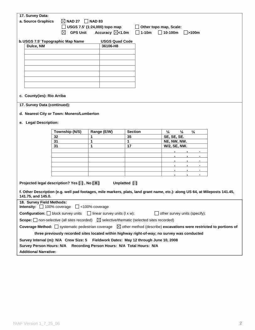
17. Survey Data: a. Source Graphics NAD 27 NAD 83 USGS 7.5’ (1:24,000) topo map Other topo map, Scale: GPS Unit Accuracy <1.0m 1-10m 10-100m >100m b. USGS 7.5' Topographic Map Name USGS Quad Code
Dulce, NM 36106-H8
c. County(ies): Rio Arriba 17. Survey Data (continued): d. Nearest City or Town: Monero/Lumberton e. Legal Description:
Township (N/S) Range (E/W) Section ¼ ¼ ¼ 32 1 35 SE, SE, SE. 31 1 1 NE, NW, NW. 31 1 17 W/2, SE, NW. , , . , , . , , . , , . , , . , , .
Projected legal description? Yes [ ] , No [ X ] Unplatted [ ] f. Other Description (e.g. well pad footages, mile markers, plats, land grant name, etc.): along US 64, at Mileposts 141.45, 141.75, and 145.0. 18. Survey Field Methods: Intensity: 100% coverage <100% coverage
Configuration: block survey units linear survey units (l x w): other survey units (specify):
Scope: non-selective (all sites recorded) selective/thematic (selected sites recorded)
Coverage Method: systematic pedestrian coverage other method (describe) excavations were restricted to portions of
three previously recorded sites located within highway right-of-way; no survey was conducted
Survey Interval (m): N/A Crew Size: 5 Fieldwork Dates: May 12 through June 10, 2008 Survey Person Hours: N/A Recording Person Hours: N/A Total Hours: N/A Additional Narrative:
NIAF Version 1_7_25_06 2

19. Environmental Setting (NRCS soil designation; vegetative community; elevation; etc.): Within the study area, US 64 runs NW to SE in the lower lying terrain between Briggs Mesa and Monero Mountain. Amargo Creek generally parallels the highway on its westward path to Navajo River. Soils are of the Menefee Formation, a component of the Mesa Verde Group, which is a dark-hued carboniferous siltstone or mudstone that accumulated in the deeper portion of a shallow sea interbedded with sandstone, carbonaceous shale, and thin coal beds. They are relatively young and show little evidence of development beyond accumulation of organic matter on their surfaces. Recent colluvial deposits exhibit little profile development and resemble the parent material on which they have formed. Older soils, often visible in the road cuts, exhibit fine-grained, multi-colored argyllic horizons. Three vegetational communities can be distinguished in areas immediately adjacent to the highway. The highest elevations are dominated by Ponderosa Pine-Gambel Oak Series of the Lower Montane Coniferous Forest group; below that vegetation changes to a mixed coniferous woodland dominated by Gamble Oak; and lowest areas on the colluvium, mixed woodlands give way to a mixed savanna of juniper and sage. Species observed on the project include Gambel oak, ponderosa pine, Utah juniper, pinyon pine, chokecherry, fourwing saltbush, three leaf sumac, sand sagebrush, big sagebrush, paintbrush, yarrow, Oregon grape, lupine, evening primrose, larkspur, death camas, and ground daisy. The three sites considered are situated at elevations varying from 2134 to 2286 m (7000 to 7500 ft) amsl. 20. a. Percent Ground Visibility: 26-50% b. Condition of Survey Area (grazed, bladed, undisturbed, etc.): water erosion,
bioturbation, blading, and construction of fence lines and US 64 21. CULTURAL RESOURCE FINDINGS Yes, See Page 3 No, Discuss Why: 22. Required Attachments (check all appropriate boxes):
USGS 7.5 Topographic Map with sites, isolates, and survey area clearly drawn Copy of NMCRIS Mapserver Map Check LA Site Forms - new sites (with sketch map & topographic map) LA Site Forms (update) - previously recorded & un-relocated sites (first 2 pages minimum) Historic Cultural Property Inventory Forms List and Description of isolates, if applicable List and Description of Collections, if applicable
23. Other Attachments:
Photographs and Log Other Attachments
(Describe):
24. I certify the information provided above is correct and accurate and meets all applicable agency standards. Principal Investigator/Responsible Archaeologist:
Signature ___________________________________ Date _June 4, 2009____________ Title (if not PI): 25. Reviewing Agency: Reviewer’s Name/Date Accepted ( ) Rejected ( ) Tribal Consultation (if applicable): Yes No
26. SHPO Reviewer’s Name/Date: HPD Log #: SHPO File Location: Date sent to ARMS:
NIAF Version 1_7_25_06 3

CULTURAL RESOURCE FINDINGS [fill in appropriate section(s)]
1. NMCRIS Activity No.: 113921
2. Lead (Sponsoring) Agency: NMDOT
3. Lead Agency Report No.:
SURVEY RESULTS: Sites discovered and registered: 0 Sites discovered and NOT registered: 0 Previously recorded sites revisited (site update form required): 3 Previously recorded sites not relocated (site update form required): 0 TOTAL SITES VISITED: 3 Total isolates recorded: 0 Non-selective isolate recording? Total structures recorded (new and previously recorded, including acequias): 0 MANAGEMENT SUMMARY: A program of data recovery was conducted to mitigate the effects of upgrading and widening US Highway 64 through previously recorded Sites LA 133205 and LA 133206, and constructing new roadway through previously recorded Site LA 155234. Thee efforts were intensive and implemented under a Project-Specific Permit (SE-265) for New Mexico State Lands (NMDOT right-of-way acquired from private sources) issued by the Department of Cultural Affairs, Historic Preservation Division, April 24, 2008. This report documents the completion of all proposed recovery, analytical, and reporting responsibilities required under the Project-Specific Permit, and fulfills the New Mexico Department of Transportation’s responsibilities in managing these resources in accordance with the current undertaking. Archaeological deposits with integrity remain beyond the south right-of-way boundary at Sites LA 133205 and LA 133206. Updated Laboratory of Anthropology Site Record forms documenting the condition of all three project sites have been completed and submitted with this report. At the request of the Jicarilla Apache Nation and agreed to in a Memorandum of Agreement among the Federal Highway Administration, the NMDOT, and the New Mexico State Historic Preservation Office, discovered artifacts will be reburied on site or adjacent to a site outside the right-of-way. The Federal Highway Administration and NMDOT will honor this request by reburying discovered remains within the remaining highway right-of-way (MOA signed into effect February 25, 2008).
IF REPORT IS NEGATIVE YOU ARE DONE AT THIS POINT. SURVEY LA NUMBER LOG Sites Discovered: LA No. Field/Agency No. Eligible? (Y/N, applicable criteria)
Previously recorded revisited sites: LA No. Field/Agency No. Eligible? (Y/N, applicable criteria)
133205 Y, Criterion d 133206 Y, Criterion d 155234 Y, Criterion d
MONITORING LA NUMBER LOG (site form required) Sites Discovered (site form required) : Previously recorded sites (Site update form required): LA No. Field/Agency No. LA No. Field/Agency No.
Areas outside known nearby site boundaries monitored? Yes , No If no explain why:
NIAF Version 1_7_25_06 4

TESTING & EXCAVATION LA NUMBER LOG (site form required) Tested LA number(s) Excavated LA number(s)
Portions of LA 133205 on south side of US 64 w/in right-of-way
Portions of LA 133206 on both sides of US 64 w/in right-of-way
Portions of LA 155234 w/in newly acquired right-of-way located on slope above Amargo Creek
NIAF Version 1_7_25_06 5

1.1
ARCHAEOLOGICAL DATA RECOVERY AT THREE SITES ALONG US 64,EAST OF LUMBERTON, RIO ARRIBA COUNTY, NEW MEXICO
1.0 PROJECT SCOPE AND SETTING
by David H. Greenwald
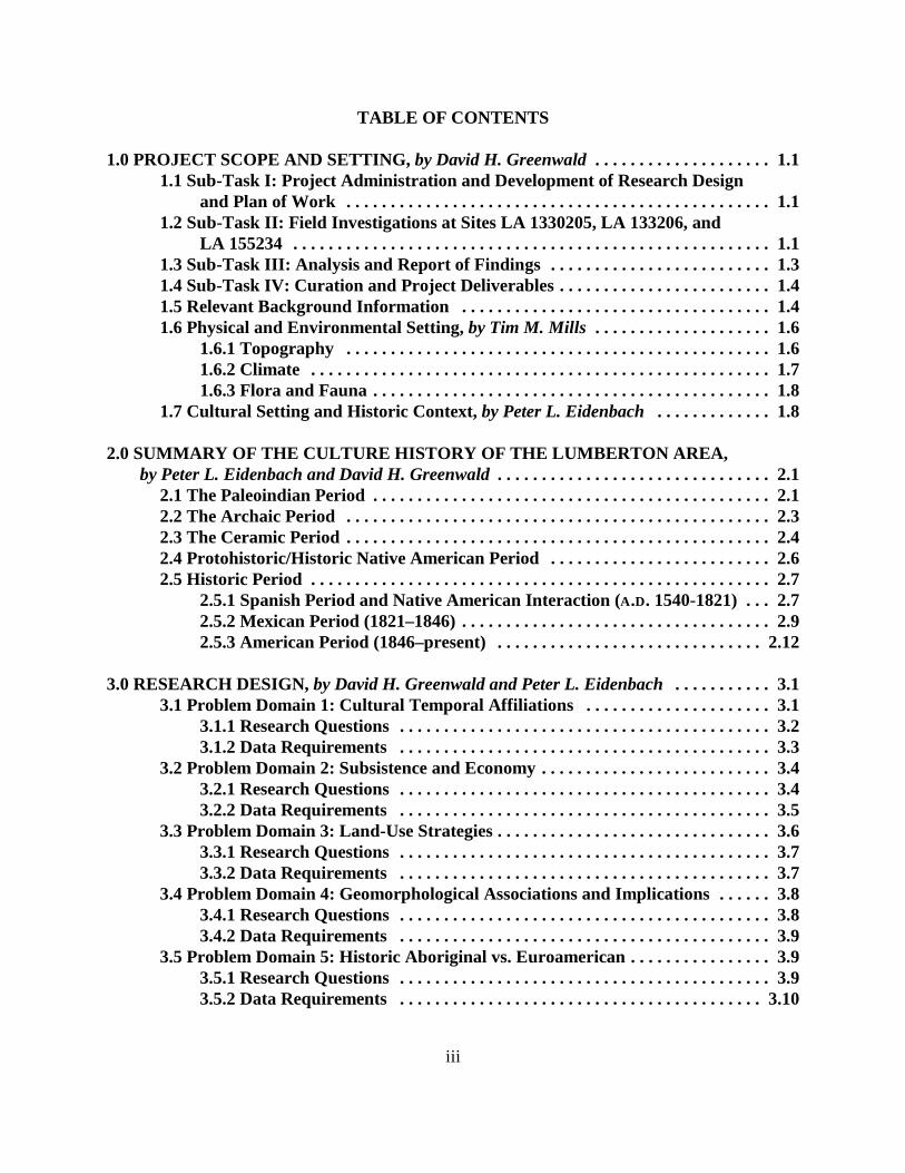
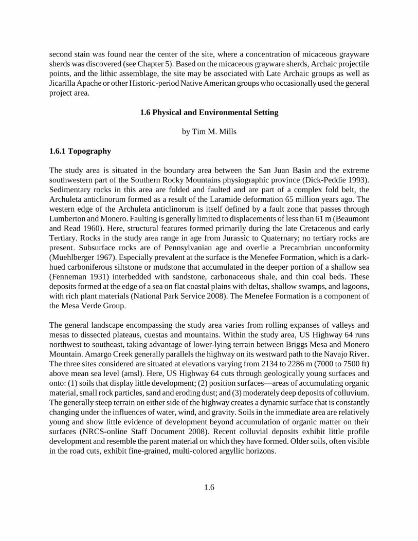
The New Mexico Department of Transportation (NMDOT) has proposed to improve a segment ofUS Highway 64 between Lumberton and US Highway 84, west of Chama, New Mexico (Figure 1.1).Cultural resources investigations were conducted at three sites along US Highway 64: at Milepost141.45 and Milepost 141.75 within the existing right-of-way, and at Milepost 145.0 within newlyacquired right-of-way. Cultural resource services included development of a research design and datarecovery plan (Greenwald 2008), data recovery investigations, analysis and data interpretations, andpreparation of a final report. Historic contexts of the resources have been defined and, to the extentpossible, compared with other pertinent and related investigations of similar temporal periods andtypes of sites in the area. Specific investigation methods used during field and analytical efforts arediscussed, including field methods, artifact analyses, and special samples (paleobotanical,radiocarbon, obsidian hydration and XRF studies, and archaeomagnetic analysis). This reportprovides interpretive summaries and management recommendations for the three project sites.
For management purposes, the project was divided into four sub-tasks, listed below. A briefdescription is presented for each sub-task.
1.1 Sub-Task I: Project Administration and Development ofResearch Design and Plan of Work
The first sub-task included project administration for the length of the project. Project administrationincluded project oversight and management by the David Greenwald, who served as the ProjectManager and Principal Investigator, and fiscal management by the Contract Administrator, DawnGreenwald. Time associated with this sub-task included setting up the Task Order within the FourCorners Research management system, including job costing, payroll records, and tracking project-specific expenses. As part of this sub-task, a Research Design and Plan of Work was prepared byDavid Greenwald, with contributions by Pete Eidenbach, Dawn Greenwald, and Tim Mills, to thestandards of NMDOT, reviewed by the Historic Preservation Division, and accepted by the CulturalProperties Review Committee (CPRC) prior to its implementation. The Research Design is includedas Chapter 3 of this report, with the Plan of Work as Chapter 4.
1.2 Sub-Task II: Field Investigations atSites LA 1330205, LA 133206, and LA 155234
Field Investigations were completed between May 12 and June 10, 2008. David Greenwald servedas the Field Supervisor, overseeing all aspects of the field investigations, reviewing and adjustingthe appropriateness of the field approach, and assigning tasks to other project members. Lindsay

ColoradoNew Mexico
Dulce
Continental Divide
LumbertonLA 133205 LA 133206
LA 155234Chama
Scale 1:500,000
0 10miles
NNNN
Map AreaNEW MEXICO
Heron Lake
El Vado
El VadoReservoir
Chama River
Willow Creek
17
117
Chama River
64
84
8464
84
96Rio Arriba County
Sandoval County
Jicarilla Apache IndianReservation
Figure 1.1. Project area location for data recovery at three sites along US Highway 64.
1.2
1.3
Poitevint served as Assistant Field Supervisor, providing direct supervision of the crew andimplementation of the Plan of Work. Three crew members, Heather Blanton, Tim Mills and JustinGreenwald, comprise the balance of the field personnel. GPS mapping and data collection wereconducted by Justin Greenwald. Phil Leckman, Statistical Research, mapped each site with a totalstation. During the course of the field efforts, Pete Eidenbach visited to examine the sites, assessprogress of project goals, and provide technical input. Steve Hall served as the projectGeomorphologist to address issues relating to formation processes, age of sediments and soildevelopment, and the association between natural formation processes and cultural deposition.Specific field and analytical methods used during this project are presented in Chapter 4 (Plan ofWork). In general, sites were surface collected and mapped. Control excavation units (1 × 1-m testpits) were dug at each site to examine the cultural and natural stratigraphy present and to quantifyartifact density per arbitrary or natural stratigraphic unit. Hand stripping was used to expose anddefine cultural features recognizable on the modern surface; features were divided into halves anddug by arbitrary or definable cultural levels. Mechanical stripping, using a backhoe with a smooth,1.5-m-wide bucket, was conducted at each site to search for additional subsurface features.Trenching was conducted at Site LA 155234 to provide additional exposure for geomorphologicalreview and assessment.
1.3 Sub-Task III: Analysis and Report of Findings
Following completion of the field efforts, all recovered artifacts that did not require special analysiswere cleaned and prepared for analysis under the direction of Dawn Greenwald, LaboratorySupervisor. Flaked stone, ground stone, and historic artifacts were submitted to the appropriateanalysts, with all lithic analyses conducted under the direction of Dawn Greenwald by HeatherBlanton and Justin Greenwald, and historic artifact analyses under the direction of Pete Eidenbachby Heather Blanton. Special samples were submitted to specialists (subconsultants) and laboratoriesfor analysis. Radiocarbon samples were submitted to Beta Analytic, archaeomagnetic samples to EricBlinman at the Laboratory of Anthropology, obsidian to Origer’s Obsidian Lab for hydration bandanalysis and to Geochemical Research Laboratory for trace mineral analysis, macrobotanical andpollen samples to Linda Scott Cummings and Kathryn Puseman at Paleo Research Laboratories, andfaunal remains to Kathy Duran at Eastern New Mexico University. Geomporhology studies wereconducted by Steve Hall, who also prepared a report based on his field observations. Report graphicswere generated by Jean Ann Mercer, Justin Greenwald, and Phil Leckman, and Gail Wimberlyserved as editor.
This descriptive and interpretive report integrates data recovered from the three project sites, whichhave been compared with other sites of similar temporal/functional associations in the region. Eachartifact and sample category was addressed within the construct of the research issues and questionsposed in the research design. All field, analytical, and reporting efforts have adhered to standards setforth in NMAC 4.10.16.12, NMAC 4.10.16.13 and NMAC 4.10.16.15. This report documents thefieldwork, background research, and each analysis conducted, and includes a discussion of projectbackground information, followed by a description of the natural and cultural setting, which helpdefine the historic context of the project area and introduce the research design developed for the
1.4
project. Project field and analytical methods are detailed, and project results include a presentationof site descriptions, feature narratives, and analytical interpretations. Data recovery results have beenintegrated and summarized, specifically addressing each aspect of the research design. Each site hasbeen placed within historic context, and management recommendations have been made. Supportivedocumentation has been included in appendices, as needed. Laboratory of Anthropology site formshave been updated, and the NIAF form included.
1.4 Sub-Task IV: Curation and Project Deliverables
The final sub-task involved preparation of all project-related materials (photographs, graphics,analytical data sheets, field records, etc.) for curation at the Museum of New Mexico and artifactsfor reburial at the project sites according to the terms of the project Memorandum of Agreement(MOA). This report has been prepared with the requisite number of copies produced and submittedto NMDOT (hard copies and electronic versions).
1.5 Relevant Background Information
A cultural resource survey of US Highway 64 from Milepost 140.0 to Milepost 148.7 was conductedin 2006 by Ecosystem Management, Inc. (EMI), under contract to Jones and Stokes Associates forthe NMDOT in partial support of proposed reconstruction of US 64 (Kuru’es et al. 2007). Thirteenpreviously discovered and five newly discovered sites were recorded as a result of that survey. Inconsultation with New Mexico Historic Preservation Division (NMHPD), NMDOT determined thatarchaeological data recovery was required at three sites (LA 133205, LA 133206, and LA 155234).Two of the sites, LA 133205 and LA 133206, were recorded in 2001 by Cibola Research Consultants(CRC) as part of a right-of-way fence replacement project (Marshall 2001). Both sites were foundto be in similar, intact condition when revisited by EMI in 2007. Buried fiber optic lines had beeninstalled within the southern portion of the US 64 right-of-way, extending through Sites LA 133205and LA 133206. One fiber optic line was buried in a backhoe trench and the other two were plowedor ripped in, creating much less subsurface disturbance. Installation caused considerable surfacedamage to the sites from heavy equipment and surface blading/backfilling. The third site, LA155234, was discovered as part of EMI’s survey (Kuru’es et al. 2007). Slope position and surfacedensity of its artifact scatter suggest that this site had been gradually eroding downslope, with surfaceartifact displacement affecting site integrity. Each site is briefly described below, based on previousdocumentation efforts (Kuru’es et al. 2007; Marshall 2001), followed by a presentation of theproposed project approach to fulfill the Section 106 process through mitigating potential adverseeffects to these previously determined National Register-eligible properties.
Site LA 133205 was previously described as a single component, chipped and ground stone artifactscatter assigned to the Middle Archaic. A thermal feature, a probable fire pit, represented by stainedsoil and fire-cracked rock (FCR), was described as exposed at the top of the road cut. The site ageand affiliation were originally assigned on the basis of the occurrence of a single San Rafael (orSudden Side-notched) projectile point (Marshall 2001:34). Land status of the site within the right-of-way is NMDOT land (acquired from private sources) and beyond the right-of-way is private. An area
1.5
approximately 10 m wide by 25 m long was identified within the right-of-way as requiring data-recovery investigations. Data-recovery investigations indicated that the origins of the stains andburned vegetation may have originated from both cultural and natural events (see Chapter 5).
Site LA 133206 was previously described as a multicomponent artifact scatter of unknownprehistoric, historic and recent age; during its initial (Marshall 2001) and subsequent (Kuru’es et al.2007) recordings, it was described as consisting of two thermal features and an artifact scatter(within the US 64 right-of-way), and a modern corral and a concentration of sandstone rubble (bothlocated beyond the US 64 right-of-way). The corral is located north of the existing right-of-way andappears to date after 1950, based on oak rails with bark attached and military surplus metal used aspanels. The modern corral is still in use. The sandstone was described as scattered over an areaapproximately 4 m in diameter, located south of the existing right-of-way, and associated with amberglass and turn-of-the-century steel cans. After gaining permission from the landowner, the rubblearea was examined and found to extend over a larger area than previously reported (approximately10 × 10 m), possibly representing a sandstone foundation(s) that has been scattered by laterdisturbance. The two thermal features were associated with a lithic scatter (both flaked and groundstone). The historic artifact scatter was present on both sides of US 64 in the right-of-way. Asidefrom the historic artifacts, the site’s temporal/cultural association prior to data-recovery efforts waslisted as unknown. The site includes multiple components that represent probable Archaic- andHistoric-period use of the area, with the historic materials associated with either an Anglo, Hispanic,or Native American presence (or combined ethnic association); historic accounts indicate the generalarea had been used by Jicarilla Apache, Navajo, and Utes from at least 1850 through the earlyestablishment of the Jicarilla Apache Indian Reservation into the early twentieth century (Levine etal. 1996:31-37). Both thermal features, as initially described by Marshall (2001), were positionedat the margin of the existing south road cut, having been exposed in the top of the slope cut. Data-recovery efforts were proposed within an area 20.0 m wide by 37.5 m long in the north right-of-way,and 20.0 m wide by 56.0 m long in the south right-of-way. Excavations and mechanical strippingwere extended to the west along the south right-of-way when surface-collecting efforts indicated thesurface scatter extended an additional 10 to 15 m beyond the originally defined boundary (seeChapter 5).
During the original recording, Site LA 155234 was described as a prehistoric artifact scatter with alarge area of charcoal-stained soil, probably the remnant of a single thermal feature (Kuru’es et al.2007:31), suggested to be an Archaic-period campsite/processing area. The Late Archaic affiliationwas based on the variety of lithic material types and a high frequency of bifacial thinning flakes.Lithic materials included two distinct types of obsidian. Also present were two manos and a slabmetate. The location of Site LA 155234 falls within the newly acquired right-of-way for therealignment of US 64 at Deadman’s Curve, where construction will completely alter the landscapeand remove the site. Prior to initiating data-recovery efforts, portions of the site’s surface wereeroded, with exposed rock and shallow colluvial materials. Due to the slope and eroded appearanceof the site area, Kuru’es et al. (2007) suggested that artifacts were being translocated downslope byerosion. Because the site is within newly acquired right-of-way, the entire site was investigated,amounting to a maximum area of 65 m wide by 75 m long. During surface collection efforts, a
1.6
second stain was found near the center of the site, where a concentration of micaceous graywaresherds was discovered (see Chapter 5). Based on the micaceous grayware sherds, Archaic projectilepoints, and the lithic assemblage, the site may be associated with Late Archaic groups as well asJicarilla Apache or other Historic-period Native American groups who occasionally used the generalproject area.
1.6 Physical and Environmental Setting
by Tim M. Mills
1.6.1 Topography
The study area is situated in the boundary area between the San Juan Basin and the extremesouthwestern part of the Southern Rocky Mountains physiographic province (Dick-Peddie 1993).Sedimentary rocks in this area are folded and faulted and are part of a complex fold belt, theArchuleta anticlinorum formed as a result of the Laramide deformation 65 million years ago. Thewestern edge of the Archuleta anticlinorum is itself defined by a fault zone that passes throughLumberton and Monero. Faulting is generally limited to displacements of less than 61 m (Beaumontand Read 1960). Here, structural features formed primarily during the late Cretaceous and earlyTertiary. Rocks in the study area range in age from Jurassic to Quaternary; no tertiary rocks arepresent. Subsurface rocks are of Pennsylvanian age and overlie a Precambrian unconformity(Muehlberger 1967). Especially prevalent at the surface is the Menefee Formation, which is a dark-hued carboniferous siltstone or mudstone that accumulated in the deeper portion of a shallow sea(Fenneman 1931) interbedded with sandstone, carbonaceous shale, and thin coal beds. Thesedeposits formed at the edge of a sea on flat coastal plains with deltas, shallow swamps, and lagoons,with rich plant materials (National Park Service 2008). The Menefee Formation is a component ofthe Mesa Verde Group. The general landscape encompassing the study area varies from rolling expanses of valleys andmesas to dissected plateaus, cuestas and mountains. Within the study area, US Highway 64 runsnorthwest to southeast, taking advantage of lower-lying terrain between Briggs Mesa and MoneroMountain. Amargo Creek generally parallels the highway on its westward path to the Navajo River.The three sites considered are situated at elevations varying from 2134 to 2286 m (7000 to 7500 ft)above mean sea level (amsl). Here, US Highway 64 cuts through geologically young surfaces andonto: (1) soils that display little development; (2) position surfaces—areas of accumulating organicmaterial, small rock particles, sand and eroding dust; and (3) moderately deep deposits of colluvium.The generally steep terrain on either side of the highway creates a dynamic surface that is constantlychanging under the influences of water, wind, and gravity. Soils in the immediate area are relativelyyoung and show little evidence of development beyond accumulation of organic matter on theirsurfaces (NRCS-online Staff Document 2008). Recent colluvial deposits exhibit little profiledevelopment and resemble the parent material on which they have formed. Older soils, often visiblein the road cuts, exhibit fine-grained, multi-colored argyllic horizons.
1.7
1.6.2 Climate
The seasonal weather pattern is a reflection of the area’s elevation and intercontinental positioning.The average daily maximum and minimum temperatures at Dulce are 62 and 26 degrees F,respectively (Overdier 2004) . Nevertheless, extremes of 97 and -47 degrees F have been recorded.In five years out of ten, October 2 is the first freeze date, with May 22 the last. Thus, in an averageyear, the number of frost-free days is insufficient for modern varieties of corn to reach maturity (evendiscounting a requirement for a minimum soil temperatures of 50 degrees F for kernel germination).In nine out of ten years, only 107 days occur where the daily minimum temperature (DMT) risesabove 24 degrees F, 84 days where the DMT rises above 28 degrees F, and only 49 days where theDMT rises above 32 degrees F (Overdier 2004). This extremely short growing season, along withthe accompanying reality of low annual mean temperature, precludes the cultivation of almost everyvariety of staple crop and must be considered a significant factor in dictating the prehistoric andhistoric economies that could be practiced within the Dulce/Monero area.
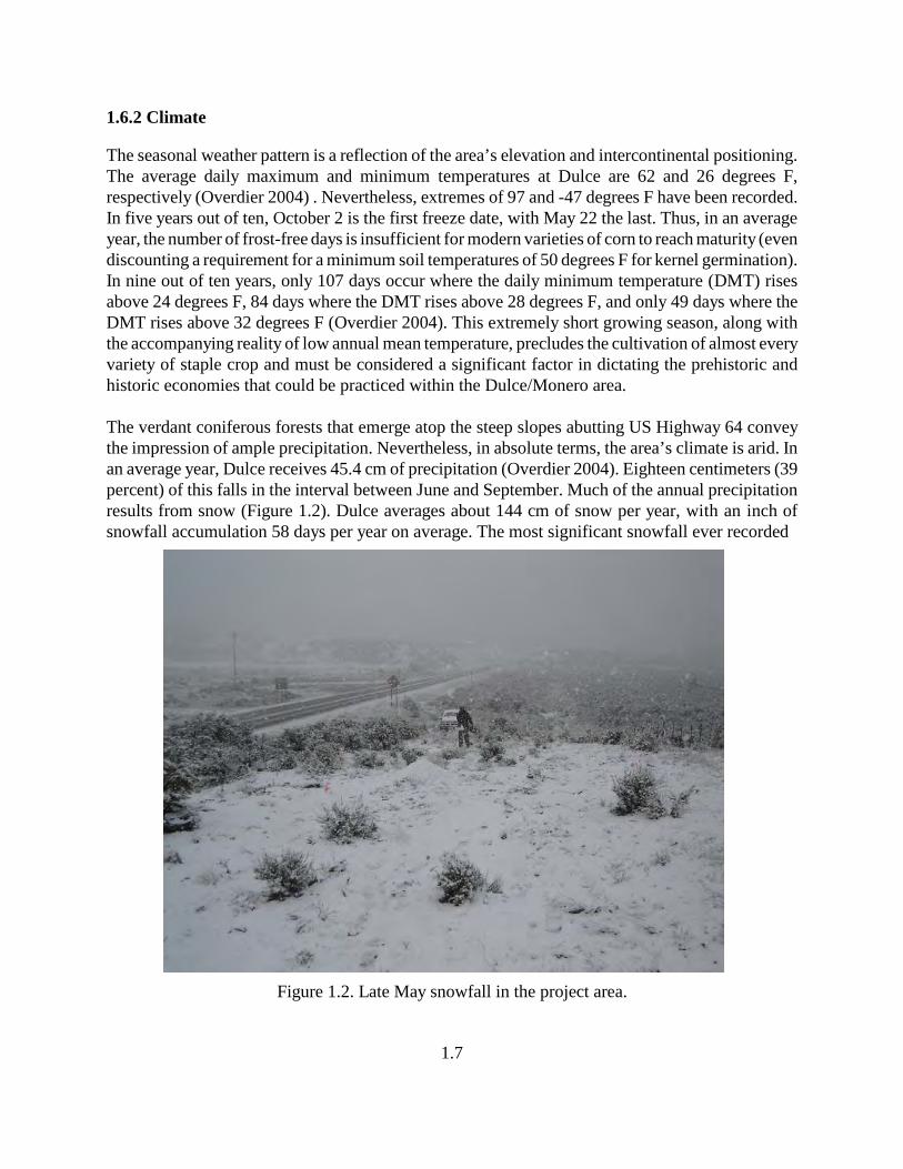
The verdant coniferous forests that emerge atop the steep slopes abutting US Highway 64 conveythe impression of ample precipitation. Nevertheless, in absolute terms, the area’s climate is arid. Inan average year, Dulce receives 45.4 cm of precipitation (Overdier 2004). Eighteen centimeters (39percent) of this falls in the interval between June and September. Much of the annual precipitationresults from snow (Figure 1.2). Dulce averages about 144 cm of snow per year, with an inch ofsnowfall accumulation 58 days per year on average. The most significant snowfall ever recorded
Figure 1.2. Late May snowfall in the project area.
1.8
during any one interval has been 102 cm. The average relative humidity is about 28 percent duringmid-afternoon. At dawn the humidity rises to an average of 60 percent. Thunderstorms occur onabout 41 days each year, and predominantly in July and August in harmony with the monsoon patternprevalent in the southwestern United States.
1.6.3 Flora and Fauna
The steep rising terrain elicits rapid changes in vegetational communities. Three separate types canbe distinguished in areas immediately adjacent to the highway (Dick-Peddie 1993). The highestelevations are dominated by the Ponderosa Pine-Gambel Oak Series of the Lower MontaneConiferous Forest group. Below that, vegetation changes to a mixed coniferous woodland whereGamble Oak predominates, probably due to episodes of disturbance and fire. Still lower, on thecolluvium, mixed woodlands give way to a mixed savanna of juniper and sage. Species observedwithin the immediate area of the three sites include: Gambel oak (Quercus gambelii), ponderosa pine(Pinus ponderosa), Utah juniper (Juniperus osteosperma), piñon pine (Pinus edulis), chokecherry(Prunus virginiana), fourwing saltbush (Atriplex canescens), threeleaf sumac (Rhus trilobata), sandsagebrush (Artemesia filifolia), big sagebrush (Artemisia tridentata), paintbrush (Castillega integra),yarrow (Achillea lanulosa), Oregon grape (Berberis repens), lupine (Lupinus sp.), evening primrose(Oenothera spp.), larkspur ( Delphium bicolor), death camas (Zygadenus venenosus), and grounddaisy (Erigeron sp.).
The present environment provides habitat for a variety of wildlife taxa, including mule deer(Odocoileus hemionus), fox (Canidae), coyote (Canis latrans), cottontail rabbits (Sylvilagus sp.) andjackrabbits (Lepus sp.), various burrowing rodents, squirrels (Sciurus sp.), quail (Columbidae),hawks (Accipiter sp./Buteo sp.), jays (Corridae), ravens (Corvus corax), and other bird species.Rabbits appear to be the most common. Although it is not clear which of these species occupied theproject area prehistorically, many of these species were likely important to the subsistence strategyof prehistoric and historic groups given that agriculture was not possible.
1.7 Cultural Setting and Historic Context
by Peter L. Eidenbach
The project area occupies a relatively unsurveyed lacuna immediately east of the Jicarilla ApacheIndian Reservation and the San Juan Basin, north and west of the Upper Rio Grande and Gallinacultural areas (Poague et al. 1996; Stuart and Gauthier 1984). To demonstrate the limited level ofprevious studies, recorded site densities within the Jicarilla Apache Indian Reservation to the west,for example, are approximately 25 sites per square mile, whereas only 25 sites are distributed withina 64 square mile area around the US Highway 64 study area, with most of these found alongtransportation corridors or in and around historic villages. These estimates suggest that surveyintensity has been about 64 times greater on the Reservation as compared to the US 64 study area.Are actual site densities that much greater to the west? The study area, which is located immediatelywest of the Continental Divide, is slightly higher in elevation than the nearby Jicarilla Apache Indian
1.9
Reservation, but not significantly so. The elevational difference may reduce the number of frost-freedays to a level even lower than reported for Dulce, as reported above by Mills, and may have affectedhistoric and prehistoric use of the general project area to a greater extent than found at Dulce. Onlyadditional areal survey in the vicinity will clarify differing site densities and conclusively define atemporal sequence of prehistoric land use.
In 1981, Stuart and Gauthier noted the lack of survey in north-central and northeastern New Mexico.They also commented on the common attribution of small surface lithic sites to Archaic-periodgroups based solely on occasional projectile point styles. They pointed out that some of these pointstyles in the northern part of the state had great longevity–up to 5000 years. In addition, manyinvestigators throughout the state have noted that useable stone tools were often collected and reusedby later peoples. Projectile points, in particular, were often included in Navajo medicine bundles.A noteworthy example of such reuse is a side-notched Folsom point recovered from Rhodes Canyonin south-central New Mexico (Eidenbach 1983). Because, as Kuru’es et al. (2007) note, quality lithicsource material is scarce in the area, collection and reuse of selected material and finished, useabletools is even more likely. The lack of quality source material also has importance in determiningcultural affiliation. Distinctive materials can often be traced to a geographic source, as alreadysuggested by Kuru’es et al.’s (2007) identification of both Jemez and Polvadera obsidian(specifically identified as Cerro del Medio and Polvadera obsidian by Hughes, this volume).Additionally, consideration must be given to the variety and composition of lithic materialsrecovered from the project sites and the implications of the material types represented and theirrelative frequencies within the assemblages and between sites. In doing so, the obsidian and thevariety of other exotic lithic material seems to have distinguished Site LA 155234 from Sites LA133205 and LA 133206.
Soils in the vicinity of Sites LA 133205 and LA 133206 include Hogg-Mara loams and Suposo-Brycan complex derived from colluvium and stream alluvium (Natural Resource ConservationService Staff Document 2008). In this upland environment, with annual precipitation in excess of41 cm, these surface soils are likely to be fairly recent, suggesting that the lithic components are notlikely to be significantly older than the closely associated historic materials found on Site LA133206. The presence of a weak A horizon formed from weathered shale and positioned abovecolluvial deposits tend to support this inference regarding the age of surface soils (see Chapter 9 forStephen Hall’s geomorphology study of the three project sites). Importantly, rather than Archaic,these scatters may have originated from protohistoric or historic Native American activities. In fact,it is possible that the historic glass and cans may also be associated with Native American activity.Similar associations are known from the traditional range of the Mescalero Apache to the southwhere they are associated with railroad corridors (Eidenbach 1990; Gossett and Eidenbach 1980).These associations are considered within the analyses and data interpretations of the artifactassemblages of this project in an attempt to address temporal/cultural affiliations.
2.1
2.0 SUMMARY OF THE CULTURE HISTORY OF THE LUMBERTON AREA
by Peter L. Eidenbach and David H. Greenwald
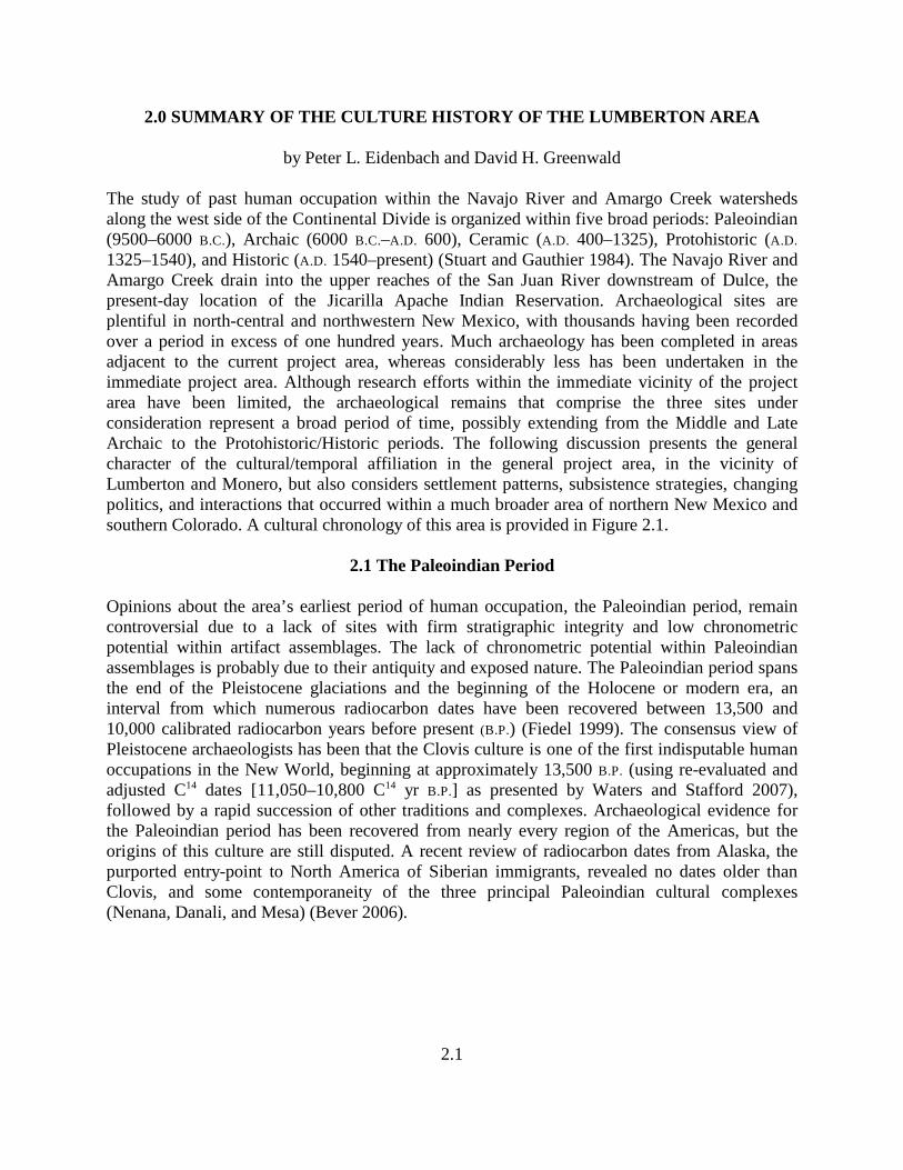
The study of past human occupation within the Navajo River and Amargo Creek watershedsalong the west side of the Continental Divide is organized within five broad periods: Paleoindian(9500–6000 B.C.), Archaic (6000 B.C.–A.D. 600), Ceramic (A.D. 400–1325), Protohistoric (A.D.
1325–1540), and Historic (A.D. 1540–present) (Stuart and Gauthier 1984). The Navajo River andAmargo Creek drain into the upper reaches of the San Juan River downstream of Dulce, thepresent-day location of the Jicarilla Apache Indian Reservation. Archaeological sites areplentiful in north-central and northwestern New Mexico, with thousands having been recordedover a period in excess of one hundred years. Much archaeology has been completed in areasadjacent to the current project area, whereas considerably less has been undertaken in theimmediate project area. Although research efforts within the immediate vicinity of the projectarea have been limited, the archaeological remains that comprise the three sites underconsideration represent a broad period of time, possibly extending from the Middle and LateArchaic to the Protohistoric/Historic periods. The following discussion presents the generalcharacter of the cultural/temporal affiliation in the general project area, in the vicinity ofLumberton and Monero, but also considers settlement patterns, subsistence strategies, changingpolitics, and interactions that occurred within a much broader area of northern New Mexico andsouthern Colorado. A cultural chronology of this area is provided in Figure 2.1.
2.1 The Paleoindian Period
Opinions about the area’s earliest period of human occupation, the Paleoindian period, remaincontroversial due to a lack of sites with firm stratigraphic integrity and low chronometricpotential within artifact assemblages. The lack of chronometric potential within Paleoindianassemblages is probably due to their antiquity and exposed nature. The Paleoindian period spansthe end of the Pleistocene glaciations and the beginning of the Holocene or modern era, aninterval from which numerous radiocarbon dates have been recovered between 13,500 and10,000 calibrated radiocarbon years before present (B.P.) (Fiedel 1999). The consensus view ofPleistocene archaeologists has been that the Clovis culture is one of the first indisputable humanoccupations in the New World, beginning at approximately 13,500 B.P. (using re-evaluated andadjusted C dates [11,050–10,800 C yr B.P.] as presented by Waters and Stafford 2007),14 14
followed by a rapid succession of other traditions and complexes. Archaeological evidence forthe Paleoindian period has been recovered from nearly every region of the Americas, but theorigins of this culture are still disputed. A recent review of radiocarbon dates from Alaska, thepurported entry-point to North America of Siberian immigrants, revealed no dates older thanClovis, and some contemporaneity of the three principal Paleoindian cultural complexes(Nenana, Danali, and Mesa) (Bever 2006).
CULTURE
(NMCRIS
1993)
PERIOD DATES
Paleoindian Pre-Clovis <9500 BC
Clovis 9500-9000 BC
Folsom/Midland 9000-8000 BC
LatePaleoindian
8000-6600 BC
TerminalPaleoindian
6600-5500 BC
Archaic Early Archaic 5500-3000 BC
Middle Archaic 3000-1800 BC
Late Archaic 1800BC-AD200
PecosClassification
Basketmaker II 200 BC-AD 400
Basketmaker III AD 400-700
Pueblo I AD 700-900
Pueblo II AD 900-1100
Pueblo III AD 1100-1300
Pueblo IV AD 1300-1600
Hispanic,Anglo/Euro-American,Pueblo, Ute,and Apache
SpanishContact/Colonial
AD 1539-1680
Pueblo Revolt AD 1680-1692
Post PuebloRevolt
AD 1692-1821
Mexican AD 1821-1846
US Territorial AD 1846-1912
REGIONAL
(Traditions/
Areas)
PHASE/
COMPLEX
DATES
Paleoindian Pre-Clovis <9500 BC
Clovis 9500-9000 BC
Folsom 9000-8000 BC
LatePaleoindian
8000-5500 BC
OsharaTradition(Irwin-Williams1973)
Jay 5000-4800 BC
Bajada 4800-3200 BC
San Jose 3200-1800 BC
Armijo 1800-800 BC
En Medio 800 BC-AD400
Trujillo AD 400-600
Sky Village AD 600-700
Loma Alta AD 700-850
Gallina Area(Dick 1976)
Hiatus AD 950-1050
Gallina AD 1050-1300
Abandonment AD 1300-1600
Hispanic,Anglo/Euro-American,Pueblo, Ute,and Apache
SpanishContact/Colonial
AD 1539-1680
Pueblo Revolt AD 1680-1692
Post PuebloRevolt
AD 1692-1821
Mexican AD 1821-1846
US Territorial AD 1846-1912
Figure 2.1. Cultural chronology of northern New Mexico.
2.3
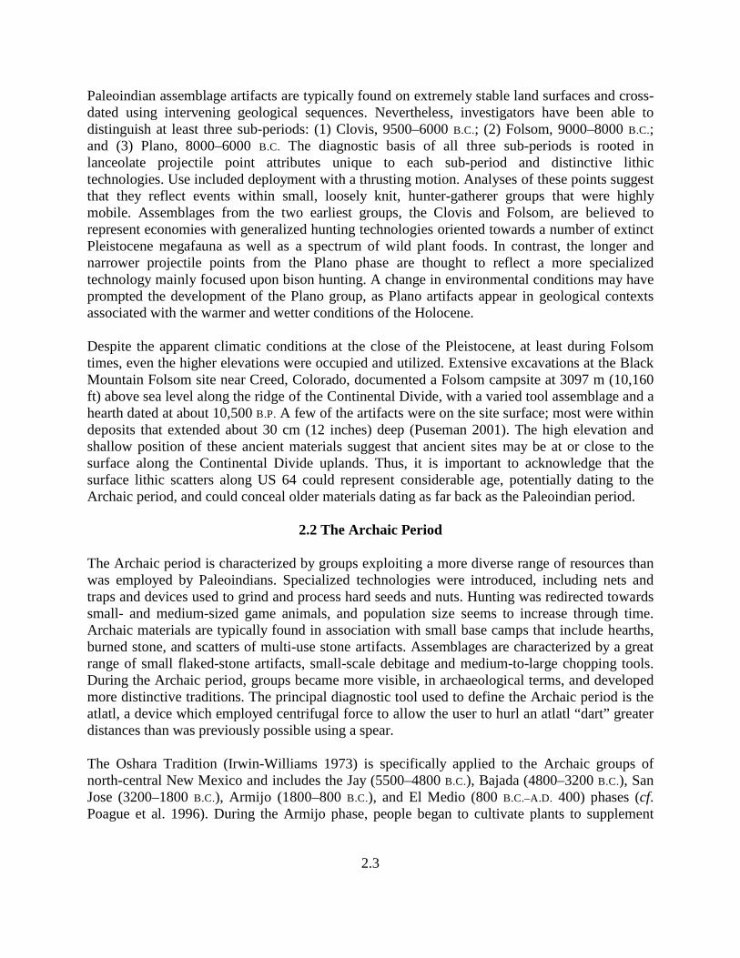
Paleoindian assemblage artifacts are typically found on extremely stable land surfaces and cross-dated using intervening geological sequences. Nevertheless, investigators have been able todistinguish at least three sub-periods: (1) Clovis, 9500–6000 B.C.; (2) Folsom, 9000–8000 B.C.;and (3) Plano, 8000–6000 B.C. The diagnostic basis of all three sub-periods is rooted inlanceolate projectile point attributes unique to each sub-period and distinctive lithictechnologies. Use included deployment with a thrusting motion. Analyses of these points suggestthat they reflect events within small, loosely knit, hunter-gatherer groups that were highlymobile. Assemblages from the two earliest groups, the Clovis and Folsom, are believed torepresent economies with generalized hunting technologies oriented towards a number of extinctPleistocene megafauna as well as a spectrum of wild plant foods. In contrast, the longer andnarrower projectile points from the Plano phase are thought to reflect a more specializedtechnology mainly focused upon bison hunting. A change in environmental conditions may haveprompted the development of the Plano group, as Plano artifacts appear in geological contextsassociated with the warmer and wetter conditions of the Holocene.
Despite the apparent climatic conditions at the close of the Pleistocene, at least during Folsomtimes, even the higher elevations were occupied and utilized. Extensive excavations at the BlackMountain Folsom site near Creed, Colorado, documented a Folsom campsite at 3097 m (10,160ft) above sea level along the ridge of the Continental Divide, with a varied tool assemblage and ahearth dated at about 10,500 B.P. A few of the artifacts were on the site surface; most were withindeposits that extended about 30 cm (12 inches) deep (Puseman 2001). The high elevation andshallow position of these ancient materials suggest that ancient sites may be at or close to thesurface along the Continental Divide uplands. Thus, it is important to acknowledge that thesurface lithic scatters along US 64 could represent considerable age, potentially dating to theArchaic period, and could conceal older materials dating as far back as the Paleoindian period.
2.2 The Archaic Period
The Archaic period is characterized by groups exploiting a more diverse range of resources thanwas employed by Paleoindians. Specialized technologies were introduced, including nets andtraps and devices used to grind and process hard seeds and nuts. Hunting was redirected towardssmall- and medium-sized game animals, and population size seems to increase through time.Archaic materials are typically found in association with small base camps that include hearths,burned stone, and scatters of multi-use stone artifacts. Assemblages are characterized by a greatrange of small flaked-stone artifacts, small-scale debitage and medium-to-large chopping tools.During the Archaic period, groups became more visible, in archaeological terms, and developedmore distinctive traditions. The principal diagnostic tool used to define the Archaic period is theatlatl, a device which employed centrifugal force to allow the user to hurl an atlatl “dart” greaterdistances than was previously possible using a spear.
The Oshara Tradition (Irwin-Williams 1973) is specifically applied to the Archaic groups ofnorth-central New Mexico and includes the Jay (5500–4800 B.C.), Bajada (4800–3200 B.C.), SanJose (3200–1800 B.C.), Armijo (1800–800 B.C.), and El Medio (800 B.C.–A.D. 400) phases (cf.Poague et al. 1996). During the Armijo phase, people began to cultivate plants to supplement
2.4
their diet and to increase the predictability of their food supply. In some parts of the Southwest,sedentary villages appeared.
2.3 The Ceramic Period
The introduction of ceramics signals the beginning of sedentism, initially represented by theBasketmaker II and III periods. The Basketmaker II (200 B.C.–A.D. 400) economy utilized wildplant foods and small game, with a secondary subsistence strategy centered about domesticatedcrops. Village life was focused upon closely organized groupings of small pit houses or jacalasor transitional rectilinear-shaped domiciles paving the way for what would later evolve intocontiguous above-ground rooms, forming pueblos. Basketmaker II sites could be situated ongraded or terraced landforms or in rockshelters, and individual dwellings typically included areasspecifically dedicated to food storage. Unfired ceramics and a wide range of basketry arecommon artifacts of Basketmaker II assemblages. A variety of burial practices were used, withinhumation burials placed into shallow-pit graves being the most common.
During the Basketmaker III period (A.D. 400–700), the bow and arrow supplanted the atlatl anddart, and the production of grayware ceramics commenced, including decorated pottery usingblack paint and simple designs. Houses were semi-subterranean, with approximately half builtbelow ground level and incorporating a timber roof supported by a framework commonly using afour-post pattern. The roof was covered by soil to aid drainage. The main chamber of the houseincluded a bench, which also anchored the upper sides of the roof, and an antichamber, whichserved as the entrance, a storage area, and part of the ventilation system. Their constructionassumed a stylized vernacular layout, with a ventilator opening/passage way, fire pit, deflectorblock and sipapu (a small opening or indentation in the floor). Additional storage featuresincluded small, rectangular surface structures. Each was constructed as a free-standing structureand often included pits beneath the floor for additional storage.
The Pueblo period is initially represented by construction of deeper pit houses and contiguoussurface rooms. Surface rooms were largely used for storage, but as their size was enlarged, otheractivities were conducted within them, with some being used as part-time habitations. Theassociation between pit house and surface rooms is often considered the related space of anindividual family or unit pueblo. Black-on-gray ceramics give way to black-on-white types, withcorrugated graywares introduced as utilitarian ware. The Pueblo II period was signaled by thedevelopment of multi-family and multi-level architectural works. Habitations moved from the pithouse to above-ground dwellings, and pit houses were replaced by kivas, non-habitationceremonial structures. It is generally accepted (Scarborough 1989:405) that these changesreflect: 1) greater differentiation with respect to activity; 2) less household mobility and greatersettlement longevity; 3) a greater dependence on agriculture; 4) a reliance on food storage; and5) an increased level of population growth. All these factors probably combined to create aprerequisite for greater inter-group cooperation.
In the general project area, the Rosa phase (A.D. 700–750) shows signs of continuity with earlierand contemporaneous Basketmaker III groups. A paucity of faunal remains has led investigatorsto conclude that Rosa phase peoples were either agriculturalists or specialized hunters who
2.5
butchered and preserved meats at remote locations. During this phase, pit houses were used.These were generally circular, 2+ m (6+ ft) deep and 6-12 m (20-39 ft) in diameter, sometimesarranged in groups surrounded by a stockade-like feature. Their layout included a bench cutthree-fourths of the way around the interior pit house wall with a small rounded storage bin ateither end. Cooking and heating was accomplished by a fire pit cut into the floor, with aventilator shaft penetrating through the bench and extending to the surface. Storage units werearranged in a crescent shape against the back wall, sometimes in double rows. Basketry was animportant craft and served as a model for the ceramics that followed. Ceramic vessels weretypically crude, undecorated forms known as Rosa (1) Smoothed; (2) Utility; and (3) Black-on-white. Rosa Smoothed includes two subtypes (brown and gray), both composed of sandy, softclay with opaque, glittering or white rounded inclusions. Rosa Utility employs a heavy randomfinish, sometimes with vertical scoring. The final form, Rosa Black-on-white, utilizes basketryprints in areas surrounding the base, rolled rims and simplified Pueblo I motifs executed with acarbon-based paint. Surfaces tend to be floated rather than slipped and bowls predominate overjars by a wide margin. The Rosa phase terminates with the development of the Piedra phase (A.D.
750–950) and the Aboles or Bancos phase (A.D. 950–1050), both obscured by a lack of securesites. According to Stuart and Gauthier (1984), the area underwent an occupational hiatus fromA.D. 950 to A.D. 1100.
The Gallina phase (A.D. 1050–1300) has been characterized as isolated with respect to adjacentMesa Verde and Chaco groups (Ellis 1988). Differences in household architecture, settlementpatterns, and ceramic designs have combined to lead investigators to conclude that the Gallinaphase is distinctly different with respect to Pueblo II and III Anasazi (Dick 1980). Gallinavillages had a dispersed settlement pattern with fields and homes scattered over considerabledistance. Habitation sites supported only a few families at the most, and house design wasrestricted to either pit house or unit pueblos. Unit pueblos were little more than pit houses builtat ground level, with their floor plans nearly identical to that of their Basketmaker III ancestors.Both house forms were built of unworked stone set into mortar with the inside plastered withclay. Common features associated with habitation sites are stockades, or areas enclosed bywooden stakes. Burials that exhibit violent death and defensive enclosures such as the stockadeimply that warfare was common in the area during this time. Gallina ceramic types included agrey utility ware and a simple black-on-white. There is little evidence for centralized religiousactivities such as that represented by kivas elsewhere. In addition to village sites, the Gallinaconstructed remote camp houses presumably for the purpose of gathering and processing wildfoodstuffs. Gallina field systems included ramadas associated with cobble-bordered plots thatwere occasionally equipped with dams and terraces required for the cultivation of crops undermarginal conditions (Anschuetz 1992). Mackey and Holbrook (1978) concluded that climaticdeterioration during a period from A.D. 1100 to A.D. 1200 was a key factor in the abandonment ofGallina sites.
2.6
2.4 Protohistoric/Historic Native American Period
From approximately A.D. 1325 until the establishment of permanent European settlements (A.D.
1598), the Protohistoric was a period of tremendous cultural change in the Southwest, marked bypopulation movement and aggregation of existing ceramic-producing agriculturalists, and theimmigration of groups from California, the Central Plains, and the Yukon region that werehighly mobile and practiced variations on hunting/gathering lifeways. Population aggregationinto sites in excess of 100 rooms (some with over 2500 rooms) and the development ofglazeware and biscuit pottery are the hallmarks of this phase, which witnessed the end of theblack-on-white tradition of ceramic decoration with Wiyo Black-on-white. Much smallerhabitation sites, with an average of four rooms, are also common during this period, perhapsassociated with agricultural intensification. With population centers of such enormity, as well asthe common small (four-room) habitation sites, broad-based subsistence practices may havebeen needed in addition to intensive agricultural practices along major drainage systems tosupport a regionally aggregating population. In the Gallina area, small habitation sites werecommon during the preceding period, perhaps associated with the marginal character of theContinental Divide area for agriculture. Higher elevations have shorter growing seasons, oftenrequiring subsistence-based groups to incorporate a variety of economic methods into theirsurvival strategies, which may cause them to be mobile and dependent upon the availability ofnatural resources, both floral and faunal. In this regard, the Chama/Lumberton area may havebeen extensively exploited for its natural resources from the Paleoindian and Archaic periodsthrough the Protohistoric and Historic periods with few long-term, well-established settlements.Late Puebloan-style projectile points support such a strategy, with limited use of potteryrepresented. The focus of economic pursuits continued to be on hunting and gathering and,probably, use of more portable containers such as basketry.
The Protohistoric period in the Southwest witnessed considerable repositioning of groups, bothestablished groups from the preceding Coalition phase and newcomers, such as the Utes,Apaches, and Navajos (Wilcox 1981). Pressure from Plains groups (Comanche and Kiowa)pushed some resident groups farther into the recesses of the Basin and Range setting andsouthern Rocky Mountains. Utes, Apaches, and Navajos responded to this repositioning ofsedentary groups as they aggregated into larger communities. The Continental Divide area ofsouthern Colorado and northern New Mexico was eventually occupied by these later arrivals,who sought resources from this upland area, some of whom adopted maize agriculture.Presumably, these attempts were undertaken to supplement foraging subsistence practices.
Utes ranged over much of the area north of the present project area through southwestern andsouthern Colorado and extreme northern New Mexico. The Navajo utilized the canyon countryof the San Juan River and its tributaries west of the project area. The Jicarilla Apache eventuallymigrated into the general project area as they were pressured from one direction or another.After initially arriving in the Southwest, the Jicarilla Apache located on the eastern slopes of theSangre de Cristo Mountains east of Taos (Gunnerson 2006:5) in the Cimarron District, wherethey practiced a semi-sedentary subsistence strategy adopted through contact with variouspueblo groups of the area. They ranged over a vast area of northeastern New Mexico andsouthern Colorado, extending as far west as the Rio Chama (Opler 1936:202). Continued
2.7
pressure by the Comanche and later by Euroamerican populations displaced them further west,into the Rio Chama drainage and into the area of Tierra Amarilla. Here, during the earlyTerritorial period, government attempts were undertaken to confine the movement of thesemobile people.
A reservation was proposed in the Tierra Amarilla area, but was voted down due to objectionsfrom residents of the Chama Valley. Unrest led to the Jicarilla fleeing into the mountains ofnorthern New Mexico and southern Colorado, and the proposal to establish a Jicarilla reservationwest of the Rio Grande was abandoned. In 1866, the Jicarilla again attempted to settle in theTierra Amarilla area, requesting a reservation be established. Camp Plummer was established tocontrol related problems, but the reservation request was never implemented. In 1874, an attemptwas made to establish a reservation on the headwaters of the San Juan, an area that essentiallyincluded the project area, but was overwhelmingly rejected by local Anglo settlers. Many of theJicarillas were concentrated in the Tierra Amarilla area during this time, and without adesignated home, the Jicarillas were sent to Mescalero in 1883 (Tiller 1983:89-91), but slowlyreturned to the headwaters of the San Juan. In 1887, the government established the firstreservation (Tiller 1983:94-97), which now is included within the current reservation boundary.
2.5 Historic Period
The Euroamerican historic record of the region is divided into three periods based on whichnation exerted sovereignty: 1) Spanish, 2) Mexican, and 3) American. During this time, Nativepeoples in New Mexico devised various responses to the European and Euroamerican incursions.Historically, this general area is poorly documented until the mid-nineteenth century. More thana century would pass after Coronado's journey northeast in search of Quivira before NewMexico's Spaniards would explore northward.
2.5.1 Spanish Period and Native American Interaction (1540–1821)
The Coronado Expedition of 1540 marked the first of a series of European incursions into theRio Grande valley (Athearn 1989), culminating in 1598 with Juan de Oñate’s development of aNew Mexico colony at San Juan de Caballeros (Vaughn 1923:44-54). This site, the Pueblovillage of Yunge Oweenge, was located about 30 miles north of Santa Fe and was intended asOñate’s capital settlement. In 1601, the capital was moved across the Rio Grande to a new site atSan Gabriel. In 1608, Oñate resigned as Governor of the colony. Villa Nueva de Santa Fe wassubsequently founded in 1609 (Athearn 1989:3; Vaughn 1923:55-66). During the period1609–1680, the Spaniards developed New Mexico through a system of religious missions,military presidios, and agricultural land grants or encomiendas (Athearn 1989:3). This effortincluded enslavement of Native Americans and debt peonage (Vaughn 1923:169), practices thatwere met with resistance by the Native peoples of New Mexico, culminating in the PuebloRevolt of 1680; only two Spaniards living north of Santa Fe escaped with their lives. Prior to theRevolt, however, Oñate explored the plains to the east. In 1626, padre Zarante Salmeron referredto the Zama (Chama) River as a potential route to the north. Three years later, fray Esteban dePerea led the first expedition in that direction.
2.8
From 1680 to 1693, El Paso del Norte was the capital of New Mexico and the refuge of thesurviving colonists. In 1693, Santa Fe was reoccupied by the Spaniards under Don Diego deVargas Zapata y Lujan Ponce de Leon, governor of New Mexico (Athearn 1989:5, 7; Vaughn1923:67-79). Although Indian attacks, particularly by the Apache, remained a constant problemfor the Spaniards, the subsequent decades of Spanish rule were mostly consumed by economicdevelopment, road building, and efforts to deter French and English incursions into the continent(Athearn 1989:27-92; Vaughn 1923:80-100). A century later, the Spanish undertook severalexplorations north of the new capital of Santa Fe, but Ulibarri in 1706, Valverde in 1719, andVillasur in 1720, all stayed along the eastern flank of the Sangre de Cristo Mountains, skirtingthe margins of the western plains (Thomas 1966). All three did, however, visit the several settledand friendly Apache groups in northeastern New Mexico and southeastern Colorado, includingthe Jicarillas, settled around Taos, the Carlanas or Sierra Blancas, the Cuartelejo (Quartelejo)and Paloma (Thomas 1966). Ulibarri's diary of his expedition into southeastern Coloradoprovides a detailed description of these several Apache groups, including the Penxaye Apache(Thomas 1966), who were agricultural, growing maize, beans and pumpkins, collecting wildgrapes and hunting bison on the plains to the east. Ullibarri (1966:263 note 14) also specificallymentions the Jicarilla (La Zicarilla), one of the earliest Spanish references to this group. Thomas(1966), summarizing Ulibarri and Valverde, states that the range of the Jicarilla “...was fromnortheastern New Mexico northward an undetermined distance, but apparently not beyond thePlatte River in present Colorado; and east to west from present Oklahoma to Arizona.” Duringthe second decade of the eighteenth century, the Spanish even considered establishing a presidioat Quartelejo or at La Jicarilla, in part to guard against the perceived threat posed by the French.
In 1733, a mission was established for a few years close to Taos for nearby Jicarilla who hadbeen forced south by the Utes and Comanche. By the early eighteenth century, the Utes weretrading animal pelts to the settlers at Abiquiú, although many Jicarilla had apparently shiftedtheir occupation northward toward the mountains along the Continental Divide.
Along the Rio Chama, the first Spanish settlement was established in 1740 at Abuquiu. Althoughdestroyed in 1747 by hostile indigenous raiders, Abuquiu was re-established in 1754. TheSpanish did not extend their sovereignty much beyond the major drainages unless the effortcould be financially worthwhile. During these first few decades of the eighteenth century, theComanche had become a significant threat to the northerly Apache groups and to the Utes aswell as the northern Pueblos. The Comanche threat would only increase as they acquired morehorses and firearms and began to dominate the southern Plains from east Texas to New Mexico.In 1719, Valverde had noted Apaches in the Cimarron vicinity. Increasing pressure from theComanche on the southern Plains apparently forced these Apaches toward the Rio Grande andSan Juan Mountains (Thomas 1928). Gunnerson (1987:114) discusses several mid- to late-nineteenth century Jicarilla residential sites in the Cimarron area that contained micaceousceramics, chipped stone, metal and glass associated with rock rings approximately 4 m indiameter.
The first (and virtually only) Spanish expedition west of the Sangre de Cristos was undertakenfifty years later by fray Francisco Atanasio Dominguez and fray Silvestre Velez de Escalante,with Captain don Bernardo de Miera y Pacheco as cartographer, and nine others in July 1776,
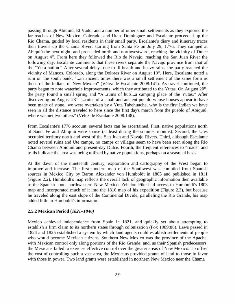
2.9
passing through Abiquiú, El Vado, and a number of other small settlements as they explored thefar reaches of New Mexico, Colorado, and Utah. Dominguez and Escalante proceeded up theRio Chama, guided by local residents in their small party. Escalante's diary and itinerary tracestheir travels up the Chama River, starting from Santa Fe on July 29, 1776. They camped atAbiquiú the next night, and proceeded north and northwestward, reaching the vicinity of Dulceon August 4 . From here they followed the Rio de Navajo, reaching the San Juan River theth
following day. Escalante comments that these rivers separate the Navajo province from that ofthe “Yuta nation.” After several delays due to ill health and heavy rains, the party reached thevicinity of Mancos, Colorado, along the Dolores River on August 10 . Here, Escalante noted ath
ruin on the south bank: “...in ancient times there was a small settlement of the same form asthose of the Indians of New Mexico” (Vélez de Escalante 2008:141). As travel continued, theparty began to note waterhole improvements, which they attributed to the Yutas. On August 20 ,th
the party found a small spring and “A...ruins of huts...a camping place of the Yutas.” Afterdiscovering on August 23 “...ruins of a small and ancient pueblo whose houses appear to haverd
been made of stone...we were overtaken by a Yuta Tabehuache, who is the first Indian we haveseen in all the distance traveled to here since the first day's march from the pueblo of Abiquiú,where we met two others” (Vélez de Escalante 2008:148).
From Escalante's 1776 account, several facts can be ascertained. First, native populations northof Santa Fe and Abiquiú were sparse (at least during the summer months). Second, the Utesoccupied territory north and west of the San Juan and Navajo Rivers. Third, although Escalantenoted several ruins and Ute camps, no camps or villages seem to have been seen along the RioChama between Abiquiú and present-day Dulce. Fourth, the frequent references to “roads” andtrails indicate the area was being utilized by native populations, perhaps on a seasonal basis.
At the dawn of the nineteenth century, exploration and cartography of the West began toimprove and increase. The first modern map of the Southwest was compiled from Spanishsources in Mexico City by Baron Alexander von Humboldt in 1803 and published in 1811(Figure 2.2). Humboldt's map reflects the overall lack of geographic information then availableto the Spanish about northwestern New Mexico. Zebelon Pike had access to Humboldt's 1803map and incorporated much of it into the 1810 map of his expedition (Figure 2.3), but becausehe traveled along the east slope of the Continental Divide, paralleling the Rio Grande, his mapadded little to Humboldt's information.
2.5.2 Mexican Period (1821–1846)
Mexico achieved independence from Spain in 1821, and quickly set about attempting toestablish a firm claim to its northern states through colonization (Fox 1989:88). Laws passed in1824 and 1825 established a system by which land agents could establish settlements of peoplewho would become Mexican citizens. Southern New Mexico was the province of the Apache,with Mexican control only along portions of the Rio Grande; and, as their Spanish predecessors,the Mexicans failed to exercise effective control over the greater areas of New Mexico. To offsetthe cost of controlling such a vast area, the Mexicans provided grants of land to those in favorwith those in power. Two land grants were established in northern New Mexico near the Chama
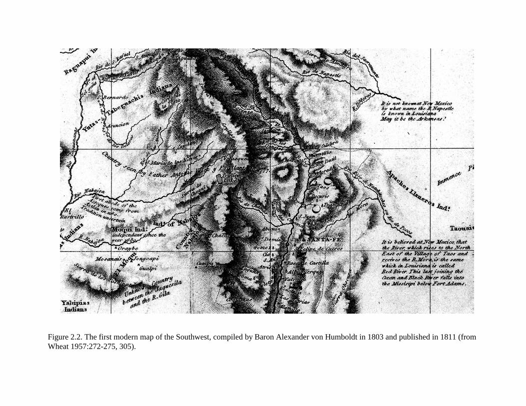
Figure 2.2. The first modern map of the Southwest, compiled by Baron Alexander von Humboldt in 1803 and published in 1811 (fromWheat 1957:272-275, 305).
Figure 2.3. Pike’s 1810 map of his expedition to the Internal Provinces of New Spain (northwestern New Mexico) was copied fromHumboldt’s manuscript map of 1803. All maps uncolored and bound into the back of Pike’s book (from Wheat 1957:299).
2.12
River, the Tierra Amarilla Grant (Julyan 1998) and the Piedra Lumbre Grant to the south.Texans tried repeatedly to tap into the trade of the Santa Fe Trail, but met with strong resistance(Sebastian and Levine 1989). American encroachment on Mexican territory in the Southwest,fueled by the philosophy of Manifest Destiny and the reality of land- and gold-hungry Americansquatters, continued, leading to the Mexican War of 1846–1848 (Vaughn 1923:128-133). Manyoutlying areas of New Mexico consisted of dispersed rancheria settlements that developedacequia systems to provide irrigation water to fields and gardens. Communities, such as TierraAmarilla, that developed in this way continued to be vital communities during subsequentAmerican political rule.
2.5.3 American Period (1846–present)
Santa Fe and the Department of New Mexico were captured by the Army of the West underGeneral Stephen Watts Kearny on August 18, 1846, after Mexican forces abandoned the city andterritory the day before (Vaughn 1923:133-154). New Mexico Territory and California wereformally ceded to the United States by the Treaty of Guadalupe Hidalgo in 1848. The early daysof American occupation were marked by several attempted uprisings, during which CharlesBent, the first Governor of New Mexico, was murdered at his home in Taos on January 19, 1847.The insurgency was put down by February 3, 1847, with the ring leaders killed in action or byexecution. New Mexico was governed by the U.S. Army through a series of puppet civiliangovernors until March 3, 1851, when James S. Calhoun was appointed as the first Governorunder the Organic Act that formally organized the Territory of New Mexico (Vaughn 1923:155-168). Settlements throughout the territory were under constant pressure from Indian resistance tothe American rule. Colonel E. V. Sumner was dispatched by Secretary of War Charles M.Conrad to develop an effective frontier against the Indians, particularly the Apache and Navajo,by constructing a series of fortifications where travelers were most vulnerable and Indian warparties might best be intercepted. Forts Fillmore (in the Mesilla Valley), Conrad (south ofSocorro) and Union (on the Mora River) were built first, garrisoned by troops from Santa Fe andsmaller villages. This marked the beginning of a concerted campaign against “wild” Indians,interrupted for a few years during the Civil War, that eventually led to the capture of large tractsof land and the development of the reservation system. Other than participation in the TaosUprising, the Pueblos remained peaceful; consequently, they were granted citizenship and theirexisting Spanish land claims were honored (Vaughn 1923:183).
Immediately following the War with Mexico, the U.S. Army began to undertake several decadesof extensive and increasingly detailed cartographic exploration of the new U.S. territories. Theseexpeditions began to provide detail about the distribution of Native American populations fromthe mid-nineteenth century onward. An 1857 Topographic Engineer map by Lieut. GouverneurWarren (Figure 2.4) identifies Menuaches/Muhuaches Indians in the Chama/Dulce vicinity,probably referring to the Utes.
By the mid-1850s, numerous Anglo settlements had been established across northern NewMexico, prompting Hispanic groups to organize. Land, mineral riches, and timber attractedmany into an area that was often considered hostile territory, due to aggressive indigenousgroups. Confrontations between settlers, Utes and Jicarilla Apache led to military intervention
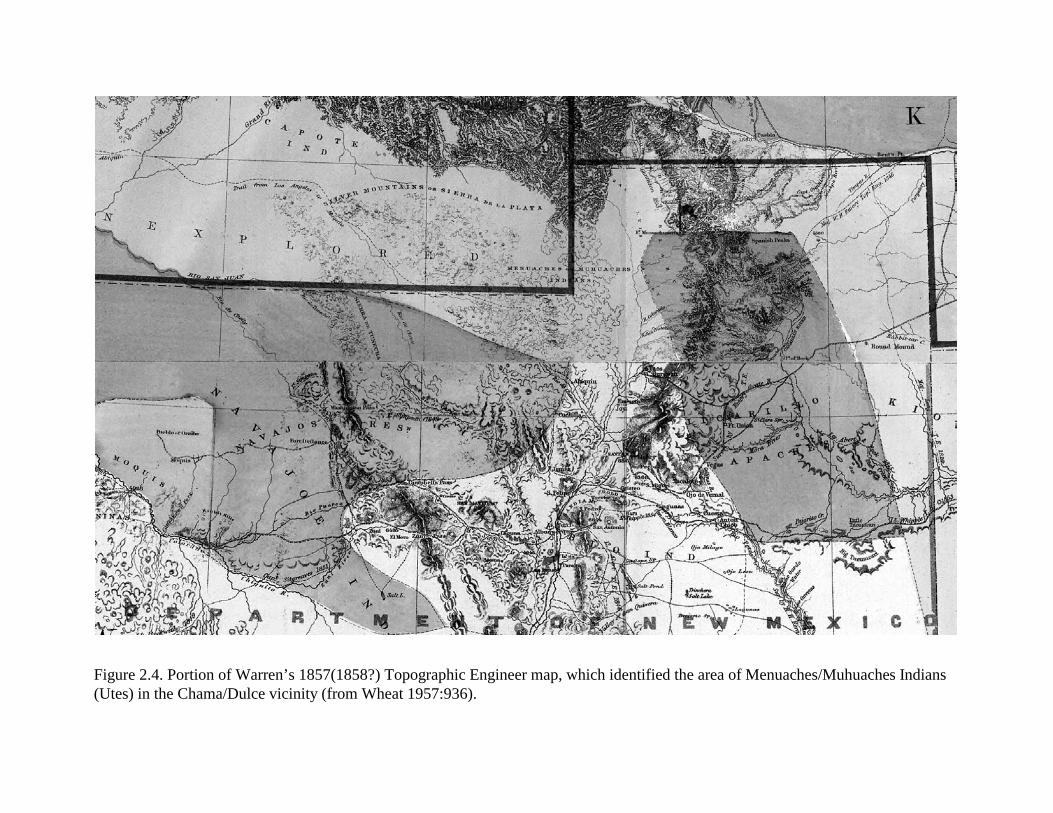
Figure 2.4. Portion of Warren’s 1857(1858?) Topographic Engineer map, which identified the area of Menuaches/Muhuaches Indians(Utes) in the Chama/Dulce vicinity (from Wheat 1957:936).
2.14
following the end of the Civil War. Early in the military’s renewal of comprehensive action,Camp Plummer was established near Los Ojos near Tierra Amarilla in 1866 by Col. Edward H.Bergman. The camp was renamed in 1868 as Fort Lowell, but was abandoned in 1869 (Julyan1998:57). Unlike the Mexican occupation, the United States actively pursued a program ofcontrolling the outlying regions of New Mexico, opening areas beyond the major rivers andtravel corridors to economic development. New Mexico was linked to the rest of the UnitedStates by railroads beginning with the Atchison, Topeka, and Santa Fe Railroad in 1879,following the old Santa Fe Trail, which opened the territory to ranchers, miners, loggers, andfarmers (Vaughn 1923:184-212). The 1866 General Land Office Map uses the term “Utahs” inthe same area (Figure 2.5). As late as the 1879 G.L.O. map, no communities are shown in theproject vicinity, but by 1886 a branch of the Denver & Rio Grande Railroad had been built andnumerous communities appear, including (east to west) Chama, Willow Creek, Azotea, Monero,Amargo, and Dulce.
By 1870, most Jicarilla had been resettled on the Maxwell Land Grant on the edge of the plainsin northeastern New Mexico but were forced to relocate when the grant was sold. In 1872 and1878, unsuccessful attempts were made to relocate the Jicarilla to Ft. Stanton and the newMescalero Apache reservation. Ultimately, the Jicarilla were allowed to settle near TierraAmarilla on a 900-square-mile reservation that had been set aside in 1874, but their annuitieswere suspended when they resisted the second attempt to relocate them south (Hodge 1960:631-632). Later in the century, references to the Jicarilla Apache note that their genesis myths refer tothe area around the Arkansas, Canadian and upper Rio Grande rivers (Mooney 1898).
Congress repealed the act that established the first reservation in 1880 and a new reservation wasdefined in the Rio Navajo country west of the continental divide. In 1883, the Jicarilla wereremoved to Ft. Stanton for five years until the tribe was allowed to return to a reservation in theTierra Amarilla area, established by Executive Order. During the last quarter of the centuryforest fires became a significant threat. In the 1870s, native peoples had begun to use fires todrive wild game to lower elevations where they were more easily hunted. The arrival of therailroads also encouraged the use of fires to clear forest cover and create meadows for grazingand improved access. Between 1880 and 1887, Euroamerican settlers had begun to encroach onthe public lands that were included in the later Jicarilla Reservation and rangelands were beingheavily overgrazed. By 1905, the Jicarilla population numbered 795 persons (Hodge 1960).
During this period of tribal relocation, the railroads had reached the northern border of NewMexico territory. In 1878, the Atchison, Topeka & Santa Fe Railroad entered New Mexico andcrossed Raton Pass as the New Mexico and Southern Pacific Company after a right-of-way battlewith the Denver & Rio Grande Railroad (D&RG). The D&RG shifted its route west to theheadwaters of the Rio Grande. Track was extended west, reaching Chama by 1880, and later toDulce, and south to Espanola and Santa Fe. It may have been during this time that the first use ofSite LA 133206 occurred. The entry of the railroads produced an increasing demand for coal,leading to the discovery and mining of extensive deposits in the Raton area and the San JuanBasin. By 1881, coal mining had begun at Monero, starting with several independent miners whoformed the Monero Coal and Coke Company in 1888.
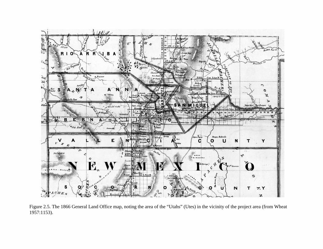
Figure 2.5. The 1866 General Land Office map, noting the area of the “Utahs” (Utes) in the vicinity of the project area (from Wheat1957:1153).
2.16
The mining opportunities at Monero attracted European immigrants, primarily Italians, withsome Irish and Poles who joined local Hispanics producing a town that numbered some 200families at its turn-of-the-century peak. Marshall (2001) notes that Monero had “...several stores,three cantinas, and a post office...three churches and cemeteries.” One of the larger cemeteries,associated with an adobe church is still maintained by local families and includes more than adozen identifiable graves, many of which identify members of the Caranta, Luchetti, Montoyaand Abeyta families. Economic statistics from 1929 indicate that the Monero coal mines werefourth highest in total state production following Gallup, Raton, and Cerillos/Carthage (Williams1932).
The modern community of Lumberton was established in 1881 as Amargo in response to thearrival of the railroad in Chama and became a center of the timber industry, supportingnumerous sawmills. Dulce was established in 1892, serving as the headquarters and tradingcenter for the Jicarilla Apache Indian Reservation (Julyan 1998).
The preceding discussion provides insights into historic events and record keeping that enablesome of the cultural resources within the project area to be better placed within a historiccontext. As will be discussed and evaluated within this report, many of the artifacts from thesesites reflect an early historic or protohistoric association or can be directly tied to theEuroamerican period, although not necessarily deposited by Euroamericans. With the intendedestablishment of the Jicarilla Apache Indian Reservation within the project area and historicaccounts of Jicarilla Apache groups occupying the general area in anticipation of the reservation,some of the historic Euroamerican artifacts may have been deposited by Jicarilla Apaches.Alternatively, once the railroad reached the Lumberton area, increased numbers ofEuroamericans and Hispanics ventured into the area and may account for the late nineteenth- andearly twentieth-century artifacts recovered from project sites.
3.1
3.0 RESEARCH DESIGN
by David H. Greenwald and Peter L. Eidenbach
Inventory survey along nine miles of US Highway 64 proposed for reconstruction by NMDOTbetween Lumberton and the road’s intersection with US Highway 84 identified 13 previouslyrecorded and five newly discovered archaeological sites (Kuru’es et al. 2007). Three of these sites,LA 133205, LA 133206, and LA 155234, required further investigation to mitigate potential adverseeffects from highway construction. These investigations included data recovery through surfacecollection and subsurface excavation, analysis, and interpretation. Data recovery was designed toaddress the research questions identified in the following research design. The research design anddata recovery plan were initially reviewed and approved by NMDOT staff. Once NMDOT commentswere addressed, the research design and data recovery plan was reviewed by HPD staff and theCultural Properties Review Committee (CPRC). The following research design (and plan ofwork–see Chapter 4) incorporates all comments received from the CPRC, HPD, and NMDOT.
The basic research questions about these sites concern site age, cultural affiliation, and function,which are grouped among five Problem Domains. Each Problem Domain is briefly discussed,followed by a list of Research Questions considered approachable given the composition of the sites,their physical and natural associations, and what is currently known of the area’s cultural history.Data Requirements needed to address specific Research Questions are then identified, includingapplication of specific field and analytical methods, archival research, and specialized analyticalapplications (e.g., archaeobotanic, chronometric, and trace mineral/sourcing).
3.1 Problem Domain 1: Cultural/Temporal Affiliations
Problem Domain 1 was designed to address two of the most basic archaeological research questions:when did the depositional event(s) occur and what cultural group(s) is responsible for the depositsthat comprise the project sites.
Cultural deposition represents formation processes that are directly related to activities conductedby humans; the residue that comprises archaeological sites is often the only footprint or tangibleremains left by previous groups, represented by discarded or lost artifacts and tools, remnants of pitfeatures and structures, and charred remains of structural elements, fuel, and food or othereconomically important resources. Recovery of specific forms of artifacts provides the primarymeans of defining the cultural affiliations of the materials that comprise archaeological sites.Dateable samples and artifacts considered to be diagnostic temporal indicators provide the primarymeans of defining the temporal parameters of when the site formation processes took place.Stratigraphic associations can be used to define relative sequences of activities and depositionalevents on sites. Combined, analyses of artifacts and artifact assemblages and dateable samples allowarchaeologists to define the cultural and temporal affiliations of sites. Successful application of thesetechniques requires the presence of culturally diagnostic artifacts, reliable dateable samples, and areasonable understanding of the cultural history of the area and surrounding region.

3.2
The approach largely relies on deductive reasoning once various options have been explored. Often,sites will lack culturally diagnostic artifacts or will not produce dateable samples, preventingdefinitive assignments from being made. Other sources that may aid archaeological interpretationinclude geomorphological investigation. The association between the physical composition of thesite formation processes and the geological deposits can be used to define broad periods during theHolocene when sites were occupied. For example, sites within stable areas on eroded surfaces mayrepresent an occupation that could have occurred over a broad period of time, whereas sites exposedupon surfaces of recent deposition or active deposition probably represent the remains of more recentformation processes. To assess the potential associations of the cultural materials with the geologicalformation processes, it is necessary to determine the current and past history of geological depositsin terms of their stability and age, and past environmental (and cultural) effects upon them. Definingthe nature of the deposits allows associated cultural deposits to be evaluated in a relative manner.Combined with other data sets (diagnostic artifacts and absolute dates), the geomorphologicalevaluation can prove significant when interpreting the temporal associations of site formationprocesses.
3.1.1 Research Questions
To address this problem domain, the following questions were posed.
1) Using all available means (diagnostic artifacts, chronological samples, andgeomorphological associations), what are the cultural and temporal affiliations of theproject sites?
2) What temporally and culturally diagnostic artifacts (ceramics, projectile points, historicartifacts) are present, and what do they imply regarding single or multiple site formationprocesses/occupations?
3) What temporal range of occupation is suggested by recovered dateable samples(radiocarbon assays, archaeomagnetic samples, obsidian hydration), and how do these dateintervals fit with other archaeological data sets?
4) If more than one occupation is represented, what is the temporal affiliation of eachoccupation? What is the cultural association of each occupation? To what extent cancultural affiliation be defined for distinguishable occupations?
5) Are stratified cultural deposits present, and what are the implications of such depositsregarding their temporal associations?
6) What are the estimated ages of the surface soils? Are the sites on the surface of youngersoils, located within stratified deposits, or on eroded older soil strata, and what are theimplications of these associations?
3.3
7) To what extent can distinct lithic material assemblages be associated with particular timeperiods? What morphological attributes, portions of assemblages, technology, and/ormaterials can be identified as distinct indicators of specific cultural/temporal associations?
8) What is the association of Euroamerican artifacts with lithic artifacts and thermal features?Do these artifacts and features represent multiple components deposited by different ethnicgroups or a single component deposited by indigenous groups who acquired Euroamericanitems?
3.1.2 Data Requirements
To address Problem Domain 1, all temporally and culturally diagnostic artifacts within each site’srecovered assemblage were collected and identified. Because individual artifacts and artifact classes(projectile points, ceramics, Euroamerican products) can be diagnostic, each category can be usefulin defining general associations (both temporal and cultural) and in addressing patterns exhibitedwithin site assemblages. The recovery and analysis of dateable samples (radiocarbon,archaeomagnetic, and obsidian) also proved important in our attempts to assign temporal affiliations,define site chronology, and distinguish between Archaic-age and Protohistoric-age and later artifactassemblages that may share similar attributes but represent considerable temporal differences.Analysis of hydration rates of obsidian was anticipated to provide approximate temporal associationssufficient to distinguish between Protohistoric/Historic- and Archaic-age assemblages. Althoughcultural affiliations of the project sites had not been well defined prior to the field phase,consideration was given that some sites may represent limited-use sites of the highly mobile Gallina,who also utilized much of the general project area. Until all data were analyzed, site affiliations mayhave been linked to any group who occupied the area between the Middle Archaic period and thetwentieth century. Dateable samples have helped identify multiple components and assemblageswithin mixed contexts. Stratigraphic associations and controlled recovery methods were needed whenassessing the presence of multiple component sites, even on sites with very little stratigraphicseparation between depositional events. Evaluating the geomorphological associations of the sitesalso aided interpretations about relative site age (early vs. late) and provided one line of evidence todistinguish between nondiagnostic Archaic-age deposits and Protohistoric/Historic-age NativeAmerican deposits. Therefore, geomorphological studies at the project sites were viewed as asignificant component of the general research approach, necessary for defining associations betweennatural and cultural events.
Morphological attributes, production methods, material composition, and technology associated withartifact production and use were proposed to define general-to-specific cultural (and temporal)associations. Assessment and recognition of diagnostic artifacts, technology and productionattributes, and use or application were examined for clues that enabled statements to be maderegarding the above-listed Research Questions. Specific analytical methods that were used for eachartifact category are discussed within the Plan of Work (see Chapter 4).
3.4
Radiocarbon assays provided baseline data for assigning sites to specific temporal periods. Sampleswere used to initially assess the potential for multiple occupations and multiple activity episodes ofeach site. The obsidian at Site LA 155234 has provided an opportunity to measure hydration ratesand evaluate reduction activities during the Archaic, Protohistoric, or other periods. A small obsidianassemblage was also obtained from Site LA 133206, from which a sample was submitted foranalysis, enabling additional perspectives on the nature of its components and their relative ages. Asingle example was recovered and submitted from Site LA 133205.
Archaeomagnetic sampling was proposed for thermal features. Although archaeomagnetic samplinghas largely been focused on Formative/Ceramic period sites, the curve has now been extendedthrough recovery of samples that date prior to and later than that period, making this dating methoda reasonable approach when attempting to define associations with the Late Archaic period andProtohistoric period.
All relative and absolute dating results (including diagnostic artifacts) were used to define thetemporal variability represented at each site and compare the results to the geomorphologicalinterpretations. As part of the temporal/cultural synthesis of the project, diagnostic artifacts providedthe primary means by which cultural affiliations were defined, to determine if more than oneoccupation or cultural group was represented, and to tie the occupation and temporal associationsof the project sites within current cultural/temporal schemes used in the Southwest.
3.2 Problem Domain 2: Subsistence and Economy
Non-agricultural/non-herding groups relied on various means by which to satisfy their dailysubsistence requirements. Since the three project sites were interpreted to represent non-agriculturalactivities presumably by non-sedentary groups, the focus of this problem domain has been placed onsubsistence activities use by mobile groups of hunters and gatherers. This problem domain addressesthe structure and organization of efforts applied to meet subsistence needs: procurement, acquisition,storage, processing, and consumption. Procurement and processing activities required specific toolsor tool kits; therefore, the artifact assemblages from each site were examined to address specifictypes of applications (cutting, sawing, grinding, pounding, etc.) and the materials, morphology, andcondition of the artifact assemblage used in the production of tools.
3.2.1 Research Questions
To address issues relating to subsistence and economy and the implications relating to subsistenceneeds as seen through artifact assemblages, the following questions were prepared.
1) What economic resources were exploited by occupants at each site? Do the exploitedresources represent locally available resources or were economic resources acquired fromelsewhere and brought to the sites?
3.5
2) What remains represent the collecting and gathering of floral resources? What elementscan define behavioral strategies associated with resources that were processed, stored, andconsumed?
3) What resources were acquired through hunting and trapping? What strategies were usedwhen large game was acquired?
4) What economic resources represent acquisition through exchange, including exchange withEuroamericans?
5) What resources were used for food, construction, firewood, tools, and clothing?
6) Based on the economic resources from each site, how was resource procurement and usescheduled? At what stage of development are plant taxa represented, and how does stageof development imply season of use? Similarly, what season of exploitation is representedamong faunal resources?
7) What procurement and processing methods of economic resources were employed?Specifically, what tool forms are present in the artifact assemblages to inform uponmethods used to procure plants and animals, and how were these resources processed inpreparation for consumption? What tool production methods were employed, and howwere tools used? What does tool condition imply about acquisition and processing ofresources, or changes in strategies?
8) What evidence exists to support storage of resources? What types of storage facilities wereused?
3.2.2 Data Requirements
Floral resources become available seasonally, with some suitable for exploitation in the Spring.Others provide fruits, seeds, or roots that can be collected as economic resources during Summer orFall months, with a few available year-round. Faunal resources are generally available year-round,with increased numbers available following birth of offspring. In northern New Mexico and southernColorado, some movement of fauna occurs with changes of season, such as elk herds that move intolower elevations during winter months when snow cover disrupts access to browse generallyavailable resources in higher elevations. Vast movements of herd animals over long distancesgenerally does not occur in this area, but may have during the Archaic period when bison roamedover many areas of the Southwest. For hunters and gatherers, adaptation to a mobile lifestyle wasessential in order to exploit resources as they became available or when resources were over-exploited. Likewise, development of storage facilities, focus upon resources that possessed storageproperties, and processing methods that enabled foods to be stored were important considerationswithin the subsistence system. Examination of recovered floral and faunal remains from the projectsites was anticipated to provide insights into what economic resources were exploited, how they wereexploited, and the time of year that is represented by the remains.
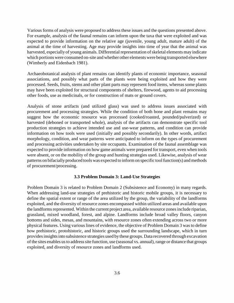
3.6
Various forms of analysis were proposed to address these issues and the questions presented above.For example, analysis of the faunal remains can inform upon the taxa that were exploited and wasexpected to provide information on the relative age (juvenile, young adult, mature adult) of theanimal at the time of harvesting. Age may provide insights into time of year that the animal washarvested, especially of young animals. Differential representation of skeletal elements may indicatewhich portions were consumed on-site and whether other elements were being transported elsewhere(Wimberly and Eidenbach 1981).
Archaeobotanical analysis of plant remains can identify plants of economic importance, seasonalassociations, and possibly what parts of the plants were being exploited and how they wereprocessed. Seeds, fruits, stems and other plant parts may represent food items, whereas some plantsmay have been exploited for structural components of shelters, firewood, agents to aid processingother foods, use as medicinals, or for construction of mats or ground covers.
Analysis of stone artifacts (and utilized glass) was used to address issues associated withprocurement and processing strategies. While the condition of both bone and plant remains maysuggest how the economic resource was processed (cooked/roasted, pounded/pulverized) orharvested (deboned or transported whole), analysis of the artifacts can demonstrate specific toolproduction strategies to achieve intended use and use-wear patterns, and condition can provideinformation on how tools were used (initially and possibly secondarily). In other words, artifactmorphology, condition, and wear patterns were anticipated to inform on the types of procurementand processing activities undertaken by site occupants. Examination of the faunal assemblage wasexpected to provide information on how game animals were prepared for transport, even when toolswere absent, or on the mobility of the group and hunting strategies used. Likewise, analysis of wearpatterns on bifacially produced tools was expected to inform on specific tool function(s) and methodsof procurement/processing.
3.3 Problem Domain 3: Land-Use Strategies
Problem Domain 3 is related to Problem Domain 2 (Subsistence and Economy) in many regards.When addressing land-use strategies of prehistoric and historic mobile groups, it is necessary todefine the spatial extent or range of the area utilized by the group, the variability of the landformsexploited, and the diversity of resource zones encompassed within utilized areas and available uponthe landforms represented. Within the current project area, available resource zones include riparian,grassland, mixed woodland, forest, and alpine. Landforms include broad valley floors, canyonbottoms and sides, mesas, and mountains, with resource zones often extending across two or morephysical features. Using various lines of evidence, the objective of Problem Domain 3 was to definehow prehistoric, protohistoric, and historic groups used the surrounding landscape, which in turnprovides insights into subsistence strategies used by these groups. Data recovered through excavationof the sites enables us to address site function, use (seasonal vs. annual), range or distance that groupsexploited, and diversity of resource zones and landforms used.
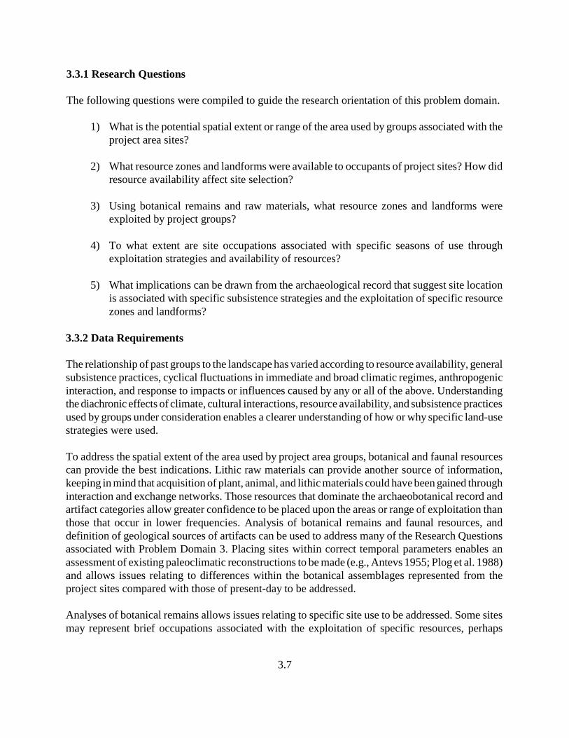
3.7
3.3.1 Research Questions
The following questions were compiled to guide the research orientation of this problem domain.
1) What is the potential spatial extent or range of the area used by groups associated with theproject area sites?
2) What resource zones and landforms were available to occupants of project sites? How didresource availability affect site selection?
3) Using botanical remains and raw materials, what resource zones and landforms wereexploited by project groups?
4) To what extent are site occupations associated with specific seasons of use throughexploitation strategies and availability of resources?
5) What implications can be drawn from the archaeological record that suggest site locationis associated with specific subsistence strategies and the exploitation of specific resourcezones and landforms?
3.3.2 Data Requirements
The relationship of past groups to the landscape has varied according to resource availability, generalsubsistence practices, cyclical fluctuations in immediate and broad climatic regimes, anthropogenicinteraction, and response to impacts or influences caused by any or all of the above. Understandingthe diachronic effects of climate, cultural interactions, resource availability, and subsistence practicesused by groups under consideration enables a clearer understanding of how or why specific land-usestrategies were used.
To address the spatial extent of the area used by project area groups, botanical and faunal resourcescan provide the best indications. Lithic raw materials can provide another source of information,keeping in mind that acquisition of plant, animal, and lithic materials could have been gained throughinteraction and exchange networks. Those resources that dominate the archaeobotanical record andartifact categories allow greater confidence to be placed upon the areas or range of exploitation thanthose that occur in lower frequencies. Analysis of botanical remains and faunal resources, anddefinition of geological sources of artifacts can be used to address many of the Research Questionsassociated with Problem Domain 3. Placing sites within correct temporal parameters enables anassessment of existing paleoclimatic reconstructions to be made (e.g., Antevs 1955; Plog et al. 1988)and allows issues relating to differences within the botanical assemblages represented from theproject sites compared with those of present-day to be addressed.
Analyses of botanical remains allows issues relating to specific site use to be addressed. Some sitesmay represent brief occupations associated with the exploitation of specific resources, perhaps
3.8
repeatedly used seasonally (ephemeral camp sites) as the specific resource became available.Alternatively, greater duration of use when numerous forays were conducted to exploit a variety ofresources (base camps) may be represented by a broader array of botanical resources that can beexploited at approximately the same time of the year but representing a broader range of seasonalavailability. The association between the resources that were exploited and the surroundinglandforms and resource zones can be evaluated through frequencies of occurrence and variability ofbotanical and lithic resources represented, requiring that analyses of both floral remains and lithicitems be undertaken.
3.4 Problem Domain 4: Geomorphological Associations and Implications
Due to the geological history of the project area, soils derived from colluvium and stream alluviumare likely to be fairly recent, with cultural deposition recent as well. Understanding thegeomorphological processes that have contributed to the formation processes at each site is essentialto the project. As considered under Problem Domain 1, the project sites may be affiliated with anycultural group from the Middle Archaic period to Historic times, including the highly mobile Gallina.It is possible that the historic glass and cans at Site LA 133206 may be associated with Euroamericanor Native American activity at this site. As proposed, it was considered a necessary requirement todetermine if any of the sites possessed culturally stratified, superimposed deposits. With adetermination regarding the relative age of the soils at each site and the presence/absence of stratifiedcultural deposits, efforts were focused toward defining the temporal range of the cultural deposits,using the most appropriate chronometric controls available.
3.4.1 Research Questions
To guide the research orientation of this problem domain, the following questions have been posed.
1. What are the estimated ages of the surface soils? Are cultural deposits positioned on thesurface of younger soils, within the soil horizon, or do components extend downward intoolder soil strata?
2. Do the sites have any significant depth of cultural deposits and/or stratification? To whatextent can superimposed components be defined?
3. What are the implications of the cultural deposits to the estimated age of the soils in theproject area?
4. What natural processes have affected the integrity of cultural deposits (e.g., frost,bioturbation, etc.)?
3.9
3.4.2 Data Requirements
Emphasis was placed on defining the geomorphology at each of the project sites to allow areasonable reconstruction of the cultural and natural formation processes. Steve Hall provided an in-field examination of the geomorphology and assessed the age of the landforms upon which the siteswere situated. Soil data were compared with recovered archaeological data and dates received forthe sites to further evaluate field observations. Backhoe trenches provided linear exposures fromwhich the age of soils, the presence of stratified deposits, and the affects of natural processes uponthe cultural deposits were assessed.
3.5 Problem Domain 5: Historic Aboriginal vs. Euroamerican
Site LA 133206 possesses both a lithic assemblage and an assemblage of Euroamerican (glass andmetal) artifacts. Although it is possible that the site represents two distinct temporal/culturalcomponents, many of the Euroamerican artifacts have production ages that extend from the latter partof the nineteenth century, a time when Jicarilla Apache are known to have used the general projectarea. The mixed artifact assemblage may be related to a period that predates the establishment of theJicarilla Apache Indian Reservation (1887), when the Jicarilla had moved to the general area awaitingthe formal creation of the reservation. The historic artifact scatter at Site LA 133206 occurred indirect association with some of the thermal features, suggesting a direct correlation between thefeatures and the artifacts. Mixed assemblages of artifacts during this period is possibly a morecommon occurrence than has been recognized. For groups that once relied upon access to highquality lithic sources (specifically obsidian), alternative sources were sought when access wasrestricted by Euroamerican encroachment. One example was given by Hualapai Indians at Hackberry,Arizona, in which bottles were obtained from nearby dump sites in place of obsidian when accessto the obsidian was restricted or became too risky (Mercer and Ballagh 1996). When possible workedglass was observed at Site LA 133206, a similar acquisition strategy was considered, with the spatialassociation between the historic items and the thermal features reflecting direct temporal and culturalassociations. Furthermore, Site LA 133206 was reported to have a sandstone feature, approximately4 m in diameter, which lay beyond the right-of-way. Its description (Kuru’es et al. 2007) is similarto others for “tipi rings.” However, inspection of the sandstone feature disclosed that it wasconsiderably larger than originally reported, possibly representing structural remains of aEuroamerican structure. Numerous examples of wickiups or tipi rings are widely known to the east,where many were excavated during studies associated with the construction of the Ute Reservoir onthe Canadian River (Hammack 1965), to which some have been ascribed to the Jicarilla Apache. Thecontention that the site may represent a late historic aboriginal site is open to question, yet the lithicassemblage has provided some indications that it reflects late associations.
3.5.1 Research Questions
The following questions have been compiled to guide the research orientation of this problemdomain.
3.10
1) What is the spatial (physical) relationship of the historic artifact scatter to the thermalfeatures and flaked and ground stone artifacts? Are they discrete, intermixed, or directlyrelated (historic artifacts within the thermal features)?
2) If the artifacts represent two discrete occupations, what is the function and temporalassociations of the two occupations?
3) To what extent do the historic artifacts represent modified items, e.g., flaked glass,modified metal containers, cut metal/tinklers, etc., and what percentage of the assemblageexhibits modification?
3.5.2 Data Requirements
Investigations required close scrutiny of the spatial associations of the thermal features and historicEuroamerican artifacts. Excavations of features and areas adjacent to the features were conductedto determine if a direct relationship between the use of the features and artifacts, including artifactswithin the features, existed. Recovery of dateable samples were undertaken to clarify temporalassociations between the features and historic Euroamerican artifacts. Analysis of the historic itemsrequired that each item be examined for modification (worked edges of glass, cut or perforated metal,modified metal containers) resulting from secondary use. The presence of modified Euroamericanartifacts were evaluated along with dateable samples and archaeobotanical samples from thermalfeatures to address issues concerning use of the features, other associated activities, andtemporal/cultural associations. Glass artifacts, in particular, were examined for modification in theform of edge preparation for cutting and scraping use; glass items from subsurface contexts wereexamined for patterned modification and compared with items from surface contexts to evaluate ifsurface items possessed intentional or natural edge modification. Metal items were examined formodifications to the original form and production of other items from containers, such as tinklers ormetal arrow points.
4.1
4.0 PLAN OF WORK
by David H. Greenwald
4.1 Field Excavation Methods
The three project sites—LA 133205, LA 133206 and LA 155234—share similar surface expressionsyet reflect three or more different temporal/cultural affiliations. All three sites were initially recordedas consisting of surface artifact scatters with associated thermal features or stains (Kuru’es et al.2007; Marshall 2001). Sites LA 133205 and LA 133206 were described as having thermal featurespartially exposed in the existing road cut (Marshall 2001); in fact, dark stains were observed asoriginally described, leading to the expectation that other similar types of features could beanticipated at both of these sites. Site LA 155234, located in newly acquired right-of-way, did notpossess erosional exposures or road cuts to provide information on potential subsurface deposits andcultural associations. The site appeared to be somewhat eroded, resulting in the exposure of surfaceartifacts and a single cultural stain when first discovered (Kuru’es et al. 2007) and a second stainwhen data recovery efforts were initiated. As presented in Chapter 3, five problem domains wereidentified and considered reasonable and approachable objectives based on the composition of thethree project sites. The following proposed field excavation methods were proposed to adequatelyand appropriately investigate each site and address their research potential as indicated by theirsurface expressions. The proposed field approach included the application of provenience controls,surface collections, production of site and feature maps, excavation strategies, screening andrecovery methods, recording of profile and stratigraphic data, geomorphological assessment of eachsite, use of mechanical excavation methods, and photography, drawings and narrative descriptionsas recording methods. The application of each implemented method is discussed below.
4.1.1 Site Mapping
Site plan maps were produced of each site using a Leica TS 800 Total Station, with built-in datarecording system; Leica Geo Office software was used to generate text files and converted toshapefiles using ArcGIS Desktop 9.2. The plan map includes the right-of-way boundaries, existingdisturbances (e.g., the highway, bar-ditch, cut slope, fence line, etc.), site datum, locations of handand mechanical excavation units, site grid, the location and shape of all features, artifactconcentrations, point-provenienced artifacts, site boundaries, and the relationship of the site tonearby physiographic features. Each site map incorporates a map legend and metric scale.
4.1.2 Surface Collections
Controlled surface collections were accomplished using a grid based on the UTM system. Surfaceartifacts were collected according to 1 × 1 m units or by their point provenience. Prior to initiatingany collecting, all surface artifacts were pin-flagged to visually define their distribution anddetermine whether collections would be made by 1 × 1 m units or according to their pointprovenience. Widely dispersed surface artifacts were collected by point provenience.
4.2
4.1.3 Feature Excavations
All features visible on the surface were completely excavated, with each artifact concentrationsampled using a 1 × 1-m control excavation unit to determine if these concentrations possessed depthand/or stratified deposits. The horizontal extent of each feature was initially defined by removingvegetation and overburden; an area sufficiently large enough to expose the entire feature’s limits wasexcavated using whole excavation units (e.g., 1 × 1 m, 2 × 2 m, etc.). The feature was then mappedin plan view. Each feature was then excavated in profile (approximately half) in order to prepare aview of the cross section, which was drawn with each stratigraphic unit described using soiltaxonomic nomenclature and a Munsell Soil Color chart to characterize the sediments. Scaledrawings of the feature profiles were produced. Once excavation of each feature had been completed,a plan-view and cross-section drawing were prepared; cross sections were produced to showirregularities within features. All features, including any remnants of structural features, wererecorded in narrative noting size, shape, construction detail, fill composition and sequence, probablefunction, associated artifacts and samples recovered, and relationship to other features and artifactactivity areas. Separate feature forms were prepared for each feature. All features were numberedand labeled to correspond to the feature form.
4.1.4 Excavation Levels
Excavation of all features and control units was conducted by arbitrary levels until natural strata weredefined. Each arbitrary level was 10 cm. When natural strata exceeded 10 cm in thickness, they alsowere excavated according to 10 cm levels.
4.1.5 Screening
Sediments removed from all hand-excavation units were screened using quarter-inch (6.35-mm)mesh. Fill from thermal features was evaluated as to its associations; fill associated with use of thefeature was collected for laboratory analysis. Additionally, sediments from features were screenedthrough eighth-inch (3.175-mm) mesh.
4.1.6 Stratigraphic Profile Recording
Stratigraphic profiles were drawn to scale, photographed, and described in narrative. Sediment andcultural deposit descriptions included sediment color, texture, moisture content, nature of inclusions,organic content, and an inventory of cultural materials. Soil taxonomic nomenclature and a MunsellSoil Color chart were used to characterize the sediments.
4.1.7 Mechanical Excavations
Backhoe trenches were used to expose stratigraphy and to locate subsurface features and culturaldeposits. The front bucket of the backhoe and a 5-foot-wide, smooth backhoe bucket was used to
4.3
horizontally strip large areas. Procedures associated with backhoe trenching and mechanicalstripping conformed to the following standards:
a) All surface artifacts were collected prior to excavation of trenches or scraping areaswith mechanical earth-moving equipment;
b) Depths for backhoe trenches conformed to OSHA standards for excavation safety (29CFR 1926, Subpart P);
c) Each trench or stripping area was documented as to its location, depth, soil profile,artifact yield, and geomorphic character;
d) Both sides of each backhoe trench were cleaned with a shovel or trowel and the profileinspected for cultural features and material remains;
e) At least one profile was documented in narrative, with a profile drawing produced andphotographs taken. Sediment deposit descriptions included sediment color, texture,moisture content, nature of inclusions, organic content, and an inventory of culturalmaterials;
f) The excavated area was examined after the removal of each extracted bucket-load tolimit disturbance to cultural features and other sensitive remains; and
g) The backdirt was examined for the presence of artifacts.
4.1.8 Special Samples: Collection Methods and Strategies
Special samples were collected from various contexts to provide a suite of samples for laterprocessing and analysis. Not all collected samples were analyzed; selection of samples for analysiswas based upon which samples had the greatest potential to address research objectives of theproject. Among the samples that were routinely collected when present were archaeobotanical(pollen and macrofloral) and chronometric (radiocarbon and archaeomagnetic).
Archaeobotanical samples were collected from contexts of high integrity, usually from the fill of pitfeatures. Specific locations of the collected samples were made on a judgmental basis, using thefollowing criteria: (1) sediments most likely to represent use context; (2) sediments rich in organicmatter; (3) samples in undisturbed contexts; and (4) samples from sealed contexts, such as underartifacts at the base of features or from sediments that were rapidly covered and preserved. Samplingmethods followed recommended procedures outlined by Fish and Miksicek (1982), with standardsize for macrobotanical samples of 2 liters. Samples were placed in large paper bags, which allowthe samples to dry rather than mildew. Approximately 4 to 6 tablespoons of sediment were collectedfor pollen samples; each sample was placed in a sealed plastic bag.
4.4
Radiocarbon samples were collected when sufficient quantities of organic matter, primarily woodcharcoal, carbonized annuals, or burned bone, were present. All samples were placed in aluminumfoil and sealed. Information on each sample was recorded regarding its stratigraphic associations andcontextual integrity; these data were used when selecting samples for analysis, focusing on the bestcandidates. Archaeomagnetic sampling was conducted when thermal features exhibited sufficientlevels of burning. Recent extension of the Southwest Curve into the Late Archaic and Protohistoricperiods now makes application of this dating technique appropriate for non-ceramic age sites.Samples were collected and analyzed by Eric Blinman and Jeff Cox, Museum of New Mexico.
4.1.9 Geomorphological Studies
Definition of the geomorphology off- and on-site was considered fundamentally important tounderstanding the general temporal associations of site formation processes. Excavation units andbackhoe trenches were examined by Steve Hall to aid in defining the age of sediments upon whichand into which cultural deposition has occurred. Sediments at Site LA 155234 appear to be mucholder than sediments at Sites LA 133205 and LA 133206, which may have been formed in the LateHolocene. The young age of the soils was considered of paramount importance in aidinginterpretations regarding presence of Euroamerican artifacts in direct association with itemsproduced by Native Americans, and has given reason to reconsider the previously suggested age ofthe lithic assemblages as Archaic. Profile exposures were examined to define as precisely as possiblethe age of the sediments and address the associations between the sediments and the artifacts.
4.1.10 Post-Excavation Mechanical Excavation
Mechanical stripping was employed following excavations of areas in which features or activityareas had been defined. The stripping served the purpose of disclosing features not found during thetesting, trenching, or excavation, and provided closure to the original proposed strategies and a checkon the reliability of the excavation sampling design. Features exposed during mechanical strippingwere mapped in relation to the site datum. All features were fully described and samples of datablespecimens and artifacts were collected. All discovered anomalies were tested, and all anomalies thatrepresented features were fully excavated following the previously described procedures.
4.1.11 Site Backfilling
Each site was backfilled using a backhoe. The trenches and excavation areas were in-filled andleveled, but were not water compacted. The bottom of the excavation units and trenches were notlined with landscape cloth or marked in any other fashion to indicate depth of disturbance, becausethe sites will be destroyed by construction.
4.1.12 Photographs
Photographs included digital formats. Digitally captured images enable photographs to beimmediately accessible to field personnel and easily included within the text of reports. Black-and-
4.5
white prints have been produced for archival storage. At a minimum, photographs were taken of eachfeature, feature profile, features in various stages of completeness, and work in progress.
4.1.13 Human Burials
Based on the surface expressions of the sites under consideration, human burials were notanticipated. Provisions were made in advance if human burials were encountered, requiring that allwork stop immediately in the area of the discovery and authorities be notified. The notificationprocess included contacting local law enforcement pursuant to 4.10.11 NMAC and the NMDOTProject Director. A determination would be made with NMDOT personnel whether or not the humanremains could be left in place. If excavation of human burials proved necessary, such excavationwould only have been conducted pursuant to 4.10.11 NMAC.
4.2 Laboratory Procedures and Analytical Methods
An examination of the surface of the three project sites indicated that flaked stone, ground stone, andhistoric artifacts (glass, ceramics, and metal) were present and also recovered from subsurfacecontexts. No Native American ceramics were previously reported at any of the sites; however, aconcentration of gray micaceous sherds was found at Site LA 155234 during site gridding. Thefollowing processing and analytical methods were implemented.
4.2.1 Material Receiving
All recovered/collected materials were submitted to the Four Corners Research laboratory where theywere inventoried and checked against the Bag List (field inventory record). Materials were processedand prepared for submission to analysts, specialists, and consultants.
4.2.2 Material Cleaning
Each artifact category recovered was cleaned initially by using a series of washes, using only waterand soft brushes. When this process proved unsuitable for sufficiently cleaning the artifacts andmeeting the needs of the analysts, additional cleaning was done using a weak 10-percent solution ofmuriatic acid on those items or portions of items that required further cleaning. Following use of theacid wash, the artifacts were rinsed with clean water. All artifacts were thoroughly dried beforeplacing them into bags. Once the cleaning process had been completed, the artifacts were given tothe appropriate analysts.
Although limited testing to detect the presence of blood residues on flaked stone tools fromsubsurface contexts was proposed during laboratory processing, few suitable items were recoveredfrom subsurface contexts. Therefore, the process was implemented.
4.6
4.2.3 Flaked Stone Analysis
All flaked stone artifacts were analyzed as to function, technology, morphology, material type, andsource. Use-wear analysis plays an integral role in determining tool function. Optical magnification(hand lens and binocular microscope) were used when needed for identification of use wear. Use-wear analysis of flaked items was restricted to those items recovered from subsurface contexts.Typologies and approaches followed traditional applications derived from previous analyticalapproaches used as part of the Dolores Archaeological Program (Phagan and Hruby 1984). Debitageattributes that were recorded include material type, quality, and source; size; platform; condition;flake type; cortex; and special treatment. Core and tool attributes were more encompassing, with theaddition of measurements, weight, reduction stage and characteristics, and use-wear presence andtype. Projectile points were closely examined and identified as to type as an additional method ofaddressing temporal associations (Problem Domain 1, Research Questions 1 and 2). Analysis of theflaked stone assemblage was used to address issues regarding site and feature function (ProblemDomain 2, Research Questions 2 and 3), resource exploitation (Problem Domain 2, ResearchQuestion 7), and raw-material acquisition strategies (Problem Domain 3, Research Questions 1 and3).
A small but growing set of data are being gathered on the cultural affiliation of nonceramicassemblages based on lithic attributes (cf. Brown and Hancock 1992; Greenwald 1997; Seymour2002) in the Southwest. Although some distinguishable patterns between assemblages can be made,they are usually based on a large sample. The most discriminating variables are material type,material type diversity, heat treatment, and artifact types. However, most technological factors arevery similar among mobile populations, providing little basis for determining cultural association.Only Site LA 155234 possessed a lithic assemblage of sufficient size to attempt to address researchquestions focused on identifying temporal/cultural affiliations, and allowed detailed morphological,technological, and functional implications to be made. The efforts made during this project haveprovided at least a background for future studies in support of this research.
4.2.4 Ground Stone Analysis
All ground stone artifacts were analyzed as to function, technology, morphology, material type, andsource. Form often is suggestive of processing methods and can indicate types of resources that wereprocessed. Form, when coupled with use-wear analysis, can inform on tool function. Opticalmagnification (hand lens and binocular microscope) was used when needed for identification of usewear on such items as cobble manos, handstones, and metate fragments. Typologies and approachesfollowed traditional applications derived from previous analytical approaches used as part of theDolores Archaeological Program (Phagan and Hruby 1984). Analytical variables included materialtype, source and texture; tool and use surface measurements; condition; use wear type and extent;and manufacture and refurbishing techniques.
Because certain forms of ground stone tools can be temporally sensitive, the assemblage was closelyexamined regarding form as an additional method of addressing temporal associations (Problem
4.7
Domain 1, Research Questions 1, 2, and 7). Analyses of the ground stone assemblages were alsoused to address issues regarding site and feature function (Problem Domain 2, Research Questions1 and 2), resource exploitation (Problem Domain 2, Research Question 7), and raw-materialacquisition strategies (Problem Domain 3, Research Questions 1 and 3).
4.2.5 Historic Artifact Analysis: Glass, Ceramics and Metal
Analyses of the historic artifacts were conducted to gather clues as to whether these artifactsrepresent goods/items acquired and used by Native Americans or items disposed of byEuroamericans, to address site function and temporal associations. Attributes were gathered throughdetailed analyses of the materials, focusing on production methods, material composition,modifications such as modified (flaked) edges of glass shards, or modification or reshaping of metalcontainers to serve other functions or to serve as ornaments or other tools. Comparisons of theproject assemblage were made with other Euroamerican and Native American assemblages (e.g.,Gilpin 1993; O’Mack 2005) to evaluate the depositional associations.
The analysis format followed that developed for the Navajo Indian Irrigation Project, whichclassified artifacts in terms of material type and method of manufacture, and function. Additionally,cans were further categorized in terms of shape (round, rectangular, other) and technology (hole-in-cap, hole-in-top, internal friction lid, external friction lid, hinged-lid, key-strip-opened, sanitary,other). Can sizes are useful for dating; therefore, dimensions were recorded to the nearest sixteenthof an inch for complete or nearly complete (non-crushed) cans. Glass artifacts were categorized asto color and morphology (bottles, jars, canning jars, tableware, window glass, mirrors, lanternglobes, stoppers, beads, other). Because a likelihood that the historic artifact assemblage was relatedto Native American activities, the glass assemblage was examined to determine if any shards wereflaked to produce useable edges or used as cutting/scraping tools. Comparisons of possible workedglass specimens were attempted between surface and subsurface contexts. Although it is oftendifficult to distinguish sharpening and use from simple mechanical fracture, certain types offragments occasionally demonstrate intentional modification, such as spokeshave resharpening anduse of the interior curve of bottlenecks. The presence of such flaking patterns would strongly suggestan association with Historic-period Native Americans on the site. Ceramics were categorizedaccording to source (e.g., European, American, Native American), production technique and materialtype (porcelain, hard paste, stoneware, other).
The classification of item function followed South’s (1977) method used to distinguish amongartifact (generally functional) categories, including domestic artifact group, architecture group,clothing group, personal group, tool group, hardware group, and other. The domestic artifact groupwas further divided into food and drink, hygiene, medicine and pharmaceutical, tableware, and other.In addition to defining the object’s original function and period of manufacture/use, efforts were alsomade to define secondary function. Laboratory examination of each item attempted to address datesof manufacture, manufacturing technology, and presence of modification (and what function thosemodifications served). A review of context was made to determine if associations with thermalfeatures and other activity areas existed, and assess those associations. The purpose of conducting
4.8
the historic artifact analysis was to aid the definition of temporal associations as they relate to projectsites (Problem Domain 1, Research Questions 1, 2, 4, and 8), and to determine if Euroamerican itemswere obtained by Native Americans (Problem Domain 2, Research Question 4), and how they wereused (Problem Domain 5, Research Questions 1 and 3).
4.2.6 Faunal Analysis
Faunal remains recovered from the project sites were sorted according to taxa, followed by a moredetailed inventory and examination of the assemblage for worked bone and utilized bone. Items wereexamined for indications of burning or other cultural modifications (shaped, utilized, cutting, markscaused by processing, etc.) that may represent use for food or other cultural purposes (e.g., tools).Context of recovered items was considered during the analysis; for example, faunal remains fromuse-contexts (within deposits that represent feature use as opposed to post-abandonment deposits)may indicate exploited resources even though no burning or other modification is present. Examplescould include faunal remains from lower portions of pits or on use surfaces. Taxa that wererepresented by limited numbers of remains or remains from specific sections of the animal wereassessed with regard to butchering strategies and transporting costs. Small amounts of identifiablelarge mammal bone can indicate distinct patterns that are consistent among hunting societies fromArchaic to ethnographic times (Wimberly and Eidenbach 1981). The faunal analysis was anticipatedto address issues relating to subsistence (Problem Domain 2, Research Questions 1, 3, 5, and 6) andsupport issues relating to land-use strategies (Problem Domain 3, Research Questions 1, 2, 4, and5).
4.2.7 Macrobotanical and Pollen Analyses
Complementary pollen and macrobotanical samples were taken when sufficient amounts wereavailable. Although the standard size for macrobotanical samples was 2 liters, smaller samples werecollected if sufficient amounts could not be retrieved. Samples were routinely collected, with theintegrity of context evaluated. Preferred proveniences were sealed contexts from below artifacts orstones on surfaces or in pits, from in-use contexts such as the bottom of pits, and from other culture-bearing strata. Pollen washes were proposed from artifacts with high integrity of cultural association,but no suitable specimens were discovered.
Archaeobotanical studies were conducted by Paleo Research, who analyzed the samples andprepared a descriptive and interpretive report. The main focus of the archaeobotanical studies wasto address questions associated with paleoeconomy and subsistence (Problem Domain 2, ResearchQuestions 1, 2, 4, 5, 6, and 8). Plant taxa present in the archaeobotanical record was examined toallow questions relating to how different environmental zones were exploited and how exploitationstrategies were scheduled (Problem Domain 3, Research Questions 1, 2, 3, 4 and 5), and aided inaddressing issues relating to the mobility of groups.
4.9
4.2.8 Chronometric Sample Analyses
Three dating techniques—radiocarbon, archaeomagnetic, and obsidian hydration—were employedduring this project to generate a series of date ranges for each site. Radiocarbon samples (anddiagnostic artifacts) collected from each project site serve as the primary dating method. Charredwood was the principal item submitted for analysis. Archaeomagnetic dating was used when suitablesamples could be collected from features that were considered Late Archaic period in age or later.Obsidian hydration was also used on sites that possessed obsidian; this dating technique wasexpected to aid interpretations regarding site assemblages and relative temporal data. Obsidian wasrecovered from Sites LA 133206 and LA 155234. Specimens of recovered obsidian were alsoidentified as to their source to aid interpretations regarding resource procurement and acquisitionstrategies. Although it was recognized that dating accuracy may not be precise due to the location’slocal environmental parameters, comparisons have revealed relative periods in which flakes wereproduced (e.g., Archaic, Protohistoric, or other). A general seriation of the rind thicknesses haveprovided additional perspectives on the nature of site components and their relative age. The primarypurpose of conducting chronometric analyses was to address Problem Domain 1, Research Questions1, 3, and 4, which focus upon chronology building and defining specific temporal associations foreach site.
4.2.9 Data Management
Project data management began with clear, consistent communication among project administratorsand task workers, and extended through efficient and well-directed supervision and support.Interaction and communication among Four Corners Research key project personnel and NMDOTproponents has kept unforeseeable circumstances in line with project goals and methods outlinedherein. Good record-keeping skills, in concert with multiple record checks, was in place during theentire undertaking—administration, fieldwork, laboratory/analytical process, report production, andproject curation—to facilitate the careful control of project data.
Field forms and excavation methods were reviewed by all field personnel prior to the start offieldwork, for consistent application. During fieldwork, the Assistant Field Supervisor kept dailyrecords documenting tasks accomplished and other information gained that was helpful in laterinterpretations. Daily documentation included an Excavation Unit Log, Artifact and Sample BagList, a Site Data Recovery Check List, and a Provenience Unit assignment log. Feature andExcavation Unit forms and maps were checked once they were completed to assure that allinformation had been accurately recorded. The Site Data Recovery Check List provided an extrawarranty that all tasks proposed for each site had been accomplished.
At the end of each field session, completed documentation was taken to Four Corners Research’sTularosa office, where duplicates were made, originals were organized and filed, and a SiteDocuments Check List was maintained to keep track of project records.
4.10
Artifacts and samples were also transported to the Tularosa office at the end of each field session.Laboratory personnel followed the guidelines for preparing artifacts and samples for analysis. Eachfield bag was checked against the Artifact and Sample Bag list for correct provenience, number, andmaterial information. Artifacts were counted before and after processing. Once all samples werereceived, the Project Manager and Assistant Field Supervisor determined which samples would besent to analytical specialists accompanied by a transmittal form, provenience information and thedata recovery research design. Location of all out-going artifacts and samples was documented inthe laboratory files. In-house and outside analytical data sheets and reports were kept within theproject files until time of curation. Artifacts and samples returned to the laboratory were checkedagainst the original transmittal sheet.
Report production was charted with a Reporting Quality Control form that outlined reportproduction by task. It included initials of the personnel responsible for the task, date that the task wasaccomplished, and was updated weekly. Each staff member responsible for report sections thatrequired field or analytical data was supplied with copies of forms, maps, or lists. The originals werealways kept within the project files and were not made available for circulation.
4.3 Site-Specific Procedures
Field and analytical procedures proposed/completed for each site are presented below. Size of areasinvestigated, methods, and numbers of features, excavation units, and time are included. The listsserved as a guide throughout the project to ensure that all proposed tasks and efforts were completed.
4.3.1 Site LA 133205
Efforts at Site LA 133205 were restricted to the south side of US 64 within the right-of-way, focusedon a 10 × 25-m (33 × 82-ft) area. The following efforts were proposed and completed.
• pin flag artifacts to define site area• establish UTM grid over site and lay out grid• map site area (roadway, right-of-way boundary, feature, cut bank, bar-ditch) and search for
other features• collect surface artifacts• clear vegetation over and adjacent to proposed excavation units• excavate three control units (1 × 1 m) to define cultural/natural stratigraphy• define site geomorphology• hand strip around feature (4 × 4-m area) and define feature• excavate feature in halves and other features identified (four features were investigated)• mechanically strip remaining site area within right-of-way (ca. 250 m = 1 backhoe day; 1832
m mechanically stripped)2
• investigate all stratigraphic anomalies, and excavate all potential features (thermal pit/stainn=1; small cultural stain n=1; small non-cultural stains n=2)
• add all excavation units and features to site map• backfill excavation units
4.11
• analyze artifacts as to morphology, material type, function, technology, and temporalimplications
• analyze datable samples: radiocarbon (n=1); obsidian hydration (n=1)• define relationship between cultural deposits and natural stratigraphy• define age of stratigraphic deposits• analyze archaeobotanical samples: macrofloral (n=2), pollen (n=2)• prepare descriptive and interpretive report
4.3.2 Site LA 133206
This site, located on both sides of US 64, occupied an area 20 × 56 m (66 × 184 ft) within the southright-of-way, and an area 20 × 37.5 m (66 × 123 ft) in the north right-of-way, as originally recorded(Marshall 2001). The artifact scatter on the south side of US 64 extended another 10 to 15 m (33 to50 ft) farther west. The following methods were proposed and completed.
• pin flag artifacts to define site area• establish UTM grid over site and lay out grid• map site area (roadway, right-of-way boundaries, features, cut bank, etc.) and search for
other features• collect surface artifacts• clear vegetation over and adjacent to proposed excavation units• excavate eight control units (1 × 1 m) to define cultural/natural stratigraphy (three on the
north side and five on the south side of the roadway)• define site geomorphology• hand strip around features (4 × 5-m area) and define features• excavate features in halves (14 features were investigated)• mechanically strip remaining site area within right-of-way (ca. 20 × 56-m and 20 × 37.5-m
areas = four backhoe days; 2153 m mechanically stripped)2
• investigate all stratigraphic anomalies and excavate all potential features (midden n=1;FCR/stain n=1; shallow thermal pit n=1; stain of unknown association n=1; non-culturalstain n=9; non-cultural rock concentration n=1)
• add all excavation units and features to site map• backfill excavation units• analyze artifacts as to morphology, material type, function, technology, and temporal
implications• analyze datable samples: radiocarbon (n=2), obsidian hydration (n=2), archaeomagnetic
(n=1)• define relationship between cultural deposits and natural stratigraphy• define age of stratigraphic deposits• analyze archaeobotanical samples: macrofloral (n=2), pollen (n=2)• prepare descriptive and interpretive report
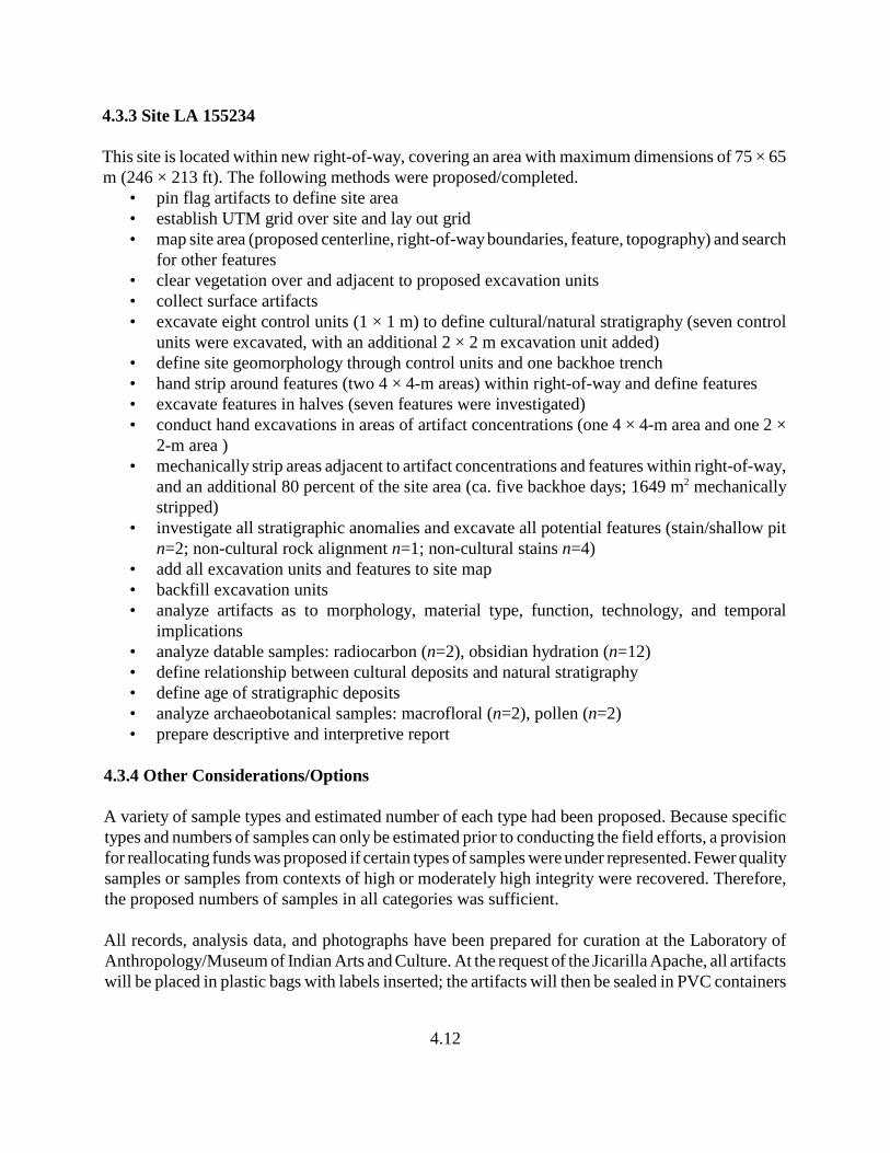
4.12
4.3.3 Site LA 155234
This site is located within new right-of-way, covering an area with maximum dimensions of 75 × 65m (246 × 213 ft). The following methods were proposed/completed.
• pin flag artifacts to define site area• establish UTM grid over site and lay out grid• map site area (proposed centerline, right-of-way boundaries, feature, topography) and search
for other features• clear vegetation over and adjacent to proposed excavation units• collect surface artifacts• excavate eight control units (1 × 1 m) to define cultural/natural stratigraphy (seven control
units were excavated, with an additional 2 × 2 m excavation unit added)• define site geomorphology through control units and one backhoe trench• hand strip around features (two 4 × 4-m areas) within right-of-way and define features• excavate features in halves (seven features were investigated)• conduct hand excavations in areas of artifact concentrations (one 4 × 4-m area and one 2 ×
2-m area )• mechanically strip areas adjacent to artifact concentrations and features within right-of-way,
and an additional 80 percent of the site area (ca. five backhoe days; 1649 m mechanically2
stripped)• investigate all stratigraphic anomalies and excavate all potential features (stain/shallow pit
n=2; non-cultural rock alignment n=1; non-cultural stains n=4)• add all excavation units and features to site map• backfill excavation units• analyze artifacts as to morphology, material type, function, technology, and temporal
implications• analyze datable samples: radiocarbon (n=2), obsidian hydration (n=12)• define relationship between cultural deposits and natural stratigraphy• define age of stratigraphic deposits• analyze archaeobotanical samples: macrofloral (n=2), pollen (n=2)• prepare descriptive and interpretive report
4.3.4 Other Considerations/Options
A variety of sample types and estimated number of each type had been proposed. Because specifictypes and numbers of samples can only be estimated prior to conducting the field efforts, a provisionfor reallocating funds was proposed if certain types of samples were under represented. Fewer qualitysamples or samples from contexts of high or moderately high integrity were recovered. Therefore,the proposed numbers of samples in all categories was sufficient.
All records, analysis data, and photographs have been prepared for curation at the Laboratory ofAnthropology/Museum of Indian Arts and Culture. At the request of the Jicarilla Apache, all artifactswill be placed in plastic bags with labels inserted; the artifacts will then be sealed in PVC containers

4.13
and reburied within the NMDOT right-of-way. The location of the buried artifacts will be recordedand curated at NMDOT in Santa Fe, and assigned an LA site number with the information alsomaintained within the ARMS database.
5.1
5.0 ARCHAEOLOGICAL DATA RECOVERY ATSITES LA 133205, LA 133206, and LA 155234
by Lindsay R. Poitevint and David H. Greenwald
5.1 Site LA 133205
Marshall (2001:31-34) described this site (located along the south side of US 64; Figure 5.1) as a“prehistoric encampment” consisting of a lithic artifact scatter with a “hearth” and assigned it to theArchaic period, San Rafael phase (ca. 3500–1800 B.C. [Middle-to-Late Archaic]). He described athermal feature exposed at the top of the road cut within the US 64 right-of-way. Also above the roadcut, he reported a one-hand mano, a burned bone, and 27 chipped stone artifacts within the highwayright-of-way. Marshall (2001) suggested that the site may yield important information about SanRafael phase land use in the Amargo drainage area, and considered the thermal feature to have thepotential to produce chronological data and information on archaeobotanical remains and strategiesused by Archaic period groups. When EMI revisited the site, Kuru’es et al. (2007) reported that thesite exhibited the same condition and composition as previously reported by Marshall (2001). Basedon Marshall’s (2001) description and a visit to the site, surface expressions and the exposed portionof the site in the road cut suggest that the site was used at least on a limited basis. Based on theexposed stain, time spent at the site was considered to have been of sufficient duration for occupantsto have constructed a sizeable thermal feature, presumably for food preparation. Food-processingactivities at this site are represented by a grinding implement and burned bone, and hunting bybifacially produced tools. Based on the site’s surface expressions, reconstruction of temporalassociations was considered highly feasible through recovery of anticipated charred organic remains;it was also anticipated that the charred organic remains may yield additional and more specificinformation about the range of economic resources procured and processed at the site.
5.1.1 Field Procedures
Field procedures for Site LA 133205 were restricted to the south side of US 64 within the right-of-way. Upon arriving at the site, the site area was defined by flagging tape and a UTM grid wasestablished over the site. Next, the crew pin flagged artifacts within the site area, and surface artifactswere collected.
Controlled surface collection was accomplished using a grid system with artifacts collectedaccording to 1 × 1-m units or by their point provenience. Before excavation began, vegetation wascleared over and adjacent to proposed control units and feature locations. Three control units (CU)were proposed in the data recovery plan. These control units (1 × 1-m) were placed in areas withhigh artifact density, near features, and/or in areas of possible stratigraphically deep cultural deposits.Each control unit was excavated in arbitrary (10 cm) levels, each level recorded on an FCRExcavation Unit Form, and profiles were drawn to scale.
}}}}
}}}}
}}}}
}}}}
}}}}
}}}}
}}}}
}}}}
}}}}
}}}}
}}}}
}}}}
}}}}
}}}}
}}}}
}}}}
}}}}
}}}}
}}}}
}}}}
}}}}
}}}}
}}}}
}}}}
E E
#*
#
#*
#*
#*
#*
E
F1F2F3 380N/35E380N/10E
375N/40E: Main mapping datum
4
5
1
2
3
Highway 64
2
1
3
LA 133205Feature Shapes
Test Unit Line
# Existing Site Datum
#* FCR Subdatum
E FCR Site Grid Coordinate
Control Units
Feature Excavations
Extent of Mechanical Stripping
Feature Bisection Line
Top of Slope Cut
Base of Bar Ditch
}} }} Fenceline
Highway 64 edge of pavement
380N Baseline
Map generated June 20, 2008Projection: UTM Datum: NAD 27
Zone: 13 N Units: Meters
0 5 102.5
Meters
±
Figure 5.1. Plan map of Site LA 133205 (Kuru'es, et al. 2007:64).
5.2
370N
375N
380N
385N
390N
015E 020E 025E 030E 035E 040E
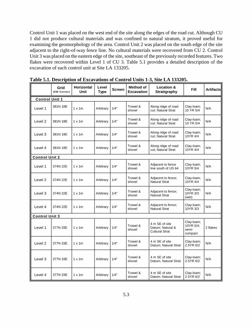
5.3
Control Unit 1 was placed on the west end of the site along the edges of the road cut. Although CU1 did not produce cultural materials and was confined to natural stratum, it proved useful forexamining the geomorphology of the area. Control Unit 2 was placed on the south edge of the siteadjacent to the right-of-way fence line. No cultural materials were recovered from CU 2. ControlUnit 3 was placed on the eastern edge of the site, southeast of the previously recorded features. Twoflakes were recovered within Level 1 of CU 3. Table 5.1 provides a detailed description of theexcavation of each control unit at Site LA 133205.
Table 5.1. Description of Excavations of Control Units 1-3, Site LA 133205.
Grid (SW Corner)
HorizontalUnit
LevelType
ScreenMethod ofExcavation
Location &Stratigraphy
Fill Artifacts
Control Unit 1
Level 1381N 18E
1 x 1m Arbitrary 1/4"Trowel &shovel
Along ridge of roadcut; Natural Strat
Clay-loam;10 YR 5/4
N/A
Level 2 381N 18E 1 x 1m Arbitrary 1/4"Trowel &shovel
Along ridge of roadcut; Natural Strat
Clay-loam;10 YR 5/4
N/A
Level 3 381N 18E 1 x 1m Arbitrary 1/4" Trowel &shovel
Along ridge of roadcut; Natural Strat
Clay-loam;10YR 4/4
N/A
Level 4 381N 18E 1 x 1m Arbitrary 1/4"Trowel &shovel
Along ridge of roadcut; Natural Strat
Clay-loam;10YR 4/4
N/A
Control Unit 2
Level 1 374N 22E 1 x 1m Arbitrary 1/4"Trowel &shovel
Adjacent to fenceline south of US 64
Clay-loam;10YR 5/4
N/A
Level 2 374N 22E 1 x 1m Arbitrary 1/4"Trowel &shovel
Adjacent to fence;Natural Strat
Clay-loam;10YR 4/4
N/A
Level 3 374N 22E 1 x 1m Arbitrary 1/4"Trowel &shovel
Adjacent to fence;Natural Strat
Clay-loam;10YR 3/3(wet)
N/A
Level 4 374N 22E 1 x 1m Arbitrary 1/4" Trowel &shovel
Adjacent to fence;Natural Strat
Clay-loam;10YR 3/3
N/A
Control Unit 3
Level 1 377N 33E 1 x 1m Arbitrary 1/4" Trowel &shovel
4 m SE of siteDatum; Natural &Cultural Strat
Clay-loam;10YR 5/4;semi-compact
2 flakes
Level 2 377N 33E 1 x 1m Arbitrary 1/4"Trowel &shovel
4 m SE of siteDatum; Natural Strat
Clay-loam;2.5YR 6/2
N/A
Level 3 377N 33E 1 x 1m Arbitrary 1/4"Trowel &shovel
4 m SE of siteDatum; Natural Strat
Clay-loam;2.5YR 6/2
N/A
Level 4 377N 33E 1 x 1m Arbitrary 1/4" Trowel &shovel
4 m SE of siteDatum; Natural Strat
Clay-loam;2.5YR 6/2
N/A

5.4
Prior to excavating the previously recorded feature (Marshall 2001), a 4 × 4-m hand stripping unit(HSU) was placed at the edge of the road cut over the feature to define the horizontal extent of eachfeature. The HSU uncovered two additional small stains and several artifacts, including historicglass, modern glass and metal, bone and several pieces of flaked stone. Four features were excavatedand recorded at Site LA 133205. The boundaries of each feature were defined and half of eachfeature was excavated to define the vertical stratum and to identify whether the feature was culturalversus natural. After the features were exposed, they were photographed in plan view. Each featurewas cross-sectioned, removing approximately half of the fill in order to prepare a view of theprofiles, which were drawn, and each stratigraphic unit was described using soil taxonomicnomenclature and a Munsell Soil Color chart to characterize the sediments. Once excavation of eachfeature was completed, a plan view and cross-section drawing were prepared. If a feature wasdiscovered to be non-cultural, the profile was not drawn and samples were not collected.
5.1.2 Feature Descriptions
Feature 1: Grid Provenience: 378N, 30E (SW corner)Vertical Provenience: 0.70-0.75 mbdFeature Type: Small Stain and associated shallow pit
Feature 1 was located on the south side of US 64 at the top of the road cut. It was a small stain thatmeasured 60 cm (24 inches) north-south by 40 cm (16 inches) east-west, and extended 5 cm (2inches) below datum. The feature was bisected to determine whether it was cultural versus naturaland to identify any subsurface cultural materials. The fill consisted of clay-loam sediments with ash,coal, and charcoal flecks. Radiocarbon, macrobotanical, and pollen samples were collected. Thefunction of Feature 1 is not known; although the feature originated on the surface as charred stain,no signs of burning or oxidation were present within the pit, preventing a specific function frombeing assigned to this feature.
Feature 2: Grid Provenience: 378N, 28E (SW corner)Vertical Provenience: 0.62-0.65 mbdFeature Type: Small Stain (non-cultural)
Feature 2 was located along the edge of the road cut on the south right-of-way of US 64. It was asmall surface ash stain that measured 25 cm (10 inches) north-south by 20 cm (8 inches) east-west,with 3 cm of stained sediments. Upon excavation it was apparent that the feature was a root burn andlacked cultural deposits. The fill consisted of loose, dark brown clay-loam and pieces of burned root.Feature 2 was determined to be of non-cultural origin.
Feature 3: Grid Provenience: 378N, 28E (SW corner)Vertical Provenience: 0.65-0.73 mbd Feature Type: Small Stain
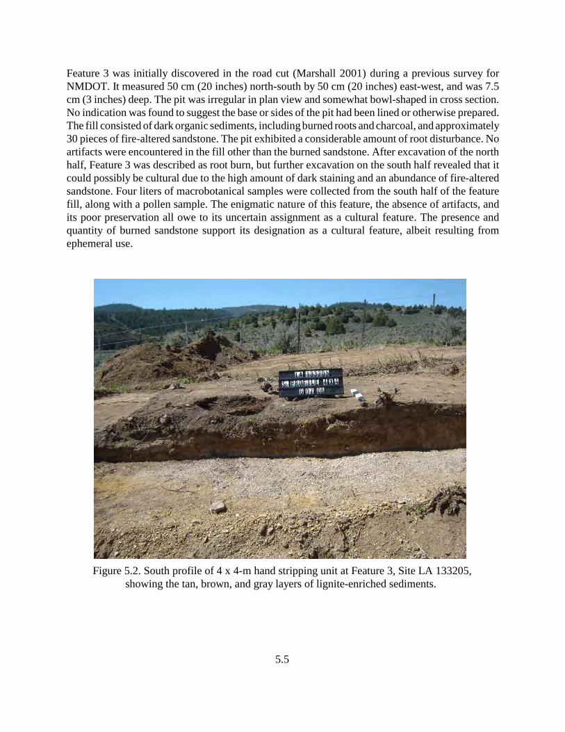
5.5
Feature 3 was initially discovered in the road cut (Marshall 2001) during a previous survey forNMDOT. It measured 50 cm (20 inches) north-south by 50 cm (20 inches) east-west, and was 7.5cm (3 inches) deep. The pit was irregular in plan view and somewhat bowl-shaped in cross section.No indication was found to suggest the base or sides of the pit had been lined or otherwise prepared.The fill consisted of dark organic sediments, including burned roots and charcoal, and approximately30 pieces of fire-altered sandstone. The pit exhibited a considerable amount of root disturbance. Noartifacts were encountered in the fill other than the burned sandstone. After excavation of the northhalf, Feature 3 was described as root burn, but further excavation on the south half revealed that itcould possibly be cultural due to the high amount of dark staining and an abundance of fire-alteredsandstone. Four liters of macrobotanical samples were collected from the south half of the featurefill, along with a pollen sample. The enigmatic nature of this feature, the absence of artifacts, andits poor preservation all owe to its uncertain assignment as a cultural feature. The presence andquantity of burned sandstone support its designation as a cultural feature, albeit resulting fromephemeral use.
Figure 5.2. South profile of 4 x 4-m hand stripping unit at Feature 3, Site LA 133205,showing the tan, brown, and gray layers of lignite-enriched sediments.
5.6
Feature 4: Grid Provenience: 373N, 26E (SW corner)Vertical Provenience: 0.13-0.18 mbdFeature Type: Small Stain (non-cultural)
Feature 4 was discovered in the mechanical stripping unit within the south right-of-way of US 64adjacent to the fence line. On the surface, the feature was a circular dark stain measuring 25 cm (10inches) north-south by 20 cm (8 inches) east-west, and was 5 cm (2 inches) thick. The feature wasbisected and the south half was excavated. The fill consisted of compacted clay-loam sediments withburned sage brush roots. For this reason, Feature 4 was determined to be non-cultural in origin.
After all stripping and excavations were complete, the site was mapped with a total station. The sitearea, including the roadway, right-of-way boundaries, fence lines, features, all excavation units(control units, hand stripping units, and mechanical stripping units), cut banks, and bar-ditches weremapped. The entire site area within the right-of-way (ca. 10 × 25-m area [33 × 82 ft]) wasmechanically stripped. Within the stripped area near the fence line, one feature was exposed andexcavated (Feature 4).
In addition, Steve Hall, project geomorphologist, visited the site to evaluate all stratigraphy andassess the relationship between cultural deposits and natural stratigraphy (see Chapter 9). He alsoprovided a geological history of the site area and aided field personnel with stratigraphic/culturaldeposition relationship.
5.1.3 Material Culture
5.1.3.1 Flaked Stone
A total of 21 flaked stone artifacts were recovered and analyzed from Site LA 133205. Theassemblage includes 19 pieces of debitage, 1 utilized flake, and 1 biface. The material types utilizedwere obtained from local sources, which include chalcedony, chert, and quartzite, and from nonlocalsources from north-central and northwestern New Mexico, which include obsidian and possiblychert. The only formal tool, one biface, was produced of obsidian, probably from Jemez Mountaingeological formation obsidian. The 19 pieces of debitage represent platform-bearing flakes and flakefragments, suggesting tool manufacturing activities were conducted at the site. The lack of cores andcortex suggests flake production and early-stage tool production occurred elsewhere, a characteristicof highly mobile groups.
5.1.3.2 Ground Stone
Four ground stone items were recovered from Site LA 133205, all from surface contexts. Theassemblage includes two mano fragments and two netherstone fragments. Materials used werealluvial cobbles of felsic igneous, sandstone, and fine-grained sandstone. One mano exhibitedpecking and polishing on the entire surface area. The other mano was a small fragment of sandstone,with utilization on opposing surfaces. The netherstone fragments were slabs of fine-grained
5.7
sandstone. One specimen was unifacially pecked; the other had two opposing use surfaces and hadbeen roughened by pecking.
5.1.4 Subsistence Remains
5.1.4.1 Macrobotanical and Pollen Remains
The two pollen and two macrofloral samples analyzed from this site provide few insights into theexploitation of native plant resources by prehistoric groups. However, three taxa were recognizedas possible economic resources: goosefoot and amaranth (represented by 10 whole and threefragmentary charred seeds); grasses that produced small seeds (uncharred); and members of themustard family.
5.1.4.2 Faunal Remains
The 22 faunal remains from Site LA 133205 were collected from screened contexts in Levels 1 and2 of cultural-bearing deposits. The 22 fragments represent 17 specimens, ranging from smallmammal (i.e., cottontail) to large mammal, including Bos/bison-size and Artiodactyla-size animals.All bones recovered from the site represent typical dietary faunal remains.
One specimen from a cottontail rabbit was recovered from Level 1 of Feature 3; although thisfragment did not display evidence of cut marks or burning, its occurrence in a feature suggests it mayhave been used for subsistence. The remaining bone fragments were recovered from Level 2contexts, including medium-to-large mammal bone fragments of various elements. Two of the largemammal fragments exhibited evidence of gnawing. The majority of bones were weathered, resultingin poorly preserved and minimally intact external surfaces. Although these elements did not displaysigns of burning, they were likely utilized to meet subsistence needs.
5.1.5 Chronology
5.1.5.1 Stratigraphy
The cultural remains at Site LA 133205 were situated at the top of a road cut on a low, sagebrush-covered ridge south of US 64. The natural stratigraphy of the site is described (see Chapter 9) asbeing formed by Cretaceous shale, with some local lignite. Evidence from the features and controlunits suggest the sediment cover overlying the weathered bedrock is very thin. The colluviumthroughout the site is light-brown fine silty sand, with small inclusions of sandstone pebbles; Hall(this report) suggests the colluvium is of Late Holocene age. Because soil formation has not occurred,Hall suggests the colluvium is of recent age (see Chapter 9). Cultural features of the site occur in thecolluvial deposits as well as directly on the weathered Cretaceous bedrock.
5.8
5.1.5.2 Absolute Dates
A single radiocarbon sample (No. 26) was submitted from Site LA 133205 to Beta Analytic forstandard AMS dating (see Appendix B for full presentation of Measured Radiocarbon Age, 13C/12CRatio, Conventional Radiocarbon Age, and 2 Sigma Calibrations). Three possible date ranges werecalculated at 2 Sigma (95 percent probability) (810–750 B.C.; 690–660 B.C.; and 640–590 B.C.), allfalling within the Late Archaic period. The intercept date, which was calculated at 1 Sigma (68percent probability), falls at 800–760 B.C., or at 780 B.C. on the calibration curve. The limited lithicassemblage, absence of formal, diagnostic tools, and lack of other radiocarbon or other dateablesamples precludes this site from being further evaluated in terms of its age. The stratigraphicimplications suggest that the area was not subject to the development of soil, but has remainedlargely unchanged since the colluvium was deposited. Hall’s suggested “Late Holocene” age for thecolluvium and the presence of cultural deposits that date less than 3000 years in age do not seem tocontradict one another (see Chapter 9), although one would expect more progressive developmentof Holocene soils on top of the colluvium unless the area was subject to geologic degradation.
5.1.6 Summary of Field and Analytical Interpretations
The site has been impacted and disturbed from the previous construction of US 64, primarily the roadcut on the south side of the site and the drainage ditch positioned at the top of the slope cut. A fenceline more or less bisects the site east-west, and the site continues south onto private land. Otherdisturbances included rodent bioturbation that was seen within the control units, at least one buriedfiber optic line, and surface blading associated with the fiber optic line.
Site LA 133205 represents an ephemeral camp used by groups during the Late Archaic period. Thetwo features considered cultural in origin support limited use; artifacts from features were limitedto burned sandstone and the entire site assemblage was meager. The temporal range of the site issuggested through radiocarbon dating between approximately 810 B.C. and 590 B.C. (Appendix B).Although diagnostic artifacts were not recovered during the data recovery efforts, Marshall (2001:34)reported finding a San Rafael/Sudden Side-notched point base south of the highway right-of-way.Points of this type have a wide temporal range, dating between approximately 3500 B.C. and A.D. 200.The radiocarbon date range received for this site agrees with the temporal range of the projectilepoint.
5.2 Site LA 133206
This site (located on both sides of US 64; Figure 5.3) was described by Marshall (2001:34-37) as a“multi-component” prehistoric lithic artifact scatter (with two spatially associated hearths), a historicartifact scatter, and a modern corral. He suggested the lithic artifact scatter is affiliated with theArchaic period, and the historic artifacts represent an Anglo/Hispanic camp that dates between about1880 and 1910. Prior to initiating the data-recovery efforts at this site, it was noted that the historicartifact scatter was present on both sides of the highway, with the densest concentration of materialslocated in the north right-of-way, an observation also made by Marshall. In addition to the two
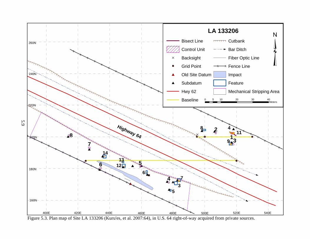
< Dou
ble-cl
ick to
enter
map
title
>X
XX
XX
XX
XX
XX
XX
XX
XX
XX
XX
XX
XX
XX
XX
X
XX
XX
XX
XX
XX
XX
XX
XX
XX
XX
XX
XX
#I
#I
#I#I #I
#I
#I
#I
#I#I
#I#I
#I
#I
#I
#I
#I
D
D
Highway 64
1413
12
119
76
488
71
6 5
3
4
2
LA 133206Bisect Line
Control Unit
D Backsight
Grid Point
#I Old Site Datum
#I Subdatum
Hwy 62
Baseline
Cutbank
Bar Ditch
Fiber Optic Line
X X Fence Line
Impact
Feature
Mechanical Stripping Area
³0 10 20 30 405
Meters
Figure 5.3. Plan map of Site LA 133206 (Kuru'es, et al. 2007:64), in U.S. 64 right-of-way acquired from private sources.
5.9
35
160N
180N
200N
220N
240N
260N
400E 420E 440E 460E 480E 500E 520E 540E

5.10
thermal features (stained areas at the top of the road cut) first recognized by Marshall, a third stainwas observed near the eastern edge of the site within the south right-of-way of US 64 above the roadcut. Historic artifacts, including sun-colored amethyst (SCA) and aqua glass, were noted in proximityof the easternmost hearth stain, suggesting contemporaneity may exist between the artifact scatterand this thermal feature. During a visit to the site by EMI, Kuru’es et al. (2007:25) discovered afourth feature located south of the south right-of-way fence, beyond the area of proposedinvestigations (Figure 5.3). Described as a “concentration of rubble,” this fourth feature “contains20 sandstone cobbles in a 4 m diameter area,” with nearby historic artifacts (Kuru’es et al. 2007:25).Although the EMI report indicates that “the original configuration and function of the feature isunknown,” a visit to this feature during the current project (with approval of Blake Roxlau andpermission from the land owner) indicated that the area of rubble extends over a much larger area,with a greater number of sandstone pieces present and an extensive artifact scatter. The feature mayrepresent the remains of a stone foundation to one or more historic-era structures, perhaps ofAnglo/Hispanic affiliation. No investigations were proposed for the rubble feature other than toevaluate it on the basis of its surface expressions, as it lies beyond the right-of-way and area ofproposed investigations. Based on Marshall’s description, and a re-evaluation during a pre-excavation site visit, surface expressions and the exposed portion of the site in the road cut suggestthat the site was used for a sufficient duration by occupants to have possibly constructed severalthermal features, presumably for food preparation. Food-processing activities are represented bynumerous pieces of grinding implements, some exhibiting burning. These thermal features mayrepresent food preparation activities and related short-term habitation activities. The structuralremains beyond the right-of-way suggest increased permanence and use of the site by historic-periodgroups. Reconstruction of temporal associations was considered a high priority of the project at thissite, based on charred organic remains, which were also considered to have the potential to yieldadditional and more specific information about other economic resources procured and processedat the site. Investigations of the features and adjacent areas were also anticipated to generatetemporally sensitive artifacts.
5.2.1 Field Procedures
Field procedures for Site LA 133206 involved excavations on both sides of US 64 within the right-of-way. Upon arriving at the site, the site area was defined by flagging tape and a UTM grid wasestablished over the portion of the site within the right-of-way. Next, the crew pin flagged artifactswithin the site area, and surface artifacts were collected by recording them on an FCR bag list, andcollecting them in paper bags labeled with corresponding provenience information. Beforeexcavation began, vegetation was cleared over and adjacent to proposed control units and features.
Eight control units were proposed in the data recovery plan. These 1 × 1-m control units were placedin areas with high artifact density, near features and/or in areas of stratigraphic deposits with highintegrity. Each control unit was excavated in arbitrary (10 cm) levels, each level recorded on an FCRExcavation Unit Form, and profiles were drawn to scale. Control Units 1 through 3 were placed onthe north side of US 64; Control Unit 1 was placed over the southeast quarter of Feature 4; ControlUnit 2 was placed to the west on a low rise; with Control Unit 3 directly south of Control Unit 1 nearthe edge of the road cut.
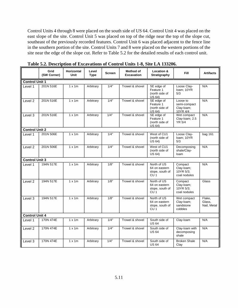
5.11
Control Units 4 through 8 were placed on the south side of US 64. Control Unit 4 was placed on theeast slope of the site. Control Unit 5 was placed on top of the ridge near the top of the slope cut,southeast of the previously recorded features. Control Unit 6 was placed adjacent to the fence linein the southern portion of the site. Control Units 7 and 8 were placed on the western portions of thesite near the edge of the slope cut. Refer to Table 5.2 for the detailed results of each control unit.
Table 5.2. Description of Excavations of Control Units 1-8, Site LA 133206.
Grid(SW Corner)
HorizontalUnit
LevelType
ScreenMethod ofExcavation
Location &Stratigraphy
Fill Artifacts
Control Unit 1
Level 1 201N 516E 1 x 1m Arbitrary 1/4" Trowel & shovel SE edge ofFeature 1(north side ofUS 64)
Loose Clay-loam; 10YR5/3
N/A
Level 2 201N 516E 1 x 1m Arbitrary 1/4" Trowel & shovel SE edge ofFeature 1(north side ofUS 64)
Loose tosemi-compactClay-loam;10YR 4/4
N/A
Level 3 201N 516E 1 x 1m Arbitrary 1/4" Trowel & shovel SE edge ofFeature 1(north side ofUS 64)
Wet compactClay-loam; 2.5YR 5/4
N/A
Control Unit 2
Level 1 201N 506E 1 x 1m Arbitrary 1/4" Trowel & shovel West of CU1(north side ofUS 64)
Loose Clay-loam; 10YR5/3
bag 161
Level 2 201N 506E 1 x 1m Arbitrary 1/4" Trowel & shovel West of CU1(north side ofUS 64)
Decomposingshale/Clay-loam
N/A
Control Unit 3
Level 1 194N 517E 1 x 1m Arbitrary 1/8" Trowel & shovel North of US64 on easternslope, south ofCU 1
CompactClay-loam;10YR 5/3;coal nodules
N/A
Level 2 194N 517E 1 x 1m Arbitrary 1/8" Trowel & shovel North of US64 on easternslope, south ofCU 1
CompactClay-loam;10YR 5/3;coal nodules
Glass
Level 3 194N 517E 1 x 1m Arbitrary 1/8" Trowel & shovel North of US64 on easternslope, south ofCU 1
Wet compactClay-loam;sandstonecobbles
Flake,Glass,Nail, Metal
Control Unit 4
Level 1 170N 474E 1 x 1m Arbitrary 1/4" Trowel & shovel South side ofUS 64
Clay-loam N/A
Level 2 170N 474E 1 x 1m Arbitrary 1/4" Trowel & shovel South side ofUS 64
Clay-loam withdecomposingshale
N/A
Level 3 170N 474E 1 x 1m Arbitrary 1/4" Trowel & shovel South side ofUS 64
Broken ShaleClay
N/A

Table 5.2. Description of Excavations of Control Units 1-8, Site LA 133206, continued.
Grid(SW Corner)
HorizontalUnit
LevelType
ScreenMethod ofExcavation
Location &Stratigraphy
Fill Artifacts
5.12
Level 4 170N 474E 1 x 1m Arbitrary 1/4" Trowel & shovel South side ofUS 64
Plated ShaleClay over solidLimestone
N/A
Control Unit 5Level 1 180N 459E 1 x 1m Arbitrary 1/4" Trowel & shovel South of US
64 along ridgeline
Loose topsoil;10YR 5/3
N/A
Level 2 180N 459E 1 x 1m Arbitrary 1/4" Trowel & shovel South of US64 along ridgeline
Clay-loam;disturbed fill;charcoalflecking
Glass
Level 3 180N 459E 1 x 1m Arbitrary 1/4" Trowel & shovel South of US64 along ridgeline
Dark Clay-loam with redsandstone
N/A
Control Unit 6Level 1 179N 434E 1 x 1m Arbitrary 1/4" Trowel & shovel Near ROW
fence, south ofUS 64
Loose siltyloam; 10YR5/3
N/A
Level 2 179N 434E 1 x 1m Arbitrary 1/4" Trowel & shovel Near ROWfence, south ofUS 64
Loose siltyClay-loam;10YR 5/3
Glass,Metal
Level 3 179N 434E 1 x 1m Arbitrary 1/4" Trowel & shovel Near ROWfence, south ofUS 64
Semi-looseClay-loam;10YR 5/3
FlakedStone
Level 4 179N 434E 1 x 1m Arbitrary 1/4" Trowel & shovel Near ROWfence, south ofUS 64
Semi-looseClay-loam;10YR 5/3
N/A
Control Unit 7Level 1 192N 427E 1 x 1m Arbitrary 1/4" Trowel & shovel South of US
64 Clay-loam Nail
Level 2 192N 427E 1 x 1m Arbitrary 1/4" Trowel & shovel South of US64
Clay-loam N/A
Level 3 192N 427E 1 x 1m Arbitrary 1/4" Trowel & shovel South of US64
Clay-loam toshale
N/A
Control Unit 8Level 1 200N 414E 1 x 1m Arbitrary 1/4" Trowel & shovel South side of
US 64;towards NWpart of site
Loose Clay-loam
2 Nails
Level 2 200N 414E 1 x 1m Arbitrary 1/4" Trowel & shovel South side ofUS 64;towards NWpart of site
Moderatelycompact Clay-loam withsmall rocks
Nails, Pin,and Glass
Level 3 200N 414E 1 x 1m Arbitrary 1/4" Trowel & shovel South side ofUS 64;towards NWpart of site
Rich, looseloam topsoil
N/A
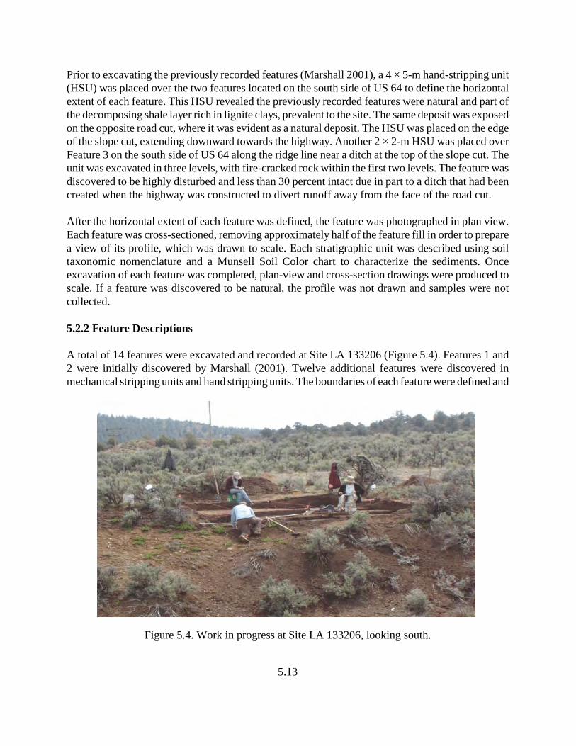
5.13
Prior to excavating the previously recorded features (Marshall 2001), a 4 × 5-m hand-stripping unit(HSU) was placed over the two features located on the south side of US 64 to define the horizontalextent of each feature. This HSU revealed the previously recorded features were natural and part ofthe decomposing shale layer rich in lignite clays, prevalent to the site. The same deposit was exposedon the opposite road cut, where it was evident as a natural deposit. The HSU was placed on the edgeof the slope cut, extending downward towards the highway. Another 2 × 2-m HSU was placed overFeature 3 on the south side of US 64 along the ridge line near a ditch at the top of the slope cut. Theunit was excavated in three levels, with fire-cracked rock within the first two levels. The feature wasdiscovered to be highly disturbed and less than 30 percent intact due in part to a ditch that had beencreated when the highway was constructed to divert runoff away from the face of the road cut.
After the horizontal extent of each feature was defined, the feature was photographed in plan view.Each feature was cross-sectioned, removing approximately half of the feature fill in order to preparea view of its profile, which was drawn to scale. Each stratigraphic unit was described using soiltaxonomic nomenclature and a Munsell Soil Color chart to characterize the sediments. Onceexcavation of each feature was completed, plan-view and cross-section drawings were produced toscale. If a feature was discovered to be natural, the profile was not drawn and samples were notcollected.
5.2.2 Feature Descriptions
A total of 14 features were excavated and recorded at Site LA 133206 (Figure 5.4). Features 1 and2 were initially discovered by Marshall (2001). Twelve additional features were discovered inmechanical stripping units and hand stripping units. The boundaries of each feature were defined and
Figure 5.4. Work in progress at Site LA 133206, looking south.
5.14
half of each feature was excavated to define the vertical strata, to determine its stratigraphicassociations with other cultural deposits, and to identify whether the feature was cultural or the resultof natural causes.
Feature 1: Grid Provenience: 181N, 455E (SW corner)Vertical Provenience: surficialFeature Type: Stain (non-cultural)
Feature 1 was initially discovered by Marshall (2001) and was associated with another stain on thesouth side of US 64 along the edge of the slope cut. A 4 × 5-m HSU was placed near and overFeature 1 in order to define the extent of the feature and to determine whether it possessed depth. Itwas determined through excavation efforts that Feature 1 was a dark organic decomposing shalestratum, rich in lignite, and of non-cultural origin. Once the 4 × 5-m unit had been excavated, thedark organic shale deposit became apparent. Across US 64 in the opposing road cut, the same shaledeposit is exposed and provides an example of the organic sediments easily confused as cultural,organic staining similar to a fire pit or other thermal feature.
Feature 2: Grid Provenience: 181N, 455E (SW corner)Vertical Provenience: SurficialFeature Type: Stain (non-cultural)
Feature 2 was initially discovered by Marshall (2001) and was described as a hearth spatiallyassociated with another hearth (Feature 1). Feature 2 was located at the top of the slope on the southside of US 64 and exposed in the slope cut. A 4 × 5-m HSU was placed over the feature to define theextent of the feature’s edges and to determine whether the feature had depth. It was determined thatFeature 2 is part of a dark organic decomposing shale stratum, rich in lignite, and of non-culturalorigin. This feature, as with Feature 1, is part of the natural dark shale deposit containing ligniteenriched clay derived from decomposing shale and easily confused as cultural, organic stainingsimilar to a fire pit or other thermal feature.
Feature 3: Grid Provenience: 169N, 481E (SW corner)Vertical Provenience: SurficialFeature Type: FCR/Stain
Feature 3 was a fire-cracked rock (FCR) concentration with surface staining located south of US 64on the east edge of the site and approximately 2 m south of the edge of the slope cut. A 2 × 2-m HSUwas placed over the feature to define the extent of the feature and to determine if the featurepossessed depth. The majority of FCR was located on the surface with three pieces recovered fromsubsurface deposits. While excavating the 2 × 2-m unit, no stain or distinct edges were apparent.Feature 3 was highly eroded, and no other cultural materials were associated with it.
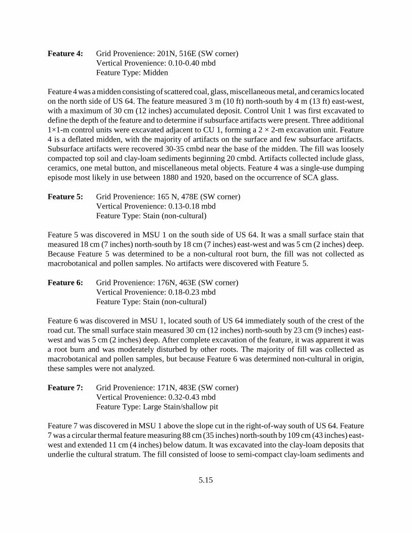
5.15
Feature 4: Grid Provenience: 201N, 516E (SW corner)Vertical Provenience: 0.10-0.40 mbdFeature Type: Midden
Feature 4 was a midden consisting of scattered coal, glass, miscellaneous metal, and ceramics locatedon the north side of US 64. The feature measured 3 m (10 ft) north-south by 4 m (13 ft) east-west,with a maximum of 30 cm (12 inches) accumulated deposit. Control Unit 1 was first excavated todefine the depth of the feature and to determine if subsurface artifacts were present. Three additional1×1-m control units were excavated adjacent to CU 1, forming a 2 × 2-m excavation unit. Feature4 is a deflated midden, with the majority of artifacts on the surface and few subsurface artifacts.Subsurface artifacts were recovered 30-35 cmbd near the base of the midden. The fill was looselycompacted top soil and clay-loam sediments beginning 20 cmbd. Artifacts collected include glass,ceramics, one metal button, and miscellaneous metal objects. Feature 4 was a single-use dumpingepisode most likely in use between 1880 and 1920, based on the occurrence of SCA glass.
Feature 5: Grid Provenience: 165 N, 478E (SW corner)Vertical Provenience: 0.13-0.18 mbdFeature Type: Stain (non-cultural)
Feature 5 was discovered in MSU 1 on the south side of US 64. It was a small surface stain thatmeasured 18 cm (7 inches) north-south by 18 cm (7 inches) east-west and was 5 cm (2 inches) deep.Because Feature 5 was determined to be a non-cultural root burn, the fill was not collected asmacrobotanical and pollen samples. No artifacts were discovered with Feature 5.
Feature 6: Grid Provenience: 176N, 463E (SW corner)Vertical Provenience: 0.18-0.23 mbdFeature Type: Stain (non-cultural)
Feature 6 was discovered in MSU 1, located south of US 64 immediately south of the crest of theroad cut. The small surface stain measured 30 cm (12 inches) north-south by 23 cm (9 inches) east-west and was 5 cm (2 inches) deep. After complete excavation of the feature, it was apparent it wasa root burn and was moderately disturbed by other roots. The majority of fill was collected asmacrobotanical and pollen samples, but because Feature 6 was determined non-cultural in origin,these samples were not analyzed.
Feature 7: Grid Provenience: 171N, 483E (SW corner)Vertical Provenience: 0.32-0.43 mbdFeature Type: Large Stain/shallow pit
Feature 7 was discovered in MSU 1 above the slope cut in the right-of-way south of US 64. Feature7 was a circular thermal feature measuring 88 cm (35 inches) north-south by 109 cm (43 inches) east-west and extended 11 cm (4 inches) below datum. It was excavated into the clay-loam deposits thatunderlie the cultural stratum. The fill consisted of loose to semi-compact clay-loam sediments and
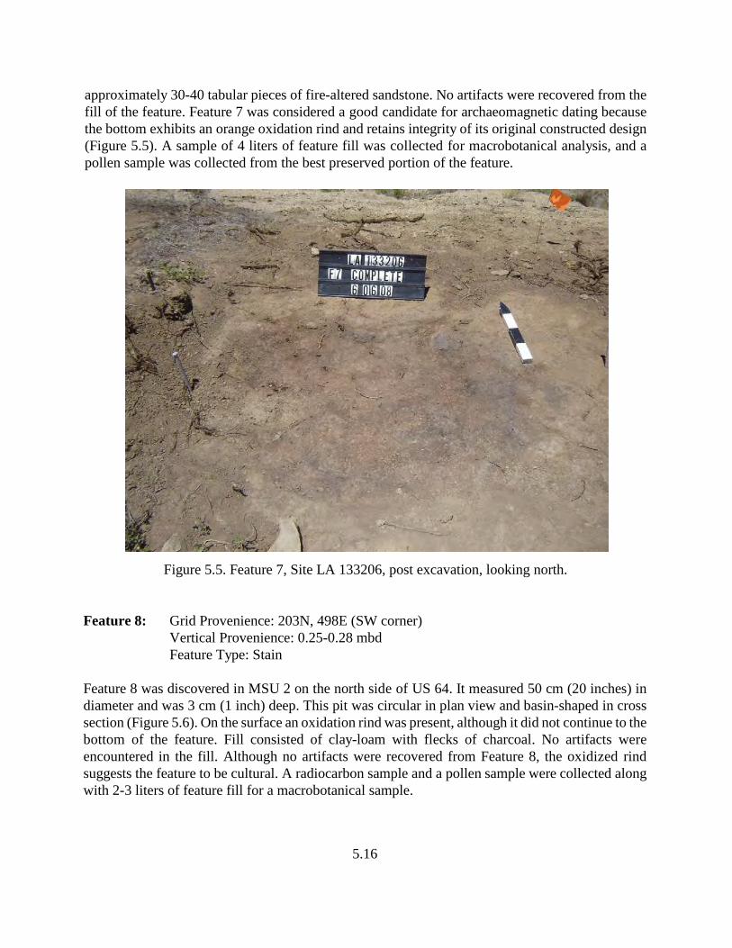
5.16
approximately 30-40 tabular pieces of fire-altered sandstone. No artifacts were recovered from thefill of the feature. Feature 7 was considered a good candidate for archaeomagnetic dating becausethe bottom exhibits an orange oxidation rind and retains integrity of its original constructed design(Figure 5.5). A sample of 4 liters of feature fill was collected for macrobotanical analysis, and apollen sample was collected from the best preserved portion of the feature.
Figure 5.5. Feature 7, Site LA 133206, post excavation, looking north.
Feature 8: Grid Provenience: 203N, 498E (SW corner)Vertical Provenience: 0.25-0.28 mbdFeature Type: Stain
Feature 8 was discovered in MSU 2 on the north side of US 64. It measured 50 cm (20 inches) indiameter and was 3 cm (1 inch) deep. This pit was circular in plan view and basin-shaped in crosssection (Figure 5.6). On the surface an oxidation rind was present, although it did not continue to thebottom of the feature. Fill consisted of clay-loam with flecks of charcoal. No artifacts wereencountered in the fill. Although no artifacts were recovered from Feature 8, the oxidized rindsuggests the feature to be cultural. A radiocarbon sample and a pollen sample were collected alongwith 2-3 liters of feature fill for a macrobotanical sample.
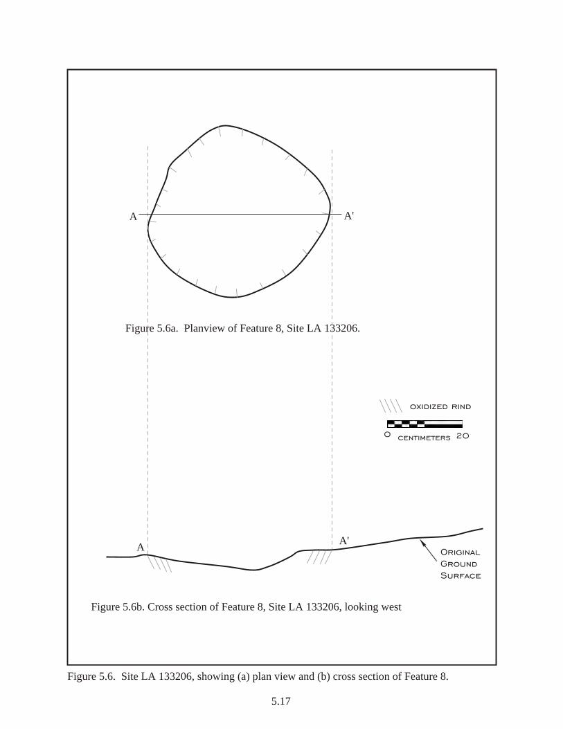
Figure 5.6a. Planview of Feature 8, Site LA 133206.
Figure 5.6b. Cross section of Feature 8, Site LA 133206, looking west
0 20centimeters
Original Ground Surface
Figure 5.6. Site LA 133206, showing (a) plan view and (b) cross section of Feature 8.
oxidized rind
AA'
A'A
5.17
5.18
Feature 9: Grid Provenience: 194N, 515E (SW corner)Vertical Provenience: 0.13-0.23 mbd
Feature Type: Rock concentration (non-cultural)
Feature 9 was discovered in MSU 2 on the north side of US 64 west of Control Unit 3. It was a smallconcentration of rocks, which measured 136 cm (53 inches) north-south by 100 cm (39 inches) east-west and concentrated at a depth of 10 cm (4 inches). The fill consisted of five or six sandstone andquartzite rocks in loose, clay-loam sediments located immediately below the surface. Feature 9 wasdetermined non-cultural due to its amorphous shape and a lack of subsurface cultural deposits.
Feature 10: Grid Provenience: 192N, 517E (SW corner)Vertical Provenience: 0.29-0.34 mbdFeature Type: Small Stain (non-cultural)
Feature 10 was discovered in MSU 2 located on the north right-of-way of US 64. The small stainmeasured 45 cm (18 inches) north-south by 26 cm (10 inches) east-west, extending 5 cm (2 inches)below datum. The feature was bisected to determine whether it was cultural or natural. Feature 10had an irregular shape in plan view and in cross section. Directly under the surface sediments andstained area was a metal can and several fragments of broken modern glass. Feature 10 wasdetermined to be of non-historic origins and may be the result of non-cultural activities.
Feature 11: Grid Provenience: 200N, 518E (SW corner)Vertical Provenience: 0.41-0.57 mbdFeature Type: Stain (non-cultural)
Feature 11 was discovered in MSU 2 on the north side of US 64, east of Control Unit 1 and Feature4. The surface stain measured 83 cm (33 inches) north-south by 20 cm (8 inches) east-west and was11 cm (4 inches) deep. The feature was bisected in order to define the shape of the cross-section andto determine whether it was cultural or natural. The fill consisted of compact clay and decomposingshale. No artifacts were discovered. Feature 11 was determined to be non-cultural in origin.
Feature 12: Grid Provenience: 180N, 448E (SW corner)Vertical Provenience: 0.19-0.28 mbdFeature Type: Stain (non-cultural)
Feature 12 was discovered in MSU 1, south of US 64, and immediately south of Feature 13. Thefeature was bisected to determine whether it was cultural or natural. The east side was excavated, butrevealed no distinct edges. The staining was discontinuous and was caused by a root burn. The fillconsisted of clay-loam sediments with coal and burned roots. Feature 12 was determined to be non-cultural.

5.19
Feature 13: Grid Provenience: 183N, 448E (SW corner)Vertical Provenience: 0.29-0.33 mbdFeature Type: Stain (non-cultural )
Feature 13 was discovered in MSU 1, located on the south side of US 64 directly north of Feature12. It measured 44 cm (17 inches) north-south by 50 cm (20 inches) east-west and was 4 cm (2inches) deep. The feature was first bisected to determine its vertical extent. The stain was amorphousin shape with no distinct edges. The second half was excavated and determined to be root burn. Alarge piece of burned material was collected for species identification, which was identified as pine.Although Feature 13 was determined non-cultural during the field efforts, the presence of the burnedpiece of pine probably represents its use at the site and the site may have cultural origins.
Feature 14: Grid Provenience: 186N, 431E (SW corner)Vertical Provenience: 0.12-0.19 mbdFeature Type: Stain (non-cultural)
Feature 14, discovered in MSU 1, was located on the south side of US 64 on the western portion ofthe site. It measured 65 cm (26 inches) east-west by 45 cm (18 inches) north-south and was 7 cm (3inches) deep. The majority of the stain was confined to the surface. The feature was bisected south-west by north-east and the north side was excavated. Feature 14 was amorphous in shape, wasdetermined to be caused by root burn, and was determined non-cultural.
The remainder of the site area on both sides of US 64 within the right-of-way was mechanicallystripped. Approximately 95-99 percent of the site was mechanically stripped. In addition, Steve Hall,project geomorphologist, visited the site to evaluate the stratigraphy of the site area and therelationship between the natural and cultural stratigraphy (refer to Chapter 9 for Hall’scharacterization of the site geomorphology).
The site area, including all road features and disturbances (e.g., roadway, right-of-way boundary,fence lines, features, cut bank, bar-ditches, all excavation units), was mapped using a total station.
5.2.3 Material Culture
5.2.3.1 Ceramics
A total of 27 historic ceramics were recovered from Site LA 133206. The historic ceramicassemblage includes hard-paste glazed whiteware and vitreous porcelain. The majority of ceramicswere recovered during the surface collection; one was recovered through excavation from Feature4. The assemblage was highly fragmented. Only two pieces retain a small portion of their maker’smark; however, none were identified as diagnostic. The ceramic assemblage provides few data fromwhich temporal associations, site function, or ethnicity can be addressed.
5.20
5.2.3.2 Metal
A total of 45 metal artifacts were recovered from Site LA 133206. The metal assemblage wasdominated by square nails and steel cans/can fragments. Other metal artifacts included miscellaneouspieces of metal, a railroad spike, a slot-end screwdriver, a corkscrew, a tablespoon, a modern wirenail, a safety pin/fastener, a button, and a round shovel blade. The metal artifacts were recoveredthrough surface collection efforts and from excavations (1 × 1 m control units and mechanicalscraping units). The pressed-copper pant button was recovered from Feature 4. The majority of metalartifacts were recovered on the north side of US 64. 5.2.3.3 Glass
A total of 201 glass artifacts were recovered from Site LA 133206. The glass assemblage wasdominated by amber/brown-colored glass, followed by clear/natural, sun-colored amethyst, aqua,olive, amethyst, and yellow. The glass assemblage represents several forms, including bottle,container, window, bowl/dish, and insulator. The majority of the glass assemblage was recoveredfrom surface collections; additional glass artifacts were recovered from excavation (control units,features, and mechanical scraping units).
Although there were no indications of a structure on the site, window glass was recovered fromvarious locations on the site. These glass artifacts may be associated with the structure/rubble thatlies south of the right-of-way, or another structure may have been in the existing highway alignmentsthat accounts for artifacts on the north side of US 64.
The variety of colored glass and thickness of glass fragments, specifically the amber glass fragments,suggests an extensive production period of bottles, both beverage and chemical containers. Thecolorless glass, including thin window pane glass, have open-ended dates from the 1830s to present.Based on the diagnostic glass artifacts, two possible occupation periods exist for Site LA 133206.The first occupation ranges from 1856 to approximately 1920. A second period of occupation isrepresented by the Depression glass, suggesting a date from the 1930s to the 1940s.
5.2.3.4 Flaked Stone
A total of 48 flaked stone artifacts were recovered from Site LA 133206. These included 39 piecesof flaked stone debitage, eight tools, and one core. The materials utilized were chert, an unspecifiedfelsic igneous material, obsidian, and chalcedony. Debitage was primarily composed of flakefragments and platform-bearing flakes. A core/hammerstone of felsic igneous material was recoveredfrom the site surface. The core had a single platform, retained cortex and exhibited heavy poundinguse wear on the ends. Of the eight tools recovered, three were bifaces; none were complete. Onebiface was made of tan heat-treated chert. One obsidian projectile point was recovered from thesurface. The point possesses side-notches, a straight base, but is asymmetrical in plan view due toreworking of the blade. The side-notching and slightly serrated edges suggest a Late Archaic periodassociation.
5.21
5.2.3.5 Ground Stone
A total of eight ground stone artifacts were recovered from Site LA 155234. These include two slabmetate fragments, five indeterminate netherstone fragments, and one possible mano blank, all of fine-grained sandstone material, except for the latter. The possible mano blank was a coarse-grained felsicigneous material. Pecking was present on the edges and ends, indicating the mano blank had beensubjected to some shaping effort; it was also oval in shape, similar to one-hand manos.
The slab metates were derived from fine-grained sandstone, and all were recovered from the surface.Both slab metates had grinding surfaces roughened by pecking. The netherstone fragments were alsoderived from fine-grained sandstone, broken into small fragments. From their general appearance andshape, they may have been part of a slab metate or grinding slab.
5.2.4 Subsistence Remains
5.2.4.1 Macrobotanical Remains and Pollen
Site LA 133206 produced two features containing interior deposits that held promise for the recoveryof pollen grains and macrobotanical remains. The two pollen and two macrofloral samples analyzedfrom this site indicate that site occupants exploited native plants that grew in proximity to the site.Various members of the sunflower family, cheno-ams, wild buckwheat, cattail, and grasses wereidentified from the two pollen samples, which may have been exploited as foods or as other economicresources. The macrobotanical samples were not particularly helpful in terms of identifying economicplant remains. Charred grass seeds from Feature 7 support interpretations made from the pollenanalysis of this feature, that occupants were using grasses that produced small seeds. Charcoalrecovered from these samples indicate that juniper, pinyon pine, and Douglas fir were used as fuel.Charred sagebrush was not represented as fuel, in spite of the fact that it probably was the dominateplant on and near the site.
5.2.4.2 Faunal Remains
The four faunal remains from Site LA 133206 were recovered from screened contexts; one fromFeature 4 and three from surface contexts. The four specimens represent cottontail and a medium-to-large mammal (e.g., Bos/bison). All bones recovered from the site were typical dietary remains.
A single cottontail element was recovered from Feature 4 and displayed burning. The bone wasseverely burned at a high heat, resulting in a calcined state. A medium mammal shaft fragment wasalso burned to a calcined state. Two bones displayed evidence of cut marks. One medium-sizedmammal bone displayed a V-shaped groove along the mid-shaft. The other bone, from a Bos/bison,displayed saw marks at the distal end of a femur fragment. This taphonomic evidence suggests thisfragment is associated with the historic occupation of the site.
5.22
5.2.5 Chronology
5.2.5.1 Stratigraphy
Site LA 133206 is situated at the top of a low hill north of the Amargo Creek, on the north and southsides of US 64. Similar to the natural stratigraphy of Site LA 133205, Site LA 133206 is positionedupon and intruding into Cretaceous shale, with a limited area of late Holocene colluvium, overlyingthe shale deposits. The thickness of the colluvium ranges from 3-50 cm thick and is composed oflight-brown silty sand. Although weak, an A horizon is present in a few areas. The site area lacks aB horizon, and does not have visible carbonates. Cultural deposits are mixed within the upper partof the colluvium sediments. Hall (see Chapter 9) suggests that buried cultural deposits are unlikelyat Site LA 133206 due to the recent age of the colluvium and its discontinuous character across thesite.
5.2.5.2 Absolute and Relative Dating Methods
Two radiocarbon samples (No. 190 and 196) were submitted from this site to Beta Analytic forstandard AMS dating (see Appendix B for full presentation of Measured Radiocarbon Age, 13C/12CRatio, Conventional Radiocarbon Age, and 2 Sigma Calibrations). Sample 190, from Feature 8,produced two possible date ranges calculated at 2 Sigma (95 percent probability) (350–290 B.C.; and220–50 B.C.), both falling within the Late Archaic period. The intercept date, which was calculatedat 1 Sigma (68 percent probability), falls at 200–100 B.C., or at 170 B.C. on the calibration curve.Sample 196, from Feature 12, also produced two possible date ranges calculated a 2 Sigma (A.D.
1430–1520; and A.D. 1590–1620). The intercept date, which was calculated at 1 Sigma, falls at A.D.
1440–1470, or at A.D. 1450 on the calibration curve. Feature 12 was determined to be non-culturalin origin; the dating of Sample 196 indicates that a fire occurred at the site that does not appear tobe related to either the Late Archaic occupation or the historic occupation, and may account for themany small burned stains and root burns observed at the site. An attempt to recover anarchaeomagnetic date from Feature 7 resulted in an inconclusive collection of samples, lackingmagnetic coherence and insufficient magnetic properties (see Appendix D).
The limited lithic assemblage produced a single diagnostic artifact, a side-notched projectile point(see Figure 6.1a) that exhibited minor serrated edges that has been assigned to the Late Archaicperiod. The projectile point form resembles types that have typically been assigned to the LateArchaic period and fits well with the date received from Sample 190. The date received from Sample196 is not supported by any artifacts from the site, is from a non-cultural provenience, and serves todocument a fire at the site that was not related to recognizable cultural events. The stratigraphicimplications suggest that the area was subject to a weak development of soil, and, in spite of itsmultiple occupations, has remained largely unchanged since the colluvium was deposited. Hall’ssuggested “Late Holocene” age for the colluvium and the presence of cultural deposits that date lessthan 3000 years in age do not seem to contradict one another (Chapter 9). The development of a weakA horizon supports the notion that the sediments at the site are of recent age, dating to the lateHolocene.
5.23
5.2.6 Summary of Field and Analytical Interpretations
Site LA 133206 has been disturbed by several mechanical processes, including the prior constructionof US 64. Fences have been constructed on both the north and south sides of the highway, whichdistinguish the right-of-way boundary. Fiber optic lines (as many as three) were installed on the southside of the site adjacent to the fence line. One line was installed within a backhoe trench, whereas theother two were installed by plowing with a ripper. Disturbance caused by the fiber optic linesinstallation was extensive, especially to the surface materials of the site, but not apparent until thesite was mechanically stripped. Also, a ditch to control drainage along the slope cut was dug on thesouth side of US 64, which impacted Features 3 and 7. The plan map of Site LA 133206 (Kuru’eset al. 2007:64) notes the entire south side between the road cut and fence line as disturbed.
Two occupations are represented at Site LA 133206. The earliest occupation has been dated througha single radiocarbon date and one diagnostic projectile point to the Late Archaic period. The flakedand ground stone assemblage supports limited use of the site, but included activities related to foodprocessing and tool production, refitting, and retooling. At least one thermal feature dates to thisoccupation. The second confirmed occupation dates to the historic period and is possibly representedby limited duration use within two temporally distinct phases—US Territorial to early Statehood andthe Depression era to World War II.
The Late Archaic occupation, with its limited artifact assemblage, is represented by three features,each consisting of small, shallow pits. Food processing activities/thermal features indicate anoccupation of short duration. The Late Archaic occupation probably reflects a short-term campsiteused by a highly mobile group, perhaps passing through the area from one resource area to another.Food processing activities may have included cottontail rabbit and economic plants that includedmembers of the sunflower family, cheno-ams, wild buckwheat, cattail, and grasses. In many regards,this site is very similar to Site LA 133205 and may represent similar activities by groups whofollowed similar subsistence strategies. The historic occupation was of greater intensity and duration,although much of this occupation was positioned beyond the US 64 right-of-way. Feature 4, themidden, was located along the north side of US 64, opposite the location of the foundations to thesouth of the right-of-way. Its remote location along with window glass suggests that another structuremay have been located nearby, perhaps within the existing road cut or adjacent to the corral on thenorth side of the highway. An attempt to locate the structure beyond the right-of-way was not made,as permission had not been granted to enter private property.
5.3 Site LA 155234
Site LA 155234 was discovered by EMI (Kuru’es et al. 2007) while surveying newly acquired right-of-way on a south-facing ridge (Figure 5.7) north of existing US Highway 64 on the outskirts ofMonero. The site was described as “a lithic artifact scatter with a thermal feature remnant” ofunspecified prehistoric association, based on a lack of diagnostic artifacts. A Late Archaic associationwas suggested by the wide range of high quality lithic materials and high occurrence of bifacethinning flakes (Kuru’es et al. 2007:31). The quality of materials and near absence of early-stage
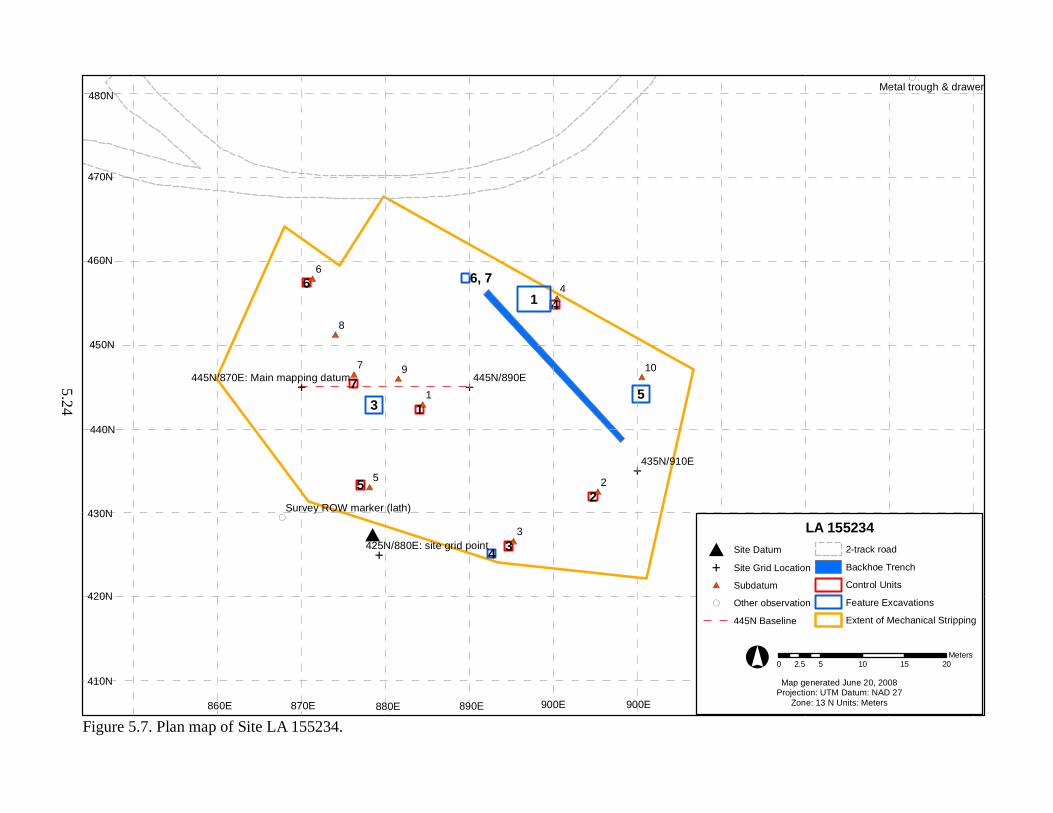
#*
#*
#*
#*
#*
#*
#E
#*
#*
#*
#*
E
E
(
(
E
1
3
2
46
7
5
1
53
4
6, 7
445N/890E
435N/910E
425N/880E: site grid point
445N/870E: Main mapping datum
4
2
3
5
1
9
8
6
7 10
Metal trough & drawer
Survey ROW marker (lath)
LA 155234# Site Datum
E Site Grid Location
#* Subdatum
( Other observation
445N Baseline
2-track road
Backhoe Trench
Control Units
Feature Excavations
Extent of Mechanical Stripping
0 5 10 15 202.5Meters°
Map generated June 20, 2008Projection: UTM Datum: NAD 27
Zone: 13 N Units: Meters
Figure 5.7. Plan map of Site LA 155234.
460N
450N
440N
430N
860E 870E 880E 890E 900E 900E
470N
420N
410N
480N
5.24
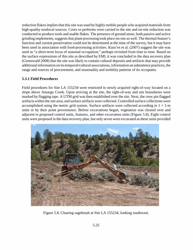
5.25
reduction flakes implies that this site was used by highly mobile people who acquired materials fromhigh-quality nonlocal sources. Cores or preforms were carried to the site and on-site reduction wasconducted to produce tools and usable flakes. The presence of ground stone, both passive and activegrinding implements, suggests that plant processing took place on-site as well. The thermal feature’sfunction and current preservation could not be determined at the time of the survey, but it may havebeen used in association with food-processing activities. Kuru’es et al. (2007) suggest the site wasused as “a short-term locus of seasonal occupation,” perhaps revisited from time to time. Based onthe surface expressions of this site as described by EMI, it was concluded in the data recovery plan(Greenwald 2008) that the site was likely to contain cultural deposits and artifacts that may provideadditional information on its temporal/cultural associations, information on subsistence practices, therange and sources of procurement, and seasonality and mobility patterns of its occupants.
5.3.1 Field Procedures
Field procedures for Site LA 155234 were restricted to newly acquired right-of-way located on aslope above Amargo Creek. Upon arriving at the site, the right-of-way and site boundaries weremarked by flagging tape. A UTM grid was then established over the site. Next, the crew pin flaggedartifacts within the site area, and surface artifacts were collected. Controlled surface collections wereaccomplished using the metric grid system. Surface artifacts were collected according to 1 × 1-munits or by their point provenience. Before excavations began, vegetation was cleared over andadjacent to proposed control units, features, and other excavation units (Figure 5.8). Eight controlunits were proposed in the data recovery plan, but only seven were excavated as these units provided
Figure 5.8. Clearing sagebrush at Site LA 155234, looking southwest.
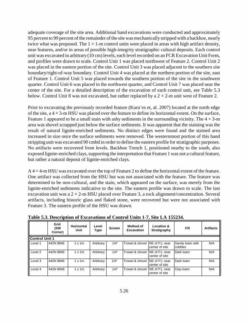
5.26
adequate coverage of the site area. Additional hand excavations were conducted and approximately95 percent to 99 percent of the remainder of the site was mechanically stripped with a backhoe, nearlytwice what was proposed. The 1 × 1-m control units were placed in areas with high artifact density,near features, and/or in areas of possible high-integrity stratigraphic cultural deposits. Each controlunit was excavated in arbitrary (10 cm) levels, each level recorded on an FCR Excavation Unit Form,and profiles were drawn to scale. Control Unit 1 was placed northwest of Feature 2. Control Unit 2was placed in the eastern portion of the site. Control Unit 3 was placed adjacent to the southern siteboundary/right-of-way boundary. Control Unit 4 was placed at the northern portion of the site, eastof Feature 1. Control Unit 5 was placed towards the southern portion of the site in the southwestquarter. Control Unit 6 was placed in the northwest quarter, and Control Unit 7 was placed near thecenter of the site. For a detailed description of the excavation of each control unit, see Table 5.3below. Control Unit 8 was not excavated, but rather replaced by a 2 × 2-m unit west of Feature 2.
Prior to excavating the previously recorded feature (Kuru’es et, al. 2007) located at the north edgeof the site, a 4 × 3-m HSU was placed over the feature to define its horizontal extent. On the surface,Feature 1 appeared to be a small stain with ashy sediments in the surrounding vicinity. The 4 × 3-marea was shovel scrapped just below the surface sediments. It was apparent that the staining was theresult of natural lignite-enriched sediments. No distinct edges were found and the stained areaincreased in size once the surface sediments were removed. The westernmost portion of this handstripping unit was excavated 90 cmbd in order to define the eastern profile for stratigraphic purposes.No artifacts were recovered from levels. Backhoe Trench 1, positioned nearby to the south, alsoexposed lignite-enriched clays, supporting the interpretation that Feature 1 was not a cultural feature,but rather a natural deposit of lignite-enriched clays.
A 4 × 4-m HSU was excavated over the top of Feature 2 to define the horizontal extent of the feature.One artifact was collected from the HSU but was not associated with the feature. The feature wasdetermined to be non-cultural, and the stain, which appeared on the surface, was merely from thelignite-enriched sediments indicative to the site. The eastern profile was drawn to scale. The lastexcavation unit was a 2 × 2-m HSU placed over Feature 3, a rock alignment/concentration. Severalartifacts, including historic glass and flaked stone, were recovered but were not associated withFeature 3. The eastern profile of the HSU was drawn.
Table 5.3. Description of Excavations of Control Units 1-7, Site LA 155234.
Grid (SW
Corner)
HorizontalUnit
LevelType
ScreenMethod ofExcavation
Location &Stratigraphy
Fill Artifacts
Control Unit 1 Level 1 442N 884E 1 x 1m Arbitrary 1/4" Trowel & shovel NE of F1; near
center of siteSandy loam withcobbles
N/A
Level 2 442N 884E 1 x 1m Arbitrary 1/4" Trowel & shovel NE of F1; nearcenter of site
Dark loam N/A
Level 3 442N 884E 1 x 1m Arbitrary 1/4" Trowel & shovel NE of F1; nearcenter of site
Dark loam N/A
Level 4 442N 884E 1 x 1m Arbitrary 1/4" Trowel & shovel NE of F1; nearcenter of site
Clay-loam N/A
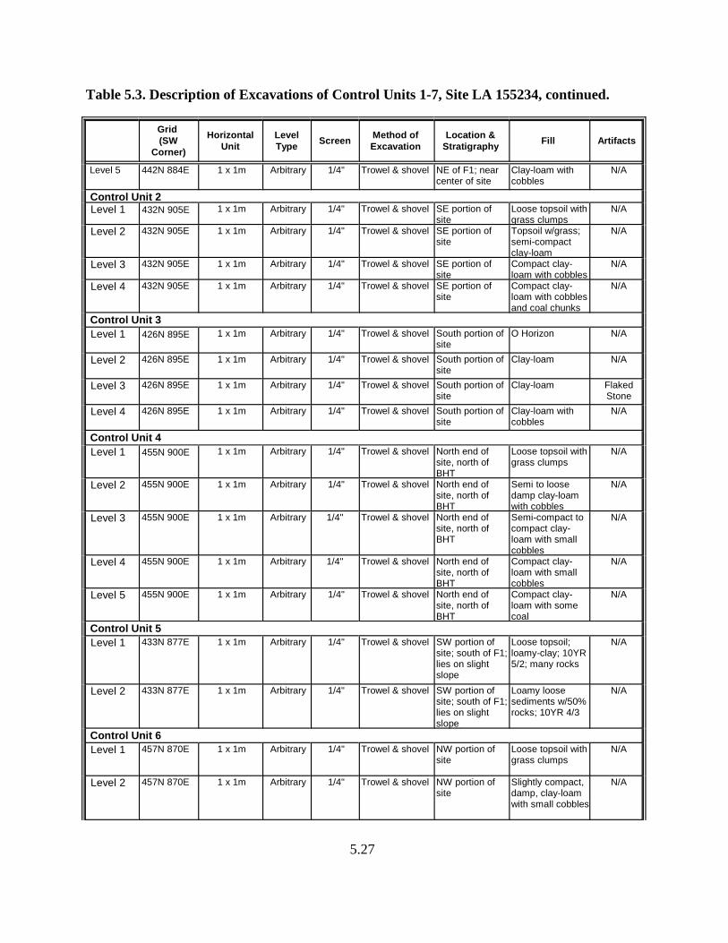
Table 5.3. Description of Excavations of Control Units 1-7, Site LA 155234, continued.
Grid (SW
Corner)
HorizontalUnit
LevelType
ScreenMethod ofExcavation
Location &Stratigraphy
Fill Artifacts
5.27
Level 5 442N 884E 1 x 1m Arbitrary 1/4" Trowel & shovel NE of F1; nearcenter of site
Clay-loam withcobbles
N/A
Control Unit 2 Level 1 432N 905E 1 x 1m Arbitrary 1/4" Trowel & shovel SE portion of
siteLoose topsoil withgrass clumps
N/A
Level 2 432N 905E 1 x 1m Arbitrary 1/4" Trowel & shovel SE portion ofsite
Topsoil w/grass;semi-compactclay-loam
N/A
Level 3 432N 905E 1 x 1m Arbitrary 1/4" Trowel & shovel SE portion ofsite
Compact clay-loam with cobbles
N/A
Level 4 432N 905E 1 x 1m Arbitrary 1/4" Trowel & shovel SE portion ofsite
Compact clay-loam with cobblesand coal chunks
N/A
Control Unit 3
Level 1 426N 895E 1 x 1m Arbitrary 1/4" Trowel & shovel South portion ofsite
O Horizon N/A
Level 2 426N 895E 1 x 1m Arbitrary 1/4" Trowel & shovel South portion ofsite
Clay-loam N/A
Level 3 426N 895E 1 x 1m Arbitrary 1/4" Trowel & shovel South portion ofsite
Clay-loam FlakedStone
Level 4 426N 895E 1 x 1m Arbitrary 1/4" Trowel & shovel South portion ofsite
Clay-loam withcobbles
N/A
Control Unit 4
Level 1 455N 900E 1 x 1m Arbitrary 1/4" Trowel & shovel North end ofsite, north ofBHT
Loose topsoil withgrass clumps
N/A
Level 2 455N 900E 1 x 1m Arbitrary 1/4" Trowel & shovel North end ofsite, north ofBHT
Semi to loosedamp clay-loamwith cobbles
N/A
Level 3 455N 900E 1 x 1m Arbitrary 1/4" Trowel & shovel North end ofsite, north ofBHT
Semi-compact tocompact clay-loam with smallcobbles
N/A
Level 4 455N 900E 1 x 1m Arbitrary 1/4" Trowel & shovel North end ofsite, north ofBHT
Compact clay-loam with smallcobbles
N/A
Level 5 455N 900E 1 x 1m Arbitrary 1/4" Trowel & shovel North end ofsite, north ofBHT
Compact clay-loam with somecoal
N/A
Control Unit 5
Level 1 433N 877E 1 x 1m Arbitrary 1/4" Trowel & shovel SW portion ofsite; south of F1;lies on slightslope
Loose topsoil;loamy-clay; 10YR5/2; many rocks
N/A
Level 2 433N 877E 1 x 1m Arbitrary 1/4" Trowel & shovel SW portion ofsite; south of F1;lies on slightslope
Loamy loosesediments w/50%rocks; 10YR 4/3
N/A
Control Unit 6
Level 1 457N 870E 1 x 1m Arbitrary 1/4" Trowel & shovel NW portion ofsite
Loose topsoil withgrass clumps
N/A
Level 2 457N 870E 1 x 1m Arbitrary 1/4" Trowel & shovel NW portion ofsite
Slightly compact,damp, clay-loamwith small cobbles
N/A
Table 5.3. Description of Excavations of Control Units 1-7, Site LA 155234, continued.
Grid (SW
Corner)
HorizontalUnit
LevelType
ScreenMethod ofExcavation
Location &Stratigraphy
Fill Artifacts
5.28
Level 3 457N 870E 1 x 1m Arbitrary 1/4" Trowel & shovel NW portion ofsite
Compact, damp,clay-loam withcobbles
FlakedStone
Level 4 457N 870E 1 x 1m Arbitrary 1/4" Trowel & shovel NW portion ofsite
Compact clay-loam with cobbles
Bone
Control Unit 7 Level 1 445N 876E 1 x 1m Arbitrary 1/4" Trowel & shovel 6-7m east of
western siteboundary
Loose loamytopsoil
N/A
Level 2 445N 876E 1 x 1m Arbitrary 1/4" Trowel & shovel 6-7m east ofwestern siteboundary
Wet clay-loam,sandstonecobbles; 7.5YR3/2
N/A
Level 3 445N 876E 1 x 1m Arbitrary 1/4" Trowel & shovel 6-7m east ofwestern siteboundary
Wet clay-loam,sandstonecobbles; 7.5YR3/2
FlakedStone,Glass
5.3.2. Feature Descriptions
After the features were exposed, they were photographed in plan view. Each feature was excavatedin cross-section, removing approximately half of the feature fill in order to prepare a view of theirprofiles, which were drawn to scale and each stratigraphic unit described using soil taxonomicnomenclature and a Munsell Soil Color chart to characterize the sediments. Once excavation of eachfeature was completed, a plan view and cross section were drawn to scale. If a feature was discoveredto be natural, the profile was not drawn and samples were not collected. A total of four features wereexcavated and recorded at Site LA 155234. The feature boundaries were defined and half of eachfeature was excavated to define the vertical stratum and to identify whether the feature was culturalversus natural. A total of seven features were assigned on Site LA 155234, although five weredetermined to be non-cultural.
Feature 1: Grid Provenience: 455N, 898-899E (SW corner)Vertical Provenience: SurficialFeature Type: Small stain (non-cultural)
Feature 1 was initially discovered by EMI (Kuru’es et al. 2007) and was described as a thermalfeature remnant. A 4 × 3-m HSU was placed over the feature to define the spatial extent of thefeature. After removing vegetation and overburden, it was apparent the surficial extent of the featurewas due to lignite-enriched sediments and/or a brush fire. Through extensive excavation efforts,Feature 1 was determined to be non-cultural. Geomorphic examination of the area confirmed thefeature’s origin from lignite-enriched sediments, an observation also noted in nearby Backhoe Trench1.
5.29
Feature 2: Grid Provenience: 442N, 880E (SW corner)Vertical Provenience: SurficialFeature Type: Small stain (non-cultural)
Feature 2 was a small ashy stain on the surface near a concentration of gray micaceous ceramics. Thefeature and surface artifacts were located on a slight slope. A 4 × 4-m HSU was placed over thefeature to define the spatial extent of the feature. After stripping approximately 50 cm of sediments,it was apparent the feature had no distinct edges, and the artifacts were only surficial. Feature 2 wasa natural stain derived from lignite-enriched sediment. The stain was defined as non-cultural, withartifacts associated with general use of the site area. Feature 3: Grid Provenience: 449N, 873E (SW corner)
Vertical Provenience: 0.12-0.50 mbdFeature Type: Rock Alignment (non-cultural)
Feature 3 was discovered in the mechanical stripping unit on the western slope of the site, whereapproximately 3 to 4 large rocks formed a northeast-southwest alignment. A 2 × 2-m HSU was placedover the rock alignment to determine the horizontal extent of the feature and to determine if thefeature possessed depth. A total of 38 cm of sediment was removed. Several artifacts were collectedwhile excavating the 2 × 2-m unit, but none were found to be directly associated with Feature 3. Itwas determined Feature 3 (the rock alignment) was non-cultural in origin, representing a portion ofthe bed rock that exhibited a linear pattern. Feature 4: Grid Provenience: 425N, 893E (SW corner)
Vertical Provenience: 0.56-0.63 mbdFeature Type: Small Stain
Feature 4 was discovered in the mechanical stripping unit at the south end of the site. It measured 25cm (10 inches) north-south by 15 cm (6 inches) east-west and contained 7 cm (3 inches) of fill. Thefeature was oval in plan view and basin-shaped in cross section. The feature is slightly oxidized, butnot sufficient for a successful archaeomagnetic sample. Fill consisted of dark organic staining withcharcoal flecks, and one gray micaceous sherd was recovered. A composite radiocarbon sample andmacrobotanical and pollen samples were collected from the fill of this feature.
Feature 5: Grid Provenience: 440N, 910E (SW corner)Vertical Provenience: 0.27-0.29 mbdFeature Type: Stain
Feature 5 was discovered in the mechanical stripping unit at the east end of the site. It measured 70cm (28 inches) north-south by 40 cm (16 inches) east-west and contained 2 cm (0.8 inch) of fill. Thisfeature was elliptical in the plan view and formed a very shallow basin in the cross section. It wasexcavated into the clay-loam deposits underlying the loose top soil. The fill consisted of ash and claymixed with coal and flecks of charcoal. No artifacts were observed. It is possible the feature was used
5.30
for a brief amount of time as little in-situ burning or oxidation was present on the pit edges andbottom of the feature. A composite radiocarbon sample and macrobotanical and pollen samples werecollected from the fill of this feature.
Feature 6: Grid Provenience: 458N, 889E (SW corner)Vertical Provenience: SurficialFeature Type: Stain (non-cultural)
Feature 6 was discovered in the mechanical stripping unit at the north end of the site directly northof Feature 7. The feature was a small, circular black stain. The south half of the feature was excavatedto determine whether it was indeed cultural. Feature 6 had no distinct edges or depth. It wasdetermined that Feature 6 was non-cultural, and the stain originated from lignite-enriched sediments.
Feature 7: Grid Provenience: 458N, 889E (SW corner)Vertical Provenience: SurficialFeature Type: Stain (non-cultural)
Feature 7 was discovered at the north end of the site in the mechanical stripping unit, directly southof Feature 6. Feature 7 was a small surface stain and was bisected to determine whether it possesseddepth and/or cultural materials. Bisection of Feature 7 revealed that no subsurface cultural depositswere present. Feature 7 was determined to be non-cultural in origin.
The remainder of the site area within the right-of-way was mechanically scrapped, resulting in nearly99 percent of the site in the right-of-way examined either by hand or mechanically. Within the MSU,several dark stains (Features 4 through 7) and one possible rock alignment (Feature 3) were identifiedand investigated. Because several control units were excavated and nearly the entire site area wasmechanically stripped, the eighth proposed control unit was not excavated.
Steve Hall, project geomorphologist, visited the site to investigate all exposed stratigraphy on the siteand defined the relationship between cultural deposits and natural stratigraphy (refer to Chapter 9).The site area (staked right-of-way boundary, features, two-track service road for the adjacent powerline, and excavation units) were all mapped using a total station.
5.3.3 Material Culture
5.3.3.1 Ceramics
A small assemblage of 11 sherds was recovered from two general proveniences at the site. Theassemblage was examined by David Greenwald and Dean Wilson. The sherds possess very dark pastewith a mica schist temper, a silver micaceous slip and slightly striated surface. The similarityexhibited by these sherds suggests that they were part of the same vessel, although one sherdrecovered from Feature 4 was 15 to 20 m from the others found on the surface. The sherds indicatethat the vessels they represent would have had very thin walls. Based on the attributes presented
5.31
above, these sherds probably represent Ocate Micaceous, or perhaps, Peñasco Micaceous, producedby the Jicarilla Apache. Gunnerson (1969) places the production of Ocate Micaceous between A.D.
1600 and A.D. 1750; it is possible that production lasted well into the nineteenth century. On Apachesites, Apache ceramics are often found in association with Tewa Polychrome (Gunnerson 1969). AtPecos, Powell (2002:250) noted Ocate Micaceous sherds on very few sites; these sites may representtemporary encampments rather than trade items. At Site LA 155234, the date range of OcateMicaceous pottery compares well with the two radiocarbon dates retrieved from the pit features, inthe broadest of ranges (A.D. 1490–1790) (see Appendix B for radiocarbon dating analyses).
5.3.3.2 Flaked Stone
A total of 142 flaked stone artifacts were recovered from Site LA 155234, the largest assemblage ofall three sites. The assemblage includes, debitage, flakes, cores, projectile points, and other toolforms. Obsidian accounts for nearly half (49 percent) of the assemblage, followed by chert (25.4percent), and chalcedony (13 percent). A large diversity of exotic materials, including WashingtonPass chert, petrified wood and the possible Burro Canyon orthoquartzite, were recovered from thesite, possibly the result of a larger assemblage than recovered from the other two sites.
The majority of the flaked stone assemblage consisted of flake fragments and utilized flakes. Onlyone piece of angular debris was recovered, suggesting core reduction at the site was not intensive andthat many items, possibly including flakes, were brought to the site in some form of completedproduction stage. Several flakes were used as tools, such as scrapers, or exhibited cut/saw wear; oneflake was used as a perforator. Only one flake was recovered from subsurface deposits, indicating thatthe site lacks time depth and suggests a late temporal association.
Five cores were recovered from the site surface. Two cores were of a dark chert material, one wasa tan chert, one was Morrison-like orthoquartzite, and one was a tested Apache tear-type nodule. Twocores displayed battering use wear, indicating subsequent use as hammerstones.
Other flaked stone artifacts were retouched tools, including one uniface, four bifaces, three projectilepoints, and one indeterminate tool. Of three projectile points recovered from the site, two wereidentified as Armijo and the third as an En Medio. These types are representative of the Late Archaicand transitional Late Archaic/Formative periods.
5.3.3.3 Ground Stone
Only three ground stone artifacts were recovered from Site LA 155234. These include twoindeterminate netherstone fragments and one slab metate fragment of fine-grained sandstone. Theslab metate had two opposing grinding surfaces, one was medium textured produced by pecking androughening the surface; the second surface was concave and fine-textured, with bidirectionalstriations.
5.32
5.3.3.4 Historic Artifacts
A minor assemblage of historic artifacts was recovered from surface and subsurface contexts at SiteLA 155234, including one railroad spike and eight pieces of glass. The spike is probably related tothe Denver and Rio Grande Western railroad, which traverses the bottom of the slope below the sitealong Amargo Creek. Its presence on the site may have resulted from visits to the site area byindividuals accessing the slope or power line that parallels the new right-of-way to the north. Theglass is represented by seven pieces of SCA and one piece of an orange-colored shard. The SCAshards were produced during the period associated with the arrival of the railroad until about 1920.The orange-colored glass may be carnival or Depression glass, dating to the 1930s. The presence ofthe historic artifacts is puzzling, although the earliest introduction of the items would not haveoccurred prior to 1880. With the arrival of the railroad and founding of the nearby town of Monero,several sources could have been responsible for these items.
5.3.4 Subsistence Remains
5.3.4.1 Macrobotanical Remains and Pollen
Site LA 155234 produced two cultural features, Features 4 and 5, that were sampled forpaleobotanical remains. Recovered pollen grains and plant parts from these features imply that thevegetation and, therefore, the environmental setting, was very similar to that of today. Sagebrush,pinyon pine, juniper, oak, grasses, rabbit brush, chicory, cheno-ams, and wild buckwheat reflectnative plants that grew on or near the site. Typha pollen suggests either use of cattails or windtransport of cattail pollen from nearby wetlands, probably Amargo Creek. Charred Polygonum seeds(smartweed/knotweed) represent the only taxa that area confidently identified having been used asfoods. The two pollen and two macrofloral samples analyzed from this site indicate that siteoccupants exploited native plants that grew either on the site or in proximity to the site. Charcoalrecovered from these samples indicate that juniper, pinyon pine, oak, and Douglas fir were used asfuel, with oak dominating the fuel woods.
5.3.4.2 Faunal Remains
The four faunal remains from Site LA 155234 were recovered from screened contexts. The fourfragments represent only three specimens; all fragments are of cancellous bone. The dimensions ofthese fragments suggest they may have come from large mammals (Artiodactyla or larger). Becausethe fragments are represented by cancellous tissue, it is impossible to determine what kind oftaphonomic processes, such as burning and/or cut marks, were displayed on the bone in its originalstate.
5.33
5.3.5 Chronology
5.3.5.1 Stratigraphy
Site LA 155234 is situated on a steep slope above Amargo Creek and is located on the north side ofUS 64. The site occurs upon a Cretaceous shale with sandstone, lignite and low-grade coal. Thesedeposits of lignite appear on the surface as well as subsurface and were mistaken in the previousrecordation of the site as surface cultural stains. Upon excavation and mechanical scrapping of thesite area, it was determined that these “dark stains” were produced from natural lignite deposits ratherthan cultural deposits. The natural stratigraphy also has a thin layer of colluvium, which probablydates to the late Holocene. It is unlikely that buried cultural deposits occur at this site because of thediscontinuous deposits of colluvium. Artifacts were recovered from within the colluvium, but it isunknown whether the artifacts are in situ or were displaced from erosional processes.
5.3.5.2 Absolute Dates
One radiocarbon sample was collected from Feature 4 and one from Feature 5; both were submittedto Beta Analytic for analysis. Although the samples were small, they were of sufficient size to runthem as standard AMS samples (see Appendix B for full presentation of Measured Radiocarbon Age,13C/12C Ratio, Conventional Radiocarbon Age, and 2 Sigma Calibrations). Sample 125 from Feature4 produced two possible date ranges calculated at 2 Sigma (95 percent probability) (A.D. 1490–1670and A.D. 1780–1790), both falling within the Protohistoric/Early Historic period. The intercept date,which was calculated at 1 Sigma (68 percent probability), falls at A.D. 1640 on the calibration curve.Sample 129, from Feature 5, produced one date range calculated a 2 Sigma (A.D. 1450–1650), fallingduring the late Prehistoric period into the Protohistoric period. Three intercept dates for this samplefall at A.D. 1520, A.D. 1580, and A.D. 1630 on the calibration curve. The reliability of these datedsamples is considered good based on the similar dates produced and the fact that an Ocate MicaceousGray Ware sherd was also recovered from Feature 4. The production date for Ocate Micaceous Grayhas been placed between A.D. 1600 and A.D. 1750 (Gunnerson 1969).
The lithic assemblage produced three projectile points (see Figure 6.1b-d), two identified as Armijoand the third as an En Medio. These types are representative of the Late Archaic and transitional LateArchaic/ Formative periods. Their presence is suggestive of a Late Archaic component; however, datarecovery efforts resulted in only one piece of flaked stone from subsurface contexts, suggesting thatthe lithic assemblage was restricted to the site’s surface, possibly an indication of the site’s latetemporal association. Although a Late Archaic component is possible, collection and reuse ofprojectile points by Protohistoric and Historic period aboriginal groups is not uncommon. Therefore,given the radiocarbon dates, the presence of Jicarilla Apache pottery, and a general lack of subsurfacedeposits at the site, it is argued that the three points represent collection and reuse by later groups.The geomorphology at the site also suggests late formation processes and a general lack ofaccumulated Holocene age deposits.
5.34
5.2.6 Summary of Field and Analytical Interpretations
Site LA 155234 has been relatively undisturbed by human and mechanical processes, but exposedcobble substrate suggests deflation of or limited accumulation of shallow Holocene deposits. A fainttwo-track road leads to the site from the west to access an overhead line that parallels the site to thenorth. Historic items that date between 1880 and 1920 were found on the site, suggesting historic useor access of the area; however, none of these activities resulted in noticeable impacts to the site.
Although artifacts that can be assigned to at least two temporal periods were recovered from the site,only one occupation has been firmly defined. As argued above, the Late Archaic projectile points arebelieved to represent collection and reuse by later occupants and not a separate occupation.Occupation of the site was of a limited, temporary nature, resulting in only two features that couldconfidently be defined as cultural. A limited number of Ocate Micaceous Gray pottery was alsorecovered from the site, serving as a reliable temporal indicator and supported by the two radiocarbondates retrieved from the two cultural features. The flaked and ground stone assemblage supportslimited use of the site, but included activities related to food processing and flake and tool production.Based on all the information available, the site represents a short-term camp associated with aProtohistoric/Early Historic group, quite possibly the Jicarilla Apache or a group who traded andinteracted with the Jicarilla. Ocate Micaceous Gray pottery is attributed to the Jicarilla, but may havebeen exchanged with other mobile groups such as the Utes or Navajos.
The paleobotanical samples were not particularly revealing. Only small, charred seeds identified asPolygonum seeds (smartweed/knotweed) were recovered that could be interpreted with any confidenceas food resources. Grinding implements support the processing of plant foods. Food processingactivities may have included small game animals and economic plants that included members of thesunflower family, cheno-ams, wild buckwheat, cattail, and grasses. Based on the investigative effortsand data recovered, Site LA 155234 exhibits evidence that it served as a camp site where plant foods,such as small seed-bearing plants, were processed. The presence of three Late Archaic projectile pointsprobably reflects curation activities and reuse by later groups affiliated with the Protohistoric/earlyHistoric period. The pottery suggests the site was occupied by the Jicarilla Apache or groups whoexchanged with them and acquired a vessel commonly associated with the Jicarilla Apache.
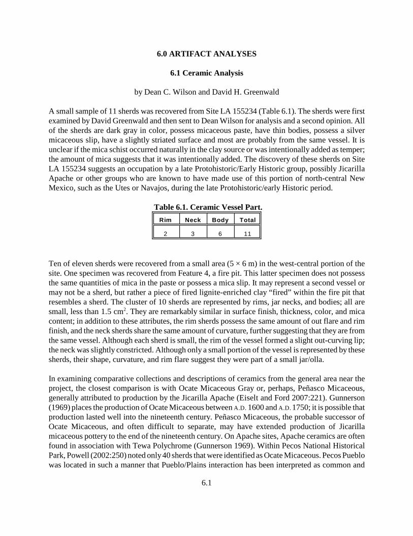
6.1
6.0 ARTIFACT ANALYSES
6.1 Ceramic Analysis
by Dean C. Wilson and David H. Greenwald
A small sample of 11 sherds was recovered from Site LA 155234 (Table 6.1). The sherds were firstexamined by David Greenwald and then sent to Dean Wilson for analysis and a second opinion. Allof the sherds are dark gray in color, possess micaceous paste, have thin bodies, possess a silvermicaceous slip, have a slightly striated surface and most are probably from the same vessel. It isunclear if the mica schist occurred naturally in the clay source or was intentionally added as temper;the amount of mica suggests that it was intentionally added. The discovery of these sherds on SiteLA 155234 suggests an occupation by a late Protohistoric/Early Historic group, possibly JicarillaApache or other groups who are known to have made use of this portion of north-central NewMexico, such as the Utes or Navajos, during the late Protohistoric/early Historic period.
Table 6.1. Ceramic Vessel Part.
Rim Neck Body Total
2 3 6 11
Ten of eleven sherds were recovered from a small area (5 × 6 m) in the west-central portion of thesite. One specimen was recovered from Feature 4, a fire pit. This latter specimen does not possessthe same quantities of mica in the paste or possess a mica slip. It may represent a second vessel ormay not be a sherd, but rather a piece of fired lignite-enriched clay “fired” within the fire pit thatresembles a sherd. The cluster of 10 sherds are represented by rims, jar necks, and bodies; all aresmall, less than 1.5 cm . They are remarkably similar in surface finish, thickness, color, and mica2
content; in addition to these attributes, the rim sherds possess the same amount of out flare and rimfinish, and the neck sherds share the same amount of curvature, further suggesting that they are fromthe same vessel. Although each sherd is small, the rim of the vessel formed a slight out-curving lip;the neck was slightly constricted. Although only a small portion of the vessel is represented by thesesherds, their shape, curvature, and rim flare suggest they were part of a small jar/olla.
In examining comparative collections and descriptions of ceramics from the general area near theproject, the closest comparison is with Ocate Micaceous Gray or, perhaps, Peñasco Micaceous,generally attributed to production by the Jicarilla Apache (Eiselt and Ford 2007:221). Gunnerson(1969) places the production of Ocate Micaceous between A.D. 1600 and A.D. 1750; it is possible thatproduction lasted well into the nineteenth century. Peñasco Micaceous, the probable successor ofOcate Micaceous, and often difficult to separate, may have extended production of Jicarillamicaceous pottery to the end of the nineteenth century. On Apache sites, Apache ceramics are oftenfound in association with Tewa Polychrome (Gunnerson 1969). Within Pecos National HistoricalPark, Powell (2002:250) noted only 40 sherds that were identified as Ocate Micaceous. Pecos Pueblowas located in such a manner that Pueblo/Plains interaction has been interpreted as common and
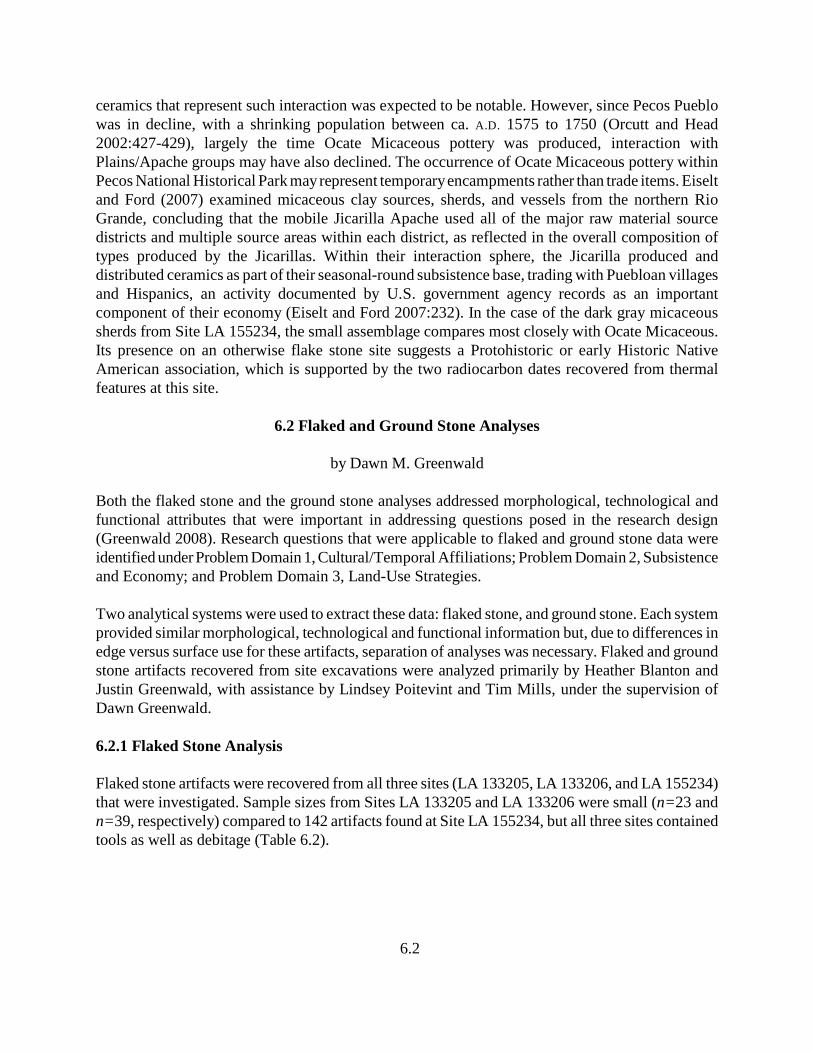
6.2
ceramics that represent such interaction was expected to be notable. However, since Pecos Pueblowas in decline, with a shrinking population between ca. A.D. 1575 to 1750 (Orcutt and Head2002:427-429), largely the time Ocate Micaceous pottery was produced, interaction withPlains/Apache groups may have also declined. The occurrence of Ocate Micaceous pottery withinPecos National Historical Park may represent temporary encampments rather than trade items. Eiseltand Ford (2007) examined micaceous clay sources, sherds, and vessels from the northern RioGrande, concluding that the mobile Jicarilla Apache used all of the major raw material sourcedistricts and multiple source areas within each district, as reflected in the overall composition oftypes produced by the Jicarillas. Within their interaction sphere, the Jicarilla produced anddistributed ceramics as part of their seasonal-round subsistence base, trading with Puebloan villagesand Hispanics, an activity documented by U.S. government agency records as an importantcomponent of their economy (Eiselt and Ford 2007:232). In the case of the dark gray micaceoussherds from Site LA 155234, the small assemblage compares most closely with Ocate Micaceous.Its presence on an otherwise flake stone site suggests a Protohistoric or early Historic NativeAmerican association, which is supported by the two radiocarbon dates recovered from thermalfeatures at this site.
6.2 Flaked and Ground Stone Analyses
by Dawn M. Greenwald
Both the flaked stone and the ground stone analyses addressed morphological, technological andfunctional attributes that were important in addressing questions posed in the research design(Greenwald 2008). Research questions that were applicable to flaked and ground stone data wereidentified under Problem Domain 1, Cultural/Temporal Affiliations; Problem Domain 2, Subsistenceand Economy; and Problem Domain 3, Land-Use Strategies.
Two analytical systems were used to extract these data: flaked stone, and ground stone. Each systemprovided similar morphological, technological and functional information but, due to differences inedge versus surface use for these artifacts, separation of analyses was necessary. Flaked and groundstone artifacts recovered from site excavations were analyzed primarily by Heather Blanton andJustin Greenwald, with assistance by Lindsey Poitevint and Tim Mills, under the supervision ofDawn Greenwald.
6.2.1 Flaked Stone Analysis
Flaked stone artifacts were recovered from all three sites (LA 133205, LA 133206, and LA 155234)that were investigated. Sample sizes from Sites LA 133205 and LA 133206 were small (n=23 andn=39, respectively) compared to 142 artifacts found at Site LA 155234, but all three sites containedtools as well as debitage (Table 6.2).
6.3
Table 6.2. Flaked Stone Artifact Type by Site.
Artifact TypeSite (LA)
Row Total133205 133206 155234
Debitage 2088%*
3180%
11178%
162
Utilized Flake 14%
37%
1410%
18
Core 32%
3
Utilized Core 13%
21%
3
Uniface 11%
1
Biface 14%
37%
43%
8
Notch 14%
11%
2
Denticulate 21%
2
Projectile Point 13%
32%
4
Indeterminate Tool 11%
1
Column Total 23 39 142 204
* Column percentages are rounded and, thus, approximate.
6.2.1.1 Methods
The flaked stone analysis used three analytical formats for three different artifact subsets (debitage,unretouched used flakes, and retouched tools, cores, and hammerstones), based on the type andamount of data that they would provide. Analysis variables included morphological type, materialtype, grain size, reduction stage (debitage and used flakes only) or cortex amount (cores), size(debitage and used flakes only), platform preparation (debitage and flake tools only), facial evaluation(tools only), tool/core condition, use-wear extent and type, maximum measurements (complete toolsand cores only), weight (tools and cores), and a comments section in which miscellaneous attributessuch as core platform symmetry and heat alteration (burning or heat treatment) could be described.Attributes selected were those that would produce the most data applicable to answering questionsposed in the research design. The format in which these attribute data were retrieved was employedfor efficiency purposes, to provide the most data in the shortest amount of time and with the smallestamount of error in content and consistency. Details of analysis methods, results, and datainterpretations follow.
6.4
Morphological Type:
The morphological type variable provided information on both form and function. Debitage wasdescribed as angular debris (shatter), flake fragments, and whole flakes. These were categoriessuggested by Sullivan and Rozen (1985) that are useful in defining some temporal and functionalassemblage attributes. Cores were categorized as cores (no use wear), core tools (use wear other thanhammering/battering), or core-hammerstones (with hammering/battering wear). Hammerstones werenonflaked, cobble tools used for hammering/battering. Specialized tools such as drills and projectilepoints were labeled as such; other tools were described as unifaces or bifaces (depending on whetherthey are retouched on one or two faces) or as used flakes (flakes that exhibited use wear but were notfacially or marginally retouched). Unifaces and bifaces were further described as either flake orcobble forms; bifaces made from tabular materials were described as tabular bifaces. If initial formcould not be determined, the artifact was categorized as either an indeterminate uniface or anindeterminate biface.
Material Type:
Material type was determined by both macroscopic and microscopic (20×) examination. When aspecific material type could not be readily identified, the artifact was placed into one of three generalgeologic groups—igneous, sedimentary, or metamorphic NFS (not further specified)—or categorizedas unidentified. Macroscopic identification of grain size aided in evaluating the nature of rawmaterials used by site inhabitants. The grain-size variable (micro- or cryptocrystalline, fine, medium,or coarse) was a relative measure of material grain size, structure, and flaking characteristics. Micro-or cryptocrystalline materials show no visible grains and have very good flaking characteristics,including conchoidal fracture. Fine-grained materials have visible grains but are small enough toprovide good flaking characteristics so that fractures do not appear to be impeded by granularstructure. Medium-grained materials have a dense but uneven surface, and flake morphology is lessobvious. Materials that are coarse grained contain large crystals or vesicles, their flake morphologyis difficult to identify, and they have poor flaking qualities.
The project area is located in a marine Cretaceous environment that is dominated by the Mancosformation, containing gray and dark gray shale. Also present is the Lewis Formation that containsolive-gray shale, claystone and siltstone (Manley et al. 1987), and the Mesaverde group, composedof three formations. These are overlain with Tertiary sedimentary deposits of “...sand, gravel, clay,and volcanic ash from the San Juan Mountains to the north and the southern tip of the Rockies to theeast” (Chronic 1987:63). The Mesaverde Group contains tan and brown sandstones, gray shale,claystone, ironstone, coal, and limestone (Manley et al. 1987). North-south-oriented dikes intrude intothe shale near and around Lumberton and contain basalt.
Tan, gray, and oolitic cherts used by site inhabitants were probably derived from local sedimentarydeposits. Although mention of oolitic cherts was not made in references accessed by the author,ooliths commonly form in deposits resulting from constantly agitated (i.e., currents) marineenvironments such as those in the project vicinity. Altogether, these three chert colors/types made upa total of 16.7 percent of all project lithic materials.
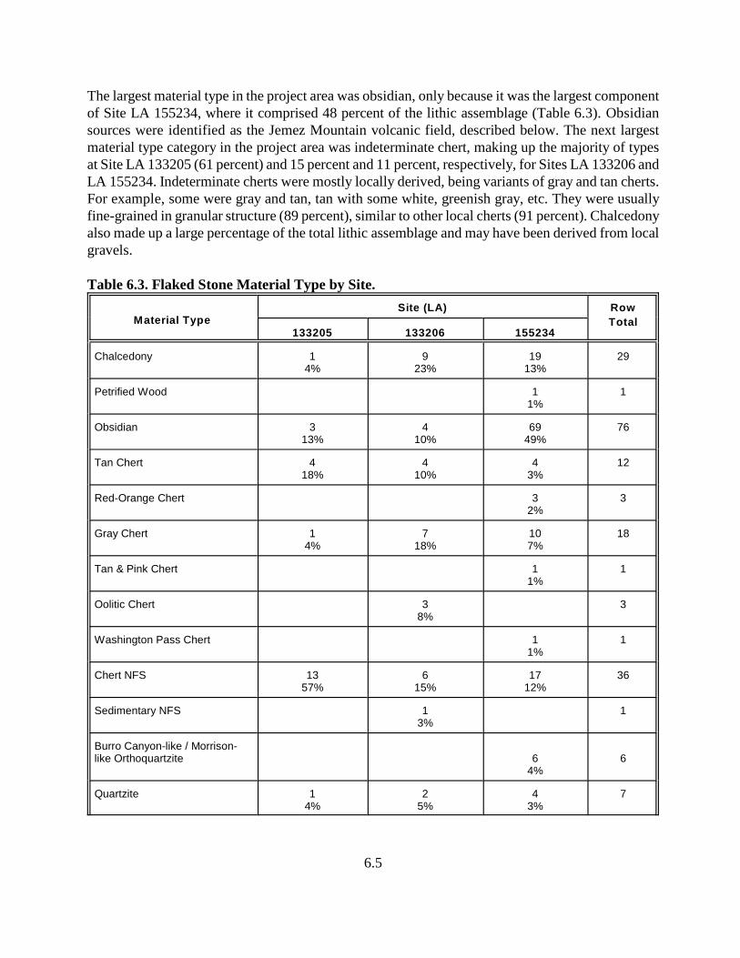
6.5
The largest material type in the project area was obsidian, only because it was the largest componentof Site LA 155234, where it comprised 48 percent of the lithic assemblage (Table 6.3). Obsidiansources were identified as the Jemez Mountain volcanic field, described below. The next largestmaterial type category in the project area was indeterminate chert, making up the majority of typesat Site LA 133205 (61 percent) and 15 percent and 11 percent, respectively, for Sites LA 133206 andLA 155234. Indeterminate cherts were mostly locally derived, being variants of gray and tan cherts.For example, some were gray and tan, tan with some white, greenish gray, etc. They were usuallyfine-grained in granular structure (89 percent), similar to other local cherts (91 percent). Chalcedonyalso made up a large percentage of the total lithic assemblage and may have been derived from localgravels.
Table 6.3. Flaked Stone Material Type by Site.
Material TypeSite (LA) Row
Total133205 133206 155234
Chalcedony 14%
923%
1913%
29
Petrified Wood 11%
1
Obsidian 313%
410%
6949%
76
Tan Chert 418%
410%
43%
12
Red-Orange Chert 32%
3
Gray Chert 14%
718%
107%
18
Tan & Pink Chert 11%
1
Oolitic Chert 38%
3
Washington Pass Chert 11%
1
Chert NFS 1357%
615%
1712%
36
Sedimentary NFS 13%
1
Burro Canyon-like / Morrison-like Orthoquartzite 6
4%6
Quartzite 14%
25%
43%
7
Table 6.3. Flaked Stone Material Type by Site, continued.
Material TypeSite (LA) Row
Total133205 133206 155234
6.6
Basalt 25%
21%
4
Rhyolite 21%
2
Felsic Igneous NFS 13%
1
Igneous NFS 11%
1
Indeterminate 21%
2
Column Total 23 39 142 204
Local materials, in addition to the cherts and chalcedony described above, included sedimentary NFS(not further specified), basalt from dikes, and possibly quartzites and igneous types that may havebeen procured from gravel deposits.
Nonlocal materials included one piece of petrified wood, one artifact of Washington Pass chert,obsidian, and a variety of orthoquartzite that resembled the Burro Canyon and Morrison formations,which are floodplain, fluvial and lacustrine deposits (Leonhardy and Clay 1985:131-133). Theorthoquartzites were only noted at Site LA 155234 and were distinctive in their features and color.The specimens that resembled the Burro Canyon oolitic orthoquartzite were buff in color, with whathas been aptly described as “secondary silica overgrowths” (Leonhardy and Clay 1985:133). Morrisonchert/orthoquartzites are often green, brown, or purple in tones.
Washington Pass chert occurs in the Chuska Mountains, in the San Juan Basin of northwestern NewMexico and approximately 150 miles southwest of the project area. This very distinctive material isactually a chalcedony that manifests mostly in shades of pink and has an opaline quality.
A sample of obsidian artifacts found on project sites were identified through energy dispersive x-rayfluorescence (XRF) spectrometry analysis to be derived from the Jemez Mountain volcanic field ofnorthern New Mexico, and specifically to the Polvadera Peak and Cerro del Medio sources, whichare only two of numerous geological areas related to the Jemez field. These sources are approximately80 miles south of the project area, with Polvadera Peak the northernmost of the two.
The obsidian sample chosen for analysis was based on the artifact’s context within the site andmacroscopic variability among the obsidian collection, in hopes of submitting the full range ofvariation that was available at sites. Most obsidian was a speckled, translucent variety that was found
6.7
to derive from both the Polvadera Peak and Cerro del Medio sources. This variety occurred at all threeproject sites. Another variety was clear or transparent. It was noted as one of three obsidian artifactsat Site LA 133206 and for eight artifacts at Site LA 155234. Of the sample submitted for XRFanalysis, only two of the 15 were of the clear, transparent variety and both were from the Cerro delMedio source. Other macroscopic variability seen among project obsidian were partiallytransparent/partially opaque and “rainbow” features, which were small but distinctive reflections ofrainbow-like colors within the internal structure. Both of these variations were noted in bothPolvadera Peak and Cerro del Medio obsidian-sourced artifacts.
Other Variables:
The reduction-stage variable uses typical terminology (primary, secondary, and tertiary) for debitageand used flakes. Primary flakes were those with 90-100 percent cortex on their dorsal faces; secondaryflakes retained up to 89 percent cortex, and tertiary flakes had no dorsal cortex. Cortical retention oncores was described by percentage.
Each piece of debitage and each used flake was measured with a size chart using a series of graduatedcircles at 1-cm intervals, starting at 1 cm, to provide an ordinal measure of dimensions (see Patterson1982). For example, if a flake fit into the first size interval (Size 1), its maximum dimensions werebetween approximately 0.0 cm and 1.0 cm; a flake that fit into the second size interval (Size 2) hadmaximum dimensions between 1.0 cm and 2.0 cm; a flake that fit into the third size interval (Size 3)had maximum dimensions between 2.0 cm and 3.0 cm; and so on.
The platform preparation variable indicated the type of treatment exhibited on an intact flakeplatform, and only complete platforms were evaluated. Examples of platform preparation valuesinclude completely cortical, cortex plus flaking, one flake scar, two flake scars, multiple flake scars,a point of contact/point-of-force application only, crushed platform, etc. This variable was a meansof determining the amount of energy investment and technological planning that occurred prior toflake removal.
Length, width, and thickness of complete tools were measured to the nearest tenth of a centimeterwith a tape. All tools and cores were weighed on a triple-beam balance scale to the nearest tenth ofa gram. The tool-completeness variable measured the relative amount of a tool that was present (e.g.,< ½ complete, < 3/4 complete, etc.).
Facial evaluation of retouched tools provided data for assessing technological stage of production andthe amount of energy invested in tool production. Face evaluation was a reduction-stage variable,adopted from Phagan (1981), that allowed a consistent description of artifact form through “...rankedevaluation of energy investment into facial regularization or flattening” (Phagan 1981). Eight levelsof facial regularization were possible, ranging from an unworked form with cortex to a highly stylizedform with no cortical surface. Both the ventral and dorsal sides of a tool were considered.
6.8
Any artifact with possible edge damage was observed under a low-power microscope (20×) forevidence of use wear that could provide information on tool function. The determination of use-weartype was made on the basis of striations, polish, flake scars, attrition, and surface rounding and thecontinuous patterning of these attributes. Neusius's (1988) descriptions of use-wear patterning ontools were used to determine wear type. Use-wear extent was described as the amount of tool margineffected by tool use.
6.2.1.2 Site Assemblage Descriptions
Site LA 133205:
This site was a lithic scatter with a hearth and originally assigned to the San Rafael phase (ca. 3500-1800 B.C., Middle to Late Archaic). Following data recovery, Feature 1, the hearth, was radiocarbon-dated to the En Medio phase (800 B.C. to A.D. 400) of the Late Archaic. No diagnostic artifacts wererecovered during excavations.
Only 23 flaked stone artifacts were analyzed from this site. The majority (n=20) were debitage, onewas a utilized flake, one was a notch, and one was a flake biface. None of the artifacts retained anycortex. Of the debitage, most (90 percent) were platform-bearing flakes and flake fragments (Table6.3), suggesting tool manufacturing activities at the site. The utilized flake was a Size 4 fragment ofgray and tan chert with scraping wear on one lateral edge. The bifacial tool was a large flake (5 cmin length) with a crushed platform and a bifacially worked, expanding distal end. Chopping wear wasnoted along the modified edge. The notch was an obsidian whole flake with minimal retouch on onelateral edge that provided a concave surface for scraping. Some use wear was observed on the notch.
Most of the material was locally derived. Obsidian was the only nonlocal material. Despite the smallassemblage, four different material types were present: chalcedony, obsidian, chert, and quartzite.
Lack of cores, cortex, and debitage evidence such as angular debris reinforces the belief that this sitewas inhabited by people whose technology was based on patterns of mobility. A high frequency offlake fragments and platform-bearing flakes rather than whole flakes strengthens the argument aswell.
Site LA 133206:
This site has been described as a multicomponent site consisting of a prehistoric lithic scatter, twohearths, a historic artifact scatter and modern corral. Radiocarbon samples from two features (8 and12) support a Late Archaic period component (En Medio phase) and a Protohistoric/Spanish-periodcomponent. A side-notched obsidian projectile point was found on the site surface (191N 527 E) thatmay represent an early transitional point type, with attributes of both dart and arrow points, suggestinga Late Archaic-period association (see Figure 6.1a).
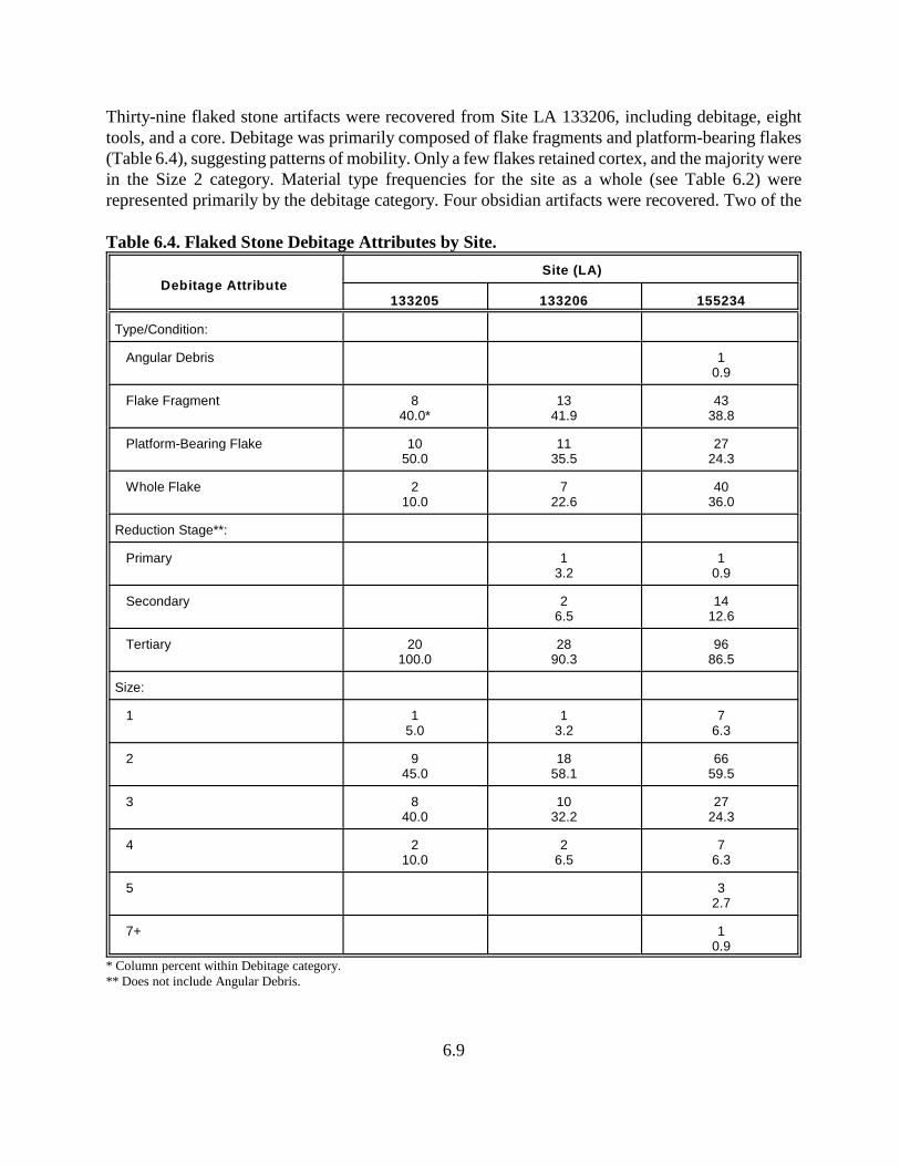
6.9
Thirty-nine flaked stone artifacts were recovered from Site LA 133206, including debitage, eighttools, and a core. Debitage was primarily composed of flake fragments and platform-bearing flakes(Table 6.4), suggesting patterns of mobility. Only a few flakes retained cortex, and the majority werein the Size 2 category. Material type frequencies for the site as a whole (see Table 6.2) wererepresented primarily by the debitage category. Four obsidian artifacts were recovered. Two of the
Table 6.4. Flaked Stone Debitage Attributes by Site.
Debitage AttributeSite (LA)
133205 133206 155234
Type/Condition:
Angular Debris 10.9
Flake Fragment 840.0*
1341.9
4338.8
Platform-Bearing Flake 1050.0
1135.5
2724.3
Whole Flake 210.0
722.6
4036.0
Reduction Stage**:
Primary 13.2
10.9
Secondary 26.5
1412.6
Tertiary 20100.0
2890.3
9686.5
Size:
1 15.0
13.2
76.3
2 945.0
1858.1
6659.5
3 840.0
1032.2
2724.3
4 210.0
26.5
76.3
5 32.7
7+ 10.9
* Column percent within Debitage category.** Does not include Angular Debris.
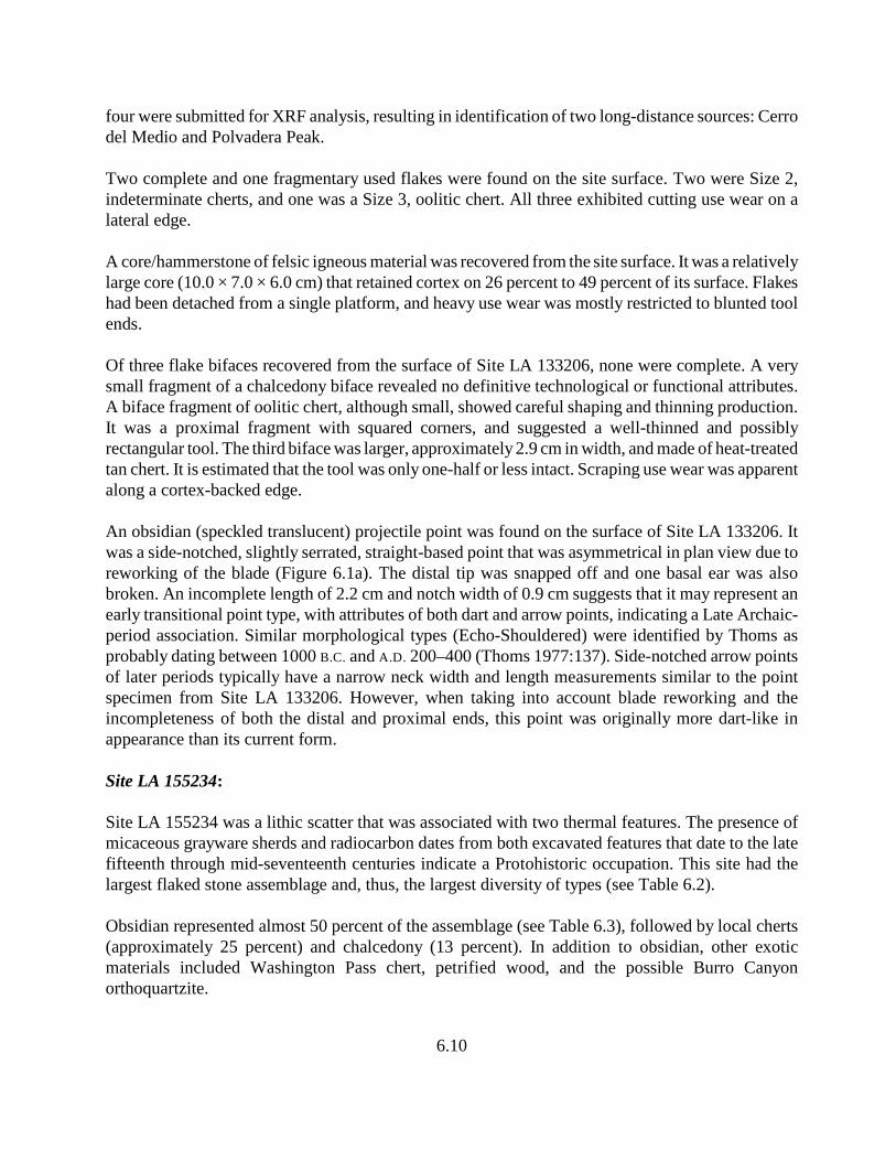
6.10
four were submitted for XRF analysis, resulting in identification of two long-distance sources: Cerrodel Medio and Polvadera Peak.
Two complete and one fragmentary used flakes were found on the site surface. Two were Size 2,indeterminate cherts, and one was a Size 3, oolitic chert. All three exhibited cutting use wear on alateral edge.
A core/hammerstone of felsic igneous material was recovered from the site surface. It was a relativelylarge core (10.0 × 7.0 × 6.0 cm) that retained cortex on 26 percent to 49 percent of its surface. Flakeshad been detached from a single platform, and heavy use wear was mostly restricted to blunted toolends.
Of three flake bifaces recovered from the surface of Site LA 133206, none were complete. A verysmall fragment of a chalcedony biface revealed no definitive technological or functional attributes.A biface fragment of oolitic chert, although small, showed careful shaping and thinning production.It was a proximal fragment with squared corners, and suggested a well-thinned and possiblyrectangular tool. The third biface was larger, approximately 2.9 cm in width, and made of heat-treatedtan chert. It is estimated that the tool was only one-half or less intact. Scraping use wear was apparentalong a cortex-backed edge.
An obsidian (speckled translucent) projectile point was found on the surface of Site LA 133206. Itwas a side-notched, slightly serrated, straight-based point that was asymmetrical in plan view due toreworking of the blade (Figure 6.1a). The distal tip was snapped off and one basal ear was alsobroken. An incomplete length of 2.2 cm and notch width of 0.9 cm suggests that it may represent anearly transitional point type, with attributes of both dart and arrow points, indicating a Late Archaic-period association. Similar morphological types (Echo-Shouldered) were identified by Thoms asprobably dating between 1000 B.C. and A.D. 200–400 (Thoms 1977:137). Side-notched arrow pointsof later periods typically have a narrow neck width and length measurements similar to the pointspecimen from Site LA 133206. However, when taking into account blade reworking and theincompleteness of both the distal and proximal ends, this point was originally more dart-like inappearance than its current form.
Site LA 155234:
Site LA 155234 was a lithic scatter that was associated with two thermal features. The presence ofmicaceous grayware sherds and radiocarbon dates from both excavated features that date to the latefifteenth through mid-seventeenth centuries indicate a Protohistoric occupation. This site had thelargest flaked stone assemblage and, thus, the largest diversity of types (see Table 6.2).
Obsidian represented almost 50 percent of the assemblage (see Table 6.3), followed by local cherts(approximately 25 percent) and chalcedony (13 percent). In addition to obsidian, other exoticmaterials included Washington Pass chert, petrified wood, and the possible Burro Canyonorthoquartzite.
6.11
Figure 6.1. Projectile points: (a) Site LA 133206, Record No. 5; (b) Site LA 155234, Record No. 6;(c) Site LA 155234, Record No. 48; (d) Site LA 155234, Record No. 119.
As with the other two sites, debitage at Site LA 155234 consisted primarily of flake fragments,although the frequency of whole flakes was higher at this site than the other two. Variation infrequency among sites may be a function of cultural or temporal affiliation, or it may simply be dueto smaller sample sizes from Sites LA 133205 and LA 133206.
Only one piece of angular debris was analyzed from Site LA 155234, indicating core reduction wasnot intensive. A single primary flake was represented within the collection, and most flakes werecortex-free (86.2 percent). In general, debitage was smaller in size than at the other two sites, althoughnot significantly (see Table 6.4).
6.12
Used flakes followed many debitage attributes. Obsidian was the primary material type (n=6) forutilized flakes. Chalcedony and local chert represented 21 percent (n=3) each, and there was onespecimen each of quartzite and possible Burro Canyon orthoquartzite. Tools were eithermicrocrystalline-grained or fine-grained in structure, and only two had remnants of cortex. Sizeranged from 2 to 5, slightly larger than debitage. Flakes used as tools were typically larger thandebitage due to the necessity of either holding or hafting the tool for manipulation. Five (36 percent)used flakes were complete, and eight (57 percent) exhibited scraping wear. Four (29 percent) hadcut/saw wear, one had indeterminate wear, and one was used as a perforator. This latter tool had anelongated, broken margin with rotation scars and abrasion at the constricted end. Only one used flake(Record No. 140) was found subsurface (Level 3, CU 3); the rest were found on the site surface.
Five cores were recovered from the site surface. One was a tested Apache tear-type nodule, althoughit was flat rather than rounded, with a single flake removed. It retained over 50 percent of its cortexand measured 2.8 cm in length. Other cores were of dark gray chert (n=2), tan chert (n=1), andMorrison-like orthoquartzite (n=1). Weights ranged from the small obsidian tested nodule of 5.0 gto a large core of tan chert (248.9 g), with a mean of 63.0 g. Reduction patterns varied among cores:one platform (n=1); bifacial platforms (n=1); parallel platforms (n=1); and multidirectional platforms(n=2). Three of the specimens retained no cortex and two retained over 50 percent. Two coresexhibited battering use wear, indicating subsequent use as a hammerstone.
Fourteen artifacts in the assemblage were retouched tools: a uniface, bifaces, a notch, denticulates,projectile points, and one indeterminate tool. The indeterminate chert tool was too fragmentary foridentification, but an intact edge had at least been unifacially worked and exhibited possible choppingwear.
The flake uniface was a fragment with a very small intact edge showing a steep edge angle. It hadbeen heat-treated, made of fine–grained chert, and had no use wear on the small piece of intact edge.Four biface fragments were also analyzed. Three were of obsidian and the fourth was of chalcedony.Due to their fragmentary state, little data could be gathered. One exhibited cutting/sawing wear, butuse wear on the other three could not be determined. One obsidian biface (Record No. 128) may havebeen a projectile point stem.
A notch was manufactured on the distal margin of an obsidian flake and showed slight scraping wear.A damaged lateral margin may also have exhibited the remnants of a denticulated edge. The nearlyintact flake width measured 1.9 cm; however, flake length was incomplete.
A complete denticulated tool (2.4 × 1.9 × 0.7 cm) was made of chert and produced with unifacialflake scars that were invasive to the dorsal face. The scars thinned the tool, causing the denticulatededge to be acute and fragile. Another denticulate was produced from an obsidian flake (Size 3).Multiple unidirectional flake scars were present on both lateral margins, although some edge damagehad occurred. Scraping wear was noted on one edge, in the vicinity of the largest scar, possibly alsoused as a notch. Possible cutting/sawing wear was noted on the opposite edge.
6.13
Three projectile points were recovered from the site surface. Two points were identified as Armijo,and the third point was an En Medio, types representative of the Late Archaic period.
Armijo points are components of the Armijo phase (ca. 1800-800 B.C.) of the Oshara Tradition ofnorthern New Mexico. Armijo points are generally smaller San Jose forms, with prominent earssometimes flaring out wider than the blade, and concave bases. One of the Armijo points (see Figure6.1b) was nearly complete, except for a snapped distal tip. It was made of obsidian and had atriangular blade, approximately twice the length of the stem, and basal ears that were wider than theshoulders. Incomplete length dimension was 26 mm, maximum width at the base was 17 mm, andit was 4 mm in thickness. The stem was ground on the sides and base, and one blade edge hadadditional use-wear damage that was identified as cutting. A snapped tip indicated projectile use, andthe additional lateral cutting wear suggested re-use as a knife.
The second Armijo point (see Figure 6.1c) was made of tan Burro Canyon-like orthoquartzite. It wasmissing the entire distal end and a portion of one basal ear. It had an incomplete length of 22 mm, awidth of 18 mm, and a thickness 5 mm. The blade was serrated and the sides of the stem were ground.The shoulders appeared either equal to or slightly wider than the basal ears. An adherent was notedon the stem sides and base, possibly resin remaining from hafting.
The En Medio type was named after the En Medio phase (ca. 800 B.C.–A.D. 400) of the Osharatradition (Irwin-Williams 1973), the type region that lies between the Puerco and Jemez Rivers ofnorthwest New Mexico. The En Medio-like point from Site LA 155234 was nearly complete, missingthe distal tip and a portion of one lateral blade/tang and one notch and nearby stem (see Figure 6.1d).It had a wide blade, with an incomplete maximum width of 21 mm, that had been reworked at thedistal end, forming shoulders on either edge approximately 10 mm above the corner notches. It wasmade of obsidian and had a maximum (incomplete) length of 26 mm and was 5 mm thick.
6.2.2 Ground Stone Analysis
A total of 15 ground stone artifacts from Sites LA 133205, LA 133206, and LA 155234 werecollected and analyzed for morphological, technological and functional data. Thirteen were composedof fine-grained sandstone, and two were made of alluvial cobbles of felsic igneous material (onemedium-grained and one coarse-grained). The small project assemblage contained only grindingimplements. All but one artifact were fragments; the single complete artifact was partially shaped intoa mano.
6.2.2.1 Methods
Attributes recorded during the analysis included morphological type; shape in plan view; grindingsurface profile; artifact condition; material type; grinding surface texture; production investment;production technique; reuse, recycling, or reshaping; surface adhesions; and artifact dimensions.Other observations such as heat treatment, additional modifications, number of grinding surfaces, orspecific wear were noted when present.
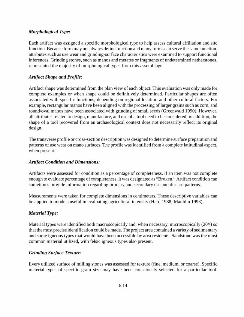
6.14
Morphological Type: Each artifact was assigned a specific morphological type to help assess cultural affiliation and sitefunction. Because form may not always define function and many forms can serve the same function,attributes such as use wear and grinding-surface characteristics were examined to support functionalinferences. Grinding stones, such as manos and metates or fragments of undetermined netherstones,represented the majority of morphological types from this assemblage.
Artifact Shape and Profile:
Artifact shape was determined from the plan view of each object. This evaluation was only made forcomplete examples or when shape could be definitively determined. Particular shapes are oftenassociated with specific functions, depending on regional location and other cultural factors. Forexample, rectangular manos have been aligned with the processing of larger grains such as corn, andround/oval manos have been associated with grinding of small seeds (Greenwald 1990). However,all attributes related to design, manufacture, and use of a tool need to be considered; in addition, theshape of a tool recovered from an archaeological context does not necessarily reflect its originaldesign.
The transverse profile or cross-section description was designed to determine surface preparation andpatterns of use wear on mano surfaces. The profile was identified from a complete latitudinal aspect,when present.
Artifact Condition and Dimensions:
Artifacts were assessed for condition as a percentage of completeness. If an item was not completeenough to evaluate percentage of completeness, it was designated as “Broken.” Artifact condition cansometimes provide information regarding primary and secondary use and discard patterns.
Measurements were taken for complete dimensions in centimeters. These descriptive variables canbe applied to models useful in evaluating agricultural intensity (Hard 1988; Mauldin 1993).
Material Type:
Material types were identified both macroscopically and, when necessary, microscopically (20×) sothat the most precise identification could be made. The project area contained a variety of sedimentaryand some igneous types that would have been accessible by area residents. Sandstone was the mostcommon material utilized, with felsic igneous types also present.
Grinding Surface Texture:
Every utilized surface of milling stones was assessed for texture (fine, medium, or coarse). Specificmaterial types of specific grain size may have been consciously selected for a particular tool.
6.15
Additionally, grinding tools were often intentionally roughened to achieve a desired surface texturefor a particular function. Therefore, both material grain size and surface modification were consideredduring the classification of grinding surface texture. Models based on material type and texture(Bartlett 1933; Greenwald 1990; Halbirt 1985; Stone 1994) suggest that different foodstuffs requireddifferent degrees of coarseness to be processed efficiently.
Production Investment and Technique:
All ground stone artifacts were assessed for production investment or manufacture, or the amount ofshaping each artifact had undergone. Modification of only the grinding surface was defined as“minimally altered.” If less than half of the tool was altered, it was “shaped.” If more than half of theentire form was altered, it was considered “well-shaped.” Those that exhibited production over all ornearly all of its form were considered to be “completely shaped.” This attribute represents the amountof energy invested in the manufacturing process and can help to determine whether energy investmentcorrelates with a particular artifact type, function, or other factors. Production techniques such asflaking, pecking, grinding, or any combination of these, were determined from traces of manufactureretained on artifacts.
Multiple Functions:
Multiple functions were described as either similar use (“reuse”), different shape (“reshaped”),different uses at different times (“recycled”), more than one use that probably occurred concurrently(“multiple use”), indeterminate, or a combination of these. These criteria can be useful in evaluatingcultural preferences, interaction, and technological organization, as well as tool function, exploitation,and application.
Adhesions:
Artifacts with potential surface adhesions were briefly scanned under low power (20×) to providemore information on tool function. Surface adhesions such as pigment on hand stones might suggestindirect evidence of pigment processing. Other possible adhesions include clay, ash, charcoal, oil, andphytoliths.
Comments:
This category was used to describe attributes that were not incorporated in the system listed above.Examples include the number of use surfaces, use wear characteristics, and evidence of burning.
6.2.2.2 Site Assemblages
Table 6.5 summarizes ground stone artifact type by site. Morphological types at all sites wererepresented by grinding tools. Non-utilitarian artifacts were not recorded or collected.
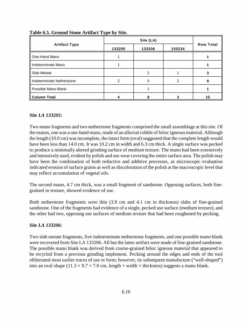
6.16
Table 6.5. Ground Stone Artifact Type by Site.
Artifact TypeSite (LA)
Row Total133205 133206 155234
One-Hand Mano 1 1
Indeterminate Mano 1 1
Slab Metate 2 1 3
Indeterminate Netherstone 2 5 2 9
Possible Mano Blank 1 1
Column Total 4 8 3 15
Site LA 133205:
Two mano fragments and two netherstone fragments comprised the small assemblage at this site. Ofthe manos, one was a one-hand mano, made of an alluvial cobble of felsic igneous material. Althoughthe length (10.0 cm) was incomplete, the intact form (oval) suggested that the complete length wouldhave been less than 14.0 cm. It was 10.2 cm in width and 6.3 cm thick. A single surface was peckedto produce a minimally altered grinding surface of medium texture. The mano had been extensivelyand intensively used, evident by polish and use wear covering the entire surface area. The polish mayhave been the combination of both reductive and additive processes, as microscopic evaluationindicated erosion of surface grains as well as discoloration of the polish at the macroscopic level thatmay reflect accumulation of vegetal oils.
The second mano, 4.7 cm thick, was a small fragment of sandstone. Opposing surfaces, both fine-grained in texture, showed evidence of use.
Both netherstone fragments were thin (3.9 cm and 4.1 cm in thickness) slabs of fine-grainedsandstone. One of the fragments had evidence of a single, pecked use surface (medium texture), andthe other had two, opposing use surfaces of medium texture that had been roughened by pecking.
Site LA 133206:
Two slab metate fragments, five indeterminate netherstone fragments, and one possible mano blankwere recovered from Site LA 133206. All but the latter artifact were made of fine-grained sandstone.The possible mano blank was derived from coarse-grained felsic igneous material that appeared tobe recycled from a previous grinding implement. Pecking around the edges and ends of the toolobliterated most earlier traces of use or form; however, its subsequent manufacture (“well-shaped”)into an oval shape (11.3 × 9.7 × 7.0 cm, length × width × thickness) suggests a mano blank.
6.17
The slab metates were identified as such due to their durability, even in fragmented form. The largerfragment was 11.0 cm thick, and the smaller fragment was 5.7 cm thick. Both artifacts had grindingsurfaces roughened by pecking, creating a medium-grained platform.
Indeterminate netherstone fragments were small in size and between 1.8 cm and 2.9 cm in thickness,so that they may have been part of either a larger slab metate or a small grinding slab or lapstone.Each specimen had a fine-grained, planar surface with evidence of grinding wear.
Site LA 155234:
Ground stone from this site was composed of two indeterminate netherstone fragments and one slabmetate fragment of fine-grained sandstone. The netherstone fragments were small, made of fine-grained sandstone, and had medium-grained grinding surfaces. One of the fragments had a completethickness of 2.4 cm, and the other was incomplete at 3.3 cm.
The slab metate had a complete length of 38.1 cm. The width was incomplete (26.4 cm), and it hada complete thickness of 8.7 cm. It had two opposing grinding surfaces of different textures. Onesurface measured 37.0 × 24.5 cm (length × width), was approximately planar and of medium texture,which was produced from pecking. The second surface was smaller (19.5 × 15.0 cm), slightlyconcave, and fine-textured. Bidirectional striations, oriented lengthwise, were visible on the smallersurface.
6.2.3 Problem Domains
Problem domains and research questions posed for this project that are applicable to flaked andground stone data include Cultural/Temporal Affiliations, Subsistence and Economy, and Land-UseStrategies. The small amount of ground stone artifacts recovered from the project area and smallamount of flaked stone from Sites LA 133205 and LA 133206 do not provide a statistically validsample for defining patterns of behavior. Instead, most data will, of necessity, be drawn from Site LA155234, the site with the largest flaked stone assemblage, to characterize the cultural componentsrepresented there. Data from the other sites will be included to describe what additional evidence, orlack thereof, is available to address the research questions.
6.2.3.1 Cultural/Temporal Affiliations
Determinations of general or specific temporal affiliation based on flaked and ground stoneassemblages usually are indicated by data such as artifact types/morphology/style, including projectilepoint types, variability within assemblage variables such as material type, and technological attributes.Through time, a population might change preference for artifact style or basic artifact form. Thesechanges could have been due to functional modifications, such as the evolution of spear and dart toarrow technologies or the evolution of trough to formal slab metates in the Ancestral Pueblo region,or they might have been due to a changing emphasis in religious, social or economic structures, suchas the stylistic variations seen through time of censers and palettes in the Hohokam region.
6.18
Obsidian hydration is another relative dating method for lithic assemblages, determining whether oneartifact is younger or older than another. When obsidian becomes exposed to the atmosphere for thefirst time, it starts to absorb water from the air (Robinson 2008). This moisture-permeated area, orrind, can be thin-sectioned and observed under the microscope when it reaches a thickness of about0.5 microns (Northwest Research Obsidian Studies Laboratory 2008). The thicker the rind, the longerthe surface exposure (supposedly via core or tool reduction). However, both known and unknownenvironmental or cultural factors may cause variation in hydration rates. One of the known factorsis that the degree of hydration is different for different obsidians (The Regents of the University ofCalifornia 2008). Therefore, interpretation of hydration bands must be approached with caution.
A sample of obsidian artifacts from the project area underwent obsidian hydration band analysis atOriger’s Obsidian Laboratory, California (see Appendix C). Although data suggests that the Archaicoccupation at Site LA 155234 was earlier than the smaller sites and that occupation at Site LA 133206was earlier than at Site LA 133205, results were inconclusive due to small samples at the smallersites. Site LA 133205 had a single artifact as an obsidian hydration sample, LA 133206 had twoartifacts as a sample, and Site LA 155234 had 12 artifacts. The latter site had two possible temporalcomponents widely differing in age — Late Archaic and Protohistoric — so that if obsidian was usedand discarded on the site during each of those time periods then the rind measurements are expectedto be quite variable. There was indeed a very wide range of mean rind measurements at this site, fromas narrow as 1.8 microns to as wide as 7.6 microns, with most clustering between 4 microns and 5microns. More variation was found in the Polvadera Peak obsidian at this site, but it was also themore frequent of the two types (Polvadera Peak=7 versus Cerro del Medio=3; two specimens hadbeen too small for XRF sourcing). Going on the assumption that the most narrow rind (1.8 microns)belongs to the Protohistoric period occupation, then the Late Archaic occupation, associated with theprojectile points from the same site (see below), has a wide range of hydration rind measurements,unless an even earlier occupation existed at the site or obsidian was scavenged from earlier sites.Obsidian from contexts that pre-date the Late Archaic period would be represented by site outliers,such as rind thicknesses of 6 microns and 7.6 microns.
Hydration rinds of both specimens from Site LA 133206 were very close: 3.2 microns, and 3.6microns. The thicker rind belonged to an artifact of Cerro del Medio obsidian; the other specimen wasfrom Polvadera Peak. The single obsidian specimen from Site LA 133205, from Polvadera Peak, hada rind mean measurement of 2 microns, within the range of the most narrow rinds at Site LA 155234.
Projectile point typologies are a primary method of documenting relative temporal assignment ofcultural contexts, particularly when absolute chronometrics are lacking. Typologies are limited by theintent of the classification system itself—to pigeon-hole an artifact into an idealized shape—whenthere may be a number of factors that serve to modify and vary the shape from the ideal. Not the leastof these factors is the human creative spirit, which may act to individualize form by incorporatingminute changes during tool manufacture. Another is that well-discussed mode of behavior known ascuration that conserves well-produced and potentially multi-functional tools such as projectile pointsthat are maintained for future use and possibly for other tasks (i.e., knife or drill) through modification(Bamforth 1986:38). However, projectile points also play a significant role in re-use or utility over

6.19
long periods of time, with modification of both blade and hafting portions of the tool. When re-useoccurs by a later cultural element (i.e., a Formative-period person using an Archaic-period point), onemight argue that refuse from an earlier period has returned into the record as a functional tool.
The most widely used projectile point typology for northern New Mexico is based on the Osharatradition, devised by Irwin-Williams in the early 1970s and based on site data for a region that liesbetween the Puerco and Jemez Rivers of northwest New Mexico (Thoms 1977:36). It embraces theArchaic and early ceramic periods and consists of the following phases: Jay (ca. 5500–4800 B.C.);Bajada (ca. 4800–3300 B.C.); San Jose (ca. 3300–1800 B.C.); Armijo (ca. 1800–800 B.C.); En Medio(ca. 800 B.C.–400 A.D.); Trujillo (A.D. 400–600); Sky Village (ca. A.D. 600–700); and Loma Alta (ca.A.D. 700–850) (Thoms 1977:36-41).
Projectile point types identified from project sites (Figure 6.2) included two Armijo points and oneEn Medio point from Site LA 155234. The presence of these types suggests a site component datingto the Late Archaic period. One projectile point was collected from Site LA 133206; however, it didnot conform to typological styles that define the Oshara tradition. Instead, this reworked toolresembled a point (Echo-Shouldered) identified by Thoms (1977:137) as associated with the end ofthe Late Archaic period.
Figure 6.2. Late Archaic period projectile points (from upper left, clockwise):Site LA 133206, Record No. 5; Site LA 155234, Record No. 6;
Site LA 155234, Record No. 48; and Site LA 155234, Record No. 119.
6.20
Variability within assemblage variables, such as artifact type or material type, can sometimes informon temporal or cultural affiliation. Changes in specific artifact types such as metate or axe forms havebeen associated with an evolutionary sequence or regional diversity within the Southwest. Forexample, ridges on three-quarter-grooved axes in the Phoenix Basin are commonly assigned to anarrow time span during the Early Colonial period (Greenwald 1993a:329), and metates with preparedshelves on the closed end are noted most often in the Four Corners region (Greenwald 1993b:124).
Material type variability among assemblages can also be a temporally sensitive indicator in somecircumstances. A dramatic increase in obsidian use in the Phoenix Basin was useful in determiningdifferences between Classic and post-Classic period habitations (Spurr and Greenwald 1995:217-224), and diversity of exotic materials might help to orient trade routes and procurement territoriesthat are in place during particular time periods.
Material type variation did occur among project site assemblages. However, variability occurredprimarily between Sites LA 155234 and the other two sites (LA 133205 and LA 133206), which havemuch smaller sample sizes, so that caution should be exercised when interpreting these data. Withouta larger sample it is uncertain whether variability was due to cultural affiliation, temporal affiliation,or site function. Site LA 155234 had a significantly higher percentage of obsidian than the other twosites, a concurrently lower amount of local materials such as chert, and a relatively higher frequencyof nonlocal materials other than obsidian (see Table 6.3). Obsidian frequencies at Sites LA 133205and LA 133206 were 5 percent and 10 percent, respectively, compared to 48 percent at Site LA155234. Local chert percentages were 85 and 43, respectively, for Sites LA 133205 and LA 133206,compared to 24 percent at Site LA 155234. Finally, the only specimens of petrified wood and BurroCanyon-like and Morrison-like orthoquarzites came from Site LA 155234. However, in regard tothese latter materials, it must be stated that the more artifacts within a site sample, the more internalvariability is expected. In the same vein, flaked stone artifact types were more diverse at Site LA155234, so that more specialized forms (notch, denticulate, projectile point) were identified. On theother hand, it may be noteworthy that there were fewer ground stone tools (n=3) at Site LA 155234than at either of the other two sites (n=4 and 8). In fact, when taking the entire stone assemblage intoaccount (flaked and ground stone), the relative frequency of all ground stone at Site LA 155234 was2 percent compared with 16 percent at Site LA 133205 and 17 percent at Site LA 133206. In addition,although Site LA 133205 had the smallest number of stone artifacts of the three sites, it contained theonly used manos in the project area. No manos were recovered from Site LA 155234. The generalsparsity of heavy food-processing equipment at Site LA 155234 seems to be offset by a greaternumber of special-function flaked stone tools.
In summarizing assemblage variability among sites, Site LA 155234 had significantly more obsidian,exotic materials other than obsidian, and less local material compared to the other two sites, whichhad relatively low obsidian frequencies, high frequencies of local materials, and no exotics other thanobsidian. However, Site LA 155234 did not contain as much ground stone as the other two sites.Instead, ground stone tools were relatively sparse at the larger site, although specialized flaked stonetools were more abundant.

6.21
There was very little variability in technology among site assemblages. Variation that did occur waseither slight or masked by sample size differences among site collections. Few cores and even fewerangular debris were noted at sites. Most flakes did not retain any cortex. Flake size was fairlycomparable among sites, and the ratio of unretouched-to-retouched tools was very similar. Site LA155234 had the highest frequency of whole flakes and the lowest frequency of platform-bearingflakes, but the relative frequency of flake fragments was comparable among sites. Differences ofwhole flake and platform-bearing flake percentages may have been a function of material typevariability among sites.
6.2.3.2 Subsistence and Economy
Subsistence activities of mobile hunters and gatherers is the primary focus of this problem domain.Application of flaked and ground stone artifact assemblages to subsistence and economic issues takethe form of procurement, processing and production activities. What resources were exploited, howwere they acquired and processed, what tools were used, and what production methods wereemployed during manufacture? Because the third problem domain, Land-Use Strategies, is discussedbelow, specific reference to exploitation mechanisms will be addressed under that heading.
Material Usage
Flaked Stone. Over 90 percent of lithic materials used on the three sites were either microcrystallinegrained or fine grained in structure. Microcrystalline-grained resources were primarily obsidian,utilized predominantly by the inhabitants of Site LA 155234. Fine-grained resources were mostlylocal cherts, which were the primary materials used by inhabitants at Sites LA 133205 and LA133206. Lower quality but stronger materials such as basalt did occur locally, but local cherts werepreferred for tool production.
Sites LA 133205 and LA 133206 had primarily fine-grained materials; Site LA 155234 materials werepredominantly microcrystalline grained. Three microcrystalline-grained lithics, all obsidian, wererecovered from Site LA 133205. Two of these were the only retouched tools in the collection, and thethird was a flake fragment from the same feature as the notch. At Site LA 133206, there were eightmicrocrystalline-grained lithics. Two were retouched tools (50 percent of retouched tools), one wasa utilized flake (33 percent of utilized flakes), and the rest were debitage (16 percent of debitage).Sixty-seven percent of retouched tools at Site LA 155234 were microcrystalline-grained, 50 percentof utilized flakes were microcrystalline grained, and 55 percent of debitage were the highest qualitygrain size.
Although high-quality materials such as obsidian appear to have been worked (produced and/ormaintained) at each of the sites, there is great variability of the ratio of microcrystalline-grainedtools:debitage among sites. Site LA 133205, which admittedly has the smallest sample (n=23), hasa ratio of 2:1, Site LA 133206 (n=39) has a ratio of 3:5, and Site LA 155234 (n=142) has a ratio ofapproximately 1:4. These figures suggest an increasing amount of microcrystalline-grained toolproduction and/or maintenance on-site from the smallest to the largest site, and corresponds with the
6.22
amount of high-quality materials recorded at each of the sites. Site LA 133205, which had thesmallest amount of high-quality material (in this case, obsidian), also had the least amount ofevidence of maintenance or manufacture of obsidian tools (one Size-1 flake fragment). On the otherend of the scale, Site LA 155234 had the largest amount of microcrystalline-grained material anddebitage associated with tool manufacture and/or maintenance. Most was obsidian (88 percent of totalmicrocrystalline-grained materials at the site), although others included chalcedony (8 percent),indeterminate chert (3 percent), and Washington Pass chert (1 percent). None of the cores were fromthis grain-size category.
All of the tools at Site LA 133205 were microcrystalline grained, but, at the other two sites, toolswere almost evenly split between microcrystalline or fine grained. At Site LA 133206, four tools (twoused flakes and two bifaces) were fine grained, compared with three (one used flake, one biface, andone projectile point) that were microcrystalline grained. Retouched versus unretouched tools at SiteLA 155234 showed a slight, but not significant, preference for grain size: eight microcrystalline-grained retouched tools versus five fine-grained retouched tools, and seven microcrystalline-grainedused flakes versus 11 fine-grained used flakes. These tendencies were also reflected in obsidian versusnon-obsidian usage.
For flaked stone assemblages overall, the small sites (LA 133205 and LA 133206) were composedprimarily of locally available cherts, although at very different frequencies. Local cherts at Site LA133205 comprised 78.3 percent of all material types compared with 43.6 percent at Site LA 133206.Site LA 133206 had a relatively high frequency of chalcedony as well as chert. In contrast, nearly halfof the flaked stone assemblage at Site LA 155234 was composed of obsidian (local cherts comprised21.8 percent of the assemblage), and it was the only site with examples of materials such as petrifiedwood, Washington Pass chert, and orthoquartzites similar to those from the Burro Canyon andMorrison formations. Although these formations are recorded within ten miles south of the projectarea (Manley et al. 1987), the closest outcropping of the orthoquartzites is unknown. An exposure ofthe Burro Canyon formation has recently been found downstream of Heron Dam (Kelley 2008) and,therefore, this or similar such exposures may have been accessible along the route from the projectarea to the obsidian sources of Polvadera Peak and Cerro del Medio.
Ground Stone. Ground stone materials were not as diverse as those of the flaked stone assemblage.Materials were either fine-grained sandstone or felsic igneous. Sandstone was by far the most utilized(82 percent) at all sites and would have been available from sandstone formations of the MesaverdeGroup. Sandstone slabs used for ground stone equipment were homogenous in character, beingrelatively thin blocks or slabs, with fairly even, planar surfaces and small, well-cemented grains. Ofthe two felsic igneous ground stone artifacts, one was a mano from Site LA 133205. It was a colluvialcobble that appeared to have been selected for its appropriate shape and generally smooth surface. Thesecond felsic igneous artifact, a possible mano blank from Site LA 133206, had an eroded (coarsetextured) cortex and, thus, was probably derived from a colluvial context as well. The surface andinterior exhibited small vesicles, unlike the example from Site LA 133205.
6.23
It is difficult to determine material type preference for ground stone tools, based on the smallassemblages from all sites and the very small sample of tools other than netherstones. Only twomanos, both fragments, from Site LA 133205 and one possible mano blank from Site LA 133206were the only ground stone artifacts that were not netherstones. Of these three, two were felsicigneous and one was sandstone. All other ground stone were metate fragments or indeterminatenetherstone fragments, all of sandstone.
Although the ground stone assemblage was small, there was some evidence of recycling and multipleuse. Out of 15 tools from three sites, four (27 percent) had two opposing grinding surfaces rather thana single use surface. Three of the four were netherstones (one a slab metate), suggesting conservationof sandstone slab resources. Of the two felsic igneous tools, the mano from Site LA 133205 hadadditional hammerstone wear on its edges and the possible mano blank from Site LA 133206 showedevidence of recycling. Future data recovery near and around the project area could address whetherthese patterns of tool use are due to resource conservation or to some other economic issues.
Tool Production and Use:
Flaked Stone. Evidence of lithic tool production was limited at project sites. Site LA 133205 had asmall sample of debitage, no biface-thinning flakes, and no cores. Of three tools, two (utilized flakeand notch) had no facial thinning, and the notch had minimal retouch. The third tool, a biface, hadundergone only the first stage of facial regularization. The biface was a large flake tool, measuring5 cm in length, that was manufactured through both percussion and pressure flaking. Although therewas no cortical retention on debitage, size was almost equally divided between 2 and 3 (small andmedium), showing little support for on-site tool retouch or maintenance.
Flaked stone use-wear patterns at Site LA 133205 included chopping and scraping. None wereintensive.
The assemblage from Site LA 133206 was similar to that of Site LA 133205 in that it had a smallamount of debitage and no biface-thinning flakes. However, it differed in that it contained a core, andthe retouched tools showed more energy investment into tool production. Indirect evidence of toolmaintenance occurs on the projectile point.
A single, large core of felsic igneous material was obtained as a colluvial cobble probably from thesame source as the igneous ground stone resource. The core retained approximately one-quarter ofits cortical surface and had large flakes removed from multiple platforms. Debitage size, instead, wassmall. Over half of the debitage was Size 2, and none were of felsic igneous material. The core hadbeen intensively used as a hammerstone, probably its primary, and perhaps only, function at Site LA133206. Following Sullivan and Rozen’s (1985) interpretation of debitage classes, the low frequencyof cores and whole flakes and relatively high frequency of platform-bearing flakes and flakefragments at the site suggest tool manufacturing activities rather than core reduction activities.
6.24
Of the four retouched tools from Site LA 133206, all exhibited some energy investment into toolregularization. Although facial evaluations were not possible on the three bifaces, due to theirfragmentary condition, two showed unifacial thinning to at least a “blank” stage or primary thinningstage of manufacture. The projectile point was well shaped, exhibiting symmetry in plan outline andwith a plano-convex cross section. An attempt at refurbishing the point was made, but not completed.
Use wear patterns at Site LA 133206 included three cutting/sawing (used flakes), one scraping(biface), one hammering/battering (used core), and one projectile/piercing (projectile point).Hammerstone use was intensive; however, the rest of the wear patterns were not.
The flaked stone at Site LA 155234 reflected the attributes of a larger, more variable assemblage.Cores were present, as were biface-thinning flakes (n=2). The frequency of debitage types, as wellas tool and debitage characteristics, suggest that both core reduction and tool manufacture took placeon-site. All stages of reduction were represented, although debitage size was weighted in the smallersize categories.
Cores were reduced in a variety of patterns and to varying degrees. One Apache-tear nodule suggeststhat bipolar reduction may have been practiced, but this nodule was not reduced using a bipolartechnique, and bipolar cores or debitage were not in evidence at the site.
Flaked stone tools at Site LA 155234 were unthinned, minimally thinned, or well shaped. This lattercategory included three projectile points and one biface. The biface appeared to be well-thinned andsymmetrical in plan, but the edges had not been retouched on the fragment; therefore, this artifact mayhave been in the process of manufacture when broken.
Flaked stone use-wear patterns at Site LA 155234 were more variable than at the two smaller sites.Used flake patterns comprised cutting/sawing (n=5), scraping (n=7), perforating (n=1), andindeterminate (n=1). Two cores exhibited hammering/battering use, bifaces showed cutting/scraping(n=1) and indeterminate use wear (n=3), one notch had scraping wear, one denticulate showed bothscraping and cutting/sawing wear, one indeterminate tool showed chopping use wear, and twoprojectile points exhibited evidence of use as projectiles. A large variety of use-wear patterns inassociation with a diverse assemblage, as occurs with this site, suggests diverse activities.Represented in this assemblage are animal procurement and probably processing, as well as toolmaintenance and core reduction. However, because two site components might have been representedon the surface, only the projectile points can be reasonably assigned to the earlier component, and yetcould represent collection and reuse during the later component.
Ground Stone. All of the ground stone tools were fragments and, thus, evaluation of productionmodification must be assumed as incomplete. The majority had been pecked on grinding surfaces.Surface texturing varied from a few pecks to a dense clustering of pecks at the center of a grindingsurface. Small netherstone fragments generally exhibited a single peck or two that were ratherdispersed, giving the perception of nonintensive surface preparation. However, distribution anddensity of surface pecking did not correspond to intensity of use. Heavily utilized tools, such as the
6.25
slab metate fragment at Site LA 155234 and the one-hand mano fragment at Site LA 133205, did notexhibit extensive surface pecking, although some surface texturing may have been obliterated throughuse. Intensive use was evident by polish or surface erosion and attrition.
Ground stone tools exhibited little in the way of modification of form. Most energy invested into themanufacture process focused on surface texturing, which appeared to be minimally applied.Modification of form included both flaking and pecking techniques around tool edges and ends.
6.2.3.3 Land-Use Strategies
Defining land-use strategies of mobile prehistoric or protohistoric/early historic groups is based onresource locations, trade routes, seasonal availability, and intragroup relationships, as well as manyother factors such as group size and site function. Flaked and ground stone data applicable toaddressing strategies of land-use are resource locations and trade routes. Raw material sources helpto define the spatial range of resource exploitation and the possible existence of exchange networks.Areas of procurement, such as lithic outcrops, gravel lenses and talus slopes, often will leave tracesof cultural exploitation. Tested cobbles, cortical debris, and hammerstones usually attest toprocurement activities within these areas.
With little archaeological research completed in and around the project area, the location of rawmaterial procurement sites is restricted to macroscopic identification or guesswork, with the exceptionof geochemically sourced obsidian (energy dispersive x-ray fluorescence spectrometry analysis).Geological maps, U.S.G.S. quadrangle maps and published roadside maps that include data from theNew Mexico Highway Geologic Map, were used to identify landscape geology. These data helpedto determine potential sources of materials based on the presence of particular formations underlyingsurface soils and their exposure in road cuts. Whether formation members actually outcropped andwere available prehistorically within delineated map zones is not known and would require furtherinvestigation by geomorphologists and mineralogists.
Materials determined to be locally derived are primarily Cretaceous and Tertiary sediments. Theseformations offer a variety of resources of microcrystalline- or fine-grained quality that must have beenavailable for tool manufacture within an easily accessible procurement area, based on the relativefrequencies of gray, tan and oolitic cherts at project sites and the presence of formations in the areathat supported these lithic types. The variation in relative frequency of these cherts among the threeproject sites (78.3, 43.6, and 21.8 percent) is intriguing, suggesting perhaps diversity in logistic orresidential foraging patterns or length of residential occupations. Local chert variation between thetwo smaller sites (LA 133205 and LA 133206) was primarily due to the addition of a substantialamount of chalcedony use at Site LA 133206. Occupants at these two sites utilized the localenvironment to a greater degree than occupants at Site LA 155234; however, based on the smallassemblage size and limited diversity, Sites LA 133205 and LA 133206 were not occupied for a longperiod of time. Therefore, these two sites might have been occupied by collectors using logisticmobility during resource procurement forays, rather than employing the residential mobility offoragers (Lovis et al. 2005:671).
6.26
Assemblage details at Site LA 155234 varied greatly from those at the smaller sites, although it isdifficult to say whether this was simply due to assemblage size. Material type diversity was greater,including more nonlocal types, and there was a much higher frequency of obsidian. In addition to thedifference in assemblage size, diversity and types, this site possibly contained multiple components(Late Archaic and Protohistoric periods), with a mixed assemblage that may mask lithic patterns.However, nothing was noted in the distribution of artifacts, obsidian samples or assemblagetechnology to discern differences between the two components.
Investigating the location of exotic materials helps to define regional activity, whether by trade or bylogistics, when mobility tactics are influenced by the distribution of resources (Jones et al. 2003).Exchange patterns mark cultural associations and influences during occupational periods.
Early studies of obsidian procurement systems (Findlow and Bolognese1982) found that during thetime period 5000 B.C. to A.D. 1, two primary sources of obsidian were exploited: the Mount SanAntonio obsidian source, which is approximately 50 miles to the east of the project area; and theMount Taylor source, approximately 130 miles southwest of the project area (Figure 6.3). Culturaluse of the Mount Taylor obsidian was restricted to a diameter of 120 miles around the Mount Taylorarea (Findlow and Bolognese 1982:Figure 3.2). The Jemez Mountain source, which is approximately80 miles south of the project area (Figure 6.3) and the sole source of obsidian by occupants of allthree project sites, appears to fall within the lowest gradient of use for the Mount San Antonio sourceduring this time period. The project area also appears to fall within this lowest distribution gradient.Although the Mount San Antonio source was closer to the project area than the Jemez source and amore important procurement center during the Archaic period, the Jemez source was used by siteoccupants. Whether this was due to economic distance from the Rio Grande Valley, which was thecenter of the Mount San Antonio procurement system, whether there was easier access to the Jemezsource through exchange or logistics, or whether the original procurement model was skewed due tothe lack of Archaic-period site documentation at the time of the study, the single use of Jemezobsidian at all three sites suggests a clear preference.
Between A.D. 1 to A.D. 500, the pattern changed so that obsidian procurement distribution was morevaried and expanded (Findlow and Bolognese 1982: Figure 3.3). Following this evolutionary regionalprocurement model, the current project area was located so as to take advantage of all three majornorthern New Mexico obsidian sources: Mount Taylor, Jemez, and Mount San Antonio. The MountSan Antonio source continued to be the most important procurement area for the region (Findlow andBolognese 1982:60).
After the Late Archaic period, between A.D. 500 and A.D. 700, the Jemez source gained in regionalimportance (Findlow and Bolognese 1982:64). In addition, the Red Hill-Mule Creek source areasemerge as important procurement centers, further expanding the possible obsidian sources andcultural interactions. These changing patterns of obsidian exploitation provide a backdrop forexamining the choices of project area residents and patterns of cultural associations during the LateArchaic period. Alternatively, occupation of all three project sites could represent Protohistoric orearly Historic use (employing re-use and/or collection of earlier projectile points), whose residents
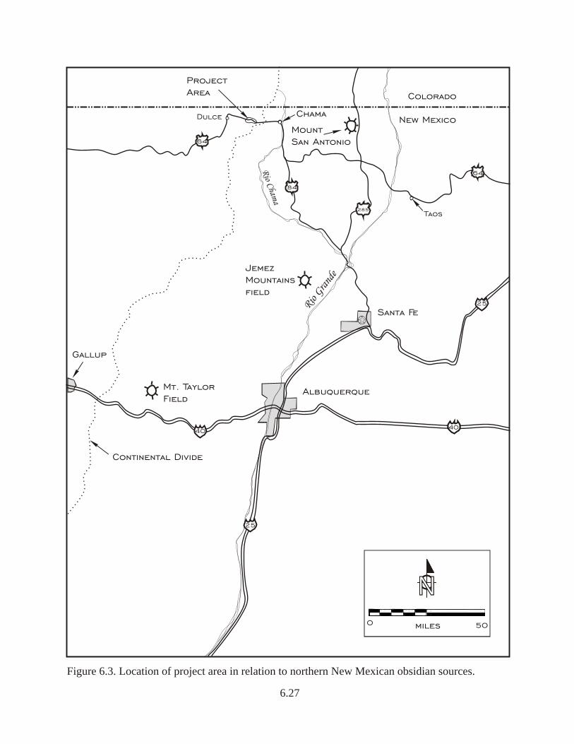
Colorado
New Mexico
Rio Gra
nde
Santa Fe
Continental Divide
Rio Cham
a
Taos
Dulce
MountSan Antonio
Chama
ProjectArea
Mt. Taylor Field
JemezMountainsfield
4040
25
25
64
64
84
285
Albuquerque
0 50miles
NNNN
Figure 6.3. Location of project area in relation to northern New Mexican obsidian sources.
Gallup
6.27
6.28
made use of Jemez Mountain obsidian sources as part of their seasonal round. Findlow and Bolognese(1982:66) describe organized obsidian exchange post-A.D. 1600 as gradually ending.
Based on the procurement model presented by Findlow and Bolognese (1982), the area betweenLumberton and Chama was in a zone of low obsidian distribution relative to the center of activity innorthern New Mexico between the period 5000 B.C. to A.D. 1. This model suggests that the project areawas at the fringe or periphery of primary activity of the region (Rio Grande Valley). During the periodof A.D. 1 to A.D. 500, the project area appeared to be more associated with obsidian procurementsystems in the northwestern portion of New Mexico rather than the Rio Grande Valley area, whichmay correlate spatially with the later Gallina Anasazi area, as defined by Poague et al. (1996:23-25).
But why and how did the Archaic-period occupants use a procurement system that was peripheral toand further from the nearby Mount San Antonio source? A partial answer may lie in the geographyof the area. Passage south towards the Jemez source might have been gained along the Rio Chamaand north via creeks flowing into the Rio Chama. From the project area south to Horse Lake isrelatively mild topography, then south along the waterways access is provided to the Jemez volcanicsources. This route passes near Heron Reservoir and Heron Dam, near the confluence of WillowCreek and Rio Chama. It has been reported (Kelley 2008) that downstream of the dam today areoutcrops of the Burro Canyon Formation and the Morrison Formation, both possible rock types usedby occupants at Site LA 155234. If this route was followed to access the Jemez obsidian, whether bytraders or site inhabitants, then there is the possibility that the Burro Canyon and Morrison formationswere accessed as well, at least for use by occupants of Site LA 155234, where a small sample of theselithic types were recovered.
Approximately 150 miles southwest of the project area is the Chuska Mountains, the source ofWashington Pass chert. A single specimen of Washington Pass chert was recovered at Site LA155234, suggesting that the route from its source was through the San Juan Basin. Thus, exoticmaterials show a cultural connection to the south and west rather than to the east.
6.2.4 Summary
Two hundred four flaked stone and 15 ground stone artifacts were analyzed from excavations at SitesLA 133205, LA 133206, and LA 155234. The majority of artifacts were recovered from Site LA155234 (66 percent), with small assemblage totals (n= 27 and 47) from Sites LA 133205 and LA133206, respectively; therefore, assemblage variability among sites was interpreted with caution.
Site LA 133205 contained two mano fragments, two netherstone fragments, one utilized flake, onebiface, and one notch, as well as debitage. Most of the material was locally derived; obsidian was theonly exotic material (13 percent), with two of the three obsidian artifacts being used as tools. Amobile technology was suggested by the lack of cores and cortex and by debitage characteristics. Foodprocessing and tool manufacture occurred on-site.
6.29
The assemblage at Site LA 133206 consisted of two slab metate fragments, five indeterminatenetherstone fragments, one possible mano blank, three utilized flakes, one utilized core, three bifaces,and one projectile point. This site contained radiocarbon evidence for two components: a LateArchaic period (En Medio phase) and a Protohistoric/Spanish period. There was no evidence in thestone assemblage or spatial distribution for two distinctive technologies. Similar to Site LA 133205,the majority of artifacts at Site LA 133206 were made of locally derived material, with obsidian theonly exotic material (10 percent). Debitage characteristics at this site indicated a mobile technology,but less so than at Site LA 133205. On-site activities include food processing, core reduction, and toolmanufacture.
The largest amount of flaked stone was recovered from Site LA 155234, although it contained thesmallest amount of ground stone (n=3) among the three sites. Flaked stone artifacts at Site LA 155234included 26 tools, five cores (two utilized) and 111 pieces of debitage. Ground stone was composedof one slab metate fragment and two netherstone fragments. Both core reduction and toolmanufactures was represented on-site, and whole flakes occurred in higher frequencies at this site thanat the other two sites. Site LA 155234 had a significantly higher frequency of obsidian (49 percent)than the other two sites, other nonlocal materials and, therefore, less locally derived materials thanthe other sites. Although there were differences among the three sites, the assemblage technology atSite LA 155234 also indicated mobility. With features radiocarbon dated between the late fifteenththrough the mid-seventeenth centuries and three projectile point types typical of the Late Archaicperiod, Site LA 155234 may represent two components; however, there were no distinctivetechnological or spatial differences among artifacts to confirm or refute if there were one or twocomponents to this site.
Lastly, land-use strategies have been posited, using an obsidian procurement distribution model byFindlow and Bolognese (1982) and based on geochemically sourced project obsidian. As all obsidiansubmitted for geochemical sourcing was found to originate from the Jemez Mountain area, siteinhabitants during the Late Archaic period were traveling or trading south toward Jemez Mountainrather than east toward Mount San Antonio and the Rio Grande Valley or southwest to Mount Taylor.Although the Mount San Antonio source was closer then the Jemez Mountain source byapproximately 30 miles and a more important procurement center during the Archaic period, it wasnot used. If Late Archaic inhabitants were procuring Jemez Mountain obsidian, then a new obsidianprocurement distribution model might be postulated, with the Lumberton area inhabitants supportinga different resource (Jemez Mountain) from that of their neighbors to the east and southwest.
6.3 Historic Artifact Analyses: Glass, Ceramics and Metal
by Heather R. Blanton
Glass artifacts/shards were recovered from two sites, LA 133206 and 155234, almost exclusivelyfrom surface contexts. Glass items from the US Highway 64 project provide some insights into accessto commercial food items and ethnicity, but provide a greater level of detail regarding temporalassociations and site occupation(s). As discussed in Chapter 10 and briefly referenced in Chapter 5,
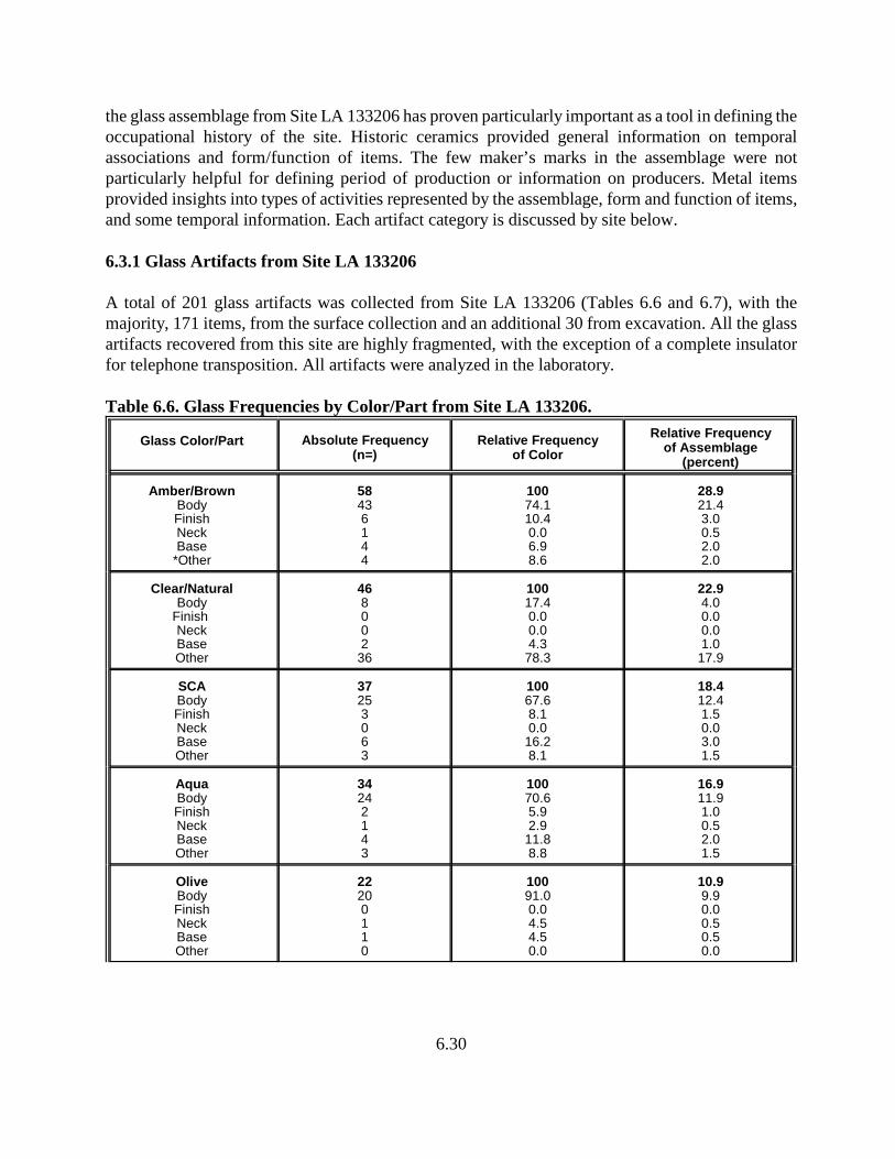
6.30
the glass assemblage from Site LA 133206 has proven particularly important as a tool in defining theoccupational history of the site. Historic ceramics provided general information on temporalassociations and form/function of items. The few maker’s marks in the assemblage were notparticularly helpful for defining period of production or information on producers. Metal itemsprovided insights into types of activities represented by the assemblage, form and function of items,and some temporal information. Each artifact category is discussed by site below.
6.3.1 Glass Artifacts from Site LA 133206
A total of 201 glass artifacts was collected from Site LA 133206 (Tables 6.6 and 6.7), with themajority, 171 items, from the surface collection and an additional 30 from excavation. All the glassartifacts recovered from this site are highly fragmented, with the exception of a complete insulatorfor telephone transposition. All artifacts were analyzed in the laboratory.
Table 6.6. Glass Frequencies by Color/Part from Site LA 133206.
Glass Color/Part Absolute Frequency(n=)
Relative Frequencyof Color
Relative Frequencyof Assemblage
(percent)
Amber/BrownBodyFinishNeckBase
*Other
58436144
10074.110.40.06.98.6
28.921.43.00.52.02.0
Clear/NaturalBody
Finish NeckBaseOther
468002
36
10017.40.00.04.3
78.3
22.94.00.00.01.0
17.9
SCABodyFinishNeckBaseOther
37253063
10067.68.10.0
16.28.1
18.412.41.50.03.01.5
AquaBodyFinishNeckBaseOther
34242143
10070.65.92.9
11.88.8
16.911.91.00.52.01.5
OliveBodyFinishNeckBaseOther
22200110
10091.00.04.54.50.0
10.99.90.00.50.50.0
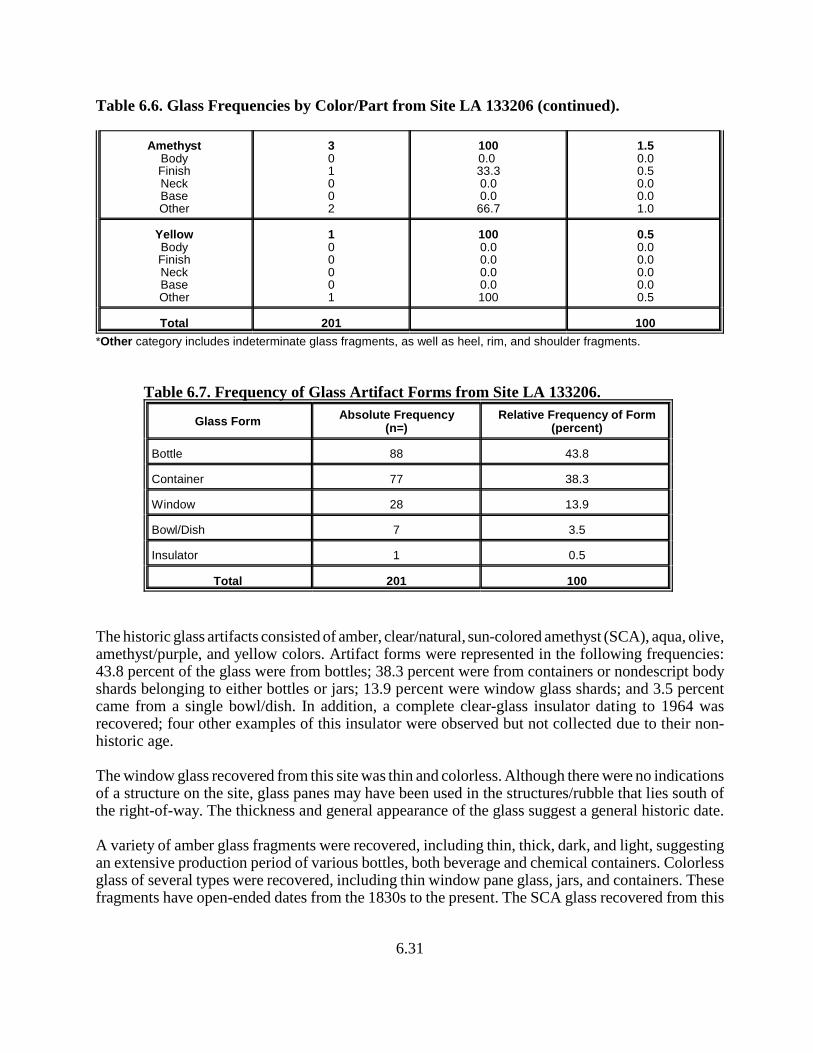
Table 6.6. Glass Frequencies by Color/Part from Site LA 133206 (continued).
6.31
AmethystBodyFinishNeckBaseOther
301002
1000.0 33.30.00.0
66.7
1.50.00.50.00.01.0
YellowBodyFinishNeckBaseOther
100001
1000.00.00.00.0100
0.50.00.00.00.00.5
Total 201 100
*Other category includes indeterminate glass fragments, as well as heel, rim, and shoulder fragments.
Table 6.7. Frequency of Glass Artifact Forms from Site LA 133206.
Glass FormAbsolute Frequency
(n=)Relative Frequency of Form
(percent)
Bottle 88 43.8
Container 77 38.3
Window 28 13.9
Bowl/Dish 7 3.5
Insulator 1 0.5
Total 201 100
The historic glass artifacts consisted of amber, clear/natural, sun-colored amethyst (SCA), aqua, olive,amethyst/purple, and yellow colors. Artifact forms were represented in the following frequencies:43.8 percent of the glass were from bottles; 38.3 percent were from containers or nondescript bodyshards belonging to either bottles or jars; 13.9 percent were window glass shards; and 3.5 percentcame from a single bowl/dish. In addition, a complete clear-glass insulator dating to 1964 wasrecovered; four other examples of this insulator were observed but not collected due to their non-historic age.
The window glass recovered from this site was thin and colorless. Although there were no indicationsof a structure on the site, glass panes may have been used in the structures/rubble that lies south ofthe right-of-way. The thickness and general appearance of the glass suggest a general historic date.
A variety of amber glass fragments were recovered, including thin, thick, dark, and light, suggestingan extensive production period of various bottles, both beverage and chemical containers. Colorlessglass of several types were recovered, including thin window pane glass, jars, and containers. Thesefragments have open-ended dates from the 1830s to the present. The SCA glass recovered from this
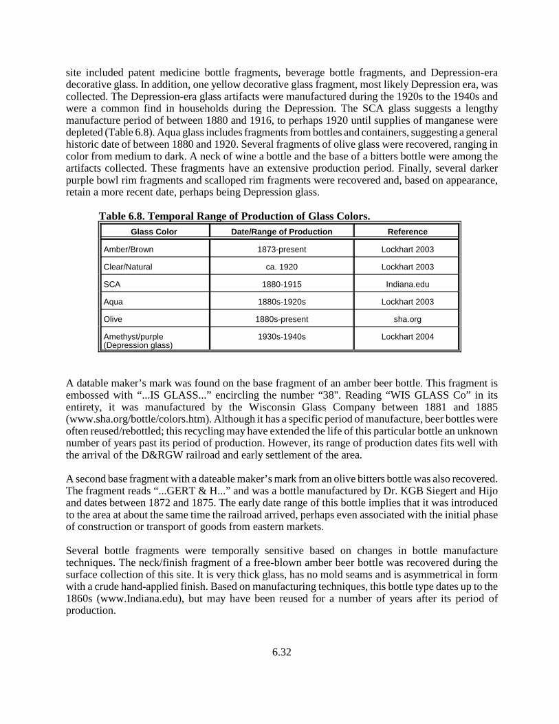
6.32
site included patent medicine bottle fragments, beverage bottle fragments, and Depression-eradecorative glass. In addition, one yellow decorative glass fragment, most likely Depression era, wascollected. The Depression-era glass artifacts were manufactured during the 1920s to the 1940s andwere a common find in households during the Depression. The SCA glass suggests a lengthymanufacture period of between 1880 and 1916, to perhaps 1920 until supplies of manganese weredepleted (Table 6.8). Aqua glass includes fragments from bottles and containers, suggesting a generalhistoric date of between 1880 and 1920. Several fragments of olive glass were recovered, ranging incolor from medium to dark. A neck of wine a bottle and the base of a bitters bottle were among theartifacts collected. These fragments have an extensive production period. Finally, several darkerpurple bowl rim fragments and scalloped rim fragments were recovered and, based on appearance,retain a more recent date, perhaps being Depression glass.
Table 6.8. Temporal Range of Production of Glass Colors.
Glass Color Date/Range of Production Reference
Amber/Brown 1873-present Lockhart 2003
Clear/Natural ca. 1920 Lockhart 2003
SCA 1880-1915 Indiana.edu
Aqua 1880s-1920s Lockhart 2003
Olive 1880s-present sha.org
Amethyst/purple(Depression glass)
1930s-1940s Lockhart 2004
A datable maker’s mark was found on the base fragment of an amber beer bottle. This fragment isembossed with “...IS GLASS...” encircling the number “38". Reading “WIS GLASS Co” in itsentirety, it was manufactured by the Wisconsin Glass Company between 1881 and 1885(www.sha.org/bottle/colors.htm). Although it has a specific period of manufacture, beer bottles wereoften reused/rebottled; this recycling may have extended the life of this particular bottle an unknownnumber of years past its period of production. However, its range of production dates fits well withthe arrival of the D&RGW railroad and early settlement of the area.
A second base fragment with a dateable maker’s mark from an olive bitters bottle was also recovered.The fragment reads “...GERT & H...” and was a bottle manufactured by Dr. KGB Siegert and Hijoand dates between 1872 and 1875. The early date range of this bottle implies that it was introducedto the area at about the same time the railroad arrived, perhaps even associated with the initial phaseof construction or transport of goods from eastern markets.
Several bottle fragments were temporally sensitive based on changes in bottle manufacturetechniques. The neck/finish fragment of a free-blown amber beer bottle was recovered during thesurface collection of this site. It is very thick glass, has no mold seams and is asymmetrical in formwith a crude hand-applied finish. Based on manufacturing techniques, this bottle type dates up to the1860s (www.Indiana.edu), but may have been reused for a number of years after its period ofproduction.
6.33
A second bottle fragment consisting of one side of the neck and finish has been dated by its finishtechnique. This amber bottle fragment has a mold seam that ends at the neck ring and retains asomewhat crude seam where the finish has been applied to the neck with a lipping tool. In addition,horizontal striations are seen in the bottle’s finish. The use of a lipping tool suggests a date of1856–1920s for this bottle (www.sha.org/bottle/index.htm).
The final temporally sensitive glass artifact is datable by its mold seam and finish. This specimen isa neck/finish fragment from a beverage bottle of SCA glass. Its side mold seams end about half aninch from the finish, and the neck has the characteristic subtle hump at the termination of the moldseams indicative of a tooled finish (www.sha.org/bottle/index.htm). Based on the few diagnosticfeatures available from this fragment, this artifact most likely dates to 1865–1915. Based on its color,it probably dates between 1880 and 1915.
Based on the diagnostic glass artifacts, the occupation period of this site centers around the 1880s.The high fragmentation of the artifacts suggests heavy traffic through this area in the past century.Due to its geographic location in the U.S., both technological and deposition lags must be accountedfor in dating this site based solely on its glass artifacts. The range of dates represented by the glassartifacts that are temporally sensitive is 1856 to approximately 1920, perhaps a little later. A secondperiod of occupation/deposition is represented by the Depression glass, suggesting some activity hereperhaps in the 1930s or 1940s. The glass assemblage, however, is well-represented by the period inwhich the Denver & Rio Grande Western (D&RGW) railroad was in use, when Anglo-Euroamerican/Hispanic settlement occurred, and the establishment and early years of the JicarillaIndian Reservation. The assemblage suggests the occupants of the area had access to commercialmarkets, probably through the movement of freight via the railroad. Additionally, with improvedaccess to goods from eastern markets, acquisition strategies and interaction spheres were expanded.Following 1881 and the arrival of the railroad, new market access to goods is reflected in the artifactassemblage from this site. Largely Euroamerican in composition, the glass assemblage does notreadily imply market access by specific ethnic groups (Anglo vs. Hispanic). Lack of definitiveuse/modification by Native Americans prohibits consideration of indigenous groups being responsiblefor any of the assemblage from this site.
6.3.2 Glass Artifacts from Site LA 155234
Only eight glass artifacts were collected from Site LA 155234, five of which were recovered duringsurface collection and the other three from excavation. All of the glass artifacts were fragmented andnon-diagnostic; therefore, few statements concerning their age, function, or ethnicity can be made.They include seven pieces of SCA glass and one piece of orange-colored glass. All were thoroughlyanalyzed in the laboratory.
The low density of glass artifacts, coupled with the single railroad spike on this site, suggests it wasmerely surface trash deposited during the period of construction of the railroad or shortly after. Othernearby disturbance associated with an overhead powerline and its access road could have contributedto the presence of these items. However, the powerline and historic artifacts along it appear to bemuch more recent than the glass recovered from Site LA 155234, suggesting a limited visit to the siteduring the period following the arrival of the railroad. The assemblage is too small to address ethnicassociations.
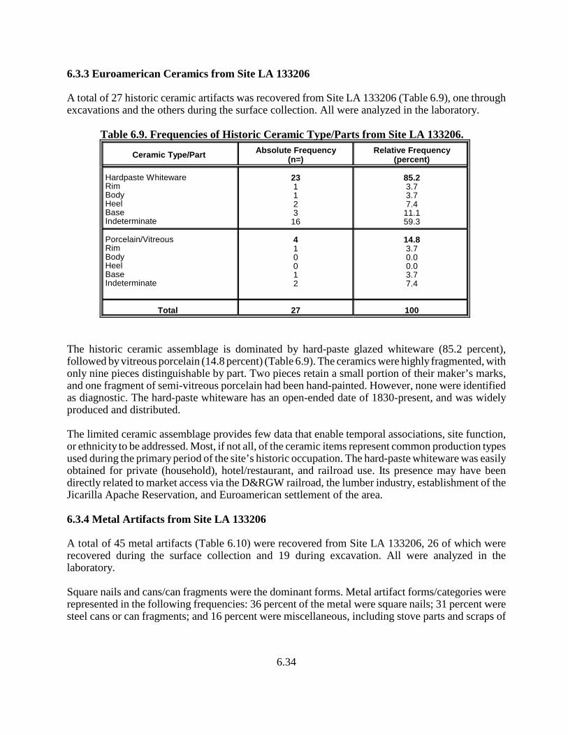
6.34
6.3.3 Euroamerican Ceramics from Site LA 133206
A total of 27 historic ceramic artifacts was recovered from Site LA 133206 (Table 6.9), one throughexcavations and the others during the surface collection. All were analyzed in the laboratory.
Table 6.9. Frequencies of Historic Ceramic Type/Parts from Site LA 133206.
Ceramic Type/PartAbsolute Frequency
(n=)Relative Frequency
(percent)
Hardpaste WhitewareRimBodyHeelBaseIndeterminate
231123
16
85.23.73.77.4
11.159.3
Porcelain/VitreousRimBodyHeelBaseIndeterminate
410012
14.83.70.00.03.77.4
Total 27 100
The historic ceramic assemblage is dominated by hard-paste glazed whiteware (85.2 percent),followed by vitreous porcelain (14.8 percent) (Table 6.9). The ceramics were highly fragmented, withonly nine pieces distinguishable by part. Two pieces retain a small portion of their maker’s marks,and one fragment of semi-vitreous porcelain had been hand-painted. However, none were identifiedas diagnostic. The hard-paste whiteware has an open-ended date of 1830-present, and was widelyproduced and distributed.
The limited ceramic assemblage provides few data that enable temporal associations, site function,or ethnicity to be addressed. Most, if not all, of the ceramic items represent common production typesused during the primary period of the site’s historic occupation. The hard-paste whiteware was easilyobtained for private (household), hotel/restaurant, and railroad use. Its presence may have beendirectly related to market access via the D&RGW railroad, the lumber industry, establishment of theJicarilla Apache Reservation, and Euroamerican settlement of the area.
6.3.4 Metal Artifacts from Site LA 133206
A total of 45 metal artifacts (Table 6.10) were recovered from Site LA 133206, 26 of which wererecovered during the surface collection and 19 during excavation. All were analyzed in thelaboratory.
Square nails and cans/can fragments were the dominant forms. Metal artifact forms/categories wererepresented in the following frequencies: 36 percent of the metal were square nails; 31 percent weresteel cans or can fragments; and 16 percent were miscellaneous, including stove parts and scraps of
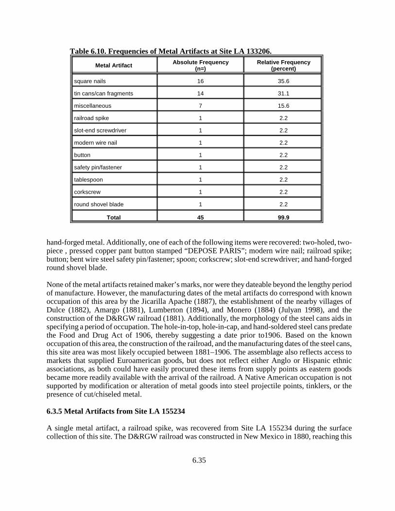
6.35
Table 6.10. Frequencies of Metal Artifacts at Site LA 133206.
Metal ArtifactAbsolute Frequency
(n=)Relative Frequency
(percent)
square nails 16 35.6
tin cans/can fragments 14 31.1
miscellaneous 7 15.6
railroad spike 1 2.2
slot-end screwdriver 1 2.2
modern wire nail 1 2.2
button 1 2.2
safety pin/fastener 1 2.2
tablespoon 1 2.2
corkscrew 1 2.2
round shovel blade 1 2.2
Total 45 99.9
hand-forged metal. Additionally, one of each of the following items were recovered: two-holed, two-piece , pressed copper pant button stamped “DEPOSE PARIS”; modern wire nail; railroad spike;button; bent wire steel safety pin/fastener; spoon; corkscrew; slot-end screwdriver; and hand-forgedround shovel blade.
None of the metal artifacts retained maker’s marks, nor were they dateable beyond the lengthy periodof manufacture. However, the manufacturing dates of the metal artifacts do correspond with knownoccupation of this area by the Jicarilla Apache (1887), the establishment of the nearby villages ofDulce (1882), Amargo (1881), Lumberton (1894), and Monero (1884) (Julyan 1998), and theconstruction of the D&RGW railroad (1881). Additionally, the morphology of the steel cans aids inspecifying a period of occupation. The hole-in-top, hole-in-cap, and hand-soldered steel cans predatethe Food and Drug Act of 1906, thereby suggesting a date prior to1906. Based on the knownoccupation of this area, the construction of the railroad, and the manufacturing dates of the steel cans,this site area was most likely occupied between 1881–1906. The assemblage also reflects access tomarkets that supplied Euroamerican goods, but does not reflect either Anglo or Hispanic ethnicassociations, as both could have easily procured these items from supply points as eastern goodsbecame more readily available with the arrival of the railroad. A Native American occupation is notsupported by modification or alteration of metal goods into steel projectile points, tinklers, or thepresence of cut/chiseled metal.
6.3.5 Metal Artifacts from Site LA 155234
A single metal artifact, a railroad spike, was recovered from Site LA 155234 during the surfacecollection of this site. The D&RGW railroad was constructed in New Mexico in 1880, reaching this
6.36
area by 1881 and completing the San Juan extension of this line, thus suggesting the earliest date forthis item in this area. However, because the railroad spike is associated with an extensive period ofmanufacture, it is of limited use for dating the historic occupation of this site.
6.3.6 Summary of the Historic Artifact Function
South (1977) defined functional groups of historic artifacts, placing them into meaningful categoriesincluding domestic artifact group, architecture group, clothing group, personal group, tool group,hardware group, and a miscellaneous category for other items. He further divided the domestic artifactgroup into food and drink, hygiene, medicine and pharmaceutical, tableware, and other subcategories.The assemblage of historic artifacts from Site LA 133206 is useful in addressing two problemdomains of the research design: Problem Domain 2: Subsistence and Economy; and Problem Domain5: Historic Aboriginal vs. Euroamerican associations. The historic artifact assemblage is indicativeof acquisition strategies (Problem Domain 2) that focused on direct access to Euroamerican goods.As discussed below, the artifact assemblage reflects a strong association with the period following1880, although a few recovered items possess manufacturing/production dates that could exceed 1880by perhaps 10 years. The early range of manufacture/production within the assemblage and the arrivalof the D&RGW railroad in 1881, represents a strong correlation between settlement of the area andaccess to Euroamerican market goods. In assessing the ethnicity of the historic artifact assemblage(Problem Domain 5), the overall assemblage yields strong associations with origins of Angloproduction and market access. Few items exhibit Hispanic associations, although acquisition and useby Hispanic populations cannot be ruled out. Items, such as Hispanic pottery or maker’s marks werenot found within the assemblage. Furthermore, no evidence was found to indicate that NativeAmericans acquired or modified any of the Euroamerican artifacts. The historic artifact assemblagerepresents the following activities as expressed by the functional groups defined by South (1977).
Within the assemblage from Site LA 133206, only items associated with the architecture group arenot represented. Perhaps artifacts that can be assigned to the architecture group were not recovereddue to the use of non-commercial architectural materials, with structures representing vernacular-stylearchitecture, and the absence of historic architecture within the US 64 right-of-way. The recovery ofsquare nails suggests the potential for architecture within the project area; however, no other hardwareor architectural materials were recovered. A good number of items assignable to the domestic groupand tool group were recovered, with a single item representing the clothing group and personal group.All of the artifacts discussed below represent commercially produced items and illustrate access toEuroamerican markets, probably representing depositional events that followed arrival of the railroadto the area. Vernacular or hand-forged items were not recovered, perhaps indicating access tocommercial items was good and commercial items were readily available. Modification of historicitems also was not identified on any historic artifacts, suggesting salvaging of items and reuse wasnot an activity engaged at the site.
Among glass artifacts, bottles and containers represent the domestic group, which can be furtherdivided into subcategories of drink, hygiene, and medicine/pharmaceutical, and bowl/dish fragmentsrepresent the subcategory of tableware. Olive glass is the only color represented that exclusivelyrepresents liquor/wine.
Ceramics most likely represent tableware among the domestic group and items that belong to thepersonal group or medicine/pharmaceutical group, although items such as chamber pots and wash

6.37
basins could be represented. However, most items were hardpaste whiteware serving pieces. ThePorcelain/vitreous category probably represents personal items or pharmaceuticals.
Metal items exhibit the greatest diversity among South’s (1977) defined groups. Nails represent theonly hardware items, dominated by square forms. Cans represent food containers within the domesticgroup; although highly fragmented, the cans exhibit attributes that place production prior to thepassage of the Food and Drug Act of 1906. A single tablespoon also represents the domestic group– tableware subcategory. Within the tool group is a single round shovel blade, a screwdriver, and acorkscrew. A single metal button represents the clothing group, and a safety pin represents thepersonal group.
The absence of reuse or secondary function within the artifact assemblage suggests thatsalvaging/scavenging behavior was not practiced and limits the potential for Native Americaninteraction with Anglo/Hispanic site occupants as documented elsewhere in the Southwest (Purcell1996). Modified items and miscellaneous pieces of cut metal were not discovered. Edge modificationsto glass were not recognized, at least in a meaningful, patterned manner. In short, the historic artifactassemblage does not support a Native American presence after 1880 at Site LA 133206.
7.1
7.0 POLLEN, STARCH, AND MACROFLORAL ANALYSESFOR SITES LA 133205, LA 133206, AND LA 155234
ALONG HIGHWAY 64, NORTHWESTERN NEW MEXICO
by
Linda Scott Cummings and Kathryn Puseman,with assistance from Beth Hickey
Paleo Research Institute
7.1 Introduction
As part of the US 64 Data Recovery project, paleobotanical samples were collected and submittedfor analysis from Sites LA 133205, LA 133206, and LA 155234. Initial evaluations of the sites(Marshall 2001) identified Site LA 133205 as a lithic scatter containing a hearth, assigned to the SanRafael phase (ca. 3500-1800 B.C.), representing a Middle to Late Archaic occupation. Site LA133206 was defined as a multicomponent site that included a prehistoric lithic scatter and a historicartifact scatter and modern corral (Marshall 2001); during data recovery efforts, two hearths werefound. During the survey in 2007, Site LA 155234 was described as a Late Archaic lithic scatter witha thermal feature (Kuru’es et al. 2007); data recovery efforts identified late micaceous graywarepottery and discovered two hearths. Pollen and macrofloral samples were collected from thermalfeatures at these three sites to address subsistence activities.
7.2 Methods
7.2.1 Pollen
A chemical extraction technique based on flotation is the standard preparation technique used forthe removal of the pollen from the large volume of sand, silt, and clay with which they are mixed.This particular process was developed for extraction of pollen from soils where preservation hasbeen less than ideal and pollen density is lower than in bogs or lake sediments.
Hydrochloric acid (10%) was used to remove calcium carbonates present in the soil, after which thesample was screened through 150 micron mesh. The sample was rinsed until neutral by adding water,letting the sample stand for two hours, then pouring off the supernatant. A small quantity of sodiumhexametaphosphate was added to the sample once it reached neutrality, then the beaker again wasfilled with water and allowed to stand for two hours. The sample was again rinsed until neutral,filling the beaker only with water. This step was added to remove clay prior to heavy liquidseparation. At this time the sample was dried, then pulverized. Sodium polytungstate (density 2.1)was used for the flotation process. The sample was mixed with sodium polytungstate and centrifugedat 1500 rpm for 10 minutes to separate organic from inorganic remains. The supernatant containingpollen and organic remains was decanted. Sodium polytungstate again was added to the inorganicfraction to repeat the separation process. The supernatant was decanted into the same tube as the
7.2
supernatant from the first separation. The supernatant was then centrifuged at 1500 rpm for 10minutes to allow any silica remaining to be separated from the organics. Following this, thesupernatant was decanted into a 50 ml conical tube and diluted with distilled water. The sample wascentrifuged at 3000 rpm to concentrate the organic fraction in the bottom of the tube. After rinsingthe pollen-rich organic fraction obtained by this separation, the sample received a short (20-30minute) treatment in hot hydrofluoric acid to remove any remaining inorganic particles. The samplethen was acetolated for 3-5 minutes to remove any extraneous organic matter.
A light microscope was used to count the pollen to a total of 200 pollen grains at a magnification of500×. Pollen preservation in this sample was poor. Comparative reference material collected at theIntermountain Herbarium at Utah State University and the University of Colorado Herbarium wasused to identify the pollen to the family, genus and species level, where possible.
Indeterminate pollen includes pollen grains that are folded, mutilated, and otherwise distortedbeyond recognition. These grains are included in the total pollen count, as they are part of the pollenrecord. The charcoal frequency registers the relationship between pollen and charcoal. The totalnumber of microscopic charcoal fragments was divided by the pollen sum, resulting in a charcoalfrequency that reflected the quantity of charcoal observed, normalized per 100 pollen grains.
Pollen aggregates are normally recorded during identification of the pollen. Aggregates are clumpsof a single type of pollen and may be interpreted to represent pollen dispersal over short distancesor the introduction of portions of the plant represented into an archaeological setting. No aggregateswere observed in these samples. A plus (+) on the pollen diagram indicates that the pollen type wasobserved outside the regular count while scanning the remainder of the microscope slide, which wasdone primarily in search of starches. Pollen diagrams are produced using Tilia, which was developedby Dr. Eric Grimm of the Illinois State Museum. Total pollen concentrations are calculated in Tiliausing the quantity of sample processed in cubic centimeters (cc), the quantity of exotics (spores)added to the sample, the quantity of exotics counted, and the total pollen counted and expressed aspollen per cc of sediment.
Pollen analysis also included identification of starch granules to general categories, if they werepresent. Starch granules are a plant’s mechanism for storing carbohydrates. Starches are found innumerous seeds, as well as in starchy roots and tubers. The primary categories of starches includethe following: with or without visible hila, hilum centric or eccentric, hila patterns (dot, cracked,elongated), and shape of starch (angular, ellipse, circular, eccentric). Some of these starch categoriesare typical of specific plants, while others are more common and tend to occur in many differenttypes of plants.
7.2.2 Macrofloral
The macrofloral samples were floated using a modification of the procedures outlined by Matthews(1979). Each sample was added to approximately 3 gallons of water, then stirred until a strong vortexformed. The floating material (light fraction) was poured through a 150 micron mesh sieve.
7.3
Additional water was added and the process repeated until all floating material was removed fromthe sample (a minimum of five times). The material that remained in the bottom (heavy fraction) waspoured through a 0.5-mm mesh screen. The floated portions were allowed to dry.
The light fractions were weighed, then passed through a series of graduated screens (US StandardSieves with 2-mm, 1-mm, 0.5-mm and 0.25-mm openings) to separate charcoal debris and to initiallysort the remains. The contents of each screen then were examined. Charcoal pieces larger than 2-mm,1-mm, or 0.5-mm in diameter were separated from the rest of the light fraction and the total charcoalweighed. A representative sample of these charcoal pieces was broken to expose a fresh cross sectionand examined under a binocular microscope at a magnification of 70×. The weights of each charcoaltype within the representative sample also were recorded. The material that remained in the 2-mm,1-mm, 0.5mm, and 0.25mm sieves was scanned under a binocular stereo microscope at amagnification of 10×, with some identifications requiring magnifications of up to 70×. The materialthat passed through the 0.25-mm screen was not examined. The heavy fractions were scanned at amagnification of 2× for the presence of botanic remains. Remains from the light and heavy fractionswere recorded as charred and/or uncharred, whole and/or fragments. The term “seed” is used torepresent seeds, achenes, caryopses, and other disseminules. Macrofloral remains are identified usingmanuals (Martin and Barkley 1961; Musil 1963; Schopmeyer 1974) and by comparison with modernand archaeological references.
Samples from archaeological sites commonly contain both charred and uncharred remains. Manyethnobotanists use the basic rule that unless there is a specific reason to believe otherwise, onlycharred remains will be considered prehistoric (Minnis 1981:147). Minnis (1981:147) states that itis “improbable that many prehistoric seeds survive uncharred through common archaeological timespans.” Few seeds live longer than a century, and most live for a much shorter period of time(Harrington 1972; Justice and Bass 1978; Quick 1961). It is presumed that once seeds have died,decomposing organisms act to decay the seeds. Sites in caves, water-logged areas, and in very aridareas, however, can contain uncharred prehistoric remains. Interpretation of uncharred seeds torepresent presence in the prehistoric record is considered on a sample-by-sample basis. Extraordinaryconditions for preservation are required.
Each individual charcoal sample was passed through a graduated screen with a 2 mm opening toseparate the charcoal from the surrounding matrix. The total charcoal was weighed, then arepresentative sample was broken to expose a fresh cross-section and examined under a binocularmicroscope at a magnification of 70×. The weights of each charcoal type within the representativesample were recorded.
7.3 Ethnobotanical Review
It is a commonly accepted practice in archaeological studies to reference ethnographicallydocumented plant uses as indicators of possible or even probable plant uses in prehistoric times. Theethnobotanic literature provides evidence for the exploitation of numerous plants in historic times,both by broad categories and by specific example. Evidence for exploitation from numerous sources
7.4
can suggest a widespread utilization and strengthens the possibility that the same or similar resourceswere used in prehistoric times. Ethnographic sources outside the study area have been consulted topermit a more exhaustive review of potential uses for each plant. Ethnographic sources documentthat with some plants, the historic use was developed and carried from the past. A plant withmedicinal qualities very likely was discovered in prehistoric times and the usage persisted intohistoric times. Loss of knowledge concerning the utilization of plant resources is likely to haveoccurred as cultures moved from subsistence to agricultural economies and/or were introduced toEuropean foods during the historic period. The ethnobotanic literature serves only as a guideindicating that the potential for utilization existed in prehistoric times – not as conclusive evidencethat the resources were used. Pollen and macrofloral remains, when compared with the materialculture (artifacts and features) recovered by the archaeologists, can become indicators of use. Plantsrepresented by pollen, starch, and charred macrofloral remains will be discussed in the followingparagraphs in order to provide an ethnobotanic background for discussing the remains.
7.3.1 Native Plants
7.3.1.1 Cheno-ams
Cheno-ams refer to a group representing the Chenopodiaceae (goosefoot) family and the genusAmaranthus (pigweed). These plants are weedy annuals or perennials, often growing in disturbedareas such as cultivated fields and site vicinities. Cheno-ams, including a variety of plants such asAmaranthus, Atriplex, Chenopodium, Monolepsis, and Suaeda, are noted to have been used for foodand for processing other foods. These plants were exploited for both their greens (cooked aspotherbs) and seeds. The seeds were eaten raw or ground and used to make pinole and/or sometimesmixed with cornmeal to make a variety of mushes and cakes. The seeds usually are noted to havebeen parched prior to grinding. The greens are most tender when young, in the spring, but can beused at any time. The greens can be harvested and cooked either alone or with other foods. Variousparts of the Cheno-am plants are noted to have been gathered from early spring through the fall(Castetter and Bell 1942:61; Curtin 1984:47-71; Kearney and Peebles 1960; Kirk 1975; Robbins etal. 1916; Vestal 1952:24-26).
Chenopodium (Goosefoot, Lamb’s Quarters): Chenopodium (goosefoot) leaves are rich in vitaminC and were eaten to treat stomachaches and to prevent scurvy. Chenopodium also is rich in calciumand vitamin A. Leaf poultices were applied to burns, swellings, and arthritis, and a tea made fromthe whole plant was used to treat diarrhea and toothaches. C. ambrosioides (Mexican tea, Americanwormseed) has been used to expel worms in animals and humans. It also has been used to seasonbeans (Angier 1978:191-193; Krochmal and Krochmal 1973:66-67; Moore 1990:42).
7.3.1.2 Poaceae (Grass Family)
Members of the Poaceae (grass) family widely were used as a food resource by Southwest groups,especially the “cool-season grasses” that utilize winter and spring moisture to promote their growth(Bohrer 1975; Ebeling 1986:464). Cool season grasses mature in early summer and include species
7.5
of bluegrass (Poa), bentgrass (Agrostis), wild rye (Elymus), June grass (Koeleria), wheat grass(Agropyron), quickgrass (Agropyron repens), Indian ricegrass (Oryzopsis hymenoides), Carolinacanary grass (Phalaris caroliniana), six-weeks fescue (Festuca octoflora), bottlebrush squirreltail(Sitanion hystrix), desert needle grass (Stipa speciosa), and little barley grass (Hordeum pusillum).Seeds were eaten raw or parched and ground into a flour that could be combined with other floursand ground meal to make breads and mushes. Young shoots and leaves can be been cooked asgreens. Grass is reported to have been used as a floor covering. Various grasses were used in themanufacture or decoration of pahos (prayer sticks). Grass seeds ripen from spring to fall, dependingon the species, providing a long-term available resource (Chamberlin 1964:372; Colton 1974:338,365; Cushing 1920:219, 253-254; Ebeling 1986; Whiting 1939:65-66).
7.3.1.3 Polygonum (Knotweed, Smartweed)
Polygonum (knotweed, smartweed) are annual or perennial, terrestrial or aquatic herbaceous plants.The seeds can be used whole or parched and ground into a flour. The young leaves were collectedin the spring and used raw, cooked as potherbs, or as a seasoning. Some species, such as P. bistoides,and P. viviparum, have fleshy, starchy roots that are edible raw, boiled, or roasted. Other species(smartweeds) have an acidic juice in the stems and leaves that can cause intestinal disorders if eatenraw in large quantities. Polygonum plants were used to treat swollen and aching joints. P. punctatumplants were steeped in water and the resulting solution was used as a wash for inflamed skin, a garglefor coughs, and as a tea for colds. A P. coccineum leaf tea was used to treat diarrhea, while a roottea was used as a mouthwash for mouth sores. The Navajo used a warm infusion of P. aviculare orP. ramosissimum for stomachaches, and the Zuni used a decoction of P. lapathifolium as an emeticand purgative. Polygonum plants are found in many different habitats that range from moist to dryand sunny to shady thickets, waste places, moist or wet ground, mountains, plains, slopes, hills,roadsides, along steams, or in dry, sandy, rocky soils (Angier 1978:160-161; Harrington 1964:195-201, 1967:195-196; Kearney and Peebles 1960:246; Kirk 1975:56; Moerman 1986:357-359).
7.3.2 Charcoal
Charcoal recovered from archaeological samples most often represents use of that type of wood asfuel; however, several trees and shrubs had utilitarian and medicinal uses as well. The presence ofcharcoal indicates that the trees and shrubs represented were present at the time of occupation. Ifthese resources were present and collected as fuel, it also is possible that they were exploited forother purposes as well. The following paragraphs discuss plants represented only by charcoal in themacrofloral record.
7.3.2.1 Asteraceae (Sunflower Family)
The Asteraceae is the largest family of dicots worldwide. Members of the Asteraceae family wereused in a variety of ways, including as construction materials, tools, crafts, medicines, and as food.Seeds were exploited from numerous members of this group including Artemisia (sagebrush),Balsamorhiza (balsamroot), Helianthus (sunflower), and Madia (tarweed). Most Asteraceae seeds
7.6
ripen in the late summer and fall. The young stems and leaves of Aster (aster), Balsamorhiza, Bidens(Spanish needles, beggarticks), Eclipta (eclipta), Galinsoga (quickweed), Lactuca (wild lettuce),Lygodesmis grandiflora (rush-pink, skeleton plant), Pectis (cinchweed), Petasites (coltsfoot),Solidago (goldenrod), Sonchus (sow-thistle), and Taraxacum (dandelion) can be cooked as greensand/or eaten fresh. Roots of Balsamorhiza, Cirsium (thistle), Helianthus, and Tragopogon(goatsbeard, salsify) can be eaten raw or cooked. A type of chewing gum was made from Encelia(brittlebush), Hieracium (hawkweed), Lygodesmia juncea (skeleton wood) and Tragopogon sap, aswell as Hymenopappus (culleaf) and Lactucapulchella (blue lettuce) roots. Dried flowers and leavesof Achillea (yarrow), Grindelia (gum plant, gumweed), and Thelesperma (Navajo tea, cota,greenthread) were used for making tea. Members of this family also were important medicinalresources. Asteraceae wood was used for making tools, for thatching, and as fuel (Ebeling 1986:529-533; Kirk 1975:132-157, 273-276; Moerman 1998; Moore 1990; Tilford 1997).
7.3.2.2 Juniperus (Juniper)
Juniperus (juniper) berries were a commonly exploited resource for both food and medicine. Juniperberries were an abundant crop and available throughout the year. The berries were eaten fresh, withpiki bread, cooked in stew, boiled, roasted, or used to season meat. Dried berries were stored forwinter use, when they might have been ground into meal and used to make mush, cakes, or abeverage. Fresh berries also were pounded to make a liquid drink. Smith (1974) reports that thenorthern Utes rubbed juniper berries with a mano to separate the seeds from the pulp. The pulp wasthen eaten either fresh or dried and ground on a metate. Juniper seeds were strung together as beads.Juniper was used medicinally by many groups in various ways to cure various ills. The leaves ortwigs are high in vitamins E and C, and were used to make an “all-purpose” medicinal tea,commonly used to treat coughs and colds. A tea made from juniper leaves also was given to Hopiwomen after childbirth (Whiting 1939:62). Juniper trees had utilitarian uses as well. Ashes fromgreen needles were added to water and used as a mordant when dying. The bark, berries, and needleswere used to obtain a brown, orange-tan, or yellow-tan dye. Juniper bark was used for a variety ofpurposes. It was used as a tinder, to line babies’ cradleboards, and to line pits where dried fruits werestored. Juniper bark also was used to weave clothes and sandals. Juniper wood often was used as fueland construction material. Bows and arrows can be made from juniper wood, and juniper pitch wasused to fasten feathers to the arrow shafts. The wood also was used to make prayer sticks (Angell1981:96; Bryan and Young 1978:17, 39; Castetter 1935; Chamberlin 1964:372, 1977:88-90; Robbinset al. 1916:39-41; Vestal 1952:11-12).
7.3.2.3 Pinus (Pine)
All species of Pinus (pine) produce edible nuts, but Pinus edulis (pinyon pine) was one of the mostimportant and widely used pines. Nuts are harvested in the fall or winter, and a bumper crop occursapproximately every seven years. Nuts were eaten raw or roasted by native groups. One method ofroasting pinyon nuts involved shaking nuts and coals in a basket. Whole cones also were collectedand heated over a fire or in ashes to open the scales and release the seeds. Nuts were roasted inpreparation for storage or for being ground into a flour. Ground pinyon nuts were added to corn meal
7.7
or used to thicken soup, make cakes, formed into balls, or to make a paste similar to peanut butter.Pinyon nuts are high in thiamine, riboflavin, niacin, protein, and fat. Pine needles, inner bark, andresin also were used medicinally. The needles are high in vitamin C and can be used to preventscurvy. A medicinal tea was made from pine needles to treat a variety of ills. Pine pitch was chewedas gum, applied to sores and cuts, and used to coat baskets and pottery to make them waterproof.Pinyon pine logs are noted to have been the chief building material for Navajo hogans. Pine wasvalued as firewood because the pitch would readily start the wood burning, even when wet (Angier1978:193-197; Colton 1974:347; Gallagher 1977:37-39; Harrington 1967:323-325; Niethammer1974:47-49; Robbins et al. 1916:41-42; Vestal 1952:12-14; Whiting 1938:22, 63).
7.3.2.4 Pseudotsuga menziesii (Douglas-fir)
Pseudotsuga menziesii (Douglas-fir) trees range throughout forested mountains in the Southwest andare most plentiful in the mixed conifer zone between ponderosa pine (Pinus ponderosa) and spruce(Picea). Fresh Pseudotsuga needles can be steeped in water to make a tea high in vitamin C.Douglas-fir was important in many Hopi, Tewa, and Navajo ceremonies and dances. The Tewa arenoted to have used Douglas-fir branches in almost all their dances. Douglas-fir needles were usedby the Navajo as a ceremonial emetic, and branches were used for the Evilway, Holyway, andNightway ceremonies. The Navajo are reported to have bartered Douglas-fir branches for corn andmeal with the Tewa at Hano. Pseudotsuga menziesii can be found from British Columbia south towest Texas, New Mexico, Arizona, California, and central Mexico (Kirk 1975:19; Lamb 1989:113-114; Petrides and Petrides 1992:52-54; Robbins et al. 1916:42-44; Vestal 1952:14).
7.3.2.5 Quercus (Oak)
Quercus (oak) are deciduous or evergreen shrubs to large trees, and the various species arewidespread throughout the United States. All species of Quercus produce edible acorns, althoughthe presence of tannin results in varying degrees of bitterness. White oak acorns are generally lessbitter than black oak (including red oak) acorns. The acorns of Q. gambelii (Gambel’s oak, RockyMountain white oak) are noted to be the least bitter of all; sometimes they are able to be eaten fresh.Gambel’s oak is the most common oak of the southern Rocky Mountain region. Other species ofacorn are palatable only after the bitter taste has been removed. Acorns are noted to have beenutilized by native peoples in the Southwest. Acorns were gathered, shelled, roasted, and ground intoa meal. The ground meal most often was leached with water in various ways to remove the bittertaste. Wood ashes could be used like lye in the leaching process. The ground meal was used aloneor mixed with cornmeal to make mush, thicken soup, or make breads and cakes. Acorn meal alsocould be mixed with meat or animal fat. Oak wood was used for a variety of utilitarian purposesincluding making bows, arrows, rabbit sticks, digging sticks, clubs, and other utensils. Oak wood isstrong and hard, and it was valued as firewood because a large piece of oak would burn slowly allnight long. Oak bark was the principal source of tanning materials. Oaks in the southwestern UnitedStates can be found in dry soils in canyons and foothills (Elmore 1944:23; Gallagher 1977:113;Harrington 1967:239-241; Kearney and Peebles 1960:216-217; Kirk 1975:104-106; Vines 1960:162;Whiting 1939:72).
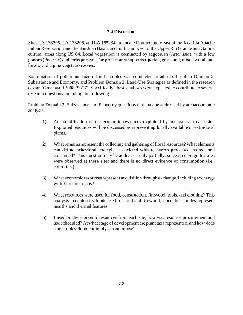
7.8
7.4 Discussion
Sites LA 133205, LA 133206, and LA 155234 are located immediately east of the Jacarilla ApacheIndian Reservation and the San Juan Basin, and north and west of the Upper Rio Grande and Gallinacultural areas along US 64. Local vegetation is dominated by sagebrush (Artemisia), with a fewgrasses (Poaceae) and forbs present. The project area supports riparian, grassland, mixed woodland,forest, and alpine vegetation zones.
Examination of pollen and macrofloral samples was conducted to address Problem Domain 2:Subsistence and Economy, and Problem Domain 3: Land-Use Strategies as defined in the researchdesign (Greenwald 2008:23-27). Specifically, these analyses were expected to contribute to severalresearch questions including the following:
Problem Domain 2: Subsistence and Economy questions that may be addressed by archaeobotanicanalysis.
1) An identification of the economic resources exploited by occupants at each site.Exploited resources will be discussed as representing locally available or extra-localplants.
2) What remains represent the collecting and gathering of floral resources? What elementscan define behavioral strategies associated with resources processed, stored, andconsumed? This question may be addressed only partially, since no storage featureswere observed at these sites and there is no direct evidence of consumption (i.e.,coprolites).
3) What economic resources represent acquisition through exchange, including exchangewith Euroamericans?
4) What resources were used for food, construction, firewood, tools, and clothing? Thisanalysis may identify foods used for food and firewood, since the samples representhearths and thermal features.
5) Based on the economic resources from each site, how was resource procurement anduse scheduled? At what stage of development are plant taxa represented, and how doesstage of development imply season of use?

7.9
Problem Domain 3: Land-Use Strategies includes questions that may be addressed by archaeobotanicanalysis.
1) What is the potential spatial extent or range of the area used by groups associated withthe project area sites?
2) What resource zones and landforms were available to occupants of project sites? Howdid resource availability affect site selection?
3) Using botanical remains and raw materials, what resource zones and landforms wereexploited by project groups?
4) To what extent are site occupants associated with seasonality of use throughexploitation strategies and available resources?
5) What implications can be drawn from the archaeological record that suggest sitelocation is associated with specific subsistence strategies and the exploitation ofspecific resource zones and landforms?
Results from each of these sites is discussed separately as follows.
7.4.1 Site LA 133205
Two cultural features were excavated at Site LA 133205. Feature 1 was a small stain that measured60 cm by 40 cm in diameter and approximately 5 cm in depth, with charcoal and ash. Pollen Sample27 and macrofloral Sample 28 were collected from the fill of this feature (Table 7.1). The pollenrecord was heavily influenced by the presence of microscopic charcoal, which consisted almostentirely of charred Asteraceae (sunflower family) fragments (Figure 7.1, Table 7.2). A moderatequantity of Artemisia pollen dominated the record, which also included Pinus, Quercus, Low-spineAsteraceae, High-spine Asteraceae, Cheno-am, Erigonum, Mammillaria-type, Poaceae, Polemonium,and Shepherdia pollen, representing sagebrush, pine, scrub oak, various members of the sunflowerfamily including the ragweed group and the rabbitbrush/sunflower group, Cheno-ams, wildbuckwheat, ball-type cacti, grasses, Jacob’s ladder, and buffaloberry. The Eriogonum pollen observedin this feature is primarily the type produced by Eriogonum inflatum, which is a plant introduced intoNorth America during the historic era. This indicates the presence of pollen from wild buckwheatgrowing during the historic-to-modern era and probable mixing with prehistoric pollen thataccumulated while this feature filled after its use. The pollen record probably represents vegetationin the vicinity of the feature after the fire subsided. No starches were observed while counting orscanning this sample.
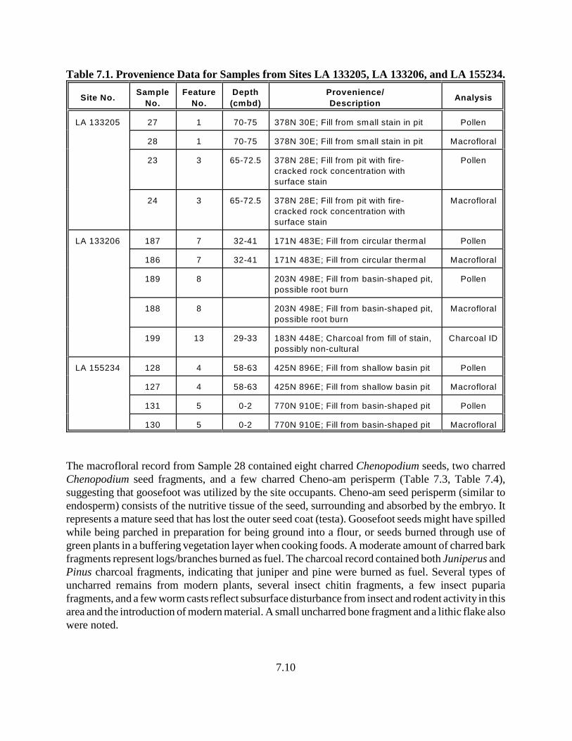
7.10
Table 7.1. Provenience Data for Samples from Sites LA 133205, LA 133206, and LA 155234.
Site No.Sample
No.
Feature
No.
Depth
(cmbd)
Provenience/
DescriptionAnalysis
LA 133205 27 1 70-75 378N 30E; Fill from small stain in pit Pollen
28 1 70-75 378N 30E; Fill from small stain in pit Macrofloral
23 3 65-72.5 378N 28E; Fill from pit with fire-
cracked rock concentration with
surface stain
Pollen
24 3 65-72.5 378N 28E; Fill from pit with fire-
cracked rock concentration with
surface stain
Macrofloral
LA 133206 187 7 32-41 171N 483E; Fill from circular thermal Pollen
186 7 32-41 171N 483E; Fill from circular thermal Macrofloral
189 8 203N 498E; Fill from basin-shaped pit,
possible root burn
Pollen
188 8 203N 498E; Fill from basin-shaped pit,
possible root burn
Macrofloral
199 13 29-33 183N 448E; Charcoal from fill of stain,
possibly non-cultural
Charcoal ID
LA 155234 128 4 58-63 425N 896E; Fill from shallow basin pit Pollen
127 4 58-63 425N 896E; Fill from shallow basin pit Macrofloral
131 5 0-2 770N 910E; Fill from basin-shaped pit Pollen
130 5 0-2 770N 910E; Fill from basin-shaped pit Macrofloral
The macrofloral record from Sample 28 contained eight charred Chenopodium seeds, two charredChenopodium seed fragments, and a few charred Cheno-am perisperm (Table 7.3, Table 7.4),suggesting that goosefoot was utilized by the site occupants. Cheno-am seed perisperm (similar toendosperm) consists of the nutritive tissue of the seed, surrounding and absorbed by the embryo. Itrepresents a mature seed that has lost the outer seed coat (testa). Goosefoot seeds might have spilledwhile being parched in preparation for being ground into a flour, or seeds burned through use ofgreen plants in a buffering vegetation layer when cooking foods. A moderate amount of charred barkfragments represent logs/branches burned as fuel. The charcoal record contained both Juniperus andPinus charcoal fragments, indicating that juniper and pine were burned as fuel. Several types ofuncharred remains from modern plants, several insect chitin fragments, a few insect pupariafragments, and a few worm casts reflect subsurface disturbance from insect and rodent activity in thisarea and the introduction of modern material. A small uncharred bone fragment and a lithic flake alsowere noted.
Figure 7.1. Pollen diagram for Sites LA 133205, LA 133206, and LA 155234. (Note: Site LA 133205 = samples #23 and #27; Site LA 133206 = samples #187 and #189; Site LA 155234 = samples #128 and #131).
7.11
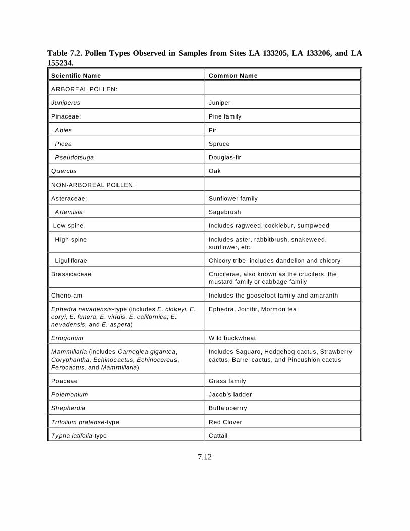
7.12
Table 7.2. Pollen Types Observed in Samples from Sites LA 133205, LA 133206, and LA155234.
Scientific Name Common Name
ARBOREAL POLLEN:
Juniperus Juniper
Pinaceae: Pine family
Abies Fir
Picea Spruce
Pseudotsuga Douglas-fir
Quercus Oak
NON-ARBOREAL POLLEN:
Asteraceae: Sunflower family
Artemisia Sagebrush
Low-spine Includes ragweed, cocklebur, sumpweed
High-spine Includes aster, rabbitbrush, snakeweed,
sunflower, etc.
Liguliflorae Chicory tribe, includes dandelion and chicory
Brassicaceae Cruciferae, also known as the crucifers, the
mustard family or cabbage family
Cheno-am Includes the goosefoot family and amaranth
Ephedra nevadensis-type (includes E. clokeyi, E.
coryi, E. funera, E. viridis, E. californica, E.
nevadensis, and E. aspera)
Ephedra, Jointfir, Mormon tea
Eriogonum W ild buckwheat
Mammillaria (includes Carnegiea gigantea,
Coryphantha, Echinocactus, Echinocereus,
Ferocactus, and Mammillaria)
Includes Saguaro, Hedgehog cactus, Strawberry
cactus, Barrel cactus, and Pincushion cactus
Poaceae Grass family
Polemonium Jacob’s ladder
Shepherdia Buffaloberrry
Trifolium pratense-type Red Clover
Typha latifolia-type Cattail
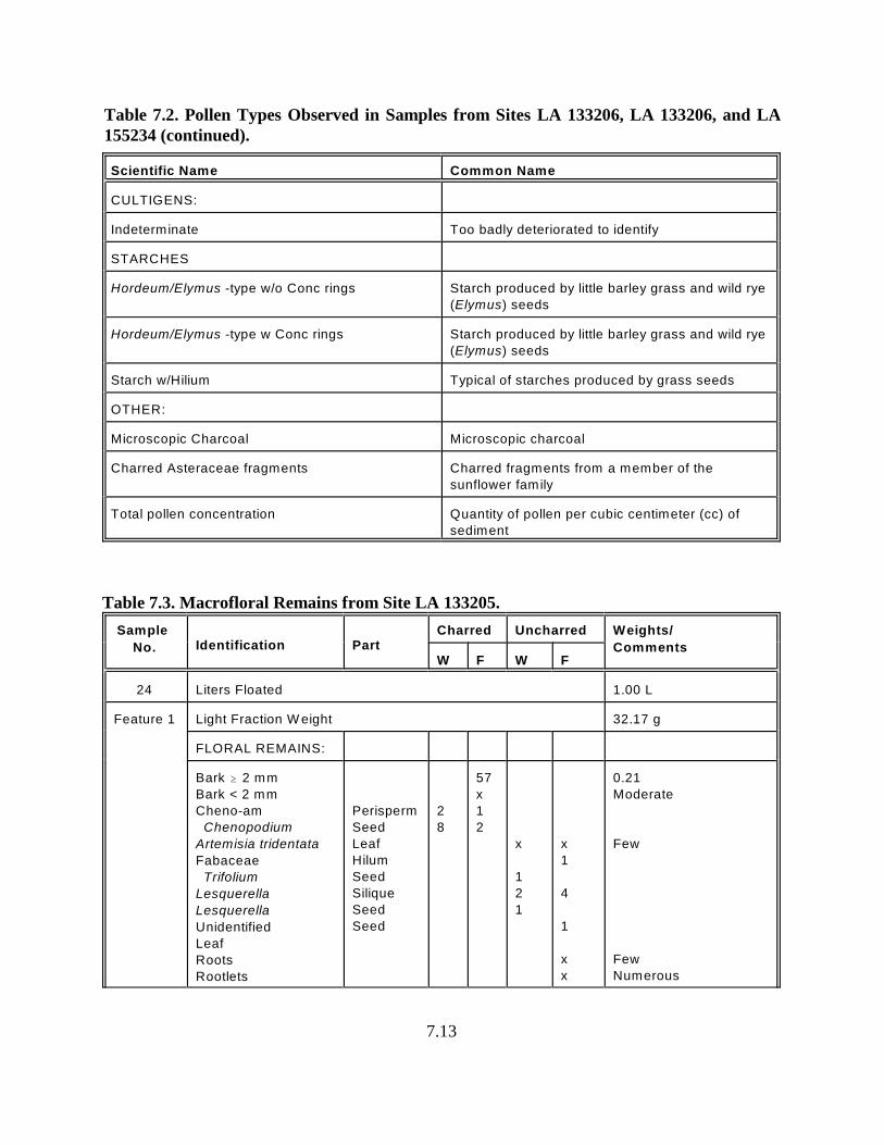
Table 7.2. Pollen Types Observed in Samples from Sites LA 133206, LA 133206, and LA155234 (continued).
Scientific Name Common Name
7.13
CULTIGENS:
Indeterminate Too badly deteriorated to identify
STARCHES
Hordeum/Elymus -type w/o Conc rings Starch produced by little barley grass and wild rye
(Elymus) seeds
Hordeum/Elymus -type w Conc rings Starch produced by little barley grass and wild rye
(Elymus) seeds
Starch w/Hilium Typical of starches produced by grass seeds
OTHER:
Microscopic Charcoal Microscopic charcoal
Charred Asteraceae fragments Charred fragments from a member of the
sunflower family
Total pollen concentration Quantity of pollen per cubic centimeter (cc) of
sediment
Table 7.3. Macrofloral Remains from Site LA 133205.
Sample
No. Identification PartCharred Uncharred Weights/
CommentsW F W F
24 Liters Floated 1.00 L
Feature 1 Light Fraction W eight 32.17 g
FLORAL REMAINS:
Bark $ 2 mm
Bark < 2 mm
Cheno-am
Chenopodium
Artemisia tridentata
Fabaceae
Trifolium
Lesquerella
Lesquerella
Unidentified
Leaf
Roots
Rootlets
Perisperm
Seed
Leaf
Hilum
Seed
Silique
Seed
Seed
2
8
57
x
1
2
x
1
2
1
x
1
4
1
x
x
0.21
Moderate
Few
Few
Numerous
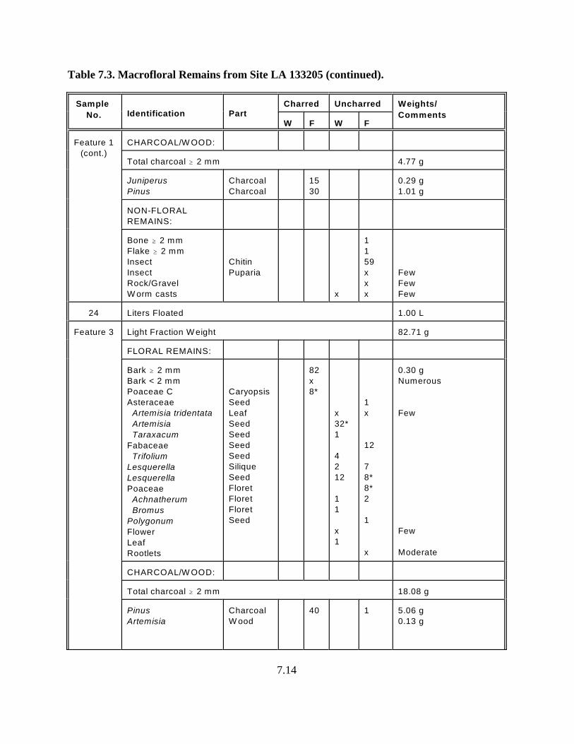
Table 7.3. Macrofloral Remains from Site LA 133205 (continued).
Sample
No. Identification PartCharred Uncharred Weights/
CommentsW F W F
7.14
Feature 1
(cont.)
CHARCOAL/W OOD:
Total charcoal $ 2 mm 4.77 g
Juniperus
Pinus
Charcoal
Charcoal
15
30
0.29 g
1.01 g
NON-FLORAL
REMAINS:
Bone $ 2 mm
Flake $ 2 mm
Insect
Insect
Rock/Gravel
W orm casts
Chitin
Puparia
x
1
1
59
x
x
x
Few
Few
Few
24 Liters Floated 1.00 L
Feature 3 Light Fraction W eight 82.71 g
FLORAL REMAINS:
Bark $ 2 mm
Bark < 2 mm
Poaceae C
Asteraceae
Artemisia tridentata
Artemisia
Taraxacum
Fabaceae
Trifolium
Lesquerella
Lesquerella
Poaceae
Achnatherum
Bromus
Polygonum
Flower
Leaf
Rootlets
Caryopsis
Seed
Leaf
Seed
Seed
Seed
Seed
Silique
Seed
Floret
Floret
Floret
Seed
82
x
8*
x
32*
1
4
2
12
1
1
x
1
1
x
12
7
8*
8*
2
1
x
0.30 g
Numerous
Few
Few
Moderate
CHARCOAL/W OOD:
Total charcoal $ 2 mm 18.08 g
Pinus
Artemisia
Charcoal
W ood
40 1 5.06 g
0.13 g
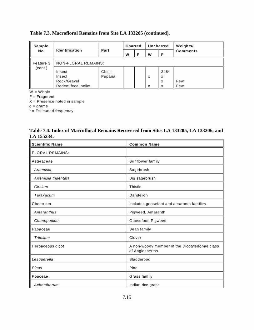
Table 7.3. Macrofloral Remains from Site LA 133205 (continued).
Sample
No. Identification PartCharred Uncharred Weights/
CommentsW F W F
7.15
Feature 3
(cont.)
NON-FLORAL REMAINS:
Insect
Insect
Rock/Gravel
Rodent fecal pellet
Chitin
Puparia x
x
248*
x
x
x
Few
Few
W = W hole
F = Fragment
X = Presence noted in sample
g = grams
* = Estimated frequency
Table 7.4. Index of Macrofloral Remains Recovered from Sites LA 133205, LA 133206, and LA 155234.
Scientific Name Common Name
FLORAL REMAINS:
Asteraceae Sunflower family
Artemisia Sagebrush
Artemisia tridentata Big sagebrush
Cirsium Thistle
Taraxacum Dandelion
Cheno-am Includes goosefoot and amaranth families
Amaranthus Pigweed, Amaranth
Chenopodium Goosefoot, Pigweed
Fabaceae Bean family
Trifolium Clover
Herbaceous dicot A non-woody member of the Dicotyledonae class
of Angiosperms
Lesquerella Bladderpod
Pinus Pine
Poaceae Grass family
Achnatherum Indian rice grass
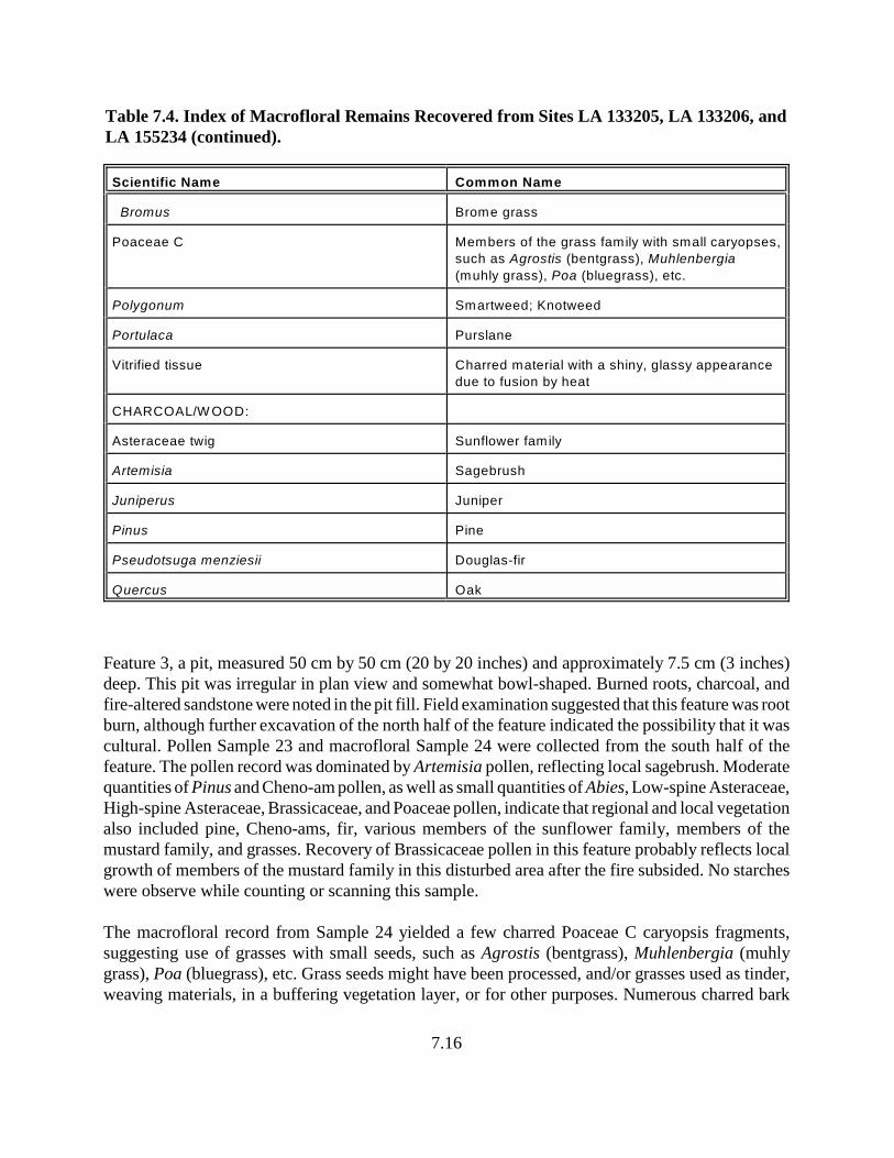
Table 7.4. Index of Macrofloral Remains Recovered from Sites LA 133205, LA 133206, andLA 155234 (continued).
Scientific Name Common Name
7.16
Bromus Brome grass
Poaceae C Members of the grass family with small caryopses,
such as Agrostis (bentgrass), Muhlenbergia
(muhly grass), Poa (bluegrass), etc.
Polygonum Smartweed; Knotweed
Portulaca Purslane
Vitrified tissue Charred material with a shiny, glassy appearance
due to fusion by heat
CHARCOAL/W OOD:
Asteraceae twig Sunflower family
Artemisia Sagebrush
Juniperus Juniper
Pinus Pine
Pseudotsuga menziesii Douglas-fir
Quercus Oak
Feature 3, a pit, measured 50 cm by 50 cm (20 by 20 inches) and approximately 7.5 cm (3 inches)deep. This pit was irregular in plan view and somewhat bowl-shaped. Burned roots, charcoal, andfire-altered sandstone were noted in the pit fill. Field examination suggested that this feature was rootburn, although further excavation of the north half of the feature indicated the possibility that it wascultural. Pollen Sample 23 and macrofloral Sample 24 were collected from the south half of thefeature. The pollen record was dominated by Artemisia pollen, reflecting local sagebrush. Moderatequantities of Pinus and Cheno-am pollen, as well as small quantities of Abies, Low-spine Asteraceae,High-spine Asteraceae, Brassicaceae, and Poaceae pollen, indicate that regional and local vegetationalso included pine, Cheno-ams, fir, various members of the sunflower family, members of themustard family, and grasses. Recovery of Brassicaceae pollen in this feature probably reflects localgrowth of members of the mustard family in this disturbed area after the fire subsided. No starcheswere observe while counting or scanning this sample.
The macrofloral record from Sample 24 yielded a few charred Poaceae C caryopsis fragments,suggesting use of grasses with small seeds, such as Agrostis (bentgrass), Muhlenbergia (muhlygrass), Poa (bluegrass), etc. Grass seeds might have been processed, and/or grasses used as tinder,weaving materials, in a buffering vegetation layer, or for other purposes. Numerous charred bark
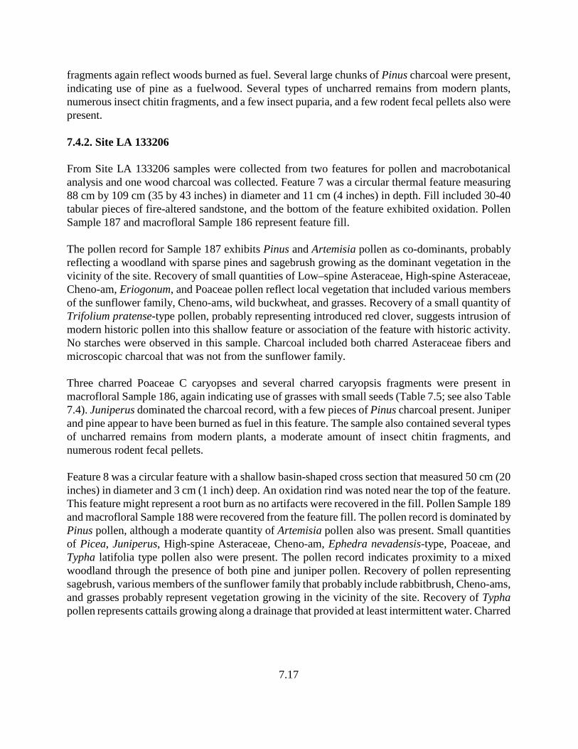
7.17
fragments again reflect woods burned as fuel. Several large chunks of Pinus charcoal were present,indicating use of pine as a fuelwood. Several types of uncharred remains from modern plants,numerous insect chitin fragments, and a few insect puparia, and a few rodent fecal pellets also werepresent.
7.4.2. Site LA 133206
From Site LA 133206 samples were collected from two features for pollen and macrobotanicalanalysis and one wood charcoal was collected. Feature 7 was a circular thermal feature measuring88 cm by 109 cm (35 by 43 inches) in diameter and 11 cm (4 inches) in depth. Fill included 30-40tabular pieces of fire-altered sandstone, and the bottom of the feature exhibited oxidation. PollenSample 187 and macrofloral Sample 186 represent feature fill.
The pollen record for Sample 187 exhibits Pinus and Artemisia pollen as co-dominants, probablyreflecting a woodland with sparse pines and sagebrush growing as the dominant vegetation in thevicinity of the site. Recovery of small quantities of Low–spine Asteraceae, High-spine Asteraceae,Cheno-am, Eriogonum, and Poaceae pollen reflect local vegetation that included various membersof the sunflower family, Cheno-ams, wild buckwheat, and grasses. Recovery of a small quantity ofTrifolium pratense-type pollen, probably representing introduced red clover, suggests intrusion ofmodern historic pollen into this shallow feature or association of the feature with historic activity.No starches were observed in this sample. Charcoal included both charred Asteraceae fibers andmicroscopic charcoal that was not from the sunflower family.
Three charred Poaceae C caryopses and several charred caryopsis fragments were present inmacrofloral Sample 186, again indicating use of grasses with small seeds (Table 7.5; see also Table7.4). Juniperus dominated the charcoal record, with a few pieces of Pinus charcoal present. Juniperand pine appear to have been burned as fuel in this feature. The sample also contained several typesof uncharred remains from modern plants, a moderate amount of insect chitin fragments, andnumerous rodent fecal pellets.
Feature 8 was a circular feature with a shallow basin-shaped cross section that measured 50 cm (20inches) in diameter and 3 cm (1 inch) deep. An oxidation rind was noted near the top of the feature.This feature might represent a root burn as no artifacts were recovered in the fill. Pollen Sample 189and macrofloral Sample 188 were recovered from the feature fill. The pollen record is dominated byPinus pollen, although a moderate quantity of Artemisia pollen also was present. Small quantitiesof Picea, Juniperus, High-spine Asteraceae, Cheno-am, Ephedra nevadensis-type, Poaceae, andTypha latifolia type pollen also were present. The pollen record indicates proximity to a mixedwoodland through the presence of both pine and juniper pollen. Recovery of pollen representingsagebrush, various members of the sunflower family that probably include rabbitbrush, Cheno-ams,and grasses probably represent vegetation growing in the vicinity of the site. Recovery of Typhapollen represents cattails growing along a drainage that provided at least intermittent water. Charred
7.18
Table 7.5. Macrofloral Remains from Site LA 133206.
Sample
No. Identification PartCharred Uncharred Weights/
CommentsW F W F
186 Liters Floated 1.10 L
Feature 7 Light Fraction W eight 14.90 g
FLORAL REMAINS
Poaceae C
Asteraceae
Artemisia tridentata
Artemisia
Cirsium
Chenopodium
Lesquerella
Lesquerella
Polygonum
Portulaca
Unidentified
Rootlets
Caryopsis
Seed
Leaf
Seed
Seed
Seed
Silique
Seed
Seed
Seed
Seed
3 15
10
x
2
1
20
1
x
1
4
2
1
2
x
Moderate
CHARCOAL/W OOD:
Total charcoal $ 2 mm 2.00 g
Juniperus
Pinus
Charcoal
Charcoal
37
3
1.56 g
0.05 g
NON-FLORAL
REMAINS:
Insect
Rock/Gravel
Insect fecal pellet
Chitin
x
x
x
x
Moderate
Few
Numerous
188 Liters Floated 1.00 L
Feature 8 Light Fraction W eight 56.67 g
FLORAL REMAINS:
Bark $ 2 mm
Bark < 2 mm
vitrified tissue
Amaranthus
Artemisia tridentata
Chenopodium
Portulaca
Trifolium
Flower
Roots
Rootlets
Seed
Leaf
Seed
Seed
Seed
5
x
x
1
x
7
8
1
x
x
x
x
x
0.01 g
Few
Few
Few
Few
Few
Moderate
Table 7.5. Macrofloral Remains from Site LA 133206 (continued).
Sample
No. Identification PartCharred Uncharred Weights/
CommentsW F W F
7.19
Feature 8
(cont.)
CHARCOAL/W OOD:
Total charcoal $ 2 mm 17.78 g
Juniperus
Pinus
Pseudotsuga
menziesii
Charcoal
Charcoal
Charcoal
8
31
1
0.30 g
4.71 g
0.06
NON-FLORAL REMAINS:
Insect
Ant
Rock/Gravel
Chitin
2
25
x Few
199 CHARCOAL/W OOD:
Feature
13
Total charcoal $ 2 mm 36.96 g
Pinus Charcoal 15 32.10 g
W = W hole
F = Fragment
X = Presence noted in sample
g = grams
Asteraceae fibers suggest that sagebrush or another woody member of the sunflower family wasburned. This is the only sample that yielded starches. Recovery of Hordeum/Elymus-type starch, bothwith and without obvious concentric rings, indicates either local growth of at least little barley grassand possibly also wild rye or perhaps exploitation of the seeds of these grasses. At least one of theHordeum/Elymus-type starches yielded evidence of cooking. The starch with hilum recovered fromthis feature is typical of many grasses and cannot be identified further.
The macrofloral record for Sample 188 contained a few fragments of charred, vitrified tissue and afew charred bark fragments. Vitrified material has a shiny, glassy appearance due to fusion by heatand might represent charcoal or other charred plant tissue too vitrified for identification. The charcoalrecord was dominated by Pinus, with a few fragments of Juniperus and Pseudotsuga menziesiicharcoal present. Woodland trees exploited for fuel included pine, juniper, and Douglas fir. Inaddition, the sample contained uncharred remains from modern plants, several insect chitinfragments, and ants.
Charcoal Sample 199 was collected from the fill of Feature 13, a stain. During field investigations,this feature was thought to be non-cultural, possibly a root burn. Charcoal Sample 199 consisted of
7.20
large chunks of Pinus branch charcoal, indicating that pine wood was burned. This charcoal does notrepresent burned root wood.
7.4.3 Site LA 155234
Site LA 155234, located at a higher elevation than Sites LA 133205 and LA 133206, may representboth Late Archaic and Protohistoric/Historic occupation. Vegetation is a mixture of sagebrush andpinyon pine. Most of the artifacts were recovered from the surface, although two features weresampled for paleobotanical remains. Pollen and macrofloral samples were examined from Features4 and 5. Feature 4 represents a shallow basin pit. Pollen Sample 128 and macrofloral Sample 127were collected from the feature fill. The pollen signature from Sample 128 includes moderatequantities of Pinus and Artemsia pollen, reflecting local vegetation that appears to have been similarto that of today with scattered pinyon pines and sagebrush. Small quantities of Juniperus, High-spineAsteraceae, Liguliflorae, Cheno-am, Eriogonum, and Poaceae pollen probably reflect the presenceof juniper growing with the pinyon pine and understory plants that included members of thesunflower family such as rabbitbrush, members of the chicory tribe of the sunflower family, Cheno-ams, wild buckwheat, and grasses. Recovery of a small quantity of Typha pollen might reflect eitherwind transport from cattails growing along an intermittent or permanent drainage within 1 or 2 milesof the site or collection, use, and discard of cattails. In either case, recovery of cattail pollendocuments the availability of this wetland resource.
The macrofloral record from Sample 127 yielded Pinus charcoal (Table 7.6; see Table 7.4),indicating that local pine wood was burned as fuel. No other charred remains indicative of foodprocessing activities were recovered. A few uncharred seeds and a moderate amount of rootletsrepresent modern plants in the area. Evidence for bioturbation includes a few insect chitin fragments,an insect puparia, numerous rodent fecal pellets, and a moderate amount of worm casts. A few smallglass fragments reflect Historic occupation of the site.
Feature 5 was an elliptical, basin-shaped pit measuring 70 cm by 40 cm and approximately 2 cmdeep. The fill included ash and clay mixed with coal and charcoal. Little evidence of in-situ burningor oxidation was observed during field efforts. Pollen Sample 131 and macrofloral Sample 130 werecollected from the pit fill. The pollen record was dominated by High-spine Asteraceae pollen,reflecting local growth of members of the sunflower family that include rabbitbrush, sunflower, aster,and others. Moderate quantities of Pinus, Artemisia, Cheno-am, and Eriogonum pollen, as well asa small quantity of Juniperus pollen, reflects local growth of pine, sagebrush, Cheno-ams, wildbuckwheat, and juniper. Recovery of a single grain of Trifolium pratense-type pollen suggestsintrusion of pollen from introduced red clover during the Historic era. Pseudotsuga pollen also wasobserved while scanning the sample, indicating wind transport of pollen from Douglas fir. CharredAsteraceae fibers attest to burning a woody member or members of the sunflower family.
The macrofloral record from Sample 130 contained several charred remains, including a fewherbaceous dicot stem fragments, a charred epidermis fragment, Pinus bark and needle fragments,unidentified bark fragments, and pieces of charred, vitrified tissue. Charred Polygonum seeds suggest
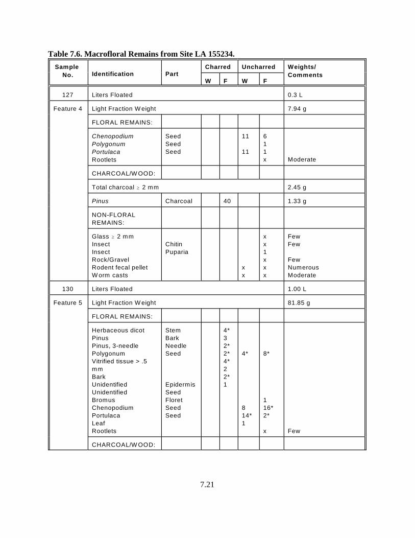
7.21
Table 7.6. Macrofloral Remains from Site LA 155234.
Sample
No. Identification PartCharred Uncharred Weights/
CommentsW F W F
127 Liters Floated 0.3 L
Feature 4 Light Fraction W eight 7.94 g
FLORAL REMAINS:
Chenopodium
Polygonum
Portulaca
Rootlets
Seed
Seed
Seed
11
11
6
1
1
x Moderate
CHARCOAL/W OOD:
Total charcoal $ 2 mm 2.45 g
Pinus Charcoal 40 1.33 g
NON-FLORAL
REMAINS:
Glass $ 2 mm
Insect
Insect
Rock/Gravel
Rodent fecal pellet
W orm casts
Chitin
Puparia
x
x
x
x
1
x
x
x
Few
Few
Few
Numerous
Moderate
130 Liters Floated 1.00 L
Feature 5 Light Fraction W eight 81.85 g
FLORAL REMAINS:
Herbaceous dicot
Pinus
Pinus, 3-needle
Polygonum
Vitrified tissue > .5
mm
Bark
Unidentified
Unidentified
Bromus
Chenopodium
Portulaca
Leaf
Rootlets
Stem
Bark
Needle
Seed
Epidermis
Seed
Floret
Seed
Seed
4*
3
2*
2*
4*
2
2*
1
4*
8
14*
1
8*
1
16*
2*
x Few
CHARCOAL/W OOD:
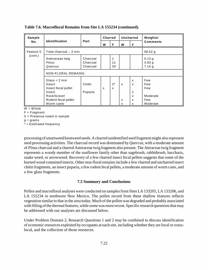
Table 7.6. Macrofloral Remains from Site LA 155234 (continued).
Sample
No. Identification PartCharred Uncharred Weights/
CommentsW F W F
7.22
Feature 5
(cont.)
Total charcoal $ 2 mm 58.52 g
Asteraceae twig
Pinus
Quercus
Charcoal
Charcoal
Charcoal
1
11
33
0.13 g
3.93 g
7.14 g
NON-FLORAL REMAINS:
Glass < 2 mm
Insect
Insect fecal pellet
Insect
Rock/Gravel
Rodent fecal pellet
W orm casts
Chitin
Puparia
x
2*
x
x
x
x
x
x
1
x
x
x
Few
Few
Few
Moderate
Few
Moderate
W = W hole
F = Fragment
X = Presence noted in sample
g = grams
* = Estimated frequency
processing of smartweed/knotweed seeds. A charred unidentified seed fragment might also representseed processing activities. The charcoal record was dominated by Quercus, with a moderate amountof Pinus charcoal and a charred Asteraceae twig fragment also present. The Ateraceae twig fragmentrepresents a woody member of the sunflower family other than sagebrush, rabbitbrush, baccharis,snake weed, or arrowweed. Recovery of a few charred insect fecal pellets suggests that some of theburned wood contained insects. Other non-floral remains include a few charred and uncharred insectchitin fragments, an insect puparia, a few rodent fecal pellets, a moderate amount of worm casts, anda few glass fragments.
7.5 Summary and Conclusions
Pollen and macrofloral analyses were conducted on samples from Sites LA 133205, LA 133206, andLA 155234 in northwest New Mexico. The pollen record from these shallow features reflectsvegetation similar to that in the area today. Much of the pollen was degraded and probably associatedwith filling of the thermal features, while some was more recent. Specific research questions that maybe addressed with our analyses are discussed below.
Under Problem Domain 2, Research Questions 1 and 2 may be combined to discuss identificationof economic resources exploited by occupants at each site, including whether they are local or extra-local, and the collection of those resources.
7.23
Resources that were exploited at Site LA 133205 included local goosefoot, grasses with small seeds,and perhaps members of the mustard family. Occupants of Site LA 133206 used local grasses withsmall seeds that would have included little barley grass (Hordeum), and perhaps cattail. Since thestarch was not identifiable to genus, it is possible that cool season wild rye or wheatgrass, which havelarger seeds, also was exploited. Resources exploited at Site LA 155234 included locally availablesmartweed/knotweed and perhaps cattail.
No evidence was noted in the pollen/starch or macrofloral records of exchange. Recovery of smallglass fragments in the macrofloral samples at Site LA 155234 indicate the presence of historicmaterial (glass fragments) in these areas.
The charcoal record indicates that local juniper and pine were burned as fuel at all three sites. Inaddition, Douglas fir was burned in Feature 8 at Site LA 133206, while a woody member of theAsteraceae family and oak wood were burned in Feature 5 at Site LA 155234. Recovery ofmicroscopic charred Asteraceae fragments supports burning members of the sunflower family,perhaps as tinder. The presence of charcoal indicates that these trees and shrubs would have beenavailable to provide wood for construction materials and tools, as well as edible resources, althoughno direct evidence of their use in these ways was present in the limited amount of samples examined.In addition, recovery of moderate-to-large quantities of Pinus pollen and small quantities ofJuniperus pollen indicate that both pine and juniper grew close enough to the site to have been goodsources of fuel and construction wood.
The macrofloral record indicates that goosefoot, grass, and smartweed/knotweed seeds would havebeen collected in the summer through fall months. Recovery of charred seeds indicates that plantswere mature. The presence of starches that represent exploitation of grass seeds also indicates thatthese seeds were mature and collected during the summer and/or fall when they are available.Because these seeds may be stored before use, it does not necessarily mean that the seeds wereprocessed immediately upon collection.
The pollen, starch and macrofloral records indicate that the local landscape included both uplandsand wetlands, both of which were used by occupants of these sites in general and Sites LA 133206and LA 155234 in particular. Recovery of charcoal indicates that wood from trees found inwoodland/forested areas were collected and burned as fuel. Evidence for use of plants found inriparian habitats is confined to the recovery of Typha pollen at Sites LA 133206 and LA 155234. Thenature of macrofloral remains is that they represent parts of plants (seeds) that are available in thesummer and fall months. Seeds are easily stored for use throughout the year. Pollen is distributed onthe wind throughout the growing season, with each genus contributing during the part of the growingseason that it pollinates. The pollen record is a mixture of pollen from many seasons and usuallyseveral years, making interpretation of season of use very difficult unless very specific samples werecollected and analyzed. The pollen, starch and macrofloral records indicate that people who usedthese sites exploited the local pinyon/juniper woodland, which might have been rather sparse, andplants in the understory associated with the sparse woodland. In addition, wetlands were availableand probably exploited. Evidence for subsistence at these sites appears to represent a generalized

7.24
adaptation to this widespread set of landforms and resources that are common in the Southwest. Noevidence was found within the pollen, starch and macrofloral analysis to show that site location wasassociated with specific subsistence strategies or the exploitation of specific resource zones andlandforms.
8.1
8.0 FAUNAL ANALYSIS FOR THE US 64 DATA RECOVERY PROJECT
by Kathy Roler Durand, Ph.D.Eastern New Mexico University
A total of 24 specimens, represented by 30 fragments, were present in the assemblage from thisproject. The bones came from three sites: LA 133205 (with 22 fragments representing 17specimens), LA 133206 (with 4 specimens), and LA 155234 (with four fragments representing threespecimens). In general, most of the remains were indeterminate medium and large mammal bonefragments, although fragments from two cottontail elements were present, as well as two Bos/bisonfragments and one fragment of an artiodactyla foot bone. The bones are described below, anditemized in Tables 8.1-8.3.
8.1 Methods Used
The bones were identified using the comparative zooarchaeology collection at Eastern New MexicoUniversity (ENMU). All bones were examined for cut and gnaw marks using a 10× hand lens andstrong light. The Coding Key used during this analysis and the Excel file of the original datacollection sheets with all data is included as Appendix E. In cases for which the taxa could not bedetermined, size categories were utilized. The size categories used for this report include MediumMammals (canid/bobcat in size); Medium-Large Mammals (at least canid/bobcat in size andpossibly larger); Large Mammals (bones from mammals that are at least the size of artiodactyla);and Very Large Mammals (bones that are from mammals that are Bos or bison in size). As manyskeletal elements of cattle (Bos) and bison are indistinguishable, the combined category of Bos/bisonis used below for two fragments of elements that could not be distinguished between these taxa.Finally, in the description and the tables below, there are often more fragments listed thanspecimens. Here, fragment is used to refer to any broken piece of bone, while specimen is used torefer to a skeletal element or a fragment of an element that may be composed of several refitfragments. Thus, in several cases, two or three fragments were refit from the same bag that actuallywere all part of the same element.
8.1.1 Site LA 133205
This site had the majority of faunal remains from the assemblage (Table 8.1). All bones from thesite were typical dietary remains. Although no cutmarks were observed on these bones, 11 of themwere weathered such that the external surface of the bone was not intact enough for cutmarks to bedetected.
Level 1 contained the single cottontail remain from this site. This was a cranial fragment andincluded the frontal and squamosal portions of the skull. This bone was from Feature 3, which wasan area of pit with staining and burned sandstone (fire-cracked rock) and a definite cultural feature.The cottontail skull fragment was unburned and did not display any cutmarks; nonetheless, itsoccurrence in this feature suggests it may have been part of the diet of the site’s inhabitants.
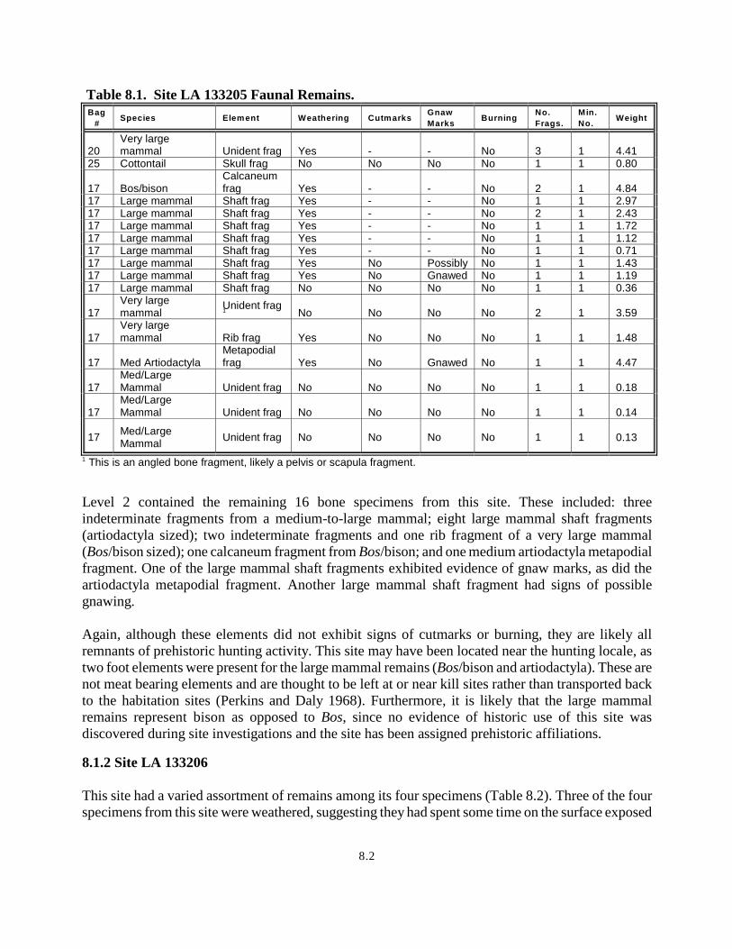
8.2
Table 8.1. Site LA 133205 Faunal Remains.Bag
#Species Element Weathering Cutmarks
Gnaw
MarksBurning
No.
Frags.
Min.
No.Weight
20Very largemammal Unident frag Yes - - No 3 1 4.41
25 Cottontail Skull frag No No No No 1 1 0.80
17 Bos/bisonCalcaneumfrag Yes - - No 2 1 4.84
17 Large mammal Shaft frag Yes - - No 1 1 2.9717 Large mammal Shaft frag Yes - - No 2 1 2.4317 Large mammal Shaft frag Yes - - No 1 1 1.7217 Large mammal Shaft frag Yes - - No 1 1 1.1217 Large mammal Shaft frag Yes - - No 1 1 0.7117 Large mammal Shaft frag Yes No Possibly No 1 1 1.4317 Large mammal Shaft frag Yes No Gnawed No 1 1 1.1917 Large mammal Shaft frag No No No No 1 1 0.36
17Very largemammal
Unident frag1 No No No No 2 1 3.59
17Very largemammal Rib frag Yes No No No 1 1 1.48
17 Med ArtiodactylaMetapodialfrag Yes No Gnawed No 1 1 4.47
17Med/LargeMammal Unident frag No No No No 1 1 0.18
17Med/LargeMammal Unident frag No No No No 1 1 0.14
17Med/LargeMammal
Unident frag No No No No 1 1 0.13
This is an angled bone fragment, likely a pelvis or scapula fragment.1
Level 2 contained the remaining 16 bone specimens from this site. These included: threeindeterminate fragments from a medium-to-large mammal; eight large mammal shaft fragments(artiodactyla sized); two indeterminate fragments and one rib fragment of a very large mammal(Bos/bison sized); one calcaneum fragment from Bos/bison; and one medium artiodactyla metapodialfragment. One of the large mammal shaft fragments exhibited evidence of gnaw marks, as did theartiodactyla metapodial fragment. Another large mammal shaft fragment had signs of possiblegnawing. Again, although these elements did not exhibit signs of cutmarks or burning, they are likely allremnants of prehistoric hunting activity. This site may have been located near the hunting locale, astwo foot elements were present for the large mammal remains (Bos/bison and artiodactyla). These arenot meat bearing elements and are thought to be left at or near kill sites rather than transported backto the habitation sites (Perkins and Daly 1968). Furthermore, it is likely that the large mammalremains represent bison as opposed to Bos, since no evidence of historic use of this site wasdiscovered during site investigations and the site has been assigned prehistoric affiliations.
8.1.2 Site LA 133206
This site had a varied assortment of remains among its four specimens (Table 8.2). Three of the fourspecimens from this site were weathered, suggesting they had spent some time on the surface exposed
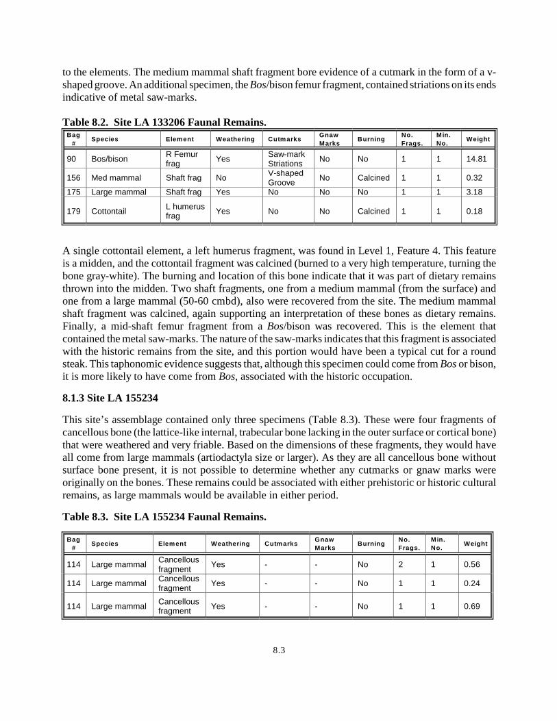
8.3
to the elements. The medium mammal shaft fragment bore evidence of a cutmark in the form of a v-shaped groove. An additional specimen, the Bos/bison femur fragment, contained striations on its endsindicative of metal saw-marks.
Table 8.2. Site LA 133206 Faunal Remains.Bag
#Species Element Weathering Cutmarks
Gnaw
MarksBurning
No.
Frags.
Min.
No.Weight
90 Bos/bisonR Femurfrag
YesSaw-markStriations
No No 1 1 14.81
156 Med mammal Shaft frag NoV-shapedGroove
No Calcined 1 1 0.32
175 Large mammal Shaft frag Yes No No No 1 1 3.18
179 CottontailL humerusfrag
Yes No No Calcined 1 1 0.18
A single cottontail element, a left humerus fragment, was found in Level 1, Feature 4. This featureis a midden, and the cottontail fragment was calcined (burned to a very high temperature, turning thebone gray-white). The burning and location of this bone indicate that it was part of dietary remainsthrown into the midden. Two shaft fragments, one from a medium mammal (from the surface) andone from a large mammal (50-60 cmbd), also were recovered from the site. The medium mammalshaft fragment was calcined, again supporting an interpretation of these bones as dietary remains.Finally, a mid-shaft femur fragment from a Bos/bison was recovered. This is the element thatcontained the metal saw-marks. The nature of the saw-marks indicates that this fragment is associatedwith the historic remains from the site, and this portion would have been a typical cut for a roundsteak. This taphonomic evidence suggests that, although this specimen could come from Bos or bison,it is more likely to have come from Bos, associated with the historic occupation.
8.1.3 Site LA 155234
This site’s assemblage contained only three specimens (Table 8.3). These were four fragments ofcancellous bone (the lattice-like internal, trabecular bone lacking in the outer surface or cortical bone)that were weathered and very friable. Based on the dimensions of these fragments, they would haveall come from large mammals (artiodactyla size or larger). As they are all cancellous bone withoutsurface bone present, it is not possible to determine whether any cutmarks or gnaw marks wereoriginally on the bones. These remains could be associated with either prehistoric or historic culturalremains, as large mammals would be available in either period.
Table 8.3. Site LA 155234 Faunal Remains.
Bag
#Species Element Weathering Cutmarks
Gnaw
MarksBurning
No.
Frags.
Min.
No.Weight
114 Large mammalCancellousfragment
Yes - - No 2 1 0.56
114 Large mammalCancellousfragment
Yes - - No 1 1 0.24
114 Large mammalCancellousfragment
Yes - - No 1 1 0.69

8.4
8.2 Summary
The faunal remains from the US 64 Data Recovery Project all appear to have been dietary remains.There was no evidence of articulated elements (suggesting natural death at a site), nor was thereextensive evidence of gnaw marks, as might be expected if they were accumulated by carnivores.Therefore, it is considered more likely that humans created these assemblages rather than naturalforces. Site LA 133206 has the strongest evidence that humans created the faunal assemblage, ascutmarks and burning were present on two of the four specimens. The assemblages from Sites LA133205 and LA 133206 were recovered from contexts that strongly suggest a direct association withthe archaeological/historic occupation of these sites. Such an association is not supported as well atSite LA 155234, although no evidence was found to discount it.
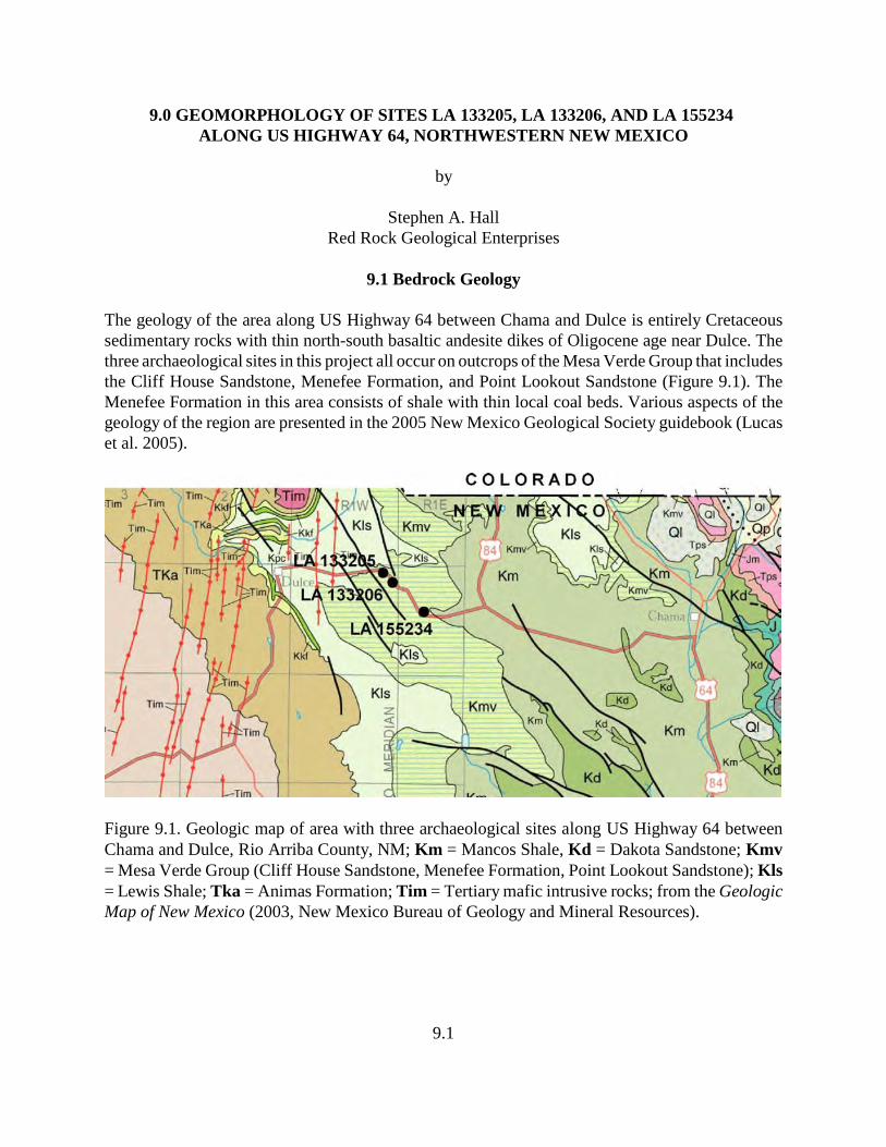
9.1
9.0 GEOMORPHOLOGY OF SITES LA 133205, LA 133206, AND LA 155234 ALONG US HIGHWAY 64, NORTHWESTERN NEW MEXICO
by
Stephen A. HallRed Rock Geological Enterprises
9.1 Bedrock Geology
The geology of the area along US Highway 64 between Chama and Dulce is entirely Cretaceoussedimentary rocks with thin north-south basaltic andesite dikes of Oligocene age near Dulce. Thethree archaeological sites in this project all occur on outcrops of the Mesa Verde Group that includesthe Cliff House Sandstone, Menefee Formation, and Point Lookout Sandstone (Figure 9.1). TheMenefee Formation in this area consists of shale with thin local coal beds. Various aspects of thegeology of the region are presented in the 2005 New Mexico Geological Society guidebook (Lucaset al. 2005).
Figure 9.1. Geologic map of area with three archaeological sites along US Highway 64 betweenChama and Dulce, Rio Arriba County, NM; Km = Mancos Shale, Kd = Dakota Sandstone; Kmv= Mesa Verde Group (Cliff House Sandstone, Menefee Formation, Point Lookout Sandstone); Kls= Lewis Shale; Tka = Animas Formation; Tim = Tertiary mafic intrusive rocks; from the GeologicMap of New Mexico (2003, New Mexico Bureau of Geology and Mineral Resources).
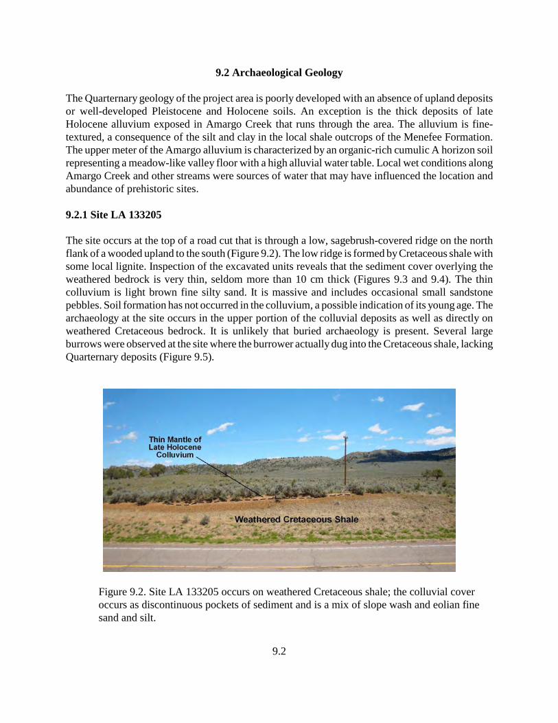
9.2
9.2 Archaeological Geology
The Quarternary geology of the project area is poorly developed with an absence of upland depositsor well-developed Pleistocene and Holocene soils. An exception is the thick deposits of lateHolocene alluvium exposed in Amargo Creek that runs through the area. The alluvium is fine-textured, a consequence of the silt and clay in the local shale outcrops of the Menefee Formation.The upper meter of the Amargo alluvium is characterized by an organic-rich cumulic A horizon soilrepresenting a meadow-like valley floor with a high alluvial water table. Local wet conditions alongAmargo Creek and other streams were sources of water that may have influenced the location andabundance of prehistoric sites.
9.2.1 Site LA 133205
The site occurs at the top of a road cut that is through a low, sagebrush-covered ridge on the northflank of a wooded upland to the south (Figure 9.2). The low ridge is formed by Cretaceous shale withsome local lignite. Inspection of the excavated units reveals that the sediment cover overlying theweathered bedrock is very thin, seldom more than 10 cm thick (Figures 9.3 and 9.4). The thincolluvium is light brown fine silty sand. It is massive and includes occasional small sandstonepebbles. Soil formation has not occurred in the colluvium, a possible indication of its young age. Thearchaeology at the site occurs in the upper portion of the colluvial deposits as well as directly onweathered Cretaceous bedrock. It is unlikely that buried archaeology is present. Several largeburrows were observed at the site where the burrower actually dug into the Cretaceous shale, lackingQuarternary deposits (Figure 9.5).
Figure 9.2. Site LA 133205 occurs on weathered Cretaceous shale; the colluvial coveroccurs as discontinuous pockets of sediment and is a mix of slope wash and eolian finesand and silt.
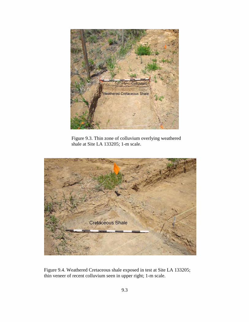
9.3
Figure 9.3. Thin zone of colluvium overlying weatheredshale at Site LA 133205; 1-m scale.
Figure 9.4. Weathered Cretaceous shale exposed in test at Site LA 133205;thin veneer of recent colluvium seen in upper right; 1-m scale.
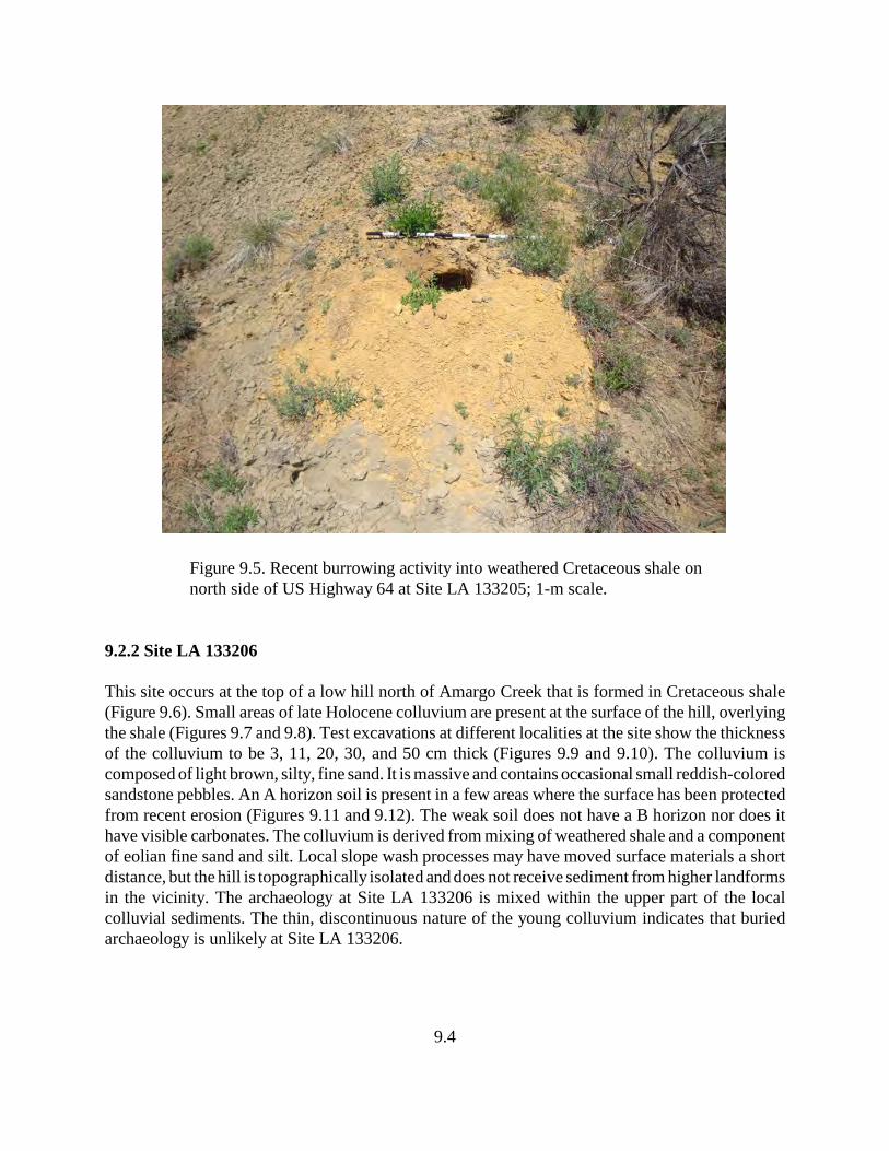
9.4
Figure 9.5. Recent burrowing activity into weathered Cretaceous shale onnorth side of US Highway 64 at Site LA 133205; 1-m scale.
9.2.2 Site LA 133206
This site occurs at the top of a low hill north of Amargo Creek that is formed in Cretaceous shale(Figure 9.6). Small areas of late Holocene colluvium are present at the surface of the hill, overlyingthe shale (Figures 9.7 and 9.8). Test excavations at different localities at the site show the thicknessof the colluvium to be 3, 11, 20, 30, and 50 cm thick (Figures 9.9 and 9.10). The colluvium iscomposed of light brown, silty, fine sand. It is massive and contains occasional small reddish-coloredsandstone pebbles. An A horizon soil is present in a few areas where the surface has been protectedfrom recent erosion (Figures 9.11 and 9.12). The weak soil does not have a B horizon nor does ithave visible carbonates. The colluvium is derived from mixing of weathered shale and a componentof eolian fine sand and silt. Local slope wash processes may have moved surface materials a shortdistance, but the hill is topographically isolated and does not receive sediment from higher landformsin the vicinity. The archaeology at Site LA 133206 is mixed within the upper part of the localcolluvial sediments. The thin, discontinuous nature of the young colluvium indicates that buriedarchaeology is unlikely at Site LA 133206.
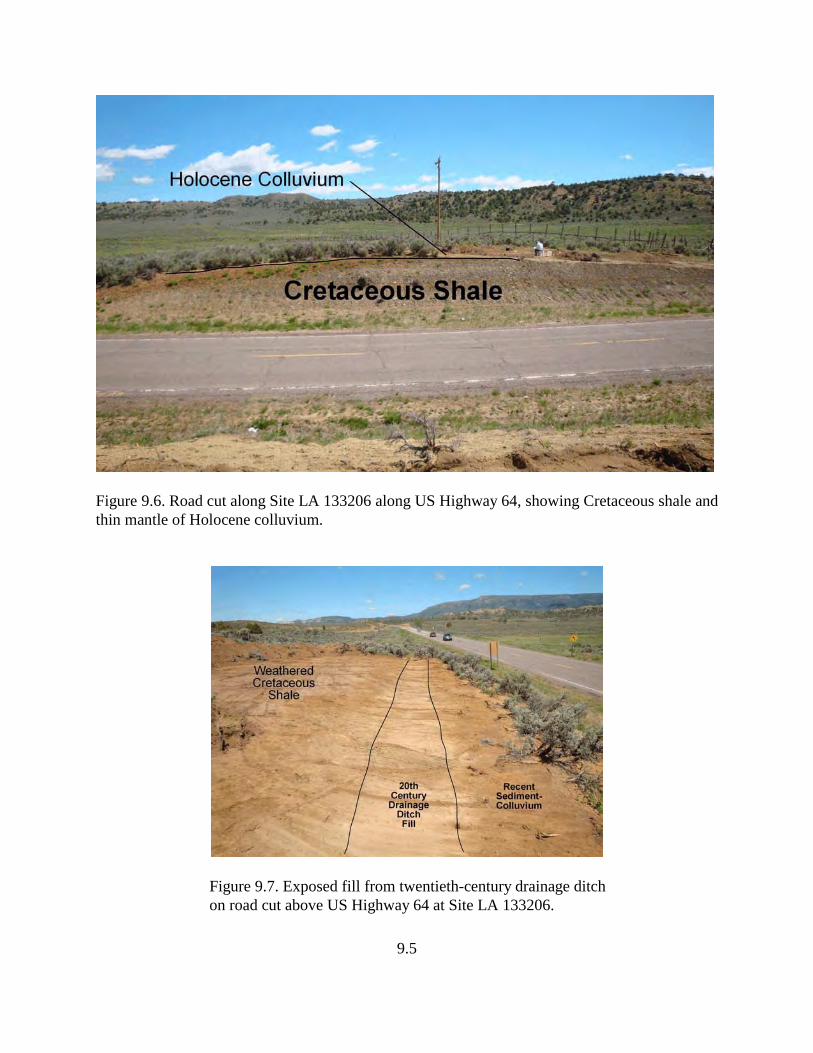
9.5
Figure 9.6. Road cut along Site LA 133206 along US Highway 64, showing Cretaceous shale andthin mantle of Holocene colluvium.
Figure 9.7. Exposed fill from twentieth-century drainage ditchon road cut above US Highway 64 at Site LA 133206.
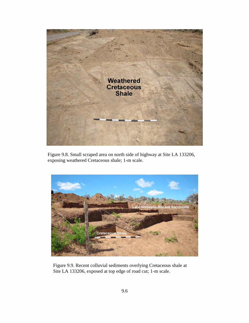
9.6
Figure 9.8. Small scraped area on north side of highway at Site LA 133206,exposing weathered Cretaceous shale; 1-m scale.
Figure 9.9. Recent colluvial sediments overlying Cretaceous shale atSite LA 133206, exposed at top edge of road cut; 1-m scale.
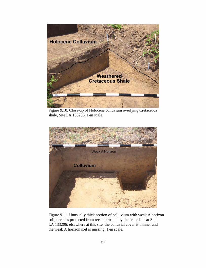
9.7
Figure 9.10. Close-up of Holocene colluvium overlying Cretaceousshale, Site LA 133206, 1-m scale.
Figure 9.11. Unusually thick section of colluvium with weak A horizonsoil, perhaps protected from recent erosion by the fence line at SiteLA 133206; elsewhere at this site, the colluvial cover is thinner andthe weak A horizon soil is missing; 1-m scale.
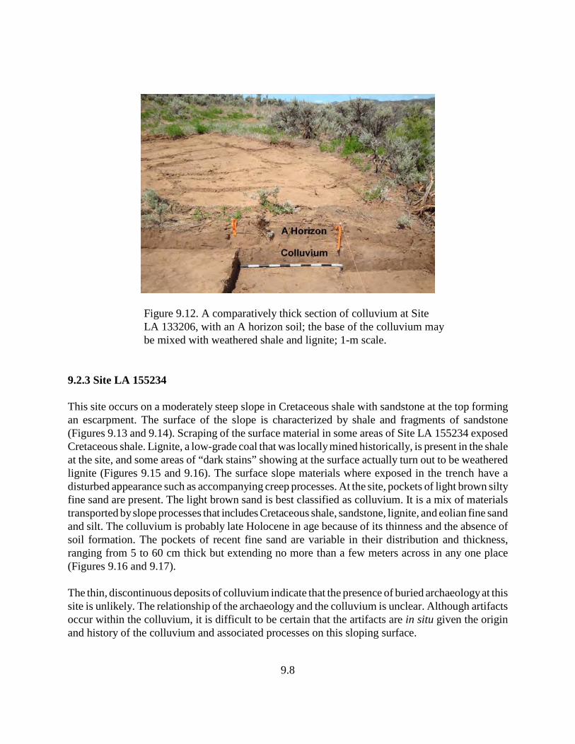
9.8
Figure 9.12. A comparatively thick section of colluvium at SiteLA 133206, with an A horizon soil; the base of the colluvium maybe mixed with weathered shale and lignite; 1-m scale.
9.2.3 Site LA 155234
This site occurs on a moderately steep slope in Cretaceous shale with sandstone at the top formingan escarpment. The surface of the slope is characterized by shale and fragments of sandstone(Figures 9.13 and 9.14). Scraping of the surface material in some areas of Site LA 155234 exposedCretaceous shale. Lignite, a low-grade coal that was locally mined historically, is present in the shaleat the site, and some areas of “dark stains” showing at the surface actually turn out to be weatheredlignite (Figures 9.15 and 9.16). The surface slope materials where exposed in the trench have adisturbed appearance such as accompanying creep processes. At the site, pockets of light brown siltyfine sand are present. The light brown sand is best classified as colluvium. It is a mix of materialstransported by slope processes that includes Cretaceous shale, sandstone, lignite, and eolian fine sandand silt. The colluvium is probably late Holocene in age because of its thinness and the absence ofsoil formation. The pockets of recent fine sand are variable in their distribution and thickness,ranging from 5 to 60 cm thick but extending no more than a few meters across in any one place(Figures 9.16 and 9.17).
The thin, discontinuous deposits of colluvium indicate that the presence of buried archaeology at thissite is unlikely. The relationship of the archaeology and the colluvium is unclear. Although artifactsoccur within the colluvium, it is difficult to be certain that the artifacts are in situ given the originand history of the colluvium and associated processes on this sloping surface.
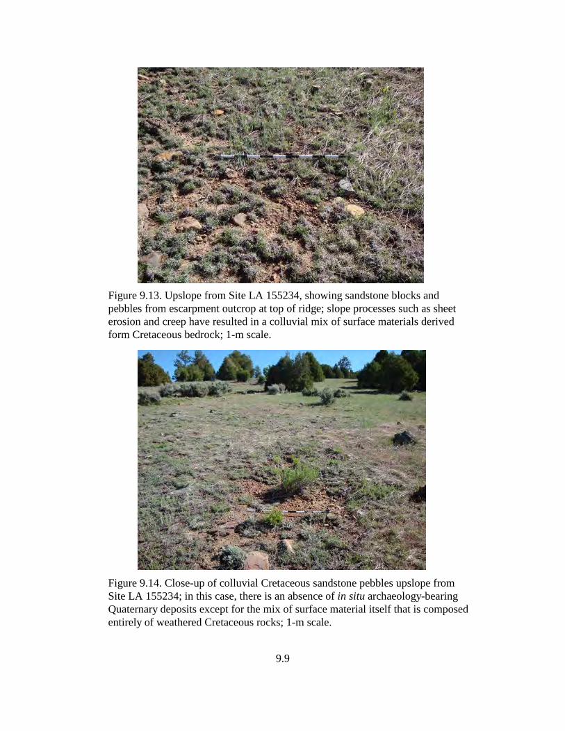
9.9
Figure 9.13. Upslope from Site LA 155234, showing sandstone blocks andpebbles from escarpment outcrop at top of ridge; slope processes such as sheet erosion and creep have resulted in a colluvial mix of surface materials derived form Cretaceous bedrock; 1-m scale.
Figure 9.14. Close-up of colluvial Cretaceous sandstone pebbles upslope from Site LA 155234; in this case, there is an absence of in situ archaeology-bearing Quaternary deposits except for the mix of surface material itself that is composed entirely of weathered Cretaceous rocks; 1-m scale.
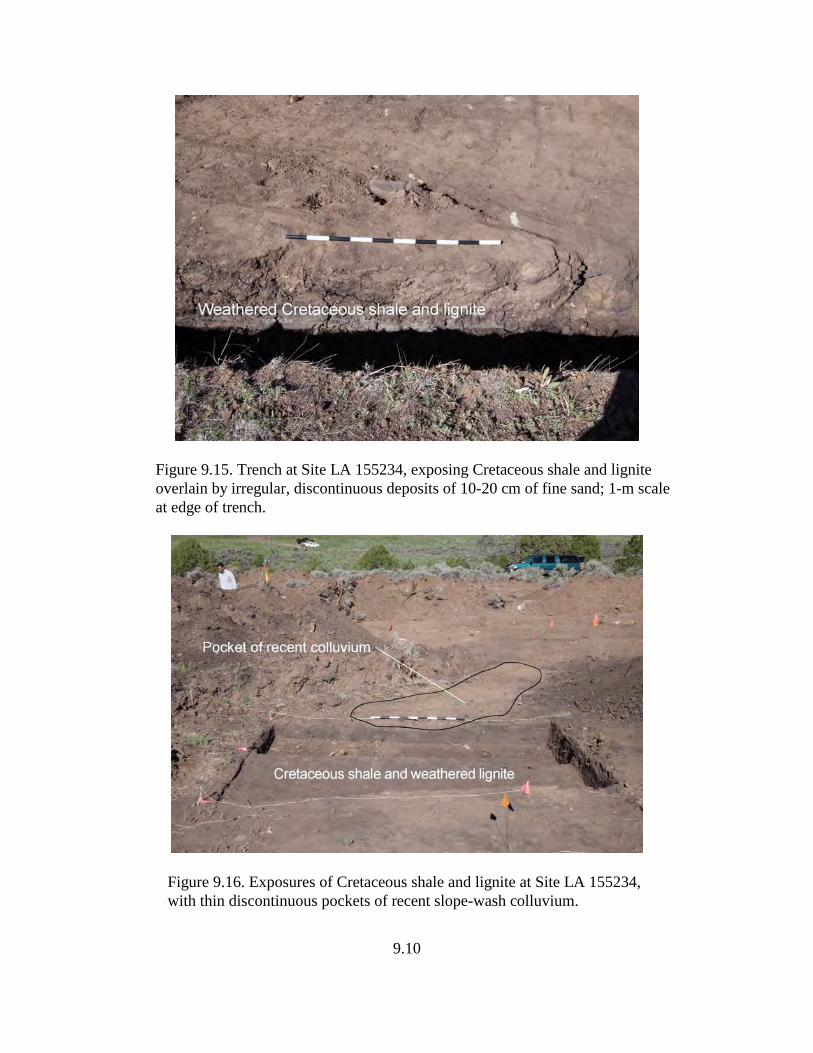
9.10
Figure 9.15. Trench at Site LA 155234, exposing Cretaceous shale and lignite overlain by irregular, discontinuous deposits of 10-20 cm of fine sand; 1-m scale at edge of trench.
Figure 9.16. Exposures of Cretaceous shale and lignite at Site LA 155234, with thin discontinuous pockets of recent slope-wash colluvium.
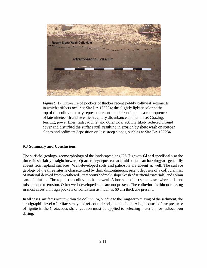
9.11
Figure 9.17. Exposure of pockets of thicker recent pebbly colluvial sediments in which artifacts occur at Site LA 155234; the slightly lighter color at the top of the colluvium may represent recent rapid deposition as a consequence of late nineteenth and twentieth century disturbance and land use. Grazing, fencing, power lines, railroad line, and other local activity likely reduced ground cover and disturbed the surface soil, resulting in erosion by sheet wash on steeper slopes and sediment deposition on less steep slopes, such as at Site LA 155234.
9.3 Summary and Conclusions
The surficial geology-geomorphology of the landscape along US Highway 64 and specifically at thethree sites is fairly straight forward. Quarternary deposits that could contain archaeology are generallyabsent from upland surfaces. Well-developed soils and paleosols are absent as well. The surfacegeology of the three sites is characterized by thin, discontinuous, recent deposits of a colluvial mixof material derived from weathered Cretaceous bedrock, slope wash of surficial materials, and eoliansand-silt influx. The top of the colluvium has a weak A horizon soil in some cases where it is notmissing due to erosion. Other well-developed soils are not present. The colluvium is thin or missingin most cases although pockets of colluvium as much as 60 cm thick are present.
In all cases, artifacts occur within the colluvium, but due to the long-term mixing of the sediment, thestratigraphic level of artifacts may not reflect their original position. Also, because of the presenceof lignite in the Cretaceous shale, caution must be applied to selecting materials for radiocarbondating.
10.1
10.0 SITE CHRONOLOGY AND DATA IMPLICATIONS
by David H. Greenwald and Peter L. Eidenbach
Although the three project sites, LA 133205, LA 133206 and LA 155234, possessed limited data setsand produced few datable samples and diagnostic artifacts, a considerable amount of informationhas been gathered from which the temporal associations of each site and site components can beassessed and interpreted. Absolute dating methods were largely limited to the use of radiometricanalyses of wood charcoal samples. Archaeomagnetic sampling was attempted, but failed to providesufficient magnetic properties and magnetic coherence to be of use. Individually, relative methodsof seriating artifacts, examining stratigraphic associations, evaluating the geomorphology of the sitesand use of obsidian hydration have provided some insights into the history and age of the sites andtheir components. Collectively, the absolute and relative methods used provide a platform fromwhich site chronology can be defined and arguments can be justified through multiple lines ofevidence and data implications. Each data set is reviewed by site; then, a discussion is presented thatinterprets the collective data.
10.1 Radiocarbon Dating
10.1.1 Site LA 133205
The initial survey report (Marshall 2001) identified a thermal feature/stain at the top of the US 64road cut; the originals of that stain were determined to be from a nearby feature, which contained asmall amount of charcoal (Sample No. 26). Enough was recovered to produce a standard AMS dateafter being submitted from this site to Beta Analytic for standard AMS dating (see Appendix B forfull presentation of Measured Radiocarbon Age, 13C/12C Ratio, Conventional Radiocarbon Age,and 2 Sigma Calibrations). Analysis of this sample resulted in three possible date ranges, calculatedat 2 Sigma (95 percent probability) (810–750 B.C.; 690–660 B.C.; and 640–590 B.C.), all falling withinthe Late Archaic period. The intercept date, which was calculated at 1 Sigma (68 percentprobability), also correlates to the Late Archaic period, between 800–760 B.C., or at 780 B.C. on thecalibration curve. The only diagnostic artifact at the site, a San Rafael projectile point (2600–1800B.C. [Jennings 1980, 1986]), was recorded by Marshall (2001) beyond the highway right-of-way. Thispoint type has a broad temporal range and is not particularly useful for establishing a tighter temporalrange for the site’s apparent single occupation. The production range of the point type is earlier thanall three possible date ranges for the radiocarbon sample, suggesting two separate occupations(unlikely given the limited artifact assemblage) or curation/reuse of earlier tools by later groups.
10.1.2 Site LA 133206
Few samples were recovered from reliable contexts from Site LA 133206. The two best radiocarbonsamples (No. 190 and 196), in terms of size and composition, were submitted from this site to BetaAnalytic for standard AMS dating (see Appendix B for full presentation of Measured RadiocarbonAge, 13C/12C Ratio, Conventional Radiocarbon Age, and 2 Sigma Calibrations). Both samples

10.2
produced multiple date ranges. Sample 190, from Feature 8, produced two possible date rangescalculated at 2 Sigma (95 percent probability), both falling within the Late Archaic period, with theintercept date calculated at 1 Sigma (68 percent probability) falling at 200–100 B.C., or at 170 B.C.
on the calibration curve. Sample 196, from Feature 12, also produced two possible date rangescalculated a 2 Sigma (A.D. 1430–1520; and A.D. 1590–1620). The intercept date, calculated at 1Sigma, fell at A.D. 1440–1470, or at A.D. 1450 on the calibration curve. Feature 12 was ofquestionable origin and later determined to be non-cultural in origin. Numerous natural burnsoccurred across the site, most representing root burns. However, Sample 196 did not appear to beroot, but rather wood charcoal. Two temporal occupations have been defined for the site, and thedating of Sample 196 indicates that a fire occurred at the site that does not appear to be related toeither the Late Archaic occupation or the historic occupation. This sample suggests that a wildfireoccurred at the site that does not appear to be associated with either occupation.
10.1.3 Site LA 155234
Two radiocarbon samples were submitted from Site LA 155234, one from the fill of Feature 4 andone from the fill of Feature 5. Both samples were small, but of sufficient size to run them as standardAMS samples at Beta Analytic (see Appendix B for full presentation of Measured Radiocarbon Age,13C/12C Ratio, Conventional Radiocarbon Age, and 2 Sigma Calibrations). Sample 125 fromFeature 4 produced two possible date ranges of A.D. 1490–1670 and A.D. 1780–1790, calculated at2 Sigma (95 percent probability). Both date ranges fell within the Protohistoric/Early Historic period.The intercept date, which falls at A.D. 1640 on the calibration curve, was calculated at 1 Sigma (68percent probability). Sample 129, from Feature 5, produced one date range of A.D. 1450–1650,calculated a 2 Sigma, falling during the late Prehistoric period into the Protohistoric period. Threeintercept dates for this sample fall at A.D. 1520, A.D. 1580, and A.D. 1630 on the calibration curve. Thereliability of these dated samples is considered good based on the similar dates produced.Additionally, Ocate Micaceous Gray pottery was recovered from the site, with a possible micaceousgray sherd recovered from Feature 4. Ocate Micaceous Gray has an assigned production datebetween A.D. 1600 and A.D. 1750 (Gunnerson 1969), which corresponds well with the date rangesprovided by the radiocarbon dates. No radiocarbon intervals were received that support a LateArchaic occupation.
10.2 Temporal Implications of the Artifact Assemblages
10.2.1 Site LA 133205
The limited lithic assemblage and absence of formal, diagnostic tools precludes an in-depth analysisof this site’s temporal associations. Field efforts were intensively focused on undisturbed portionsof the site within the US 64 right-of-way, but failed to recover diagnostic items. Marshall (2001)reported the occurrence of a San Rafael (Sudden Side-notched) projectile point south of the highwayright-of-way fence, beyond the current study area. That item provides the only indication of the site’spossible age based on the artifact assemblage. San Rafael (Sudden Side-notched) projectile pointshave been dated to a period from 2600–1800 B.C. (Jennings 1980, 1986), which places its productionwithin the Middle Archaic period.
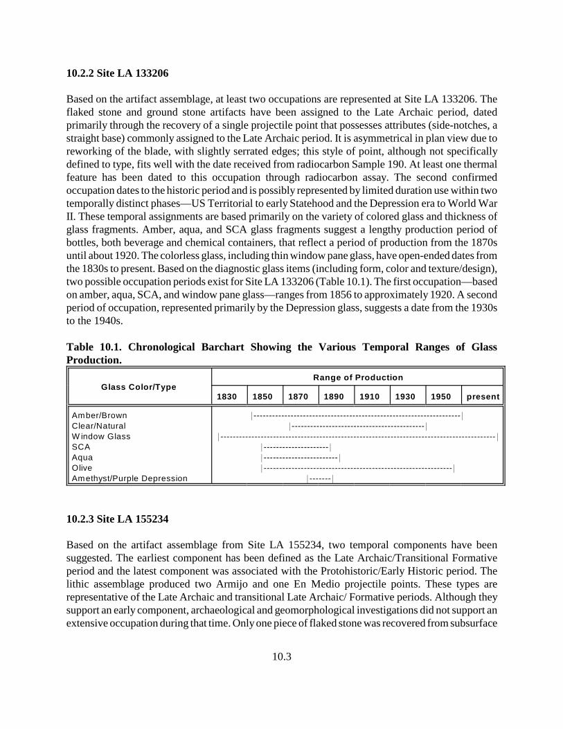
10.3
10.2.2 Site LA 133206
Based on the artifact assemblage, at least two occupations are represented at Site LA 133206. Theflaked stone and ground stone artifacts have been assigned to the Late Archaic period, datedprimarily through the recovery of a single projectile point that possesses attributes (side-notches, astraight base) commonly assigned to the Late Archaic period. It is asymmetrical in plan view due toreworking of the blade, with slightly serrated edges; this style of point, although not specificallydefined to type, fits well with the date received from radiocarbon Sample 190. At least one thermalfeature has been dated to this occupation through radiocarbon assay. The second confirmedoccupation dates to the historic period and is possibly represented by limited duration use within twotemporally distinct phases—US Territorial to early Statehood and the Depression era to World WarII. These temporal assignments are based primarily on the variety of colored glass and thickness ofglass fragments. Amber, aqua, and SCA glass fragments suggest a lengthy production period ofbottles, both beverage and chemical containers, that reflect a period of production from the 1870suntil about 1920. The colorless glass, including thin window pane glass, have open-ended dates fromthe 1830s to present. Based on the diagnostic glass items (including form, color and texture/design),two possible occupation periods exist for Site LA 133206 (Table 10.1). The first occupation—basedon amber, aqua, SCA, and window pane glass—ranges from 1856 to approximately 1920. A secondperiod of occupation, represented primarily by the Depression glass, suggests a date from the 1930sto the 1940s.
Table 10.1. Chronological Barchart Showing the Various Temporal Ranges of GlassProduction.
Glass Color/TypeRange of Production
1830 1850 1870 1890 1910 1930 1950 present
Amber/Brown
Clear/Natural
W indow Glass
SCA
Aqua
Olive
Amethyst/Purple Depression
*-------------------------------------------------------------------*
*-------------------------------------------*
*-----------------------------------------------------------------------------------------*
*---------------------*
*------------------------*
*-------------------------------------------------------------*
*-------*
10.2.3 Site LA 155234
Based on the artifact assemblage from Site LA 155234, two temporal components have beensuggested. The earliest component has been defined as the Late Archaic/Transitional Formativeperiod and the latest component was associated with the Protohistoric/Early Historic period. Thelithic assemblage produced two Armijo and one En Medio projectile points. These types arerepresentative of the Late Archaic and transitional Late Archaic/ Formative periods. Although theysupport an early component, archaeological and geomorphological investigations did not support anextensive occupation during that time. Only one piece of flaked stone was recovered from subsurface
10.4
contexts, suggesting that the lithic assemblage was restricted to the site’s surface. Geomorphologicalstudies indicated that soil development was minimal and deposition rates limited, suggesting thearchaeological remains reflect recent activities, although specific temporal ranges of those activitiescould not be defined. Therefore, behavior and subsistence strategies may have included the collectionand reuse of Archaic period projectile points by Protohistoric and Historic period aboriginal groups.This inference must remain speculation at this time, as none of the projectile points were subjectedto hydration rind measurements. However, some interesting differences were noted within the flaketool and debitage assemblage from the site, which may, in part, be associated with collection andreuse of other flake tools and large pieces of usable debitage from Late Archaic contexts (refer to thediscussion on obsidian hydration below for additional information regarding the implications of thehydration band width analysis).
10.3 Obsidian Hydration: A Relative Means of Assessing Temporal Associations
10.3.1 Site LA 133205
One artifact from Site LA 133205 was submitted to Origer’s Obsidian Laboratory for obsidianhydration band analysis. Hydration analysis provided a rind mean measurement of 2 microns for thespecimen, a relatively narrow width based on the overall project data (see Chapter 6 for a discussionof assessing hydration band analysis for the US 64 project and Appendix C for specific analyticaldata from Origer’s Obsidian Laboratory). The narrow band width is interpreted as an indication ofa late associated occupation for the site, as opposed to wider band widths, which indicate anincreased thickening of the rind through longer exposure of the surface of the obsidian. Whencompared with the project-wide hydration data, a measurement of 2 microns represents limited rinddevelopment (as opposed to rinds of up to 8 microns) and, therefore, reflects a relatively recentexposed surface. Therefore, the sample from Site LA 133205 either represents a late occupation orrecent flake removal/exposure. This interpretation is not supported by the presence of a San Rafael(Sudden Side-notched) projectile point (2600–1800 B.C.) found at the site during the survey byMarshall (2001). Additionally, the radiocarbon date ranges suggest a Late Archaic occupation;therefore, an obsidian rind band width in the range of 5 to 6 microns might be expected if this sitedates to the Late Archaic period or earlier.
10.3.2 Site LA 133206
The two obsidian specimens from Site LA 133206 that were submitted to Origer’s ObsidianLaboratory for obsidian hydration band analysis produced mean rind measurements of 3.2 and 3.6microns. As a relative dating method, these hydration band widths fall near the mid-range for theproject-wide hydration studies (range = 1.8–7.6 microns) (see Appendix C for specific analytical datafrom Origer’s Obsidian Laboratory). Through comparison with the overall project database andbased on the assumption that narrow band widths are indicative of late occupations and wider bandwidths represent progressively earlier occupations represented by thicker rinds, the samples from SiteLA 133206 support a relative temporal association that falls between the Late Archaic and perhapsthe early Formative periods. This interpretation is marginally supported by the radiocarbon results
10.5
for Sample 190 and the side-notched projectile point assigned to the Late Archaic period. Incomparison with the hydration ranges from Site LA 155234 and the single hydration measurementfrom Site LA 133205, the results acquired for Site LA 133206 imply that it was occupied somewhatlater than the earliest component at Site LA 155234 and somewhat earlier than Site LA 133205. Asa relative dating method, hydration analysis must consider the possibility that the sampled surfacesof specimens may have been exposed longer than the occupation of the site or represent later (post-occupational) flake removal through environmental disturbance or reuse by later groups. Amonggroups who practiced opportunistic collection and reuse of earlier deposits, such as the JicarillaApache, it is possible to find projectile points, bifaces, cores, and utilized flakes in the assemblagethat were produced by earlier groups. Such items, when subjected to hydration analysis, may providedates that are not indicative of the actual site occupation and suggest the presence of an earliercomponent.
10.3.3 Site LA 155234
Obsidian hydration band analysis, conducted by Origer’s Obsidian Laboratory on 12 specimens fromSite LA 155234, produced mean rind measurements that ranged from as narrow as 1.8 microns to7.6 microns. This is largest sample from the US 64 project and has resulted in the greatest range inband width from the project (see Appendix C for specific analytical data from Origer’s ObsidianLaboratory). Two extremes in band width were noted within the sample, leading to the inference thattwo temporal components are represented at the site. Of course the inference is based on theassumption that narrow band widths are indicative of late occupations and wider band widthsrepresent progressively earlier occupations. Other sources of supportive evidence are necessary todefine the temporal associations, since assignment of absolute temporal associations cannot be madefrom rind band width measurements alone. At Site LA 155234, a Late Archaic/TransitionalFormative period occupation is supported by the projectile points and a second occupation datingto the very late Formative, Protohistoric, and/or Historic periods is supported by radiocarbon datesand the occurrence of Ocate Micaceous pottery. Although a Late Archaic/Transitional Formativeperiod occupation is supported by the mean hydration rind band widths of 4.7 to 7.6 microns,consideration must be given to the possibility that the three points could have been collected andreused by later groups. The geomorphology at the site also suggests late formation processes and ageneral lack of accumulated Holocene-age deposits, resulting in a limited number of subsurfaceartifacts, possibly representing recent site occupation. Therefore, the early component cannot beconfirmed, whereas the later component is supported by the ceramics, radiocarbon dates, and meanhydration rind band widths of <4.2 microns, and possibly by only the single band width of 1.8microns.
10.4 Stratigraphy and Geomorphological Interpretations
10.4.1 Site LA 133205
The natural stratigraphy of the site is described (see Chapter 9) as being formed by Cretaceous shale,with some local lignite, on a low ridge. Evidence from the features and control units suggest the
10.6
sediment overlying the weathered bedrock is very thin; Hall (this report) suggests the colluvium isof Late Holocene age because soil formation has not occurred. Cultural features at this site occur inthe colluvial deposits and directly on the weathered Cretaceous bedrock. The stratigraphicimplications suggest that the area has remained largely unchanged since the colluvium wasdeposited. Hall’s suggested “Late Holocene” age for the colluvium and the presence of culturaldeposits that date less than 3000 years in age do not seem to contradict one another (see Chapter 9).Furthermore, the absence of soil and buried cultural deposits at the site suggests the cultural depositsare of relatively recent age. The radiocarbon results suggest an associated age less than 3000 years.
10.4.2 Site LA 133206
The site is on the top of a low hill on the north and south sides of US 64. The archaeological remainsare located upon and intrude into Cretaceous shale, with a limited area of late Holocene colluviumpresent, overlying the shale deposits. The colluvium, composed of light brown silty sand, rangesfrom 3-50 cm, partly owing its thickness to disturbances associated with US 64. Although weak, anA horizon is present in a few areas. The site area lacks a B horizon, and does not have visiblecarbonates, indicating soil development has been slow to occur. Cultural deposits are mixed withinthe upper part of the colluvial sediments. Hall (see Chapter 9) suggests that buried cultural depositsare unlikely at Site LA 133206 due to the recent age of the colluvium and its discontinuous characteracross the site. Horizontal stratigraphic associations were not observed at the site, with bothprehistoric and historic deposits occurring on the surface and within the first few centimeters. Thissuggests that the area was not subject to accumulations of aeolian or alluvial sediments that mayhave buried cultural remains, that the area was subject to a weak development of soil, and, in spiteof its multiple occupations, has remained largely unchanged since the colluvium was deposited.Hall’s suggested “Late Holocene” age for the colluvium and the presence of cultural deposits thatdate less than 3000 years in age do not seem to contradict one another (Chapter 9). The developmentof a weak A horizon supports the notion that sediments at the site are of recent age, dating to the lateHolocene.
10.4.3 Site LA 155234
Site LA 155234 occurs upon a Cretaceous shale with sandstone, lignite and low-grade coal on aslope north of US 64. The deposits of lignite occur as exposed stained areas on the surface as wellas concentrated subsurface deposits. The surface exposures were mistaken during the survey(Kuru’es et al. 2007) as surface cultural stains. Upon excavation and mechanical scrapping of thesite area, it was determined that these “dark stains” were produced from natural lignite deposits andhad no association with the occupation of the site. The natural stratigraphy also has a thin layer ofcolluvium, which probably dates to the late Holocene. Hall (Chapter 9) suggests that it is unlikelythat buried cultural deposits occur at this site because of the discontinuous deposits of colluvium.Artifacts were recovered from within the colluvium, but it is unknown whether the artifacts are insitu or were displaced from erosional processes. Artifact recovery, however, from the colluviumrepresents only about 1 percent of the total site assemblage. In short, Site LA 155234 lacksaccumulated deposits that support cultural deposition or contain subsurface artifacts and remains ofpast cultural activities.
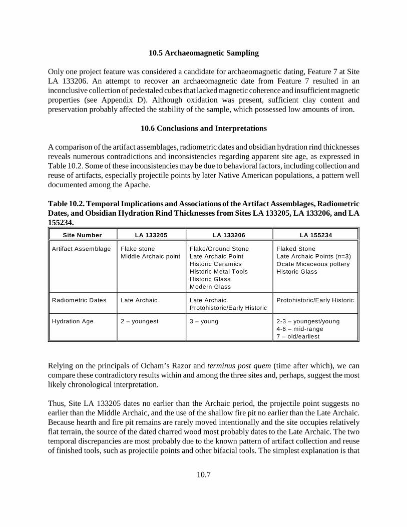
10.7
10.5 Archaeomagnetic Sampling
Only one project feature was considered a candidate for archaeomagnetic dating, Feature 7 at SiteLA 133206. An attempt to recover an archaeomagnetic date from Feature 7 resulted in aninconclusive collection of pedestaled cubes that lacked magnetic coherence and insufficient magneticproperties (see Appendix D). Although oxidation was present, sufficient clay content andpreservation probably affected the stability of the sample, which possessed low amounts of iron.
10.6 Conclusions and Interpretations
A comparison of the artifact assemblages, radiometric dates and obsidian hydration rind thicknessesreveals numerous contradictions and inconsistencies regarding apparent site age, as expressed inTable 10.2. Some of these inconsistencies may be due to behavioral factors, including collection andreuse of artifacts, especially projectile points by later Native American populations, a pattern welldocumented among the Apache.
Table 10.2. Temporal Implications and Associations of the Artifact Assemblages, RadiometricDates, and Obsidian Hydration Rind Thicknesses from Sites LA 133205, LA 133206, and LA155234.
Site Number LA 133205 LA 133206 LA 155234
Artifact Assemblage Flake stone
Middle Archaic point
Flake/Ground Stone
Late Archaic Point
Historic Ceramics
Historic Metal Tools
Historic Glass
Modern Glass
Flaked Stone
Late Archaic Points (n=3)
Ocate Micaceous pottery
Historic Glass
Radiometric Dates Late Archaic Late Archaic
Protohistoric/Early Historic
Protohistoric/Early Historic
Hydration Age 2 – youngest 3 – young 2-3 – youngest/young
4-6 – mid-range
7 – old/earliest
Relying on the principals of Ocham’s Razor and terminus post quem (time after which), we cancompare these contradictory results within and among the three sites and, perhaps, suggest the mostlikely chronological interpretation.
Thus, Site LA 133205 dates no earlier than the Archaic period, the projectile point suggests noearlier than the Middle Archaic, and the use of the shallow fire pit no earlier than the Late Archaic.Because hearth and fire pit remains are rarely moved intentionally and the site occupies relativelyflat terrain, the source of the dated charred wood most probably dates to the Late Archaic. The twotemporal discrepancies are most probably due to the known pattern of artifact collection and reuseof finished tools, such as projectile points and other bifacial tools. The simplest explanation is that
10.8
the site and virtually all of its assemblage dates to the Late Archaic when an earlier projectile pointwas recovered and redeposited. The one obsidian flake exhibited a hydration rind narrower than allothers but one from all three project sites. In comparison to the other sites, rinds this thin(approximately 2–3 microns) tend to be associated with sites with a distinct Protohistoric temporalcomponent. Several possibilities suggest themselves: first, the flake may be a recent fresh break froman older, possibly Archaic, biface. Second, the flake may have been inadvertently dropped by a morerecent passer-by as they traveled along what might have been an established route. Or third, the flakemay have been mechanically produced in more recent times by wildlife or during railroad and/orroad construction. In all these circumstances it is most reasonable to conclude that the obsidian flakewith this hydration rind is unlikely to be associated with the rest of the site assemblage, which mostprobably represents a single component site that dates to the Late Archaic.
Site LA 133206, by contrast, is unquestionably a multi-component location of Late Archaic,Protohistoric, and historic and modern activities. Radiocarbon dates suggest use and/or occupationat least during the Late Archaic period, which is supported by the recovery of a Late Archaicprojectile point, and during the Protohistoric/Historic periods. The presence of both historic and earlymodern glass and historic ceramics suggests both historic and modern use of the site, as well. TheProtohistoric/Historic use was almost certainly Native American, perhaps Apachean. The source ofthe historic use is less certain. While Jicarilla Apache still utilized the area, Euroamerican settlershad arrived and begun to mine local coal to supply the newly arrived railroad. The historic glass isconsistent with the dates of the founding of Amargo (1881), Dulce (1882), and nearby Monero(1884). The modern glass could also be from alternate sources. The two obsidian flakes examinedfor hydration rinds both exhibit moderate rind thickness, 3.2 and 3.6 microns. Thus, they werebroken somewhat earlier than the example from Site LA 133205, and later than most of the examplesrecovered from Site LA 155234 (below). The hydration rinds reflect a reasonable relative correlationwith the flaked stone assemblage, the Late Archaic projectile point, and the Late Archaic periodradiocarbon date. The ground stone materials could also be from the Late Archaic or theProtohistoric/Historic periods, when Jicarilla and other Apachean groups were processingeconomically important native plant resources and perhaps faunal resources. The limited tools, cansand historic glass could be materials scavanged by historic Native American populations or theycould be related to the railroad and nearby settlement. Arrival of Euroamerican groups and therailroad increased access by Native Americans to these goods and discarded containers. Thus, SiteLA 133206 was used/occupied during the Late Archaic, Protohistoric/Early Historic, Late Historic,and Modern periods.
At Site LA 155234, the presence of Ocate Micaceous ceramics, an Apachean pottery, and historicglass agrees well with the Protohistoric/Historic radiocarbon dates and perhaps a later historiccomponent. The numerous examples of obsidian at this site clearly indicate this location’s use fortool production, perhaps during several periods. The Apachean ceramics agree temporally with theradiocarbon date intervals, but the range in obsidian hydration rind thickness from young (1.8microns, similar to Site LA 133205), through moderate (4.1–5.0 microns) to old (older) (6.0–7.6microns) suggest the Protohistoric, Late Archaic, and an even earlier component (although an earliercomponent is not supported through other temporally-sensitive indicators).

10.9
The Protohistoric/Early Historic radiocarbon dates and the three Late Archaic projectile points seemto confirm at least two of these periods. The eight moderate ring-thickness obsidian specimens, twoof which came from a subsurface context, also support the presence of the Late Archaic andtransitional projectile points. The two pieces of obsidian with the greatest rind thicknesses, both froma surface context, are the extent of the evidence suggesting the possibility of earlier component and,thus, may be discounted for lack of other physical evidence. These two samples, like the examplefrom Site LA 133205, may well have been brought in from elsewhere by later groups.
11.1
11.0 PROJECT REVIEW AND SUMMARY
by David H. Greenwald and Peter l. Eidenbach
Data recovery efforts along US Highway 64 between Lumberton and its junction with US Highway84, west of Chama, New Mexico, in Rio Arriba County, were conducted as part of a highwayimprovement project that included widening the highway within the existing right-of-way andconstruction of new roadway through newly acquired right-of-way. The three sites included in theproject had previously been determined eligible for inclusion to the National Register of HistoricPlaces under Criterion (d) and highway improvements to US 64 would adversely effect the sites;therefore, a program to mitigate the adverse effects to the sites was implemented by Four CornersResearch for the New Mexico Department of Transportation. Based on the project design, Sites LA133205 and LA 133206 would receive impacts through road improvements and widening; Site LA155234 would receive impacts through construction of new roadway and associated features(construction of bar-ditches, drains and culverts, and fences). Although efforts were confined to theexisting and newly acquired highway right-of-way, recovery efforts were rewarded with significantdata interpretations from sites that yielded few features and possessed small artifact assemblages.That relationship—significant data interpretations from few features and small artifactassemblages—may seem like a conflict of terms, but in the case of the US 64 data recovery efforts,interpretations of the artifact data, feature data, chronometric and special sample analyses, andgeomorphology were generally not clouded by lengthy or complex occupations of the sites, extensivedisturbances by later occupations or natural processes, or extensive intermixing of cultural deposits.The multi-disciplinary approach enabled comparisons to be made of the various data sets, fromwhich interpretations were drawn and conclusions presented. Some issues could not be resolved orfully addressed, and in some cases the research questions that had been posed could not be addresseddue to insufficient data. Yet, as the preceding chapters demonstrate, considerable knowledge hasbeen gleaned from these “low-intensity” and limited-use sites, sometimes represented by brief,multiple occupations. The following presentation examines the project data results and evaluates theapplicability of the research design. An attempt also has been made to place the projectinterpretations into a regional context.
11.1 Focus of Research
Project research was tied to current regional issues and specific local topics. Five problem domainswere identified as research topics applicable to this project (see Chapter 3). Research questions anddata requirements were identified for each problem domain, and these served as the basis fordirecting and integrating research issues among the various data categories that the project produced.For example, Problem Domain 2, Subsistence and Economy, was examined through a host of datacategories, including an examination of the natural resources of the project area, acquisitionstrategies that included interaction and exchange, sources of materials, tool functions, and anexamination of faunal and botanical resources. Similarly, Problem Domain 1, Cultural/TemporalAffiliations, incorporated various lines of evidence and dating techniques in an attempt to recognizeethnic groups and their associated occupation episodes. Historic documents and ethnographic sources
11.2
were consulted to better understand and demonstrate the patterns that emerged during the course ofthe project. The gathered data supported some of the previous researchers’ observations that theproject sites represented considerable difference in function, age, and cultural affiliations.
11.1.1 Summary of Sites Investigated
11.1.1.1 Site LA 133205
Site LA 133205 was initially described as a “prehistoric encampment” that dated to the San Rafaelphase (3500–1800 B.C.) of the Archaic period, based on a single San Rafael (Sudden Side-notched)projectile point (Marshall 2001). That characterization was found to be accurate, although the ageof the site has been determined to be later, based on the date received from the single radiocarbonsample (Sample No. 26: 810–750 B.C.; 690–660 B.C.; and 640–590 B.C. calculated at 2 Sigma [95percent probability], with an intercept date between 800–760 B.C., or at 780 B.C. on the calibrationcurve) (Appendix B). Using the results of this single radiocarbon sample, the site has been assignedto the Late Archaic period. However, obsidian hydration analysis conducted on a single specimenfrom this site does not provide support for the radiocarbon date interval nor the assignment of thesite to the Late Archaic period. When considering the relative temporal range of the hydration resultswith the overall project results, the mean rind measurement of 2 microns for the specimen isrelatively narrow and supports an interpretation of representing a late temporal association or recentexposure that resulted in limited rind development. Therefore, the sample from Site LA 133205either represents a late occupation or recent flake removal/exposure. The inherent problem with theobsidian hydration results is its interpretive value, with the rind thickness only an indication of arelative measure of time; this relative measure serves only as an indication of age when comparedwith other project hydration rind measurements, which, in this case, suggests a late association forthe specimen from Site LA 133205.
After examining and weighing all lines of evidence, including the geomorphology, Site LA 133205has been assigned to the Late Archaic period based on the most reliable dated samples from the site.The limited number of both features and artifacts indicate activities of a temporary encampment,perhaps representing a single occupation episode. Although difficult to demonstrate, the occurrenceof the Middle Archaic projectile point probably represents a single example of prehistoric artifactcollection and reuse of finished tools, unless the portion of the site that extends beyond the US 64right-of-way (where Marshall found the San Rafael point) represents a Middle Archaic occupation.Our efforts restricted the focus of the recovery to the area within the US 64 right-of-way, leaving thearea beyond unevaluated at this time. The occurrence of tools that represent earlier time periods thanthe overall artifact assemblage is often identified among archaeological assemblages. Rather thanrepresenting earlier occupation episodes, such items can reflect reuse of earlier tools, i.e., curatorialbehavior by indigenous groups. This very well may be the case for Site LA 133205.
To further evaluate the function of the site, macrofloral and pollen samples were analyzed todetermine what economically important plants were available and which ones may have beenexploited by the site occupants. Charred goosefoot seeds suggest they were used by site occupants,
11.3
either parched for food or as green plants in association with processing other foods. CharredPoaceae C caryopsis fragments suggest that grasses producing small seeds were used as food ortinder, as weaving materials, for processing other foods, or for other purposes. The charcoal recordindicates that both juniper and pine were burned as fuel. The pollen record indicates sagebrush wascommon, as it is today, and moderate quantities of Pinus and Cheno-am pollen, small quantities ofAbies, Low-spine Asteraceae, High-spine Asteraceae, Brassicaceae, and Poaceae pollen, indicate thatregional and local vegetation also included pine, Cheno-ams, fir, various members of the sunflowerfamily, members of the mustard family, and grasses. Few data were recovered from the macrofloraland pollen samples, a result of the limited range of activities conducted at the site or poorpreservation. Given the limited artifact assemblage and the presence of only two features, the narrowrange of taxa represented in the botanical record is probably associated with the limited occupationof the site, rather than preservation problems.
Site LA 133205 produced the largest portion of the project faunal assemblage, with all of theelements representing dietary remains. Cut marks and burning were not found on any of theelements. However, the range of elements was represented by small, medium large and largemammals, most likely of common taxa that represent cottontail rabbit, deer, and possibly bison (asopposed to bovine). The occurrence of foot bones from both the deer and the bison suggest the sitewas located near the hunting/kill site, as these elements of large game animals are generally nottransported long distances from the kill site to the occupation site. Therefore, it may be concludedthat Site LA 133205 represents a hunting camp, located near a kill site that was occupied during theLate Archaic period.
Collectively, the data recovered from Site LA 133205 support the interpretation that the siterepresents a short-term encampment used by highly mobile hunter/gatherer groups during the LateArchaic period. The limited number of features encountered, the small number of items that composethe artifact assemblage, and the narrow range of botanical taxa recovered from macrofloral andpollen samples support the supposition that the site was used for a brief period of time, perhaps fora single event. The faunal remains indicate that hunting was probably associated with the siteoccupation; recovered elements suggest the site was located near the kill site.
11.1.1.2 Site LA 133206
Originally described as a “multi-component” prehistoric lithic artifact scatter (with two associatedhearths) and a historic artifact scatter, with a corral (Marshall 2001:34-37), this site possesses severaltemporal elements ranging from the Late Archaic period into the late Historic/Modern period. Thecorral represents the latest use of the site, incorporating oak rails that retain bark and military surplushardware; it is still in use. Marshall’s initial assessment of the site was relatively accurate. Heassigned the lithic artifact scatter to the Archaic period, in spite of lacking any diagnostic items thatmay have allowed a tighter temporal assignment. He also assigned the historic artifact scatter to theUS Territorial period, suggesting a date range from 1880 to 1910, and a cultural affiliation ofAnglo/Hispanic. Data recovery efforts have identified three components, represented by a LateArchaic artifact scatter and associated features, a historic occupation associated with the US
11.4
Territorial period, and a historic occupation associated with the Depression era, perhaps extendinginto World War II. Less apparent, and unconfirmed by the present efforts, is a possible Historicaboriginal occupation.
Marshall’s (2001:34-37) description of two hearth features exposed at the top of the slope cut on thesouth side of US 64 resulted in focusing our efforts on investigating these stains and other featuresfound at the site. The two stains reported by Marshall were determined to be natural deposits oflignite-enriched clay, common to the geology of the area. Similar exposures were found in theopposite slope cut of US 64 and examined by Steve Hall, project geomorphologist. Efforts elsewhereat the site discovered a small midden deposit of historic association and two thermal features and onestain of probably Late Archaic association.
Chronological interpretations were aided by the artifacts recovered from the site. Amber, aqua, andSCA glass fragments, which represent a lengthy production period of glass containers, reflect aperiod of production from the 1870s until about 1920. Depression glass suggests a date from the1930s into the 1940s. Based on the diagnostic glass items (including form, color and texture/design),two possible occupation periods exist for Site LA 133206. The first occupation, based on amber,aqua, and SCA glass, ranges from ca. 1870 to 1920; with arrival of the Denver and Rio GrandeWestern railroad in the area in 1881, a compressed date range of ca. 1881 to 1920 seems reasonable.A second period of historic occupation dates to the Depression era, approximately ca. 1930 to 1940.
The radiocarbon samples (No. 190 and 196) submitted for analysis (Appendix B) provide someinsights into defining the temporal associations of the lithic artifact scatter and associated features.Although both samples produced multiple date ranges, Sample 190, from Feature 8, produced twopossible date ranges calculated at 2 Sigma (95 percent probability) (350–290 B.C.; and 220–50 B.C.),both falling within the Late Archaic period, with the intercept date, falling at 200–100 B.C., or at 170B.C. on the calibration curve. Sample 196, from Feature 12, also produced two possible date rangescalculated a 2 Sigma (A.D. 1430–1520; and A.D. 1590–1620), with an intercept date falling betweenA.D. 1440–1470, or at A.D. 1450 on the calibration curve. Feature 12, however, was determined to benon-cultural in origin, being a natural burn, one of many noted at the site. Sample 196 indicates thata wildfire occurred at the site that does not appear to be related to either the Late Archaic occupationor the historic occupation. The only diagnostic artifact associated with prehistoric use of the site wasa single projectile point that exhibits attributes commonly assigned to the Late Archaic period. Aspecific temporal assignment could not be made based on this projectile point, but its form andgeneral temporal assignment supports the results of radiocarbon sample No. 190 and strengthens thesite’s Late Archaic associations. The ground stone materials could also be from the Late Archaicperiod, although it cannot be specifically assigned to any temporal period based on its form orprovenience. A Historic period indigenous occupation at this site should not be ruled out. Jicarillaand other Athabascan/Ute groups are known to have occupied the general area and processedeconomically important native plant resources and perhaps faunal resources. The mixed assemblageof lithic items, metal tools, cans and historic glass could be materials scavenged by historic NativeAmerican populations. However, the simplest explanation is that these Euroamerican items wereintroduced and deposited by Anglo/Hispanic groups following the arrival of the railroad and
11.5
establishment of nearby settlements, as a Historic indigenous occupation is weakly supported. NativeAmerican access to Euroamerican goods, however, was greatly increased after 1880 in the projectarea. Therefore, a historic indigenous occupation of Site LA 133206 cannot be ruled out even thoughitems, such as flaked glass and cut/worked metal, were not recovered.
Results of the obsidian hydration band-width analysis (Appendix C) is difficult to interpret for thissite. The mean rind measurements of 3.2 and 3.6 microns fall near the mid-range for the project-widehydration studies (range = 1.8–7.6 microns) and seem to suggest a temporal association with theFormative period or, at the earliest, with the Late Archaic period, an interpretation that is marginallysupported by the radiocarbon results for Sample 190 and the side-notched projectile point assignedto the Late Archaic period. No other evidence was recovered that supports a Formative periodassociation.
In evaluating site function and the range of activities conducted at Site LA 133206, macrobotanicaland pollen samples were submitted from two features believed to represent part of the prehistoricoccupation. Feature 7, a circular thermal feature that contained tabular pieces of fire-alteredsandstone, was dominated by Pinus and Artemisia along with small quantities of Low–spineAsteraceae, High-spine Asteraceae, Cheno-am, Eriogonum, and Poaceae pollen that reflect localvegetation of various members of the sunflower family, Cheno-ams, wild buckwheat, and grasses.Charred Poaceae C caryopsis and charred caryopsis fragments indicate use of grasses with smallseeds. Juniper and pine were burned as fuel in this feature.
Feature 8 was a shallow, circular basin feature with an oxidation rind. The pollen record isdominated by Pinus pollen, with a moderate quantity of Artemisia pollen also present. Smallquantities of Picea, Juniperus, High-spine Asteraceae, Cheno-am, Ephedra nevadensis-type,Poaceae, and Typha latifolia-type pollen represent pine, juniper, sagebrush, various members of thesunflower family (rabbitbrush and Cheno-ams), and grasses probably representing vegetationgrowing in the vicinity of the site. Cattail pollen indicates a nearby water source. Charred remainsof sagebrush or another woody member of the sunflower family were present. Recovery ofHordeum/Elymus-type starch indicates either local growth of at least little barley grass and possiblyalso wild rye or perhaps exploitation of the seeds of these grasses, including evidence of cooking.The macrofloral evidence from Feature 8 included a few fragments of charred, vitrified tissue anda few charred bark fragments. The charcoal record was dominated by pine, with a few fragments ofjuniper and Douglas fir.
Limited food processing/cooking of economically important taxa is represented at Site LA 133206.This indicates that plants as food resources were not a focus of activities at the site, plants that arenot likely to yield preserved elements were exploited, or the use of thermal features were associatedwith other activities, perhaps heat/warmth or cooking of resources, resulting in few physical remainsthat survive within the archaeological record. Starch grains of little barley grass or wild rye providethe only conclusive evidence of economically important plants being used as a food resource duringthe site’s prehistoric occupation.
11.6
Few faunal remains were recovered from the site. At least one specimen represented the historicoccupation of the site, indicated by metal saw cut marks on a large mammal. A cottontail humerusfragment was recovered from Feature 4, the historic midden, and was calcined, suggesting it also waspart of the historic assemblage. The medium and large mammal shaft fragments were calcined, againsupporting the interpretation that these bones represent dietary remains; however, they could not beassigned to a specific temporal component. The faunal assemblage, although small, suggests thathunting was used by some or all groups that occupied the site, with one recognized common meatcut, a round steak, represented.
Few diagnostic artifacts were recovered from the site. The single obsidian projectile point, whichcould not be specifically identified as to type, exhibits side notches and attributes of both dart andarrow points. Its morphology suggests a Late Archaic-period association. The limited lithic artifactassemblage was represented by flake fragments and platform-bearing flakes, with few retainingcortex. Interpreted as representing patterns of mobility, the site probably represented a temporarycamp site. Because of the fragmentary nature of the ground stone assemblage, it was not helpful indefining the temporal associations of the site. A pecked surface on at least one metate fragmentimplies the grinding of coarse seeds, perhaps corn. However, conditions would have had to havebeen milder than today to receive enough frost-free days to achieve germination of seed, maturation,and a successful harvest. In all likelihood, the ground stone tools were used to prepare a number ofwild seeds and faunal species. Few activities have been defined from the data collected at Site LA 133206. Ground stone indicatesreductive activities, perhaps associated with the grinding of seeds. Other food items were limited tosmall charred grass seeds and altered starch grains of either little barley or rye grass, indicatingcooking of these or similar resources. Faunal remains were associated with the historic occupationand may have been associated with the prehistoric occupation as well, although none of the faunalremains were recovered from contexts directly associated with the prehistoric occupation of the site.The archaeological record has not provided many clues as to the activities conducted at the siteduring the Late Archaic or Historic indigenous occupations, other than activities that made use ofsmall, shallow thermal pits; these pits typically would be associated with food processing/preparationor heating. At Site LA 133206, they exhibit limited evidence as food preparation features andprovide little information about the level of intensity of their use. As a result, it is difficult to arguethat the site represented a camp site used by highly mobile hunter/gatherers. If the quantity of flakedstone items is indicative of the level of use, this site was used more extensively than Site LA 133205,yet its information yield is less informative.
Observations made to the south of the US 64 right-of-way indicate that a rather substantial historicoccupation did occur at the site, represented by one or two structures, which may account for muchof the historic artifact assemblage found in the right-of-way and its diversity. The midden (Feature4) represents discard behavior, with some cultural items discarded as well; the composition of themidden, however, does not support the discarding of trash but rather the repeated dumping of an ashbox associated with the use of a wood-burning stove. The presence of metal pieces that may havebeen fragments of a grate used within a wood-burning stove indicates that residents used a stove for
11.7
either heating or cooking or both. Metal artifacts, such as the cork screw and screw driver, lendsupport to an Anglo/Hispanic occupation that had access to items available through commercialmarkets. Unlike a short-term encampment used by prehistoric and historic indigenous groups, SiteLA 133206 lacks many elements that can definitively be used to describe it as such. Its historicEuroamerican associations, however, are more easily recognized, although limited to surfacescattered artifacts, a small midden, and various items of commercial production (as opposed tovernacular items) within the US 64 right-of-way and the uninvestigated structural remains andartifacts beyond the right-of-way. The narrow range of botanical taxa recovered from macrofloraland pollen samples support the supposition that the site’s prehistoric and historic indigenous userepresents an ephemeral occupation, perhaps single events related to the Late Archaic period and theHistoric period.
The historic artifact assemblage provides a reasonable confirmation that the site’s occupation wasassociated with a period that postdates 1880 and possibly contains two occupation episodes.Following the arrival of the Denver and Rio Grande Western railroad or roughly contemporaneouswith it, the artifact assemblage supports an occupation that may have lasted up to 1920, based on thebroadest range of production dates of items such as SCA glass. The second occupation dates fromroughly 1930 until about 1940. To address the research design (Problem Domain 2: Subsistence andEconomy; and Problem Domain 5: Historic Aboriginal vs. Euroamerican Associations), the projectemployed the use of functional groups of historic artifacts, following those defined by South (1977).As originally designed, use of these functional groups would help determine if and how NativeAmericans made use of different historic artifacts of Euroamerican production. However, no directevidence was found to support Native American use of Euroamerican items. Therefore, functionalgroups were examined to evaluate the extent that site residents (regardless of ethnicity) used historicperiod artifacts and the activities that could be defined by their presence and any recognizedmodifications. Following South (1977), categories that were considered included a domestic artifactgroup, architecture group, clothing group, personal group, tool group, hardware group, and amiscellaneous category for other items. South further divided the domestic artifact group into foodand drink, hygiene, medicine and pharmaceutical, tableware, and other subcategories.
Several conclusions have been reached regarding the implications of the artifact assemblage andsubsistence strategies employed at Site LA 133206, as well as whether the assemblage representsAboriginal or Euroamerican use. First, site residents had direct access to Euroamerican goods, aresult of market access made available through the construction of the Denver and Rio GrandeWestern railroad. Not only did the railroad provide access to Euroamerican market goods, it alsoresulted in the establishment of rail line communities, migrant and permanent residents in the area,and interaction with Native populations. Ethnicity of the historic artifact assemblage, however, lackselements that allow the assemblage to be linked to any groups (Hispanic or Native American) otherthan Euroamerican/Anglo groups. Few items exhibit Hispanic associations, although acquisition anduse by Hispanic populations cannot be ruled out, as rail systems provided greater access to goods bymore ethnic groups. Had Hispanic populations been present at Site LA 133206, Hispanic pottery oritems with Hispanic maker’s marks would be anticipated within the assemblage. Furthermore, noevidence was found to indicate that Native Americans acquired or modified any of the Euroamerican
11.8
artifacts. All of the artifacts recovered represent commercially produced items accessible fromEuroamerican markets. Vernacular or hand-forged items were not recovered, perhaps indicatingaccess to commercial items was easily achieved. The lack of modified items or vernacular items mayreflect a brief occupation, perhaps directly related to the construction of the railroad. An occupationof greater duration would be expected to result in a much larger artifact assemblage and a numberof modified artifacts. Modification, reuse, or salvaging of artifacts was not observed within theassemblage, further suggesting the brief occupation of the site. It is most probable that the earliesthistoric occupation of the site reflects a direct association with the railroad (either its constructionor later operation) and an occupation of short duration. The later occupation, ca. 1930–1940, mayhave been even less intense than the original, being associated with a brief and limited use of the site,perhaps related to area ranching.
In consideration of South’s (1977) functional groups of artifacts, the groups represented are domesticgroup, clothing group, personal group, tool group, and hardware group. The historic artifactassemblage at Site LA 133206 supports an Anglo occupation, lacks items that demonstrate aHispanic association, and does not support a Native American presence after 1880.
11.1.1.3 Site LA 155234
Site LA 155234 was discovered in newly acquired highway right-of-way obtained from privatesources. It was described as a “lithic artifact scatter with a thermal feature remnant” by Kuru’es etal. (2007). A cultural/temporal association was not assigned to the site at the time of its discoverydue to a lack of diagnostic artifacts; however, a Late Archaic association was suggested based on the“high quality lithic materials” and the “high occurrence of biface thinning flakes” (Kuru’es et al.2007:31). Based on the thermal feature and artifact assemblage, Kuru’es et al. (2007) suggested thesite functioned as “a short-term locus of seasonal occupation” that may have been reused throughtime. Lacking any specific temporal/cultural markers, our approach to investigating the site was toconsider the broad range of possibilities. The “high quality lithic materials” and “high occurrenceof biface thinning flakes” could be assigned to any group who practiced a highly mobile subsistencestrategy that included access to multiple sources of quality lithic materials. Therefore, our objectiveswere to evaluate alternative temporal/cultural associations, including Protohistoric/Historic groups.
Two temporal components have been suggested for the site following completion of the artifactanalysis. The earliest component has been defined as the Late Archaic/Transitional Formative periodbased on the three projectile points (an assignment that is marginally supported by the obsidianhydration mean rind width measurements). The latest component, assigned to the Protohistoric/ EarlyHistoric period, was based on the presence of Ocate Micaceous Gray pottery (and supported by theradiocarbon date intervals received from the site). Historic glass shards suggest a possible thirdcomponent, although the limited number of pieces of glass may reflect a single visit to the site afterthe railroad reached the area and communities, such as nearby Monero, had been established.
Hall (Chapter 9) characterized the geomorphology as containing minimal soil development. Onlyone piece of flaked stone was recovered from subsurface contexts, suggesting activities associated
11.9
with the lithic assemblage were restricted to or very near the site’s current surface. Although the siteis located on a slope, erosion was minimal and does not appear to have affected the integrity of thesite’s deposits, as previously thought (Kuru’es et al. 2007). If cultural deposits were associated witha late occupation, strategies may have included the collection and reuse of Archaic period projectilepoints by Protohistoric and Historic period aboriginal groups. The range in hydration rind thickness,however, suggests at least two general periods of occupation at the site.
Excavation efforts discovered two features that contained wood charcoal. Radiocarbon samples werecollected from Features 4 and 5 and submitted for analysis (Appendix B). The sample (No. 125)from Feature 4 produced two possible date ranges of A.D. 1490–1670 and A.D. 1780–1790, calculatedat 2 Sigma, with an intercept date of A.D. 1640 on the calibration curve. The sample (No. 129) fromFeature 5 produced one date range of A.D. 1450–1650, calculated a 2 Sigma, which produced threeintercept dates of A.D. 1520, A.D. 1580, and A.D. 1630 on the calibration curve. The reliability of thesedated samples is considered good based on the similar dates produced and the discovery of OcateMicaceous Gray pottery on the site and a possible micaceous gray sherd recovered from Feature 4.The production period of Ocate Micaceous of A.D. 1600 to A.D. 1750 (Gunnerson 1969) correspondswell with the date ranges provided by the radiocarbon dates, which support a Protohistoric/EarlyHistoric period association. The small ceramic assemblage of Protohistoric/Early Historic age andthe radiocarbon date intervals are highly significant. The ceramics are known to have been producedby Jicarilla Apache groups and exchanged as trade items (Eiselt and Ford 2007) in the Northern RioGrande region. The radiocarbon date intervals support an occupation contemporaneous with theproduction of Ocate Micaceous Gray pottery, firmly defining one occupation episode of the site. Obsidian hydration band analysis (Appendix C) conducted on 12 specimens from Site LA 155234produced a broad range of mean rind measurements (1.8 to 7.6 microns). The range of mean rindmeasurements suggests a broad period of time is represented by the analyzed sample and furtherimplies that several occupation episodes may be represented by the range in mean rind widths. Rindmeasures could be grouped into at least two clusters, leading to the inference that two temporalcomponents are represented at the site, based on the assumption that narrow band widths areindicative of late occupations and wider band widths represent progressively earlier occupations. ALate Archaic/Transitional Formative period occupation is supported by the projectile points and asecond occupation dating to the very late Formative, Protohistoric, and/or Historic periods issupported by radiocarbon dates and the occurrence of Ocate Micaceous pottery. Although a LateArchaic/Transitional Formative period occupation is supported by a cluster of mean hydration rindband widths of 4.7 to 7.6 microns, consideration must be given to the possibility that the three pointscould have been collected and reused by later groups. While curation behavior among prehistoricand historic groups has been demonstrated on many occasions, projectile point morphology of thespecimens from Site LA 155234 supports an association that is supported by the thicker mean rindwidths, disallowing an occupation associated with the Late Archaic/Transitional Formative frombeing dismissed. None of the projectile points were subjected to hydration analysis; therefore, arelative period of production of these points has not been demonstrated other than through theirmorphological shape/assigned type. The Protohistoric/Early Historic occupation, which is supportedby both ceramics and radiocarbon intervals, is also supported by narrow mean rind widths. Those
11.10
specimens that produced band widths between the clusters of rind widths at each end of the hydrationrind width spectrum for the site may reflect an association with the Formative period (consideredunlikely since other Formative period materials were not recovered), represent different rates ofexposure, or represent later flake removal through natural or mechanical means.
To address site function, pollen and macrofloral samples were examined from Features 4 and 5.Feature 4 represents a shallow basin pit. Pollen recovered from the feature indicates a record similarto the vegetation present today. Recovery of cattail pollen indicates a nearby wetland area. Themacrofloral record indicates that local pine wood was burned as fuel. No other charred remainsindicative of food processing activities were recovered.
Feature 5, an elliptical, basin-shaped pit, provided a pollen record that indicated a similarenvironment as that found on the site today. Charred Asteraceae fibers attest to burning a woodymember or members of the sunflower family. The macrofloral record from this feature containedseveral charred remains, including a few herbaceous dicot stem fragments, a charred epidermisfragment, Pinus bark and needle fragments, unidentified bark fragments, and pieces of charred,vitrified tissue. Charred Polygonum seeds suggest processing of smartweed/knotweed seeds. Acharred, unidentified seed fragment might also represent seed processing activities. The charcoalrecord was dominated by oak, with a moderate amount of pine charcoal.
Based on the interpretations of the paleobotanical remains, little indication was found thatenvironmental conditions differed from present-day conditions. Site residents used local resourcesfor fuel and probably exploited other resources of economic value that occurred nearby. No evidenceof “exotic” resources were noted, suggesting long-distance trade or exploitation of resource zonesuncommon to the general project area.
Arguably, two temporal components are represented at Site LA 155234, separated minimally by1200 to 1400 years. Both components represent short-term, perhaps re-occurring occupations byhighly mobile hunter/gatherer groups. The earliest occupation occurred during the LateArchaic/Transitional Formative period, while the later occupation occurred during theProtohistoric/Historic period. Few data were recovered to support intensive use of the site; rather,activities were restricted to tool production/retooling, limited food processing/cooking, and reduceduse of thermal features. Neither the faunal or the paleobotanical record support much diversity ofactivity. The presence of the Ocate Micaceous pottery indicates a presence at the site of JicarillaApache or exchange and interaction with neighboring groups to the Jicarilla. Few economicbotanical taxa were recovered from the thermal features, and the faunal remains were much tooweathered to provide information on their association with the site’s occupation.
11.2 Evaluation of the Research Design
Five problem domains were identified to assist in directing the research for the US Highway 64 datarecovery project: (1) Cultural/Temporal Affiliations; (2) Subsistence and Economy; (3) Land-UseStrategies; (4) Geomorphological Associations and Implications; and (5) Historic Aboriginal vs.
11.11
Euroamerican Affiliations. When the research design was developed, a much greater artifactassemblage was anticipated, along with more and greater diversity in feature types. Due to obviouslimitations, some of the posed research questions could not be addressed. This was not a failure ofthe methods applied or the efforts generated during the data recovery phase; rather, the level ofcomplexity of resources was much less than our expectations.
11.2.1 Problem Domain 1: Cultural/Temporal Affiliations
Within Problem Domain 1, each proposed method of assessing cultural and temporal affiliations wasattempted, allowing both issues to be addressed and defined. Radiocarbon samples proved to be asignificant absolute dating tool, whereas the single application of archaeomagnetic sampling failedto provide any interpretable results. The results of the obsidian hydration provided a useful meansof assessing relative temporal associations, yet contained some problematic samples that requiredfurther consideration and alternate explanation. Anticipated within the development of the researchdesign, but unconfirmed by previous recording efforts, was the presence of micaceous graywareceramics; at Site LA 155234, the identification of Ocate Micaceous pottery in conjunction with tworadiocarbon dates confirmed a Protohistoric/Early Historic occupation of probable Jicarilla Apacheassociation. The presence of three Late Archaic projectile points required that an earlier occupationbe considered. The hydration data supported both an early and a late occupation, and, while a LateArchaic component must not be dismissed, the projectile points could represent reuse by latergroups. To this extent, Hall’s geomorphological observations (Chapter 9) provided support to manyof the temporal interpretations made, at least at a broad level. His observations at Site LA 155234also provided insights as to the stability of the site area as opposed to it being eroded and degraded,as initially thought and suggested by Kuru’es et al. (2007); this proved important in understandingthat the site largely represented a surface manifestation with little accumulation of deposits in whichearlier cultural remains could be anticipated and supported observations made regarding the temporalaffiliations of the site.
Similar issues existed at Site LA 133205, which probably represent a single occupation episodeduring the Late Archaic period by a group of hunters. Diagnostic artifacts were not recovered. Theradiocarbon date supports a Late Archaic temporal affiliation, whereas an obsidian sample provideda mean rind width that implies a later association. Evaluation of the site’s geomorphology indicatesthat it does not possess deep accumulated Holocene deposits, lacking buried or stratified culturaldeposits.
At Site LA 133206, a low-density lithic assemblage resulted in the assignment of a probable LateArchaic occupation. A single Late Archaic/Transitional Formative projectile point and a radiocarbondate support this interpretation. Again, Hall’s assessment of the geomorphology (Chapter 9)describes the site area as possessing shallow Holocene deposits, which reduce the likelihood for thepresence of buried cultural deposits. The historic artifacts presented other challenges. Artifactanalyses revealed that two periods of use likely occurred at the site, between approximately 1880 and1920 and between 1930 and 1940. The estimate of 1920 remains an approximation that is hingedupon the broadest range of artifact production dates; given the limited assemblage, the occupation
11.12
may have been much shorter, perhaps only a few years. One indication that the occupation wasperhaps of much shorter duration is found in the fragments of cans recovered from the site; attributesof can production morphology often exhibited elements of either “hole-in-cap” or “hole-in-top”technology, both representing a period prior to the passage of the Food and Drug Act in 1906,suggesting that the site may have been abandoned prior to 1906. Significantly, the early range of theartifact assemblage compares favorably with the arrival of the railroad, and its composition stronglysupports an Anglo association. Items of Hispanic association were not recognized in the assemblage,and reused/modified items were not present, suggesting a limited period of occupation (shortduration) without indications of late indigenous activities at the site.
11.2.2 Problem Domain 2: Subsistence and Economy
Problem Domain 2 focused on what strategies were employed by site residents to meet theirsubsistence needs. To address this problem domain, efforts were focused on the recovery ofpaleobotanical remains, lithic tools, faunal remains, and access to items of historic commercialproduction. In all cases except historic commercial items, recovered evidence points to theprocurement of local resources. Botanical resources were represented by limited variety representedby restricted quantities. Faunal resources were represented by a diverse range of taxa at Site LA133205, given its relative size when compared to the other sites. The elements recovered imply thatthe site was located near the kill site, as bones that generally are not transported any lengthy distanceby the butchers were present. Paleobotanical and faunal studies provided the primary means ofidentifying resources used for food and types of wood used for firewood. Lithic analysis identifiedraw materials used for tools.
Subsistence and economy questions also included acquisition of subsistence goods throughexchange, including interaction with Euroamericans. No evidence was found that Euroamericangoods (i.e., worked glass, cut metal, or items modified or produced to serve as Native American toolsor objects, such as metal projectile points or tinklers) were being used/acquired by NativeAmericans. Research questions posed also focused upon an attempt to define the season(s) during which the siteswere occupied. Few clues were provided that could address this topic. The macrobotanical remains,although limited in taxa represented, indicate that an occupation during summer and early fall wasrepresented by seeds and grasses. Faunal resources did not provide any supportive indications.Additionally, the field efforts failed to discover any evidence to address issues relating to storage ofresources and storage facilities, implying short-term, ephemeral site occupations.
Lithic tools exhibited a high percentage of expedient tools, with few formal tools present. Theoccurrence of projectile points and bifacially produced implements implies that hunting activitieswere an important subsistence component. Grinding implements (fragments and complete tools)imply that groups did process plant foods, generally interpreted as focused on small seeds. Bifacescan also be used to harvest floral resources, as can ground stone implements be used to processfaunal resources. However, no evidence was recovered to support these latter activities. The lithic
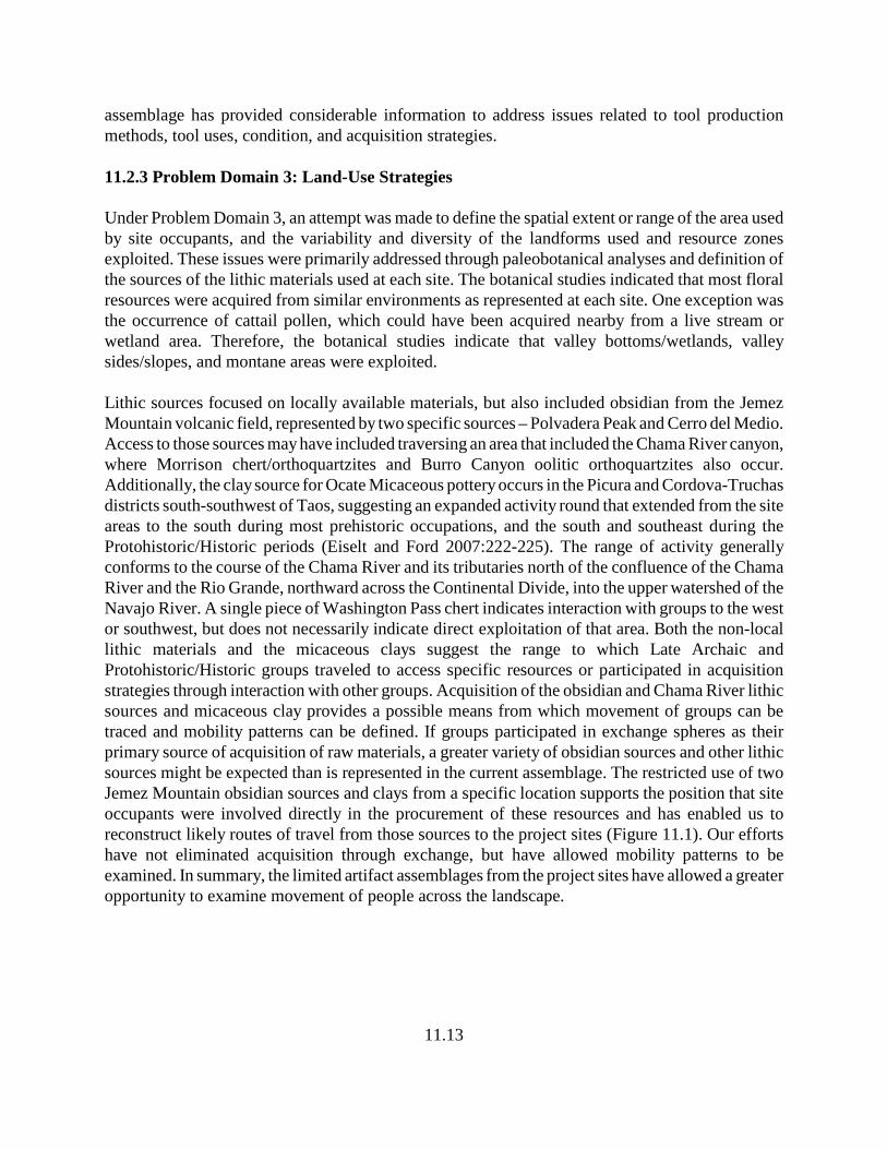
11.13
assemblage has provided considerable information to address issues related to tool productionmethods, tool uses, condition, and acquisition strategies.
11.2.3 Problem Domain 3: Land-Use Strategies
Under Problem Domain 3, an attempt was made to define the spatial extent or range of the area usedby site occupants, and the variability and diversity of the landforms used and resource zonesexploited. These issues were primarily addressed through paleobotanical analyses and definition ofthe sources of the lithic materials used at each site. The botanical studies indicated that most floralresources were acquired from similar environments as represented at each site. One exception wasthe occurrence of cattail pollen, which could have been acquired nearby from a live stream orwetland area. Therefore, the botanical studies indicate that valley bottoms/wetlands, valleysides/slopes, and montane areas were exploited.
Lithic sources focused on locally available materials, but also included obsidian from the JemezMountain volcanic field, represented by two specific sources – Polvadera Peak and Cerro del Medio.Access to those sources may have included traversing an area that included the Chama River canyon,where Morrison chert/orthoquartzites and Burro Canyon oolitic orthoquartzites also occur.Additionally, the clay source for Ocate Micaceous pottery occurs in the Picura and Cordova-Truchasdistricts south-southwest of Taos, suggesting an expanded activity round that extended from the siteareas to the south during most prehistoric occupations, and the south and southeast during theProtohistoric/Historic periods (Eiselt and Ford 2007:222-225). The range of activity generallyconforms to the course of the Chama River and its tributaries north of the confluence of the ChamaRiver and the Rio Grande, northward across the Continental Divide, into the upper watershed of theNavajo River. A single piece of Washington Pass chert indicates interaction with groups to the westor southwest, but does not necessarily indicate direct exploitation of that area. Both the non-locallithic materials and the micaceous clays suggest the range to which Late Archaic andProtohistoric/Historic groups traveled to access specific resources or participated in acquisitionstrategies through interaction with other groups. Acquisition of the obsidian and Chama River lithicsources and micaceous clay provides a possible means from which movement of groups can betraced and mobility patterns can be defined. If groups participated in exchange spheres as theirprimary source of acquisition of raw materials, a greater variety of obsidian sources and other lithicsources might be expected than is represented in the current assemblage. The restricted use of twoJemez Mountain obsidian sources and clays from a specific location supports the position that siteoccupants were involved directly in the procurement of these resources and has enabled us toreconstruct likely routes of travel from those sources to the project sites (Figure 11.1). Our effortshave not eliminated acquisition through exchange, but have allowed mobility patterns to beexamined. In summary, the limited artifact assemblages from the project sites have allowed a greateropportunity to examine movement of people across the landscape.
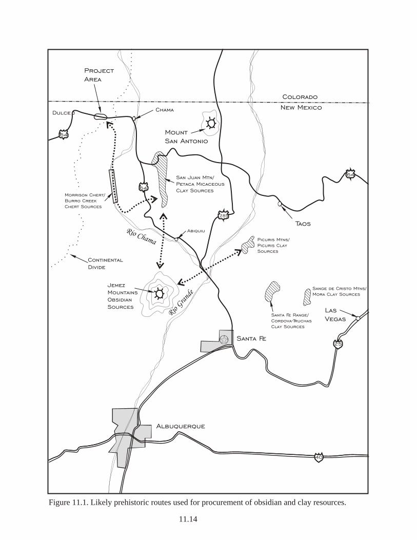
40
64
64
25Santa Fe
Albuquerque
Rio Gra
nde
Rio Chama
64
285
Taos
LasVegas
ContinentalDivide
ProjectArea
Dulce Chama
Colorado
New Mexico
Figure 11.1. Likely prehistoric routes used for procurement of obsidian and clay resources.
11.14
JemezMountainsObsidianSources
San Juan Mtn/Petaca MicaceousClay Sources
Sange de Cristo Mtns/Mora Clay Sources
Santa Fe Range/Cordova-TruchasClay Sources
Picuris Mtns/Picuris Clay Sources
Abiquiu
Mount San Antonio
Morrison Chert/Burro Creek Chert Sources
11.15
11.2.4 Geomorphological Associations and Implications
The research questions posed in regard to defining the geomorphology at each site, defining thecultural/geological associations, and establishing relative temporal associations between the culturaland geologic deposits were very helpful to the overall project interpretations and guidance ofresearch. Each question posed was successfully addressed through Steve Hall’s personal expertiseand the interaction between him and the field staff. The shallow Holocene-age deposits allowed thisproblem domain to be addressed with relative ease. Most importantly, however, Hall was able tocharacterize deposition rates, assess the likelihood of buried (or stratified) deposits, and provide ageestimates of the natural and cultural deposits, which in turn were compared with the archaeologicaland chronometric data gathered for each site. The geomorphological studies were found to beextremely useful and highly informative.
11.2.5 Historic Aboriginal vs. Euroamerican Affiliations
When each of the project sites was initially inspected prior to developing the research design, surfaceindications at Sites LA 133206 and LA 155234 led Four Corners Research personnel to concludethat a strong likelihood existed for the presence of mixed historic Aboriginal andEuroamerican/Hispanic artifact assemblages/occupations. The general area, during the period fromapproximately 1880 until the establishment of the Jicarilla Apache Indian Reservation, may havebeen occupied by Jicarilla Apache in anticipation of the forthcoming reservation. As such, it seemedreasonable to anticipate Jicarilla Apache campsites in the project area and assemblages thatcontained Euroamerican items. The questions posed in the research design are viewed as appropriateto address this issue. Data recovery efforts, however, have demonstrated that, due to limitedaccumulations of deposition, archaeological deposits associated with the Late Archaic and Historicperiods have been mixed at Site LA 133206 and definition of a Protohistoric/Historic aboriginaloccupation was not confirmed. Our efforts have largely resulted in separating the mixed deposits.No indication was found that Historic Aboriginal groups used or acquired Euroamerican goods; noevidence of modification of Euroamerican items was noted and no vernacular or hand-forged itemswere recovered. What was originally thought to be worked glass was later determined to be randomedge damage and unlikely to represent cultural modification.
At Site LA 155234, Protohistoric and Historic deposits occur together in the western portion of thesite. The temporal associations of the Protohistoric deposits, based largely on the period ofproduction of Ocate Micaceous pottery and two radiocarbon dates received from two of the site’sfeatures, predate the historic artifacts by at least 150 years, suggesting that no direct affiliation existsbetween the Protohistoric occupation and the few historic items recovered at the site. Following thetheme of Problem Domain 5, the association between Protohistoric and Late Archaic deposits werealso examined. Protohistoric deposits at Site LA 155234 are mixed with Late Archaic deposits; thenear absence of subsurface artifacts indicates that over a period of 1200 to 1400 years, naturaldeposition did not occur at this site at rates sufficient to separate the two occupationsstratigraphically, resulting in mixed deposits. Aside from the Ocate Micaceous pottery, separatingLate Archaic artifacts from Protohistoric lithics was almost impossible. Hydration studies indicate
11.16
the clustering of mean rind thicknesses at opposite ends of the project analytical spectrum, implyingassociations with the two occupations. The distribution of the Protohistoric ceramics and the twofeatures that produced contemporaneous dates indicate that the Protohistoric occupation extendedacross the entire site area. The spatial extent of the Late Archaic occupation was more difficult todefine, although the projectile points and ground stone artifacts were widely dispersed across the sitealso implying that the entire site area may have been used.
11.3 Sites in a Regional Context
Positioned along the west side of the Continental Divide, the project area lies at an elevation rangeof 7000 to 7500 ft amsl, elevations that afford an insufficient number of days in most years foragriculture. Previous research in the immediate project vicinity has been limited, with few datarecovery efforts completed on comparable studies available. Largely unexplored and unused untilthe early 1880s by Euroamerican interests, the project area became the focus of the Jicarilla Apachebased partly on rumors of the establishment of the Jicarilla Apache Indian Reservation. Prior to thistime, however, increasing pressure from the Comanche on the southern Plains apparently forcedthese Apache toward the Rio Grande and San Juan Mountains (Thomas 1928). Regardless ofchanges in the movement of other groups, including Euroamericans, by 1870, the Jicarilla were notedto occupy land in the Maxwell Land Grant. Later, an early reservation was established near TierraAmarilla in 1874, but relinquished due to objections made by recently established Hispanic settlers.Over the next 13 years, the fate of the Jicarilla Apaches lay largely in the balance, supplied by anunofficial agency in Abiquiu and interacting with groups in the Taos/Picuris areas until the currentreservation was created in 1887. Levine et al. (1996) provide a good review of historic NativeAmerican traditional use areas in the Upper Chama drainage, which illustrates the movement ofgroups into and out of the general project area. These movements altered Jicarilla mobility andresulted in the establishment of new or modified interaction spheres within the Taos and Picuris areaand utilization of lands to the west of the Rio Grande into the Chama region and area north of theSan Juan Basin. Seemingly being pressured farther to the west, Jicarilla Apache sites are foundthroughout the Canjilon area east of the Chama River and in the Gallina cultural area west of theChama River (Eiselt and Ford 2007; Poague et al. 1996; Stuart and Gauthier 1984). Acquisition ofthe horse increased the mobility of the Jicarilla Apache. As Eiselt and Ford (2007:231) point out, theJicarilla Apache were “the only horse nomad society in the northern Rio Grande area to producepottery.” Their mobility and seemingly open relationship with villages provided access to a widevariety of resources. Pottery production became an important component of their exchange system,using all the major clay source districts in the northern Rio Grande. The importance of clay potexchange is emphasized in historic records in which the Jicarilla continued to produce and supplymicaceous pottery to Hispanics and Puebloan groups well into the late 1800s (Eiselt and Ford2007:232). With the establishment of the Jicarilla Reservation in 1877, mobility patterns werereduced to the areas adjacent to the reservation, where some engaged in day labor or wages onneighboring ranches. With this general movement of Jicarilla Apache across northern New Mexico, the likelihood thathistoric Native American groups moved into and used the general project area was considered fairly
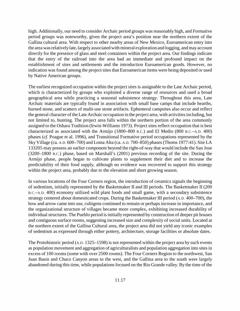
11.17
high. Additionally, our need to consider Archaic period groups was reasonably high, and Formativeperiod groups was noteworthy, given the project area’s position near the northern extent of theGallina cultural area. With respect to other nearby areas of New Mexico, Euroamerican entry intothe area was relatively late, largely associated with mineral exploration and logging, and may accountdirectly for the presence of glass and steel containers within the project area. Our findings indicatethat the entry of the railroad into the area had an immediate and profound impact on theestablishment of sites and settlements and the introduction Euroamerican goods. However, noindication was found among the project sites that Euroamerican items were being deposited or usedby Native American groups.
The earliest recognized occupation within the project sites is assignable to the Late Archaic period,which is characterized by groups who exploited a diverse range of resources and used a broadgeographical area while practicing a seasonal subsistence strategy. Throughout this area, LateArchaic materials are typically found in association with small base camps that include hearths,burned stone, and scatters of multi-use stone artifacts. Ephemeral campsites also occur and reflectthe general character of the Late Archaic occupation in the project area, with activities including, butnot limited to, hunting. The project area falls within the northern portion of the area commonlyassigned to the Oshara Tradition (Irwin-Williams 1973). Project sites reflect occupation that is bestcharacterized as associated with the Armijo (1800–800 B.C.) and El Medio (800 B.C.–A.D. 400)phases (cf. Poague et al. 1996), and Transitional Formative period occupations represented by theSky Village (ca. A.D. 600–700) and Loma Alta (ca. A.D. 700–850) phases (Thoms 1977:41). Site LA133205 may possess an earlier component beyond the right-of-way that would include the San Jose(3200–1800 B.C.) phase, based on Marshall’s (2001) previous recording of the site. During theArmijo phase, people began to cultivate plants to supplement their diet and to increase thepredictability of their food supply, although no evidence was recovered to support this strategywithin the project area, probably due to the elevation and short growing season.
In various locations of the Four Corners region, the introduction of ceramics signals the beginningof sedentism, initially represented by the Basketmaker II and III periods. The Basketmaker II (200B.C.–A.D. 400) economy utilized wild plant foods and small game, with a secondary subsistencestrategy centered about domesticated crops. During the Basketmaker III period (A.D. 400–700), thebow and arrow came into use, cultigens continued to remain or perhaps increase in importance, andthe organizational structure of villages became more complex, exhibiting increased durability ofindividual structures. The Pueblo period is initially represented by construction of deeper pit housesand contiguous surface rooms, suggesting increased size and complexity of social units. Located atthe northern extent of the Gallina Cultural area, the project area did not yield any iconic examplesof sedentism as expressed through either pottery, architecture, storage facilities or absolute dates.
The Protohistoric period (A.D. 1325–1598) is not represented within the project area by such eventsas population movement and aggregation of agriculturalists and population aggregation into sites inexcess of 100 rooms (some with over 2500 rooms). The Four Corners Region to the northwest, SanJuan Basin and Chaco Canyon areas to the west, and the Gallina area to the south were largelyabandoned during this time, while populations focused on the Rio Grande valley. By the time of the
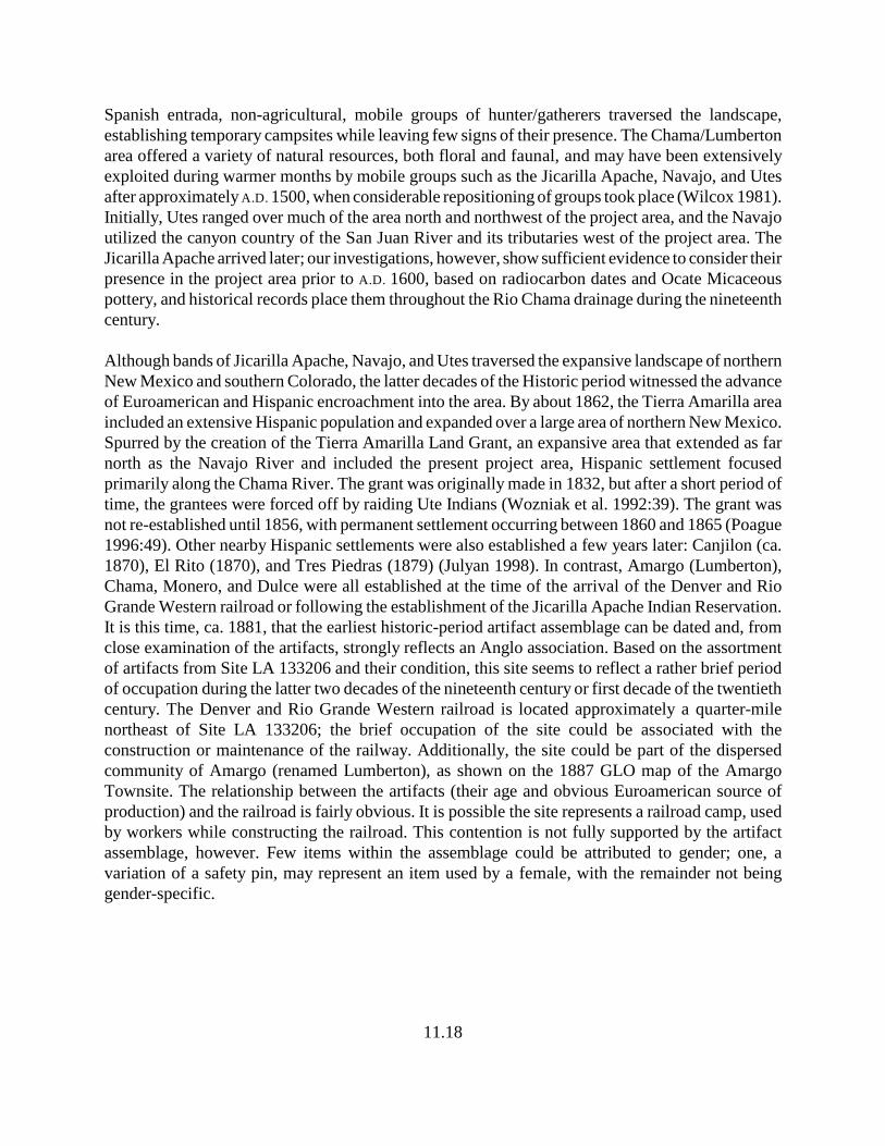
11.18
Spanish entrada, non-agricultural, mobile groups of hunter/gatherers traversed the landscape,establishing temporary campsites while leaving few signs of their presence. The Chama/Lumbertonarea offered a variety of natural resources, both floral and faunal, and may have been extensivelyexploited during warmer months by mobile groups such as the Jicarilla Apache, Navajo, and Utesafter approximately A.D. 1500, when considerable repositioning of groups took place (Wilcox 1981).Initially, Utes ranged over much of the area north and northwest of the project area, and the Navajoutilized the canyon country of the San Juan River and its tributaries west of the project area. TheJicarilla Apache arrived later; our investigations, however, show sufficient evidence to consider theirpresence in the project area prior to A.D. 1600, based on radiocarbon dates and Ocate Micaceouspottery, and historical records place them throughout the Rio Chama drainage during the nineteenthcentury.
Although bands of Jicarilla Apache, Navajo, and Utes traversed the expansive landscape of northernNew Mexico and southern Colorado, the latter decades of the Historic period witnessed the advanceof Euroamerican and Hispanic encroachment into the area. By about 1862, the Tierra Amarilla areaincluded an extensive Hispanic population and expanded over a large area of northern New Mexico.Spurred by the creation of the Tierra Amarilla Land Grant, an expansive area that extended as farnorth as the Navajo River and included the present project area, Hispanic settlement focusedprimarily along the Chama River. The grant was originally made in 1832, but after a short period oftime, the grantees were forced off by raiding Ute Indians (Wozniak et al. 1992:39). The grant wasnot re-established until 1856, with permanent settlement occurring between 1860 and 1865 (Poague1996:49). Other nearby Hispanic settlements were also established a few years later: Canjilon (ca.1870), El Rito (1870), and Tres Piedras (1879) (Julyan 1998). In contrast, Amargo (Lumberton),Chama, Monero, and Dulce were all established at the time of the arrival of the Denver and RioGrande Western railroad or following the establishment of the Jicarilla Apache Indian Reservation.It is this time, ca. 1881, that the earliest historic-period artifact assemblage can be dated and, fromclose examination of the artifacts, strongly reflects an Anglo association. Based on the assortmentof artifacts from Site LA 133206 and their condition, this site seems to reflect a rather brief periodof occupation during the latter two decades of the nineteenth century or first decade of the twentiethcentury. The Denver and Rio Grande Western railroad is located approximately a quarter-milenortheast of Site LA 133206; the brief occupation of the site could be associated with theconstruction or maintenance of the railway. Additionally, the site could be part of the dispersedcommunity of Amargo (renamed Lumberton), as shown on the 1887 GLO map of the AmargoTownsite. The relationship between the artifacts (their age and obvious Euroamerican source ofproduction) and the railroad is fairly obvious. It is possible the site represents a railroad camp, usedby workers while constructing the railroad. This contention is not fully supported by the artifactassemblage, however. Few items within the assemblage could be attributed to gender; one, avariation of a safety pin, may represent an item used by a female, with the remainder not beinggender-specific.
11.19
11.4 Management Recommendations
A program of data recovery was conducted to mitigate the effects of upgrading and widening USHighway 64 through Sites LA 133205 and LA 133206, and constructing new roadway through SiteLA 155234. Efforts at each site within the right-of-way were intensive, first employing grid controls,surface collections and hand excavations of control excavation units, hand stripping units, andfeature excavations. These efforts were followed by mechanically stripping the entire site area withinthe right-of-way or, in the case of Site LA 155234, stripping nearly 90 percent of the site area in thenew right-of-way. Backhoe trenches were also dug to aid geomorphological assessment of the sites.The efforts followed the data recovery plan that was initially reviewed by NMDOT personnel, NMHistoric Preservation Division personnel, and finally by the Cultural Properties Review Committee.Comments received from all three reviews were addressed and implemented under a Project-SpecificPermit (SE-265) for New Mexico State Lands (NMDOT right-of-way acquired from private sources)issued by the Department of Cultural Affairs, Historic Preservation Division, April 24, 2008. Thisreport documents the completion of all proposed recovery, analytical, and reporting responsibilitiesrequired under the Project-Specific Permit, and fulfills the New Mexico Department ofTransportation’s responsibilities in managing these resources in accordance with the currentundertaking. Archaeological deposits with integrity remain beyond the south right-of-way boundaryat Sites LA 133205 and LA 133206. Updated Laboratory of Anthropology Site Record forms, whichdocument the condition of all the project sites, have been completed and submitted with this report.At the request of the Jicarilla Apache Nation and agreed to in a Memorandum of Agreement (MOA)among the Federal Highway Administration, the New Mexico Department of Transportation, andthe New Mexico State Historic Preservation Office, discovered artifacts will be reburied on site oradjacent to a site outside the right-of-way, after all analyses and required documentation have beencompleted. The Federal Highway Administration and New Mexico Department of Transportationwill honor this request by reburying discovered remains within the remaining highway right-of-way(MOA signed into effect February 25, 2008).
12.1
12.0 REFERENCES CITED
Angell, Madeline1981 A Field Guide to Berries and Berrylike Fruits. The Bobbs-Merrill Company, Inc.,
New York.
Angier, Bradford1978 Field Guide to Medicinal Wild Plants. Stackpole Books, Harrisburg.
Anschuetz, Kurt F.1992 Saving for a Rainy Day: The Integration of Diverse Agricultural Technologies to
Harvest and Conserve Water in the Lower Rio Chama Valley, New Mexico. Paperpresented at the New Mexico Archaeological and Agricultural Symposium, October2-4, 1992, BLM State Land Office, Santa Fe.
Antevs, Ernst 1955 Geologic-Climatic Dating in the West. American Antiquity 20(4):317-335.
Athearn, Frederic J.1989 A Forgotten Kingdom: The Spanish Frontier in Colorado and New Mexico 1540-
1821. Cultural Resource Series Number 29. Bureau of Land Management,Colorado State Office, Lakewood.
Bamforth, Douglas1986 Technological Efficiency and Tool Curation. American Antiquity 51:38-50.
Bartlett, Katharine1933 Pueblo Milling Stones of the Flagstaff Region and Their Relation to Others in the
Southwest. Museum of Northern Arizona Bulletin No. 3. Flagstaff.
Beaumont, E. C., and C. B. Read, eds. 1960 New Mexico Geological Society Eleventh Field Conference, Rio Chama Country.
Bever, Michael R.2006 Too Little, Too Late? The Radiocarbon Chronology of Alaska and the Peopling of
the New World. American Antiquity 71(4):595-620.
Bohrer Vorsila L.1975 The Prehistoric and Historic Role of the Cool-Season Grasses in the Southwest.
Economic Botany 29:199-207.
12.2
Brown, Gary M., and Patricia M. Hancock1992 The Dinetah Phase in the La Plata Valley. In Cultural Diversity and Adaptation:
The Archaic, Anasazi, and Navajo Occupation of the Upper San Juan Basin, editedby Lori Stephens Reed and Paul F. Reed, pp. 69-90. Cultural Resources Series No.9. USDI Bureau of Land Management, Santa Fe.
Bryan, Nonabah G. and Stella Young1978 Navajo Native Dyes: Their Preparation and Use. Chilocco Agricultural School,
Chilocco, Oklahoma.
Castetter, Edward F.1935 Ethnobiological Studies in the American Southwest: I. Uncultivated Native Plants
Used as Sources of Food. The University of New Mexico Bulletin 266 4(1).
Castetter, Edward F. and William H. Bell1942 Pima and Papago Indian Agriculture. University of New Mexico Press,
Albuquerque.
Chamberlin, Ralph V.1964 The Ethnobotany of the Gosiute Indians of Utah. In American Anthropological
Association Memoirs 2, pp. 329-405. Kraus Reprint Corp., New York.
Chronic, Halka1983 Roadside Geology of Arizona. Mountain Press Publishing Co., Missoula.
Colton, Harold S.1974 Hopi History and Ethnobotany. In Hopi Indians, pp. 279-424. Garland Publishing
Inc., New York.
Curtin, L. S. M.1984 By the Prophet of the Earth. University of Arizona Press, Tucson.
Cushing, Frank Hamilton1920 Zuni Breadstuff. In Indian Notes and Monographs, vol. VIII. Heye Foundation,
New York.
Dick, H. W. 1976 Archeological Excavations in the Llaves Area, Santa Fe National Forest, New
Mexico, 1972-1974, Part 1 - Architecture. USDA Forest Service SouthwesternRegion Archeological Report No. 13.
12.3
1980 Cohesive and Dispersive Configurations in Settlement Patterns of the NorthernAnasazi: A Hypothesis. In Papers of the Archaeological Society of New Mexico,edited by Albert Schroeder and James Bain, 5:57-82. Collected Papers in Honor ofHelen Greene Blumenschein.
Dick-Peddie, William A. 1993 New Mexico Vegetation Past and Present. University of New Mexico Press,
Albuquerque.
Ebeling, Walter1986 Handbook of Indian Foods and Fibers of Arid America. University of California
Press, Berkeley.
Eidenbach, Peter L. 1983 The Prehistory of Rhodes Canyon, New Mexico. Human Systems Research, Inc.,
Tularosa.
1990 Pot Gathering and Bottle Hunting—Anecdotes on Apache Archaeology in South-central New Mexico. Chiricahua and Mescalero Apache Conference, Truth orConsequences, New Mexico, November 9-10, 1990.
Eiselt, B. Sunday, and Richard I. Ford2007 Sangre de Cristo Micaceous Clays: Geochemical Indices for Source and Raw
Material Distribution, Past and Present. Kiva 73(2):219-238.
Ellis, F. H. 1988 From Drought to Drought: An Archaeological Record of Life Patterns as
Developed by the Gallina Indians of North Central New Mexico (A.D. 1050-1300)Volume I Canjilon Mountain: Hunting and Gathering Sites. Sunstone Press, SantaFe.
Elmore, Francis H.1944 Ethnobotany of the Navajo. University of New Mexico with the School of
American Research, Santa Fe.
Fenneman, Nevin M. 1931 Physiography of the Western United States. McGraw-Hill, New York.
Fiedel, Stuart J.1999 Older Than We Thought: Implications of Corrected Dates for Paleoindians.
American Antiquity 64(1):95-116.
12.4
Findlow, Frank J., and Marisa Bolognese1982 Regional Modeling of Obsidian Procurement in the American Southwest. In
Contexts for Prehistoric Exchange. Academic Press, Inc.
Fish, Suzanne K., and Charles Miksicek 1982 Sampling Guidelines for Pollen and Flotation. In Hohokam Archaeology along the
Salt-Gila Aqueduct, Central Arizona Project: Research Design, edited by Lynn S.Teague and Patricia L. Crown, pp. 169-173. Arizona State Museum ArchaeologicalSeries No. 150, Vol 1. University of Arizona, Tucson.
Fowler, Catherine S.1989 Willard Z. Park=s Ethnographic Notes on the Northern Paiute of Western Nevada,
1933-1944. University of Utah Anthropological Papers Number 114 1. Universityof Utah Press, Salt Lake City.
Fox, Anne A.1989 Historic Anglo-European Exploration and Colonization. In From the Gulf to the Rio
Grande: Human Adaptation in Central, South, and Lower Pecos Texas, by ThomasR. Hester, Stephen L. Black, D. Gentry Steele, Ben W. Olive, Anne A. Fox, Karl J.Reinhard, and Leland C. Bement, pp. 85-92. Arkansas Archeological SurveyResearch Series No. 33. Center for Archaeological Research at the University ofTexas at San Antonia, Texas A & M University, and the Arkansas ArcheologicalSurvey.
Gallagher, Marsha V.1977 Contemporary Ethnobotany Among the Apache of the Clarkdale, Arizona Area
Coconino and Prescott National Forests. USDA Forest Service, Southwest Region,Albuquerque.
Gilpin, Dennis 1993 Historical Archaeology on the Navajo Indian Irrigation Project. In DÀA'ÀK'EH
NITSAA: An Overview of the Cultural Resources of the Navajo Indian IrrigationProject, Northwestern New Mexico, by Lawrence E. Vogler, Kristin Langenfeld,and Dennis Gilpin, pp. 191-281. Navajo Nation Papers in Anthropology No. 29.Navajo Nation Archaeology Department, Window Rock.
Gossett, Bill, and Peter L. Eidenbach1980 An Evaluation of Cultural Resources Potentially Affected by Proposed Highway
Improvements along the Cloudcroft to Sunspot Road (FR 64), Lincoln NationalForest, New Mexico. Human Systems Research, Inc., Tularosa.
12.5
Greenwald, David H.2008 Data Recovery Plan for Three Sites along US 64, East of Lumberton, Rio Arriba
County, New Mexico. Prepared for the New Mexico Department of Transportation,Cultural Resources Program, Environmental Section. Prepared under ConsultantTask No 4999-4. Four Corners Research Report 278-4-1, Tularosa.
Greenwald, Dawn M.1990 A Functional Evaluation of Hohokam Food Grinding Systems. Unpublished
Master=s thesis, Department of Anthropology, Northern Arizona University,Flagstaff.
1993a The Utilization of Ground Stone at Sites along the Coronado Railroad. In TheCoronado Project: Anasazi Settlements Overlooking the Puerco Valley, Arizona,vol. 2, pp. 93-126, edited by Richard V. N. Ahlstrom, Marianne Marek, and DavidH. Greenwald. SWCA Anthropological Research Paper No. 3, Flagstaff andTucson.
1993b Ground Stone Artifacts from La Ciudad de Los Hornos. In In the Shadow of SouthMountain: The Pre-Classic Hohokam of La Ciudad de Los Hornos, 1991-1992Excavations, Part I, pp. 317-358, edited by Mark L. Chenault, Richard V. N.Ahlstrom, and Thomas N. Motsinger. SWCA Environmental ConsultantsArchaeological Report No. 93-30, Tucson.
1997 Ground Stone and Flaked Stone Analysis. In Report on Archaeological Testing andProposal for Data Recovery along Navajo Route 9(5-1), McKinley County, NewMexico, by David A. Phillips, Jr., Dennis Gilpin, and Richard A. Anduze, pp. 154-172. SWCA Archaeological Report No. 97-50. SWCA, Inc., EnvironmentalConsultants, Flagstaff.
Gunnerson, Dolores A. 2006 Apache History and Jicarilla Origins, 1525-1801. J & L Lee Co., Lincoln.
Gunnerson, James H. 1969 Apache Archaeology in Northeastern New Mexico. American Antiquity 34:23-39.
1987 Archaeology of the High Plains. BLM Colorado Cultural Resource Series Number19:114, Denver.
Halbirt, Carl D.1985 Pollen Analysis of Metate Wash Samples: Evaluating Techniques for Determining
Metate Function. Unpublished Master=s thesis, Department of Anthropology,Northern Arizona University, Flagstaff.
12.6
Hammack, Laurens C.1965 Archaeology of the Ute Dam and Reservoir. Papers in Anthropology Number 14.
Museum of New Mexico Press, Santa Fe.
Hard, Robert J.1988 The Emergence of Farming Economies in the American Southwest. Paper
presented at the 53 Annual Meeting of the Society for American Archaeology,rd
Phoenix.
Harrington, H. D.1964 Manual of the Plants of Colorado. Sage Books, Chicago.
1967 Edible Native Plants of the Rocky Mountains. University of New Mexico Press,Albuquerque.
1972 Western Edible Wild Plants. The University of New Mexico Press, Albuquerque.
Hodge, Frederick W.1960 Handbook of American Indians North of Mexico, Bureau of American Ethnology
Bulletin 30 (1905), Smithsonian Institution, Washington, D.C. Pageant Books, NewYork.
Irwin-Williams, Cynthia1973 The Oshara Tradition: Origins of Anasazi Culture. Eastern New Mexico University
Contributions in Anthropology 5(1), Portales.
Jennings, Jesse D.1980 Introduction. In Sudden Shelter. By Jesse D. Jennings, Alan R. Schroedl, and
Richard N. Holmer, pp. 3-23. University of Utah Anthropological Papers No. 103.University of Utah Press, Salt Lake City.
1986 Prehistory: Introduction. Handbook of North American Indians: Great Basin. Vol.11, edited by Warren L. D=Azevedo. Smithsonian Institution, Washington, D. C.
Jones, George T., Charlotte Beck, Eric E. Jones, and Richard E. Hughes2003 Lithic Source Use and Paleoarchaic Foraging Territories in the Great Basin.
American Antiquity 68:5-38.
Julyan, Robert1998 The Place Names of New Mexico. University of New Mexico Press, Albuquerque.
12.7
Justice, Oren L. and Louis N. Bass1978 Principles and Practices of Seed Storage. Agriculture Handbook ed. 506. U.S.
Department of Agriculture, Washington, D.C.
Kearney, Thomas H. and Robert H. Peebles1960 Arizona Flora. University of California Press, Berkeley.
Kelley, Shari A.2008 H e r o n L a k e S t a t e P a r k . E l e c t r o n i c d o c u m e n t ,
http://geoinfo.nmt.edu/tour/state/heron_lake/home.html, accessed November 26,2008.
Kirk, Donald R.1975 Wild Edible Plants of Western North America. Naturegraph Publishers, Happy
Camp, California.
Krochmal, Arnold and Connie Krochmal1973 A Guide to the Medicinal Plants of the United States. Quadrangle, the New York
Times Book Co., New York.
Kuru=es, Bettina, Jalesa Johnson, and Stephen W. Yost2007 Cultural Resource Survey of 105.12 Hectares (260 Acres) along US Highway 64
from Milepost 140 to Milepost 148.7, and around the Intersection of US Highway64 and US Highway 84 in Rio Arriba County, New Mexico. EMI Report Number716. Ecosystems Management, Inc., Albuquerque.
Lamb, Samuel H.1989 Woody Plants of the Southwest. Sunstone Press, Santa Fe.
Leonhardy, Frank C., and Vickie L. Clay1985 Bedrock Geology, Quaternary Stratigraphy, and Geomorphology. In Dolores
Archaeological Program: Studies in Environmental Archaeology, compiled byKenneth Lee Petersen, Vickie L. Clay, Meredith H. Matthews, and Sarah W.Neusius, pp. 131-138. U.S. Department of the Interior, Bureau of Reclamation.
Levine, Frances, Kristi Catanach, and Juan B. Manchego1996 Historic Native American Use of the Upper Chama Drainage. In Cultural Resource
Overview and Class III Survey of El Vado Reservoir, Rio Arriba County, NewMexico, by Wendy Jones Poague, Kristen D. Martine, and David A. Phillips, Jr.,pp. 31-41. SWCA Archaeological Report No. 95-55, Albuquerque.
12.8
Lockhart, Bill2003 Pre-Prohibition Beer Dating Chart Adapted by Bill Lockhart 2003. Unpublished
Cheat Sheet for Historic Glass.
2004 The Dating Game: Owens-Illinois Glass Co. Bottles and Extras 15(3):22-27.
Lovis, William A., Randolph E. Donahue, and Margaret B. Holman2005 Long-Distance Logistic Mobility as an Organizing Principle among Northern
Hunter-Gatherers: A Great Lakes Middle Holocene Settlement System. AmericanAntiquity 70:669-694.
Loy, Thomas H., and E. James Dixon1998 Blood Residues on Fluted Points from Eastern Beringia. American Antiquity
63(1):21-46.
Lucas, S. G., K. E. Zeigler, V. W. Lueth, and D. E. Owen, editors2005 Geology of the Chama Basin. New Mexico Geological Society Fall Conference
Guidebook 56. New Mexico Geological Society, Socorro.
Mackey, J. C. and S. J. Holbrook1978 Environmental Reconstruction and the Abandonment of the Largo-Gallina Area,
New Mexico. Journal of Field Archaeology 5:29-49.
Manley, Kim, Glenn R. Scott, and Reinhard A. Wobus1987 Geologic Map of the Aztec 1E H 2E Quadrangle, Northwestern New Mexico and
Southern Colorado. Miscellaneous Investigations Series, MAP 1-1730. U.S.Geological Survey, Department of the Interior, Washington, D.C.
Marshall, Michael P. 2001 A Cultural Resource Survey for the US 64 Fencing Projects at Lumberton-Monero
and Tierra Amarilla East, Rio Arriba County, New Mexico. Cibola ResearchConsultants Report No. 288, Corrales.
Martin, Alexander C. and William D. Barkley1961 Seed Identification Manual. University of California, Berkeley.
Matthews, Meredith H.1979 Soil Sample Analysis of 5MT2148: Dominguez Ruin, Dolores, Colorado. Appendix
B. In The Dominguez Ruin: A McElmo Phase Pueblo in Southwestern Colorado,edited by A. D. Reed. Bureau of Land Management Cultural Resource Series, Vol.7. Bureau of Land Management, Denver.
12.9
Mauldin, Raymon P.1993 The Relationship Between Ground Stone and Agricultural Intensification in
Western New Mexico. The Kiva 58:317-330.
Mercer, Jean Ann, and Jean H. Ballagh 1996 Ethnohistory of Hackberry: A Hualapai Perspective. In The Historic Hualapai
Occupation at Hackberry, Mohave County, Arizona: Archival, Ethnohistoric, andArchaeological Investigations by David E. Purcell, pp. 49-56. SWCAArchaeological Report No. 94-155, Flagstaff.
Minnis, Paul E.1981 Seeds in Archaeological Sites: Sources and Some Interpretive Problems. American
Antiquity 46(1):143-152.
Moerman, Daniel E.1986 Medicinal Plants of Native America. University of Michigan Museum of
Anthropology Technical Reports No. 19, 1 and 2. University of Michigan Press,Ann Arbor.
1998 Native American Ethnobotany. Timber Press, Portland, Oregon.
Mooney, James1898 The Jicarilla Genesis. American Anthropologist, Vol. XI, No. 7.
Moore, Michael1990 Los Remedios: Traditional Herbal Remedies of the Southwest. Red Crane Books,
Santa Fe.
Muehlberger, W. R. 1967 Geology of the Chama Quadrangle, New Mexico. New Mexico Bureau of Geology
and Mineral Resources Bulletin 89.
Musil, Albina F.1963 Identification of Crop and Weed Seeds. Agricultural Handbook no. 219. U.S.
Department of Agriculture, Washington, D.C.
National Park Service (NPS) Staff Document2008 Chaco Culture National Historic Park: Geology. Document available online at:
http://www.nps.gov/archive/chcu/geology.htm.
12.10
Natural Resource Conservation Service (NRCS) Staff Document 2008 Custom Soil Resource Report for Rio Arriba Area, New Mexico, Parts of Rio
Arriba and Sandoval Counties, Document available online at:http://websoilsurvey.nrcs.usda.gov/app/
Neusius, Phillip D.1988 Functional Analysis of Selected Flaked Lithic Assemblages from the Dolores River
Valley: A Low-power Microwear Approach. In Dolores Archaeological ProgramSupporting Studies: Additive and Reductive Technologies, edited by Eric Blinman,Carl J. Phagan, and Richard H. Wilshusen, pp. 209-282. U.S. Department of theInterior, Washington, D.C.
New Mexico Bureau of Geology and Mineral Resources2003 Geologic Map of New Mexico. New Mexico Bureau of Geology and Mineral
Resources, Socorro (2 sheets, scale 1:500,000).
New Mexico Cultural Resource Information System1993 User’s Guide: New Mexico Cultural Resource Information System, Guidelines for
Submitting Archeological Records. State of New Mexico, Office of CulturalAffairs, Historic Preservation Division, Archeological Records ManagementSection. Santa Fe.
Niethammer, Carolyn1974 American Indian Food and Lore. Collier Brooks, New York.
Northwest Research Obsidian Studies Laboratory2008 Introduction to Obsidian Hydration Studies. Electronic document,
http://www.obsidianlab.com/info_oh.html, accessed December 30, 2008.
Okun, Adam S., and David H. Greenwald2007 Prehistoric and Historic Land Use in the Canjilon Watershed: Canjilon Wildland
Urban Interface (WUI) Project Archaeological Survey, Carson National Forest,Rio Arriba County, New Mexico. Four Corners Research Report No. 06-277,Tularosa.
O=Mack, Scott 2005 Historical-Period Artifacts. In Fence Lake Project: Archaeological Data Recovery
in the New Mexico Transportation Corridor and First Five-Year Permit Area,Fence Lake Coal Mine Project, Catron County, New Mexico, edited by Edgar K.Huber and Carla R. Van West, pp. 25.1-139 Volume 2: Material Culture Studies.Technical Series 84. Statistical Research, Inc., Tucson.
12.11
Opler, Morris E.1936 A Summary of Jicarilla Apache Culture. American Anthropologist 38:202-223.
Orcutt, Janet D., and Genevieve N. Head2002 Summary and Conclusions. In From Folsom to Fogelson: The Cultural Resources
Inventory Survey of Pecos National Historical Park: Volume 2, edited byGenevieve N. Head and Janet D. Orcutt, pp. 421-433. Intermountain CulturalResources Management Professional Paper No. 66. U.S. Department of the InteriorNational Park Service, Intermountain Support Office, Anthropology Projects, SantaFe.
Overdier, Timothy R. 2004 Soil Survey of Jicarilla Apache Nation, New Mexico, Parts of Rio Arriba and
Sandoval Counties. Published jointly by the USDA, NRCS, BIA, and NMAES.Document available online at: http://websoilsurvey.nrcs.usda.gov/app/
Patterson, L. W.1982 The Importance of Flake Size Distribution. Contract Abstracts and Cultural
Resource Management Archaeology 3(1):70-72.
Perkins, D., Jr., and P. Daly1968 A Hunter=s Village in Neolithic Turkey. Scientific American 219(5):96-106.
Petrides, George A., and Olivia Petrides1992 A Field Guide to Western Trees. The Peterson Field Guide Series. Houghton
Mifflin Co., Boston.
Phagan, Carl J., and T. Homer Hruby1984 Reductive technologies manual: preliminary analysis systems and procedures.
Dolores Archaeological Program Technical Reports DAP-150. Submitted to theBureau of Reclamation, Upper Colorado Region, Salt Lake City.
Plog, Fred, George J. Gumerman, Robert C. Euler, Jeffrey S. Dean, Richard H. Hevly, and ThorN. V. Karlstrom
1988 Anasazi Adaptive Strategies: the Model, Predictions, and Results. In The Anasazi ina Changing Environment, edited by George J. Gumerman, pp. 230-276. School ofAmerican Research Advanced Seminar Series, Cambridge University Press.
Poague, Wendy Jones, Kristen D. Martine, and David A. Phillips, Jr. 1996 Cultural Resource Overview and Class III Survey of El Vado Reservoir, Rio Arriba
County, New Mexico. SWCA Archaeological Report No. 95-55, Albuquerque.
12.12
Powell, Melissa S.2002 Ceramics. In From Folsom to Fogelson: The Cultural Resources Inventory Survey
of Pecos National Historical Park: Volume 1, edited by Genevieve N. Head andJanet D. Orcutt, pp. 237-303. Intermountain Cultural Resources ManagementProfessional Paper No. 66. U. S. Department of the Interior National Park Service,Intermountain Support Office, Anthropology Projects, Santa Fe.
Purcell, David E.1996 The Historic Hualapai Occupation at Hackberry, Mohave County, Arizona:
Archival, Ethnohistorical, and Archaeological Investigations. SWCAArchaeological Report No. 94-155, Flagstaff.
Puseman, Kathryn2001 Examination of Charcoal from the Black Mountain Folsom Site (5MN55),
Colorado. PRI Technical Report 01-76. Ms. on file, Great Sand Dunes NationalMonument, Mosca, Colorado.
Quick, Clarence R.1961 How Long Can a Seed Remain Alive? In Seeds, the Yearbook of Agriculture, edited
by A. Stefferud, pp. 94-99. U.S. Government Printing Office, Washington, D.C.
Robbins, W. W., J. P. Harrington and Barbara Freire-Marreco1916 Ethnobotany of the Tewa Indians. Bureau of American Ethnology Bulletin 55.
Robinson, Linda2008 O b s i d i a n H y d r a t i o n . E l e c t r o n i c d o c u m e n t ,
http://www.mnsu.edu/emuseum/archaeology/dating/dat_obsid.html, accessedDecember 30, 2008.
Scarborough, V. L.1989 Site Structure of a Village of the Late Pithouse-Early Pueblo Period in New
Mexico, Journal of Field Archaeology 16 (4):405-425.
Schopmeyer, C. S.1974 Seeds of Woody Plants in the United States. Agricultural Handbook No. 450. U.S.
Department of Agriculture, Washington, D.C.
Sebastian, Lynne, and Frances Levine1989 The Mexican and American Historical Periods. In Living on the Land: 11,000 Years
of Human Adaptation in Southeastern New Mexico, by Lynne Sebastian and SignaLarralde, pp. 105-126. New Mexico Bureau of Land Management Cultural
12.13
Resource Series No. 6. Office of Contract Archeology, University of New Mexico,Albuquerque.
Seymour, Deni J.2002 Conquest and Concealment: After the El Paso Phase on Fort Bliss: An
Archaeological Study of the Manso, Suma, and Early Apache. Lone MountainReport No. 525/528. Lone Mountain Archaeological Services, Inc., El Paso.
Smith, Anne M.1974 Ethnography of the Northern Utes. Papers in Anthropology 17. Museum of New
Mexico Press, Albuquerque.
South, Stanley 1977 Method and Theory in Historical Archaeology. Academic Press, New York.
Spurr, Kimberly, and Dawn M. Greenwald1995 Flaked Stone Analysis. In The Sky Harbor Project: Early Desert Farming and
Irrigation Settlements, Archaeological Investigations in the Phoenix Sky HarborCenter, vol. 3: Pueblo Salado, pp. 187-224, edited and compiled by David H.Greenwald, Mark L. Chenault, and Dawn M. Greenwald. SWCA AnthropologicalResearch Paper No. 4, Flagstaff and Tucson.
Stone, Tammy1994 The Impact of Raw-Material Scarcity on Ground-Stone Manufacture and Use: An
Example from the Phoenix Basin Hohokam. American Antiquity 59:680-694.
Stuart, David E., and Rory P. Gauthier1984 Prehistoric New Mexico: Background for Survey. Historic Preservation Bureau,
Santa Fe.
Sullivan, Alan P., III, and Kenneth C. Rozen1985 Debitage Analysis and Archaeological Interpretation. American Antiquity 50:755-
779.
The Regents of the University of California2008 Chronological Methods 10-Obsidian Hydration Dating. Electronic document,
http://idarchserve.usb.edu/Anth3/courseware/chronology/10_Obsidian_Hydrationl.-html, accessed December 30, 2008.
Thomas, Alfred Barnaby1928 Spanish Exploration of Oklahoma 1599-1792. Chronicles of Oklahoma, Volume 6,
No. 2.
12.14
1966 After Coronado: Spanish Exploration Northeast of New Mexico, 1696-1727.Documents from the Archives of Spain, Mexico, and New Mexico. Translated andedited by Alfred Barnaby Thomas.
Thoms, Alston Vern1977 A Preliminary Projectile Point Typology for the Southern Portion of the Northern
Rio Grande Region, New Mexico. Unpublished Master=s thesis, Department ofAnthropology, Texas Tech University.
Tilford, Gregory L.1997 Edible and Medicinal Plants of the West. Mountain Press Publishing Company,
Missoula, Montana.
Tiller, Veronica E. Velarde1983 The Jicarilla Apache Tribe: A History. University of Nebraska Press, Lincoln.
Vaughn, John H.1923 History and Government of New Mexico. Self published, State College, Las Cruces.
Vélez de Escalante, Silvestre 2008 Diary and Itinerary. In The Story of the Escalante Expedition to the Interior Basin,
1776, edited and translated by Herbert E. Bolton, pp. 133-239, Utah HistoricalSociety, Salt Lake City (1950). Online facsimile edition atwww.americanjourney.org/af-106, accessed December 2008.
Vestal, Paul A.1952 The Ethnobotany of the Ramah Navaho. Papers of the Peabody Museum of
American Archaeology and Ethnology 40(4). Harvard University, Cambridge.
Vines, Robert A.1960 Trees, Shrubs, and Woody Vines of the Southwest. University of Texas Press,
Austin.
Waters, Michael R., and Thomas W. Stafford, Jr.2007 Redefining the Age of Clovis: Implications for the Peopling of the Americas.
Science Vol. 315:1122-1126.
Wheat, Carl I.1957 Mapping the Transmississippi West—1540-1861 (six volumes). The Institute of
Historical Cartography, San Francisco.
12.15
Whiting, Alfred F.1939 Ethnobotany of the Hopi. Museum of Northern Arizona Bulletin 15.
Wilcox, David R.1981 The Entry of Athapaskans into the American Southwest: The Problem Today. In
The Protohistoric Period in the North American Southwest, A.D. 1450-1700, editedby David R. Wilcox and W. Bruce Masse, pp. 378-409 Arizona State UniversityAnthropological Research Papers No. 24, Tempe.
Williams, Pierce1932 The Purchase of Medical Care Through Fixed Periodic Payment. National Bureau
of Economic Research Publication No. 20. National Bureau of Economic Research,Inc., New York.
Wimberly, Mark, and Peter L. Eidenbach 1981 Preliminary Analysis of Faunal Remains from Fresnal Shelter, New Mexico:
Evidence of Differential Butchering Practices during the Archaic Period (with MarkWimberly, posthumous). In Archaeological Essays in Honor of Mark Wimberly.The Artifact, Vol. 15. El Paso Archaeological Society.
Wozniak, Frank, Meade F. Kemrer, and Charles M. Carrillo1992 History and Ethnohistory Along the Rio Chama. U.S. Army Corps of Engineers,
Albuquerque.

APPENDIX A:
LOCATIONAL MAPS
APPENDIX B:
RADIOCARBON DATING ANALYSES
by
Dr. M. A. Tamers and Mr. D. G. HoodBeta Analytic, Inc.
Miami, Florida
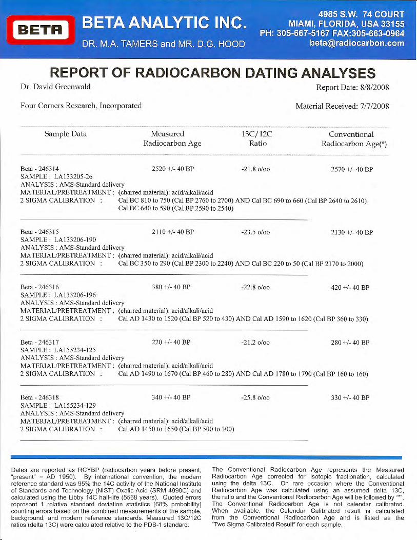
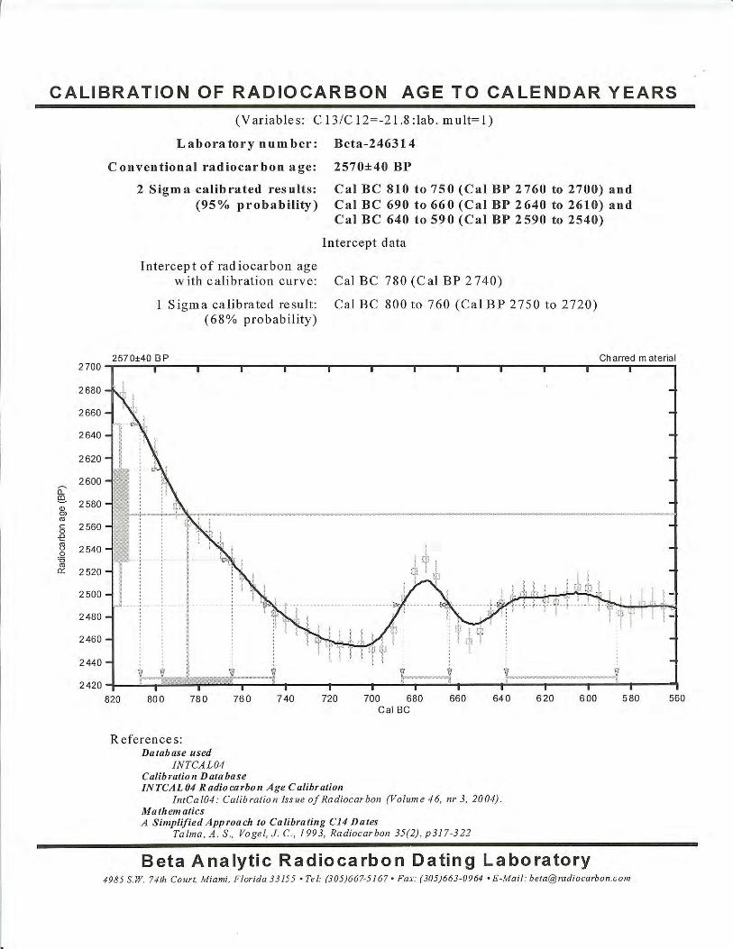
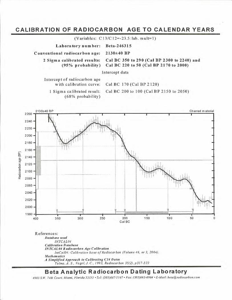
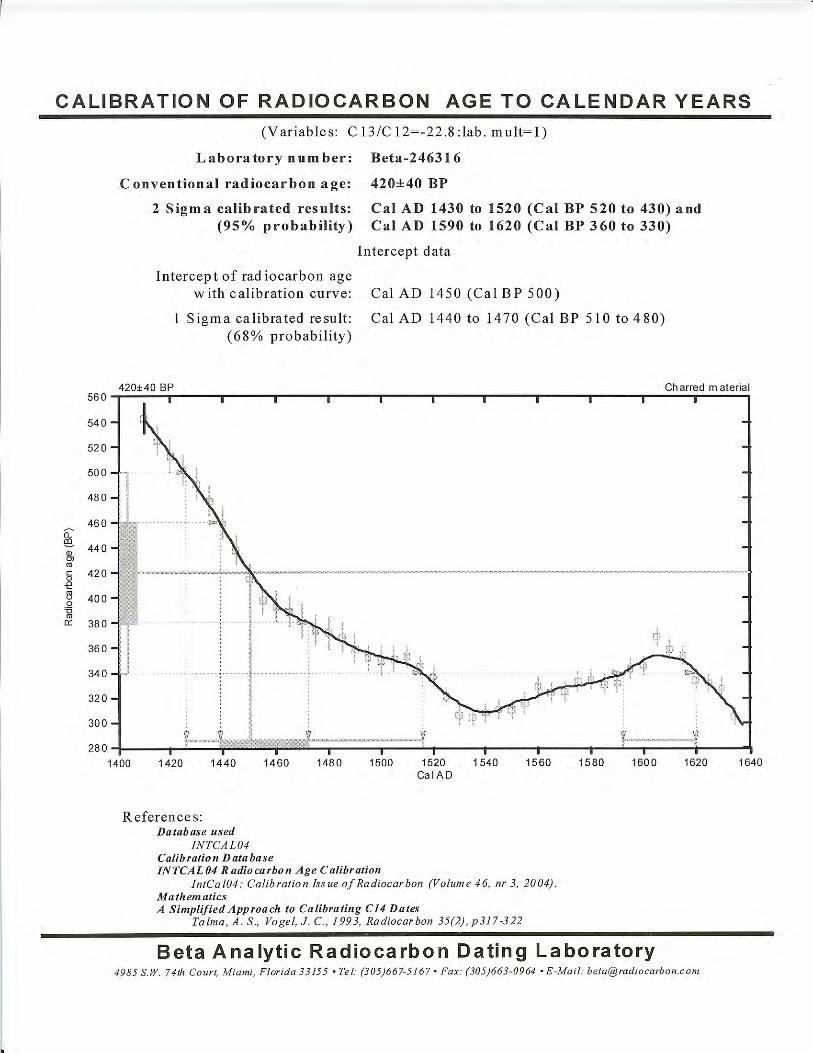
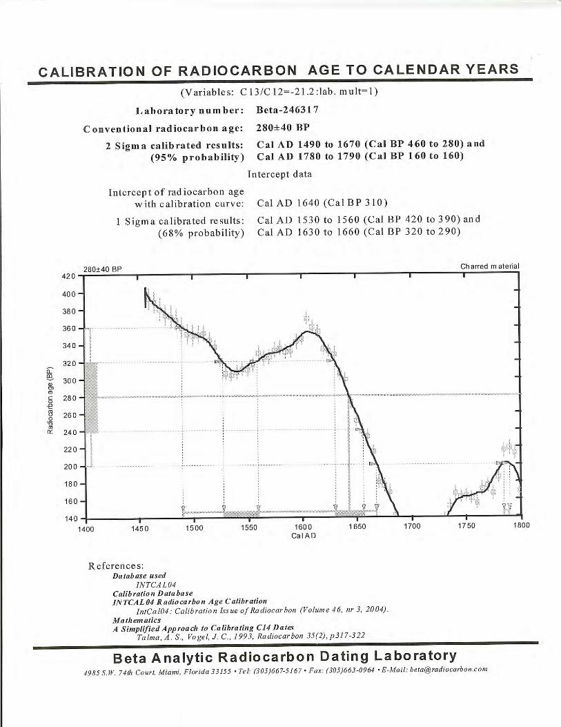
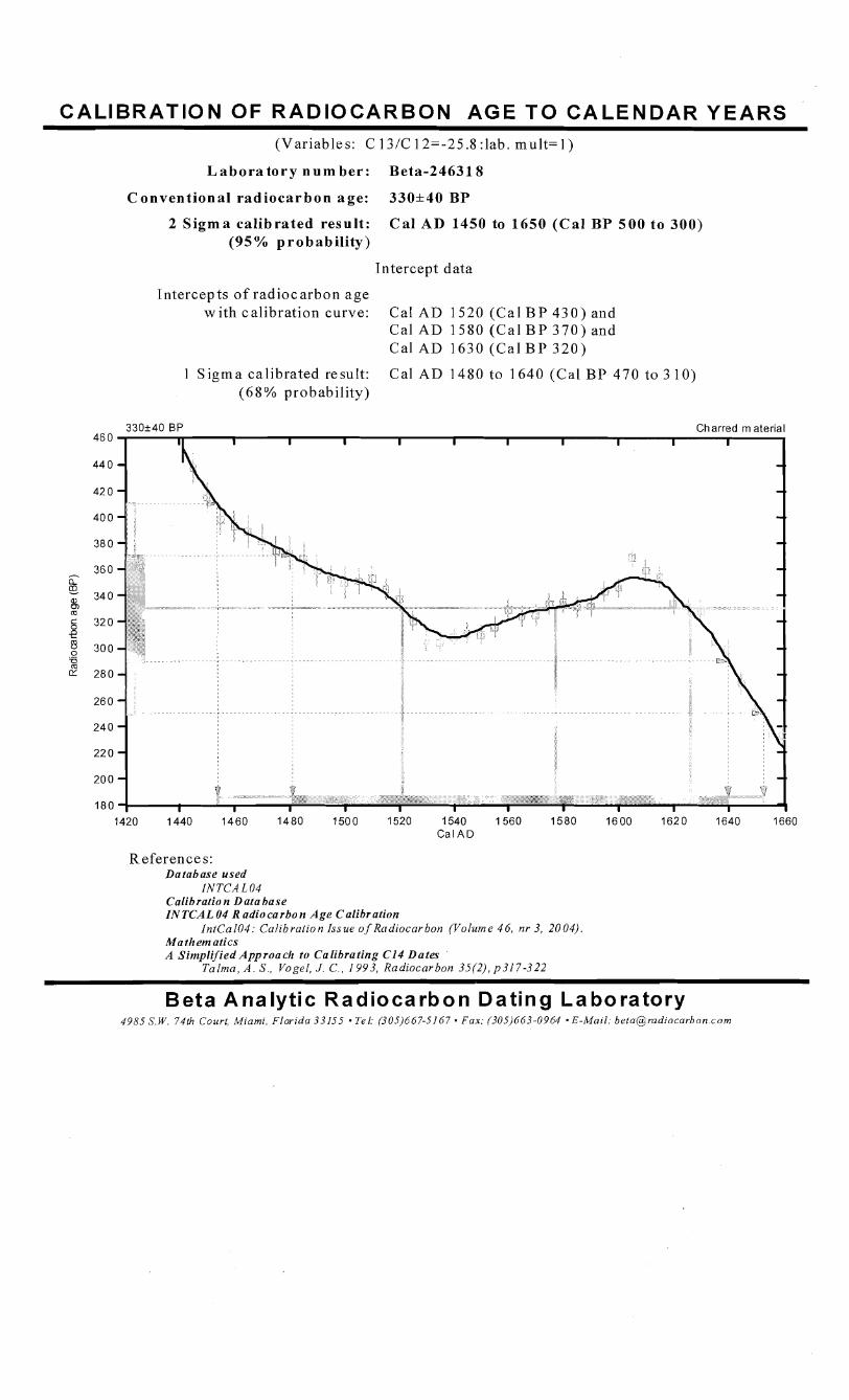
CALIBRATION OF RADIOCARBON AGE T O CALENDAR YEARS (Variables: C 13/C 12=-25.8 :lab. m u l t = l )
L a b o r a t o r y n u m b e r : Beta-24631 8
C o n v e n t i o n a l r a d i o c a r b o n age : 330*40 B P
2 S i g m a ca l ib ra ted resul t : C a l AD 1450 to 1650 ( C a l B P 5 0 0 t o 300) (95% p r o b a b i l i t y )
Intercept data
Intercepts o f radiocarbon age wi th calibration curve: Cal AD 1520 (Cal B P 4 3 0 ) and
Cal A D 1580 (Ca l B P 3 7 0 ) and Cal A D 1630 (Ca l B P 3 2 0 )
1 Sigma calibrated result: Cal A D 1480 to 1640 (Cal B P 470 to 3 10) (68% probability)
1420 1440 1460 1480 1500 1520 1540 1560 1580 1600 1620 1640 1660 Cal A D
References: Database used
INTCA L 04 Calibration Data base IN TCAL 04 R adio carbo n Age Calibration
In tCal04: Calibration Issue o f Radiocarbon (Volume 4 6 , nr 3, 2004) . Ma them atics A Simplified Approaclz to Calibrating CI4 Dates
Ta lma , A . S., Vogel, J. C . , 1993, Radiocarbon 35(2), p317-322
Beta Analytic Radiocarbon Dating Laboratory 4985 S.W. 74th Court, Miami, Florida 33155 . Tel: (305)667-5167 Fax: (305)663-0964 E-Mail: [email protected]
APPENDIX C:
OBSIDIAN HYDRATION BAND ANALYSIS
by
Origer’s Obsidian LaboratoryRohnert Park, California
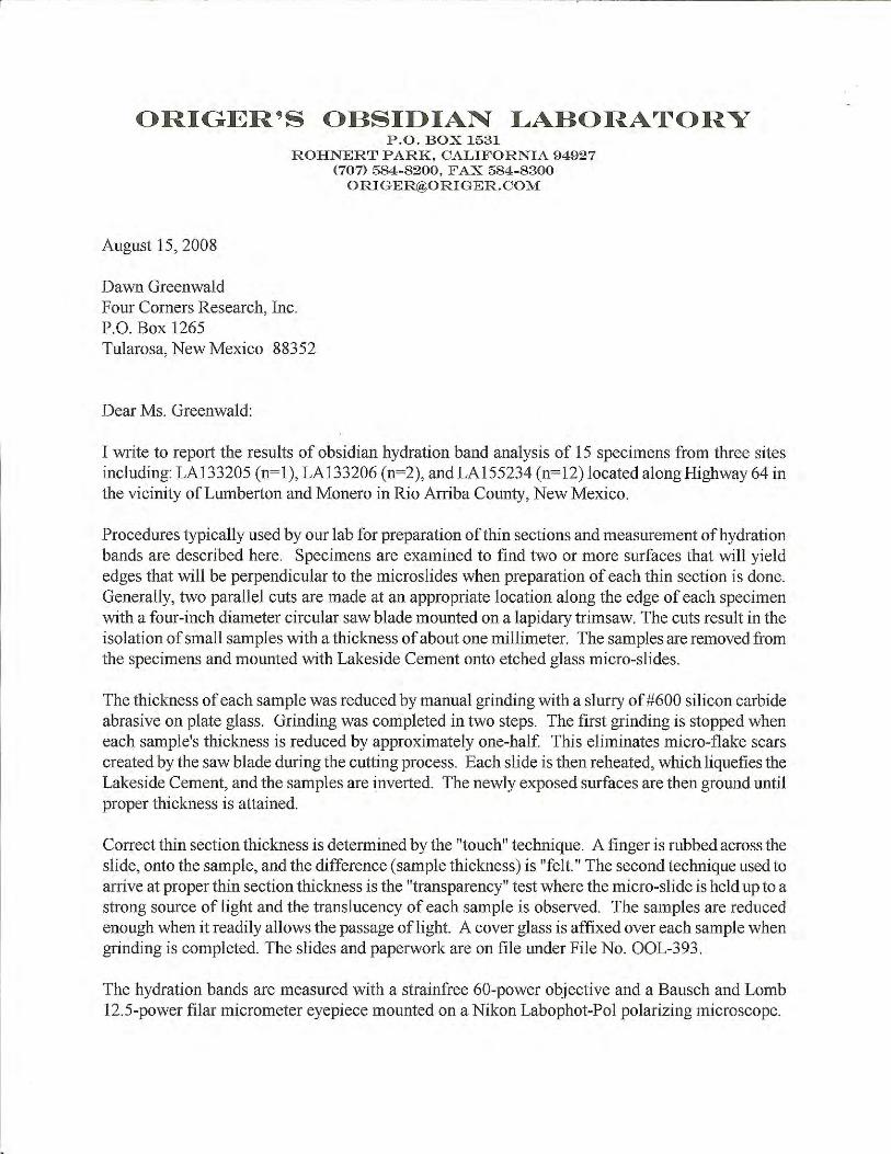

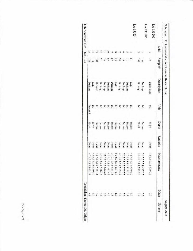
APPENDIX D: ARCHAEOMAGNETIC DATING REPORT FORSITE LA 133206
by
J. Royce CoxArchaeomagnetic Dating Laboratory
Museum of New Mexico
D.2
D.1 Archaeomagnetic Dating
Archaeomagnetic dating derives from the acquisition of a magnetic moment (direction andstrength) by susceptible minerals when they are heated and cooled (Blinman and Cox 2002).When heated to the Curie point (580º & 680º C for magnetite and hematite, respectively),magnetic materials go into a state of flux and lose any prior magnetic orientations. Uponcooling, the magnetic orientations of susceptible minerals are aligned with the earth’sprevailing magnetic field, creating a thermoremanent magnetism (TRM). TRM alignmentsgenerally persist until the material is again heated to the original or a higher temperature.Although most heat events do not reach as high as the Curie temperature, enough of themagnetic material is realigned (partial TRM or pTRM) to provide a detectable orientation.Since the earth’s magnetic field is constantly changing, heated earths retain a record of thepast apparent or virtual geomagnetic pole (VGP) position at the time of cooling. Polepositions from heated archaeological earths can be compared with the regional calibrationof VGP movement through time, and the position of the sample VGP along the calibrationcurve can be interpreted as a date range. Successful archaeomagnetic dating requiresappropriate earthen materials, fires sufficiently hot to create an alignment, recovery ofcarefully aligned set of specimens from the burned archaeological feature, laboratorymeasurement of the specimens to determine a mean pole position or VGP and its error termfor the set, and interpretation of a date range from the juxtaposition of the error ellipse of theset result and a calibration curve.
The archaeomagnetic measurement process starts by letting the individually collectedspecimens “rest” within a zero field after collection. This allows the dissipation of anycontaminating weaker magnetic moments that have been created since the last firing orduring transportation. Each specimen is measured to determine the natural remanentmagnetism (NRM) which is the specimen’s original direction plus any secondary magnetismthat didn’t dissipate. After the initial NRM measurement, the specimens are usuallydemagnetized in an alternating magnetic field (AF) at 50, 100, 150, 200 and 300 Oersted(Oe) steps. If warranted, specimens are taken up by further 100 Oe steps until a significantamount of additional secondary magnetism has been eliminated. Since demagnetizationremoves TRM as well as extraneous orientations, the measurement technician must makea subjective judgment about whether demagnetization has progressed sufficiently and whichdemagnetization level results in the cleanest approximation of the TRM of interest. Duringcollection, specimen orientations are observed as magnetic azimuths using calibratedBrunton compasses. These measurements must be translated into geographic azimuths, usingthe local declination at the time of sample collection. Declinations can be estimated througha series of sun compass readings at the site during collection, but that is not always possible.Declinations for the date and location of sampling can also be estimated by reference to theUSGS Geomag International Geomagnetic Reference Field (IGRF) model(http://geomag.usgs.gov/models/models). The declinations used to calculate the VGPs forthese samples were derived from the USGS IGRF model.
An archaeomagnetic dating result is expressed as a VGP centerpoint and a surrounding errorellipse. The centerpoint is the mean of the orientations of the individual specimens. An error
D.3
ellipse is defined by the dispersion of the individual specimen orientations around the set
95mean. The spread (" ) describes the area within which the mean centerpoint can be expectedto fall 95 percent of the time assuming that the specimen orientations are representative ofthe orientation of the feature as a whole. As error terms become larger, VGP locations areless precisely known and the date range interpretations become larger and less useful. Large
95" values also imply that the TRM contribution to a sample’s magnetic orientation may beweakly expressed compared with other sources of magnetic orientations within the material
95or that the pTRM component was not sufficiently altered within the affected material. "values of less than 1º are excellent and imply a strong TRM that should be relevant for
95dating purposes. " values of more than 4º are imprecise and raise the possibility that themagnetic moment is less exclusively relevant to the TRM of the heating event that is ofarchaeological interest.
In some instances, individual specimen measurements deviate markedly from the rest of thespecimens of the archaeomagnetic set. These outliers can either be defined as specimens thatfall beyond two standard deviations of the sample mean or by physical anomalies, such asa significant change in specimen intensity, difference of material, or separation from the restof the specimens, or other indications by the collector that indicate a specimen might not becongruent with the rest of the archaeomagnetic set (Cox and Blinman 1999; Sternberg andMcGuire 1990). Those outliers that are statistically aberrant are progressively eliminatedfrom the specimen set until remaining specimens fall within two standard deviations of thenew calculated sample mean. Those specimens subjectively indicated as outliers areremoved from the set and the remaining specimens are recalculated.
Three curves are currently in use for date estimation in the greater Southwest (Figure 1). TheWolfman Curve (Cox and Blinman 1999) is used for the A.D. 1000-1450 segment of thecurve, the SWCV2000 curve (Lengyel and Eighmy 2002) is used primarily for the A.D. 650-1000 segment and also A.D. 1450 - present, and occasionally the DuBois Curve (DuBois1989) is used for A.D. 400–650 and also A.D. 1450 - present. Dates interpreted for the A.D.650-1000 period using the SWCV2000 curve are generally accurate, although precision canbe improved (Cox and Blinman 1999). The Archaeomagnetic Dating Lab (ADL) believesthat the Wolfman Curve is both a more accurate and more precise model of VGP movementfor the A.D. 1000-1450 period in the Southwest (Blinman et al. 2007).
The interaction between an error ellipse and the VGP calibration curve determines theestimated date range(s) for a sample result. To the extent that curve paths are accurate andthat VGPs express the TRM exclusively, error ellipses should overlap the curve path.However, neither assumption can be made with absolute confidence. The most commondating convention is to assume that every curve segment that is intersected by or isimmediately adjacent to an error ellipse is potentially relevant to the date interpretation ofthat result. Depending on location and error size, an ellipse can intersect multiple curvesegments, each of which could support a valid date interpretation (although only one iscorrect). To estimate a date range that reflects the precision or imprecision of the VGPestimate, the oval is moved as if the centerpoint were replotted to coincide with the nearestpoint on each curve segment in turn. The points of intersection between the ellipse and each
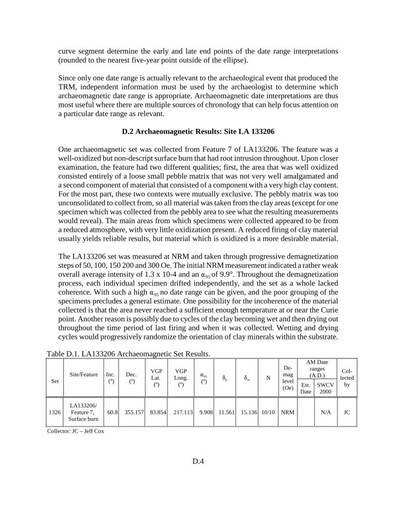
D.4
curve segment determine the early and late end points of the date range interpretations(rounded to the nearest five-year point outside of the ellipse).
Since only one date range is actually relevant to the archaeological event that produced theTRM, independent information must be used by the archaeologist to determine whicharchaeomagnetic date range is appropriate. Archaeomagnetic date interpretations are thusmost useful where there are multiple sources of chronology that can help focus attention ona particular date range as relevant.
D.2 Archaeomagnetic Results: Site LA 133206
One archaeomagnetic set was collected from Feature 7 of LA133206. The feature was awell-oxidized but non-descript surface burn that had root intrusion throughout. Upon closerexamination, the feature had two different qualities; first, the area that was well oxidizedconsisted entirely of a loose small pebble matrix that was not very well amalgamated anda second component of material that consisted of a component with a very high clay content.For the most part, these two contexts were mutually exclusive. The pebbly matrix was toounconsolidated to collect from, so all material was taken from the clay areas (except for onespecimen which was collected from the pebbly area to see what the resulting measurementswould reveal). The main areas from which specimens were collected appeared to be froma reduced atmosphere, with very little oxidization present. A reduced firing of clay materialusually yields reliable results, but material which is oxidized is a more desirable material.
The LA133206 set was measured at NRM and taken through progressive demagnetizationsteps of 50, 100, 150 200 and 300 Oe. The initial NRM measurement indicated a rather weak
95 overall average intensity of 1.3 x 10⁻⁴ and an " of 9.9°. Throughout the demagnetizationprocess, each individual specimen drifted independently, and the set as a whole lacked
95 coherence. With such a high " no date range can be given, and the poor grouping of thespecimens precludes a general estimate. One possibility for the incoherence of the materialcollected is that the area never reached a sufficient enough temperature at or near the Curiepoint. Another reason is possibly due to cycles of the clay becoming wet and then drying outthroughout the time period of last firing and when it was collected. Wetting and dryingcycles would progressively randomize the orientation of clay minerals within the substrate.
Table D.1. LA133206 Archaeomagnetic Set Results.
SetSite/Feature Inc.
(º)Dec.
(º)
VGPLat. (º)
VGPLong.
(º)
95 "(º) p m* * N
De-maglevel(Oe)
AM Dateranges(A.D.)
Col-lected
byEst.Date
SWCV2000
1326LA133206/Feature 7,
Surface burn60.8 355.157 83.854 217.113 9.908 11.561 15.136 10/10 NRM N/A JC
Collector: JC – Jeff Cox

D.5
D.3 Conclusion
Although initial indications of the fired area showed promise, especially with the welloxidized pebbly matrix, the laboratory measurements indicated that the apparently reducedclay areas appeared to have lost their magnetic coherence over the intervening years. Theone specimen collected from the pebbly matrix also proved to be insufficient in magneticproperties, having one of the lowest initial magnetic intensities, as well as having the mosterratic movement during the demagnetization process.
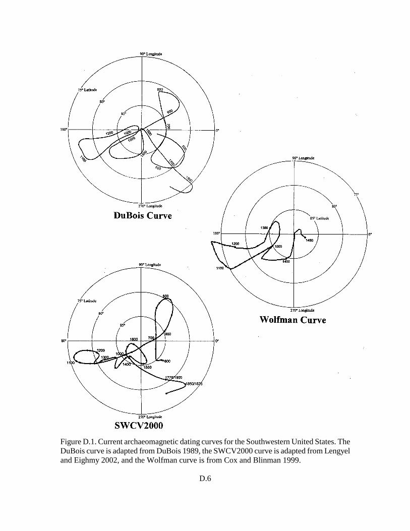
D.6
Figure D.1. Current archaeomagnetic dating curves for the Southwestern United States. TheDuBois curve is adapted from DuBois 1989, the SWCV2000 curve is adapted from Lengyeland Eighmy 2002, and the Wolfman curve is from Cox and Blinman 1999.
D.7
D.4 References Cited
Blinman, Eric, and Jeffrey Royce Cox2002 A Context for the Interpretation of Archaeomagnetic Dating Results from the Pajarito
Plateau. Draft report prepared for the Cultural Resource Management Team, EcologyGroup, Risk Reduction and Environmental Stewardship Division, Los AlamosNational Laboratory. Los Alamos, New Mexico.
Blinman, Eric, J. Royce Cox, and Gary Hein2007 Archaeomagnetic Dating Final Report. Final report prepared for the Cultural
Resource Management Team, Ecology Group, Risk Reduction and EnvironmentalStewardship Division, Los Alamos National Laboratory, New Mexico.
Cox, J. Royce, and Eric Blinman1999 Results of Archaeomagnetic Sample Analysis. Chapter 19, in Pipeline Archaeology
1990-1993: The El Paso Natural Gas North System Expansion Project, New Mexicoand Arizona, Volume XII, Supporting Studies: Nonceramic Artifacts, Subsistenceand Environmental Studies, and Chronometric Studies, compiled by Timothy M.Kearns and Janet L. McVickar. Western Cultural Resource Management, Inc.,Farmington, New Mexico.
DuBois, Robert L.1989 Archaeomagnetic Results from the Southwest United States and Mesoamerica, and
Comparison with Some Other Areas. Physics of the Earth and Planetary Interiors56:18-23.
Lengyel, Stacey N., and Jeffrey L. Eighmy2002 A Revision to the U.S. Southwest Archaeomagnetic Master Curve. Journal of
Archaeological Science 29:1423-1433.
Sternberg, Robert S. and Randall H. McGuire1990 Archaeomagnetic Secular Variation in the American Southwest, A.D. 700-1450.
Chapter 12, in Archaeomagnetic Dating, edited by Jeffrey L. Eighmy and Robert S.Sternberg. The University of Arizona Press, Tucson.

APPENDIX E:
FAUNAL ANALYSIS TABLEAND CODING KEY
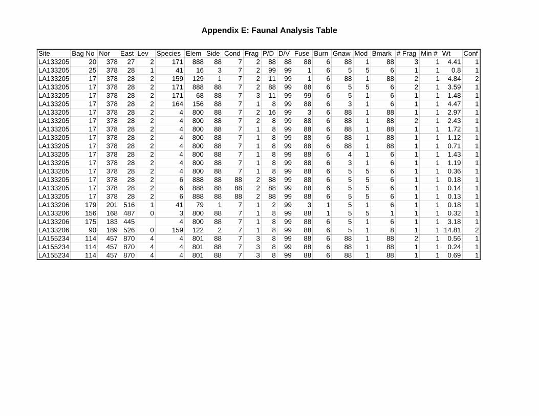
Appendix E: Faunal Analysis Table
Site Bag No Nor East Lev Species Elem Side Cond Frag P/D D/V Fuse Burn Gnaw Mod Bmark # Frag Min # Wt ConfLA133205 20 378 27 2 171 888 88 7 2 88 88 88 6 88 1 88 3 1 4.41 1LA133205 25 378 28 1 41 16 3 7 2 99 99 1 6 5 5 6 1 1 0.8 1LA133205 17 378 28 2 159 129 1 7 2 11 99 1 6 88 1 88 2 1 4.84 2LA133205 17 378 28 2 171 888 88 7 2 88 99 88 6 5 5 6 2 1 3.59 1LA133205 17 378 28 2 171 68 88 7 3 11 99 99 6 5 1 6 1 1 1.48 1LA133205 17 378 28 2 164 156 88 7 1 8 99 88 6 3 1 6 1 1 4.47 1LA133205 17 378 28 2 4 800 88 7 2 16 99 3 6 88 1 88 1 1 2.97 1LA133205 17 378 28 2 4 800 88 7 2 8 99 88 6 88 1 88 2 1 2.43 1LA133205 17 378 28 2 4 800 88 7 1 8 99 88 6 88 1 88 1 1 1.72 1LA133205 17 378 28 2 4 800 88 7 1 8 99 88 6 88 1 88 1 1 1.12 1LA133205 17 378 28 2 4 800 88 7 1 8 99 88 6 88 1 88 1 1 0.71 1LA133205 17 378 28 2 4 800 88 7 1 8 99 88 6 4 1 6 1 1 1.43 1LA133205 17 378 28 2 4 800 88 7 1 8 99 88 6 3 1 6 1 1 1.19 1LA133205 17 378 28 2 4 800 88 7 1 8 99 88 6 5 5 6 1 1 0.36 1LA133205 17 378 28 2 6 888 88 88 2 88 99 88 6 5 5 6 1 1 0.18 1LA133205 17 378 28 2 6 888 88 88 2 88 99 88 6 5 5 6 1 1 0.14 1LA133205 17 378 28 2 6 888 88 88 2 88 99 88 6 5 5 6 1 1 0.13 1LA133206 179 201 516 1 41 79 1 7 1 2 99 3 1 5 1 6 1 1 0.18 1LA133206 156 168 487 0 3 800 88 7 1 8 99 88 1 5 5 1 1 1 0.32 1LA133206 175 183 445 4 800 88 7 1 8 99 88 6 5 1 6 1 1 3.18 1LA133206 90 189 526 0 159 122 2 7 1 8 99 88 6 5 1 8 1 1 14.81 2LA155234 114 457 870 4 4 801 88 7 3 8 99 88 6 88 1 88 2 1 0.56 1LA155234 114 457 870 4 4 801 88 7 3 8 99 88 6 88 1 88 1 1 0.24 1LA155234 114 457 870 4 4 801 88 7 3 8 99 88 6 88 1 88 1 1 0.69 1
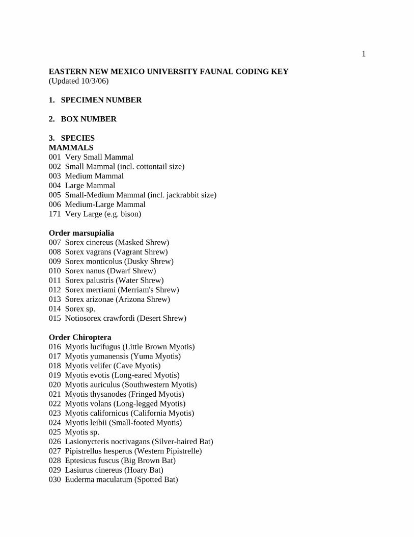
1
EASTERN NEW MEXICO UNIVERSITY FAUNAL CODING KEY (Updated 10/3/06) 1. SPECIMEN NUMBER 2. BOX NUMBER 3. SPECIES MAMMALS 001 Very Small Mammal 002 Small Mammal (incl. cottontail size) 003 Medium Mammal 004 Large Mammal 005 Small-Medium Mammal (incl. jackrabbit size) 006 Medium-Large Mammal 171 Very Large (e.g. bison) Order marsupialia 007 Sorex cinereus (Masked Shrew) 008 Sorex vagrans (Vagrant Shrew) 009 Sorex monticolus (Dusky Shrew) 010 Sorex nanus (Dwarf Shrew) 011 Sorex palustris (Water Shrew) 012 Sorex merriami (Merriam's Shrew) 013 Sorex arizonae (Arizona Shrew) 014 Sorex sp. 015 Notiosorex crawfordi (Desert Shrew) Order Chiroptera 016 Myotis lucifugus (Little Brown Myotis) 017 Myotis yumanensis (Yuma Myotis) 018 Myotis velifer (Cave Myotis) 019 Myotis evotis (Long-eared Myotis) 020 Myotis auriculus (Southwestern Myotis) 021 Myotis thysanodes (Fringed Myotis) 022 Myotis volans (Long-legged Myotis) 023 Myotis californicus (California Myotis) 024 Myotis leibii (Small-footed Myotis) 025 Myotis sp. 026 Lasionycteris noctivagans (Silver-haired Bat) 027 Pipistrellus hesperus (Western Pipistrelle) 028 Eptesicus fuscus (Big Brown Bat) 029 Lasiurus cinereus (Hoary Bat) 030 Euderma maculatum (Spotted Bat)
2
031 Plecotus townsendii (Townsend's Big-eared Bat) 032 Idionycteris phyllotis (Allen's Big-eared Bat) 033 Antrozous pallidus (Pallid Bat) 034 Tadarida brasiliensis (Brazilian Free-tailed Bat) 035 Tadarida macrotis (Big Free-tailed Bat) 036 Tadarida sp. Order Lagomorpha 037 Ochotona princeps (Pika) 038 Sylvilagus floridanus (Eastern Cottontail) 039 Sylvilagus nuttallii (Nuttall's Cottontail) 040 Sylvilagus audubonii (Desert Cottontail) 041 Sylvilagus sp. 042 Lepus americanus (Snowshoe Hare) 043 Lepus townsendii (White-tailed Jack Rabbit) 044 Lepus californicus (Black-tailed Jack Rabbit) 045 Lepus callotis (White-sided Jack Rabbit) 046 Lepus alleni (Antelope Jack Rabbit) 047 Lepus sp. 173 Lagomorph Order Rodentia 048 Eutamian minimus (Least Chipmunk) 049 Eutamian dorsalis (Cliff Chipmunk) 050 Eutamias quadrivittatus (Colorado Chipmunk) 051 Eutamias cinereicollis (Gray-collared Chipmunk) 052 Eutamias sp. 053 Mormota flaviventris (Yellow-bellied Marmot) 054 Ammospermophilus harrisii (Harris' Antelope Squirrel) 055 Ammospermophilus leucurus (White-tailed Antelope Squirrel) 056 Citellus tridecemlineatus (Thirteen-lined Ground Squirrel) 057 Citellus mexicanus (Mexican Ground Squirrel) 058 Citellus spilosoma (Spotted Ground Squirrel) 059 Citellus variegatus (Rock Squirrel) 060 Citellus lateralis (Golden-mantled Ground Squirrel) 061 Citellus sp. (Ground Squirrels) 062 Ammospermophilus/Spermophilus 063 Cynomys gunnisoni (Gunnison's Prairie Dog) 064 Cynomys ludovicianus (Black-tailed Prairie Dog) 170 Cynomys sp. 065 Sciurus aberti (Abert's Squirrel) 066 Sciurus sp. 067 Tamiasciurus hudsonicus (Red Squirrel) 068 Thomomys bottae (Botta's Pocket Gopher)
3
069 Thomomys talpoides (Northern Pocket Gopher) 070 Thomomys sp. 071 Geomys bursarius (Plains Pocket Gopher) 072 Geomys arenarius (Desert Pocket Gopher) 073 Geomys sp. 074 Pappogeomys castanops (Yellow-faced Pocket Gopher) 075 Perognathus flavescens (Plains Pocket Mouse) 076 Perognathus flavus (Silky Pocket Mouse) 077 Perognathus baileyi (Bailey's Pocket Mouse) 078 Perognathus hispidus (Hispid Pocket Mouse) 079 Perognathus penicillatus (Desert Pocket Mouse) 080 Perognathus intermedius (Rock Pocket Mouse) 081 Perognathus sp. 082 Dipodomys ordii (Ord's Kangaroo Rat) 083 Dipodomys spectabilis (Banner-tailed Kangaroo Rat) 084 Dipodomys merriami (Merriam's Kangaroo Rat) 085 Dipodomys sp. (Kangaroo Rats) 086 Castor canadensis (Beaver) 087 Reithrodontomys montanus (Plains Harvest Mouse) 088 Reithrodontomys megalotis (Western Harvest Mouse) 089 Reithrodontomys sp. (Harvest Mouse) 090 Peromyscus eremicus (Cactus Mouse) 091 Peromyscus maniculatus (Deer Mouse) 092 Peromyscus leucopus (White-footed Mouse) 093 Peromyscus crinitus (Canyon Mouse) 094 Peromyscus boylii (Brush Mouse) 095 Peromyscus truei (Pinon Mouse) 096 Peromyscus difficilis (Rock Mouse) 097 Peromyscus sp. (Mice) 098 Onychomys leucogaster (Northern Grasshopper Mouse) 099 Onychomys torridus (Southern Grasshopper Mouse) 100 Onychomys sp. (Grasshopper Mouse) 101 Sigmodon hispidus (Hispid Cotton Rat) 102 Sigmodon fulviventer (Tawny-bellied Cotton Rat) 103 Sigmodon sp. (Cotton Rat) 104 Neotoma micropus (Southern Plains Woodrat) 105 Neotoma albigula (White-throated Woodrat) 106 Neotoma mexicana (Mexican Woodrat) 107 Neotoma cinerea (Bushy-tailed Woodrat) 108 Neotoma stephensi (Stephen's Woodrat) 109 Neotoma sp. (Woodrats) 110 Clethrionomys gapperi (Southern Red-backed Vole) 111 Phenacomys intermedius (Heather Vole) 112 Microtus pennsylvanicus (Meadow Vole)
4
113 Microtus montanus (Montane Vole) 114 Microtus longicaudus (Long-tailed Vole) 115 Microtus mexicanus (Mexican Vole) 116 Microtus sp. (Voles) 117 Ondatra zibethicus (Muskrat) 118 Zapus princeps (Western Jumping Mouse) 119 Erethizon dorsatum (Porcupine) Order Carnivora 120 Canis latrans (Coyote) 121 Canis lupus (Wolf) 122 Canis familarus (Domestic Dog) 123 Canis sp. 124 Vulpes fulva (Red Fox) 125 Vulpes macrotis (Desert Fox) 126 Vulpes velox (Swift Fox) 127 Vulpes sp. 128 Urocyon cinereoargenteus (Gray Fox) 129 Ursus americanus (Black Bear) 130 Ursus horribilis (Grizzly Bear) 131 Ursus sp. 132 Bassariscus astutus (Ringtail) 133 Pyrocyon lotor (Racoon) 134 Nasua nasua (Coati) 135 Mustela erminea (Ermine, or Short-tailed Weasel) 136 Mustela frenata (Long-tailed Weasel) 137 Mustela nigripes (Black-footed Ferret) 138 Taxidea taxus (Badger) 139 Spilogale gracilis (Western Spotted Skunk) 140 Mephitis mephitis (Striped Skunk) 141 Mephitis macroura (Hooded Skunk) 142 Conepatus mesoluecus (Hog-nosed Skunk) 143 Felis onca (Jaguar) 144 Felis concolor (Mountain Lion) 145 Felis rufus (Bobcat) 146 Small Carnivore 147 Medium Carnivore 148 Large Carnivore
5
Order Artiodactyla 149 Sus (Pig) 150 Dicotyles tajuca (Javelina) 151 Cervus elaphus (Elk) 152 Odocoileus hemionus (Mule Deer) 153 Odocoileus virginianus (White-tailed Deer) 154 Odocoileus sp. 155 Antilocapra americana (Pronghorn) 156 Odocoileus/Antilocapra 157 Bison bison (Bison) 158 Bos taurus (Domestic Cow) 159 Bos/Bison 160 Ovis canadensis (Bighorn Sheep) 161 Odocoileus/Ovis 162 Ovis-Capra (Domestic Sheep-Goat) 163 Small Artiodactyl 164 Medium Artiodactyl (deer/pronghorn size) 165 Large Artiodactyl 166 Antilope cervicapra (Blackbuck antelope, Old World) 167 Equus caballus (Horse) 170 Cynomys sp. 171 Very Large 172 Lutra canadensis (River Otter) 173 Lagomorph 190 Mammuthus sp. 191 Dasypus novemcinctus (Armadillo) BIRDS 200 Small Bird 201 Medium Bird 202 Large Bird Order Podicipediiformes 203 Podilymbus podiceps (Pied-billed Grebe) 204 Podiceps auritus (Horned Grebe) 205 Podiceps nigricollis (Eared Grebe) 206 Podiceps grisegena (Red-necked Grebe) 207 Tachybaptus dominicus (Least Grebe) 208 Aechmophorus occidentalis (Western Grebe) 209 Aechmophorus clarkii (Clark's Grebe)
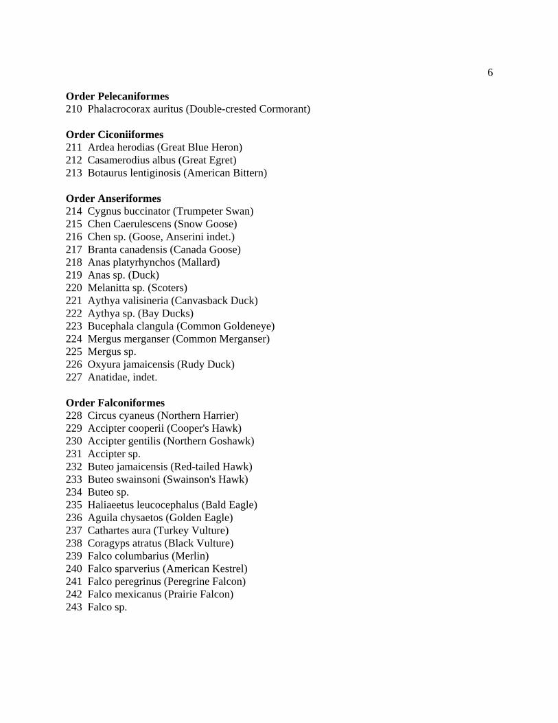
6
Order Pelecaniformes 210 Phalacrocorax auritus (Double-crested Cormorant) Order Ciconiiformes 211 Ardea herodias (Great Blue Heron) 212 Casamerodius albus (Great Egret) 213 Botaurus lentiginosis (American Bittern) Order Anseriformes 214 Cygnus buccinator (Trumpeter Swan) 215 Chen Caerulescens (Snow Goose) 216 Chen sp. (Goose, Anserini indet.) 217 Branta canadensis (Canada Goose) 218 Anas platyrhynchos (Mallard) 219 Anas sp. (Duck) 220 Melanitta sp. (Scoters) 221 Aythya valisineria (Canvasback Duck) 222 Aythya sp. (Bay Ducks) 223 Bucephala clangula (Common Goldeneye) 224 Mergus merganser (Common Merganser) 225 Mergus sp. 226 Oxyura jamaicensis (Rudy Duck) 227 Anatidae, indet. Order Falconiformes 228 Circus cyaneus (Northern Harrier) 229 Accipter cooperii (Cooper's Hawk) 230 Accipter gentilis (Northern Goshawk) 231 Accipter sp. 232 Buteo jamaicensis (Red-tailed Hawk) 233 Buteo swainsoni (Swainson's Hawk) 234 Buteo sp. 235 Haliaeetus leucocephalus (Bald Eagle) 236 Aguila chysaetos (Golden Eagle) 237 Cathartes aura (Turkey Vulture) 238 Coragyps atratus (Black Vulture) 239 Falco columbarius (Merlin) 240 Falco sparverius (American Kestrel) 241 Falco peregrinus (Peregrine Falcon) 242 Falco mexicanus (Prairie Falcon) 243 Falco sp.
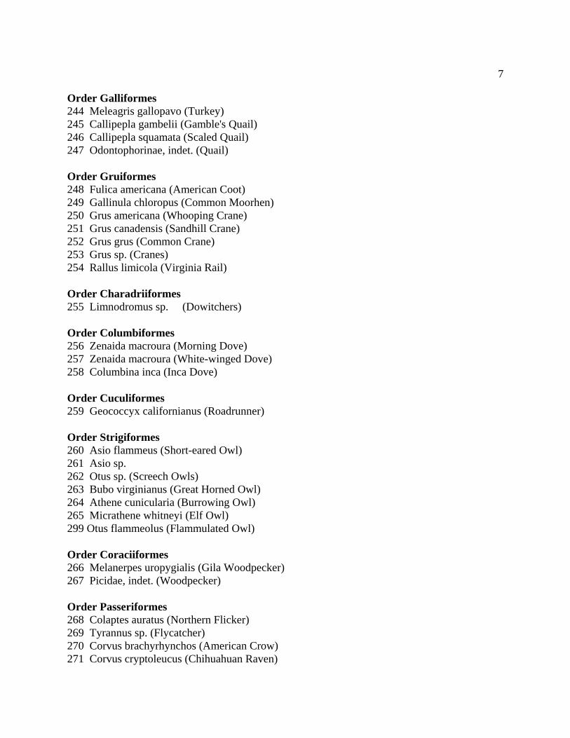
7
Order Galliformes 244 Meleagris gallopavo (Turkey) 245 Callipepla gambelii (Gamble's Quail) 246 Callipepla squamata (Scaled Quail) 247 Odontophorinae, indet. (Quail) Order Gruiformes 248 Fulica americana (American Coot) 249 Gallinula chloropus (Common Moorhen) 250 Grus americana (Whooping Crane) 251 Grus canadensis (Sandhill Crane) 252 Grus grus (Common Crane) 253 Grus sp. (Cranes) 254 Rallus limicola (Virginia Rail) Order Charadriiformes 255 Limnodromus sp. (Dowitchers) Order Columbiformes 256 Zenaida macroura (Morning Dove) 257 Zenaida macroura (White-winged Dove) 258 Columbina inca (Inca Dove) Order Cuculiformes 259 Geococcyx californianus (Roadrunner) Order Strigiformes 260 Asio flammeus (Short-eared Owl) 261 Asio sp. 262 Otus sp. (Screech Owls) 263 Bubo virginianus (Great Horned Owl) 264 Athene cunicularia (Burrowing Owl) 265 Micrathene whitneyi (Elf Owl) 299 Otus flammeolus (Flammulated Owl) Order Coraciiformes 266 Melanerpes uropygialis (Gila Woodpecker) 267 Picidae, indet. (Woodpecker) Order Passeriformes 268 Colaptes auratus (Northern Flicker) 269 Tyrannus sp. (Flycatcher) 270 Corvus brachyrhynchos (American Crow) 271 Corvus cryptoleucus (Chihuahuan Raven)
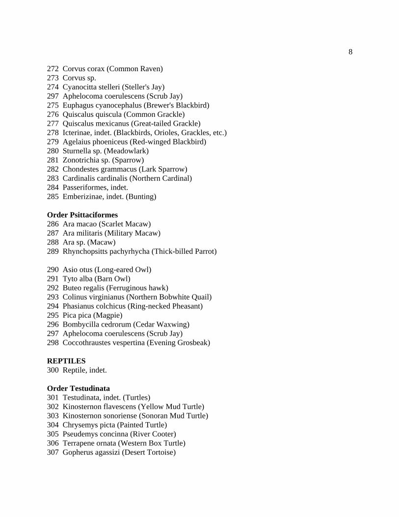
8
272 Corvus corax (Common Raven) 273 Corvus sp. 274 Cyanocitta stelleri (Steller's Jay) 297 Aphelocoma coerulescens (Scrub Jay) 275 Euphagus cyanocephalus (Brewer's Blackbird) 276 Quiscalus quiscula (Common Grackle) 277 Quiscalus mexicanus (Great-tailed Grackle) 278 Icterinae, indet. (Blackbirds, Orioles, Grackles, etc.) 279 Agelaius phoeniceus (Red-winged Blackbird) 280 Sturnella sp. (Meadowlark) 281 Zonotrichia sp. (Sparrow) 282 Chondestes grammacus (Lark Sparrow) 283 Cardinalis cardinalis (Northern Cardinal) 284 Passeriformes, indet. 285 Emberizinae, indet. (Bunting) Order Psittaciformes 286 Ara macao (Scarlet Macaw) 287 Ara militaris (Military Macaw) 288 Ara sp. (Macaw) 289 Rhynchopsitts pachyrhycha (Thick-billed Parrot) 290 Asio otus (Long-eared Owl) 291 Tyto alba (Barn Owl) 292 Buteo regalis (Ferruginous hawk) 293 Colinus virginianus (Northern Bobwhite Quail) 294 Phasianus colchicus (Ring-necked Pheasant) 295 Pica pica (Magpie) 296 Bombycilla cedrorum (Cedar Waxwing) 297 Aphelocoma coerulescens (Scrub Jay) 298 Coccothraustes vespertina (Evening Grosbeak) REPTILES 300 Reptile, indet. Order Testudinata 301 Testudinata, indet. (Turtles) 302 Kinosternon flavescens (Yellow Mud Turtle) 303 Kinosternon sonoriense (Sonoran Mud Turtle) 304 Chrysemys picta (Painted Turtle) 305 Pseudemys concinna (River Cooter) 306 Terrapene ornata (Western Box Turtle) 307 Gopherus agassizi (Desert Tortoise)
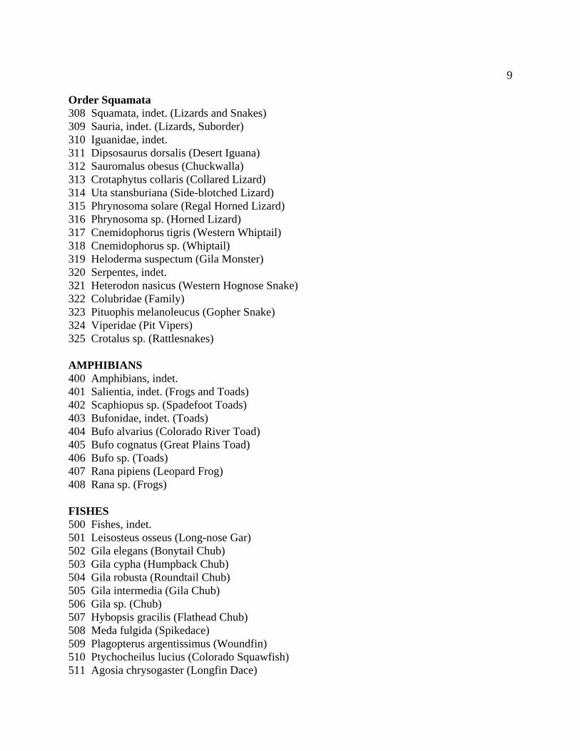
9
Order Squamata 308 Squamata, indet. (Lizards and Snakes) 309 Sauria, indet. (Lizards, Suborder) 310 Iguanidae, indet. 311 Dipsosaurus dorsalis (Desert Iguana) 312 Sauromalus obesus (Chuckwalla) 313 Crotaphytus collaris (Collared Lizard) 314 Uta stansburiana (Side-blotched Lizard) 315 Phrynosoma solare (Regal Horned Lizard) 316 Phrynosoma sp. (Horned Lizard) 317 Cnemidophorus tigris (Western Whiptail) 318 Cnemidophorus sp. (Whiptail) 319 Heloderma suspectum (Gila Monster) 320 Serpentes, indet. 321 Heterodon nasicus (Western Hognose Snake) 322 Colubridae (Family) 323 Pituophis melanoleucus (Gopher Snake) 324 Viperidae (Pit Vipers) 325 Crotalus sp. (Rattlesnakes) AMPHIBIANS 400 Amphibians, indet. 401 Salientia, indet. (Frogs and Toads) 402 Scaphiopus sp. (Spadefoot Toads) 403 Bufonidae, indet. (Toads) 404 Bufo alvarius (Colorado River Toad) 405 Bufo cognatus (Great Plains Toad) 406 Bufo sp. (Toads) 407 Rana pipiens (Leopard Frog) 408 Rana sp. (Frogs) FISHES 500 Fishes, indet. 501 Leisosteus osseus (Long-nose Gar) 502 Gila elegans (Bonytail Chub) 503 Gila cypha (Humpback Chub) 504 Gila robusta (Roundtail Chub) 505 Gila intermedia (Gila Chub) 506 Gila sp. (Chub) 507 Hybopsis gracilis (Flathead Chub) 508 Meda fulgida (Spikedace) 509 Plagopterus argentissimus (Woundfin) 510 Ptychocheilus lucius (Colorado Squawfish) 511 Agosia chrysogaster (Longfin Dace)

10
512 Rhinichthys osculus (Speckled Dace) 513 Xyrauchen texanus (Razorback Sucker) 514 Catostomus insignis (Gila Coarse-scaled Sucker) 515 Catostomus latipinnis (Flannelmouth Sucker) 516 Catostomus sp. (Sucker) 517 Catostomus [=Pantosteus] clarki (Gila Mountain Sucker) 518 Cyprinidae 519 Cyprinidae/Catostomidae 888 Unknown 4. ELEMENT 001 Basioccipital 002 Occipital 003 Sphenoid 004 Pterygoid 005 Vomer 006 Palatine 007 Interparietal 008 Parietal 009 Frontal 010 Temporal 011 Occipital Condyle 012 Frontal/Parietal 013 Temporal/Occipital 014 Temporal/Parietal 015 Temporal/Frontal 016 Temporal/Frontal/Parietal 017 Occipital/Temporal/Parietal 018 Bulla 019 Bulla/Petrous 020 Squamous 021 Supraorbital 022 Petrous 023 Zygomatic Arch 024 Malar 025 Lacrimal 026 Nasal 027 Premaxilla w/ teeth 028 Premaxilla w/o teeth 029 Maxilla w/ teeth 030 Maxilla w/o teeth 031 Maxilla-Premaxilla w/ teeth 032 Maxilla-Premaxilla w/o teeth 033 Frontal/Premaxilla w/ teeth
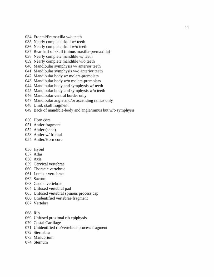
11
034 Frontal/Premaxilla w/o teeth 035 Nearly complete skull w/ teeth 036 Nearly complete skull w/o teeth 037 Rear half of skull (minus maxilla-premaxilla) 038 Nearly complete mandible w/ teeth 039 Nearly complete mandible w/o teeth 040 Mandibular symphysis w/ anterior teeth 041 Mandibular symphysis w/o anterior teeth 042 Mandibular body w/ molars-premolars 043 Mandibular body w/o molars-premolars 044 Mandibular body and symphysis w/ teeth 045 Mandibular body and symphysis w/o teeth 046 Mandibular ventral border only 047 Mandibular angle and/or ascending ramus only 048 Unid. skull fragment 049 Back of mandible-body and angle/ramus but w/o symphysis 050 Horn core 051 Antler fragment 052 Antler (shed) 053 Antler w/ frontal 054 Antler/Horn core 056 Hyoid 057 Atlas 058 Axis 059 Cervical vertebrae 060 Thoracic vertebrae 061 Lumbar vertebrae 062 Sacrum 063 Caudal vertebrae 064 Unfused vertebral pad 065 Unfused vertebral spinous process cap 066 Unidentified vertebrae fragment 067 Vertebra 068 Rib 069 Unfused proximal rib epiphysis 070 Costal Cartilage 071 Unidentified rib/vertebrae process fragment 072 Sternebra 073 Manubrium 074 Sternum
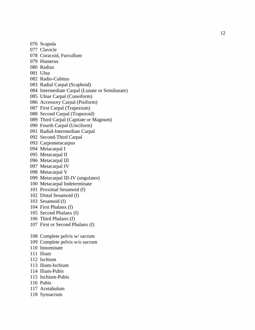
12
076 Scapula 077 Clavicle 078 Coracoid, Furcullum 079 Humerus 080 Radius 081 Ulna 082 Radio-Cubitus 083 Radial Carpal (Scaphoid) 084 Intermediate Carpal (Lunate or Semilunate) 085 Ulnar Carpal (Cuneiform) 086 Accessory Carpal (Pisiform) 087 First Carpal (Trapezium) 088 Second Carpal (Trapezoid) 089 Third Carpal (Capitate or Magnum) 090 Fourth Carpal (Unciform) 091 Radial-Intermediate Carpal 092 Second-Third Carpal 093 Carpometacarpus 094 Metacarpal I 095 Metacarpal II 096 Metacarpal III 097 Metacarpal IV 098 Metacarpal V 099 Metacarpal III-IV (ungulates) 100 Metacarpal Indeterminate 101 Proximal Sesamoid (f) 102 Distal Sesamoid (f) 103 Sesamoid (f) 104 First Phalanx (f) 105 Second Phalanx (f) 106 Third Phalanx (f) 107 First or Second Phalanx (f) 108 Complete pelvis w/ sacrum 109 Complete pelvis w/o sacrum 110 Innominate 111 Ilium 112 Ischium 113 Ilium-Ischium 114 Ilium-Pubis 115 Ischium-Pubis 116 Pubis 117 Acetabulum 118 Synsacrum
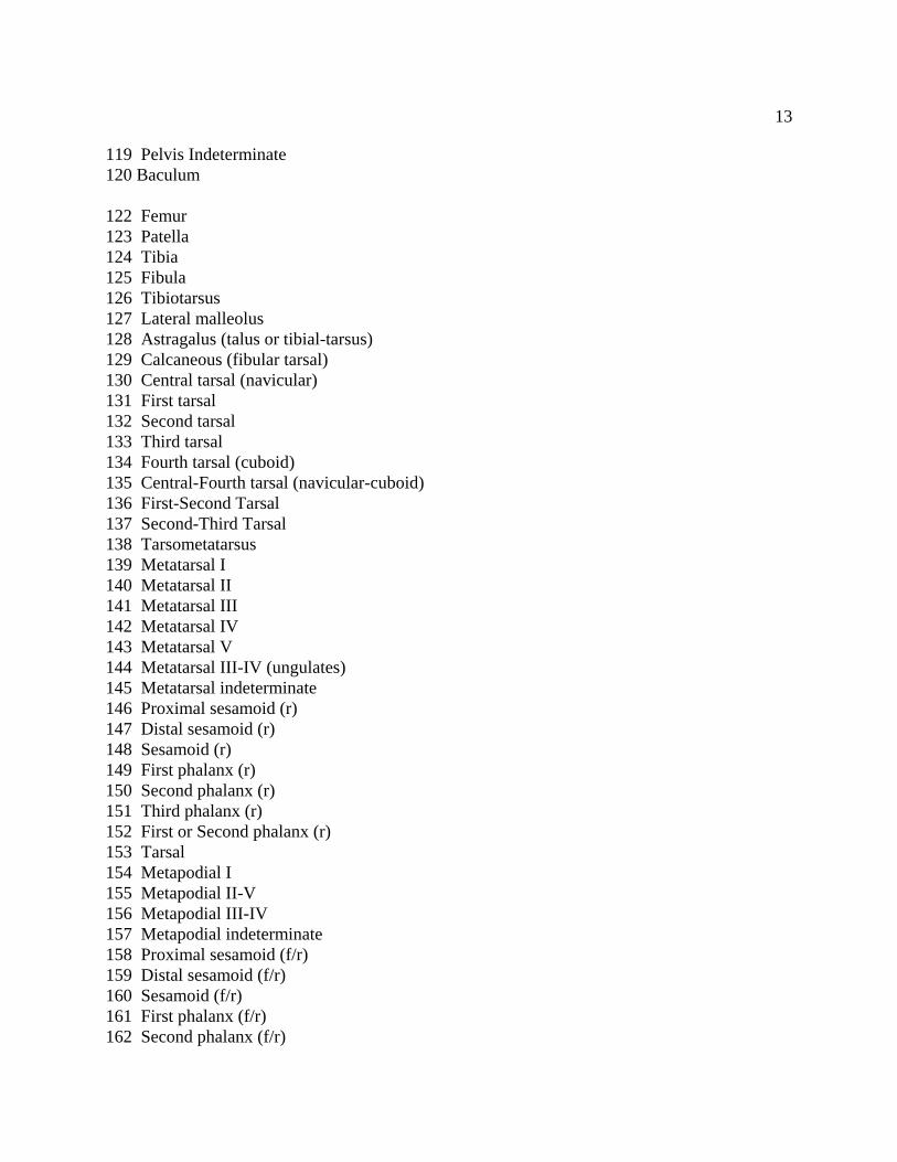
13
119 Pelvis Indeterminate 120 Baculum 122 Femur 123 Patella 124 Tibia 125 Fibula 126 Tibiotarsus 127 Lateral malleolus 128 Astragalus (talus or tibial-tarsus) 129 Calcaneous (fibular tarsal) 130 Central tarsal (navicular) 131 First tarsal 132 Second tarsal 133 Third tarsal 134 Fourth tarsal (cuboid) 135 Central-Fourth tarsal (navicular-cuboid) 136 First-Second Tarsal 137 Second-Third Tarsal 138 Tarsometatarsus 139 Metatarsal I 140 Metatarsal II 141 Metatarsal III 142 Metatarsal IV 143 Metatarsal V 144 Metatarsal III-IV (ungulates) 145 Metatarsal indeterminate 146 Proximal sesamoid (r) 147 Distal sesamoid (r) 148 Sesamoid (r) 149 First phalanx (r) 150 Second phalanx (r) 151 Third phalanx (r) 152 First or Second phalanx (r) 153 Tarsal 154 Metapodial I 155 Metapodial II-V 156 Metapodial III-IV 157 Metapodial indeterminate 158 Proximal sesamoid (f/r) 159 Distal sesamoid (f/r) 160 Sesamoid (f/r) 161 First phalanx (f/r) 162 Second phalanx (f/r)
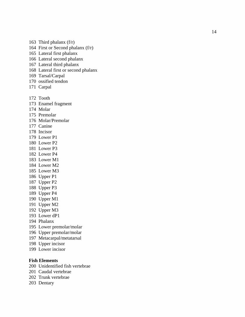
14
163 Third phalanx (f/r) 164 First or Second phalanx (f/r) 165 Lateral first phalanx 166 Lateral second phalanx 167 Lateral third phalanx 168 Lateral first or second phalanx 169 Tarsal/Carpal 170 ossified tendon 171 Carpal 172 Tooth 173 Enamel fragment 174 Molar 175 Premolar 176 Molar/Premolar 177 Canine 178 Incisor 179 Lower P1 180 Lower P2 181 Lower P3 182 Lower P4 183 Lower M1 184 Lower M2 185 Lower M3 186 Upper P1 187 Upper P2 188 Upper P3 189 Upper P4 190 Upper M1 191 Upper M2 192 Upper M3 193 Lower dP1 194 Phalanx 195 Lower premolar/molar 196 Upper premolar/molar 197 Metacarpal/metatarsal 198 Upper incisor 199 Lower incisor Fish Elements 200 Unidentified fish vertebrae 201 Caudal vertebrae 202 Trunk vertebrae 203 Dentary
15
204 Secondary Pectoral Girdle 205 Scale 206 Palatine 207 Opercle 208 Quadrate 209 Urohyal 210 Articular 211 Post-temporal 212 Supratemporal 213 Maxillary 214 Parasphenoid 215 Spines (Rays) 216 Pharyngeal 217 Cleithrum Amphibian Elements 300 Tibio-fibula 301 Episternum/Omisternum 302 Urostyle 303 Radio-ulna 304 Coracoid 305 Vertebrae 306 Parasphenoid (Frog) 307 Exoccipital (Frog) 308 Ethmoid (Frog) 309 Pterygoid (Frog) 310 Fronto-parietal (Frog) Reptile Elements 400 Snake vertebrae 401 Snake mandible 402 Turtle carapace 403 Turtle plastron 404 Lizard skull fragment 405 Lizard occipital complex 406 Lizard dentary 407 Lizard vertebrae Bird Elements 500 Ungual phalange (terminal phalanx) 501 Coccygeal vertebrae 502 Pygostyle 503 Quadrate 504 Scapholunar
16
505 "Beak" 506 Pollex 507 Phalange 508 Windpipe 509 Furcula 510 Coracoid 511 Tibiotarsus 512 Tarsometatarsus 513 Carpometacarpus 514 Scleral 515 Fused thoracic vertebrae (#2-5) 516 Fused lumbar vertebrae 517 Ossified tendon 518 Basihyal 520 Eggshell Miscellaneous 800 Unidentifiable shaft fragment 801 Unidentifiable cancellous fragment 802 Bone percussion flake 803 Bone "splinters" 888 Indeterminate fragments 999 Not applicable 5. SIDE or SYMMETRY 01 Left 02 Right 03 Medial 88 Indeterminate 99 Not applicable
17
6. CONDITION 01 Complete 02 Complete except for unfused epiphysis(es) 03 Nearly complete (slightly broken or damaged) 04 More than 3/4 complete 05 1/2 to 3/4 complete 06 1/4 to 1/2 complete 07 Less then 1/4 complete 88 Indeterminate 99 Not applicable 7. ORIGIN OF FRAGMENTATION 01 Largely pre- or slightly post-depositional 02 Partly pre-depositional and partly recent damage 03 Largely recent damage 04 Probably pre-depositional 05 Probably recent damage 88 Indeterminate 99 Not applicable 8. PROXIMAL-DISTAL (exclude teeth, vertebrae, skull, mandible, and sternum) 01 Complete 02 Proximal epiphysis only 03 Proximal end 04 Proximal shaft minus proximal epiphysis (unfused) 05 Proximal shaft fragment 06 Proximal end and shaft (broken) 07 Proximal end and shaft (unfused distal epiphysis missing) 08 Shaft (both ends broken) 09 Shaft (both unfused epiphyses missing) 10 Distal epiphysis only 11 Distal end 12 Distal shaft minus distal epiphysis (unfused) 13 Distal shaft fragment 14 Distal end and shaft (broken) 15 Distal end and shaft (unfused proximal epiphysis missing) 16 Distal or Proximal unfused epiphysis (18-36 innominates only) 18 Complete Innominate 19 Ilium, Ischium, Pubis present in portions- no Acetabulum 20 Ilium, Ischium, Pubis, Acetabulum all present in portions 21 Pubis unfused 22 Ilium unfused
18
23 Ischium unfused 24 Ischium with Acetabulum 25 Ischium without Acetabulum 26 Ilium with Acetabulum 27 Ilium without Acetabulum 28 Pubis with Acetabulum 29 Pubis without Acetabulum 30 Acetabulum area only 31 Ishium and Pubis present in portions with Acetabulum 32 Ischium and Pubis present in portions without Acetabulum 33 Ilium and Pubis present in portions with Acetabulum 34 Ilium and Pubis present in portions without Acetabulum 35 Ilium and Ischium present in portions with Acetabulum 36 Ilium and Ischium present in portions without Acetabulum 88 Indeterminate 99 Not Applicable 9. DORSAL-VENTRAL (only for vertebrae) 01 Complete (both ventral and dorsal parts present) 02 Vertebral body only 03 Vertebral arch with nearly complete processes 04 Spinous process 05 Spinous process (dorsal) 06 Transverse process 07 Spinous process (unfused cap or summit) 08 Spinous process (ventral) 09 Vertebral body and part of arch 10 Vertebral arch fragment only 11 Vertebral pad 12 Vertebral articular surface 13 Transverse process with part of vertebral body 88 Indeterminate vertebral fragment 99 Not applicable 10. FUSION 01 Fused 02 Fusing 03 Unfused 04 Proximal/Anterior fused; Distal/Posterior fusing 05 Proximal/Anterior fused; Distal/Posterior unfused 06 Proximal/Anterior fusing; Distal/Posterior fused 07 Proximal/Anterior fusing; Distal/Posterior unfused 08 Proximal/Anterior unfused; Distal/Posterior fused 09 Proximal/Anterior unfused; Distal/Posterior fusing
19
10 Fetal 11 Immature 88 Indeterminate 99 Not applicable 11. BURNING 01 Calcined (white or gray) 02 Charred (black) 03 Calcined and charred 04 Cooking browned 05 Possibly burned 06 Unburned 88 Indeterminate 99 Not Applicable 12. BONE ARTIFACTS 01 Awl/Hairpin 02 Ring 03 Bead 04 Needle (long/ultrathin "awl" with threading hole) 05 Wand 06 Antler flaker 07 Tube 08 Whistle 09 Drill 10 Rasp 11 Incised 12 Tool/implement 13 Worked - function unknown 14 Possibly worked 88 Indeterminate 99 Not modified 13. GNAWING 01 Rodent gnawed 02 Carnivore gnawed 03 Gnawed 04 Possibly gnawed 05 Ungnawed 07 Not collected 88 Indeterminate 14. NATURAL MODIFICATION 01 Weathered 02 Root etched
20
03 Diseased 04 CaCO3 coated 05 Not modified 06 Possibly etched by stomach acids 07 Not collected 88 Indeterminate 99 Not applicable 15. BUTCHERING MARKS 01 "V" shaped grooves 02 "U" shaped grooves 03 Parallel striations 04 Present 05 Possibly present 06 Absent 07 Not collected 88 Indeterminate 99 Not applicable 16. ACTUAL NUMBER OF FRAGMENTS Enter actual bone count (including old and recent breaks) 17. MINIMUM NUMBER OF FRAGMENTS Enter minimum bone count (after refitting or estimating minimum count after potential refitting) 18. WEIGHT 19. LEVEL OF CONFIDENCE IN SPECIES DETERMINATION 01 Sure 02 cf. 03 Unsure/Indeterminate 99 Not Applicable 20. COMMENTS
APPENDIX F:
ENERGY DISPERSIVE X-RAY FLOURESCENCE (EDXRF) ANALYSIS
by
Geochemical Research LaboratoryMenlo Park, California

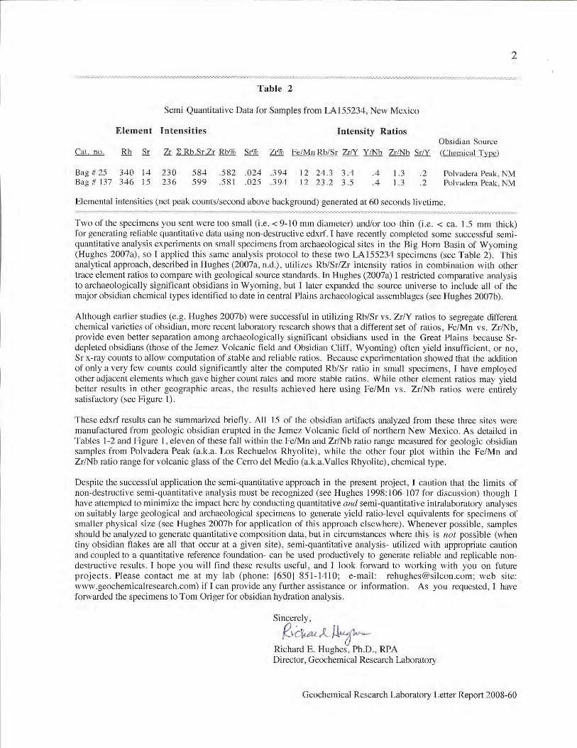
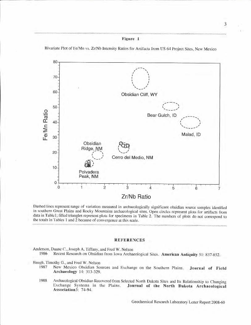
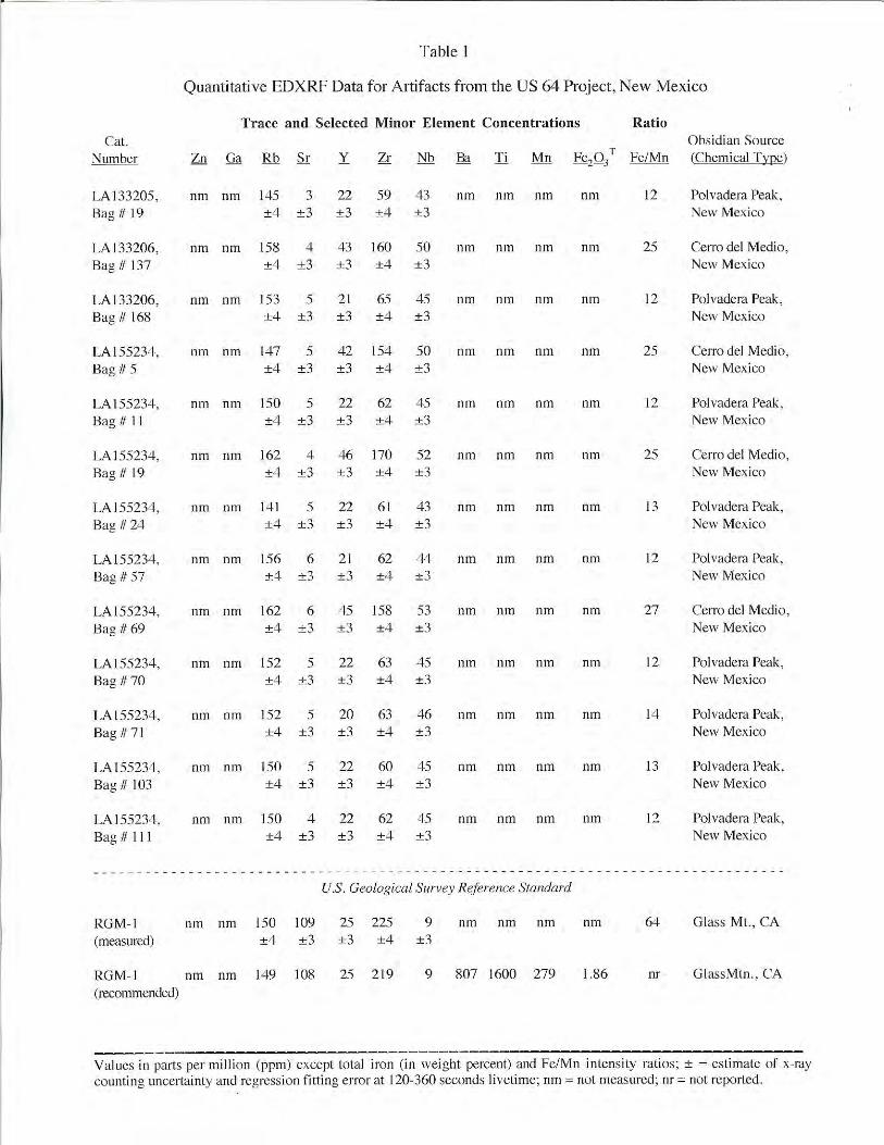

APPENDIX G:
LIST AND DESCRIPTIONS OF COLLECTIONS
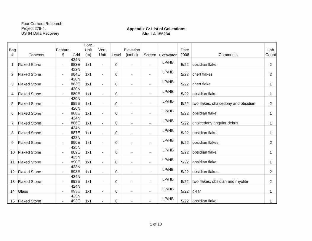
Four Corners ResearchProject 278-4,US 64 Data Recovery
Appendix G: List of CollectionsSite LA 155234
Bag# Contents
Feature# Grid
Horz.Unit(m)
Vert.Unit Level
Elevation (cmbd) Screen Excavator
Date2008 Comments
Lab Count
1 Flaked Stone -424N883E 1x1 - 0 - - LP/HB 5/22 obsidian flake 2
2 Flaked Stone -422N884E 1x1 - 0 - - LP/HB 5/22 chert flakes 2
3 Flaked Stone -420N883E 1x1 - 0 - - LP/HB 5/22 chert flake 1
4 Flaked Stone -420N880E 1x1 - 0 - - LP/HB 5/22 obsidian flake 1
5 Flaked Stone -420N885E 1x1 - 0 - - LP/HB 5/22 two flakes, chalcedony and obsidian 2
6 Flaked Stone -420N888E 1x1 - 0 - - LP/HB 5/22 obsidian flake 1
7 Flaked Stone -424N886E 1x1 - 0 - - LP/HB 5/22 chalcedony angular debris 1
8 Flaked Stone -424N887E 1x1 - 0 - - LP/HB 5/22 obsidian flake 1
9 Flaked Stone -423N890E 1x1 - 0 - - LP/HB 5/22 obsidian flakes 2
10 Flaked Stone -425N889E 1x1 - 0 - - LP/HB 5/22 obsidian flake 1
11 Flaked Stone -425N890E 1x1 - 0 - - LP/HB 5/22 obsidian flake 1
12 Flaked Stone -423N893E 1x1 - 0 - - LP/HB 5/22 obsidian flakes 2
13 Flaked Stone -424N893E 1x1 - 0 - - LP/HB 5/22 two flakes, obsidian and rhyolite 2
14 Glass -424N893E 1x1 - 0 - - LP/HB 5/22 clear 1
15 Flaked Stone -425N493E 1x1 - 0 - - LP/HB 5/22 obsidian flake 1
1 of 10
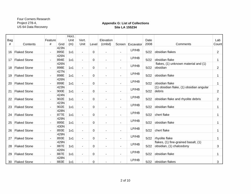
Four Corners ResearchProject 278-4,US 64 Data Recovery
Appendix G: List of CollectionsSite LA 155234
Bag# Contents
Feature# Grid
Horz.Unit(m)
Vert.Unit Level
Elevation (cmbd) Screen Excavator
Date2008 Comments
Lab Count
16 Flaked Stone -423N895E 1x1 - 0 - - LP/HB 5/22 obsidian flakes 2
17 Flaked Stone -426N894E 1x1 - 0 - - LP/HB 5/22 obsidian flake 1
18 Flaked Stone -426N898E 1x1 - 0 - - LP/HB 5/22
flakes, (1) unknown material and (1) obsidian 2
19 Flaked Stone -427N898E 1x1 - 0 - - LP/HB 5/22 obsidian flake 1
20 Flaked Stone -426N899E 1x1 - 0 - - LP/HB 5/22 obsidian flake 1
21 Flaked Stone -423N900E 1x1 - 0 - - LP/HB 5/22
(1) obsidian flake, (1) obsidian angular debris 2
22 Flaked Stone -424N902E 1x1 - 0 - - LP/HB 5/22 obsidian flake and rhyolite debris 2
23 Flaked Stone -423N902E 1x1 - 0 - - LP/HB 5/22 obsidian flake 1
24 Flaked Stone -428N877E 1x1 - 0 - - LP/HB 5/22 chert flake 1
25 Flaked Stone -429N895E 1x1 - 0 - - LP/HB 5/22 obsidian flake 1
26 Flaked Stone -430N893E 1x1 - 0 - - LP/HB 5/22 chert flake 1
27 Flaked Stone -429N893E 1x1 - 0 - - LP/HB 5/22 rhyolite flake 1
28 Flaked Stone -429N887E 1x1 - 0 - - LP/HB 5/22
flakes, (1) fine-grained basalt, (1) obsidian, (1) chalcedony 3
29 Flaked Stone -426N887E 1x1 - 0 - - LP/HB 5/22 obsidian flake 1
30 Flaked Stone -428N883E 1x1 - 0 - - LP/HB 5/22 obsidian flakes 3
2 of 10
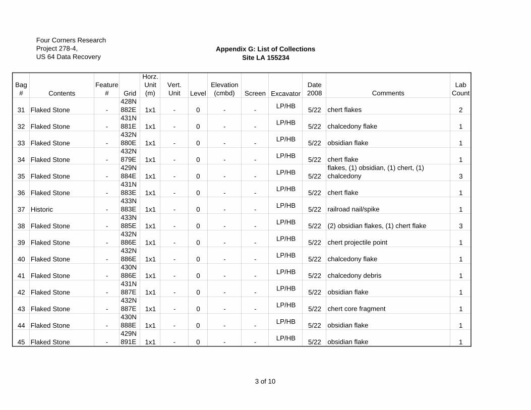
Four Corners ResearchProject 278-4,US 64 Data Recovery
Appendix G: List of CollectionsSite LA 155234
Bag# Contents
Feature# Grid
Horz.Unit(m)
Vert.Unit Level
Elevation (cmbd) Screen Excavator
Date2008 Comments
Lab Count
31 Flaked Stone -428N882E 1x1 - 0 - - LP/HB 5/22 chert flakes 2
32 Flaked Stone -431N881E 1x1 - 0 - - LP/HB 5/22 chalcedony flake 1
33 Flaked Stone -432N880E 1x1 - 0 - - LP/HB 5/22 obsidian flake 1
34 Flaked Stone -432N879E 1x1 - 0 - - LP/HB 5/22 chert flake 1
35 Flaked Stone -429N884E 1x1 - 0 - - LP/HB 5/22
flakes, (1) obsidian, (1) chert, (1) chalcedony 3
36 Flaked Stone -431N883E 1x1 - 0 - - LP/HB 5/22 chert flake 1
37 Historic -433N883E 1x1 - 0 - - LP/HB 5/22 railroad nail/spike 1
38 Flaked Stone -433N885E 1x1 - 0 - - LP/HB 5/22 (2) obsidian flakes, (1) chert flake 3
39 Flaked Stone -432N886E 1x1 - 0 - - LP/HB 5/22 chert projectile point 1
40 Flaked Stone -432N886E 1x1 - 0 - - LP/HB 5/22 chalcedony flake 1
41 Flaked Stone -430N886E 1x1 - 0 - - LP/HB 5/22 chalcedony debris 1
42 Flaked Stone -431N887E 1x1 - 0 - - LP/HB 5/22 obsidian flake 1
43 Flaked Stone -432N887E 1x1 - 0 - - LP/HB 5/22 chert core fragment 1
44 Flaked Stone -430N888E 1x1 - 0 - - LP/HB 5/22 obsidian flake 1
45 Flaked Stone -429N891E 1x1 - 0 - - LP/HB 5/22 obsidian flake 1
3 of 10
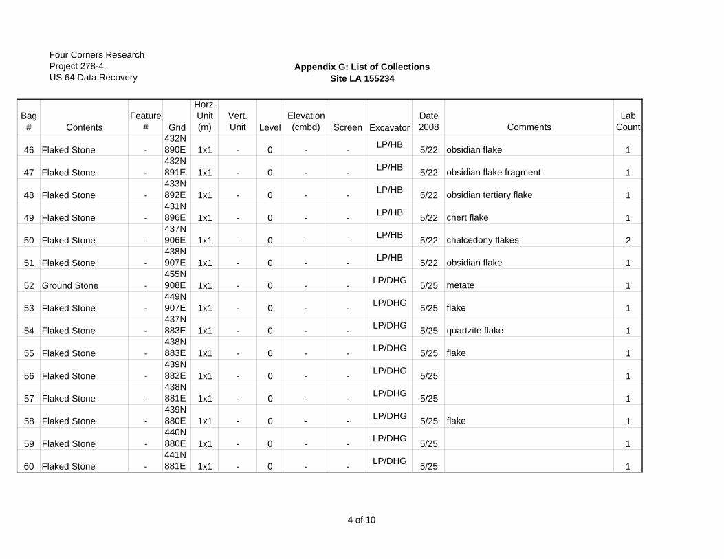
Four Corners ResearchProject 278-4,US 64 Data Recovery
Appendix G: List of CollectionsSite LA 155234
Bag# Contents
Feature# Grid
Horz.Unit(m)
Vert.Unit Level
Elevation (cmbd) Screen Excavator
Date2008 Comments
Lab Count
46 Flaked Stone -432N890E 1x1 - 0 - - LP/HB 5/22 obsidian flake 1
47 Flaked Stone -432N891E 1x1 - 0 - - LP/HB 5/22 obsidian flake fragment 1
48 Flaked Stone -433N892E 1x1 - 0 - - LP/HB 5/22 obsidian tertiary flake 1
49 Flaked Stone -431N896E 1x1 - 0 - - LP/HB 5/22 chert flake 1
50 Flaked Stone -437N906E 1x1 - 0 - - LP/HB 5/22 chalcedony flakes 2
51 Flaked Stone -438N907E 1x1 - 0 - - LP/HB 5/22 obsidian flake 1
52 Ground Stone -455N908E 1x1 - 0 - - LP/DHG 5/25 metate 1
53 Flaked Stone -449N907E 1x1 - 0 - - LP/DHG 5/25 flake 1
54 Flaked Stone -437N883E 1x1 - 0 - - LP/DHG 5/25 quartzite flake 1
55 Flaked Stone -438N883E 1x1 - 0 - - LP/DHG 5/25 flake 1
56 Flaked Stone -439N882E 1x1 - 0 - - LP/DHG 5/25 1
57 Flaked Stone -438N881E 1x1 - 0 - - LP/DHG 5/25 1
58 Flaked Stone -439N880E 1x1 - 0 - - LP/DHG 5/25 flake 1
59 Flaked Stone -440N880E 1x1 - 0 - - LP/DHG 5/25 1
60 Flaked Stone -441N881E 1x1 - 0 - - LP/DHG 5/25 1
4 of 10
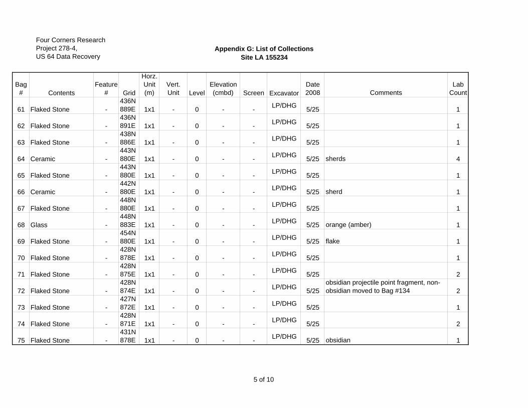
Four Corners ResearchProject 278-4,US 64 Data Recovery
Appendix G: List of CollectionsSite LA 155234
Bag# Contents
Feature# Grid
Horz.Unit(m)
Vert.Unit Level
Elevation (cmbd) Screen Excavator
Date2008 Comments
Lab Count
61 Flaked Stone -436N889E 1x1 - 0 - - LP/DHG 5/25 1
62 Flaked Stone -436N891E 1x1 - 0 - - LP/DHG 5/25 1
63 Flaked Stone -438N886E 1x1 - 0 - - LP/DHG 5/25 1
64 Ceramic -443N880E 1x1 - 0 - - LP/DHG 5/25 sherds 4
65 Flaked Stone -443N880E 1x1 - 0 - - LP/DHG 5/25 1
66 Ceramic -442N880E 1x1 - 0 - - LP/DHG 5/25 sherd 1
67 Flaked Stone -448N880E 1x1 - 0 - - LP/DHG 5/25 1
68 Glass -448N883E 1x1 - 0 - - LP/DHG 5/25 orange (amber) 1
69 Flaked Stone -454N880E 1x1 - 0 - - LP/DHG 5/25 flake 1
70 Flaked Stone -428N878E 1x1 - 0 - - LP/DHG 5/25 1
71 Flaked Stone -428N875E 1x1 - 0 - - LP/DHG 5/25 2
72 Flaked Stone -428N874E 1x1 - 0 - - LP/DHG 5/25
obsidian projectile point fragment, non-obsidian moved to Bag #134 2
73 Flaked Stone -427N872E 1x1 - 0 - - LP/DHG 5/25 1
74 Flaked Stone -428N871E 1x1 - 0 - - LP/DHG 5/25 2
75 Flaked Stone -431N878E 1x1 - 0 - - LP/DHG 5/25 obsidian 1
5 of 10
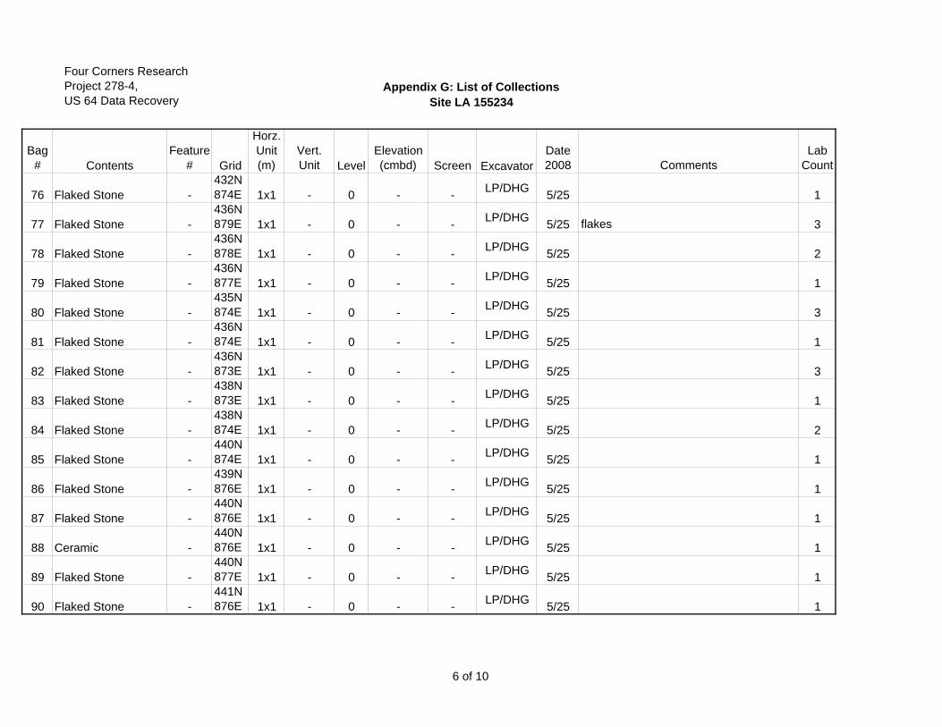
Four Corners ResearchProject 278-4,US 64 Data Recovery
Appendix G: List of CollectionsSite LA 155234
Bag# Contents
Feature# Grid
Horz.Unit(m)
Vert.Unit Level
Elevation (cmbd) Screen Excavator
Date2008 Comments
Lab Count
76 Flaked Stone -432N874E 1x1 - 0 - - LP/DHG 5/25 1
77 Flaked Stone -436N879E 1x1 - 0 - - LP/DHG 5/25 flakes 3
78 Flaked Stone -436N878E 1x1 - 0 - - LP/DHG 5/25 2
79 Flaked Stone -436N877E 1x1 - 0 - - LP/DHG 5/25 1
80 Flaked Stone -435N874E 1x1 - 0 - - LP/DHG 5/25 3
81 Flaked Stone -436N874E 1x1 - 0 - - LP/DHG 5/25 1
82 Flaked Stone -436N873E 1x1 - 0 - - LP/DHG 5/25 3
83 Flaked Stone -438N873E 1x1 - 0 - - LP/DHG 5/25 1
84 Flaked Stone -438N874E 1x1 - 0 - - LP/DHG 5/25 2
85 Flaked Stone -440N874E 1x1 - 0 - - LP/DHG 5/25 1
86 Flaked Stone -439N876E 1x1 - 0 - - LP/DHG 5/25 1
87 Flaked Stone -440N876E 1x1 - 0 - - LP/DHG 5/25 1
88 Ceramic -440N876E 1x1 - 0 - - LP/DHG 5/25 1
89 Flaked Stone -440N877E 1x1 - 0 - - LP/DHG 5/25 1
90 Flaked Stone -441N876E 1x1 - 0 - - LP/DHG 5/25 1
6 of 10
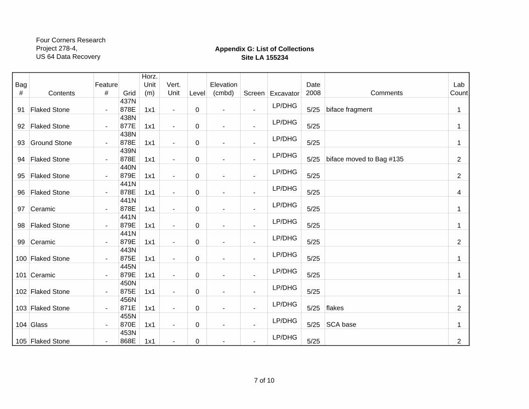
Four Corners ResearchProject 278-4,US 64 Data Recovery
Appendix G: List of CollectionsSite LA 155234
Bag# Contents
Feature# Grid
Horz.Unit(m)
Vert.Unit Level
Elevation (cmbd) Screen Excavator
Date2008 Comments
Lab Count
91 Flaked Stone -437N878E 1x1 - 0 - - LP/DHG 5/25 biface fragment 1
92 Flaked Stone -438N877E 1x1 - 0 - - LP/DHG 5/25 1
93 Ground Stone -438N878E 1x1 - 0 - - LP/DHG 5/25 1
94 Flaked Stone -439N878E 1x1 - 0 - - LP/DHG 5/25 biface moved to Bag #135 2
95 Flaked Stone -440N879E 1x1 - 0 - - LP/DHG 5/25 2
96 Flaked Stone -441N878E 1x1 - 0 - - LP/DHG 5/25 4
97 Ceramic -441N878E 1x1 - 0 - - LP/DHG 5/25 1
98 Flaked Stone -441N879E 1x1 - 0 - - LP/DHG 5/25 1
99 Ceramic -441N879E 1x1 - 0 - - LP/DHG 5/25 2
100 Flaked Stone -443N875E 1x1 - 0 - - LP/DHG 5/25 1
101 Ceramic -445N879E 1x1 - 0 - - LP/DHG 5/25 1
102 Flaked Stone -450N875E 1x1 - 0 - - LP/DHG 5/25 1
103 Flaked Stone -456N871E 1x1 - 0 - - LP/DHG 5/25 flakes 2
104 Glass -455N870E 1x1 - 0 - - LP/DHG 5/25 SCA base 1
105 Flaked Stone -453N868E 1x1 - 0 - - LP/DHG 5/25 2
7 of 10
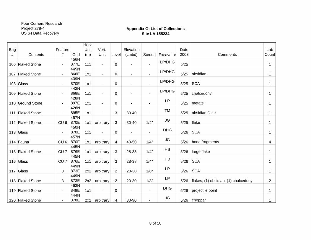
Four Corners ResearchProject 278-4,US 64 Data Recovery
Appendix G: List of CollectionsSite LA 155234
Bag# Contents
Feature# Grid
Horz.Unit(m)
Vert.Unit Level
Elevation (cmbd) Screen Excavator
Date2008 Comments
Lab Count
106 Flaked Stone -456N877E 1x1 - 0 - - LP/DHG 5/25 1
107 Flaked Stone -445N866E 1x1 - 0 - - LP/DHG 5/25 obsidian 1
108 Glass -439N870E 1x1 - 0 - - LP/DHG 5/25 SCA 1
109 Flaked Stone -442N868E 1x1 - 0 - - LP/DHG 5/25 chalcedony 1
110 Ground Stone -428N897E 1x1 - 0 - - LP 5/25 metate 1
111 Flaked Stone -426N895E 1x1 - 3 30-40 - TM 5/25 obsidian flake 1
112 Flaked Stone CU 6457N870E 1x1 arbitrary 3 30-40 1/4" JG 5/25 flake 1
113 Glass -450N870E 1x1 - 0 - - DHG 5/26 SCA 1
114 Fauna CU 6457N870E 1x1 arbitrary 4 40-50 1/4" JG 5/26 bone fragments 4
115 Flaked Stone CU 7445N876E 1x1 arbitrary 3 28-38 1/4" HB 5/26 large flake 1
116 Glass CU 7445N876E 1x1 arbitrary 3 28-38 1/4" HB 5/26 SCA 1
117 Glass 3449N873E 2x2 arbitrary 2 20-30 1/8" LP 5/26 SCA 1
118 Flaked Stone 3449N873E 2x2 arbitrary 2 20-30 1/8" LP 5/26 flakes, (1) obsidian, (1) chalcedony 2
119 Flaked Stone -463N849E 1x1 - 0 - - DHG 5/26 projectile point 1
120 Flaked Stone -444N378E 2x2 arbitrary 4 80-90 - JG 5/26 chopper 1
8 of 10
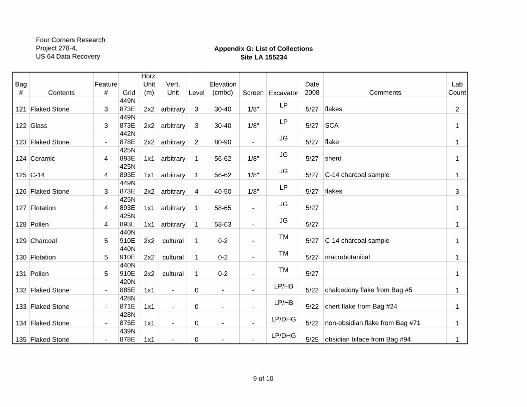
Four Corners ResearchProject 278-4,US 64 Data Recovery
Appendix G: List of CollectionsSite LA 155234
Bag# Contents
Feature# Grid
Horz.Unit(m)
Vert.Unit Level
Elevation (cmbd) Screen Excavator
Date2008 Comments
Lab Count
121 Flaked Stone 3449N873E 2x2 arbitrary 3 30-40 1/8" LP 5/27 flakes 2
122 Glass 3449N873E 2x2 arbitrary 3 30-40 1/8" LP 5/27 SCA 1
123 Flaked Stone -442N878E 2x2 arbitrary 2 80-90 - JG 5/27 flake 1
124 Ceramic 4425N893E 1x1 arbitrary 1 56-62 1/8" JG 5/27 sherd 1
125 C-14 4425N893E 1x1 arbitrary 1 56-62 1/8" JG 5/27 C-14 charcoal sample 1
126 Flaked Stone 3449N873E 2x2 arbitrary 4 40-50 1/8" LP 5/27 flakes 3
127 Flotation 4425N893E 1x1 arbitrary 1 58-65 - JG 5/27 1
128 Pollen 4425N893E 1x1 arbitrary 1 58-63 - JG 5/27 1
129 Charcoal 5440N910E 2x2 cultural 1 0-2 - TM 5/27 C-14 charcoal sample 1
130 Flotation 5440N910E 2x2 cultural 1 0-2 - TM 5/27 macrobotanical 1
131 Pollen 5440N910E 2x2 cultural 1 0-2 - TM 5/27 1
132 Flaked Stone -420N885E 1x1 - 0 - - LP/HB 5/22 chalcedony flake from Bag #5 1
133 Flaked Stone -428N871E 1x1 - 0 - - LP/HB 5/22 chert flake from Bag #24 1
134 Flaked Stone -428N875E 1x1 - 0 - - LP/DHG 5/22 non-obsidian flake from Bag #71 1
135 Flaked Stone -439N878E 1x1 - 0 - - LP/DHG 5/25 obsidian biface from Bag #94 1
9 of 10

Four Corners ResearchProject 278-4,US 64 Data Recovery
Appendix G: List of CollectionsSite LA 155234
Bag# Contents
Feature# Grid
Horz.Unit(m)
Vert.Unit Level
Elevation (cmbd) Screen Excavator
Date2008 Comments
Lab Count
137 Flaked Stone 3449N873E 2x2 arbitrary 4 40-50 1/8" LP/HB 5/27 obsidian flake from Bag #126 1
10 of 10
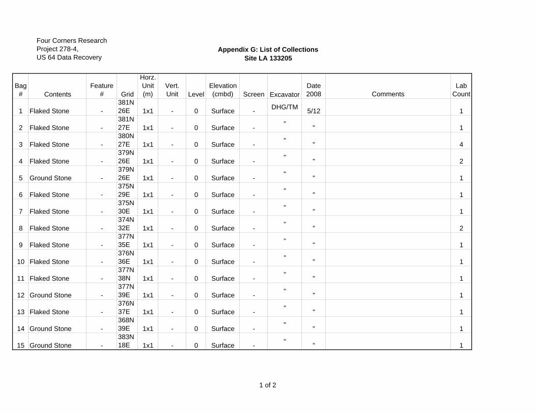
Four Corners ResearchProject 278-4,US 64 Data Recovery
Appendix G: List of CollectionsSite LA 133205
Bag# Contents
Feature# Grid
Horz.Unit(m)
Vert.Unit Level
Elevation (cmbd) Screen Excavator
Date2008 Comments
Lab Count
1 Flaked Stone -381N26E 1x1 - 0 Surface - DHG/TM 5/12 1
2 Flaked Stone -381N27E 1x1 - 0 Surface - " " 1
3 Flaked Stone -380N27E 1x1 - 0 Surface - " " 4
4 Flaked Stone -379N26E 1x1 - 0 Surface - " " 2
5 Ground Stone -379N26E 1x1 - 0 Surface - " " 1
6 Flaked Stone -375N29E 1x1 - 0 Surface - " " 1
7 Flaked Stone -375N30E 1x1 - 0 Surface - " " 1
8 Flaked Stone -374N32E 1x1 - 0 Surface - " " 2
9 Flaked Stone -377N35E 1x1 - 0 Surface - " " 1
10 Flaked Stone -376N36E 1x1 - 0 Surface - " " 1
11 Flaked Stone -377N38N 1x1 - 0 Surface - " " 1
12 Ground Stone -377N39E 1x1 - 0 Surface - " " 1
13 Flaked Stone -376N37E 1x1 - 0 Surface - " " 1
14 Ground Stone -368N39E 1x1 - 0 Surface - " " 1
15 Ground Stone -383N18E 1x1 - 0 Surface - " " 1
1 of 2
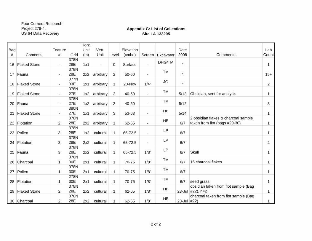
Four Corners ResearchProject 278-4,US 64 Data Recovery
Appendix G: List of CollectionsSite LA 133205
Bag# Contents
Feature# Grid
Horz.Unit(m)
Vert.Unit Level
Elevation (cmbd) Screen Excavator
Date2008 Comments
Lab Count
16 Flaked Stone -378N28E 1x1 - 0 Surface - DHG/TM " 1
17 Fauna -378N28E 2x2 arbitrary 2 50-60 - TM " 15+
18 Flaked Stone -377N33E 1x1 arbitrary 1 20-Nov 1/4" JG " 2
19 Flaked Stone -378N27E 1x2 arbitrary 2 40-50 - TM 5/13 Obsidian, sent for analysis 1
20 Fauna -378N27E 1x2 arbitrary 2 40-50 - TM 5/12 3
21 Flaked Stone -380N27E 1x1 arbitrary 3 53-63 - HB 5/14 1
22 Flotation 2378N28E 2x2 arbitrary 1 62-65 - HB 6/7
2 obsidian flakes & charcoal sample taken from flot (bags #29-30) 1
23 Pollen 3378N28E 1x2 cultural 1 65-72.5 - LP 6/7 1
24 Flotation 3378N28E 2x2 cultural 1 65-72.5 - LP 6/7 2
25 Fauna 3378N28E 2x2 cultural 1 65-72.5 1/8" LP 6/7 Skull 1
26 Charcoal 1378N30E 2x1 cultural 1 70-75 1/8" TM 6/7 15 charcoal flakes 1
27 Pollen 1378N30E 2x1 cultural 1 70-75 1/8" TM 6/7 1
28 Flotation 1278N30E 2x1 cultural 1 70-75 1/8" TM 6/7 seed grass 1
29 Flaked Stone 2378N28E 2x2 cultural 1 62-65 1/8" HB 23-Jul
obsidian taken from flot sample (Bag #22), n=2 1
30 Charcoal 2378N28E 2x2 cultural 1 62-65 1/8" HB 23-Jul
charcoal taken from flot sample (Bag #22) 1
2 of 2
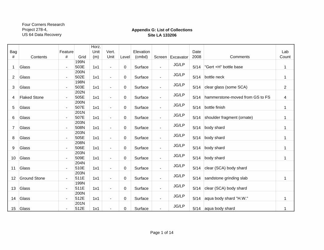
Four Corners ResearchProject 278-4,US 64 Data Recovery
Appendix G: List of CollectionsSite LA 133206
Bag# Contents
Feature# Grid
Horz.Unit(m)
Vert.Unit Level
Elevation (cmbd) Screen Excavator
Date2008 Comments
Lab Count
1 Glass -199N503E 1x1 - 0 Surface - JG/LP 5/14 "Gert +H" bottle base 1
2 Glass -200N502E 1x1 - 0 Surface - JG/LP 5/14 bottle neck 1
3 Glass -198N503E 1x1 - 0 Surface - JG/LP 5/14 clear glass (some SCA) 2
4 Flaked Stone -202N505E 1x1 - 0 Surface - JG/LP 5/14 hammerstone-moved from GS to FS 4
5 Glass -200N507E 1x1 - 0 Surface - JG/LP 5/14 bottle finish 1
6 Glass -201N507E 1x1 - 0 Surface - JG/LP 5/14 shoulder fragment (ornate) 1
7 Glass -203N508N 1x1 - 0 Surface - JG/LP 5/14 body shard 1
8 Glass -203N505E 1x1 - 0 Surface - JG/LP 5/14 body shard 1
9 Glass -208N506E 1x1 - 0 Surface - JG/LP 5/14 body shard 1
10 Glass -203N509E 1x1 - 0 Surface - JG/LP 5/14 body shard 1
11 Glass -204N510E 1x1 - 0 Surface - JG/LP 5/14 clear (SCA) body shard
12 Ground Stone -203N511E 1x1 - 0 Surface - JG/LP 5/14 sandstone grinding slab 1
13 Glass -199N511E 1x1 - 0 Surface - JG/LP 5/14 clear (SCA) body shard
14 Glass -200N512E 1x1 - 0 Surface - JG/LP 5/14 aqua body shard "H.W." 1
15 Glass -201N512E 1x1 - 0 Surface - JG/LP 5/14 aqua body shard 1
Page 1 of 14
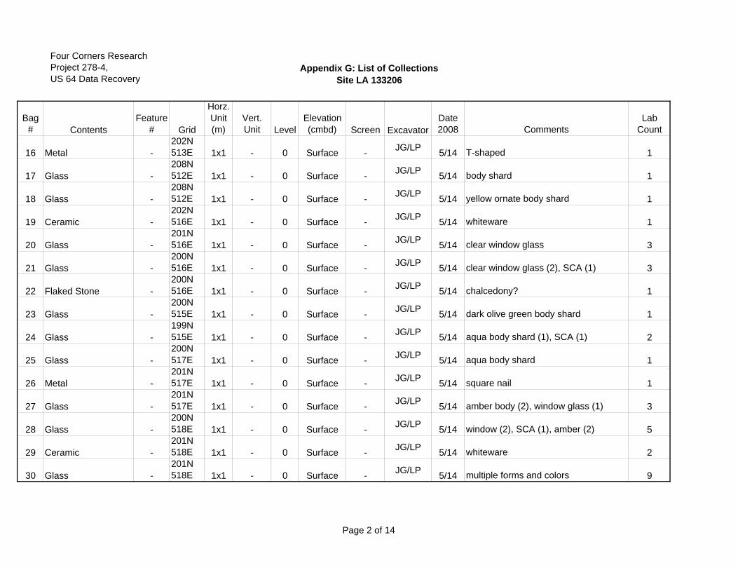
Four Corners ResearchProject 278-4,US 64 Data Recovery
Appendix G: List of CollectionsSite LA 133206
Bag# Contents
Feature# Grid
Horz.Unit(m)
Vert.Unit Level
Elevation (cmbd) Screen Excavator
Date2008 Comments
Lab Count
16 Metal -202N513E 1x1 - 0 Surface - JG/LP 5/14 T-shaped 1
17 Glass -208N512E 1x1 - 0 Surface - JG/LP 5/14 body shard 1
18 Glass -208N512E 1x1 - 0 Surface - JG/LP 5/14 yellow ornate body shard 1
19 Ceramic -202N516E 1x1 - 0 Surface - JG/LP 5/14 whiteware 1
20 Glass -201N516E 1x1 - 0 Surface - JG/LP 5/14 clear window glass 3
21 Glass -200N516E 1x1 - 0 Surface - JG/LP 5/14 clear window glass (2), SCA (1) 3
22 Flaked Stone -200N516E 1x1 - 0 Surface - JG/LP 5/14 chalcedony? 1
23 Glass -200N515E 1x1 - 0 Surface - JG/LP 5/14 dark olive green body shard 1
24 Glass -199N515E 1x1 - 0 Surface - JG/LP 5/14 aqua body shard (1), SCA (1) 2
25 Glass -200N517E 1x1 - 0 Surface - JG/LP 5/14 aqua body shard 1
26 Metal -201N517E 1x1 - 0 Surface - JG/LP 5/14 square nail 1
27 Glass -201N517E 1x1 - 0 Surface - JG/LP 5/14 amber body (2), window glass (1) 3
28 Glass -200N518E 1x1 - 0 Surface - JG/LP 5/14 window (2), SCA (1), amber (2) 5
29 Ceramic -201N518E 1x1 - 0 Surface - JG/LP 5/14 whiteware 2
30 Glass -201N518E 1x1 - 0 Surface - JG/LP 5/14 multiple forms and colors 9
Page 2 of 14
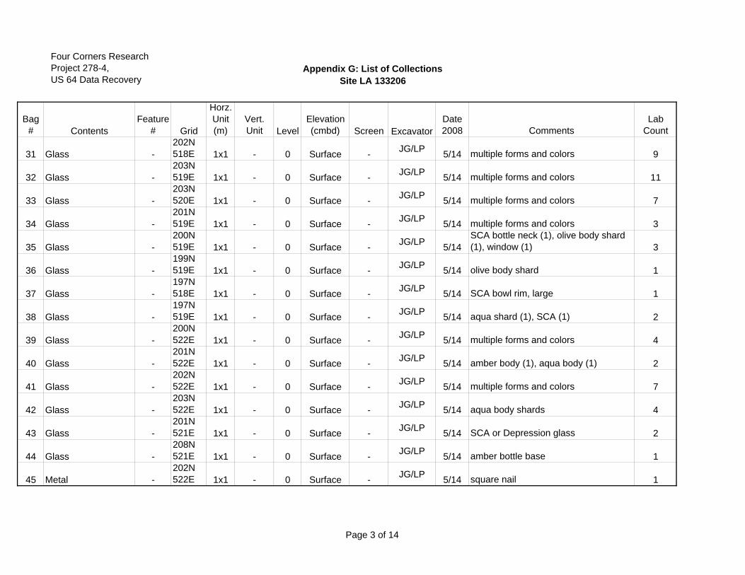
Four Corners ResearchProject 278-4,US 64 Data Recovery
Appendix G: List of CollectionsSite LA 133206
Bag# Contents
Feature# Grid
Horz.Unit(m)
Vert.Unit Level
Elevation (cmbd) Screen Excavator
Date2008 Comments
Lab Count
31 Glass -202N518E 1x1 - 0 Surface - JG/LP 5/14 multiple forms and colors 9
32 Glass -203N519E 1x1 - 0 Surface - JG/LP 5/14 multiple forms and colors 11
33 Glass -203N520E 1x1 - 0 Surface - JG/LP 5/14 multiple forms and colors 7
34 Glass -201N519E 1x1 - 0 Surface - JG/LP 5/14 multiple forms and colors 3
35 Glass -200N519E 1x1 - 0 Surface - JG/LP 5/14
SCA bottle neck (1), olive body shard (1), window (1) 3
36 Glass -199N519E 1x1 - 0 Surface - JG/LP 5/14 olive body shard 1
37 Glass -197N518E 1x1 - 0 Surface - JG/LP 5/14 SCA bowl rim, large 1
38 Glass -197N519E 1x1 - 0 Surface - JG/LP 5/14 aqua shard (1), SCA (1) 2
39 Glass -200N522E 1x1 - 0 Surface - JG/LP 5/14 multiple forms and colors 4
40 Glass -201N522E 1x1 - 0 Surface - JG/LP 5/14 amber body (1), aqua body (1) 2
41 Glass -202N522E 1x1 - 0 Surface - JG/LP 5/14 multiple forms and colors 7
42 Glass -203N522E 1x1 - 0 Surface - JG/LP 5/14 aqua body shards 4
43 Glass -201N521E 1x1 - 0 Surface - JG/LP 5/14 SCA or Depression glass 2
44 Glass -208N521E 1x1 - 0 Surface - JG/LP 5/14 amber bottle base 1
45 Metal -202N522E 1x1 - 0 Surface - JG/LP 5/14 square nail 1
Page 3 of 14
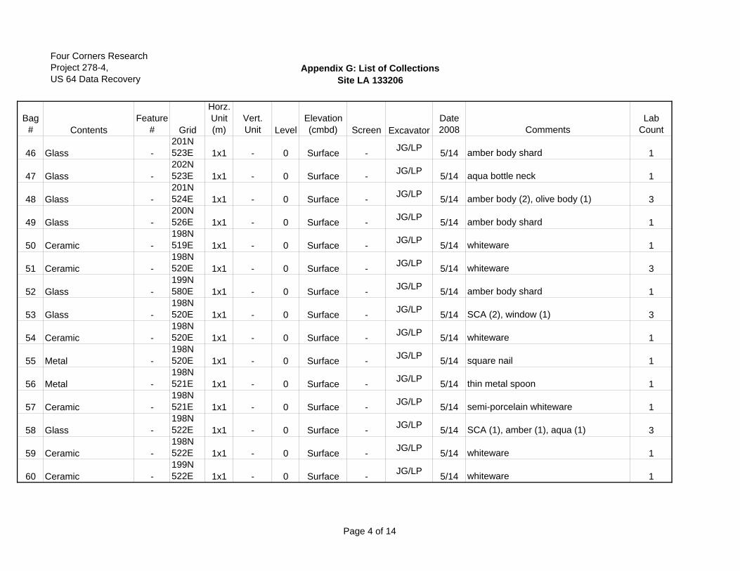
Four Corners ResearchProject 278-4,US 64 Data Recovery
Appendix G: List of CollectionsSite LA 133206
Bag# Contents
Feature# Grid
Horz.Unit(m)
Vert.Unit Level
Elevation (cmbd) Screen Excavator
Date2008 Comments
Lab Count
46 Glass -201N523E 1x1 - 0 Surface - JG/LP 5/14 amber body shard 1
47 Glass -202N523E 1x1 - 0 Surface - JG/LP 5/14 aqua bottle neck 1
48 Glass -201N524E 1x1 - 0 Surface - JG/LP 5/14 amber body (2), olive body (1) 3
49 Glass -200N526E 1x1 - 0 Surface - JG/LP 5/14 amber body shard 1
50 Ceramic -198N519E 1x1 - 0 Surface - JG/LP 5/14 whiteware 1
51 Ceramic -198N520E 1x1 - 0 Surface - JG/LP 5/14 whiteware 3
52 Glass -199N580E 1x1 - 0 Surface - JG/LP 5/14 amber body shard 1
53 Glass -198N520E 1x1 - 0 Surface - JG/LP 5/14 SCA (2), window (1) 3
54 Ceramic -198N520E 1x1 - 0 Surface - JG/LP 5/14 whiteware 1
55 Metal -198N520E 1x1 - 0 Surface - JG/LP 5/14 square nail 1
56 Metal -198N521E 1x1 - 0 Surface - JG/LP 5/14 thin metal spoon 1
57 Ceramic -198N521E 1x1 - 0 Surface - JG/LP 5/14 semi-porcelain whiteware 1
58 Glass -198N522E 1x1 - 0 Surface - JG/LP 5/14 SCA (1), amber (1), aqua (1) 3
59 Ceramic -198N522E 1x1 - 0 Surface - JG/LP 5/14 whiteware 1
60 Ceramic -199N522E 1x1 - 0 Surface - JG/LP 5/14 whiteware 1
Page 4 of 14
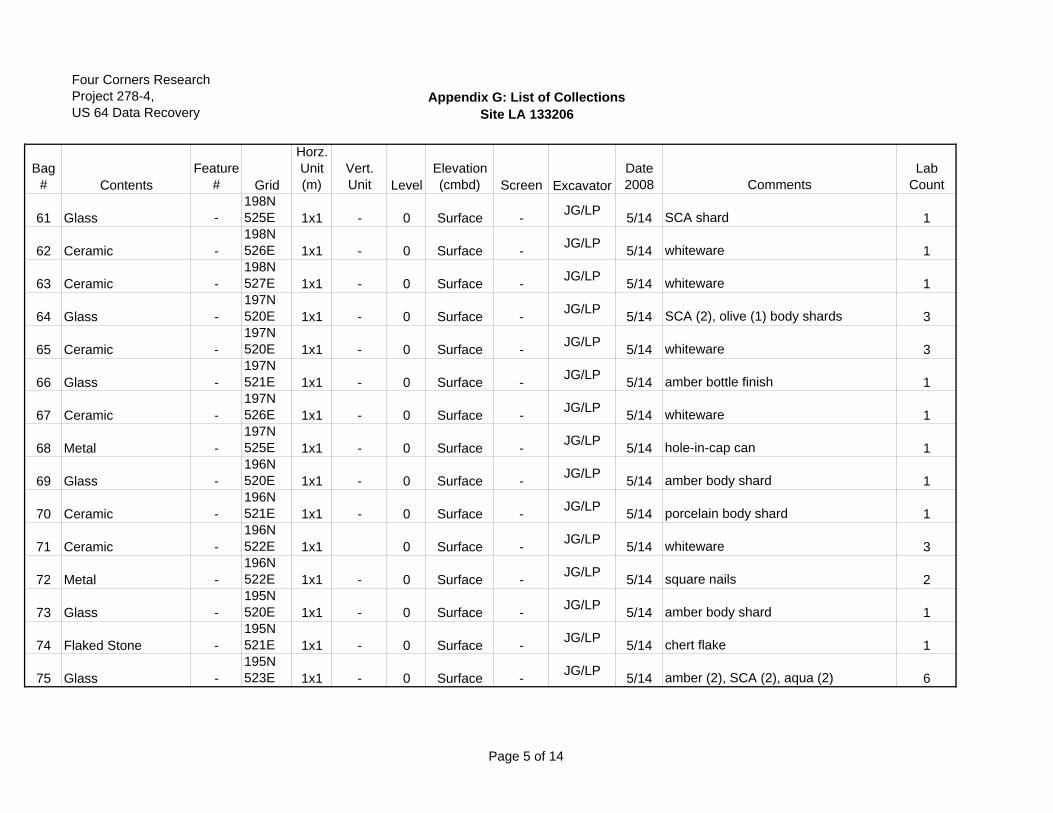
Four Corners ResearchProject 278-4,US 64 Data Recovery
Appendix G: List of CollectionsSite LA 133206
Bag# Contents
Feature# Grid
Horz.Unit(m)
Vert.Unit Level
Elevation (cmbd) Screen Excavator
Date2008 Comments
Lab Count
61 Glass -198N525E 1x1 - 0 Surface - JG/LP 5/14 SCA shard 1
62 Ceramic -198N526E 1x1 - 0 Surface - JG/LP 5/14 whiteware 1
63 Ceramic -198N527E 1x1 - 0 Surface - JG/LP 5/14 whiteware 1
64 Glass -197N520E 1x1 - 0 Surface - JG/LP 5/14 SCA (2), olive (1) body shards 3
65 Ceramic -197N520E 1x1 - 0 Surface - JG/LP 5/14 whiteware 3
66 Glass -197N521E 1x1 - 0 Surface - JG/LP 5/14 amber bottle finish 1
67 Ceramic -197N526E 1x1 - 0 Surface - JG/LP 5/14 whiteware 1
68 Metal -197N525E 1x1 - 0 Surface - JG/LP 5/14 hole-in-cap can 1
69 Glass -196N520E 1x1 - 0 Surface - JG/LP 5/14 amber body shard 1
70 Ceramic -196N521E 1x1 - 0 Surface - JG/LP 5/14 porcelain body shard 1
71 Ceramic -196N522E 1x1 0 Surface - JG/LP 5/14 whiteware 3
72 Metal -196N522E 1x1 - 0 Surface - JG/LP 5/14 square nails 2
73 Glass -195N520E 1x1 - 0 Surface - JG/LP 5/14 amber body shard 1
74 Flaked Stone -195N521E 1x1 - 0 Surface - JG/LP 5/14 chert flake 1
75 Glass -195N523E 1x1 - 0 Surface - JG/LP 5/14 amber (2), SCA (2), aqua (2) 6
Page 5 of 14
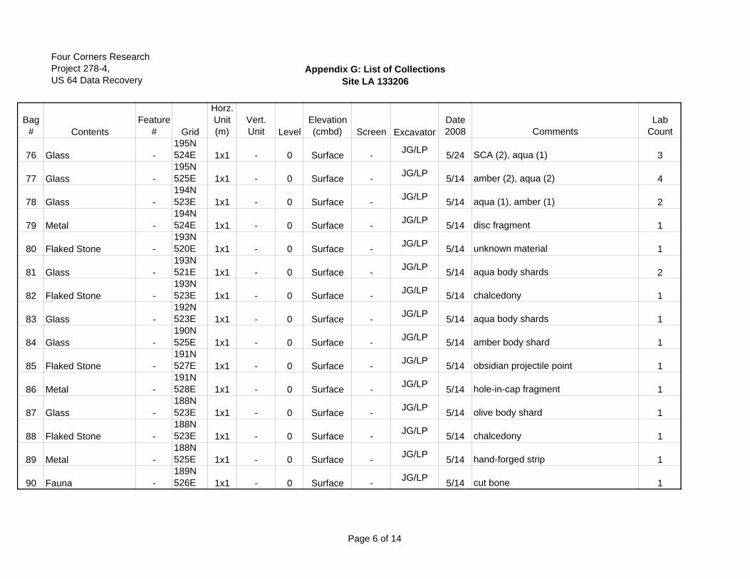
Four Corners ResearchProject 278-4,US 64 Data Recovery
Appendix G: List of CollectionsSite LA 133206
Bag# Contents
Feature# Grid
Horz.Unit(m)
Vert.Unit Level
Elevation (cmbd) Screen Excavator
Date2008 Comments
Lab Count
76 Glass -195N524E 1x1 - 0 Surface - JG/LP 5/24 SCA (2), aqua (1) 3
77 Glass -195N525E 1x1 - 0 Surface - JG/LP 5/14 amber (2), aqua (2) 4
78 Glass -194N523E 1x1 - 0 Surface - JG/LP 5/14 aqua (1), amber (1) 2
79 Metal -194N524E 1x1 - 0 Surface - JG/LP 5/14 disc fragment 1
80 Flaked Stone -193N520E 1x1 - 0 Surface - JG/LP 5/14 unknown material 1
81 Glass -193N521E 1x1 - 0 Surface - JG/LP 5/14 aqua body shards 2
82 Flaked Stone -193N523E 1x1 - 0 Surface - JG/LP 5/14 chalcedony 1
83 Glass -192N523E 1x1 - 0 Surface - JG/LP 5/14 aqua body shards 1
84 Glass -190N525E 1x1 - 0 Surface - JG/LP 5/14 amber body shard 1
85 Flaked Stone -191N527E 1x1 - 0 Surface - JG/LP 5/14 obsidian projectile point 1
86 Metal -191N528E 1x1 - 0 Surface - JG/LP 5/14 hole-in-cap fragment 1
87 Glass -188N523E 1x1 - 0 Surface - JG/LP 5/14 olive body shard 1
88 Flaked Stone -188N523E 1x1 - 0 Surface - JG/LP 5/14 chalcedony 1
89 Metal -188N525E 1x1 - 0 Surface - JG/LP 5/14 hand-forged strip 1
90 Fauna -189N526E 1x1 - 0 Surface - JG/LP 5/14 cut bone 1
Page 6 of 14
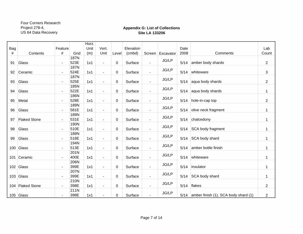
Four Corners ResearchProject 278-4,US 64 Data Recovery
Appendix G: List of CollectionsSite LA 133206
Bag# Contents
Feature# Grid
Horz.Unit(m)
Vert.Unit Level
Elevation (cmbd) Screen Excavator
Date2008 Comments
Lab Count
91 Glass -187N523E 1x1 - 0 Surface - JG/LP 5/14 amber body shards 2
92 Ceramic -187N524E 1x1 - 0 Surface - JG/LP 5/14 whiteware 3
93 Glass -187N525E 1x1 - 0 Surface - JG/LP 5/14 aqua body shards 2
94 Glass -185N522E 1x1 - 0 Surface - JG/LP 5/14 aqua body shards 1
95 Metal -186N528E 1x1 - 0 Surface - JG/LP 5/14 hole-in-cap top 2
96 Glass -189N581E 1x1 - 0 Surface - JG/LP 5/14 olive neck fragment 1
97 Flaked Stone -189N531E 1x1 - 0 Surface - JG/LP 5/14 chalcedony 1
98 Glass -190N510E 1x1 - 0 Surface - JG/LP 5/14 SCA body fragment 1
99 Glass -189N518E 1x1 - 0 Surface - JG/LP 5/14 SCA body shard 1
100 Glass -194N513E 1x1 - 0 Surface - JG/LP 5/14 amber bottle finish 1
101 Ceramic -201N400E 1x1 - 0 Surface - JG/LP 5/14 whiteware 1
102 Glass -206N399E 1x1 - 0 Surface - JG/LP 5/14 insulator 1
103 Glass -207N399E 1x1 - 0 Surface - JG/LP 5/14 SCA body shard 1
104 Flaked Stone -210N398E 1x1 - 0 Surface - JG/LP 5/14 flakes 2
105 Glass -211N398E 1x1 - 0 Surface - JG/LP 5/14 amber finish (1), SCA body shard (1) 2
Page 7 of 14
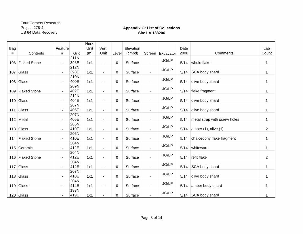
Four Corners ResearchProject 278-4,US 64 Data Recovery
Appendix G: List of CollectionsSite LA 133206
Bag# Contents
Feature# Grid
Horz.Unit(m)
Vert.Unit Level
Elevation (cmbd) Screen Excavator
Date2008 Comments
Lab Count
106 Flaked Stone -211N398E 1x1 - 0 Surface - JG/LP 5/14 whole flake 1
107 Glass -212N398E 1x1 - 0 Surface - JG/LP 5/14 SCA body shard 1
108 Glass -210N400E 1x1 - 0 Surface - JG/LP 5/14 olive body shard 1
109 Flaked Stone -209N402E 1x1 - 0 Surface - JG/LP 5/14 flake fragment 1
110 Glass -212N404E 1x1 - 0 Surface - JG/LP 5/14 olive body shard 1
111 Glass -207N405E 1x1 - 0 Surface - JG/LP 5/14 olive body shard 1
112 Metal -207N405E 1x1 - 0 Surface - JG/LP 5/14 metal strap with screw holes 1
113 Glass -205N410E 1x1 - 0 Surface - JG/LP 5/14 amber (1), olive (1) 2
114 Flaked Stone -206N410E 1x1 - 0 Surface - JG/LP 5/14 chalcedony flake fragment 1
115 Ceramic -204N412E 1x1 - 0 Surface - JG/LP 5/14 whiteware 1
116 Flaked Stone -204N412E 1x1 - 0 Surface - JG/LP 5/14 refit flake 2
117 Glass -204N412E 1x1 - 0 Surface - JG/LP 5/14 SCA body shard 1
118 Glass -203N418E 1x1 - 0 Surface - JG/LP 5/14 olive body shard 1
119 Glass -204N414E 1x1 - 0 Surface - JG/LP 5/14 amber body shard 1
120 Glass -193N419E 1x1 - 0 Surface - JG/LP 5/14 SCA body shard 1
Page 8 of 14
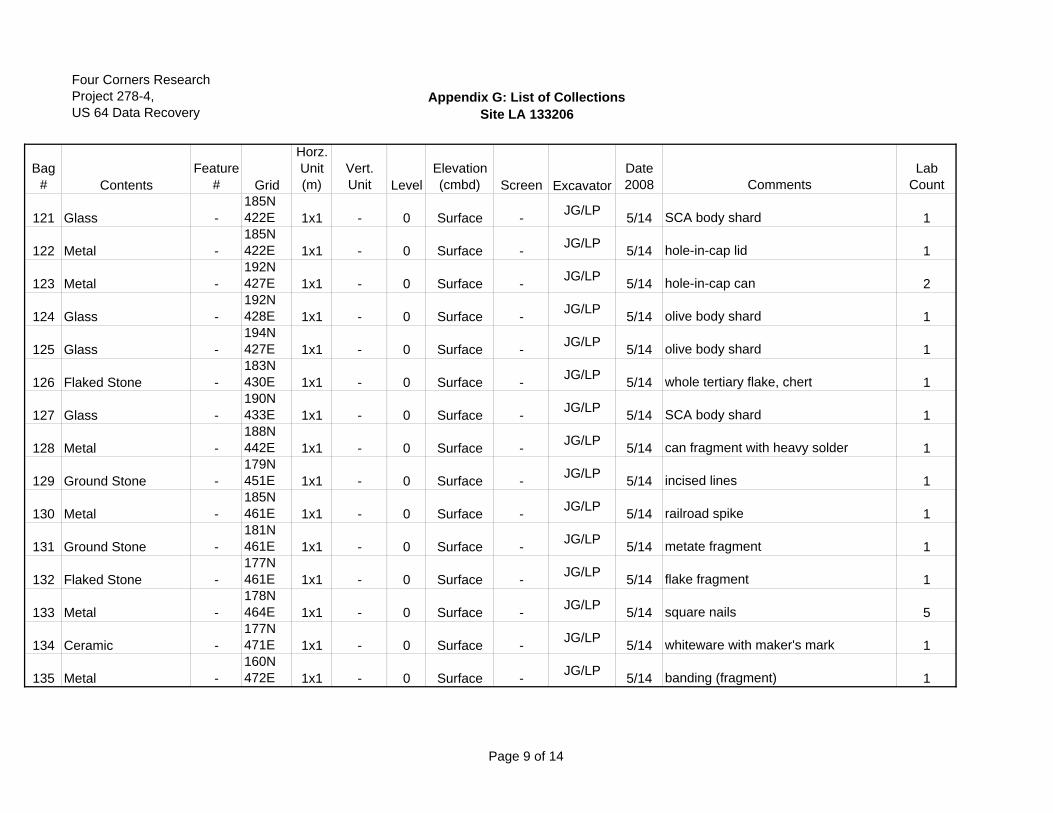
Four Corners ResearchProject 278-4,US 64 Data Recovery
Appendix G: List of CollectionsSite LA 133206
Bag# Contents
Feature# Grid
Horz.Unit(m)
Vert.Unit Level
Elevation (cmbd) Screen Excavator
Date2008 Comments
Lab Count
121 Glass -185N422E 1x1 - 0 Surface - JG/LP 5/14 SCA body shard 1
122 Metal -185N422E 1x1 - 0 Surface - JG/LP 5/14 hole-in-cap lid 1
123 Metal -192N427E 1x1 - 0 Surface - JG/LP 5/14 hole-in-cap can 2
124 Glass -192N428E 1x1 - 0 Surface - JG/LP 5/14 olive body shard 1
125 Glass -194N427E 1x1 - 0 Surface - JG/LP 5/14 olive body shard 1
126 Flaked Stone -183N430E 1x1 - 0 Surface - JG/LP 5/14 whole tertiary flake, chert 1
127 Glass -190N433E 1x1 - 0 Surface - JG/LP 5/14 SCA body shard 1
128 Metal -188N442E 1x1 - 0 Surface - JG/LP 5/14 can fragment with heavy solder 1
129 Ground Stone -179N451E 1x1 - 0 Surface - JG/LP 5/14 incised lines 1
130 Metal -185N461E 1x1 - 0 Surface - JG/LP 5/14 railroad spike 1
131 Ground Stone -181N461E 1x1 - 0 Surface - JG/LP 5/14 metate fragment 1
132 Flaked Stone -177N461E 1x1 - 0 Surface - JG/LP 5/14 flake fragment 1
133 Metal -178N464E 1x1 - 0 Surface - JG/LP 5/14 square nails 5
134 Ceramic -177N471E 1x1 - 0 Surface - JG/LP 5/14 whiteware with maker's mark 1
135 Metal -160N472E 1x1 - 0 Surface - JG/LP 5/14 banding (fragment) 1
Page 9 of 14
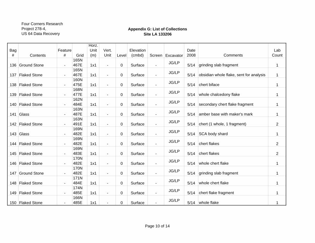
Four Corners ResearchProject 278-4,US 64 Data Recovery
Appendix G: List of CollectionsSite LA 133206
Bag# Contents
Feature# Grid
Horz.Unit(m)
Vert.Unit Level
Elevation (cmbd) Screen Excavator
Date2008 Comments
Lab Count
136 Ground Stone -165N467E 1x1 - 0 Surface - JG/LP 5/14 grinding slab fragment 1
137 Flaked Stone -165N467E 1x1 - 0 Surface - JG/LP 5/14 obsidian whole flake, sent for analysis 1
138 Flaked Stone -160N475E 1x1 - 0 Surface - JG/LP 5/14 chert biface 1
139 Flaked Stone -168N477E 1x1 - 0 Surface - JG/LP 5/14 whole chalcedony flake 1
140 Flaked Stone -162N484E 1x1 - 0 Surface - JG/LP 5/14 secondary chert flake fragment 1
141 Glass -163N487E 1x1 - 0 Surface - JG/LP 5/14 amber base with maker's mark 1
142 Flaked Stone -163N491E 1x1 - 0 Surface - JG/LP 5/14 chert (1 whole, 1 fragment) 2
143 Glass -169N482E 1x1 - 0 Surface - JG/LP 5/14 SCA body shard 1
144 Flaked Stone -169N482E 1x1 - 0 Surface - JG/LP 5/14 chert flakes 2
145 Flaked Stone -169N483E 1x1 - 0 Surface - JG/LP 5/14 chert flakes 2
146 Flaked Stone -170N482E 1x1 - 0 Surface - JG/LP 5/14 whole chert flake 1
147 Ground Stone -170N482E 1x1 - 0 Surface - JG/LP 5/14 grinding slab fragment 1
148 Flaked Stone -171N484E 1x1 - 0 Surface - JG/LP 5/14 whole chert flake 1
149 Flaked Stone -174N485E 1x1 - 0 Surface - JG/LP 5/14 chert flake fragment 1
150 Flaked Stone -166N485E 1x1 - 0 Surface - JG/LP 5/14 whole flake 1
Page 10 of 14
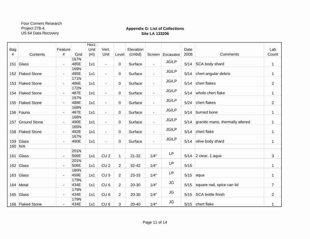
Four Corners ResearchProject 278-4,US 64 Data Recovery
Appendix G: List of CollectionsSite LA 133206
Bag# Contents
Feature# Grid
Horz.Unit(m)
Vert.Unit Level
Elevation (cmbd) Screen Excavator
Date2008 Comments
Lab Count
151 Glass -167N485E 1x1 - 0 Surface - JG/LP 5/14 SCA body shard 1
152 Flaked Stone -169N485E 1x1 - 0 Surface - JG/LP 5/14 chert angular debris 1
153 Flaked Stone -171N486E 1x1 - 0 Surface - JG/LP 5/14 chert flakes 2
154 Flaked Stone -172N487E 1x1 - 0 Surface - JG/LP 5/14 whole chert flake 1
155 Flaked Stone -167N488E 1x1 - 0 Surface - JG/LP 5/24 chert flakes 2
156 Fauna -168N487E 1x1 - 0 Surface - JG/LP 5/14 burned bone 1
157 Ground Stone -168N490E 1x1 - 0 Surface - JG/LP 5/14 granitic mano, thermally altered 1
158 Flaked Stone -165N492E 1x1 - 0 Surface - JG/LP 5/14 chert flake 1
159 Glass -167N490E 1x1 - 0 Surface - JG/LP 5/14 olive body shard 1
160 N/A
161 Glass -201N506E 1x1 CU 2 1 21-32 1/4" LP 5/14 2 clear, 1 aqua 3
162 Glass -201N506E 1x1 CU 2 2 32-42 1/4" LP 5/15 1
163 Glass -180N459E 1x1 CU 5 2 23-33 1/4" LP 5/15 aqua 1
164 Metal -179N, 434E 1x1 CU 6 2 20-30 1/4" JG 5/15 square nail, spice can lid 7
165 Glass -179N434E 1x1 CU 6 2 20-30 1/4" JG 5/15 SCA bottle finish 2
166 Flaked Stone -179N434E 1x1 CU 6 3 20-40 1/4" JG 5/15 chert flake 1
Page 11 of 14
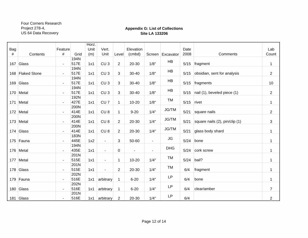
Four Corners ResearchProject 278-4,US 64 Data Recovery
Appendix G: List of CollectionsSite LA 133206
Bag# Contents
Feature# Grid
Horz.Unit(m)
Vert.Unit Level
Elevation (cmbd) Screen Excavator
Date2008 Comments
Lab Count
167 Glass -194N517E 1x1 CU 3 2 20-30 1/8" HB 5/15 fragment 1
168 Flaked Stone -194N517E 1x1 CU 3 3 30-40 1/8" HB 5/15 obsidian, sent for analysis 2
169 Glass -194N517E 1x1 CU 3 3 30-40 1/8" HB 5/15 fragments 10
170 Metal -194N517E 1x1 CU 3 3 30-40 1/8" HB 5/15 nail (1), beveled piece (1) 2
171 Metal -192N427E 1x1 CU 7 1 10-20 1/8" TM 5/15 rivet 1
172 Metal -200N414E 1x1 CU 8 1 9-20 1/4" JG/TM 5/21 square nails 2
173 Metal -200N414E 1x1 CU 8 2 20-30 1/4" JG/TM 5/21 square nails (2), pin/clip (1) 3
174 Glass -200N414E 1x1 CU 8 2 20-30 1/4" JG/TM 5/21 glass body shard 1
175 Fauna -183N445E 1x2 - 3 50-60 - JG 5/24 bone 1
176 Metal -194N435E 1x1 - 0 - - DHG 5/24 cork screw 1
177 Metal -201N515E 1x1 - 1 10-20 1/4" TM 5/24 bail? 1
178 Glass -201N515E 1x1 - 2 20-30 1/4" TM 6/4 fragment 1
179 Fauna -202N516E 1x1 arbitrary 1 6-20 1/4" LP 6/4 bone 1
180 Glass -202N516E 1x1 arbitrary 1 6-20 1/4" LP 6/4 clear/amber 7
181 Glass -201N516E 1x1 arbitrary 2 20-30 1/4" LP 6/4 2
Page 12 of 14
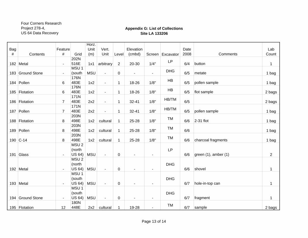
Four Corners ResearchProject 278-4,US 64 Data Recovery
Appendix G: List of CollectionsSite LA 133206
Bag# Contents
Feature# Grid
Horz.Unit(m)
Vert.Unit Level
Elevation (cmbd) Screen Excavator
Date2008 Comments
Lab Count
182 Metal -202N516E 1x1 arbitrary 2 20-30 1/4" LP 6/4 button 1
183 Ground Stone -MSU 1(south MSU - 0 - - DHG 6/5 metate 1 bag
184 Pollen 6176N483E 1x2 - 1 18-26 1/8" HB 6/5 pollen sample 1 bag
185 Flotation 6176N483E 1x2 - 1 18-26 1/8" HB 6/5 flot sample 2 bags
186 Flotation 7171N483E 2x2 - 1 32-41 1/8" HB/TM 6/5 2 bags
187 Pollen 7171N483E 2x2 - 1 32-41 1/8" HB/TM 6/5 pollen sample 1 bag
188 Flotation 8203N498E 1x2 cultural 1 25-28 1/8" TM 6/6 2-31 flot 1 bag
189 Pollen 8203N498E 1x2 cultural 1 25-28 1/8" TM 6/6 1 bag
190 C-14 8203N498E 1x2 cultural 1 25-28 1/8" TM 6/6 charcoal fragments 1 bag
191 Glass -
MSU 2(north US 64) MSU - 0 - -
LP6/6 green (1), amber (1) 2
192 Metal -
MSU 2(north US 64) MSU - 0 - -
DHG6/6 shovel 1
193 Metal -
MSU 1(south US 64) MSU - 0 - -
DHG6/7 hole-in-top can 1
194 Ground Stone -
MSU 1(south US 64) MSU - 0 - -
DHG6/7 fragment 1
195 Flotation 12180N448E 2x2 cultural 1 19-28 - TM 6/7 sample 2 bags
Page 13 of 14
Four Corners ResearchProject 278-4,US 64 Data Recovery
Appendix G: List of CollectionsSite LA 133206
Bag# Contents
Feature# Grid
Horz.Unit(m)
Vert.Unit Level
Elevation (cmbd) Screen Excavator
Date2008 Comments
Lab Count
196 C-14 12180N448E 2x2 cultural 1 19-28 1/8" TM 6/7 sample 1 packet
197 Pollen 12180N448E 2x2 cultural 1 19-28 - TM 6/7 charcoal removed and in Bag #202 1 bag
198 Metal -
MSU 2(north US 64) MSU - 0 - -
DHG6/7 possible screw driver 1
199 Wood 13183N448E 1x1 cultural 1 29-33 - HB 6/7 wood ID 1
200 Ceramic 4201N516E 1x1 arbitrary 1 20-Jun 1/4" LP 6/13 historic ceramic sherd 1
201 Charcoal 12180N448E 2x2 cultural 1 19-28 1/8" TM/HB 7/23 charcoal taken from flot Bag #195 1
202 Charcoal 12180N448E 2x2 cultural 1 19-28 1/8" TM/HB 7/23
charcoal taken from pollen sample, Bag #117 1
203 Charcoal 3176N483E 1x2 cultural 1 18-26 1/8" HB 7/23
charcoal taken from flot sample, Bag #185 1
Page 14 of 14