- 8800 llaannddssccaappee aanndd aaeesstthheettiiccss ...
49
I-80 FROM VERDI TO WEST WENDOVER & US 95 FROM WINNEMUCCA TO MCDERMITT - 80 landscape and aesthetics corridor plan - 80 landscape and aesthetics corridor plan CORRIDOR PLAN DESIGN WORKSHOP Mackay & Somps JW Zunino & Assoc. CH2MHill Jones & Jones August 5, 2005
Transcript of - 8800 llaannddssccaappee aanndd aaeesstthheettiiccss ...

I -80 FROM VERDI TO WEST
WENDOVER& US 95 FROM
WINNEMUCCA TOMCDERMITT
-- 8800 llaannddssccaappee aanndd aaeesstthheettiiccss ccoorrrriiddoorr ppllaann-- 8800 llaannddssccaappee aanndd aaeesstthheettiiccss ccoorrrriiddoorr ppllaannCORRIDOR PLAN
DESIGN WORKSHOP
Mackay & Somps
JW Zunino & Assoc.
CH2MHill
Jones & Jones
August 5, 2005


Endorsement11--8800 ccoorrrriiddoorr ppllaann
I
MESSAGE FROM THE GOVERNOR OF NEVADAKENNY C. GUINN
On June 30, 2002, the Nevada Department of Transportation adopted
as policy, "Pattern and Palette of Place: A Landscape and Aesthetics
Master Plan for the Nevada State Highway System". Now, the second
phase of planning is complete. This I-80 Landscape and Aesthetics
Corridor Plan represents a major step forward for the Landscape and
Aesthetics program created by the Master Plan. It is significant
because it involves local public agencies and citizens in the planning
process so that Nevada's highways truly represent the State and its
people. The Corridor Plan will be the primary management tool used
to guide funding allocations, promotes appropriate aesthetic design,
and provides for the incorporation of highway elements that unique-
ly express Nevada's landscape, communities, and cities, as well as its
people. The State considers this Corridor Plan to be a major accom-
plishment for the future of Nevada highways.
MESSAGE FROM THE DIRECTORNEVADA DEPARTMENT OF TRANSPORTATION
JEFF FONTAINE, P.E.
It is NDOT's responsibility to ensure that landscaping and aesthetics
are an important consideration in building and retrofitting our high-
way system. This Landscape and Aesthetics Corridor Plan for I-80 in
Northern Nevada helps realize our vision for the future appearance of
our highways. The plan will provide the guidance for our own design
teams as well as help Nevada's citizens play an important role in the
context-sensitive solutions for today's transportation needs.
Together, we will ensure our highways reflect Nevada's distinctive
heritage, landscape, and culture.

II
Endorsement11--8800 ccoorrrriiddoorr ppllaann
ENDORSEMENT
This Corridor Plan has been reviewed by the following groups and agencies:
Battle Mountain Band
Churchill County
City of Elko
City of Carlin
City of Fernley
City of Lovelock
City of Reno
City of Sparks
City of Wells
City of West Wendover
City of Winnemucca
Da Ka Doiyabe Resource Conservation and Development
Economic Development Authority of Western Nevada
Elko Chamber of Commerce
Elko County
Eureka County
Fernley Chamber of Commerce
Great Basin Community College
Humboldt County
Humboldt River Ranch Association
Keep Truckee Meadows Beautiful
Lander County
Lovelock Paiute Tribe
Lyon County
McDermitt, Desert Inn
National Park Service
Nevada Department of Transportation, District 2
Nevada Department of Transportation, District 3
Nevada Division of Forestry
Nevada Division of State Parks
Nevada Land Conservancy
Nevada Statewide Tree Council
Newmont Mining Corporation, Western Nevada Operations
Northern Nevada Development Authority
Pershing County
Pyramid Lake Paiute Tribe
Regional Transportation Commission of Washoe County
Reno-Sparks Chamber of Commerce
Reno-Sparks Convention & Visitors Authority
Reno-Sparks Indian Colony Planning Department
Scenic Nevada
Sierra Club - Toiyabe Chapter
South Fork Band Te-Moak Tribe
Sparks Chamber of Commerce
Storey County
Tahoe-Pyramid Bikeway
Te-Moak Tribe of Western Shoshone Indians, and Elko Band
Trails West
Truckee Meadows Community College
Truckee Meadows Regional Planning
Truckee Meadows Tomorrow
University of Nevada Cooperative Extension
U.S. Army Corp of Engineers
U.S. Bureau of Land Management
U.S. Department of Transportation - Federal Highway Administration
U.S. Fish & Wildlife Service
Washoe County
Wells Band Te-Moak Tribe
Western Trails Research Association
Winnemucca Convention and Visitors Authority
Winnemucca Indian Colony

TECHNICAL REVIEW COMMITTEEAlan GoodaleBecky StockBill BowersBill DeistBill YoungBlaine BranscombBrad GoetschBryant SmithCasey KelleyCharles GreenlawChere JigourChris MelvilleChristine FeyChuck PopeDave LingeDavid HolleckerDelmo AndreozziDennis CrooksDennis GhiglieriDonald NaquinDonna HillDonna KristaponisDora WrenEleanor Lockwood
Ellis AntunezFrank FlavinGerry EmmGeorgia MorganGerald MillerGreg NovakGregory HolleyHannah VisserHarry YorkHelen HankinsHugh StevensIllyssa FogelJeff WhiteJim AagardJoe CrimJohn RussumJoyce SheenKevin LeeKim PetersenKitty NashKristi DegayLen StevensLora RichardsLorrie Chase
Marchon MillerMarilou WallingMary Ann McAuliffeMarshall FeyMarvin OrrMelissa DeckerMichael MurphyMike AllisonNeil McQuearyOtis TiptonPeter WysockiRichard GebhartRichard NelsonRobert StokesRobert WilliamsRobin PowellRonnie WoodsRoger SuttonRon DameleRon WeisingerRoss SoderstromScott NebeskySteve WeaverSteve West
ACKNOWLEDGEMENTS
Acknowledgements11--8800 ccoorrrriiddoorr ppllaann
IIIiii
Tom FranswayTony DietzTony George
Tracy Larkin-ThomasonTrevor LloydVivian Lava
William Kohbarger
Jim BellRandy BellardKristine BunnellDaryl CapurroBill CadwalladerKent CooperDaryl CrawfordCarl DahlenJoe DamianiJerry Duke
Keyth DurhamJon EkstrandJohn FlansbergDavid FraserLarry FriedmanDebra GoodwinMella HarmonSig JaunarajsCharlie KajkowskiNeil Krutz
Jim LawrenceBruce MackeyMarty ManningRod SaviniRon SkunesGary StockoffSteve WeaverJenny Welsh
STATE TRANSPORTATION BOARDChairman Kenny C. Guinn GovernorKathy Augustine ControllerCaesar Caviglia MemberTom Gust MemberLorraine Hunt Lt. GovernorBrian Sandoval Attorney GeneralJim Thornton Member
NEVADA DEPARTMENT OF TRANSPORTATIONJames R. Souba, P.E. - Former Assistant Chief of Roadway Design EngineerRand Pollard, P.E. - Assistant Chief Roadway Design Engineer Ron Blakemore - Supervising Landscape ArchitectLucy Joyce-Mendive - Senior Landscape ArchitectSusan Luescher - Assistant Landscape Architect
UNIVERSITY OF NEVADA, LAS VEGAS LANDSCAPE ARCHITECTURE ANDPLANNING RESEARCH OFFICEMark Elison Hoversten - Professor, FASLA, AICPSusan Jones - Research Associate, ASLAElizabeth Scott - Research Associate, ASLABrian Pugh - Research Assistant, ASLA
CONSULTANT TEAMDESIGN WORKSHOP
Richard W. Shaw - Principal, FASLASteve Noll - Principal, ASLAStephanie Grigsby - Associate, ASLAKristofer Johnson - Landscape PlannerSara Muir-Owen - PlannerLaura Miller - Landscape DesignerEric Roverud - Landscape DesignerLisa McGuire - Graphic DesignerNino Pero - Website DesignerKelan Smith - Environmental GraphicsDori Johnson - Project Assistant
MACKAY AND SOMPS (PLACES, INC.)Barbara Santner - Landscape Architect and Planner, ASLA, AICPTom Guyer - ASLALouise Keheimer - Landscape Architect
JW ZUNINO
Jack Zunino - Principal, FASLACecilia Schafler - Landscape Architect, ASLAGeoffrey Schafler - Landscape Coordinator, ASLA
CH2MHILL
Cindy Potter - P.E. Civil Engineer, Principal Dean Mottram - P.E. Civil EngineerDan Andersen - Public Facilitator
JONES AND JONES
James Sipes - Landscape Architect and Digital Database Development, ASLACorey Parker - Associate
STTAC (Statewide Transportation Technical Advisory Committee)

IV

Summary11--8800 ccoorrrriiddoorr ppllaann
Vv
How to Use the Corridor Plan for aSegment of I-80:
• Refer to the section beginning on page
3.1 to determine softscape and hard-
scape type and treatment.
• Refer to the section beginning on page
4.1 to determine the Landscape Design
Segment and design theme. .
• Refer to the section beginning on page
4.9 for design objectives and intended
future context.
• Refer to pages 4.13, 4.21, 4.29, and 4.47
for design interpretation.
• Refer to the section beginning on page
5.1 for specific design guidelines.
• Refer to the section beginning on page
6.1 for the description of funding and
costs.
• Refer to the section beginning on page
7.1 for project priorities.
This Corridor Plan is a management tool that will direct decisions made on Nevada’s Interstate Highway system with the goal of consider-ing landscape and aesthetics as an integrated part of all design undertaken by NDOT and the community partners within the state.
I-80 CORRIDOR PLAN SUMMARYAND USER’S GUIDE
This plan illustrates a detailed visionfor the landscape and aesthetics of theI-80 corridor. This vision synthesizeshistoric, current, and future conditionsinto a comprehensive guide toimprove the visual appearance of the I-80 Urban and I-80 Rural highway corri-dors from the California stateline atVerdi to the Utah border at WestWendover and US 95 fromWinnemucca to McDermitt.
The first chapter of this report providesan introduction to the NDOT
Landscape and Aestheticsprogram, the public partici-pation process that hasinfluenced the program,
and the mechanism
by which the design of the corridor willbe managed. The second chapter setsthe foundation for many of the designand project decisions discussed later inthe report. In this chapter, informationregarding demographics and growth,water availability, land ownership, andnatural resources is discussed. Adetailed analysis of the terrain sur-rounding the I-80 corridor, includingviewsheds to significant natural fea-tures and environmental features, isalso presented. This information isthen synthesized in a series ofOpportunities and Constraints mapsthat specifically identify project oppor-tunities along four distinct segmentsof the corridor. These chapters shouldbe read carefully so design decisionswill be made with a solid analyticalbasis rooted in the physical and histor-ical nature of the area.
The third chapter, Elements ofLandscape and Aesthetics, is critical tounderstanding the types of enhance-ments and traveler amenities thatwill be provided through the NDOTHighway Landscape and Aestheticsprogram. At the beginning of the
chapter is a description of softscapeand hardscape types. These representincreasing levels of visual enhance-ment, amenity, cost, and maintenance,and have been prescribed across theentire I-80 corridor. Additional itemsincluded in the Elements of Landscapeand Aesthetics are a roadside signageprogram, varying degrees of enhancedroad services, a native wildflower pro-gram, and an effort to minimize thevisual impacts of outdoor advertisingand billboards.
Detailed analysis and further under-standing of the I-80 corridor resultedin the creation of four distinct, yetconsistent, Landscape DesignSegments: Sierra Nevada Passage,Sierra Nevada Great/Basin Crossroads,Truckee River Passage, and Highway ofthe West. These segments are exam-ined individually in the fourthchapter of this report. Adescription of the themeand design objectives ofeach segment is providedto give the reader asense of the design aes-thetic that is appropri-
ate and desired within the segment.Maps and sections of the individualLandscape Design Segments providefurther detail regarding the location ofspecific projects and where the varyinglevels of softscape types, structures,hardscape types, and their treatmentsare to be achieved.
Design guidelines are included in thefifth chapter to articulate qualitativedesign for all aspects of the corridor.These apply at all levels of engineering,facility planning, and design. The finalchapters describe funding and projectpriorities for each segment of the I-80corridor.

VI
Table of Contents11--8800 ccoorrrriiddoorr ppllaann
TABLE OF CONTENTSPAGE NUMBER
1. INTRODUCTION . . . . . . . . . . . . . . . . . . . . . . . . . . . . . . . . . . . . . . . . . . . . . . . . . . . . . . . . . . . . . . . . . . . . . . . . . . . . . . . . . . . . . . . . . . . . . . . . . . . . . . . . . . . . . . . . . . . . . . . . . . . . . . . . . . . . . . . . . . . . . . . . . . . . . . . . . . . 1.0NDOT HIGHWAY LANDSCAPE AND AESTHETICS - THE VISION . . . . . . . . . . . . . . . . . . . . . . . . . . . . . . . . . . . . . . . . . . . . . . . . . . . . . . . . . . . . . . . . . . . . . . . . . . . . . . . . . . . . . . . . . . . . . . . . . . . . . . . . . . . . . . . . . . . . 1.1PURPOSE OF THE CORRIDOR PLAN . . . . . . . . . . . . . . . . . . . . . . . . . . . . . . . . . . . . . . . . . . . . . . . . . . . . . . . . . . . . . . . . . . . . . . . . . . . . . . . . . . . . . . . . . . . . . . . . . . . . . . . . . . . . . . . . . . . . . . . . . . . . . . . . . . . . . . . . . . . . 1.1PUBLIC PARTICIPATION PROCESS . . . . . . . . . . . . . . . . . . . . . . . . . . . . . . . . . . . . . . . . . . . . . . . . . . . . . . . . . . . . . . . . . . . . . . . . . . . . . . . . . . . . . . . . . . . . . . . . . . . . . . . . . . . . . . . . . . . . . . . . . . . . . . . . . . . . . . . . . . . . . . 1.2CORRIDOR DESIGN MANAGEMENT . . . . . . . . . . . . . . . . . . . . . . . . . . . . . . . . . . . . . . . . . . . . . . . . . . . . . . . . . . . . . . . . . . . . . . . . . . . . . . . . . . . . . . . . . . . . . . . . . . . . . . . . . . . . . . . . . . . . . . . . . . . . . . . . . . . . . . . . . . . . 1.3OVERVIEW OF CORRIDOR PLAN . . . . . . . . . . . . . . . . . . . . . . . . . . . . . . . . . . . . . . . . . . . . . . . . . . . . . . . . . . . . . . . . . . . . . . . . . . . . . . . . . . . . . . . . . . . . . . . . . . . . . . . . . . . . . . . . . . . . . . . . . . . . . . . . . . . . . . . . . . . . . . . 1.4
2. BACKGROUND INFORMATION . . . . . . . . . . . . . . . . . . . . . . . . . . . . . . . . . . . . . . . . . . . . . . . . . . . . . . . . . . . . . . . . . . . . . . . . . . . . . . . . . . . . . . . . . . . . . . . . . . . . . . . . . . . . . . . . . . . . . . . . . . . . . . . . . . . . . . . . . . . . . . . 2.0PRESENT & FUTURE COMMUNITY GROWTH . . . . . . . . . . . . . . . . . . . . . . . . . . . . . . . . . . . . . . . . . . . . . . . . . . . . . . . . . . . . . . . . . . . . . . . . . . . . . . . . . . . . . . . . . . . . . . . . . . . . . . . . . . . . . . . . . . . . . . . . . . . . . . . . . . . . 2.1ANTICIPATED URBAN CHANGES . . . . . . . . . . . . . . . . . . . . . . . . . . . . . . . . . . . . . . . . . . . . . . . . . . . . . . . . . . . . . . . . . . . . . . . . . . . . . . . . . . . . . . . . . . . . . . . . . . . . . . . . . . . . . . . . . . . . . . . . . . . . . . . . . . . . . . . . . . . . . . . 2.1LAND OWNERSHIP . . . . . . . . . . . . . . . . . . . . . . . . . . . . . . . . . . . . . . . . . . . . . . . . . . . . . . . . . . . . . . . . . . . . . . . . . . . . . . . . . . . . . . . . . . . . . . . . . . . . . . . . . . . . . . . . . . . . . . . . . . . . . . . . . . . . . . . . . . . . . . . . . . . . . . . . . . . 2.1WATER RESOURCE AVAILABILITY . . . . . . . . . . . . . . . . . . . . . . . . . . . . . . . . . . . . . . . . . . . . . . . . . . . . . . . . . . . . . . . . . . . . . . . . . . . . . . . . . . . . . . . . . . . . . . . . . . . . . . . . . . . . . . . . . . . . . . . . . . . . . . . . . . . . . . . . . . . . . . 2.2COMMUNITY SETTLEMENT PATTERNS . . . . . . . . . . . . . . . . . . . . . . . . . . . . . . . . . . . . . . . . . . . . . . . . . . . . . . . . . . . . . . . . . . . . . . . . . . . . . . . . . . . . . . . . . . . . . . . . . . . . . . . . . . . . . . . . . . . . . . . . . . . . . . . . . . . . . . . . . 2.2TRAVEL AND TOURISM PATTERNS . . . . . . . . . . . . . . . . . . . . . . . . . . . . . . . . . . . . . . . . . . . . . . . . . . . . . . . . . . . . . . . . . . . . . . . . . . . . . . . . . . . . . . . . . . . . . . . . . . . . . . . . . . . . . . . . . . . . . . . . . . . . . . . . . . . . . . . . . . . . . 2.2NATURAL RESOURCES . . . . . . . . . . . . . . . . . . . . . . . . . . . . . . . . . . . . . . . . . . . . . . . . . . . . . . . . . . . . . . . . . . . . . . . . . . . . . . . . . . . . . . . . . . . . . . . . . . . . . . . . . . . . . . . . . . . . . . . . . . . . . . . . . . . . . . . . . . . . . . . . . . . . . . . . 2.3VIEWSHEDS AND DISTANCE ZONES . . . . . . . . . . . . . . . . . . . . . . . . . . . . . . . . . . . . . . . . . . . . . . . . . . . . . . . . . . . . . . . . . . . . . . . . . . . . . . . . . . . . . . . . . . . . . . . . . . . . . . . . . . . . . . . . . . . . . . . . . . . . . . . . . . . . . . . . . . . . 2.4VISUAL ANALYSIS . . . . . . . . . . . . . . . . . . . . . . . . . . . . . . . . . . . . . . . . . . . . . . . . . . . . . . . . . . . . . . . . . . . . . . . . . . . . . . . . . . . . . . . . . . . . . . . . . . . . . . . . . . . . . . . . . . . . . . . . . . . . . . . . . . . . . . . . . . . . . . . . . . . . . . . . . . . . 2.5ENVIRONMENTAL ANALYSIS . . . . . . . . . . . . . . . . . . . . . . . . . . . . . . . . . . . . . . . . . . . . . . . . . . . . . . . . . . . . . . . . . . . . . . . . . . . . . . . . . . . . . . . . . . . . . . . . . . . . . . . . . . . . . . . . . . . . . . . . . . . . . . . . . . . . . . . . . . . . . . . . . . 2.5
3. ELEMENTS OF LANDSCAPE AND AESTHETICS . . . . . . . . . . . . . . . . . . . . . . . . . . . . . . . . . . . . . . . . . . . . . . . . . . . . . . . . . . . . . . . . . . . . . . . . . . . . . . . . . . . . . . . . . . . . . . . . . . . . . . . . . . . . . . . . . . . . . . . . . . . . . . . . . 3.0ELEMENTS OF LANDSCAPE AND AESTHETICS . . . . . . . . . . . . . . . . . . . . . . . . . . . . . . . . . . . . . . . . . . . . . . . . . . . . . . . . . . . . . . . . . . . . . . . . . . . . . . . . . . . . . . . . . . . . . . . . . . . . . . . . . . . . . . . . . . . . . . . . . . . . . . . . . . . 3.1SOFTSCAPE TYPES AND TREATMENTS . . . . . . . . . . . . . . . . . . . . . . . . . . . . . . . . . . . . . . . . . . . . . . . . . . . . . . . . . . . . . . . . . . . . . . . . . . . . . . . . . . . . . . . . . . . . . . . . . . . . . . . . . . . . . . . . . . . . . . . . . . . . . . . . . . . . . . . . . . 3.2STRUCTURES AND HARDSCAPE TYPES AND TREATMENTS . . . . . . . . . . . . . . . . . . . . . . . . . . . . . . . . . . . . . . . . . . . . . . . . . . . . . . . . . . . . . . . . . . . . . . . . . . . . . . . . . . . . . . . . . . . . . . . . . . . . . . . . . . . . . . . . . . . . . . . 3.6NEVADA PLACE NAME SIGN PROGRAM . . . . . . . . . . . . . . . . . . . . . . . . . . . . . . . . . . . . . . . . . . . . . . . . . . . . . . . . . . . . . . . . . . . . . . . . . . . . . . . . . . . . . . . . . . . . . . . . . . . . . . . . . . . . . . . . . . . . . . . . . . . . . . . . . . . . . . . . 3.8ROAD SERVICES PROGRAM . . . . . . . . . . . . . . . . . . . . . . . . . . . . . . . . . . . . . . . . . . . . . . . . . . . . . . . . . . . . . . . . . . . . . . . . . . . . . . . . . . . . . . . . . . . . . . . . . . . . . . . . . . . . . . . . . . . . . . . . . . . . . . . . . . . . . . . . . . . . . . . . . . . . 3.10NATIVE WILDFLOWER PROGRAM . . . . . . . . . . . . . . . . . . . . . . . . . . . . . . . . . . . . . . . . . . . . . . . . . . . . . . . . . . . . . . . . . . . . . . . . . . . . . . . . . . . . . . . . . . . . . . . . . . . . . . . . . . . . . . . . . . . . . . . . . . . . . . . . . . . . . . . . . . . . . . 3.12INVASIVE AND NOXIOUS WEED CONTROL . . . . . . . . . . . . . . . . . . . . . . . . . . . . . . . . . . . . . . . . . . . . . . . . . . . . . . . . . . . . . . . . . . . . . . . . . . . . . . . . . . . . . . . . . . . . . . . . . . . . . . . . . . . . . . . . . . . . . . . . . . . . . . . . . . . . . 3.12OUTDOOR ADVERTISING . . . . . . . . . . . . . . . . . . . . . . . . . . . . . . . . . . . . . . . . . . . . . . . . . . . . . . . . . . . . . . . . . . . . . . . . . . . . . . . . . . . . . . . . . . . . . . . . . . . . . . . . . . . . . . . . . . . . . . . . . . . . . . . . . . . . . . . . . . . . . . . . . . . . . 3.13SCENIC HIGHWAY DESIGNATION . . . . . . . . . . . . . . . . . . . . . . . . . . . . . . . . . . . . . . . . . . . . . . . . . . . . . . . . . . . . . . . . . . . . . . . . . . . . . . . . . . . . . . . . . . . . . . . . . . . . . . . . . . . . . . . . . . . . . . . . . . . . . . . . . . . . . . . . . . . . . . 3.14ANTI-LITTERING CAMPAIGN AND SIGNAGE . . . . . . . . . . . . . . . . . . . . . . . . . . . . . . . . . . . . . . . . . . . . . . . . . . . . . . . . . . . . . . . . . . . . . . . . . . . . . . . . . . . . . . . . . . . . . . . . . . . . . . . . . . . . . . . . . . . . . . . . . . . . . . . . . . . . . 3.15
4. LANDSCAPE DESIGN SEGMENTS . . . . . . . . . . . . . . . . . . . . . . . . . . . . . . . . . . . . . . . . . . . . . . . . . . . . . . . . . . . . . . . . . . . . . . . . . . . . . . . . . . . . . . . . . . . . . . . . . . . . . . . . . . . . . . . . . . . . . . . . . . . . . . . . . . . . . . . . . . . . . 4.0LANDSCAPE DESIGN SEGMENTS . . . . . . . . . . . . . . . . . . . . . . . . . . . . . . . . . . . . . . . . . . . . . . . . . . . . . . . . . . . . . . . . . . . . . . . . . . . . . . . . . . . . . . . . . . . . . . . . . . . . . . . . . . . . . . . . . . . . . . . . . . . . . . . . . . . . . . . . . . . . . . . 4.1OPPORTUNITIES AND CONSTRAINTS . . . . . . . . . . . . . . . . . . . . . . . . . . . . . . . . . . . . . . . . . . . . . . . . . . . . . . . . . . . . . . . . . . . . . . . . . . . . . . . . . . . . . . . . . . . . . . . . . . . . . . . . . . . . . . . . . . . . . . . . . . . . . . . . . . . . . . . . . . . 4.8SEGMENT 1 - SIERRA NEVADA PASSAGE . . . . . . . . . . . . . . . . . . . . . . . . . . . . . . . . . . . . . . . . . . . . . . . . . . . . . . . . . . . . . . . . . . . . . . . . . . . . . . . . . . . . . . . . . . . . . . . . . . . . . . . . . . . . . . . . . . . . . . . . . . . . . . . . . . . . . . . . 4.9SEGMENT 2 - SIERRA NEVADA/GREAT BASIN CROSSROADS . . . . . . . . . . . . . . . . . . . . . . . . . . . . . . . . . . . . . . . . . . . . . . . . . . . . . . . . . . . . . . . . . . . . . . . . . . . . . . . . . . . . . . . . . . . . . . . . . . . . . . . . . . . . . . . . . . . . . . 4.17SEGMENT 3 - TRUCKEE RIVER PASSAGE . . . . . . . . . . . . . . . . . . . . . . . . . . . . . . . . . . . . . . . . . . . . . . . . . . . . . . . . . . . . . . . . . . . . . . . . . . . . . . . . . . . . . . . . . . . . . . . . . . . . . . . . . . . . . . . . . . . . . . . . . . . . . . . . . . . . . . . . . 4.25SEGMENT 4 - HIGHWAY OF THE WEST . . . . . . . . . . . . . . . . . . . . . . . . . . . . . . . . . . . . . . . . . . . . . . . . . . . . . . . . . . . . . . . . . . . . . . . . . . . . . . . . . . . . . . . . . . . . . . . . . . . . . . . . . . . . . . . . . . . . . . . . . . . . . . . . . . . . . . . . . 4.33
5. DESIGN GUIDELINES . . . . . . . . . . . . . . . . . . . . . . . . . . . . . . . . . . . . . . . . . . . . . . . . . . . . . . . . . . . . . . . . . . . . . . . . . . . . . . . . . . . . . . . . . . . . . . . . . . . . . . . . . . . . . . . . . . . . . . . . . . . . . . . . . . . . . . . . . . . . . . . . . . . . . . . . 5.0
6. GUIDELINES AND COST ANALYSIS . . . . . . . . . . . . . . . . . . . . . . . . . . . . . . . . . . . . . . . . . . . . . . . . . . . . . . . . . . . . . . . . . . . . . . . . . . . . . . . . . . . . . . . . . . . . . . . . . . . . . . . . . . . . . . . . . . . . . . . . . . . . . . . . . . . . . . . . . . . 6.0OVERVIEW . . . . . . . . . . . . . . . . . . . . . . . . . . . . . . . . . . . . . . . . . . . . . . . . . . . . . . . . . . . . . . . . . . . . . . . . . . . . . . . . . . . . . . . . . . . . . . . . . . . . . . . . . . . . . . . . . . . . . . . . . . . . . . . . . . . . . . . . . . . . . . . . . . . . . . . . . . . . . . . . . . . 6.1PROCESS . . . . . . . . . . . . . . . . . . . . . . . . . . . . . . . . . . . . . . . . . . . . . . . . . . . . . . . . . . . . . . . . . . . . . . . . . . . . . . . . . . . . . . . . . . . . . . . . . . . . . . . . . . . . . . . . . . . . . . . . . . . . . . . . . . . . . . . . . . . . . . . . . . . . . . . . . . . . . . . . . . . . 6.1APPLICATION OF DESIGN GUIDELINES . . . . . . . . . . . . . . . . . . . . . . . . . . . . . . . . . . . . . . . . . . . . . . . . . . . . . . . . . . . . . . . . . . . . . . . . . . . . . . . . . . . . . . . . . . . . . . . . . . . . . . . . . . . . . . . . . . . . . . . . . . . . . . . . . . . . . . . . . . 6.1COST ANALYSIS . . . . . . . . . . . . . . . . . . . . . . . . . . . . . . . . . . . . . . . . . . . . . . . . . . . . . . . . . . . . . . . . . . . . . . . . . . . . . . . . . . . . . . . . . . . . . . . . . . . . . . . . . . . . . . . . . . . . . . . . . . . . . . . . . . . . . . . . . . . . . . . . . . . . . . . . . . . . . . 6.3MAINTENANCE COSTS . . . . . . . . . . . . . . . . . . . . . . . . . . . . . . . . . . . . . . . . . . . . . . . . . . . . . . . . . . . . . . . . . . . . . . . . . . . . . . . . . . . . . . . . . . . . . . . . . . . . . . . . . . . . . . . . . . . . . . . . . . . . . . . . . . . . . . . . . . . . . . . . . . . . . . . . 6.7PROJECT FUNDING . . . . . . . . . . . . . . . . . . . . . . . . . . . . . . . . . . . . . . . . . . . . . . . . . . . . . . . . . . . . . . . . . . . . . . . . . . . . . . . . . . . . . . . . . . . . . . . . . . . . . . . . . . . . . . . . . . . . . . . . . . . . . . . . . . . . . . . . . . . . . . . . . . . . . . . . . . . 6.8
7. PRIORITY PROJECTS . . . . . . . . . . . . . . . . . . . . . . . . . . . . . . . . . . . . . . . . . . . . . . . . . . . . . . . . . . . . . . . . . . . . . . . . . . . . . . . . . . . . . . . . . . . . . . . . . . . . . . . . . . . . . . . . . . . . . . . . . . . . . . . . . . . . . . . . . . . . . . . . . . . . . . . . 7.0
8. CONCLUSION . . . . . . . . . . . . . . . . . . . . . . . . . . . . . . . . . . . . . . . . . . . . . . . . . . . . . . . . . . . . . . . . . . . . . . . . . . . . . . . . . . . . . . . . . . . . . . . . . . . . . . . . . . . . . . . . . . . . . . . . . . . . . . . . . . . . . . . . . . . . . . . . . . . . . . . . . . . . . . 8.0
A. TECHNICAL APPENDIX . . . . . . . . . . . . . . . . . . . . . . . . . . . . . . . . . . . . . . . . . . . . . . . . . . . . . . . . . . . . . . . . . . . . . . . . . . . . . . . . . . . . . . . . . . . . . . . . . . . . . . . . . . . . . . . . . . . . . . . . . . . . . . . . . . . . . . . . . . . . . . . . . . . . . . A.0
B. BIBLIOGRAPHY . . . . . . . . . . . . . . . . . . . . . . . . . . . . . . . . . . . . . . . . . . . . . . . . . . . . . . . . . . . . . . . . . . . . . . . . . . . . . . . . . . . . . . . . . . . . . . . . . . . . . . . . . . . . . . . . . . . . . . . . . . . . . . . . . . . . . . . . . . . . . . . . . . . . . . . . . . . . B.0

Table of Contents11--8800 ccoorrrriiddoorr ppllaann
VIIvii
MAPS AND ILLUSTRATIONSPAGE NUMBER
BACKGROUND INFORMATION . . . . . . . . . . . . . . . . . . . . . . . . . . . . . . . . . . . . . . . . . . . . . . . . . . . . . . . . . . . . . . . . . . . . . . . . . . . . . . . . . . . . . . . . . . . . . . . . . . . . . . . . . . . . . . . . . . . . . . . . . . . . . . . . . . . . . . . . . . . . . . . . . 2.0
MAP A: VIEWSHED AND DISTANCE ZONES: I-80 VERDI TO FERNLEY . . . . . . . . . . . . . . . . . . . . . . . . . . . . . . . . . . . . . . . . . . . . . . . . . . . . . . . . . . . . . . . . . . . . . . . . . . . . . . . . . . . . . . . . . . . . . . . . . . . . . . . . . . . . . . . 2.6
MAP B: VIEWSHED AND DISTANCE ZONES: I-80 FERNLEY TO RYE PATCH . . . . . . . . . . . . . . . . . . . . . . . . . . . . . . . . . . . . . . . . . . . . . . . . . . . . . . . . . . . . . . . . . . . . . . . . . . . . . . . . . . . . . . . . . . . . . . . . . . . . . . . . . . 2.7
MAP C: VIEWSHED AND DISTANCE ZONES: I-80 RYE PATCH TO TYROL . . . . . . . . . . . . . . . . . . . . . . . . . . . . . . . . . . . . . . . . . . . . . . . . . . . . . . . . . . . . . . . . . . . . . . . . . . . . . . . . . . . . . . . . . . . . . . . . . . . . . . . . . . . . 2.8
MAP D: VIEWSHED AND DISTANCE ZONES: I-80 TYROL TO WEST WENDOVER . . . . . . . . . . . . . . . . . . . . . . . . . . . . . . . . . . . . . . . . . . . . . . . . . . . . . . . . . . . . . . . . . . . . . . . . . . . . . . . . . . . . . . . . . . . . . . . . . . . . . 2.9
MAP E: VIEWSHED AND DISTANCE ZONES: US 95 WINNEMUCCA TO MCDERMITT . . . . . . . . . . . . . . . . . . . . . . . . . . . . . . . . . . . . . . . . . . . . . . . . . . . . . . . . . . . . . . . . . . . . . . . . . . . . . . . . . . . . . . . . . . . . . . . . . 2.10
MAP F: VISUAL ANALYSIS: I-80 VERDI TO FERNLEY . . . . . . . . . . . . . . . . . . . . . . . . . . . . . . . . . . . . . . . . . . . . . . . . . . . . . . . . . . . . . . . . . . . . . . . . . . . . . . . . . . . . . . . . . . . . . . . . . . . . . . . . . . . . . . . . . . . . . . . . . . . . . . 2.11
MAP G: VISUAL ANALYSIS: I-80 FERNLEY TO RYE PATCH . . . . . . . . . . . . . . . . . . . . . . . . . . . . . . . . . . . . . . . . . . . . . . . . . . . . . . . . . . . . . . . . . . . . . . . . . . . . . . . . . . . . . . . . . . . . . . . . . . . . . . . . . . . . . . . . . . . . . . . . . 2.12
MAP H: VISUAL ANALYSIS: I-80 RYE PATCH TO TYROL . . . . . . . . . . . . . . . . . . . . . . . . . . . . . . . . . . . . . . . . . . . . . . . . . . . . . . . . . . . . . . . . . . . . . . . . . . . . . . . . . . . . . . . . . . . . . . . . . . . . . . . . . . . . . . . . . . . . . . . . . . . 2.13
MAP I: VISUAL ANALYSIS: I-80 TYROL TO WEST WENDOVER . . . . . . . . . . . . . . . . . . . . . . . . . . . . . . . . . . . . . . . . . . . . . . . . . . . . . . . . . . . . . . . . . . . . . . . . . . . . . . . . . . . . . . . . . . . . . . . . . . . . . . . . . . . . . . . . . . . . . 2.14
MAP J: VISUAL ANALYSIS: US 95 WINNEMUCCA TO MCDERMITT . . . . . . . . . . . . . . . . . . . . . . . . . . . . . . . . . . . . . . . . . . . . . . . . . . . . . . . . . . . . . . . . . . . . . . . . . . . . . . . . . . . . . . . . . . . . . . . . . . . . . . . . . . . . . . . . . 2.15
MAP K: ENVIRONMENTAL ANALYSIS: I-80 VERDI TO FERNLEY . . . . . . . . . . . . . . . . . . . . . . . . . . . . . . . . . . . . . . . . . . . . . . . . . . . . . . . . . . . . . . . . . . . . . . . . . . . . . . . . . . . . . . . . . . . . . . . . . . . . . . . . . . . . . . . . . . . . 2.16
MAP L: ENVIRONMENTAL ANALYSIS: I-80 FERNLEY TO RYE PATCH . . . . . . . . . . . . . . . . . . . . . . . . . . . . . . . . . . . . . . . . . . . . . . . . . . . . . . . . . . . . . . . . . . . . . . . . . . . . . . . . . . . . . . . . . . . . . . . . . . . . . . . . . . . . . . . . 2.17
MAP M: ENVIRONMENTAL ANALYSIS: I-80 RYE PATCH TO TYROL . . . . . . . . . . . . . . . . . . . . . . . . . . . . . . . . . . . . . . . . . . . . . . . . . . . . . . . . . . . . . . . . . . . . . . . . . . . . . . . . . . . . . . . . . . . . . . . . . . . . . . . . . . . . . . . . . 2.18
MAP N: ENVIRONMENTAL ANALYSIS: I-80 TYROL TO WEST WENDOVER . . . . . . . . . . . . . . . . . . . . . . . . . . . . . . . . . . . . . . . . . . . . . . . . . . . . . . . . . . . . . . . . . . . . . . . . . . . . . . . . . . . . . . . . . . . . . . . . . . . . . . . . . . 2.19
MAP O: ENVIRONMENTAL ANALYSIS: US 95 WINNEMUCCA TO MCDERMITT . . . . . . . . . . . . . . . . . . . . . . . . . . . . . . . . . . . . . . . . . . . . . . . . . . . . . . . . . . . . . . . . . . . . . . . . . . . . . . . . . . . . . . . . . . . . . . . . . . . . . . 2.20
LANDSCAPE DESIGN SEGMENTS . . . . . . . . . . . . . . . . . . . . . . . . . . . . . . . . . . . . . . . . . . . . . . . . . . . . . . . . . . . . . . . . . . . . . . . . . . . . . . . . . . . . . . . . . . . . . . . . . . . . . . . . . . . . . . . . . . . . . . . . . . . . . . . . . . . . . . . . . . . . . . . 4.0
MAP P: LANDSCAPE DESIGN SEGMENTS: I-80 VERDI TO FERNLEY . . . . . . . . . . . . . . . . . . . . . . . . . . . . . . . . . . . . . . . . . . . . . . . . . . . . . . . . . . . . . . . . . . . . . . . . . . . . . . . . . . . . . . . . . . . . . . . . . . . . . . . . . . . . . . . . . 4.3
MAP Q: LANDSCAPE DESIGN SEGMENTS: I-80 FERNLEY TO RYE PATCH . . . . . . . . . . . . . . . . . . . . . . . . . . . . . . . . . . . . . . . . . . . . . . . . . . . . . . . . . . . . . . . . . . . . . . . . . . . . . . . . . . . . . . . . . . . . . . . . . . . . . . . . . . . . 4.4
MAP R: LANDSCAPE DESIGN SEGMENTS: I-80 RYE PATCH TO TYROL . . . . . . . . . . . . . . . . . . . . . . . . . . . . . . . . . . . . . . . . . . . . . . . . . . . . . . . . . . . . . . . . . . . . . . . . . . . . . . . . . . . . . . . . . . . . . . . . . . . . . . . . . . . . . . 4.5
MAP S: LANDSCAPE DESIGN SEGMENTS: I-80 TYROL TO WEST WENDOVER . . . . . . . . . . . . . . . . . . . . . . . . . . . . . . . . . . . . . . . . . . . . . . . . . . . . . . . . . . . . . . . . . . . . . . . . . . . . . . . . . . . . . . . . . . . . . . . . . . . . . . . 4.6
MAP T: LANDSCAPE DESIGN SEGMENTS: US 95 WINNEMUCCA TO MCDERMITT . . . . . . . . . . . . . . . . . . . . . . . . . . . . . . . . . . . . . . . . . . . . . . . . . . . . . . . . . . . . . . . . . . . . . . . . . . . . . . . . . . . . . . . . . . . . . . . . . . . 4.7
MAP 1A: SIERRA NEVADA PASSAGE: I-80 VERDI TO MOGUL . . . . . . . . . . . . . . . . . . . . . . . . . . . . . . . . . . . . . . . . . . . . . . . . . . . . . . . . . . . . . . . . . . . . . . . . . . . . . . . . . . . . . . . . . . . . . . . . . . . . . . . . . . . . . . . . . . . . . . 4.10
SECTION 1: SIERRA NEVADA PASSAGE: I-80 VERDI TO MOGUL - LONGITUDINAL SECTION . . . . . . . . . . . . . . . . . . . . . . . . . . . . . . . . . . . . . . . . . . . . . . . . . . . . . . . . . . . . . . . . . . . . . . . . . . . . . . . . . . . . . . . . . . 4.11
MAP 1B: SIERRA NEVADA PASSAGE: I-80 VERDI TO MOGUL - SPECIFIC CORRIDOR FEATURES . . . . . . . . . . . . . . . . . . . . . . . . . . . . . . . . . . . . . . . . . . . . . . . . . . . . . . . . . . . . . . . . . . . . . . . . . . . . . . . . . . . . . . . . 4.12
MAP 2A: SIERRA NEVADA GREAT BASIN CROSSROADS: I-80 MOGUL TO VISTA . . . . . . . . . . . . . . . . . . . . . . . . . . . . . . . . . . . . . . . . . . . . . . . . . . . . . . . . . . . . . . . . . . . . . . . . . . . . . . . . . . . . . . . . . . . . . . . . . . . . . 4.18
SECTION 2: SIERRA NEVADA GREAT BASIN CROSSROADS: I-80 MOGUL TO VISTA - LONGITUDINAL SECTION . . . . . . . . . . . . . . . . . . . . . . . . . . . . . . . . . . . . . . . . . . . . . . . . . . . . . . . . . . . . . . . . . . . . . . . . . 4.19
MAP 2B: SIERRA NEVADA GREAT BASIN CROSSROADS: I-80 MOGUL TO VISTA - SPECIFIC CORRIDOR FEATURES . . . . . . . . . . . . . . . . . . . . . . . . . . . . . . . . . . . . . . . . . . . . . . . . . . . . . . . . . . . . . . . . . . . . . . 4.20
MAP 3A: TRUCKEE RIVER PASSAGE: I-80 VISTA TO FERNLEY . . . . . . . . . . . . . . . . . . . . . . . . . . . . . . . . . . . . . . . . . . . . . . . . . . . . . . . . . . . . . . . . . . . . . . . . . . . . . . . . . . . . . . . . . . . . . . . . . . . . . . . . . . . . . . . . . . . . . . 4.26
SECTION 3: TRUCKEE RIVER PASSAGE: I-80 VISTA TO FERNLEY - LONGITUDINAL SECTION . . . . . . . . . . . . . . . . . . . . . . . . . . . . . . . . . . . . . . . . . . . . . . . . . . . . . . . . . . . . . . . . . . . . . . . . . . . . . . . . . . . . . . . . . . 4.27
MAP 3B: TRUCKEE RIVER PASSAGE: I-80 VISTA TO FERNLEY - SPECIFIC CORRIDOR FEATURES . . . . . . . . . . . . . . . . . . . . . . . . . . . . . . . . . . . . . . . . . . . . . . . . . . . . . . . . . . . . . . . . . . . . . . . . . . . . . . . . . . . . . . . . 4.28
MAP 4A: HIGHWAY OF THE WEST - I-80: FERNLEY TO RYE PATCH . . . . . . . . . . . . . . . . . . . . . . . . . . . . . . . . . . . . . . . . . . . . . . . . . . . . . . . . . . . . . . . . . . . . . . . . . . . . . . . . . . . . . . . . . . . . . . . . . . . . . . . . . . . . . . . . . 4.35
SECTION 4 HIGHWAY OF THE WEST - I-80: FERNLEY TO RYE PATCH - LONGITUDINAL SECTION . . . . . . . . . . . . . . . . . . . . . . . . . . . . . . . . . . . . . . . . . . . . . . . . . . . . . . . . . . . . . . . . . . . . . . . . . . . . . . . . . . . . . 4.36
MAP 4B: HIGHWAY OF THE WEST - I-80: FERNLEY TO RYE PATCH - SPECIFIC CORRIDOR FEATURES . . . . . . . . . . . . . . . . . . . . . . . . . . . . . . . . . . . . . . . . . . . . . . . . . . . . . . . . . . . . . . . . . . . . . . . . . . . . . . . . . . 4.37
MAP 5A: HIGHWAY OF THE WEST - I-80: RYE PATCH TO TYROL . . . . . . . . . . . . . . . . . . . . . . . . . . . . . . . . . . . . . . . . . . . . . . . . . . . . . . . . . . . . . . . . . . . . . . . . . . . . . . . . . . . . . . . . . . . . . . . . . . . . . . . . . . . . . . . . . . . 4.38
SECTION 5: HIGHWAY OF THE WEST - I-80: RYE PATCH TO TYROL - LONGITUDINAL SECTION . . . . . . . . . . . . . . . . . . . . . . . . . . . . . . . . . . . . . . . . . . . . . . . . . . . . . . . . . . . . . . . . . . . . . . . . . . . . . . . . . . . . . . 4.39
MAP 5B: HIGHWAY OF THE WEST - I-80: RYE PATCH TO TYROL - SPECIFIC CORRIDOR FEATURES . . . . . . . . . . . . . . . . . . . . . . . . . . . . . . . . . . . . . . . . . . . . . . . . . . . . . . . . . . . . . . . . . . . . . . . . . . . . . . . . . . . . 4.40
MAP 6A: HIGHWAY OF THE WEST - I-80: TYROL TO WEST WENDOVER . . . . . . . . . . . . . . . . . . . . . . . . . . . . . . . . . . . . . . . . . . . . . . . . . . . . . . . . . . . . . . . . . . . . . . . . . . . . . . . . . . . . . . . . . . . . . . . . . . . . . . . . . . . . 4.41
SECTION 6: HIGHWAY OF THE WEST - I-80: TYROL TO WEST WENDOVER - LONGITUDINAL SECTION . . . . . . . . . . . . . . . . . . . . . . . . . . . . . . . . . . . . . . . . . . . . . . . . . . . . . . . . . . . . . . . . . . . . . . . . . . . . . . . . 4.42
MAP 6B: HIGHWAY OF THE WEST - I-80: TYROL TO WEST WENDOVER - SPECIFIC CORRIDOR FEATURES . . . . . . . . . . . . . . . . . . . . . . . . . . . . . . . . . . . . . . . . . . . . . . . . . . . . . . . . . . . . . . . . . . . . . . . . . . . . . 4.43

PAGE NUMBER
LANDSCAPE DESIGN SEGMENTS (CONTINUED)
MAP 7A: HIGHWAY OF THE WEST - US 95: WINNEMUCCA TO MCDERMITT . . . . . . . . . . . . . . . . . . . . . . . . . . . . . . . . . . . . . . . . . . . . . . . . . . . . . . . . . . . . . . . . . . . . . . . . . . . . . . . . . . . . . . . . . . . . . . . . . . . . . . . . 4.44
SECTION 7: HIGHWAY OF THE WEST - US 95: WINNEMUCCA TO MCDERMITT - LONGITUDINAL SECTION . . . . . . . . . . . . . . . . . . . . . . . . . . . . . . . . . . . . . . . . . . . . . . . . . . . . . . . . . . . . . . . . . . . . . . . . . . . 4.45
MAP 7B: HIGHWAY OF THE WEST - US 95: WINNEMUCCA TO MCDERMITT - SPECIFIC CORRIDOR FEATURES . . . . . . . . . . . . . . . . . . . . . . . . . . . . . . . . . . . . . . . . . . . . . . . . . . . . . . . . . . . . . . . . . . . . . . . . . 4.46
PRIORITY PROJECTS . . . . . . . . . . . . . . . . . . . . . . . . . . . . . . . . . . . . . . . . . . . . . . . . . . . . . . . . . . . . . . . . . . . . . . . . . . . . . . . . . . . . . . . . . . . . . . . . . . . . . . . . . . . . . . . . . . . . . . . . . . . . . . . . . . . . . . . . . . . . . . . . . . . . . . . . . . 7.0
MAP 1C: SIERRA NEVADA PASSAGE - I-80: VERDI TO MOGUL - PRIORITY PROJECTS . . . . . . . . . . . . . . . . . . . . . . . . . . . . . . . . . . . . . . . . . . . . . . . . . . . . . . . . . . . . . . . . . . . . . . . . . . . . . . . . . . . . . . . . . . . . . . . . 7.2
MAP 2C: SIERRA NEVADA GREAT BASIN CROSSROADS - I-80: MOGUL TO VISTA - PRIORITY PROJECTS . . . . . . . . . . . . . . . . . . . . . . . . . . . . . . . . . . . . . . . . . . . . . . . . . . . . . . . . . . . . . . . . . . . . . . . . . . . . . . . 7.3
MAP 3C: TRUCKEE RIVER PASSAGE - I-80: VISTA TO FERNLEY - PRIORITY PROJECTS . . . . . . . . . . . . . . . . . . . . . . . . . . . . . . . . . . . . . . . . . . . . . . . . . . . . . . . . . . . . . . . . . . . . . . . . . . . . . . . . . . . . . . . . . . . . . . . . . 7.4
MAP 4C: HIGHWAY OF THE WEST - I-80: FERNLEY TO RYE PATCH - PRIORITY PROJECTS . . . . . . . . . . . . . . . . . . . . . . . . . . . . . . . . . . . . . . . . . . . . . . . . . . . . . . . . . . . . . . . . . . . . . . . . . . . . . . . . . . . . . . . . . . . . . 7.5
MAP 5C: HIGHWAY OF THE WEST - I-80: RYE PATCH TO TYROL - PRIORITY PROJECTS . . . . . . . . . . . . . . . . . . . . . . . . . . . . . . . . . . . . . . . . . . . . . . . . . . . . . . . . . . . . . . . . . . . . . . . . . . . . . . . . . . . . . . . . . . . . . . 7.6
MAP 6C: HIGHWAY OF THE WEST - I-80: TYROL TO WEST WENDOVER - PRIORITY PROJECTS . . . . . . . . . . . . . . . . . . . . . . . . . . . . . . . . . . . . . . . . . . . . . . . . . . . . . . . . . . . . . . . . . . . . . . . . . . . . . . . . . . . . . . . . 7.7
MAP 7C: HIGHWAY OF THE WEST - US 95: WINNEMUCCA TO MCDERMITT - PRIORITY PROJECTS . . . . . . . . . . . . . . . . . . . . . . . . . . . . . . . . . . . . . . . . . . . . . . . . . . . . . . . . . . . . . . . . . . . . . . . . . . . . . . . . . . . . 7.8
FIGURESPAGE NUMBER
INTRODUCTION . . . . . . . . . . . . . . . . . . . . . . . . . . . . . . . . . . . . . . . . . . . . . . . . . . . . . . . . . . . . . . . . . . . . . . . . . . . . . . . . . . . . . . . . . . . . . . . . . . . . . . . . . . . . . . . . . . . . . . . . . . . . . . . . . . . . . . . . . . . . . . . . . . . . . . . . . . . . . . 1.0
FIGURE 1: I-80 LANDSCAPE AND AESTHETICS PROGRAM PROCESS STEPS . . . . . . . . . . . . . . . . . . . . . . . . . . . . . . . . . . . . . . . . . . . . . . . . . . . . . . . . . . . . . . . . . . . . . . . . . . . . . . . . . . . . . . . . . . . . . . . . . . . . . . . . . 1.3
BACKGROUND INFORMATION . . . . . . . . . . . . . . . . . . . . . . . . . . . . . . . . . . . . . . . . . . . . . . . . . . . . . . . . . . . . . . . . . . . . . . . . . . . . . . . . . . . . . . . . . . . . . . . . . . . . . . . . . . . . . . . . . . . . . . . . . . . . . . . . . . . . . . . . . . . . . . . . . 2.0
FIGURE 2: SOCIAL RESOURCE UNITS . . . . . . . . . . . . . . . . . . . . . . . . . . . . . . . . . . . . . . . . . . . . . . . . . . . . . . . . . . . . . . . . . . . . . . . . . . . . . . . . . . . . . . . . . . . . . . . . . . . . . . . . . . . . . . . . . . . . . . . . . . . . . . . . . . . . . . . . . . . 2.2
FIGURE 3: VIEWSHED ANALYSIS . . . . . . . . . . . . . . . . . . . . . . . . . . . . . . . . . . . . . . . . . . . . . . . . . . . . . . . . . . . . . . . . . . . . . . . . . . . . . . . . . . . . . . . . . . . . . . . . . . . . . . . . . . . . . . . . . . . . . . . . . . . . . . . . . . . . . . . . . . . . . . . . 2.4
ELEMENTS OF LANDSCAPE AND AESTHETICS . . . . . . . . . . . . . . . . . . . . . . . . . . . . . . . . . . . . . . . . . . . . . . . . . . . . . . . . . . . . . . . . . . . . . . . . . . . . . . . . . . . . . . . . . . . . . . . . . . . . . . . . . . . . . . . . . . . . . . . . . . . . . . . . . . . . 3.0
FIGURE 4: MATRIX OF LANDSCAPE TREATMENT TYPES . . . . . . . . . . . . . . . . . . . . . . . . . . . . . . . . . . . . . . . . . . . . . . . . . . . . . . . . . . . . . . . . . . . . . . . . . . . . . . . . . . . . . . . . . . . . . . . . . . . . . . . . . . . . . . . . . . . . . . . . . . 3.1
GUIDELINES AND COST ANALYSIS . . . . . . . . . . . . . . . . . . . . . . . . . . . . . . . . . . . . . . . . . . . . . . . . . . . . . . . . . . . . . . . . . . . . . . . . . . . . . . . . . . . . . . . . . . . . . . . . . . . . . . . . . . . . . . . . . . . . . . . . . . . . . . . . . . . . . . . . . . . . . 6.0
FIGURE 1: . . . . . . . . . . . . . . . . . . . . . . . . . . . . . . . . . . . . . . . . . . . . . . . . . . . . . . . . . . . . . . . . . . . . . . . . . . . . . . . . . . . . . . . . . . . . . . . . . . . . . . . . . . . . . . . . . . . . . . . . . . . . . . . . . . . . . . . . . . . . . . . . . . . . . . . . . . . . . . . . . . . 6.4
FIGURE 2: . . . . . . . . . . . . . . . . . . . . . . . . . . . . . . . . . . . . . . . . . . . . . . . . . . . . . . . . . . . . . . . . . . . . . . . . . . . . . . . . . . . . . . . . . . . . . . . . . . . . . . . . . . . . . . . . . . . . . . . . . . . . . . . . . . . . . . . . . . . . . . . . . . . . . . . . . . . . . . . . . . . 6.4
FIGURE 3: . . . . . . . . . . . . . . . . . . . . . . . . . . . . . . . . . . . . . . . . . . . . . . . . . . . . . . . . . . . . . . . . . . . . . . . . . . . . . . . . . . . . . . . . . . . . . . . . . . . . . . . . . . . . . . . . . . . . . . . . . . . . . . . . . . . . . . . . . . . . . . . . . . . . . . . . . . . . . . . . . . . 6.4
FIGURE 4: . . . . . . . . . . . . . . . . . . . . . . . . . . . . . . . . . . . . . . . . . . . . . . . . . . . . . . . . . . . . . . . . . . . . . . . . . . . . . . . . . . . . . . . . . . . . . . . . . . . . . . . . . . . . . . . . . . . . . . . . . . . . . . . . . . . . . . . . . . . . . . . . . . . . . . . . . . . . . . . . . . . 6.4
FIGURE 5: . . . . . . . . . . . . . . . . . . . . . . . . . . . . . . . . . . . . . . . . . . . . . . . . . . . . . . . . . . . . . . . . . . . . . . . . . . . . . . . . . . . . . . . . . . . . . . . . . . . . . . . . . . . . . . . . . . . . . . . . . . . . . . . . . . . . . . . . . . . . . . . . . . . . . . . . . . . . . . . . . . . 6.5
FIGURE 6: . . . . . . . . . . . . . . . . . . . . . . . . . . . . . . . . . . . . . . . . . . . . . . . . . . . . . . . . . . . . . . . . . . . . . . . . . . . . . . . . . . . . . . . . . . . . . . . . . . . . . . . . . . . . . . . . . . . . . . . . . . . . . . . . . . . . . . . . . . . . . . . . . . . . . . . . . . . . . . . . . . . 6.5
FIGURE 7: . . . . . . . . . . . . . . . . . . . . . . . . . . . . . . . . . . . . . . . . . . . . . . . . . . . . . . . . . . . . . . . . . . . . . . . . . . . . . . . . . . . . . . . . . . . . . . . . . . . . . . . . . . . . . . . . . . . . . . . . . . . . . . . . . . . . . . . . . . . . . . . . . . . . . . . . . . . . . . . . . . . 6.5
FIGURE 8: . . . . . . . . . . . . . . . . . . . . . . . . . . . . . . . . . . . . . . . . . . . . . . . . . . . . . . . . . . . . . . . . . . . . . . . . . . . . . . . . . . . . . . . . . . . . . . . . . . . . . . . . . . . . . . . . . . . . . . . . . . . . . . . . . . . . . . . . . . . . . . . . . . . . . . . . . . . . . . . . . . . 6.5
FIGURE 9: . . . . . . . . . . . . . . . . . . . . . . . . . . . . . . . . . . . . . . . . . . . . . . . . . . . . . . . . . . . . . . . . . . . . . . . . . . . . . . . . . . . . . . . . . . . . . . . . . . . . . . . . . . . . . . . . . . . . . . . . . . . . . . . . . . . . . . . . . . . . . . . . . . . . . . . . . . . . . . . . . . . 6.6
FIGURE 10: . . . . . . . . . . . . . . . . . . . . . . . . . . . . . . . . . . . . . . . . . . . . . . . . . . . . . . . . . . . . . . . . . . . . . . . . . . . . . . . . . . . . . . . . . . . . . . . . . . . . . . . . . . . . . . . . . . . . . . . . . . . . . . . . . . . . . . . . . . . . . . . . . . . . . . . . . . . . . . . . . . 6.7
FIGURE 11: . . . . . . . . . . . . . . . . . . . . . . . . . . . . . . . . . . . . . . . . . . . . . . . . . . . . . . . . . . . . . . . . . . . . . . . . . . . . . . . . . . . . . . . . . . . . . . . . . . . . . . . . . . . . . . . . . . . . . . . . . . . . . . . . . . . . . . . . . . . . . . . . . . . . . . . . . . . . . . . . . . 6.7
VIII
Table of Contents11--8800 ccoorrrriiddoorr ppllaann

Introduction11--8800 ccoorrrriiddoorr ppllaann
NDOT HIGHWAY LANDSCAPE ANDAESTHETICS - THE VISION
Nevada has a renewed commitment to landscape and
aesthetics as integral elements of the state's highways.
In 2002, the Nevada Department of Transportation
(NDOT) adopted the Landscape and Aesthetics Master
Plan and with it the following vision for the state high-
way system:
“We envision a system of state highways
that reflect the land and people of
Nevada. We believe that Nevada should
have highways that are aesthetically
pleasing, as well as safe and cost effective.
Therefore, no state highway is complete
until landscape and aesthetics are consid-
ered and addressed.”
Today, it is the policy of the State of Nevada to consid-
er landscape and aesthetics along with all other design
factors in all transportation projects. Furthermore,
local communities, the public, other permitting agen-
cies, and the private sector are encouraged to be
involved in the planning, design, construction, and
maintenance of transportation projects. Such a part-
nership will help to ensure Nevada's highway system
expresses the unique heritage, culture, and environ-
ment of the state and its communities.
PURPOSE OF THE CORRIDOR PLAN
Based on the vision and recommendations of the
Master Plan, the I-80 Landscape and Aesthetics Corridor
Plan (Corridor Plan) has been developed. This plan
includes landscape and aesthetic recommendations
for all of I-80 from the California border at Verdi to the
Utah border at West Wendover, and also includes US 95
from Winnemucca north to the Oregon border at
McDermitt. The overall corridor is divided into two sec-
tions: the I-80 Urban study area and the I-80 Rural
study area. The I-80 Urban study area extends from the
California border at Verdi to a mile east of Fernley. The
I-80 Rural study area continues from Fernley east to the
Utah border and includes US 95. These study areas pro-
vide opportunities to present information and issues
specific to the different sections. The Corridor Plan
identifies the major design themes and materials to be
used in landscape and aesthetic treatments, recom-
mends the level of treatment to be applied to highway
features in the corridor, provides a broad cost estimate
of treatments, and outlines strategies for funding of
construction and long-term maintenance.
The Corridor Plan is a means to improve the aesthetic
qualities of the I-80 corridor and associated highways,
particularly as they relate to adjacent cities, commu-
nities, and neighborhoods. The Corridor Plan is intend-
ed to affect both existing highways as well as future
expansion projects.
Landscape and aesthetic treatments identified and
prioritized in the Corridor Plan will be funded from a
variety of sources. As a general rule, up to three per-
cent of total highway construction costs on all new
construction and capital improvements will be allo-
cated to landscape and aesthetic treatments. Funding
for the retrofit of landscape and aesthetic improve-
ments to existing highways is based on matching
State funds with a share of local money or in-kind con-
tributions.
The Corridor Plan is a public/private partnership initia-
tive. This unique initiative is guided by the partnership
policy outlined in the NDOT Landscape and Aesthetics
Master Plan, which states that
“Local communities, the public, other
permitting agencies, and the private sector
are encouraged to be involved in planning,
design, construction, and maintenance of
transportation projects to express the
unique heritage, culture and environment
of the state and its communities.”
Furthermore, NDOT will work with local governments,
private citizens, civic groups, and the business com-
munity to develop cooperative agreements for fund-
ing the design, construction, and maintenance of
landscape and aesthetic improvements identified in
this Corridor Plan.
1.1
Highways are aesthetic entitiesinvolving all the senses, much as apiece of architecture or sculpturedoes. A road is not just a linear ele-ment composed of interlocking forms;it has depth and height, and should beconsidered as a three-dimensionalform in all stages of design and con-struction.
It is important that design and con-struction of roads fit the country orcity where they are sited. This is theonly way in which the problem of rec-onciling human perception withmachine speed can be solved.
When a highway is safe to drive onand satisfying to use and observe, theproblem of perception has beenresolved and the road has both exter-nal and internal harmony.
- NDOT 1968 Aesthetics Manual

PUBLIC PARTICIPATION PROCESS
Early and ongoing public involvement was critical to
the success of the Landscape and Aesthetics Corridor
Plan. For this reason, NDOT fostered extensive public
dialogue at every stage of planning and development,
engaging communities in helping to develop a plan
with local support.
Separate public involvement meetings were held for
the I-80 Urban and the I-80 Rural study areas. Separate
Technical Review Committees (TRC) represented local
interests and knowledge for each study area. The rural
study area was further divided into two groups—a
western group that held TRC and public meetings in
Winnemucca and an eastern group that held TRC and
public meetings in Elko.
The public participation process provided stakeholders
with a forum for sharing knowledge of their commu-
nities, identifying opportunities for enhancing the
landscape and aesthetics of the corridor, creating
design objectives and guidelines for highways in their
area, and prioritizing prospective projects.
The public participation process ensured:
1. Identification of issues and concerns of each com-
munity.
2. A method, strategy, and action plan to address
community concerns.
3. Opportunities for the public to express their level
of support for the Corridor Plan.
4. Release of full information about the Corridor Plan
through public meetings, the Corridor Plan Web
Site, and fact sheets.
The public process involved a multi-layered approach
to encourage maximum participation.
• A Technical Review Committee (TRC), composed of
a broad range of stakeholders, contributed signifi-
cant local agency and community knowledge.
• The public was able to identify issues, ask ques-
tions, and provide input at six public meetings—
two in each location.
• A fact sheet was widely distributed to provide
general information about the Corridor Plan.
• The public was able to visit a corridor planning
website to learn more about the corridor planning
and keep current on planning activities.
• Individual stakeholder meetings were conducted
to ensure that all those who needed to be
involved were involved.
• A media relations strategy was developed to
encourage even greater participation.
Public participation and community involvement are
important components of the planning process
because they have helped ensure the recommenda-
tions outlined in this Corridor Plan reflect the ideas
and suggestions of local community members.
1.2
Introduction11--8800 ccoorrrriiddoorr ppllaann
(1) The first corridors to be planned have been theinterstate highway routes across the state: I-15 andI-80. Both of these corridor planning projectsincluded an extensive public participation program.
(5) From the inception of the corridor planning process aTechnical Review Committee provided knowledgeable input,ideas, and comments on the plan. Workshops have involvedstakeholders and community members.
(2)
(3) (4)

11--8800 ccoorrrriiddoorr ppllaann
1.3
Introduction
(1) The guidelines will help to direct design deci-sions throughout the corridor, but they will haveparticular importance in areas that are positionedto undergo significant growth and change.
CORRIDOR DESIGN MANAGEMENT
The I-80 Landcape and Aesthetics Corridor Plan is a
design management tool for NDOT and others who
will ultimately design specific highway projects. This
plan establishes a context for future projects and,
through its recommendations, programs, and descrip-
tion of the intended result, guides the Landscape and
Aesthetic program for the I-80 corridor.
Prior to the design of a specific highway project,
which may be a new facility, upgraded facility, or a
retro-fitted project, the Corridor Plan establishes how
the project level design would fit within a particular
Landscape Design Segment. A theme, or over-arching
idea, for the design is established and described. The
development of projects within each Landscape
Design Segment is guided by its theme, associated
design objectives, a program of facilities with com-
mon definitions, and examples that illustrate interpre-
tation of the theme. Finally, design guidelines, esti-
mated costs, and project priorities are established.
NDOT will use the Corridor Plan to manage the design
of specific projects. Figure 1, below, describes the
steps in this process to direct the outcome of the
landscape and aesthetics program for this corridor.
INTERPRETATION OF THEME DESIGN GUIDELINES
DEVELOP LAND-SCAPE DESIGN SEG-MENT OBJECTIVES
TO BE APPLIED
THEME
ESTABLISHDESIGN
GUIDELINES
INITIATE NDOT PROJECT
DESIGN
DETERMINE ANDDESCRIBE THEME FOR
EACH LANDSCAPEDESIGN SEGMENT
DEVELOP PROGRAMOF FACILITIES AND
TYPES OF TREATMENT
DETERMINE LEVEL OFTREATMENT WITH
PRIORITIES
MANAGEINDIVIDUAL DESIGN PROJECT PROCESS
DIRECT AND REVIEW INDIVIDUAL PROJECTS IN ACCORDANCEWITH THE CORRIDOR PLAN RECOMMENDATION
PROJECT DESIGN PROCESSCORRIDOR PLANNING
Figure 1
ESTIMATEPROJECT COSTS
MASTER PLANNING
DETERMINE THE VISION, POLICIES, PROCESS, AND PLANNING GUIDELINES
(2) Previous phases of the corridor planning processstudied the natural landscape of the state in detailand applied recommendations for the highway cor-ridor.
(3) The management plan for the corridor includessuggestions about the preservation of specific seg-ments that will enhance the overall character of thehighway.
POLICIES SPECIFIC PROJECT
POLICIESPROGRAM
PARTNERSHIPSCONTEXTFUNDING
1.4
11--8800 ccoorrrriiddoorr ppllaann
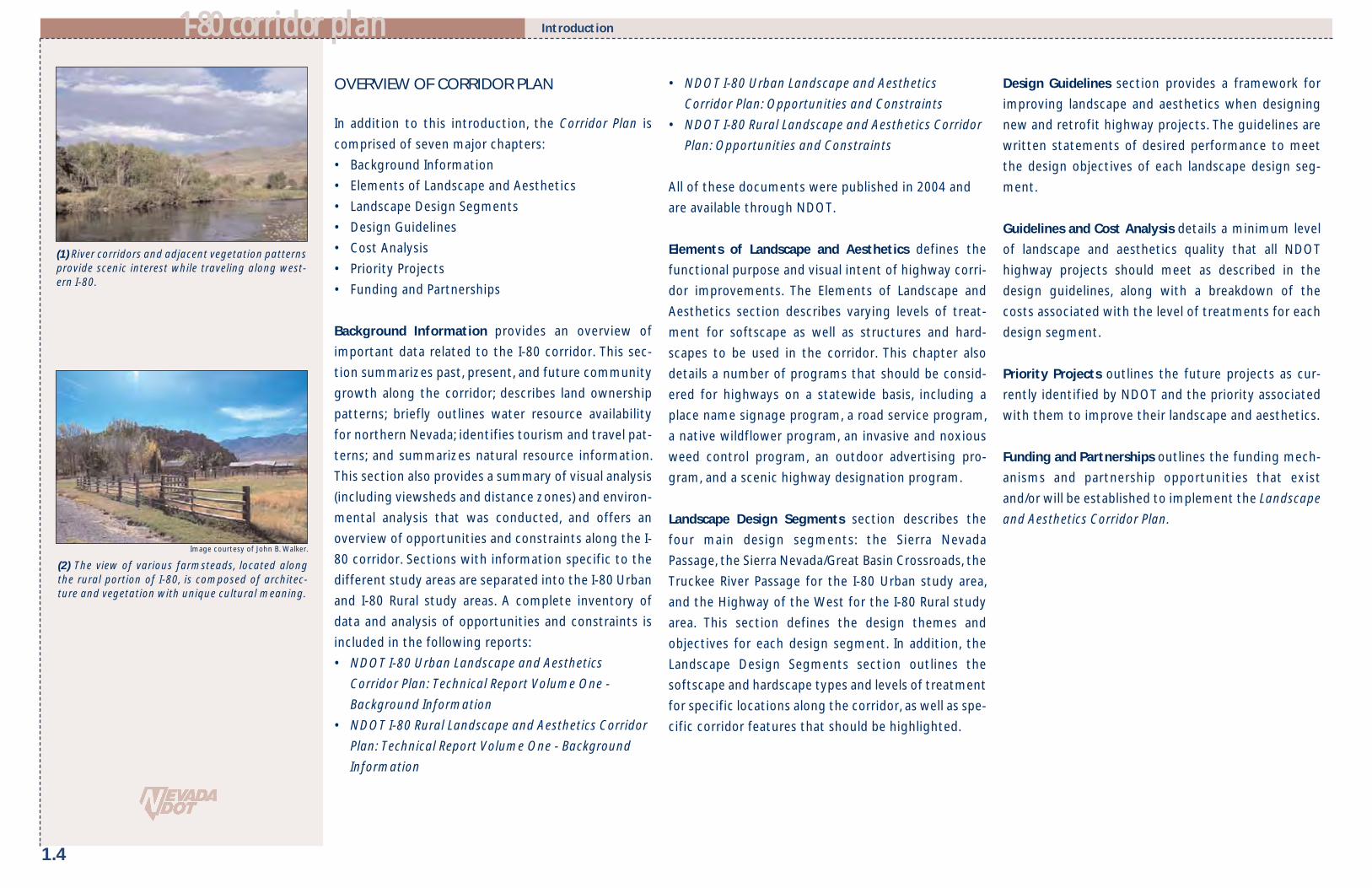
OVERVIEW OF CORRIDOR PLAN
In addition to this introduction, the Corridor Plan is
comprised of seven major chapters:
• Background Information
• Elements of Landscape and Aesthetics
• Landscape Design Segments
• Design Guidelines
• Cost Analysis
• Priority Projects
• Funding and Partnerships
Background Information provides an overview of
important data related to the I-80 corridor. This sec-
tion summarizes past, present, and future community
growth along the corridor; describes land ownership
patterns; briefly outlines water resource availability
for northern Nevada; identifies tourism and travel pat-
terns; and summarizes natural resource information.
This section also provides a summary of visual analysis
(including viewsheds and distance zones) and environ-
mental analysis that was conducted, and offers an
overview of opportunities and constraints along the I-
80 corridor. Sections with information specific to the
different study areas are separated into the I-80 Urban
and I-80 Rural study areas. A complete inventory of
data and analysis of opportunities and constraints is
included in the following reports:
• NDOT I-80 Urban Landscape and Aesthetics
Corridor Plan: Technical Report Volume One -
Background Information
• NDOT I-80 Rural Landscape and Aesthetics Corridor
Plan: Technical Report Volume One - Background
Information
• NDOT I-80 Urban Landscape and Aesthetics
Corridor Plan: Opportunities and Constraints
• NDOT I-80 Rural Landscape and Aesthetics Corridor
Plan: Opportunities and Constraints
All of these documents were published in 2004 and
are available through NDOT.
Elements of Landscape and Aesthetics defines the
functional purpose and visual intent of highway corri-
dor improvements. The Elements of Landscape and
Aesthetics section describes varying levels of treat-
ment for softscape as well as structures and hard-
scapes to be used in the corridor. This chapter also
details a number of programs that should be consid-
ered for highways on a statewide basis, including a
place name signage program, a road service program,
a native wildflower program, an invasive and noxious
weed control program, an outdoor advertising pro-
gram, and a scenic highway designation program.
Landscape Design Segments section describes the
four main design segments: the Sierra Nevada
Passage, the Sierra Nevada/Great Basin Crossroads, the
Truckee River Passage for the I-80 Urban study area,
and the Highway of the West for the I-80 Rural study
area. This section defines the design themes and
objectives for each design segment. In addition, the
Landscape Design Segments section outlines the
softscape and hardscape types and levels of treatment
for specific locations along the corridor, as well as spe-
cific corridor features that should be highlighted.
Design Guidelines section provides a framework for
improving landscape and aesthetics when designing
new and retrofit highway projects. The guidelines are
written statements of desired performance to meet
the design objectives of each landscape design seg-
ment.
Guidelines and Cost Analysis details a minimum level
of landscape and aesthetics quality that all NDOT
highway projects should meet as described in the
design guidelines, along with a breakdown of the
costs associated with the level of treatments for each
design segment.
Priority Projects outlines the future projects as cur-
rently identified by NDOT and the priority associated
with them to improve their landscape and aesthetics.
Funding and Partnerships outlines the funding mech-
anisms and partnership opportunities that exist
and/or will be established to implement the Landscape
and Aesthetics Corridor Plan.
Introduction
(1) River corridors and adjacent vegetation patternsprovide scenic interest while traveling along west-ern I-80.
(2) The view of various farmsteads, located alongthe rural portion of I-80, is composed of architec-ture and vegetation with unique cultural meaning.
Image courtesy of John B. Walker.

T o t a l I n c r e a s e i n P o p u l a t i o n2 0 0 3 t o 2 0 2 4 Carson City 10,408 Churchill County 10,734 Clark County 1,130,334 Douglas County 16,049 Elko County -2,003 Esmeralda County -193 Eureka County -58 Humboldt County -2,631 Lander County -1,971 Lincoln County 1,543 Lyon County 33,037 Mineral County -2,211 Nye County 21,014 Pershing County 181 Storey County -603 Washoe County 109,645 White Pine County -1,621 State Total 1,328,916
11--8800 ccoorrrriiddoorr ppllaann
2.1
PRESENT & FUTURE COMMUNITY GROWTH
Northern Nevada’s historic settlement is tied to trav-
el. A majority of communities along the I-80 corridor
were located along the California Emigrant Trail or
served as stopping points for the railroad. However,
settlement patterns and future growth differs for the
I-80 Urban and I-80 Rural study areas.
I-80 Urban Study AreaThe majority of growth in the greater Reno-Sparks
area has occurred just in the last 100 years. At the time
of this report, spring of 2005, Washoe County is esti-
mated to grow at 1.7%. Fernley and Lyon County
growth rates had an average annual rate of approxi-
mately 12% from 2002-2003. If similar trends contin-
ue, Lyon County would have a population of 74,000 by
the year 2024.
Settlement patterns along the urban area of the I-80
corridor are characterized by intense urban and sub-
urban development and growth through the greater
Reno-Sparks area. The Truckee Meadows appears to be
a single, urbanized area with new development on the
fringe areas. In addition, Fernley is developing into a
significant industrial boomtown in northern Nevada. A
growing number of industrial complexes are located
along the eastern edge of town.
I-80 Rural Study AreaAlong the rural portion of the corridor, communities
are characterized by low density residential develop-
ment with small commercial centers. Communities
include Lovelock, Winnemucca, Battle Mountain, Elko,
Wells, West Wendover, and McDermitt. Each town
has similar development and settlement patterns.
Commercial development is typically located within
close proximity to the highway, and traditional neigh-
borhood developments with gridded street patterns
form the town’s infrastructure. Mining, agriculture,
ranching, and tourism each play an economic role and
influence the rate of growth for the individual towns.
On average these communities have a slow growth
rate, and according to census data Elko County had a
negative growth rate of 2.6% between 2000 and 2003.
Outside of the communities outlined here, settlement
along I-80 and US-95 remains rural and is character-
ized by homesteads and/or ranches surrounded by
agricultural and open range land.
ANTICIPATED URBAN CHANGES
I-80 Urban Study AreaWithin Reno, Sparks, and Fernley, growth and land use
development have been significant and will continue
to influence the I-80 corridor. The anticipated urban-
ized changes over the next 20 years most likely to
influence the urban study area will occur in the Verdi
planning area within Washoe County, the City of Reno,
the City of Sparks, and the City of Fernley. The City of
Reno will annex land west of Reno up to and including
Verdi. Under an existing development plan, residential
and commercial suburban growth would extend along
the I-80 corridor from Reno’s current boundaries into
Verdi. This residential and commercial growth will like-
ly replace the current natural landscape and foothill
gateway.
I-80 Rural Study AreaGrowth and land use development have been cyclical,
reflecting the economic swings of the mining indus-
try. In fact, in most recent years some small settle-
ments, such as Lovelock and Battle Mountain, have
experienced an overall decline in population as a result
of the reduction of mining and related jobs.
Significant efforts have been made in communities,
such as Winnemucca and Elko, to improve job oppor-
tunities and expand tourism with the towns. However,
due to the population swings characteristic of
Nevada’s rural areas, future population estimates for
the communities within the rural study area are diffi-
cult to project. Visual impacts will primarily be related
to industrial and mining development along the
corridor.
LAND OWNERSHIP
The State of Nevada consists of 83% public land, thehighest percentage of federal lands among the con-tiguous 48 states (BLM, 2000). The Bureau of LandManagement (BLM) owns the bulk of the federal landswith small and large in-holdings of other public agen-cies and private landowners. In northern Nevada, landis managed by BLM, U.S. Forest Service (USFS), Bureauof Indian Affairs (BIA), and private landowners. Therural land adjacent to I-80 (outside of NDOT's right-of-way) belongs to the BLM and private landowners. Theland within the urbanized Reno-Sparks area and fromthe border of California to the eastern edge of Sparksis under private ownership. The USFS and BLM manageportions of the landscape in the hills and mountainsseen from the road. From the eastern edge of Sparksto Fernley, I-80 traverses a mixture of BLM and private
Background Information
(1) Population projections per Nevada StateDemographer, 2004.

2.2
11--8800 ccoorrrriiddoorr ppllaann
lands. Around Fernley, I-80 passes through the south-ern tip of the Pyramid Lake Indian Reservation. Thesmall Nevada towns along I-80 are primarily under pri-vate land ownership.
Land ownership affects land use and the visual charac-ter of the landscape. Public agencies such as BLM andthe USFS operate under a multiple-use mandate. Fromthe highway, drivers see evidence of grazing, mining,power generation, and tourism throughout the multi-ple-use federal lands. In the greater Reno-Sparks area,NDOT may have little influence over the visual charac-ter of the landscape outside of the right-of-way.NDOT may have influence over the visual character ofpublic lands adjacent to the right-of-way because ofthe possibility of interagency agreements. The landownership pattern that follows the I-80 corridor is acheckerboard pattern because of century-old agree-ments between railroads and the U.S. government.
WATER RESOURCE AVAILABILITY
The availability of adequate water resources and deliv-ery systems is a significant issue and may constrictdevelopable lands. This is a major issue, and particular-ly pertinent at the time of this report due to theextended drought period.
I-80 Urban Study AreaWater resources for the majority of the urban studyarea are administered by the Truckee Meadows WaterAuthority (TMWA). The 1997 Regional WaterManagement Plan indicates that the adequacy ofTruckee River water rights to meet future demands ofthe growing Reno-Sparks area is a constraint for devel-opment. The conversion of water rights is expected tobe exhausted between 2018-2048. The TMWA isembarking on the creation of a Water Resource Planfor 2005-2025, which will influence landscape ameni-
ties and the types of plant species now used in devel-opments.
I-80 Rural Study AreaCommunities throughout the rural study area arelocated great distances from one another. Therefore,adequate infrastructure for water distribution is a lim-iting factor for development along the corridor.Agriculture and mining are the largest water users inNevada’s rural areas. Domestic users generally obtaintheir water supply from private wells, springs, and/orsmall community water systems. As in Nevada’s metro-politan areas, the uncertain water resource availabilitywill require water-wise design for landscape aestheticprojects.
COMMUNITY SETTLEMENT PATTERNS
Throughout history, people everywhere have devel-oped attachments to various geographic locations,characterized by natural boundaries that are createdby physical, biological, social, cultural, and economicsystems. (Kent and Baharav, 2002, Kent and Preister,1999). Unique beliefs, traditions, and stories tie peopleto a specific place, to the land, and to social/kinshipnetworks, the reflection and function of which iscalled "culture."
The geography of settlement along Nevada's I-80 cor-ridor has been studied and mapped. The HumanGeographic Map of Nevada, included in Figure 2, isbased on the published result and definitions of theboundaries (Kent and Schultz, 1993, map updated in2000.) Social Resource Units are defined as the aggre-gation of small units characterized by cultural descrip-tions. Often a river basin, for example, is the basis ofshared history, lifestyle, livelihood, and outlook. Socialties are created by action around issues and commonvalues.
Social Resource Units are districts that represent theboundaries within which people already mobilize toprotect their social, economic, and social environment(see Figure 2). This group dynamic, known as place-based knowledge, creates and facilitates ownership-in-issue resolution, project planning and implementation,public participation, and public policy development.
TRAVEL AND TOURISM PATTERNS
Northern Nevada provides a host of tourism and trav-el opportunities ranging from indoor activities, suchas gaming or attending conventions, to outdoorrecreation, such as hiking or hunting. The I-80 corri-dor’s two study areas each offer unique tourismopportunities.
Background Information
(1) This annual precipitation map reveals howmuch of Nevada is arid. Nevada is the driest statein the US.
Figure 2
This figure represents major human geographic divisions inNevada that reflect common boundaries of the settlementpatterns.
LegendSocial Resource UnitBoundary

Background Information11--8800 ccoorrrriiddoorr ppllaann
I-80 Urban Study AreaThe Nevada Commission on Tourism coined the urbanstudy area from California to Wadsworth the “Reno-Tahoe Territory.” Fernley, and its immediate sur-roundings, are referred to as the “Pony ExpressTerritory.” Almost half of the visitors to the TruckeeMeadows classify their trip as vacation or pleasure.Entertainment and recreation opportunities can befound at one of many casinos, at golf courses, or alongthe Truckee River. Reno and Sparks also serve as a stag-ing ground, or jumping off points, to other populartourism destinations such as Lake Tahoe, PyramidLake, and Virginia City.
Of the 4.9 million visitors to the Truckee Meadows(2002), over 70% of the visitors travel annually by caralong the I-80 corridor. The majority of travelers’ des-tinations is within Reno and Sparks. Less than one percent of visitors are passing through to other desti-nations, and many decide on which attractions to visitonly after they have arrived.
I-80 Rural Study AreaThe majority of the I-80 rural study area is dominatedby a western culture and is aptly named “CowboyCountry Territory” by the Nevada Commission onTourism. Communities such as Lovelock, Winnemucca,Battle Mountain, Carlin, Elko, Wells, and WestWendover all have ties to the cowboy lifestyle, andoutdoor recreational opportunities are prevalent.Native American and other cultures, such as Basqueand Hispanic, create a rich diversity and add to thecorridor’s character. Tourism and recreational ameni-ties include gaming, golfing, hunting, and other out-door activities, as well as visiting historical towns,mining facilities, and museums. Towns also serve as ahome base for travelers touring the nearby State andFederal recreation areas. In addition, local community
events such as the National Cowboy Poetry Gatheringin Elko and the Humboldt County Fair and Stampede inWinnemucca draw visitors from across the nation.
I-80 is a vital connection and travel route to commu-nities along the rural study area. Although air travel isaccommodated in a few communities, the majority oftravelers utilize the interstate as a means of arrival.Providing travel information at rest areas, welcomecenters, and viewpoints is vital to improve the com-patibility between local communities and the highway.
NATURAL RESOURCES
Topography & Surface HydrologyNevada is one of the most mountainous states in theU.S., with over 314 named mountain ranges and 232basins that create a landscape rich in diversity. Nevadaconsists of four major ecosystem units, or ecoregions-—the Great Basin, Mojave Desert, Columbia Plateau,and Sierra Nevada. Of these, the Great Basin, SierraNevada and Columbia Plateau ecoregions are part ofthe I-80 corridor. The Great Basin covers about 48 mil-lion acres (68% of the state) and consists of a series ofdepressions, flats, dry lakes, marshy salt pans, andsinks that are scattered between ribbons of mountainranges. The Truckee River is a major river in the I-80urban study area, and the Humboldt River is a majorriver in the I-80 rural study area. Numerous perennialand ephemeral creeks and smaller rivers originate inthe high elevation ranges and flow down from themountains. A multitude of springs are located in thelower valleys (Nevada Natural Resources StatusReport, 2002).
Vegetation CommunitiesThe physiographic region primarily influencing vege-tation along I-80 is the Great Basin of northern
Nevada. In general, most of the land along the high-way is arid, with the exception of irrigated agricultur-al fields and areas where rivers and streams sustainpockets of riparian vegetation that includes willows,alders, dogwoods, and cottonwoods. Some areas ofsalt marsh do not provide fertile grounds for theestablishment of vegetation. The majority of I-80 trav-erses areas of sagebrush and salt desert scrubthroughout the lower elevations and pinyon andjuniper woodlands in the mountain ranges. Theextreme western portion crosses pine forests, andriparian communities are found along rivers andperennial and intermittent streams. Throughout theReno-Sparks area there is little native vegetation with-in the right-of-way.
The most prevalent vegetation community foundalong I-80 is the sagebrush/grass/rabbitbrush thatincludes Wyoming big sagebrush (Artemisia tridentatavar. wyomingensis), big basin sagebrush (Artemisia tri-dentata tridentata), and black sagebrush (Artemisianova) at lower elevations. Higher elevations includebig basin sagebrush (Artemisia tridentata tridentatavar. vaseyana) and low sagebrush (Artemisia arbusculaand Artemisia longiloba).
Wildlife and Wildlife HabitatNevada is renowned for its variety of wildlife and veg-
etative habitats that include more than 3800 plant
and animal species, and some of the most biologically
diverse eco-regions in North America. Nevada is
inhabited by a large number of species and subspecies
that are unique to the state.
Much of the land surrounding the I-80 corridor is part
of the Great Basin, and this land provides appropriate
habitat for large mammals. Mule deer is the most
2.3
(2) The I-80 Corridor passes through a variety ofplant communities ranging from salt desert scrubto pinyon and juniper woodlands.
(1) Salt desert scrub plant community is adjacent toportions of the I-80 corridor.

2.4
11--8800 ccoorrrriiddoorr ppllaann Background Information
common wild ungulate found in Nevada today, with a
population of more than 145,000, (NDOW, 2000). Elk
are currently found in several locations in northeast-
ern and central Nevada. Elk habitat exists throughout
the Ruby and Pequop Mountains and the East
Humboldt Range that is bisected by the I-80 corridor
near Elko, Wells, and West Wendover. The majority of
the rural portion of the I-80 corridor is in close prox-
imity to antelope habitat. There are approximately
16,000 Pronghorn antelope in the state. However, the
number has declined over the last several decades due
to over-hunting, habitat conversion, and competition
with livestock. Habitat is located north of Reno
throughout the Spanish Springs Valley and north of
Stead. Bighorn sheep are one of the most distinctive
and easily recognizable desert animals. A small habitat
area is located east of Lovelock in the Stillwater Range,
and other Bighorn sheep populations are located
throughout the state.
Wildlife movement corridors are composed of con-
tiguous habitat that provides shelter and food sources
for resident and migratory wildlife species. Deer corri-
dors cover a large area from the Nevada/California
border towards Mogul. Throughout the majority of
the rural study area, deer corridors parallel and cross
the highway. Numerous movement corridors are
located throughout the rural study area. There are no
documented wildlife movement corridors that cross I-
80 around highly developed areas in Reno and Sparks.
An antelope corridor follows the Truckee River from
Wadsworth to Pyramid Lake, and wildlife have been
observed crossing I-80 through the Truckee River
Canyon.
VIEWSHEDS AND DISTANCE ZONES
Viewshed refers to all areas that are visible from a sec-
tion of highway. Similar to the boundaries of a water-
shed, the boundaries of viewsheds are usually high
points in the landscape, such as ridges and hills.
Distance zones, including foreground zones, middle
ground zones and background zones, define the view-
ing distances of the traveler.
Viewsheds are determined by analyzing digital eleva-
tion models in a Geographic Information Systems
(GIS) program. All areas that are visible from the high-
way are combined to create the viewshed. Distance
Zones are delineated through a process developed by
the USFS that relates the detail and importance of dis-
tance to the driver on the highway.
Viewsheds and Distance Zones along the I-80 corridor
are shown on the maps beginning on page 2.5. Darker
shading corresponds to areas that can be seen more
often from points along the highway (Figure 3). These
areas usually coincide with landscapes of high visual
quality and scenic value such as mountain ranges.
Management of these areas through multi-jurisdic-
tional cooperation can protect them from billboards
and other land uses that obstruct views and detract
from the travel experience.
(1) This bridge on I-70 near the continental divide inColorado was constructed without center piers toframe the view of the mountain range beyond. Thisunderpass window enhances the view for the driverand creates a focus on high visual quality.
Figure 3
This figure describes the concept of a viewshedand how a viewshed analysis is conducted.
Viewpoint locatedalong highway
Area of landscape seenfrom one viewpoint
Area of landscape seenfrom two viewpoints
Area of landscapemost seen by thissection of highway

Background Information11--8800 ccoorrrriiddoorr ppllaann
VISUAL ANALYSIS
A visual analysis was conducted along the I-80 corridor
to evaluate existing views from the highway and rank
them relative to their quality. Scenic features are
identified and highly visible landforms, such as moun-
tain ranges and unique cliffs, are located. This analyisis
is shown on Maps F-J: Visual Analysis. The landscape
was divided into intrinsic landscape districts based
upon spatial characteristics defined by topography.
Areas of highest scenic value include:
• The Carson Mountain Range, southwest of Reno
• The Truckee River Canyon
• The West Humboldt Mountain Range and Lone
Mountain
• Paradise Valley
• Basin and Range transition scenery
ENVIRONMENTAL ANALYSIS
The landscape of northern Nevada has many special
environmental features, including plant communities,
rivers, lakes, wetlands, playas, wildlife, rock outcrop-
pings, cliffs, and mountain ranges. To analyze the envi-
ronmental features, data was gathered from a variety
of sources and analyzed according to its relationship
to the I-80 corridor. Unique features visible from the
highway or that influence the highway were mapped
(see Environmental Analysis Maps K-O on pages 2.16-
2.20). Environmental features provide an opportunity
to create pull-offs to view the feature, preserve natu-
ral systems, and enhance wildlife movement corridors.
Public agency coordination is essential to maintain
visual and environmental quality management. This
may affect land use decisions, facility placement, and
environmental standards utilized on adjacent lands.
2.5

2.6
VIEWSHED AND DISTANCE ZONESI-80: VERDI TO FERNLEY
MAPA
11--8800 ccoorrrriiddoorr ppllaann

2.7
VIEWSHED AND DISTANCE ZONESI-80: FERNLEY TO RYE PATCH
MAPB
11--8800 ccoorrrriiddoorr ppllaann

2.8
VIEWSHED AND DISTANCE ZONESI-80: RYE PATCH TO TYROL
MAPC
11--8800 ccoorrrriiddoorr ppllaann

2.9
VIEWSHED AND DISTANCE ZONESI-80: TYROL TO WEST WENDOVER
MAPD
11--8800 ccoorrrriiddoorr ppllaann

2.10
VIEWSHED AND DISTANCE ZONESUS 95: WINNEMUCCA TO MCDERMITT
MAPE
11--8800 ccoorrrriiddoorr ppllaann

2.11
VISUAL ANALYSISI-80: VERDI TO FERNLEY
MAPF
11--8800 ccoorrrriiddoorr ppllaann

2.12
VISUAL ANALYSISI-80: FERNLEY TO RYE PATCH
MAPG
11--8800 ccoorrrriiddoorr ppllaann

2.13
VISUAL ANALYSISI-80: RYE PATCH TO TYROL
MAPH
11--8800 ccoorrrriiddoorr ppllaann

2.14
VISUAL ANALYSISI-80: TYROL TO WEST WENDOVER
MAPI
11--8800 ccoorrrriiddoorr ppllaann

2.15
VISUAL ANALYSISUS 95: WINNEMUCCA TO MCDERMITT
MAPJ
11--8800 ccoorrrriiddoorr ppllaann

2.16
ENVIRONMENTAL ANALYSISI-80: VERDI TO FERNLEY
MAPK
11--8800 ccoorrrriiddoorr ppllaann

2.17
ENVIRONMENTAL ANALYSISI-80: FERNLEY TO RYE PATCH
MAPL
11--8800 ccoorrrriiddoorr ppllaann

2.18
MAPM ENVIRONMENTAL ANALYSIS
I-80: RYE PATCH TO TYROL
11--8800 ccoorrrriiddoorr ppllaann

2.19
ENVIRONMENTAL ANALYSISI-80: TYROL TO WEST WENDOVER
MAPN
11--8800 ccoorrrriiddoorr ppllaann

2.20
ENVIRONMENTAL ANALYSISUS 95: WINNEMUCCA TO MCDERMITT
MAPO
11--8800 ccoorrrriiddoorr ppllaann

11--8800 ccoorrrriiddoorr ppllaann
3.1
Elements of Landscape and Aesthetics
ELEMENTS OF LANDSCAPE AND AESTHETICS
The Elements of Landscape and Aesthetics define the
functional purpose and visual intent of highway corri-
dor improvements. The elements are represented by a
variety of different components, including varying
intensities of softscape, structures and hardscape;
state-wide signage; rest area facilities; and many other
items that affect visual quality within the corridor. To
create a standardized understanding of the Corridor
Plan, the following pages describe each of the ele-
ments.
While NDOT currently incorporates some of these ele-ments, the descriptions in this section redefine theapplication of existing programs and establish newfacility types. Following the component descriptions,each Landscape Design Segment is detailed. Designobjectives, specific to each segment, are introduced atthe beginning. Landscape and aesthetic ele
ments that support the design objectives are thenexplicitly located and identified within each designsegment.
Identifying a specific Landscape Treatment type is thefirst Element of Landscape and Aesthetics and is com-posed of a softscape designation and a structures andhardscape type. Every square foot of NDOT right-of-way has a Landscape Treatment type associated withit to define its design character and maintenancerequirements. Softscape types are defined by a hierar-chy of treatment levels, each with an establisheddesign intent. In a similar way, structures and hard-scape treatments have been defined from the stan-dard type to those with landmark quality for all NDOTright-of-way areas, from the standard type to thosewith landmark quality. Used in combination, thesetreatment levels will establish the design characterwithin the corridor. The matrix of possible combina-tions of softscape types and structures and hardscapetreatments is shown in Figure 4.
GROUND TREATMENT
NATIVE PLANT REVEGETATION
ENHANCED NATIVE
REGIONALLY ADAPTED
REGIONAL ORNAMENTAL
STA
ND
ARD
ACC
ENTU
ATE
D
FOCA
L
LAN
DM
ARK
STRUCTURES AND HARDSCAPE TYPES AND TREATMENTS
SOFT
SCA
PE
TYPE
S A
ND
TRE
ATM
ENTS
Comprehensive Design Concept
The corridor design concept can be articu-lated for both rural and urban segments.In rural or predominately undevelopedareas, the highway should blend into thenatural landscape. The presence of theroad is muted by design interpretationsincluding naturally occurring patterns ofgeology, vegetation, and soils. The suc-cessful emulation of these patterns willresult in a landscape environment thatincludes the highway avoiding the distinc-tive separation between road and land.
In urban interstate highway segments,the highway is a major component of thecharacter of the city. In fact, our percep-tion of urban places is shaped by a high-way’s design and its features. Respectingadjacent communities and creating acoherent visual environment that buildsunity into the urban fabric are key to thesuccess of the urban highway system. Thehighway should provide a composition offocused punctuation at important placesand transitional edges compatible to sur-rounding urban communities.
Figure 4
LANDSCAPE TREATMENT TYPES

3.2
11--8800 ccoorrrriiddoorr ppllaann
SOFTSCAPE TYPES AND TREATMENTS
The following softscape treatments are descriptive planting types
that define the design intent for future projects. These treatments
are compositions of plant materials that include trees, shrubs,
perennials, grasses, and ground treatments. The descriptions and
photographic examples define the specific softscape types that
may be utilized in a section of the corridor.
Elements of Landscape and Aesthetics
GROUND TREATMENT SOFTSCAPEErosion control and dust control are a major function of all groundtreatments along the roadway. Rock mulches should be usedbeneath all softscape treatments, including native seed and con-tainer-planted natives and/or ornamentals. Uniform applications ofrock mulch or variable sizes of stone and textures are available tomatch the existing environment. Example palettes are derivedfrom natural patterns found in playas, foothills, or ephemeraldrainages. In urban settings, various forms of aesthetic rock treat-ments are used to create patterns and textures. Irrigation is notincluded in this treatment. Soil stabilizer may be used in conjunc-tion with these methods.
NATIVE PLANT REVEGETATION SOFTSCAPEReturning roadway construction disturbance back to its nativedesert condition requires the use of a native Great Basin plantpalette. This palette includes native communities such as theSagebrush/Rabbitbrush or Pinyon/Juniper. The spacing and fre-quency of native plant distributions is sparse and individual plantsare widely separated by scattered native rock mulch. Temporaryirrigation may be needed to assure plant establishment, howeverthis softscape type does not rely on permanent irrigation.Preparation techniques such as roughening grade for seed sitingand amendments like top soil and mulch are required to enrich soiland protect against winds. Along with seeding, some matureplants may be used to provide an established plant communitycharacter.
Note: These photographs are illustrative examples of the softscape types and treatments.
(1)
(1)
(2) (3) (4)
(2) (3)
Total Cost: $1.15 - $1.35 sf L & A Cost: $0.00 sf
Total Cost: $1.15 - $1.35 sf L & A Cost: $0.00 sf
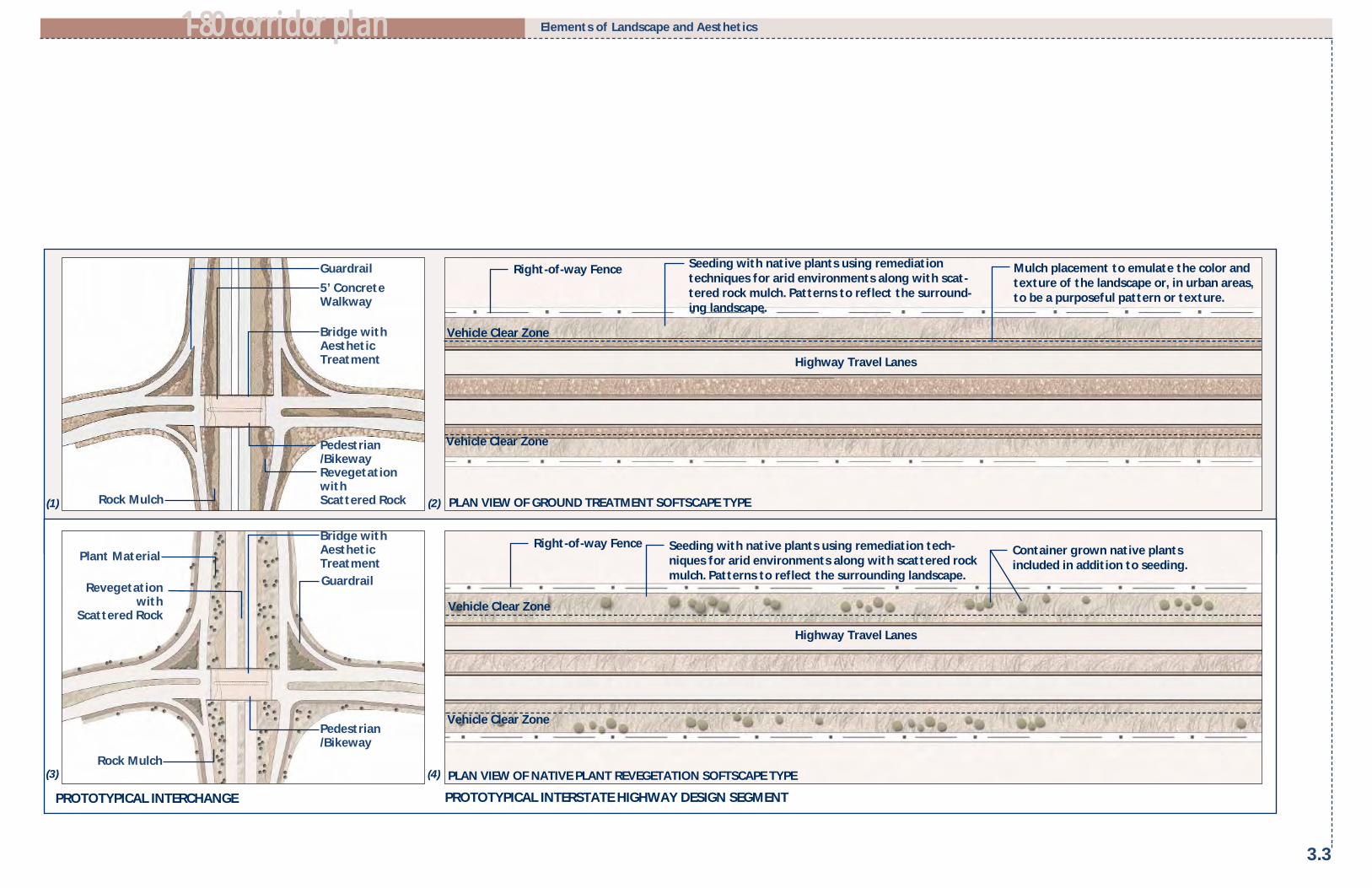
11--8800 ccoorrrriiddoorr ppllaann
3.3
Elements of Landscape and Aesthetics
PROTOTYPICAL INTERSTATE HIGHWAY DESIGN SEGMENT
Right-of-way Fence Seeding with native plants using remediationtechniques for arid environments along with scat-tered rock mulch. Patterns to reflect the surround-ing landscape.
Highway Travel Lanes
Mulch placement to emulate the color andtexture of the landscape or, in urban areas,to be a purposeful pattern or texture.
Right-of-way Fence
PLAN VIEW OF NATIVE PLANT REVEGETATION SOFTSCAPE TYPE
PLAN VIEW OF GROUND TREATMENT SOFTSCAPE TYPE
Highway Travel Lanes
Seeding with native plants using remediation tech-niques for arid environments along with scattered rockmulch. Patterns to reflect the surrounding landscape.
Container grown native plantsincluded in addition to seeding.
PROTOTYPICAL INTERCHANGE
(1) (2)
(3) (4)
5’ ConcreteWalkway
Guardrail
Pedestrian/Bikeway
Bridge withAestheticTreatment
Revegetationwith Scattered Rock
Pedestrian/Bikeway
Rock Mulch
Plant Material
Bridge withAestheticTreatment
Revegetationwith
Scattered Rock
Rock Mulch
Guardrail
Vehicle Clear Zone
Vehicle Clear Zone
Vehicle Clear Zone
Vehicle Clear Zone

3.4
11--8800 ccoorrrriiddoorr ppllaann Elements of Landscape and Aesthetics
REGIONALLY ADAPTED SOFTSCAPECombinations of Great Basin plants and those from other dryland environments form this landscape palette. Plants are com-bined in greater density and with layers of overstory trees,understory shrubs or perennials, and scattered native rock mulch.The expanded plant palette includes plants selected for form,seasonal change, special texture, and color. Great Basin adaptedplants in this softscape type offer a desert garden quality andprovide a full array of enriched landscape character. Drip irriga-tion to individual plants is required for this softscape type.
REGIONAL ORNAMENTAL SOFTSCAPE Regional ornamental softscape is delineated by a high diversity ofplant species, including those which are imported to this region.Ornamental softscape introduces taller and denser plant materialssuch as landmark deciduous trees similar in form to cottonwoodsand poplars. Regional ornamental softscapes include shade fromoverstory trees, contain a wide variety of form and color, and cre-ate dynamic contrasts to the arid landscapes of naturally occurringplant species, along with scattered rock mulch. Patterns of plantsand compositions of arrangements are not derived from naturallyoccurring communities. Rather, they are intended to be landscapesof cultural meaning. Drip irrigation systems are required for indi-vidual plants.
ENHANCED NATIVE SOFTSCAPEThis treatment accentuates change by introducing more typesand species of plants to the Great Basin/Sierra Nevada revegeta-tion plant palette, providing greater coverage and plant densitiesalong with scattered native rock mulch. Adapted trees are usedto increase vertical diversity. Special ground treatments areincluded for drainage and erosion control such as rip-rap and soilstabilizers. Supplemental irrigation is required to assure plantsurvival.
SOFTSCAPE TYPES AND TREATMENTS
Note: These photographs are illustrative examples of the softscape types and treatments.
(1) (2) (3)
(1) (2) (3) (4)
(1) (2) (3)
Total Cost: $1.40 - $1.60 sf L & A Cost: $0.25 sf
Total Cost: $2.25 - $2.75 sf L & A Cost: $1.10 - $1.60 sf
Total Cost: $3.50 - $6.00 sf L & A Cost: $2.35 - $4.85 sf

11--8800 ccoorrrriiddoorr ppllaann
3.5
Elements of Landscape and Aesthetics
PROTOTYPICAL INTERSTATE HIGHWAY DESIGN SEGMENT
Right-of-way Fence
PLAN VIEW OF ENHANCED NATIVE SOFTSCAPE TYPE
Highway Travel Lanes
Native Seed Mix withscattered mulch
Shrubs / Perennials Great BasinAdapted Trees
PLAN VIEW OF REGIONALLY ADAPTED SOFTSCAPE TYPE
PLAN VIEW OF REGIONAL ORNAMENTAL SOFTSCAPE TYPE
Right-of-way Fence Native Seed Mix withscattered mulch
Shrubs / Perennials Great Basin AdaptedTrees Decorative Boulders
Right-of-way Fence Ornamental Trees Ornamental TreesShrubs / Perennials Decorative Boulders
Highway Travel Lanes
Highway Travel Lanes
PROTOTYPICAL INTERCHANGE
(1) (2)
(3) (4)
(6) (5)
Pedestrian/Bikeway
GuardrailGroundcover/Shrubs
Rock Mulch
Tree Bridge withAestheticTreatment
Revegetationwith
Scattered Rock
Pedestrian/Bikeway
Groundcover/Shrubs
Rock Mulch
Tree Bridge withAestheticTreatment
Revegetationwith
Scattered RockRetainingWall
LandscapeLight
Pedestrian/Bikeway
GuardrailGroundcover/
Shrubs
Rock Mulch
Tree Bridge withAestheticTreatment
Revegetationwith
Scattered Rock
RetainingWall
LandscapeLight
Accent Tree
Vehicle Clear Zone
Vehicle Clear Zone
Vehicle Clear Zone
Vehicle Clear Zone
Vehicle Clear Zone
Vehicle Clear Zone
Note: Refer to Cost Analysis pages 6.1 - 6.5 for more information on these illustrations.

3.6
11--8800 ccoorrrriiddoorr ppllaann Elements of Landscape and Aesthetics
STANDARD STRUCTURES AND HARDSCAPEA standard treatment is simple, straightforward, and functional.Attention to color and proportion can improve aesthetic qualitywithout increasing cost. Standard structures are economical intheir design and satisfy the requirements of vehicle movement,but elaborate little on the establishment of design character orplace-making. A regular maintenance program for trash and graf-fiti removal is imperative. A stained finish on concrete or a paint-ed finish on steel are the standard NDOT surface treatments.
ACCENTUATED STRUCTURES AND HARDSCAPEThis type of treatment builds place character and enhancesappearance by adding special accents and finishes to built struc-tures. A unified system of materials and textures define corridorpattern design. Transportation art may be applied and upgradedfinishes and colors for structures are included. Decorative rockfor drainage or aesthetics is included. Special contour grading isused to create desired land shape, and drainage features thatharvest water may be features of the hardscape design.
STRUCTURES AND HARDSCAPE TYPES AND TREATMENTS
The following classifications are a common language for aesthet-
ics of highway facility design. The treatments included are for
bridges, retaining walls, acoustic walls, pedestrian crossings, rail-
ings, barrier railings, lighting, and transportation art.
Note: These photographs are illustrative examples of the structures and hardscape types and treatments.
(1) (2) (4)
(1) (2) (3) (4)
(3) Total Cost: $110 - $115 sf L & A Cost: $0 sf
Total Cost: $125 - $135 sf L & A Cost: $15 - $25 sf

11--8800 ccoorrrriiddoorr ppllaann
3.7
Elements of Landscape and Aesthetics
FOCAL STRUCTURES AND HARDSCAPEFocal structures and hardscape type treatments provide a singularexpression for a project with a specific design character. Structuresare constructed of self-weathering materials, integrated color ortextural finishes, and may include the use of form liner imprints onstructural surfaces. Patterns may be created by using multiple sur-faces. Barrier rails utilize custom construction and include designsthat are artistically incorporated into the structure, elevating engi-neering to an art form. Upgraded lighting includes lighting withdecorative elements serving both a functional and aesthetic pur-pose.
LANDMARK STRUCTURES AND HARDSCAPELandmark, the most enhanced level of structures and hardscapetreatments, truly explores the possibilities of the place. Landmarktreatment calls attention to custom features and highlights uniqueelements. Extensive aesthetic treatments are used on all bridgestructures, retaining walls, acoustic walls, barrier rails, and pedes-trian crossings. Special significance is exhibited through one-of-a-kind form liner treatments on structural surfaces. Transportationart is prominent and evocative in subject and composition.Elaborate lighting includes special effects for night time beyondwhat may be necessary to provide for safety.
Note: These photographs are illustrative examples of the structures and hardscape types and treatments.
(1) (2) (3) (4)
(1) (2) (3) (4) (5)
Total Cost: $170 - $185 sf L & A Cost: $60 - $75 sf
Total Cost: $210 - $250 sf L & A Cost: $100 - $140 sf

NEVADA PLACE NAME SIGN PROGRAM
As part of the Elements of Landscape and Aesthetics, anew statewide place name and point-of-interest signprogram distinctive to the State of Nevada will bedesigned to better connect people to places.
Benefits of the ProgramThe State of Nevada is a large geographic area withdiverse and sometimes well-hidden features. The signprogram will provide clear and consistent directionfrom the corridors to scenic areas, points-of-interest,historical sites, and local attractions. The signs willwelcome visitors and inform residents, drawing atten-tion to these important assets and affirming the richhistory and physical attributes of the state while stim-ulating local economies. The sign program willencourage visitors and residents to gain a betterunderstanding of the history, culture, and geology ofthe state. The signs, consistent in color and material,will unify the roadway. Place name signs will be ofhigh quality and will be as durable as other standardhighway signs.
How the Program Will WorkUtilizing the current Federal Manual on UniformTraffic Control Devices (MUTCD) as a base, a cus-tomized and distinctive set of iconic symbols specificto Nevada will be designed for use on standardizeddirectional and identification signs. To insure unifor-mity and consistency, a State managed and controlledpolicy manual for the signs will be implemented. Themanual will be referred to as the Nevada Place NameSign Manual. The program will be promoted throughinformational brochures available at welcome centers,identification on state maps, and other locally basedadvertisements. Symbols used to provide directions
and mark points of interest will be recognizable picto-rials that are specific to the special point of interest.Federal Highway Administration (FHWA) approval forthe Nevada Place Name Sign Program will be gainedprior to installation.
EligibilityWith a State managed and controlled program, an ini-tial inventory of categories common to the state, aswell as features specific to each interstate corridor,will be established and approved by NDOT. After theinitial inventory is confirmed, state and local entitieswill be permitted to apply for inclusion based on spe-cific criteria.
Anticipated CategoriesPossible categories for sign icons common to theState of Nevada include, but are not limited to:• Historical Features and Sites such as railroads,
mines, mining towns, logging flume, ComstockLode, ghost towns, explorers, emigrant trails, etc.
• Wildlife Viewing Areas• Flora• Geographic Features• Geological Places of Interest• Landmarks• Cultural Resources• Museums
Specific areas of interest in I-80 corridor include, butare not limited to:• Truckee River• California Emigrant Trail• Mount Rose• Virginia City• Pyramid Lake• Lake Tahoe
• Reno Downtown• Victoria Square• University of Nevada• Derby Diversion Dam• Forty-mile Desert• Applegate-Lassen Cutoff Trail• Rye Patch State Recreation Area• Wild Horse State Reservoir• South Fork State Recreation Area• Humboldt River• Humboldt Toiyabe National Forest• Unionville (silver mining) • Ruby Mountains Wilderness• Pilot Peak • Wendover Air Force Auxiliary Field• Metropolis (ghost town)
Associated CostThe sign program is expected to have a direct eco-nomic benefit to smaller communities and localattractions. Through increased tax revenue, the Statewill recognize a tangible return on its investment.Partnering with businesses is possible through spon-sorship providing partial cost offsets.
Signs Included in the Program
Exit to Area of Interest or TownThis primary sign type will be used as an information-al listing located in advance of interstate exits. It willillustrate iconic symbols and descriptions as well asthe interstate exit number (see illustration 7, page 3.9).
Signs will be post-mounted and use reflective graph-ics/lettering on a metal panel in accordance withapplicable FHWA safety standards. A maximum of four
3.8
Elements of Landscape and Aesthetics 11--8800 ccoorrrriiddoorr ppllaann
(1) Wildlife Viewing (2) Ghost Town: Metropolis
(3) Pilot Peak was an important landmark forEmigrant Trail travelers.
(4) Railroads helped shape communities along I-80.

11--8800 ccoorrrriiddoorr ppllaann
3.9
Elements of Landscape and Aesthetics
(4) symbols will be used on each sign. Written descrip-tions are required to accompany iconic symbols.
Directional Sign On State or County Road
This secondary sign type will be used as an informa-
tional listing located on state or county roads or inter-
sections. It will feature iconic symbols, descriptions,
and a directional arrow (see illustration 8).
Signs will be post-mounted and use reflective graph-ics/lettering on a metal panel in accordance withapplicable FHWA safety standards. A maximum of four(4) symbols to be used on each sign—one (1) per panel.Written descriptions are required to accompany icon-ic symbols.
Scenic Area or Outlook Pull-off
This sign type will be located prior to pull-offs, illus-
trating iconic symbols and descriptions as well as the
distance to the pull-off (see illustration 9).
Signs will be post-mounted and use reflective graph-ics/lettering on a metal panel in accordance withapplicable FHWA safety standards. A maximum of two(2) symbols to be used on each sign. Written descrip-tions are required to accompany iconic symbols.
(1) Sign for Deer (ViewingArea)
(2) Sign for Mining Area (3) Sign for Truckee River
(4) Sign for Historic Rail (6) Sign for Mount Rose
(7) Sign for exit to area of interest or town (8) Place name sign on a state or county road (9) Sign for scenic area or outlook pull-off
CUSTOM SIGN ICONIC SYMBOLS
(5) Sign for Humboldt River
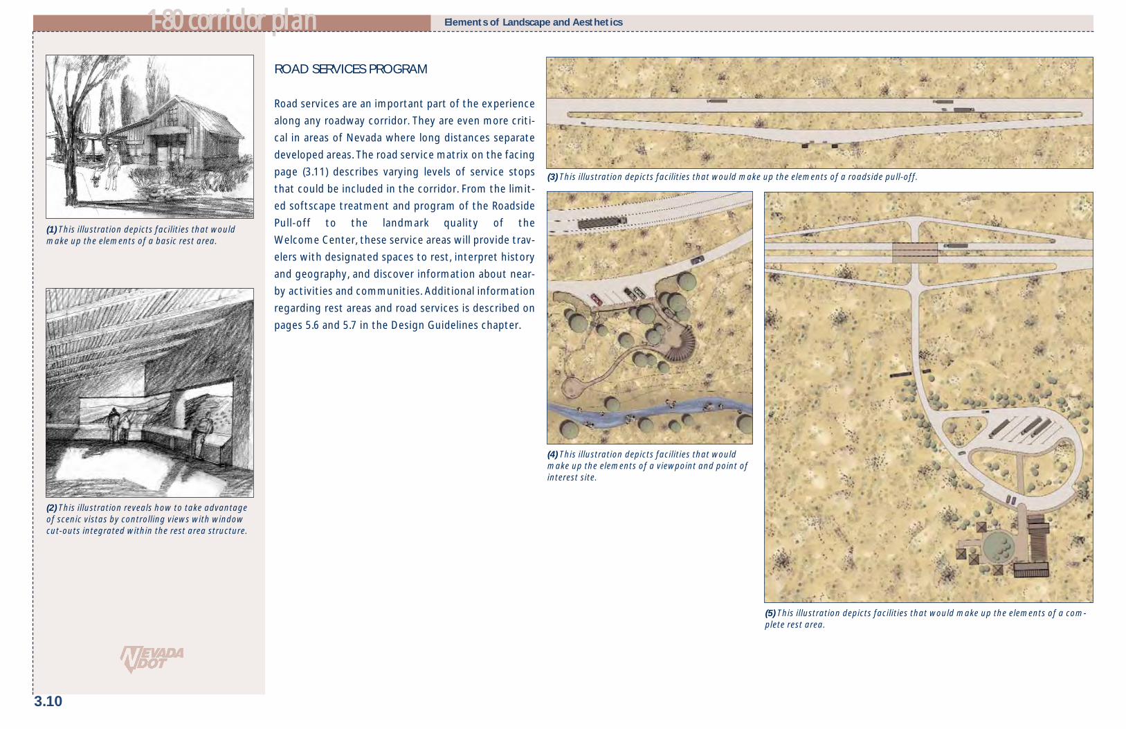
ROAD SERVICES PROGRAM
Road services are an important part of the experience
along any roadway corridor. They are even more criti-
cal in areas of Nevada where long distances separate
developed areas. The road service matrix on the facing
page (3.11) describes varying levels of service stops
that could be included in the corridor. From the limit-
ed softscape treatment and program of the Roadside
Pull-off to the landmark quality of the
Welcome Center, these service areas will provide trav-
elers with designated spaces to rest, interpret history
and geography, and discover information about near-
by activities and communities. Additional information
regarding rest areas and road services is described on
pages 5.6 and 5.7 in the Design Guidelines chapter.
3.10
11--8800 ccoorrrriiddoorr ppllaann Elements of Landscape and Aesthetics
(1) This illustration depicts facilities that wouldmake up the elements of a basic rest area.
(5) This illustration depicts facilities that would make up the elements of a com-plete rest area.
(4) This illustration depicts facilities that wouldmake up the elements of a viewpoint and point ofinterest site.
(2) This illustration reveals how to take advantageof scenic vistas by controlling views with windowcut-outs integrated within the rest area structure.
(3) This illustration depicts facilities that would make up the elements of a roadside pull-off.

11--8800 ccoorrrriiddoorr ppllaann
3.11
Elements of Landscape and Aesthetics
ROADSIDE PULL-OFF
BASIC REST AREA
COMPLETEREST AREA
WELCOME CENTER
GATEWAY REST AREA
Roadside pull-offs provide facilities for drivers to exit the high-way for a brief period. Facilities that respond to the landscapecharacter and minimal parking are provided to accommodatethe abbreviated stay. (Referred to as “Rest Stop” under formerNDOT naming conventions.)
• Native plant revegetation toenhanced native softscape types
• Standard hardscape type
• Site-specific interpretive signage• Toilets/no running water (where
associated with truck pull-offs)• Trash containers• Limited car and recreational
vehicle parking• Limited/temporary truck parking
• Scenic overlooks• Located according to travelers’
needs and unique features• Shade canopy (vegetation or structure)
• Trash containers• Paved car and recreational
vehicle parking• Paved truck parking• Nature walks or short trails• Seating Areas• Shade canopy (vegetation or structure)• Local community information
• Recreational vehicle dump station• Paved car and recreational
vehicle parking• Paved truck parking• Telescopes/viewfinders• Interpretive and overlook features• Children’s play area• Pet rest facilities & waste dispensers• Shade canopy (vegetation or structure)• Local community information
• Trash containers and recycle containers• Bicycle storage units• Paved car and recreational
vehicle parking• Paved truck parking• Improved trails• Children’s play area• Pet rest facilities & waste dispensers• Shade canopy (vegetation or structure)• Telescopes/viewfinders
• Located according to traveler’sneeds and unique site features
• Site-specific interpretive signage• Toilets/no running water (only
where available)• Emergency call box• Handicap accessible• Picnic tables and shade structures
• Regional interpretive signage• Running water and flushing toilets• Emergency call box and telephones• Drinking fountains• Vending machine services (at
manned sites)• Handicap accessible• Picnic tables and shade structures• Trash containers• Bicycle storage units
Program elements are consistent withthe type of Road Service Area provided.
Specific elements include:• Regional services information• Interpretation of regional sites and
features• Information on regional recreational
attractions
• Located at major entry routes to state• Informational services• Staffed visitor center• Statewide interpretive signage• Running water/flushing toilets• Emergency call box and telephones• Drinking fountains• Vending machine services• Handicap accessible• Picnic areas and shade structures
Basic rest areas are located throughout the state offering sitespecific interpretive information. They have limited rest roomfacilities which may or may not include running water, depend-ing on availability. Typically, these rest areas are located to takeadvantage of scenic views, unique historical, cultural or environ-mental features, and to provide travelers’ resting places enroute.
• Enhanced native softscape type• Standard to accentuated hardscape
types
Complete rest areas are located at 60-mile intervals throughoutthe state and are typically situated outside of developed areas.They feature modern facilities along with interpretive informa-tion on regionally significant cultural and historical sites.Complete rest areas also provide travelers with picnic facilitiesand include children’s play areas and pet areas.
• Regionally adapted softscape type• Accentuated to focal hardscape
type
As entryways, the gateway facilities convey first and lastimpressions and identity. Special features may be incorporatedinto the design to highlight the area through design interpre-tation of the place and gateways may be associated with anylevel of rest area in the listing. The incorporation of local com-munity information regarding amenities, events, and interpre-tative elements improves the interface between the highwayand the communities it serves.
• Regionally adapted softscape type• Focal hardscape type
Welcome centers are located along major entry routes to thestate. They offer introductions to the state where travelers canhave access to useful travel information. Welcome centersinclude a staffed information kiosk.
• Regionally adapted softscape type• Landmark hardscape type
Description Landscape Treatment Program Elements
VIEWPOINTSAND POINTS OF
INTEREST
• Nature walks or short trails• Seating areas• Shade canopy (vegetation or structure)• Limited/temporary truck parking (if con-
ditions permit)
• Located according to travelers’needs and unique site features
• Site-specific interpretive signage• Toilets/no running water• Handicap accessible• Picnic tables and shade structures• Trash containers• Paved car and recreational
vehicle parking• Telescopes/viewfinders
Viewpoints and points of interests present opportunities toview unique vistas, special natural resources, historical features,or cultural landmarks. Interpretive elements are integrated intothe site design, and Place Name Signage and Travel Informationelements are provided to establish the relationship betweenhighway and place. Typically, the length of stay is short and park-ing is limited. Travelers are provided with a detailed look at thesite or point of interest.
• Native plant revegetation to enhanced native softscape types
• Standard to accentuated hardscapetypes
ROAD SERVICES PROGRAM

NATIVE WILDFLOWER PROGRAM
Inspired by a vision of native plant species along
rights-of-way to enhance the beauty and connectivity
to the land, the Federal Highway Administration has
adopted two programs to promote the use of forbs
and grasses that naturally occur in a particular region,
state, or ecosystem. In 1987, the Surface
Transportation and Uniform Relocation Assistance Act
(STURAA) required that at least one-quarter of one
percent of funds expended for any Federal-aid high-
way system landscape project be utilized for native
wildflowers plantings. In addition to improved aes-
thetics, native forbs and grasses can also provide:
• Reduced maintenance requirements for estab-
lished native plants in comparison with non-native
species.
• Reduced roadside fire hazards.
• Reduced use of herbicides when native plants are
successfully established.
• Improved erosion control through drought-
tolerant species.
• Improved relationship between the highway corri-
dor and the regional character of the landscape.
A revegetation study conducted by the University of
Nevada supports the use of forbs and grasses along
highway right-of-ways. A list of forbs and grasses that
are appropriate to specific regions and ecosystems
and require “little or no maintenance...(and) create
defensible space for wildfire along the highway corri-
dors” was provided (Tueller, Post Noonan, 2002). As
part of the wildflower program, these suggested
plants should be utilized with others that do not cre-
ate a fire hazard or overly attract wildlife.
INVASIVE AND NOXIOUS WEED CONTROL
Introduction of invasive species can deteriorate eco-
nomic and environmental quality and cause harm to
human health. Invasive species decrease diversity and
are strong competitors to native species. The Nevada
State Department of Agriculture has identified a list
of noxious weeds that should be addressed in a reveg-
etation program along the corridor. The list can be ref-
erenced at the following site and is also listed in the
Technical Appendix A.
www.agri.state.nv.us/nwac/nv_noxweeds.htm. “Nevada’s Coordinated Invasive Weed Strategy”, pro-
duced by the University of Nevada, also identifies
additional species that have the potential to negative-
ly impact Nevada’s environmental quality. NDOT’s
continued coordination with the Nevada weed action
committee provides an organized effort for invasive
and noxious weed control.
Due to the frequency of invasive weeds along the cor-
ridor, control measures need to be factored into new
landscape design projects including following the best
procedures and management practices for successful
revegetation. Examples of these procedures include:
• Tailoring revegetation procedures to specific plant
community types.
• Making recommendations for site and soil prepara-
tion.
• Including site appropriate revegetative practices.
3.12
Elements of Landscape and Aesthetics 11--8800 ccoorrrriiddoorr ppllaann
(1) The Sagebrush Steppe along I-80 provides acontinuous plant palette and reduces the mainte-nance costs associated with roadsides.
Image courtesy of Ronald J. Taylor.

11--8800 ccoorrrriiddoorr ppllaann
3.13
OUTDOOR ADVERTISING
Outdoor advertising, specifically billboards, providesopportunities for businesses, community groups, andother organizations to inform travelers along theinterstate about the various establishments and avail-able services. However, billboards impact the visualquality of the highway because they obstruct views ofscenic features and the natural landscape. As a result,community groups are committed to the restriction0f new billboards and the removal of existing bill-boards from areas near and within their communities.
The Highway Beautification ActThe Highway Beautification Act (HBA) was passed in1965 with the intent to control billboard constructionalong Federal-aid highways and to provide methodsfor removal of billboards that do not conform to Stateand local ordinances. The law, under Section C, defineseffective control of billboards as the limitation of sig-nage that is visible and intended to be read from theroadway to include only:
• Informational and directional signs pertaining to
distinctive natural, scenic, or historical attractions
• On-site real estate signs
• On-site business signs
• Landmark signs associated with historic, natural, or
artistic purposes
• Free coffee signs promoted by nonprofit organiza-
tions
LimitationsIn the almost 40 years since the passage of the HBA,few non-conforming billboards have been removedand many more have been constructed due to exclu-sions in the law. Enforcement is difficult because ofSection G of the law, which requires cities and coun-
ties to pay just compensation to owners for billboardremoval. Although the federal government is requiredto contribute 75% of the compensation, many com-munities do not have the funds to pay the 25%requirement and their ability to use local land use con-trols to restrict construction was removed.Additionally, the federal government has stopped pro-viding money for billboard removal (Brinton, 2001).
A second limitation of the HBA is the allowance of bill-board construction in areas zoned for commercial andindustrial uses, as well as in unzoned areas with com-mercial or industrial uses. The provision also acknowl-edges that the State has authority over the zoninglaws. It is this entitlement that allows the State toimplement zoning regulations that increase the diffi-culty of controlling billboards. Communities mayspecifically zone an area along the highway as com-mercial, or the outdoor advertising structure may bebuilt on a parcel that has an obscure commercial use.
The third provision allows designated scenic bywaysto be segmented and excluded from federal control.The amendment to the HBA, passed by Congress in1995 with the National Highway System DesignationAct, allows states to exclude portions of a scenicbyway that conflict with the State's standards fordenoting scenic byways and to utilize only localrestrictions for billboard control. Therefore, areas oflower scenic quality continue to become more unat-tractive and reduce the overall scenic character of thebyway.
Nevada StatutesRemoval of billboards in Nevada became more difficultin 2001 due to the Nevada Revised Statute (NRS)278.0215. The regulation prohibits the use of amorti-
zation—a method used by many states—for signremoval and further defines the methodology todetermine "just compensation" as including theuniqueness of the property as well as the income gen-erated from the sign rather than the traditional costapproach. This revision creates a cost prohibitive solu-tion to sign removal.
Although control of outdoor advertising seems daunt-ing, there are regulations that provide restrictions tobillboard construction. NRS 405.050 allows counties todeny permits for billboards that may “measurablydestroy the natural beauty of the scenery or obscure aview of the road ahead.” Additionally, the statutes givethe Director of NDOT the ability to require theremoval of any sign that is a traffic hazard.
The Role of Local GovernmentCities and counties have the ability to regulate thelocation and, to a limited degree, the type of billboarderected within their jurisdiction. The development ofdesign standards that address height, size, color, andcontext in which the billboards are located is a valu-able method of directing outdoor advertising. Thevisual impact of billboards in the rural landscape ismuch greater than the impact generated by billboardsin an urbanized location. The choices local communi-ties make to regulate the location of billboards canreduce the scenic impact of billboards and improvethe visual quality along the state’s highways.Important viewsheds and scenic corridors may be des-ignated within the county and land use regulationscan be developed that discourage or prohibit outdooradvertising.
Elements of Landscape and Aesthetics
(2) At many points in the corridors, multiple outdooradvertising signs are located adjacent to theright- of-way.
(1) Existing outdoor advertising in a natural land-scape setting has a significant negative effect onthe visual quality of the state’s highways.
(3) The presence and placement of billboards havea significant negative impact on the visual qualityof the corridor. Outdoor advertising should be care-fully controlled to preserve existing vistas andreduce visual clutter.

3.14
11--8800 ccoorrrriiddoorr ppllaann Elements of Landscape and Aesthetics
SCENIC HIGHWAY DESIGNATION
Twenty-one scenic byways have been designated inNevada since legislation established the state's ScenicByways program in 1983, including two NationalScenic Byways and one All-American Road. Prominentbyways that may be accessed from I-80 include MountRose Highway (SR 441), a National Scenic Byway;Pyramid Lake Road (SR 445); Angel Lake Road (SR 231),and Lamoille Canyon (SR 227).
According to the FHWA, scenic roadway designationhas four significant benefits: preservation, promotion,pride, and partnerships. Preservation of vistas, road-side scenery, and historic buildings can be facilitatedthrough the program. The Highway Beautification Actof 1965 prohibits new billboards along designated sce-nic byways that are interstate, part of the NationalHighway System, or federally-aided primary roads. TheNational Highway Designation Act of 1995 amendsthe law and allows portions of the byway to be seg-mented if sections of the roadway fail to meet the criteria set for a scenic byway. These segments arecontrolled by local regulations rather than the stricterfederal billboard controls. This exception allows newbillboards to be erected, subject only to existing Stateor local controls. The preservation of scenic qualitycan also be facilitated through the use of scenic orconservation easements. In addition to preserving thelandscape character, these measures also provide theparticipating entity with a one-time tax deductionequal to the foregone value of the use of the land.
Scenic byways are promoted through NDOT, theNevada Commission on Tourism, and the FHWA.Tourism related facilities such as visitor centers, restareas, and the place name signage program can becoordinated with informational materials to create anintegrated roadway system. Local awareness about
the roadway is increased through the scenic designa-tion. Enhanced pride attracts volunteers who want tohelp craft the story of the byway and share in makingit a vital component of the community.
Opportunities for PartnershipsFinally, the opportunity for partnerships may beexpanded with scenic designation. Public and privatepartnerships may be formed to make the goals of thebyway a reality. The America's Byways ResourceCenter provides technical assistance and joins withthe FHWA to provide seminars and workshops to fur-ther facilitate the partnering process.
The scenic roadway plan consists of federal, state, andlocal programs that provide methods for roadways tobe eligible for scenic designation in Nevada.• The federal BLM Back Country Byways and USFS
Scenic Byways programs focus on roads less fre-quently traveled that lead to back country orwilderness. They include paved, unpaved, and four-wheel drive roads.
• The Nevada Scenic Byways program focuses onroadways that are accessible year-round to theaverage motorist. The program identifies, pro-motes, and protects the state's most exceptionalroadways. These byways must provide access torecreational areas or historic sites.
• The Local Tourism Routes program is establishedon a statewide level and allows communities topromote special roadways and other modes oftravel (like boat, balloon and train rides, bicyclingor rafting trips) that do not fit under any of theother three programs.
Local groups and agencies nominate and manage sce-nic byways and local tourism routes. The "ScenicByway" designation is reserved for routes approved byNDOT. The Director of NDOT makes the final designa-
tion after review and approval of the road by the StateScenic Byways Committee, which is composed of rep-resentatives from NDOT, the Nevada Commission onTourism, the Nevada Division of State Parks, and theBLM. The Nevada Commission on Tourism is responsi-ble for the Local Tourism Route program. It reviewsand approves all promotional material to ensure thatthe "Scenic Byway" designation is not used for localtourist routes.
Levels of Designations Available Two levels of scenic byway designation are available:basic or advanced. Byways of both classifications areplaced on state tourism maps, in visitor informationpackages, and in other scenic byway promotionalmaterials. The State prepares and distributes abrochure about the byway. Routes with an advanceddesignation are eligible for Federal and State fundsthat are not available with basic designation. Theadvanced designation requires a corridor manage-ment plan and has a five year re-certification obliga-tion.
Interstate highways have not been included in thestate program because a prime objective of the pro-gram is to encourage travelers to take non-interstateroutes through the state as a means of increasing thetourism economic base of rural communities.
Nevada Scenic Designation The Director of NDOT may establish a “ScenicDesignation” for any section of highway right-of-way,including interstates. The Corridor Plan recommendsthat this designation occur in areas of high scenicquality to limit the number of billboards and signsthat obstruct views. Areas of high visual quality rec-ommended for this designation have been identifiedon the Specific Corridor Features map for each land-scape design segment (pages 4.12, 4.20, and 4.28).
(1) State and Federal designation of scenic bywayscan contribute to the successful resolution of theconflict between outdoor advertising and scenicgrowth.
(2) Scenic byway signage coordinates with bywaysdesignated on state maps.

11--8800 ccoorrrriiddoorr ppllaann
3.15
ANTI-LITTERING CAMPAIGN AND SIGNAGE
Fast food containers, plastic drink bottles, trashbags, and rusty kitchen appliances found along theroadside impact the scenic quality of the Nevadalandscape and negatively affect the experience ofthe traveler. In fact, so pervasive is litter along theroadside in northern Nevada that its removal may bethe single most significant factor in improving thevisual quality of the I-80 corridor. A statewide anti-littering campaign would represent a significantstep towards cleaning up Nevada’s highways andinterstates. The campaign should be advertised in anedgy and straight-forward fashion to command theattention of residents and travelers. Similar to the“Don’t Mess with Texas” anti-littering campaign, thisprogram has the potential to become a marketingconcept for the State of Nevada. The program wouldbe promoted through several modes of communica-tion, including roadway signage, magazine adver-tisements, and bumper stickers.
Distribution of campaign materials would befocused at travel-oriented locations such asstatewide welcome centers, rest areas, and truckstops. Coupled with the promotional materials, an“Adopt-A-Highway” program would engage the resi-dents of Nevada and allow them to take an activerole in keeping their highways clean and beautiful.This plan recommends the implementation of ananti-littering campaign that is made highly visiblethrough signage, and includes easily distributed col-lateral materials and an active volunteer clean-upprogram.
Elements of Landscape and Aesthetics
(5) The anti-littering campaign’s promotionalmaterials need to grab the attention of motoristsand residents. An edgy and provocative campaignwill keep the issue of litter very visible to travelers.
(1) Highway graphics and signage posted along the highway where trash accumulation is the most significant will bepart of the anti-trash program.
(3) (4)
(6) Trash clean-up enhances the scenic qualityof the corridor.
After Trash Removal
Existing Conditions
(2)