€¦ · Web viewGroundwater is the most precious natural resource in the Gaza Strip and, in...
18
Numerical Prediction of the Efficacy of Treated Wastewater Recharge to Impede Seawater Intrusion in the Coastal Aquifer of Gaza- Palestine Hasan Sirhan* 1 , Manfred Koch 1 and Khalid Qahman 2 1,2 Authors’ Department of Geohydraulics and Engineering Hydrology, Institute of Geotechnology and Geohydraulics, Kassel University, Germany. (E-mail: [email protected], [email protected]) 2 Author’s Department of Water Resources, Gaza University, Palestine. (E-mail: [email protected]) ABSTRACT The ongoing depletion of the coastal aquifer in the Gaza strip due to groundwater overexploitation has led to seawater intrusion, which is continually becoming a serious problem in Gaza, as the seawater has already deeply invaded into many sections along the coast in recent decades, a situation which is bound to be aggravated in the near future. Prediction of the future behavior of the seawater intrusion process in the Gaza aquifer is thus of crucial importance to safeguard the already scarce groundwater resources in the region. In this paper the coupled three-dimensional groundwater flow and density-dependent solute transport model SEAWAT, as implemented in Visual MODFLOW, is applied to the Gaza coastal aquifer system to simulate the location and the dynamics of the saltwater–freshwater interface in the aquifer in the time period 2000-2010. A good agreement between simulated and observed TDS-salinities, with a correlation coefficient of 0.902 and 0.883 for steady-state and transient calibrations, respectively, is obtained. After successful calibration of the solute transport model, numerous management scenarios schemes are examined, to maintain the ground water system and to control the salinity distributions within the target period 2011-2040. In the first, pessimistic scenario, it is assumed that pumping from the aquifer continues to increase in the near future to meet the rising water demand, and that there is not further recharge to the aquifer than what is 1
Transcript of €¦ · Web viewGroundwater is the most precious natural resource in the Gaza Strip and, in...

Numerical Prediction of the Efficacy of Treated Wastewater Recharge to Impede Seawater Intrusion in the Coastal Aquifer of Gaza- Palestine
Hasan Sirhan*1, Manfred Koch1 and Khalid Qahman2
1,2 Authors’ Department of Geohydraulics and Engineering Hydrology, Institute of Geotechnology and Geohydraulics, Kassel University, Germany. (E-mail: [email protected], [email protected])2 Author’s Department of Water Resources, Gaza University, Palestine. (E-mail: [email protected])
ABSTRACT
The ongoing depletion of the coastal aquifer in the Gaza strip due to groundwater overexploitation has led to seawater intrusion, which is continually becoming a serious problem in Gaza, as the seawater has already deeply invaded into many sections along the coast in recent decades, a situation which is bound to be aggravated in the near future.
Prediction of the future behavior of the seawater intrusion process in the Gaza aquifer is thus of crucial importance to safeguard the already scarce groundwater resources in the region. In this paper the coupled three-dimensional groundwater flow and density-dependent solute transport model SEAWAT, as implemented in Visual MODFLOW, is applied to the Gaza coastal aquifer system to simulate the location and the dynamics of the saltwater–freshwater interface in the aquifer in the time period 2000-2010. A good agreement between simulated and observed TDS-salinities, with a correlation coefficient of 0.902 and 0.883 for steady-state and transient calibrations, respectively, is obtained.
After successful calibration of the solute transport model, numerous management scenarios schemes are examined, to maintain the ground water system and to control the salinity distributions within the target period 2011-2040. In the first, pessimistic scenario, it is assumed that pumping from the aquifer continues to increase in the near future to meet the rising water demand, and that there is not further recharge to the aquifer than what is provided by natural precipitation. The second, optimistic scenario assumes that treated surficial wastewater can be used as a source of additional artificial recharge to the aquifer which, in principle, could even revert some of the adverse present-day conditions in the aquifer (i.e. seawater intrusion). This scenario has been simulated using three distinct variants of the artificial recharge implementation that differ by the locations and the extensions of the injection-fields for the treated wastewater.
The results obtained with the first (do-nothing) scenario indicate that there will be ongoing negative impacts on the aquifer, such as a higher propensity for strong seawater intrusion into the Gaza aquifer. This scenario illustrates that, compared with 2010 situation of the baseline model, at the end of simulation period, in year 2040, the amount of saltwater intrusion into the coastal aquifer will be increased by about 35%, whereas the salinity will be increased by 34 %. In contrast, compared with the first (do nothing) scenario, for year 2040, all three cases of the second (artificial recharge) scenario group can partly revert the present seawater intrusion, as the artificial recharge option can reduce the amount of water entering the aquifer by seawater intrusion by 81, 77 and 72%, whereas the saltwater pollution, as measured by the salinity, is reduced by 15%, 32% and 26% for the three recharge cases, respectively.
Keywords: Gaza aquifer, recharge, seawater intrusion, SEAWAT.
1

1. INTRODUCTION
Groundwater is the most precious natural resource in the Gaza Strip and, in fact, it is the only source of water supply for domestic, agricultural, and other use in the area. Hydrological data reveals that, over the years, the Gaza coastal aquifer has been overexploited by heavy groundwater pumping to meet the municipal and agricultural demands, which increased from 136 MCM (million cubic meters) in year 2000 to 174 MCM in year 2010 [1]. This increased demand cannot be balanced anymore by natural aquifer replenishment from precipitation [2]. As a result of this over-exploitation, the water levels across most of the coastal aquifer have dropped significantly, with values going up to more than 12 m below the mean sea level in some areas. Such large groundwater-level declines have led to increased sea water intrusion and to a subsequent deterioration of the freshwater quality, as the chloride concentrations have exceeded the safe drinking threshold value of 250 mg/l, recommended by WHO guidelines. Besides that, deterioration of groundwater quality is documented in many parts of the Gaza Strip [3], as some of the wells already had to be closed, owing to the increase of chloride concentration [4].
Nowadays, the groundwater situation in the Gaza region has become even more disastrous, so that endeavours to forestall imminent future deficiencies problems and to restore and/or maintain the sustainability of the Gaza groundwater system for now and the near future are becoming extremely urgent. Under these circumstances, appropriate ground water management policies are essential for preventing further aquifer overdraft. Identification of such policies requires first an accurate simulation of the dynamics of the ground water system, in response to various hydrological, meteorological, and human impact factors. Numerical modelling is the indispensable tool to achieve this objective.
In the present paper the coupled three-dimensional groundwater flow and density dependent solute transport model SEAWAT, as implemented in the Visual MODFLOW environment, is applied to the Gaza coastal aquifer system to simulate the location and the dynamics of the saltwater–freshwater interface in the aquifer in a time-dependent mode.
The ultimate objective of the present paper is then to carry out an integrated numerical resources management analysis for the Gaza coastal aquifer. Thus, once the numerical groundwater flow model has been set up and calibrated, various groundwater-impact-scenario schemes for the near future target period 2011-2040 are simulated, in order to understand the aquifer behaviour, i.e. the changes of the salinity distribution in the long-term. In particular, in order to possibly restore positive conditions of the Gaza aquifer’s mass balance and to revamp its depletion and water quality deterioration, groundwater management scenarios for artificial recharge of groundwater by reclamation wastewater are numerically investigated.
2. STUDY AREA
2.1 Geographic and hydro-climatic conditions
Palestine is composed of two separated areas, the Gaza Strip and the West Bank. The Gaza Strip area is part of the Palestinian occupied territories. It is a small area located, located at 31°25'N, 34°20'E, at the eastern coast of the Mediterranean in southwest Palestine. The Gaza Strip is bounded by the 1948 cease-fire line by Israel in the north and east and by Egypt in the south and by the Mediterranean Sea in the west (Figure 1). Its length is 40 km, while its width varies between 6 km in the north to 12 km in the south, comprising a total area of 365 km2. With more than 1.84
2

Figure 1: Location of the Gaza strip
million inhabitants living in this small region, the Gaza Strip is one of the most densely populated areas in the world, with an average population density of 4,930 persons/km2 and which is bound to increase tremendously in the future, as the annual growth rate is 3.2% [5].
The climate of Gaza is a transitional one, between an arid tropical climate in the south, with an average annual rainfall of 200 mm/year that increases to 400 mm in the temperate and semi-humid climate of the Mediterranean coast in the north, with mild winters and dry, hot summers [4]. Most of the rainfall occurs in the months October to March in the form of thunderstorms and short rain showers, but where only a few days during these wet months are actually rainy days. As the potential evaporation in the Gaza strip is of the order of 1300 mm/yr, it becomes clear that the rejuvenation of water resources in the region is rather low [6]. In fact, as the coastal groundwater aquifer is not only the sole source of fresh water, but of water supply in the region at all, the precarious water situation in this region becomes obvious.
2.2 Hydrogeology
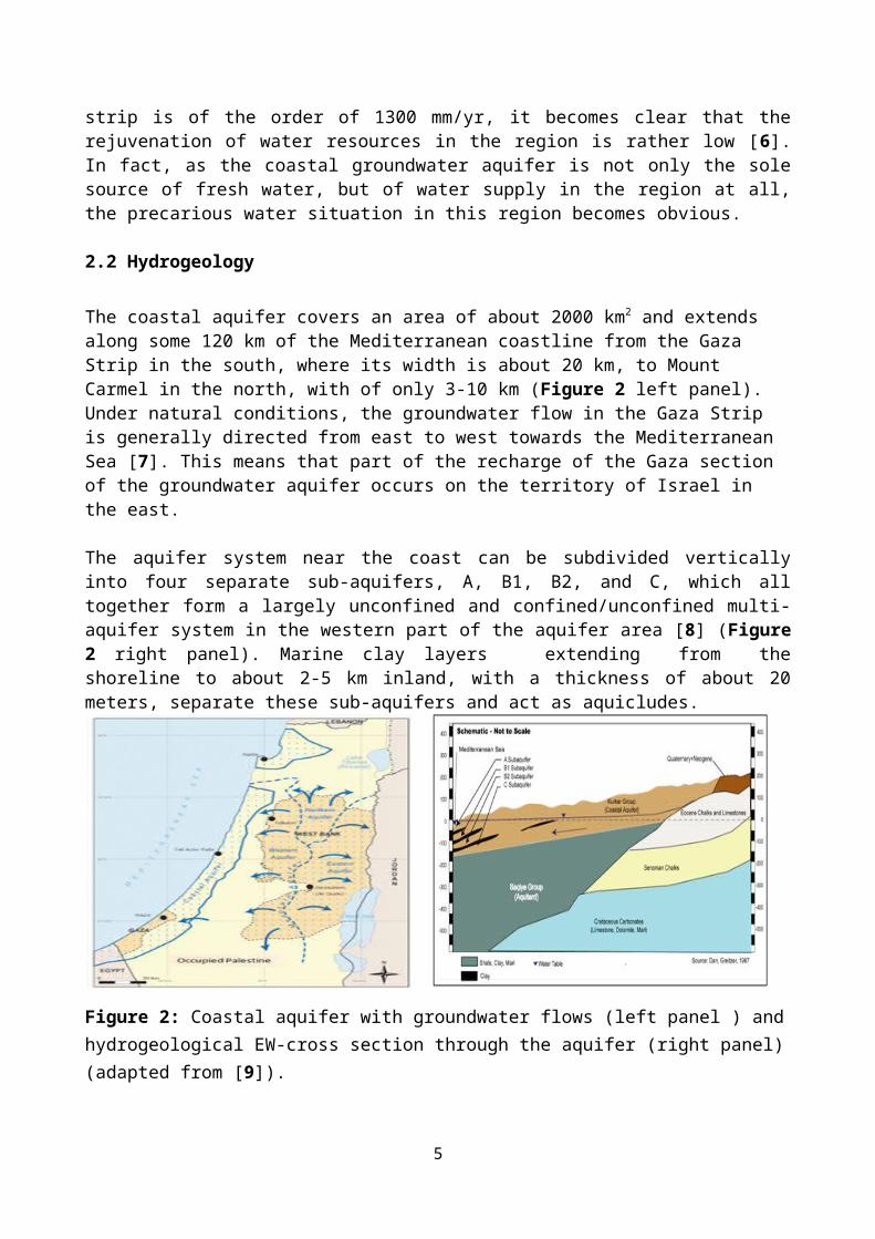
The coastal aquifer covers an area of about 2000 km2 and extends along some 120 km of the Mediterranean coastline from the Gaza Strip in the south, where its width is about 20 km, to Mount Carmel in the north, with of only 3-10 km (Figure 2 left panel). Under natural conditions, the groundwater flow in the Gaza Strip is generally directed from east to west towards the Mediterranean Sea [7]. This means that part of the recharge of the Gaza section of the groundwater aquifer occurs on the territory of Israel in the east.
The aquifer system near the coast can be subdivided vertically into four separate sub-aquifers, A, B1, B2, and C, which all together form a largely unconfined and confined/unconfined multi-aquifer system in the western part of the aquifer area [8] (Figure 2 right panel). Marine clay layers extending from the shoreline to about 2-5 km inland, with a thickness of about 20 meters, separate these sub-aquifers and act as aquicludes.
3
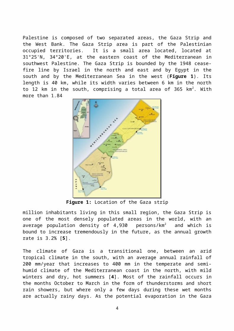
Figure 2: Coastal aquifer with groundwater flows (left panel ) and hydrogeological EW-cross section through the aquifer (right panel) (adapted from [9]).
3. MATERIAL AND METHODS
3.1 SEAWAT-2000 variable-density groundwater flow and solute transport model
The regional scale variable-density model SEAWAT-2000[10] which simulates coupled groundwater flow and solute transport is employed in the present study. One particular advantage of this model is that it is essentially an extension of the well-known MODFLOW- groundwater flow model [11]. This means (see below) that the SEAWAT- conceptual model set-up can, to a large extent, also be based on a previous MODFLOW- set-up.
3.2 Governing equations
The density-dependent groundwater flow equation Using the concept of the equivalent total freshwater head, the groundwater flow equation for variable density flow can be written in terms of this fresh water head, as follows [10]:
∂∂ x [ ρ k fx {∂ hf
∂ x }]+ ∂∂ y [ ρ k fy {∂ hf
∂ y }]+ ∂∂ z [ ρ k fz {∂ h f
∂ z+( ρ−ρ f
ρf) ∂ Z
∂ z }]¿ ρ S f
∂ hf
∂t+ϴ ∂ ρ
∂C∂C∂ t
−¿ρsqs(1)
where:hf, equivalent fresh water head [L].kfx, kfy, kfz, equivalent freshwater hydraulic conductivities in the three coordinate directions [LT-1].ρ, density of native aquifer water [M/L3]ρf, density of freshwater [M/L3].Sf, specific storage in term of equivalent fresh water head [L-1].C, solute concentration [M/ L3].ϴ, effective porosity (dimensionless).
4
ρs, density of water entering from a source or leaving through a sink [M/L3]. qs, volumetric flow rate of sources or sinks per unit volume of aquifer [T-1].
The solute transport equation
The solute transport equation holds for both variable- and constant-density flow and transport [12]:.
∂C∂ t
=∇ . ( D .∇C )−∇ . (vC )−qs
ϴC s+∑
k=1
n
Rk (2)
where;
C, salt concentration [ML-3].D, hydrodynamic dispersion coefficient [L2/T].v, fluid velocity [L/T] qs, flux of source or sink (T-1).Cs, solute concentration of water entering from sources or sinks [M/ L3].ϴ effective porosity (dimensionless).Rk, rate of solute production or decay in reaction k of n different reactions [M/(L3
*T)], which in the present application of pure saltwater transport is set to zero.D, hydrodynamic dispersion tensor, defined as D = Dm + D*, where Dm and D* are the coefficients of mechanical and molecular dispersion, respectively [L2/T].
3.3 SEAWAT model set-up for the Gaza coastal aquifer
3.3.1 Conceptual model of the Gaza aquifer
The major features of the 3D- conceptual model for groundwater flow and transport in the Gaza aquifer for implementation into SEAWAT are illustrated in Figure 3. Basically, as the major structural features of the groundwater flow model part of SEAWAT, including the head/flow- boundary conditions (BC) (see below) are essentially identical to that of the MODFLOW-model, the conceptual model setup of SEAWAT for the Gaza coastal aquifer, as implemented in Visual MODFLOW, relies directly also on that of the original MODFLOW groundwater flow model set-up [13]. This means also that the calibration results of the constant-density MODFLOW-2000 model, as well as the main internal and external hydrologic sources and stresses, which are discussed in detail in [14,15], will be incorporated with only minor adjustments into the SEAWAT-2000 variable-density model, to simulate the transient dynamics of the saltwater-freshwater interface in the Gaza coastal aquifer.
3.3.2 Boundary and initial conditions
In addition to the BC’s of the flow model, which are indicated in Figure 3, i.e. constant head (Dirichlet BC) (h0=0m) at the coastal boundary, Neumann BC’s of no-flow at the northern and southern borders of the domain, and inflow-BC’s at the eastern Gaza-Israeli border, wherefore the latter are adjusted during the calibration of the model.
Regarding the concentration boundary conditions for the solution of the solute transport equation in SEAWAT, these are, namely, (1) a Dirichlet BC with a constant salt (TDS) concentration of that of seawater, i.e. C=C0 = 35,000 mg/l (salinity) is set in all layers for all cells along the Gaza coastline and, (2) a Neumann (flux) BC [see 10, for details], with a TDS between 250-1100 mg/l (salinity) in the inflow is assigned in all layers for all cells at the eastern (Gaza-Israeli) boundary.
5

On the other hand the salinization due to infiltrating contaminant water from surficial recharge (rainfall) is considered to be negligible.
Figure 3: Schematization of the conceptual model of the Gaza coastal aquifer [13, 14].
For the transient variable-density groundwater flow and solute transport simulations, which cover a time period of 2001-2010, initial conditions for chloride concentrations distributed across the model area must be set. In the present application the simulated chloride concentrations for year 2000, as obtained during the steady-state calibration of the model, are assigned as initial condition for the transient simulation.
Moreover, the SEAWAT requires the concentration of total dissolved solids (TDS), which determines the density of the saline fluid and with it, through feedback the flow, rather than the chloride (Cl)- concentrations. Therefore, the latter are linearly converted to TDS, by assuming that seawater has a Cl- concentration of 19,800 mg/l and a TDS value of 35,000 mg/l [16]. This means, that the SEAWAT-computed concentrations are discussed in terms of total salinity, not Cl- concentrations.
3.4 Calibration of the SEAWAT- solute transport model
Following the usual approach in groundwater flow and transport modeling [17,18], both steady-state and transient calibrations for the solute transport module of SEAWAT, wherefore salinities measured biannually in the 2000-2010 time period at 51 wells distributed across the model area [see 13,14,15] are used as calibration targets, have been carried out. More exactly, as in the SEAWAT- model the TDS- salinity is required, prior to the use in the subsequent processing, all chloride concentrations are converted to equivalent TDS- salinity.
In addition to the aquifer parameters already calibrated in the groundwater flow model, namely, hydraulic conductivities/transmissivities and, for transient simulations, also the storage coefficients of the various aquifer layers [13, 14], the dispersivities for the sub-aquifers and aquitards (clay) layers are adjusted by trial and error in the transient calibration of the SEAWAT solute transport model.
The solute transport simulations show clearly the effects of the continuously ongoing overexploitation of the Gaza aquifer over the years on the seawater intrusion process. Thus Figure 4 shows a plain view of the simulated seawater intrusion in the sub-aquifer C of the Gaza aquifer for three years during 2000-2010. One may notice that most of the area affected by seawater intrusion is located in the north of the Gaza strip and in the south, near Khan-Younis city, as there
6

is a gradual inland invasion of seawater with time, where the zones of the pre-development interface are moving inland more and more.
(a) (b) (c)Figure 4: Simulated salinity distribution at the bottom of the aquifer for year 2000 (a), 2005 (b) and 2010 (c).
3.5 Numerical implementation of the various management scenarios
In line with the major objective of the present study, after successful calibration of the solute transport model, numerous management scenarios schemes are examined in this section that could be suitable to maintain the ground water system in the present state and to control the salinity distributions in the coastal aquifer area within the target period 2011-2040.
The first, model scenario, is basically a time-extension of the transient simulation carried out previously (see [13] for more details), but now up to year 2040, assuming that the groundwater abstraction rate from the aquifer will increase continuously during this time, to comply with the population growth and augmenting agricultural needs, and that no new water resources, other than natural rainfall infiltration, are available for aquifer recharge. This is the “do- nothing”-scenario.
The second group of scenarios comprise actually the “active” management scenarios. More specifically, three proposed variants or cases of artificial recharge systems that differ by the locations and extensions of the well fields where the treated wastewater will be injected as a source of artificial recharge to the aquifer (see Figure 5), have been implemented in SEAWAT.
In all three variants of the artificial recharge scenario group, the injection of the wastewater is assumed to start in 2015 and to continue until the end of the simulation period in 2040, with the
7

hope to achieve a quasi-stabilization of the groundwater heads at the minimum water level of 0 m above MSL by that time and, hopefully, also to revert or, at least, to control the seawater intrusion in the aquifer in the long run.
(a)80000 85000 90000 95000 100000 105000
75000
80000
85000
90000
95000
100000
105000
110000
0 5000 10000 15000
In jectio n w e lls
(b) (c)Figure 5: Locations of well-fields for 2nd -scenario of 1st - case (a), 2nd -case (b) and 3rd - case (c).
The particular feature of the first recharge variant /case (Figure 5a) is that the artificial recharge zones form two agglomerations or fields of injection wells, located more or less above the two large groundwater head depression cones, that have already been established in the south and north of the Gaza strip, respectively, to be at very critical levels [14,15].
In the second case of the second (recharge) scenario, the artificial recharge is implemented through a series of injection wells located upstream of the highly contaminated zone (salinity > 1000 mg/l TDS) and along the seawater intrusion front, parallel to the coastline.
In the third case of the second (recharge) scenario, the artificial recharge is based on the implementation of surface infiltration basins for wide-scale reuse of wastewaters as an aquifer recharge-recovery system, which could be given an additional treatment by soil aquifer treatment (SAT) or geo-purification of the wastewater effluent. The proposed infiltration basins are planned to be constructed far away from the sea shore, i.e. adjacent to the proposed wastewater treatment plants in the north and the middle zones and close to the eastern border between Gaza and Israel.
4. RESULTS AND DISCUSSION
The results of the SEAWAT-simulations with the four (one do-nothing and three recharge variants) future groundwater management scenarios for the Gaza coastal aquifer are shown for the target year 2040 in Figures 6, 7 and 8. Thus one may notice clearly that the first (do-nothing) scenario will lead to ongoing negative impacts on the aquifer, since the regional groundwater levels will continue to decline in the coming thirty years (Figure 6a), the amount of saltwater intrusion into the coastal part of the aquifer increases by about 35 %, and the salinity will be increased by 34 % (Figure 7a).
In contrast, all three artificial recharge cases of the second scenario group are more or less able to forestall, or even to remedy, the presently existing adverse aquifer conditions, namely, low groundwater heads and high salinity by the end of the target simulation period, year 2040, as shown in the other three panels of Figures 6 and 7. The positive effects of this second (recharge) scenario
8
group become even more striking, when compared with the first (do-nothing) management scenario, which is the most critical one, as it assumes ever-increasing groundwater extraction in the coming 30 years.
(a)
(b)
(c) (d)
Figure 6: Year-2040 head for 1st scenario (a), compared with 2nd scenario of 1st case (b), 2nd case (c) and 3rd case (d).
9

(a) (b) (c) (d)
Figure 7: Year-2040 salinity for 1st scenario (a), compared with 2nd scenario of 1st case (b), 2nd case (c) and 3rd case (d).
Figure 8: Percentile changes of amount of the seawater intrusion (left panel) and salinity (right panel) under the various (four) management schemes.
From the water budget point of view, compared with the first (do-nothing) scenario, the additional fresh water infiltrating into the aquifer by the artificial recharge, reduces the amount of water entering the aquifer by seawater intrusion at the end of the target period in 2040 by 81%, 77% and 72%, for the three recharge cases, respectively (Figure 8), while reducing, at the same time, the saltwater pollution (salinity) in the Gaza aquifer by 15%, 32% and 26%, respectively.
5. CONCLUSIONS
The ongoing depletion of the coastal aquifer in the Gaza strip, due to overexploitation and, possibly also by negative impacts as a result to climate change, has led to a significant decline of the groundwater levels, excessive reductions in yields, and many groundwater wells even going dry over the last two decades. For this reason, some of these wells had already to be shut down in recent years, as their measured groundwater salinities exceeded the WHO- 250 mg/l drinking standard limit. This significant deterioration of the groundwater quality all across the Gaza strip indicates that salt water intrusion from the Mediterranean Sea, accelerated by the decline of the groundwater levels, has become an imminent problem there.
In light of these imminent groundwater problems in the Gaza aquifer, long-term remediative solutions are asked for. One way to this, is the application of appropriate integrated groundwater management strategies for this aquifer, in order to maintain its sustainability and to forestall future problems. The investigation of the applicability and feasibility of such management strategies can only be effectuated properly by numerical groundwater flow and transport modeling.
This paper has outlined the development of a numerical solute transport model for simulating of groundwater and salinity distributions in the Gaza coastal aquifer. To that avail, in the first part the 3D- finite difference, coupled groundwater flow and contaminant transport model MODFLOW/MT3D/SEAWAT, as embedded in the VISUAL MODFLOW software environment, has been applied to study and to simulate groundwater and salinity distributions in the Gaza coastal aquifer within the target period 2000-2010, using physically based hydrologic and meteorological parameters, as well as the anthropic impacts on the groundwater conditions.
10

In the final part of this paper the SEAWAT-model has been used as a predictive management tool to simulate the future evolution of groundwater and salinity in the Gaza aquifer for the next 30 years. More specifically, the effects of different integrated water resources management scenarios within the target period 2011-2040, including also options of artificial groundwater recharge, which is considered an effective means to increase groundwater levels again and to reduce aquifer salinity in the long-run, are assessed numerically.
The results obtained with the first (worst or do-nothing) management scenario indicate that, without any further action, by year 2040, there will ongoing negative impacts on the aquifer, with declines on the regional groundwater levels in the coming thirty years, with particularly high and localized head depression cones in the north and south of the model area. Meanwhile, saltwater that has already invaded large sections of the inland freshwater zone along the Gaza coast up to date, will have encroached even further inlands , especially in the named two depression zones. In contrast, the results of all three cases of the second (artificial recharge) scenario group provide evidence for some efficacy of this management approach, in general, to guarantee the sustainability of the Gaza coastal aquifer in the long run, until the end of the target year, 2040. Moreover, there is some success in aquifer recovery that may forestall or remedy the adverse aquifer conditions, such that the presently existing saltwater intrusion-interface will be partly reverted by year 2040.
The results obtained from the simulated three cases of the second (artificial recharge) scenario group can promote and guide the Palestinian Water Authority (PWA) for taking further decisions on the adoption of a long-term strategic plan of artificial recharge to control the future seawater intrusion in the Gaza coastal aquifer and so to secure – at least to a certain extent - the long-term groundwater resources in this region.
6. REFERENCES
[1] PWA, 2010a. Agricultural and Municipal Water Demand in Gaza Governorates. Strategic Planning Directorate, Palestinian Water Authority, Gaza, Palestine.
[2] H. Sirhan and H. Nigim, 2002. Evaluation of Wastewater Reclamation for Reuse in Agriculture in the Gaza Strip. International Water Association (IWA), Iraklion, Greece, 8, 428-445.
[3] Kh. Qahman and A. Larabi, 2005. Evaluation and numerical modeling of seawater intrusion in the Gaza aquifer (Palestine). Hydrogeology Journal, 14, 713–728.
[4] PWA, 2001. Hydrogeological report for the Gaza strip, Technical Report, Volume 2, Palestinian Water Authority (PWA), Gaza Strip, 67 p.
[5] PCBS, 2000. Population, housing and establishment census 1997. Palestinian National Authority, Palestinian Central Bureau of Statistics (PCBS), Ramallah, 19p.
[6] PWA/USAID, 2000. Summary of Palestinian Hydrologic Data 2000 – Volume 2: Gaza. Palestinian Water Authority (PWA), Palestine.
[7] A. Mercado, 1968. A hydrological survey of groundwater in the Gaza Strip, Tahal Report. Tel Aviv, Israel (in Hebrew).
11
[8] PEPA, 1996. Gaza environmental profile, Part one-inventory of resources, Palestinian Environmental Protection Authority (PEPA), Gaza, 1-21.
[9] PWA, 2003. "Groundwater Levels Decline Phenomena in Gaza Strip Final Report". Water Resources and Planning Department-Hydrology Section. Palestinian Water Authority, Gaza.
[10] C.D. Langevin, W.B. Shoemaker and W. Guo, 2003. MODFLOW-2000, the U.S. Geological Survey Modular Ground-Water Model–Documentation of the SEAWAT- 2000 Version with the Variable-Density Flow Process (VDF) and the Integrated MT3DMS Transport Process (IMT), Report U.S. Geological Survey, 03-426.
[11] M.G. McDonald and A.W. Harbaugh, 1983. A modular three-dimensional finite-difference ground-water flow model. Open-File Report 83-875. U.S. Geological Survey, Reston, VA.
[12] C. Zheng and G.D. Bennett, 1995. Applied contaminant transport modeling, theory and practice: Van Nostrand Reinhold, London, UK.
[13] H. Sirhan and M. Koch, 2013a. Numerical Modeling of the Effects of Artificial Recharge on Hydraulic Heads in Constant-Density Ground Water Flow to Manage the Gaza Coastal Aquifer, South Palestine, 6th International Conference on Water Resources and Environment Research, ICWRER 2013, Koblenz, Germany, June 3-7, 2013.
[14] H. Sirhan and M. Koch, 2013b. Numerical Modeling of three-dimensional Coupled Flow and Salinity Transport in the Gaza Coastal Aquifer, South Palestine , In: Proceedings of the "6th International Conference on Water Resources and Environment Research, ICWRER 2013, Koblenz, Germany, June 3-7, 2013.
[15] H. Sirhan, 2014. Numerical Feasibility Study for Treated Wastewater Recharge as a Tool to Iimpede Saltwater Intrusion in the Coastal Aquifer. PhD Thesis, Department of Geohydraulics and Engineering Hydrology, Kassel University, Germany, 262 pp.
[16] G.G. Parker, G.E. Ferguson and S.K. Love, 1955. Water resources of southeastern Florida: Geological Survey Water-Supply Paper, 1255, 965.
[17] M. Anderson, and W. Woessner, 1992. Applied groundwater modelling, simulation of flow and advective transport, Academic Press, Orlando, FL.
[18] N. Kresic, 1996. Hydrogeology and groundwater modeling, CRC Press, Boca Raton, FL.
12