Vegetation Fire and Smoke Pollution Warning and …€¦ · CONCEPT NOTE AND EXPERT RECOMMENDATIONS...
50
GAW Report No. 235 WEATHER CLIMATE WATER Vegetation Fire and Smoke Pollution Warning and Advisory System (VFSP-WAS): Concept Note and Expert Recommendations
Transcript of Vegetation Fire and Smoke Pollution Warning and …€¦ · CONCEPT NOTE AND EXPERT RECOMMENDATIONS...

GAW Report No. 235
WEA
THER
CLI
MAT
E W
ATER
Vegetation Fire and Smoke Pollution Warning and Advisory System (VFSP-WAS): Concept Note and Expert Recommendations


GAW Report No. 235
Vegetation Fire and Smoke Pollution Warning and Advisory System (VFSP-WAS): Concept Note and Expert Recommendations Authors: Johann Georg Goldammer, Stéphane Mangeon, Melita Keywood, Johannes W. Kaiser, William J. de Groot, Dodo Gunawan, Christopher Gan and Alexander Baklanov
GFMC

© World Meteorological Organization, 2017 The right of publication in print, electronic and any other form and in any language is reserved by WMO. Short extracts from WMO publications may be reproduced without authorization, provided that the complete source is clearly indicated. Editorial correspondence and requests to publish, reproduce or translate this publication in part or in whole should be addressed to: Chairperson, Publications Board World Meteorological Organization (WMO) 7 bis, avenue de la Paix Tel.: +41 (0) 22 730 84 03 P.O. Box 2300 Fax: +41 (0) 22 730 80 40 CH-1211 Geneva 2, Switzerland E-mail: [email protected] NOTE The designations employed in WMO publications and the presentation of material in this publication do not imply the expression of any opinion whatsoever on the part of WMO concerning the legal status of any country, territory, city or area, or of its authorities, or concerning the delimitation of its frontiers or boundaries. The mention of specific companies or products does not imply that they are endorsed or recommended by WMO in preference to others of a similar nature which are not mentioned or advertised. The findings, interpretations and conclusions expressed in WMO publications with named authors are those of the authors alone and do not necessarily reflect those of WMO or its Members. This publication has been issued without formal editing.

TABLE OF CONTENTS
PREFACE 1. BACKGROUND: RATIONALE AND GOALS OF THE WORKSHOP ............................. 1 2. INTRODUCTION TO THE REGIONAL SITUATION IN SOUTH-EAST ASIA .............. 1 3. BACKGROUND: IMPACTS OF SMOKE FROM VEGETATION FIRES .......................... 3 Health ................................................................................................................ 3
Towards an integrated approach in fire management and vegetation fire smoke management ....................................................................................................... 3
Health impacts associated with fire emissions .......................................................... 3 Early warning systems .......................................................................................... 4 4. RECOMMENDATIONS FOR ESTABLISHING A VEGETATION FIRE AND SMOKE
POLLUTION WARNING AND ADVISORY SYSTEM (VFSP-WAS) ............................ 4 5. RECOMMENDATIONS FOR ESTABLISHING A REGIONAL FIRE AND SMOKE
POLLUTION WARNING AND ADVISORY CENTER (RVFSP-WAC) .......................... 7 Structure of a regional center in South-East Asia ...................................................... 9 Existing regional institutions and framework ............................................................ 9
Partnerships ........................................................................................................ 11
Context within WMO ............................................................................................. 11 6. TOPIC SPECIFIC RECOMMENDATIONS ............................................................... 12 Fire danger and seasonal forecast ........................................................................... 12 Fire emissions and haze forecast ............................................................................ 13 Observations and data production for verification and assimilation .............................. 15 Editorial note and terminology ............................................................................... 16 REFERENCES ................................................................................................................ 17 Annex 1 WMO EC-68 vision for the Seamless Data Processing and Forecasting System ..... 21 Annex 11a Designation procedure for RSMC and GDPFS centers ....................................... 23 Annex 11b Designation process of RSMC ASDF included in SDS-WAS Implementation Plan ... 24 Annex 111 Background on fires burning in peatland biomes and other organic terrain .......... 26 Annex IV Early Warning Systems ................................................................................ 27 Annex V Summary of further expert recommendations for the mission statements
and goals of a Regional Vegetation Fire and Smoke Pollution Warning and Advisory Center .................................................................................... 29
Annex VIa ASEAN Specialised Meteorological Centre (ASMC) ........................................... 30 Annex VIb ASEAN Regional Hazard Action Plan ............................................................... 31 Annex VIIa Workshop agenda ....................................................................................... 34 Annex VIIb List of workshop participants ........................................................................ 39


Preface This concept note expresses the expert recommendations resulting from discussions at the international workshop on ‘Forecasting Emissions from Vegetation Fires and their Impacts on Human Health and Security in South-East Asia’ which was hosted by the Indonesian Agency for Meteorology, Climatology and Geophysics (BMKG), Jakarta, from 29 August to 1 September 2016. The workshop was organized by the World Meteorological Organization (WMO) and the International Biomass Burning Initiative (IBBI) in collaboration with the United Nations International Strategy for Disaster Reduction/International Wildfire Preparedness Mechanism (UNISDR/IWPM), United Nations University (UNU), Global Wildland Fire Network (GWFN) through the Global Fire Monitoring Center (GFMC), Deutsche Gesellschaft fu ̈r Internationale Zusammenarbeit (GIZ) GmbH, and the International Global Atmospheric Chemistry (IGAC) Project (IGAC). Arising from the keen interest of regional WMO Members, the note provides guidance for addressing the issues of vegetation fire and smoke pollution. It also proposes the establishment of a Vegetation Fire and Smoke Pollution Warning and Advisory System (VFSP-WAS) and to support the potential foundation of regional centers, possibly Regional Specialized Meteorological Centers (RSMC) on the topic, i.e. a Regional Vegetation Fire and Smoke Pollution Warning and Advisory Center (RVFSP-WAC). Although most of the examples described here focus on the South-East Asian region, the concepts remain applicable to other regions (e.g. for Africa, Latin America, Northern Asia). “South-East Asia” as referred to in this note includes WMO Members from both Regional Associations II and V (Asia and South-West Pacific).


BACKGROUND: IMPACTS OF SMOKE FROM VEGETATION FIRES
1
1. BACKGROUND: RATIONALE AND GOALS OF THE WORKSHOP The scope of the international workshop “Forecasting Emissions from Vegetation Fires and their Impacts on Human Health and Security in South-East Asia” was to:
1. Provide an opportunity to share experience and knowledge between Southeast Asian and international scientists, representatives of national agencies and practitioners on the underlying reasons, meteorological, environmental and human health impacts of vegetation fires and smoke pollution.
2. Provide initial overview of the tools for forecasting and train personnel of responsible agencies in forecasting vegetation fire smoke emissions, transport, air quality and impact on human health.
3. Explore the interest and feasibility in setting up Regional Facilities that can assist WMO Members in the region in forecasting vegetation fire smoke emissions, its transport, pollution and impacts and to evaluate the capacity of coutries in the area in supporting/providing such facilities.
This Concept Note reports on the first themes (1 and 2) to supports the last theme (3). While the workshop provided an important opportunity to share experiences among different experts and institutions in the region, it also evaluated the requirements for improved services for fire smoke warning in the region, and how these requirements could be integrated in an operational context. However, the workshop did not tackle issues related to institutional aspects and to logistic elements. Should countries in a region consider the development of regional services as a priority, further discussions in an appropriate framework such as a corresponding WMO Regional Association meeting are required, formal WMO procedures should be followed (akin to the procedures established for the Sand and Dust Storms Warning and Advisory System (SDS-WAS), see Annex IIa). 2. INTRODUCTION TO THE REGIONAL SITUATION IN
SOUTH-EAST ASIA Since the 1990s, South-East Asia and neighbouring regions of Asia have been increasingly affected by excessive use of fire in the land use and land-use change and by recurrent human-cause wildfires. The use of fire has resulted in ecosystem degradation and environmental damage including extended smoke pollution affecting human health and the composition of the regional and global atmosphere (Field et al. 2009). In South-East Asia traditional slash-and-burn agriculture (swidden land cultivation) during the past millennia has provided livelihood for indigenous forest and rural communities, in many cases based on traditional principles of sustainability. However, since the beginning of the 20th Century population growth, migration and economic development has resulted in extended conversion of native forests and wetlands (peat biomes) to agricultural lands and plantations. The use of fire as the most economic tool for clearing native vegetation has become a driver of change in the region. Biodiversity- and carbon-rich pristine forest and peat-swamp ecosystems have been replaced by agro-industrial systems. The periodic recurrence of the El Niño-Southern Oscillation (ENSO) favours the

VEGETATION FIRE AND SMOKE POLLUTION WARNING AND ADVISORY SYSTEM (VFSP-WAS): CONCEPT NOTE AND EXPERT RECOMMENDATIONS
2
spread of land-use fires to uncontrolled wildfires, which has caused additional, non-intended loss of native ecosystems. During the El Niño droughts in 1982-83 fires affected more than 5 million hectares of land in the Indonesian province of East Kalimantan, Borneo. While these events remained largely unnoticed globally, during the early and late 1990s, particularly during the El Niño of 1997-98, the availability of satellite observation systems allowed the monitoring and damage assessment of large areas burned on insular South-East Asia, leaving behind more than 10 million hectares of fire-affected lands in Indonesia alone. Despite the scientific evidence for the negative environmental consequences of large-scale fire application and international assistance in building fire management capacities and offering advisory support for the development of environmental and land-use policies the situation remained largely unchanged (Goldammer 2006). With the onset of the next strong El Niño in 2015, the drought-supported acceleration of fire use resulted in the spread of fire on more than 2.6 million hectares. According to the World Bank the damages to the national economy caused by fires in 2015 amounted to Rp 221 trillion (US$16.5 billion), or around 1.9 percent of the country’s GDP, more than double what was spent on rebuilding Aceh after the 2004 tsunami (Glauber and Guanwan, 2016). Field et al. (2016) highlighted this was the second worst fire episode on record behind 1997. Apart from the economic damage and the intangible (or difficult to assess) losses of biodiversity and ecosystem services, the fires burning in September and October 2015 until the onset of the rainy season are estimated to have released about 11.3 Tg CO2 per day (Huijnen et al. 2016). For comparison: The daily release of CO2 from fossil fuel burning in the European Union Member States is 8.9 Tg. Recent reports about field measurements of peat fire emissions indicate that more in-depth research is required in order to obtain accurate emission factors that may differ from laboratory experiments (Putra et al. 2016). At the eve of the United Nations Climate Change Conference (COP 21) held in Paris, France, (30 November to 12 December 2015) the magnitude of emissions contributing to anthropogenic climate change alerted international fire scientists, managers and policy makers at the 6th International Wildland Fire Conference (Pyeongchang, Korea, October 2015) and called COP 21 for action:1 International policies and concerted action: Collective international efforts are needed to address impacts of vegetation fires that are of transboundary nature and currently affecting at an unacceptable level common global assets such as atmosphere and climate, natural and cultural heritage, and human health and security. Systematic application of principles of Integrated Fire Management (IFM), based on the wealth of traditional expertise and advanced fire science, contributes to sustainable land management, ecosystem stability and productivity, maintenance and increase of terrestrial carbon stocks, and reduction of unnecessary emissions of pollutants that affect human health and contribute to climate change. The COP 21 is encouraged to acknowledge the role and endorse the support of IFM as an accountable contribution to reduce greenhouse gas emissions, maintain or increase terrestrial carbon pools in all vegetation types and ensure ecosystem functioning.
1 Outcomes of the Conference: The Pyeongchang Declaration “Fire Management and Sustainable Development” and the annexed Conference Statement – http://www.fire.uni-freiburg.de/korea-2015.html

BACKGROUND: IMPACTS OF SMOKE FROM VEGETATION FIRES
3
3. BACKGROUND: IMPACTS OF SMOKE FROM VEGETATION FIRES Health The human or humanitarian dimension of burning for land-use change has been largely unnoticed in the international discussion. This refers particularly to the illness and premature deaths of smoke-affected populations. This problem had been addressed by the United Nations and partners in the aftermath of the 1997-98 fire smoke episode in South-East Asia by the publication of scientific data on the effects on human health and generation of the World Health Organization (WHO) Health Guidelines for Vegetation Fire Events (Schwela et al. 1999, Goh et al. 1999). However, in general limited attention has been paid by policy makers and the public to the consequences of vegetation fire smoke pollution on human health and security. A recent study reveals that more than 180,000 premature deaths per year globally are due to vegetation fire smoke pollution (Lelieveld et al. 2015). Towards an integrated approach in fire management and vegetation fire smoke management Integrated fire management includes social, economic, cultural and ecological evaluations for planning and operational systems in order to minimize the damage and maximize the benefits of fire. Identifying and mapping areas at risk of fires is crucial to integrated fire management in the region. This includes areas presenting significant fire risks and potential for generating transboundary haze pollution events. This mapping should be transparent and shared between all actors involved in the region. The nature of fires in South-East Asia, with large fire emissions and their impacts on population centers, requires an approach that integrates both fire and smoke management. Health impacts associated with fire emissions Vegetation fires release large amounts of particulate matter (PM) and toxic gases including carbon monoxide, nitrogen oxides, and non-methane organic compounds into the atmosphere. Large and frequent wildfires impact local and regional air quality and are a threat to human health (Bowman and Johnston 2005). Annually, around 340,000 premature deaths are estimated to be attributed to exposure from wildfire smoke (Johnston et al. 2012) while a recent study suggested that more than 180,000 premature deaths per year globally are due to vegetation fire smoke pollution (Lelieveld et al. 2015). Studies have clearly and consistently demonstrated that wildfire smoke PM is associated with respiratory (Henderson et al. 2011) and cardiovascular effects (Dennekamp et al. 2015) and that exposure to fire emissions represents the highest risk to vulnerable subsets of the population i.e. people with existing respiratory or cardiovascular illnesses, infants and the elderly (e.g. Statheropoulos et al. 2013). Health studies have primarily focused on PM so that the effects of other smoke components remain unclear, particularly effects with longer latencies (Reisen et al. 2015). A comprehensive approach in reducing the risk that emissions from vegetation fires pose to human health should include (Goh et al. 1999):

VEGETATION FIRE AND SMOKE POLLUTION WARNING AND ADVISORY SYSTEM (VFSP-WAS): CONCEPT NOTE AND EXPERT RECOMMENDATIONS
4
• Characterization of the magnitude and composition of the emissions and their transformations during transport.
• Quantification of resulting concentrations of ambient air pollutants in populated areas.
• Evaluation of likely exposure scenarios for affected populations (both indoors and outdoors).
• Assessment of consequent health risks posed by such human exposures. Satellite-derived products offer real-time fire observations, which provide information and data on active fires, burnt areas, and smoke emissions. Active fire observations are better at detecting flaming fires rather than low-temperature smouldering fires. Early Warning Systems Fire early warning systems are a key component to battling the increasing severity of future fire regimes under climate change (de Groot and Flannigan, 2014). Following the Third UNISDR International Conference on Early Warning (EWC III) and related consultations2, it was recommended that smoke early warning system used in the South-East Asia region and elsewhere would to be based on the Global Fire Early Warning System (Global Fire EWS) (de Groot and Goldammer 2013), which is complementary to the fire danger rating systems used by Indonesia, Malaysia, and the Association of Southeast Asian Nations (ASEAN) (de Groot et al. 2007). The foundation of the Global Fire EWS is the Canadian Forest Fire Weather Index (FWI) System, which is the most widely used fire danger rating system around the world (de Groot et al. 2015). Regional calibration of the FWI System has recently been updated for South-East Asia, and is in the process of being implemented in the Global Fire EWS. Investigations to further strengthen the calibration with new datasets are ongoing.3 For more details on the Fire Early Warning Systems see Annex IV. 4. RECOMMENDATIONS FOR ESTABLISHING A VEGETATION FIRE
AND SMOKE POLLUTION WARNING AND ADVISORY SYSTEM (VFSP-WAS)
The proposed warning and advisory system should build upon the experience acquired through comparable initiatives: the Copernicus Atmospheric Monitoring Services (CAMS), WMO Specialized Regional Meteorological Centres (e.g. ASMC in Singapore), the Sand-and Dust Storms Warning and Advisory System (SDS-WAS; e.g. its regional center in Barcelona), and the International Cooperation for Aerosol Prediction (ICAP). These demonstrated that small efforts can add significant value to the end-user by making use of existing products. The required efforts lie in the following areas:
1. Collecting the existing products and providing a centralized data access.
2. Calculating simple ensemble statistics, mostly generating a median product.
3. Performing a centralized verification (in near-real time if possible).
4. Creating accessible and comprehensive graphical products.
2 For the rationale and history of the Global Fire Early Warning System see http://www.fire.uni-freiburg.de/fwf/EWS.htm 3 See http://data.giss.nasa.gov/impacts/gfwed/

RECOMMENDATIONS FOR ESTABLISHING A VEGETATION FIRE AND SMOKE POLLUTION WARNING SYSTEM (VFSP-WAS)
5
5. Making the products available on a central web site. And more specifically for the purpose of fire and smoke:
6. Sharing fire products amongst the different producers, e.g. satellite observation products, emission inventories, on-site ground observations (including Global Atmosphere Watch (GAW) stations).
7. Taking boundary conditions for regional air composition models from global models (e.g. CAMS).
Points 1 to 5 could be applied to fire danger forecasting, current fire situation and smoke forecasting. The role of such a system should be to demonstrate added value and interpretation, as experience has shown that the mere collation and publishing of existing products would not in itself lead to optimal use by stakeholders. A Vegetation Fire and Smoke Pollution Warning and Advisory System (VFSP-WAS) would have a federation structure with regional nodes and involve a programme of research activities aimed at providing information needed to reduce uncertainty in the forecasting of impacts of smoke from vegetation fires, including:
1. The impact of peat burning on air quality. Research interests include detailed mapping of peatland areas, further studies of the emission factors and the composition of smoke from the combustion of peat are also required. Finally, the parametrisation of peat combustion in regional chemical transport models requires development. These methods could later be applied to other areas posing substantial fire emissions risk (e.g. deforestation areas).
2. Improvement in the timeliness of seasonal forecasts.
3. Improvement in the accuracy of longer-term forecasts (annual to decadal).
4. Detailed data-based information on fire danger and near-real-time information on the present situation.
5. Assimilation of near-real-time air quality observation data from GAW and other stations into smoke forecasting systems.
6. Generation of information products regarding smoke impacts that are user friendly and accessible. This would require harmonization of information from many diverse sources synchronised across applications, regions and disciplines. These products could include:
a. Detailed maps of seasonal forecasts of fire severity
b. Near-real-time maps of fire activity derived from new satellite information e.g. Himawari-8.
The VFSP-WAS is suggested as an international network of research, national operational centers and users organized through regional nodes assisted by VFSP-WAS regional centers (Figures 1-2). It will be coordinated by the VFSP-WAS Steering Committee. The VFSP-WAS would work as an international global hub of research, operational centers and end-users, organized through regional nodes (similar as it is realized for SDS-WAS, see SDS-WAS, 2015). At the level of regional nodes, VFSP-WAS can be structured as a federation of regional partners. A federated approach allows flexibility, growth and evolution, while preserving the autonomy of individual institutions. It involves a variety of participants (universities research organizations, meteorological services, emergency management bodies,

VEGETATION FIRE AND SMOKE POLLUTION WARNING AND ADVISORY SYSTEM (VFSP-WAS): CONCEPT NOTE AND EXPERT RECOMMENDATIONS
6
health organizations, etc.) gathered to cooperate and benefit without requiring changes to their own internal structures and existing arrangements.
Figure 1. Suggested structure of the Vegetation Fire and Smoke Pollution Warning
and Advisory System Further discussion on these topic areas is presented in the Topic-specific Recommendations section, later in this concept note.
Figure 2. Overview of a potential Vegetation Fire and Smoke Pollution Warning
and Advisory System

RECOMMENDATIONS FOR ESTABLISHING A REGIONAL FIRE AND SMOKE POLLUTION WARNING AND ADVISORY CENTER (RVFSP-WAC)
7
5. RECOMMENDATIONS FOR ESTABLISHING A REGIONAL FIRE AND SMOKE POLLUTION WARNING AND ADVISORY CENTER (RVFSP-WAC)
At the regional level, VFSP-WAS can be organized as a federation of regional partners and realized through regional activity Nodes and Regional Vegetation Fire and Smoke Pollution Warning and Advisory Centers (RVFSP-WAC). The organization of regional nodes research and forecasting activities within each node can be defined and led by a VFSP-WAS Regional Steering Group (RSG) and coordinated by a Regional Center. Schematic structure of such a Regional Fire and Smoke Pollution Warning and Advisory Center (RVFSP-WAC) is presented in Figure 3.
Figure 3. Schematic structure of a WMO Regional Node and Fire and Smoke Pollution
Warning and Advisory Center (RVFSP-WAC) The approach to establish a VFSP-WAS for a specific region would require existing providers to collaborate with one central unit hosting the VFSP-WAS – the Regional Vegetation Fire and Smoke Pollution Warning and Advisory Center (RVFSP-WAC) – in which several people would be dedicated to collecting, analysing and publishing the products with producers of the primary information being adequately acknowledged. A common verification system would provide credibility and be a key to facilitating further research and continued improvements of operational systems. Such a set-up would facilitate acknowledgements of product producers and allow linkages with existing regional activities in a flexible way. The strength of such a center would be to produce an ensemble forecast based on the already available products, e.g. by ASMC and NHMSs in the Southeast Asian region as well as partners outside the region willing to contribute to the center. Lateral and surface boundary conditions for regional forecasts could be provided by external partners with advanced capabilities (for instance, CAMS).

VEGETATION FIRE AND SMOKE POLLUTION WARNING AND ADVISORY SYSTEM (VFSP-WAS): CONCEPT NOTE AND EXPERT RECOMMENDATIONS
8
An RVFSP-WAC for South-East Asia could provide information in support of fire and emergency management. Because of the disastrous impact of fire and smoke pollution in the region, providing much-needed data input for activities that improve health and in particular air-pollution related health should form a cornerstone of the center’s mission and a focus of its products and services. However, the RVFSP-WAC would not itself lead on policy advice but instead contribute to collaborating entities. Mapping the potential partners interested in RVFSP-WAC should occur first and foremost, followed by the organization of a dialogue with these parties. This could occur through the organization of a stakeholder roundtable, or a workshop. This step should be inclusive of all actors from the global, to the regional, national and local level (cf. Partnerships section). In particular, various stakeholders and beneficiaries ought to be consulted: Meteorology, land (including peatland) and forestry management, fire management and firefighters, and health management and health practitioners. Understanding user needs is key to determine the type and quality of products and services required. This process would also be key to finalizing a statement of the goals an RVFSP-WAC would achieve (workshop experts’ recommendations for such mission statements are included in Annex V). Once a set of user-focused and impact-based products and services has been identified, as well as the accuracy needed for their operational use, the implementation plan should follow comprehensive steps from initial research and validation efforts to impact-based services (Figure 4). Any implementation plan for an RVFSP-WAC should contain a more informed and detailed sequence of steps leading to operational use. A stage implies a focus in the center development, however once the focus has changed, activity should be maintained on previous stages: for instance, training and capacity-building should be a core mission of the center, even once operational services are functional.
Figure 4. A conceptual series of steps to the implementation of a Regional Vegetation Fire and Smoke Pollution Warning and Advisory Center. Once a step is completed,
attention should be maintained on the preceding ones to ensure sustained improvement and applicability.
RECOMMENDATIONS FOR ESTABLISHING A REGIONAL FIRE AND SMOKE POLLUTION WARNING AND ADVISORY CENTER (RVFSP-WAC)
9
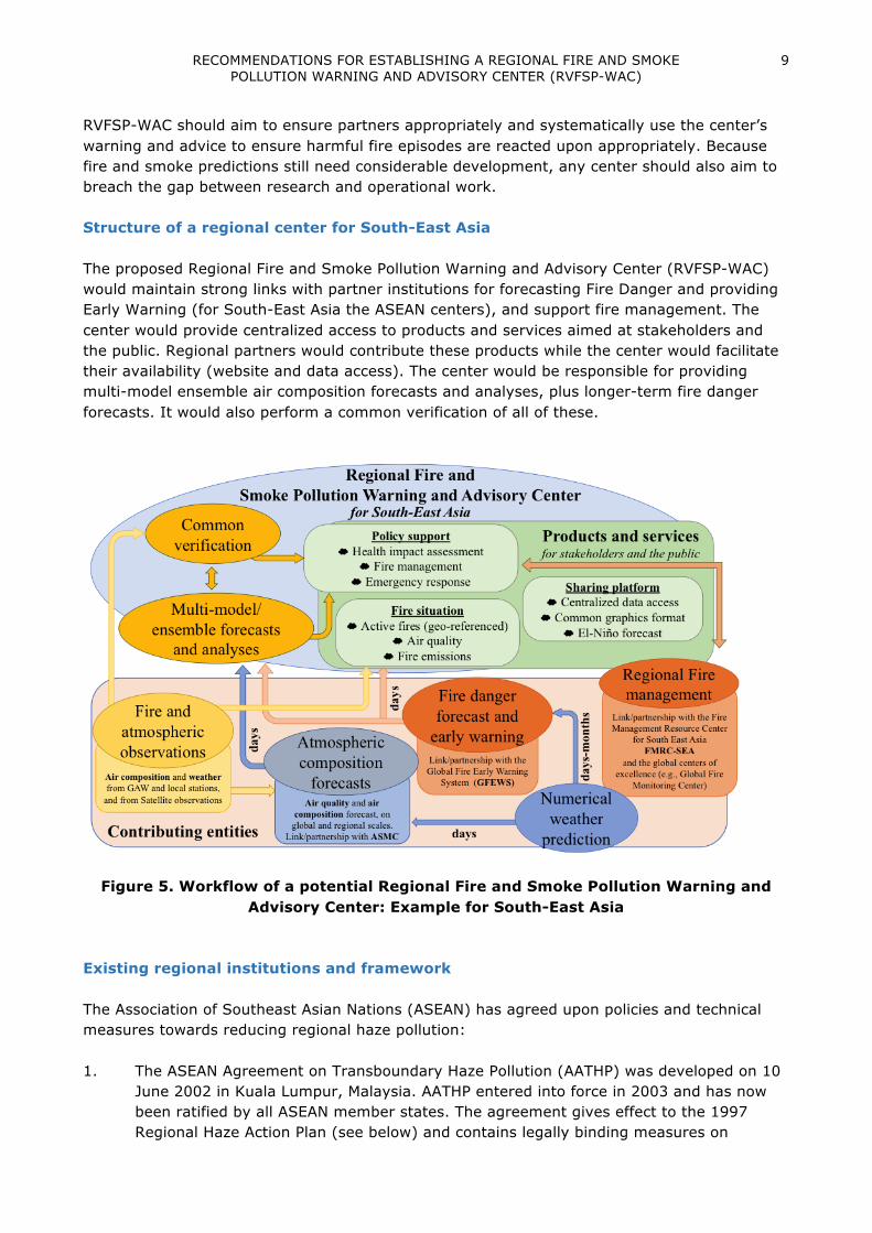
RVFSP-WAC should aim to ensure partners appropriately and systematically use the center’s warning and advice to ensure harmful fire episodes are reacted upon appropriately. Because fire and smoke predictions still need considerable development, any center should also aim to breach the gap between research and operational work. Structure of a regional center for South-East Asia The proposed Regional Fire and Smoke Pollution Warning and Advisory Center (RVFSP-WAC) would maintain strong links with partner institutions for forecasting Fire Danger and providing Early Warning (for South-East Asia the ASEAN centers), and support fire management. The center would provide centralized access to products and services aimed at stakeholders and the public. Regional partners would contribute these products while the center would facilitate their availability (website and data access). The center would be responsible for providing multi-model ensemble air composition forecasts and analyses, plus longer-term fire danger forecasts. It would also perform a common verification of all of these.
Figure 5. Workflow of a potential Regional Fire and Smoke Pollution Warning and Advisory Center: Example for South-East Asia
Existing regional institutions and framework The Association of Southeast Asian Nations (ASEAN) has agreed upon policies and technical measures towards reducing regional haze pollution: 1. The ASEAN Agreement on Transboundary Haze Pollution (AATHP) was developed on 10
June 2002 in Kuala Lumpur, Malaysia. AATHP entered into force in 2003 and has now been ratified by all ASEAN member states. The agreement gives effect to the 1997 Regional Haze Action Plan (see below) and contains legally binding measures on

VEGETATION FIRE AND SMOKE POLLUTION WARNING AND ADVISORY SYSTEM (VFSP-WAS): CONCEPT NOTE AND EXPERT RECOMMENDATIONS
10
monitoring and assessment, prevention, preparedness, national and joint emergency response, procedures for deployment of people, material and equipment across borders, as well as technical cooperation and scientific research.
2. The ASEAN Regional Haze Action Plan (Annex VIb) was endorsed and implemented in 1997 by the ASEAN Ministers of the Environment. Under the section “Regional Monitoring Mechanisms”, the plan strengthens the role of the ASEAN Specialised Meteorological Centre (ASMC)4, hosted under the Meteorological Service Singapore, in the monitoring and assessment of vegetation fires and the occurrence of transboundary smoke haze, as well as to conduct seasonal and climatological predictions, for the ASEAN region. These assessments feed into a larger network of actions taken at ground level and policy level by Governments in ASEAN. The Fire Danger Rating System (FDRS)5 for South-East Asia was also developed as part of this action plan and is produced by the Malaysian Meteorological Services (MetMalaysia).6
3. Within the framework of AATHP, the ASEAN Peatland Management Strategy (APMS), covering the period 2006-2020 was developed to guide member states to sustainably manage peatlands and reduce fires and associated haze. The strategy calls for an integrated fire management, where resources are focused on prevention.
As aforementioned, Indonesia (BMKG) also hosts the newly designated WIS-DCPC on ‘Transboundary Forest Fires’, which is closely linked with the GAW atmospheric pollution observations in the region. On a national level, with an increasing international recognition of the problem prior to and at COP 21, additional measures have been taken in Indonesia to enforce existing laws regulating the use of fire and to enhance governance in fire management at all levels. The responsibilities for fire management in Indonesia and neighbouring Southeast Asian countries are distributed between different agencies, notably the ministries for environment (Indonesia: Ministry for Environment and Forestry), specialized agencies such as those responsible for protected areas or the newly established Peat Restoration Agency (BRG) in Indonesia. In large wildfire situations or emergencies these agencies are supported by ministries responsible for emergency situations/disaster management and the military. Inter-agency coordination is critical for the success of strategic, long-term planning and implementation of fire management as an integral element of managing forests, protected areas, agricultural lands, plantations and other vegetation at wildfire risk (i.e. at landscape level), and addressing the excessive, illegal and inappropriate application of fire in land use and land-use change, the safe and benign use of fire, the prevention of and preparedness for wildfire situations. To facilitate the development of informed dialogue and building of institutional capacities and the participation of civil society (notably at local community level, NGOs, etc.) Regional Fire Management Resource Centers have been established in three regions of Europe and Central Asia and are planned for the Southeast Asian and (mainland) South Asian regions.
4 See: http://asmc.asean.org/home/ 5 FDRS was adapted from the Canadian Forest Fire Danger Rating System, see: http://haze.asean.org/fire-danger-rating-system-fdrs-for-southeast-asia-2/ 6 For more national and regional fire danger rating / early warning systems: See Early Warning Portal of the Global Early Warning System for Wildland Fire: http://www.fire.uni-freiburg.de/fwf/fwf.htm

RECOMMENDATIONS FOR ESTABLISHING A REGIONAL FIRE AND SMOKE POLLUTION WARNING AND ADVISORY CENTER (RVFSP-WAC)
11
Partnerships The proposed regional center would partner with the Regional Fire Management Resource Center – the Southeast Asia Region (RFMRC-SEA), which is has been established in Bogor, Indonesia, in March 2017 (official inauguration: July 2017). The RFMRC-SEA will serve as the 5th Regional Fire Management Resource Center.7 The RFMRCs are associated with the Global Fire Monitoring Center (GFMC)8 and the Global Wildland Fire Network (GWFN)9 (the first four regional centers have been established between 2010 and 2017 in South-East Europe10, Eastern Europe11, Central Asia12 and Eurasia/Russia13). These operate under the auspices of the United Nations International Strategy for Disaster Reduction (UNISDR) in fulfilment of the past “Hyogo Framework for Action 2005-2015: Building the Resilience of Nations and Communities to Disasters” and in the implementation of the voluntary follow-up “Sendai Framework for Disaster Risk Reduction 2015-2030”.14 In 2017, the 6th center will be established in South America (joint hosts: Brazil and Chile). To fully realize an effective regional service, the proposed system should acknowledge and complement existing formalized structures and agreements within ASEAN, to circumvent potentially contradictory warnings and assessments during periods of high risk. One mechanism is for WMO to work within the comprehensive Memorandum of Understanding between WMO and ASEAN (WMO-ASEAN MOU, 2002), which was signed by the two organizations’ Secretary-Generals in 2002. The MOU has provisions for deepening cooperation across ASEAN member states in mitigation of natural disasters and environmental monitoring. Another related mechanism is for the eventual system to flow its products and assessments into the ASMC, which under its ASEAN mandate is the official source of transboundary haze advice for its member states. This would enable the system to have maximum reach and not be primarily associated with one country. As a WMO center, the RVFSP-WAC would work in close collaboration with all WMO Members (NMHS) in the region and with the corresponding Regional Association (RA) (for South-East Asia, RA II and RA V). Workshop experts stressed the value of offering a user-friendly platform to disseminate products from partners could represent a significant part of any center’s responsibilities. This would provide users with a centralized database for regional products related to fire and smoke, including observations and predictions, and their history. Context within WMO During the 68th Executive Council (EC-68), WMO discussed the establishment of a regional center related to fire activities in two instances. First, in Agenda Item 5.2, a center for ‘Transboundary Forest Fires’ based in Jakarta (Indonesia) was designated as a WIS-DCPC (WMO Information System - Data Collection or Production Center). This center is to be further evaluated and supported in order to comply with the WIS manual before being endorsed by 7 Website under construction 8 http://www.fire.uni-freiburg.de/ 9 http://www.fire.uni-freiburg.de/GlobalNetworks/globalNet.html 10 http://www.rfmc.mk/ 11 http://nubip.edu.ua/en/reefmc 12 http://rcafmrc.num.edu.mn/ 13 Website under construction 14 http://www.unisdr.org/we/coordinate/sendai-framework

VEGETATION FIRE AND SMOKE POLLUTION WARNING AND ADVISORY SYSTEM (VFSP-WAS): CONCEPT NOTE AND EXPERT RECOMMENDATIONS
12
the Commission for Basic Systems (CBS). At the same time, it should be noted that data collections and dissemination on atmospheric composition is coordinated through the Global Atmosphere Watch (GAW) Programme, which has within its structure several data centers, that have also been designated as DCPCs. In addition, EC-68’s Agenda Item 8 would be relevant should the proposed center aim to constitute part of the seamless Global Data-Processing and Forecasting System (GDPFS). In particular Agenda Items 8.1 and 8.2 cover the implementation of seamless data processing and forecasting, and weather forecast including verification and high-resolution impact-based forecasting. The GDPFS aims to enable member states and partners to support decision-makers by providing impact-based forecasts and risk-based warnings, taking into account vulnerability and exposure information to support risk-based decision-making. A seamless GDPFS builds upon the original system that aims to be more agile and adaptable to support Application Programmes (e.g. AeM, AgMet, MMO, and PWS) and provides not only weather-related predictions, but also products that support impact-based forecasts and warnings, taking into account vulnerability and exposure information to support risk-based decision-making. The vision for a seamless GDPFS (endorsed by WMO during EC-68) is included in Annex I, and the single source of technical regulations of all operational data-processing and forecasting systems operated by WMO Members is the revised Manual on the GDPFS (WMO-No. 48515). The methodology and research needs for realization of the Seamless Prediction Systems have recently published in the WWOSC book: “Seamless Prediction of the Earth System: From Minutes to Months”16. Further WMO-relevant information is included in Annex II, listing the steps which were undertaken by the SDS-WAS nodes to be recognized as Regional Specialized Meteorological Centers (RSMC) with a global coordination by the SDS-WAS Steering Committee. Similar procedures may be used for the establishment of the regional centers related to fire activities. Note that there is at the moment no WMO global coordination of the warning and advisory system for fire and smoke pollution with such regional centers equivalent to SDS-WAS. However, the ASEAN Specialised Meteorological Centre (ASMC, asmc.asean.org, see Annex VIa) can be used an initial prototype for other vegetation fires and smog pollution centers, but with extended responsibilities and closer integrations with atmospheric composition observations of the WMO Global Atmosphere Watch (see the following recommendations and suggested schemes). 6. TOPIC-SPECIFIC RECOMMENDATIONS Fire danger and seasonal forecast There are already at the global and regional level a variety of fire danger indices. In the case of South-East Asia, the workshop highlighted the existence of operational products providing up-to seven days forecast of fire danger. These were the Indonesian Fire Danger Rating System, the ASEAN Fire Danger Rating System (developed and produced by Met Malaysia) and the Global Fire Early Warning System. All three are regionally calibrated developments of the Canadian Fire Danger Rating System, within this system regional fires are efficiently captured by the Drought Code (DC), whose inputs are simply temperature and precipitation. Evidence
15 http://www.wmo.int/pages/prog/www/DPFS/Manual/GDPFS-Manual.html 16 http://library.wmo.int/opac/index.php?lvl=notice_display&id=17276#.VZ6N5mPTDWG

TOPIC SPECIFIC RECOMMENDATIONS
13
suggests the key influence to regional temperature and precipitation (the El-Niño Southern Oscillation, ENSO) can be reasonably captured a couple of months ahead, although further research and development is needed for operational use of seasonal forecast (Spessa et al. 2015). A regional center could facilitate the coordination and development of sub-seasonal to seasonal predictions of fire severity in the area, a topic relevant to the World Weather Research Programme’s (WWRP) Sub-seasonal to Seasonal project (S2S). Research and development needs There is a research need to correlate fire danger parameters (i.e. Drought Code for peat fires, and Fine Fuel Moisture Code for active fires) with smoke pollution parameters (visibility, PM), and then to model regional transport to provide health warnings. The Bluesky Modelling Framework is a possible approach and has demonstrated application in North America. To use Bluesky, source strength of carbon emissions (and PM) from fires needs to be determined via research. Such research would most likely use a method to predict carbon emissions from peat moisture data or a surrogate, and from seasonal land burning (surface fires) based on area burned and fuel load data. Carbon and PM emissions could be modelled through historical fire, weather, and fuel data analysis, field experimentation, or in the case of peat fires specifically, could be obtained through correlation with peat moisture estimated using EO and fire danger data. Research and development is also required for long-term fire preparedness through seasonal and climatological predictions. Currently, it is possible to predict regional droughts 2-3 months ahead during ENSO. However, discussions during the workshop indicated this lead time might not be enough for long-term land management (and peatland restauration). Further, seasonal forecast would need to provide regional maps in order to emphasize the risks and usefulness to local actors (including agencies, civil society and people). The apparent predictability of fire and drought occurrences in the region remains encouraging. Fire emissions and haze forecast Reasonably fast and comprehensive estimates of smoke constituent emissions are derived from satellite observations of fires. There are three fundamentally different approaches: Fire Radiative Power The thermal radiation of a fire can be observed in real time in the middle infra-red (MIR) spectral range. Such observations are called “active fire” observations. If a quantitative signal is recorded, then it can be interpreted as “fire radiative power” (FRP) product. FRP has been shown to be proportional to the biomass combustion rate under certain conditions. Subsequently, instantaneous emission rates of various smoke constituents can be calculated with published emission factors. The advantages of this approach are the immediate availability of the observations and emission estimates even while the fires are still burning and the relatively weak dependence on the fire type for above-ground burning. Also, a quantitative characterization of the fires with a spatial resolution to 375 m (e.g. with NPP-VIIRS) and a temporal resolution 10 minutes (e.g. from Himawari-8) is possible when all available satellite data are used. Smoke detection Smoke plume can be readily detected in the atmosphere using remote sensing tools. Aerosol optical depth and carbon monoxide are relatively well observed by satellites, and are used to

VEGETATION FIRE AND SMOKE POLLUTION WARNING AND ADVISORY SYSTEM (VFSP-WAS): CONCEPT NOTE AND EXPERT RECOMMENDATIONS
14
infer fire emissions with “inversion” methods. While the atmospheric effect is relatively directly constrained for the observed species and the effect of any unobserved fire is also included, this methodology cannot distinguish fire from other sources (e.g. urban emissions) and has limited temporal and spatial resolution. Burnt area The detection and quantification of burnt area using satellite products is well established. Scaling burnt area with fuel load and combustion completeness yields burnt biomass, from which smoke emission can be calculated as in the FRP-based method described above.. In addition to being a commonly used method, the similarity to in situ methods employed locally by foresters on the ground means that significant validation and calibration has been carried out. In addition, since burnt area is persistent, burnt area can be detected even after an observation gap, due to cloud cover for example. The spatial resolution is also relatively high (down to 250 m for global coverage). However, since burnt area can only be observed after a burn has occurred it is not suitable for true real-time applications. Active fire satellite observation that can only distinguish between “fire” and “no fire”, e.g. due to its MIR channel saturating, produce binary “high-temperature event” (HTE) products. Sometimes, relatively simple assumptions are used to estimate burnt area from such products and emissions can subsequently be calculated as above. This approach is being used to correct for missing small fires in GFED (Randerson et al. 2012) or to calculate emissions in real time, e.g. with FINN (Fire Inventory from NCAR Wiedinmyer et al. 2011). These emission estimates are a key input to air composition and transport models, the main tool used for haze and air pollution forecasts. A RVFSP-WAC could coordinate multi-model ensemble forecasts of air pollutants through transport using regional expertise and capacities (NMHS). To support this, WMO Members outside the region informally suggested during the workshop the possibility of contributing to such a multi-model ensemble forecast and analysis (probably through lower resolution global aerosol models). Within the International Global Atmospheric Chemistry (IGAC) project, there is at present about half a dozen advanced global aerosol models that include emissions from vegetation fires and could be included in a multi-model ensemble forecast. Only half of the IGAC-participating models are now operational, the others remaining in a research and development stage (for some, only the vegetation fire component is not operational). Several real-time smoke forecasting products exist. The most established global aerosol forecasts are represented in the International Cooperative in Aerosol Prediction (ICAP). Four models include dedicated smoke treatment: CAMS (ECMWF and partners), MASINGAR (MRI-JMA), GEOS-5 (NASA), NAAPS (US Navy), where the first two use emissions from GFAS, the second from a similar FRP-based inventory (QFED), and the last from the active fires detected by the FLAMBE system. The ICAP initiative itself has demonstrated that simply collecting different forecasts in a single database and generating web pages with common plotting conventions is an effective tool for the developers to assess and improve their forecasting systems. EU’s Copernicus Atmosphere Monitoring Service (CAMS, http://atmosphere.copernicus.eu) is using its global atmospheric composition forecasts and GFAS fire emissions as common boundary conditions for an ensemble of seven operational regional air quality forecasting systems for Europe, including smoke (Marecal et al. 2015). A common real-time verification

TOPIC SPECIFIC RECOMMENDATIONS
15
with station data greatly helps the interpretation and further developments of the individual models and the median of all models has been shown to benefit from the individual strengths of the seven models and this statistical “analysis” is thus more accurate than any single forecast. ASMC provides operational and regularly updated information and products on the weather and smoke haze situation in the ASEAN region at http://asmc.asean.org (see Annex VIa). By using the fire distribution from CAMS-GFAS, it is already similar to a member in the CAMS ensemble of European air quality models. Research and development needs Despite its application in other regions, the implementation of ensemble forecasts for transboundary haze events in South-East Asia still requires substantial development. Since all CAMS services are freely available, the CAMS concept of implementing an ensemble of forecasts with common boundary conditions, presentation and verification could relatively easily be applied to the smoke situation in South-East Asia with ASMC already providing the first operational, high-accuracy ensemble member. To estimate emissions, observation gaps may occur due to cloud cover or when satellite observations are not available, and the consistent merging of FRP from different satellites is still an open research topic. Furthermore, the signal from peat fires is relatively small and the proportionality to biomass burnt is less certain for these fires than for above-ground fires. Finally, the emission factors vary for individual fires so that estimates on a small scale have a limited accuracy. The CAMS-GFAS (Kaiser et al. 2012) inventory is a widely used (e.g. by ECMWF, NASA, JMA and ASMC) example of such an inventory. The uncertainties in emission estimates from smoke observations are still large due to variable and relatively poorly known optical properties of aerosols, the poorly characterized errors atmospheric chemistry and transport models, and noise in the satellite observations. A recent example of an inversion of Southeast Asian fire emissions is given in Huijnen et al. 2016. For burnt area products, uncertainties arise mostly when small fires remaining undetected in the burnt area observations and large uncertainties in the estimates of the variable input of available fuel load and combustion completeness. For peat fires in particular, the burn depth is not constrained with global observations. The best-known example is the GFED inventory (van der Werf et al. 2010). Observations and data production for verification and assimilation Atmospheric composition observations in WMO are coordinated through the GAW Programme. To support the assessment of fire impacts, measurements of the combustion species (aerosols, reactive and greenhouse gases) are needed. There are several stations in the Southeast Asian region that can support verifications of haze forecast, but their number is very limited and some existing stations do not share data timely. There is also a network of ground-based observations, including Global Atmosphere Watch stations and other networks (e.g. Aeronet) in the region. An RVFSP-WAC would help member states utilize measurements of ambient air pollutants (including for South-East Asia the GAW stations at Bukit Koto Tabang, Sorong and Danum

VEGETATION FIRE AND SMOKE POLLUTION WARNING AND ADVISORY SYSTEM (VFSP-WAS): CONCEPT NOTE AND EXPERT RECOMMENDATIONS
16
Valley). Such a center could provide centralized data access to a variety of observations, from satellite observations to ground observations of fire and smoke. Although it would not necessarily be involved in producing data itself, it should encourage the regional use and dissemination of these observations. Fire observations are also available from an extensive fleet of operational and research satellites which can measure active fires, burnt area and (with less accuracy) smoke plumes and composition. Research and development needs Beyond a regional increase in number and coverage of observations, near-real-time access to site-observation data for assimilation and verification was stressed during the workshop as key to the improvement of chemical transport model. Some gaps in observations can be filled by the Acid Deposition Monitoring Network in East Asia (EANET) monitoring sites. However, EANET is not a contributing network to WMO GAW at this stage and even if it was, remaining data gaps may have to be filled by suitably placed new stations. Other satellite measurements can be used for data assimilation although this would require significant regional verification, research, and model development (e.g. Aerosol Optical Depth, Ozone, Carbon Monoxide). Editorial Note: Terminology This concept note includes terms that are widely used in fire ecology as well as in scientific disciplines and related technologies, such as atmospheric sciences, satellite remote sensing or early warning. The term “vegetation fire” is increasingly replacing the terms “wildland fire” (which is less understood outside of the English-speaking fire management community), “forest fire” (which is representing only one of many vegetation types), “land fire” (a term uniquely used in South-East Asia) or “wildfire” (which is an uncontrolled fire that could be started by lightning and any human cause or fire application). The term “peat fire” is clearly restricted to a specific type of organic terrain. Biomass burning is the general term that encompasses all of these terms and others (e.g. prescribed burning). For particular applications (management and scientific) it is important to specify which aspect of biomass burning is being addressed.

REFERENCES
17
REFERENCES
Bowman, D.M.J.S. and F.H. Johnston, 2005: Wildfire smoke, fire management, and human health, EcoHealth, 2(1), 76-80.
de Groot, W.J., B. Wardati and Y. Wang, 2005: Calibrating the Fine Fuel Moisture Code for grass ignition potential in Sumatra, Indonesia, International Journal of Wildland Fire 14: 161-168.
de Groot, W.J., R.D. Field, M.A. Brady, O. Roswintiarti and M. Mohamad 2007: Development of the Indonesian and Malaysian fire danger rating systems, Mitigation and Adaptation Strategies for Global Change 12(1): 165-180. DOI 10.1007/s11027-006-9043-8.
de Groot, W.J. and J.G. Goldammer, 2013: The Global Early Warning System for Wildland Fire. Pages 277-284 in Vegetation Fires and Global Change - Challenges for Concerted International Action, a White Paper directed to the United Nations and International Organizations, (J.G. Goldammer, ed., Global Fire Monitoring Center), Kessel Publishing House, Remagen-Oberwinter, Germany, ISBN: 978-3-941300-78-1
de Groot, W.J. and M.D. Flannigan, 2014: Climate change and early warning systems for wildland fire. Pages 127–151 in Reducing Disaster: Early Warning Systems for Climate Change (A. Singh and Z. Zommers, eds.) Springer, New York.
de Groot, W.J., B.M. Wotton and M.D. Flannigan, 2015: Wildland Fire Danger Rating and Early Warning Systems. Pages 207-228 in Wildfire Hazards, Risks and Disasters, (D. Paton, S. McCaffrey, F. Tedim, P. Buergelt, eds.) Elsevier, New York.
Dennekamp, M., L.D. Straney, B. Erbas, M.J. Abramson, M. Keywood, K. Smith, M.R. Sim, D.C. Glass, A. Del Monaco, A. Haikerwal and A.M. Tonkin, 2015: Forest Fire Smoke Exposures and Out-of-Hospital Cardiac Arrests in Melbourne, Australia: A Case-Crossover Study, Environmental Health Perspectives, 123(10), 959-964.
Field, R.D., Y. Wang, O. Roswintiarti and Guswanto, 2004: A drought-based predictor of recent haze events in western Indonesia, Atmospheric Environment, 38: 1869-1878
Field, R.D., G.R. van der Werf, and S.S.P. Shen, 2009: Human amplification of drought-induced biomass burning in Indonesia since 1960, Nature Geoscience, DOI: 10.1038/NGEO443
Field, R.D., G.R. van der Werf, T. Fanin, E.J. Fetzer, R. Fuller, H. Jethva, R. Levy, et al., 2016: “Indonesian Fire Activity and Smoke Pollution in 2015 Show Persistent Nonlinear Sensitivity to El Niño-Induced Drought.” Proceedings of the National Academy of Sciences 113, no. 33, 9204–9. doi:10.1073/pnas.1524888113.
Goh, K.T., D.H. Schwela, J.G. Goldammer and O. Simpson (eds.), 1999: Health guidelines for vegetation fire events, background papers, published on behalf of UNEP, WHO, and WMO, Institute of Environmental Epidemiology, Ministry of the Environment, Singapore. Namic Printers, Singapore, 498 p.
Glauber, A.J. and I. Gunawan (eds), 2016: The Cost of Fire - An economic analysis of Indonesia’s 2015 fire crisis, number 1 in Indonesia Sustainable Landscapes Knowledge Note, The World Bank, Jakarta, Indonesia.
Goldammer, J.G., 2006: History of equatorial vegetation fires and fire research in Southeast Asia before the 1997-98 episode, A reconstruction of creeping environmental changes, Mitigation and Adaptation Strategies for Global Change 12, 13-32. DOI: 10.1007/s11027-006-9044-7.

VEGETATION FIRE AND SMOKE POLLUTION WARNING AND ADVISORY SYSTEM (VFSP-WAS): CONCEPT NOTE AND EXPERT RECOMMENDATIONS
18
Henderson, S.B., M. Brauer, Y.C. MacNab and S.M. Kennedy, 2011: Three Measures of Forest Fire Smoke Exposure and Their Associations with Respiratory and Cardiovascular Health Outcomes in a Population-Based Cohort, Environmental Health Perspectives, 119(9), 1266-1271.
Huijnen, V., M.J. Wooster, J.W. Kaiser, D.L.A. Gaveau, J. Flemming, M. Parrington, A. Inness, D. Murdiyarso, B. Main and M. van Weele, 2016: Fire carbon emissions over maritime Southeast Asia in 2015 largest since 1997, Scientific Reports 6: 26886. DOI: 10.1038/srep26886.
Johnston, F.H., S.B. Henderson, Y. Chen, J.T. Randerson, M. Marlier, R.S. DeFries, P. Kinney, D.M.J.S. Bowman and M. Brauer, 2012: Estimated Global Mortality Attributable to Smoke from Landscape Fires, Environmental Health Perspectives, 120(5), 695-701.
Kaiser, J.W., A. Heil, M.O. Andreae, A. Benedetti, N. Chubarova, L. Jones, J.-J. Morcrette, M. Razinger, M.G. Schultz, M. Suttie and G.R. van der Werf, 2012: Biomass burning emissions estimated with a global fire assimilation system based on observed fire radiative power, Biogeosciences, 9:527–554.
Lelieveld, J., J.S. Evans, M. Fnais, D. Giannadaki and A. Pozzer, 2015: The contribution of outdoor air pollution sources to premature mortality on a global scale, Research Letter, Nature Vol. 525, doi:10.1038/nature15371.
Marecal, V., V.-H. Peuch, C. Andersson, S. Andersson, J. Arteta, M. Beekmann, A. Benedictow, R. Bergstr ̈om, B. Bessagnet, A. Cansado, F. Cheroux, A. Colette, A. Coman, R.L. Curier, H.A.C. Denier van der Gon, A. Drouin, H. Elbern, E. Emili, R.J. Engelen, H.J. Eskes, G. Foret, E. Friese, M. Gauss, C. Giannaros, J. Guth, M. Joly, E. Jaumouille, B. Josse, N. Kadygrov, J.W. Kaiser, K. Krajsek, J. Kuenen, U. Kumar, N. Liora, E. Lopez, L. Malherbe, I. Martinez, D. Melas, F. Meleux, L. Menut, P. Moinat, T. Morales, J. Parmentier, A. Piacentini, M. Plu, A. Poupkou, S. Queguiner, L. Robertson, L. Rouıl, M. Schaap, A. Segers, M. Sofiev, L. Tarasson, M. Thomas, R. Timmermans, A. Valdebenito, P. van Velthoven, R. van Versendaal, J. Vira and A. Ung, 2015: A regional air quality forecasting system over Europe: the MACC-II daily ensemble production, Geoscientific Model Development, 8(9):2777-2813.
Putra, E., M. Cochrane, R. Yokelson, E. Stone, C. Stockwell, T. Jayarathne, D. Blake and A. Manurung, 2016: Smoke haze from Central Kalimantan peat fires, Preliminary results from field measurements presented at the 2016 Society of Wetland Scientists’ annual meeting, Corpus Christi, U.S.A. URL: https://ww5.aievolution.com/sws1601/index.cfm?do=abs.viewAbs&abs=1155
Reisen, F., S.M. Duran, M. Flannigan, C. Elliott and K. Rideout, 2015: Wildfire smoke and public health risk, International Journal of Wildland Fire, 24(8), 1029-1044.
Randerson, J.T., Y. Chen, G.R. Werf, B.M. Rogers and D.C. Morton, 2012: Global burned area and biomass burning emissions from small fires, Journal of Geophysical Research: Biogeosciences, 117(G4).
Schwela, D.H., J.G. Goldammer, L.H. Morawska and O. Simpson (eds.), 1999: Health guidelines for vegetation fire events. Guideline document. Published on behalf of UNEP, WHO, and WMO. Institute of Environmental Epidemiology, Ministry of the Environment, Singapore, Double Six Press, Singapore, 291 p.

REFERENCES
19
SDS-WAS, 2015: Sand and Dust Storm Warning Advisory and Assessment System (SDS–WAS): Science and Implementation Plan 2015-2020. S. Nickovic, E. Cuevas, J. Baldasano, E. Terradellas, T. Nakazawa and A. Baklanov, WWRP Report 2015-5, World Meteorological Organization, Geneva, 37 pp. Available on web: http://www.wmo.int/pages/prog/arep/wwrp/new/documents/Final_WWRP_2015_5_SDS_IP.pdf
Spessa, A.C., R.D. Field, F. Pappenberger, A. Langner, S. Englhart, U. Weber, T. Stockdale, F. Siegert, J.W. Kaiser and J. Moore, 2015: Seasonal forecasting of fire over Kalimantan, Indonesia, Natural Hazards and Earth System Sciences, 15:429–442.
Statheropoulos, M., S. Karma, and J.G. Goldammer, 2013: Vegetation fire smoke emissions and human health. Chapter 18 in: Vegetation Fires and Global Change. Challenges for Concerted International Action. A White Paper directed to the United Nations and International Organizations (J.G. Goldammer, ed.), 239-249. A publication of the Global Fire Monitoring Center (GFMC), Kessel Publishing House, Remagen-Oberwinter, 398 p.
Turetsky, M.R., B. Benscoter, S. Page, G. Rein, G.R. van der Werf and A. Watts 2015: "Global vulnerability of peatlands to fire and carbon loss, Nature Geoscience 8, No. 1: 11-14.
van der Werf, G.R., J.T. Randerson, L. Giglio, G.J. Collatz, M. Mu, P.S. Kasibhatla, D.C. Morton, R.S. DeFries, Y. Jin and T.T. van Leeuwen, 2010: Global fire emissions and the contribution of deforestation, savanna, forest, agricultural, and peat fires (1997–2009), Atmospheric Chemistry and Physics, 10:11707–11735.
Wiedinmyer, C., S.K. Akagi, R.J. Yokelson, L.K. Emmons, J.A. Al-Saadi, J.J. Orlando and A.J. Soja, 2011: The fire inventory from NCAR (FINN); a high resolution global model to estimate the emissions from open burning, Geoscientific Model Development, 4:625–641.
WMO-ASEAN MOU, 2002: Memorandum of Understanding between the World Meteorological Organization (WMO) and the Association of Southeast Asian Nations (ASEAN). Available on the web: http://arc-agreement.asean.org/index.php/module/Document/data/384
_______


ANNEX I – WMO EC-68 VISION FOR THE SEAMLESS DATA PROCESSING AND FORECASTING SYSTEM
21
ANNEX I
WMO EC-68 VISION FOR THE SEAMLESS DATA PROCESSING AND FORECASTING SYSTEM17
• The GDPFS will be an effective and adaptable monitoring and prediction system to
enable members and partners in supporting decision-makers to take better-informed decisions.
• The GDPFS will facilitate the provision of impact-based forecasts and risk-based warnings through partnership and collaboration.
• The GDPFS will do so through the sharing of weather, water, climate and related environmental data, products and services in a cost-effective, timely and agile way, with the effect of benefitting all WMO Members, while also reducing the gaps between developed and developing members.
One may imagine the GDPFS to be advanced in 15 years from now:
• The overall accuracy of state-of-the-art global prediction models have improved enough to add 1.5 days of overall predictability, if the historical rate of progress of one day per decade is sustained: The goal set by Jule Charney and others when they launched GARP in the 1970s was achieved. Global models have resolutions below 5 km, and mesoscale models significantly below 1km, down to a few tens of meters in urban areas for example.
• The sub-seasonal time scales are achieved, ensembles have routinely hundreds of members, shared between many global centers, and forecast products provide accurate and detailed information on such things as closed water budgets over most watersheds, wind, temperature and air quality information in urban street canyons and outwards to the surrounding country side, finely detailed agrometeorological information from hourly cycles to seasonal, precise storm surges and wind damage estimates for cyclone landfall, sea state, including rogue waves, and dangerous shore currents, telecommunications and electricity blackouts from solar eruptions form the surface to satellites orbital heights, toxic algae blooms , pest migrations, etc.
• Most or even all this information are accessible as a public good product to all WMO Members, and their partners, and most of this information is available either in raw format, or directly as impact information. It is disseminated and presented in accordance with user’s formats, and using point-to-point or, increasingly, cloud to point communication broadband technologies. It is quality controlled, validated and have metadata information associated, and in the case of forecast information, it is
17 See also the methodology and research needs for realisation of Seamless Prediction Systems in the WWOSC book: “Seamless Prediction of the Earth System: From Minutes to Months”, available from the WMO web-site: http://library.wmo.int/pmb_ged/wmo_1156_en.pdf

VEGETATION FIRE AND SMOKE POLLUTION WARNING AND ADVISORY SYSTEM (VFSP-WAS): CONCEPT NOTE AND EXPERT RECOMMENDATIONS
22
verified. Imbedded in the design of the system is a two-way feedback real-time communication capacity between the provider and the receiver of the data.
• The system has evolved through partnership agreements that allow it to absorb or carry information produced either by the private sector, or by other closely related organizations to the traditional NMHSs.
_______

ANNEX IIa – DESIGNATION PROCEDURE FOR RSMC AND GDPFS CENTERS
23
ANNEX IIa
DESIGNATION PROCEDURE FOR RSMC AND GDPFS CENTERS Establishing a Regional Vegetation Fire and Smoke Pollution Warning and Advisory Center for South-East Asia as a formal Regional Specialized Meteorological Center (RSMC) may require a rather long consultative process, especially if this involves operational duties. A WIS-DCPC Center involves information exchange and is not automatically a GDPFS Center, which also deals with products and services. As realized within the WMO Sand and Dust Storm Warning Advisory and Assessment System (SDS-WAS) programme18 with designations of the RSMC for sand and dust storm forecasts for Northern Africa-Middle East-Europe (NA-ME-E) with the SDS-WAS Regional Node and RSMC in Barcelona19 (and now preparing the next one for Asia in Beijing20) (see: SDS-WAS, 2015), there is a need to develop the functions and designation criteria for a new type of Center. The proposed transition from the research phase to operational activities for SDS-WAS is described by the Commission for Basic Systems in the ‘Standard designation procedure as Regional Specialized Meteorological Center with activity specialization in Atmospheric Sand and Dust Forecasting (RSMC-ASDF)’ and included as Annex 2 in the Science and Implementation Plan for the Sand and Dust Storm Warning Advisory and Assessment System (SDS–WAS) (SDS–WAS, 2015) – see Annex IIb. Establishing requirements for Regional Vegetation Fire and Smoke Pollution Warning and Advisory Centers should involve a close collaboration between the WMO’s Commission for Atmospheric Sciences (CAS), Commission for Basic Systems (CBS) and corresponding Regional Associations. This follows the process followed for building, e.g. regional dust storm forecast centers for SDS-WAS. The research phase/background for such a programme can be coordinated by the IBBI and WMO GAW and WWRP together with regional NMHSs (e.g. BMKG, ASMC and Meteorological Service Singapore (MSS), MetMalaysia), the transition to operational activities has to be coordinated by the WMO DPFS and regional NMHS together with other interested regional and international organizations.
_______
18 http://www.wmo.int/sdswas 19 http://sds-was.aemet.es/ and http://dust.aemet.es/ 20 http://eng.nmc.cn/sds_was.asian_rc/

VEGETATION FIRE AND SMOKE POLLUTION WARNING AND ADVISORY SYSTEM (VFSP-WAS): CONCEPT NOTE AND EXPERT RECOMMENDATIONS
24
ANNEX IIb
DESIGNATION PROCESS OF RSMC ASDF INCLUDED IN SDS-WAS IMPLEMENTATION PLAN
Transition to operational activities: Standard designation procedure as Regional Specialized Meteorological Center with activity specialization in Atmospheric Sand and Dust Forecasting (RSMC-ASDF). An institution can be designated as Regional Specialized Meteorological Center with activity specialization in Atmospheric Sand and Dust Forecasting (RSMC-ASDF) if its regional node has reached a high level of maturity in dust forecasting and it is also capable of producing operational dust predictions in real time 24 hours a day, 7 days a week and 365 days a year. The mandatory functions of RSMC-ASDF are described in the Manual on the Global Data Processing and Forecasting System (GDPFS) (WMO-No. 485). If a group of institutions share the RSMC functions, they can be designated as RSMC Network with activity specialization in ASDF. Such institution(s) concerned shall go through the following designation procedures: Step 1. The institution concerned should express its intent to be designated as RSMC-ASDF to the SDS-WAS Regional Steering Group (RSG) of its regional node and shall prepare a technical report to outline the institution's operational capabilities as well as to demonstrate the quality of dust forecasts for operational use in the region following criteria and recommendations documented in the GDPFS Manual (WMO-No. 485). Model evaluation and inter-comparison studies by the SDS-WAS regional node shall be described in detail. The proposal, including the technical report, requires the approval by the SDS-WAS RSG. Step 2. The institution concerned should express its intent to be designated as RSMC-ASDF to the President of the Regional Association (P/RA) through, and with the endorsement of, Permanent Representative (PR) of the country in which it is situated to ensure commitment to provide the information as described in the Manual on GDPFS and shall obtain the approval of P/RA on this designation proposal. Step 3. The Chairperson of the SDS-WAS RSG should convey the intent of the institution concerned to SDS-WAS Steering Committee (SC) with the technical report. The SDS-WAS SC shall review the proposal, including the technical report. The proposal requires the approval by the SDS-WAS SC. Step 4. The Chair of the SDS-WAS SC should submit the technical report and propose the nomination of the institution concerned to the Scientific Steering Committee of World Weather Research Programme (WWRP SSC). The proposal requires the approval by WWRP SSC. Step 5. The Chair of WWRP SSC should submit the technical report and propose the nomination of the institution concerned to the President of the Commission of Atmospheric Science (CAS) (P/CAS). When P/CAS approves the proposal, P/CAS shall recommend the proposal, including the technical report, to the President of the Commission for Basic Systems (CBS) (P/CBS).

ANNEX IIa – DESIGNATION PROCESS OF RSMC ASDF INCLUDED IN SDS-WAS IMPLEMENTATION PLAN
25
Step 6. P/CBS shall request the Expert Team on Emergency Response Activity (ET-ERA) through the Chair of Open Programme Area Group on DPFS (OPAG-DPFS) to review the proposal and the technical report. The proposal, including the technical report, requires the approval by ET-ERA. Step 7. When the proposal of the institution concerned is approved by relevant experts of CAS and CBS, the institution will be invited by CBS to present the proposal (in the form of an amendment to the Manual on the GDPFS) at one of its sessions for decision. The presentation of the proposal shall be complemented by the respective demonstration of capabilities, through documentation as well as oral presentation. WMO Secretariat will assist in the development of the proposed amendment to the Manual on the GDPFS. Step 8. With the approval of the Members of CBS, the amendment to the Manual will be put up to WMO Congress or to WMO Executive Council for approval. Step 9. With this final WMO approval, the Manual on the GDPFS will be revised and the institution concerned will be formally designated as RSMC ASDF.
_______

VEGETATION FIRE AND SMOKE POLLUTION WARNING AND ADVISORY SYSTEM (VFSP-WAS): CONCEPT NOTE AND EXPERT RECOMMENDATIONS
26
Annex III
BACKGROUND ON FIRES BURNING IN PEATLAND BIOMES AND OTHER ORGANIC TERRAIN
Southeast Asian peatlands cover about 23 million hectares, or 60% or the world’s tropical peatlands and 6% of the global peatlands. In the region, the majority (70%) of peatlands is in Indonesia, but peatlands can also be found in Malaysia, Brunei, the Philippines, Cambodia, Lao PDR, Myanmar and Singapore. With depth of peat between 0.5 and 10 m, peatlands are usually located in low elevation, sub-coastal areas. Peatlands only cover 2 to 3% of the Earth’s land surface, but store around 25% of its terrestrial carbon (Turetsky et al. 2015). This makes peatland management, and prevention of peat fires, a critical part of carbon sequestration and storage. Fires burning in peat and other organic terrain are predominantly characterized by smoldering combustion. Such fires are spreading slowly, flameless and burn at low temperatures. Smoldering is dominated by pyrolysis and heterogeneous oxidation while flaming requires gas-phase oxidation. In their natural state, peatlands are too humid to burn. In South-East Asia peat fires are commonly the result of human intervention. There are key characteristics of peat and smoldering fires are:
• Peat is particularly sensitive to drought conditions: the severity of peatland fires is foremost related to soil moisture, second to the mineral content of the peat. This means peat drainage makes the soil more flammable; not only does it reduce the moisture available, it also creates channels whereby atmospheric oxygen can follow, thus encouraging smoldering at depth. Because smoldering fires transfer heat at depth, the fuel consumption of peat fires can be two orders of magnitude larger than flaming fires.
• Smoldering fires are hard to suppress, requiring large amounts of water. Moreover, the nature of smoldering (as opposed to flaming fires), means lower oxygen concentrations are needed (about 10% rather than 16% for flaming fires) and oxygen removal is inefficient until the fuel bed is cooled enough to prevent re-ignition. Finally, because lower temperatures are involved (450 to 700°C rather than 1500°C), dry peat is much more susceptible to smoldering fires and ignition is easier; dry peat is also at risk of self-ignition. The main issue when combating smoldering fires is that standard firefighting techniques which work for flaming fires (e.g. fire-breaks) cannot be relied upon to extinguish peat fires: prevention is much more efficient.
• Flaming and smoldering interact, such that smoldering fires typically succeed flaming fires, and under the right conditions, smoldering fires can also provide an ignition source for flaming fires to emerge. This means an integrated fire management approach is required for locations at risks of smoldering fires such as dry peatlands.
• The chemical composition of emissions from peat fires significantly differs from that of typical flaming fires. Incomplete combustion is prevalent, with more reduced compounds emitted. For instance, the CO/CO2 ratio in smoldering fires is about 0.4 (about 0.1 for flaming combustion). Because little heat is generated, pollutants are generated and accumulated close to the surface, which encourages their transport to population centers where they seriously threaten health.

ANNEX IV – EARLY WARNING SYSTEMS
27
Annex IV
EARLY WARNING SYSTEMS Fire early warning systems are a key component to battling the increasing severity of future fire regimes under climate change (de Groot and Flannigan 2014). Following the Third UNISDR International Conference on Early Warning (EWC III) and related consultations21 it was recommended that smoke early warning system used in the South-East Asia region and elsewhere would to be based on the Global Fire Early Warning System (Global Fire EWS) (de Groot and Goldammer 2013), which is complementary to the fire danger rating systems used by Indonesia, Malaysia, and ASEAN (de Groot et al. 2007). The foundation of the Global Fire EWS is the Canadian Forest Fire Weather Index (FWI) System, which is the most widely used fire danger rating system around the world (de Groot et al. 2015). Regional calibration of the FWI System has recently been updated for South-East Asia, and is in the process of being implemented in the Global Fire EWS. Investigations to further strengthen the calibration with new datasets are ongoing.22 The FWI System is comprised of 6 components to assess fuel dryness and potential fire behaviour: • The Fine Fuel Moisture Code (FFMC) is an indicator of the moisture content of litter and
other cured fine fuels. Often used as a predictor of human- and lightning-caused fires, it indicates the relative ease of ignition and the flammability of fine fuel.
• The Duff Moisture Code (DMC) indicates the dryness of loosely compacted, upper organic layers of the forest floor. It is often used as a predictor of lightning-caused fires.
• The Drought Code (DC) is a numeric rating of the average moisture content of deep, compacted organic layers. It is a useful indicator of seasonal drought effects on forest fuels and the amount of smoldering in deep organic soil layers.
• The Initial Spread Index (ISI) is an indicator of rate of fire spread.
• The Build-up Index (BUI) indicates the dryness of medium and large dead fuels.
• The Fire Weather Index (FWI) combines the other components to give a general indicator of fire danger and fire intensity.
As part of the 1999-2004 Southeast Asia Fire Danger Rating System Project (Canadian International Development Agency), the FWI System was calibrated to regional fire weather conditions and the unique fire problems in this part of the world. This included adjusting the amount of daily fuel drying due to day length in the equatorial region, and calibrating specific codes and indices of the FWI System to regional fuel moisture and ignition patterns, smoke and haze production, and potential fire intensity in grassland fires. The FFMC was calibrated using historical active fire data in South-East Asia, and using laboratory fuel moisture and ignition studies conducted in Sumatra with local grass fuels (de Groot et al. 2005). As such, the FFMC serves as a regional ignition predictor and early warning indicator of new fire starts. The DC was calibrated to provide advanced warning of up to 30 days of potential haze disaster conditions from peatland fires by analysing historical DC and airport visibility data in the region 21 For the rationale and history of the Global Fire Early Warning System see http://www.fire.uni-freiburg.de/fwf/EWS.htm 22 See http://data.giss.nasa.gov/impacts/gfwed/

VEGETATION FIRE AND SMOKE POLLUTION WARNING AND ADVISORY SYSTEM (VFSP-WAS): CONCEPT NOTE AND EXPERT RECOMMENDATIONS
28
(Field et al. 2004). The ISI was calibrated as an indicator of potential for fast-spreading, high intensity wildfire in grasslands, which represents the most serious fire control issue in this very common and open vegetation fuel type (de Groot et al. 2007).
The FWI System is used across the entire region, sometimes with varying local calibration (e.g. recent new calibration in Thailand) and variable forecast period of 0-3 days, depending on agency standard operating procedures. Predictions of fire severity and of haze conditions can be provided by combining mid-range weather forecast with fire danger rating and assessment of ground conditions. The Global EWS provides 1-10 day forecasted FWI System data based on the Canadian Meteorological Center’s Global Deterministic Forecast System. The severity of fires in South-East Asia (and particularly in the islands) is mainly related to drought conditions. Meanwhile precipitation in the region is predictable with good skill on sub-seasonal to seasonal timescales. This implies that fire severity should be predictable with reasonable accuracy in mid-to-long range timescales, beyond the existing 1-10 day forecast. Nevertheless, establishing a reliable sub-seasonal to seasonal fire early warning system would require holistic assessment, which could be based on established methods (e.g. for the European region). Proof-of concept exists, but establishing such a system would require: • Quantifying and verifying forecast skills at predicting drought level and peat conditions. • Identifying a lead time with which forecasts reliably capture fire severity. • Assessing atmospheric transport of pollutants, including for transboundary haze events. • Facilitating communication between the regional center, land management and fire
management. Establishing standard operating procedures can take a long time, but ensuring a skilled mid-to long range fire prediction system is critical to long-term management of fire and haze in the region.

ANNEX V – SUMMARY OF FURTHER EXPERT RECOMMENDATIONS FOR THE MISSION STATEMENTS AND GOALS OF A REGIONAL VEGETATION FIRE AND
SMOKE POLLUTION WARNING AND ADVISORY CENTER
29
ANNEX V
SUMMARY OF FURTHER EXPERT RECOMMENDATIONS FOR THE MISSION STATEMENTS AND GOALS OF A REGIONAL VEGETATION FIRE
AND SMOKE POLLUTION WARNING AND ADVISORY CENTER Mission 1 – To provide data and information that can be used to capacitate relevant actors regionally, nationally and locally to reach informed decisions as they work to prevent destructive fires. Mission 2 – To provide data and information that is relevant and helpful for specific agencies in individual countries that are tasked with dealing with (emergencies) in the context of public health, fire management and law enforcement. Mission 3 – To provide data and information that can be used by the Regional Fire Management Resource Centers in the effort to advise and capacitate relevant actors regionally, nationally and locally to develop fire management policies and implementation strategies and reach informed decisions in fire management. Mission 4 – To facilitate the use of fire and smoke prediction at the regional level, to protect health, economic activities and the environment. Mission 5 – To facilitate the use of fire and smoke observations by users regionally, nationally and locally. Mission 6 – To provide centralized expertise to regional WMO Members, providing advises and training to support the establishment and improvement of fire and smoke observations and predictions.
______

VEGETATION FIRE AND SMOKE POLLUTION WARNING AND ADVISORY SYSTEM (VFSP-WAS): CONCEPT NOTE AND EXPERT RECOMMENDATIONS
30
ANNEX VIa
ASEAN SPECIALISED METEOROLOGICAL CENTRE (ASMC) The ASMC was established in January 1993 as a regional collaboration among the National Meteorological Services (NMS) of ASEAN member countries. ASMC is one of twelve official centers/facilities under the ASEAN framework23 , and is hosted in Singapore. The main objective of ASMC is to enhance regional capacity and strengthen support in the provision of meteorological services. Under the ASEAN Regional Haze Action Plan endorsed by the ASEAN Ministers of the Environment and implemented in 1997, the ASMC was appointed to monitor and assess land and forest fires and the occurrence of transboundary smoke haze affecting the ASEAN region. The countries initially monitored covered Brunei Darussalam, Indonesia, Malaysia and Singapore, and were later extended in 2003 to cover the whole ASEAN region (Cambodia, Lao PDR, Myanmar, the Philippines, Thailand and Vietnam). The main roles of ASMC are to: • Detect, monitor and assess land and forest fires, as well as the occurrence of
transboundary smoke haze for the ASEAN region. • Provide alert level warnings to ASEAN member states for occurrence of transboundary
smoke haze. Complementarily, ASMC also: • Conducts seasonal and climate predictions for the ASEAN region. • Serves as a technical advisor and provides updates on the regional smoke haze
situation to ASEAN ministerial/inter-agency committees. • Provides technical training such as interpretation of satellite images to agencies in the
region. ASMC provides operational and regularly updated information and products on the weather and smoke haze situation in the ASEAN region at asmc.asean.org. The website utilizes GIS technology for more efficient analysis of the geospatial data. Available information includes regional meteorological and air quality observations, satellite products from polar orbiting and geostationary satellites, active fire detections, seasonal forecasts and advisories for stakeholders in ASEAN. End users include the environment, forestry, meteorological and related agencies of ASEAN member states. ASMC routinely runs a dispersion model to inform advisories and aid stakeholders to hone their risk assessment and response. ASMC’s current dispersion modelling system was developed in collaboration with various regional and international centers, and draws inputs from the Global Fire Assimilation System (GFAS) of the Copernicus Atmospheric Monitoring Service (CAMS). Research and development into the system is an ongoing effort at ASMC with the aim to enhance predictions of transboundary smoke haze affecting the ASEAN region.
23 http://asean.org/asean/asean-centres-facilities/

ANNEX VIb - ASEAN REGIONAL HAZE ACTION PLAN
31
ANNEX VIb
ASEAN REGIONAL HAZE ACTION PLAN* Introduction
1. Smoke haze had affected Southeast Asian countries during the dry seasons in 1991, 1994 and 1997. From July to October 1997, ASEAN countries in particular Brunei Darussalam, Indonesia, Malaysia and Singapore, were badly affected by smoke haze caused by land and forest fires. The Philippines and Thailand were affected to a lesser degree. The severity and extent of the smoke haze pollution was unprecedented, affecting millions of people across the region.
2. The economic loss suffered by countries during this environmental disaster was enormous and has yet to be fully determined. Several economic sectors, including air, water and land transport, shipping, construction, tourism, forestry and agriculture, have been severely affected. The haze pollution has also resulted in considerable health impact on the people of the countries affected and the long-term health effects have yet to be determined.
3. ASEAN Environment Ministers had in June 1995 agreed on an ASEAN Co-operation Plan on Transboundary Pollution. The Co-operation Plan contains broad policies and strategies to deal with transboundary pollution. In light of the latest haze experience, the ASEAN Environment Ministers have agreed on this Regional Haze Action Plan, which sets out co- operative measures needed amongst ASEAN member countries to address the problem of smoke haze in the region arising from land and forest fires.
Objectives 4. The primary objectives of this Plan are:
a. To prevent land and forest fires through better management policies and
enforcement b. To establish operational mechanisms to monitor land and forest fires c. To strengthen regional land and forest fire-fighting capability and other mitigating
measures. Preventive Measures 5. ASEAN countries recognize the need to strengthen national policies and strategies to
prevent and mitigate land and forest fires. While some member countries have already developed their national policies and strategies, others are in the process of advancing them based on their own development needs, priorities and concerns.
6. ASEAN countries will develop National Plans to encapsulate their policies and strategies to prevent and mitigate land and forest fires. The National Plans should contain the following common elements:
a. Policies to curb activities that may lead to land and forest fires and control emissions from mobile and stationary sources, including the prohibition of open burning and the strict control of slash-and-burn practices during the dry period.
b. Strategies to curb activities that may lead to land and forest fires and control emissions from mobile and stationary sources, including the following:

VEGETATION FIRE AND SMOKE POLLUTION WARNING AND ADVISORY SYSTEM (VFSP-WAS): CONCEPT NOTE AND EXPERT RECOMMENDATIONS
32
o Formulation of air quality management legislation to prohibit open burning;
o Strict enforcement of laws and legislation;
o Implementation of air quality monitoring and reporting regimes, and setting up surveillance on local sources of emissions, both mobile and stationary;
o Establishment of national task force/committee to develop strategies and response plans to deal with fires and smoke haze; and
o Utilisation of information technology to provide haze-related information to relevant agencies to prevent and control spread of fire, and to enhance public awareness on the haze situation.
c. Guidelines and support services to discourage activities which can lead to land and forest fires.
d. Operating procedures for the early mobilization of resources to prevent the spread of fires.
e. Development of markets for the economic recovery and utilization of biomass (e.g. briquette) and appropriate methods for the disposal of agricultural waste.
7. These National Plans would be completed by March 1998. An ASEAN workshop will be conducted in April 1998 to facilitate cross-comparison of the National Plans and exchange of information, including the exchange of legal experience in managing land and forest fires.
Regional Monitoring Mechanisms 8. The Plan will strengthen the region's early warning and monitoring system to provide an
alert of the first outbreak of land and forest fires, an assessment of meteorological conditions, a prediction of the spread of smoke haze, a systematic tracking of the control and spread of fires and haze, and the necessary data to support enforcement action. As part of this effort, the ASEAN Specialised Meteorological Centre (ASMC) will be further streamlined and strengthened. ASMC will serve as a regional information center for compiling, analysing and disseminating information derived from satellite imagery and meteorological data necessary to detect and monitor land and forest fires and the occurrence of smoke haze.
9. ASMC will operationalize, by March 1998, an "intranet" among the relevant ASEAN meteorological service and environmental agencies to improve communications and enhance the effectiveness of existing early warning and monitoring systems. Information that will be made available on the intranet will include the following:
• Satellite Imagery
• Wind Charts
• Visibility Information
• Air Quality Information
• Other Meteorological and Environmental Information useful for haze monitoring
10. In early 1998, the ASMC will conduct a regional workshop involving meteorological experts from within and outside ASEAN to discuss the climate prediction for the region in 1998/99. In the longer term, ASMC will further enhance the intranet system by including, among others, the following:
• Seasonal Climate Prediction
• Haze Dispersion Modelling Products
• Forest Fire Danger Rating Index

ANNEX VIb - ASEAN REGIONAL HAZE ACTION PLAN
33
Fire Fighting Capability
11. National and regional land and forest fire-fighting capability will be strengthened through the following measures:
a. Complete by March 1998 the on-going preparation of the inventory of land and forest fire-fighting capability of each country (agencies, manpower, equipment, available land and forest fire hazard maps and other resources) and identify resources that can be made available for regional fire-fighting efforts.
b. Formulate by March 1998 a programme to strengthen the fire-fighting capability of individual countries and the region, and compile a list of equipment and technical expertise that is needed at the regional level to tackle land and forest fires.
c. Identify by March 1998 the sources of technical assistance for (b) within and outside ASEAN and, if required, formalize an assistance programme with each donor country. Technical assistance may include forest fire-fighting equipment, aircraft such as water bombers, and high-tech equipment and experts for command post operations.
d. Establish by June 1998 an operating procedure to activate the deployment of the fire-fighting resources in each country for regional fire-fighting operations.
e. Establish by June 1998 a mechanism in each country to provide, in the event of an outbreak of land and forest fires, regular updates to the Haze Technical Task Force on progress made in efforts to fight the fires. The updates would include the number of hot spots and their locations, analysis of fire types, problems encountered, adequacy of deployed resources, and effectiveness of enforcement and ground operations.
12. ADB's assistance will be sought to provide consultancy services in support of the Plan.
13. The Haze Technical Task Force will meet monthly to review the progress of implementation of the Regional Haze Action Plan. The ASEAN Environment Ministers will meet regularly to provide guidance on the implementation of the Plan.
_______

VEGETATION FIRE AND SMOKE POLLUTION WARNING AND ADVISORY SYSTEM (VFSP-WAS): CONCEPT NOTE AND EXPERT RECOMMENDATIONS
34
ANNEX VIIa
FORECASTING EMISSIONS FROM VEGETATION FIRES AND THEIR
IMPACTS ON HUMAN HEALTH AND SECURITY IN SOUTH-EAST ASIA
Indonesian Agency for Meteorological, Climatology and Geophysics (BMKG) (Jakarta, Indonesia, 29 August – 1 September 2016)
Workshop Agenda Monday, 29 August 2016: Day 1 – Advanced Seminar on Fire Management for Decision Makers 07.45-08.15 Registration of participants 08:20-09:45 Opening of the Workshop
Announcer: Master of Ceremony - Welcome remarks by the Director General of BMKG (Mr Andi Eka Sakya) - Welcome remarks by WMO (Mr Alexander Baklanov) - Opening speech and Inauguration of Indonesia GAW by Ministry of
Environment and Forestry (Ms Siti Nurbaya Bakar) 09:45-10:00 Coffee break 10:00-11:15 Session I: Occurrence and impacts of vegetation fires in the region
Moderator: Ms Melita Keywood (C.S.I.R.O., Australia)
- State of wildfire and land-use fire application in the Maritime Continent (Mr Bambang Hero Saharjo, Bogor Agricultural University, Indonesia)
- Impact of vegetation fire emissions on human health (Mr M. Kamaruzzaman, M.Sc, Ministry of Health, Indonesia)
- Impact of vegetation fire emissions on human health and security: 20 years of observations in South-East Asia and neighbouring regions of Asia (Central, Northeast and Western Asia – Mongolia, Russia and Ukraine) and results of global modelling (Mr Johann G. Goldammer, GFMC)
- Impact of vegetation fire emissions on the regional and global atmosphere: Contribution to climate change (Mr Johannes Kaiser, MPICh)
- Impact of fire application and fire-induced ecosystem degradation and destruction on biodiversity and ecosystem services (Mr Budi S. Wardhana, BRG)
11:20-13:00 Session II: Fire management and environmental governance
Moderator: Mr Bambang Hero Saharjo, Bogor Agricultural University, Indonesia
- Reduction of unnecessary use of fire and prevention & control of wildfires: Lessons identified during the last 20 years and implications for the future of

ANNEX VIIa – WORKSHOP AGENDA
35
- Integrated Fire Management (IFM) measures in Indonesia (Mr Georg Buchholz, GIZ)
- Environmental governance: Land-use and fire management policies, legislation and law enforcement in Indonesia (Mr Raffles B. Panjaitan, Ministry of Environment and Forestry, Indonesia)
- The ASEAN Agreement on Transboundary Haze Pollution: Review and prospects of implementation (Mr Saroj Srisai, ASEAN Secretariat, Jakarta)
- International concerted action: Considerations, initiatives and status of building an “International Fire Regime” (Mr Johann G. Goldammer, GFMC)
13:00-14:00 Lunch break 14:00-14:45 Session III: State of the science and technologies in early warning,
forecasting, monitoring and impact assessment Moderator: Mr Alexander Baklanov
- Utility and use of satellite sensors in depicting and quantifying vegetation fire
occurrence, impacts on the ground and emissions (global to regional) (Mr Martin Wooster, King’s College, London)
- Fire early warning: Status of development and use of Fire Danger Rating Systems (national, regional and global) (Mr Bill de Groot, Canadian Forest Service)
- The Indonesian Fire Information System (Mr Agus Haryanta, Ministry of Forestry, Indonesia)
14:50-16:00 Session IV: Towards building regional vegetation fire smoke pollution
forecast center – Experiences and needs Moderator: Johannes Kaiser, Max Planck Institute for Chemistry, Germany
- Regional Fire Management Resource Centers – Achievements and visions
(Mr Johann G. Goldammer, GFMC) - Possible role and functioning of regional vegetation fire smoke pollution
warning centers (Mr Dodo Gunawan, BMKG Indonesia) - ASEAN Specialised Meteorological Centre (Mr Christopher Gan, Singapore
Meteorological Service) - Relationships to and potential contributions of WMO programmes (GAW App
SAG, WWRP S2S and HIW, Agriculture Meteorology, DPFS) (Mr Alexander Baklanov, WMO)
16:00-16:30 Coffee break 16:30-17:30 Discussion
Moderator: Moderator: Mr Johann G. Goldammer, Global Fire Monitoring Center (GFMC), Max Planck Institute for Chemistry, Germany
- General thematic recommendations: Initial thoughts for the final Workshop
Day (Mr Johann G. Goldammer, GFMC) - Presentation of a concept paper for a potential “Regional Vegetation Fire
Smoke Warning Center” (Mr Alexander Baklanov and Mr Stéphane Mangeon WMO)

VEGETATION FIRE AND SMOKE POLLUTION WARNING AND ADVISORY SYSTEM (VFSP-WAS): CONCEPT NOTE AND EXPERT RECOMMENDATIONS
36
- Other - Closing
17:30-18:30 Break 18:30-21:00 Welcome Dinner Tuesday, 30 August 2016: Day 2 – Training Course (I): Observations Training programme by Ms Melita Keywood (Australia), Ms Puji Lestari (Indonesia), Ms Fabienne Reisen (Australia) and Mr Iqbal Mead (UK) 09:00-09:30 Opening
- Opening speech by Deputy of Climatology - Introduction (Ms Melita Keywood)
09:30-11:00 GAW measurements and observations of fire
Moderator: Ms Melita Keywood - GAW stations in Indonesia (Mr Dodo Gunawan, BMKG Indonesia) - The chemistry of smoke (Ms Fabienne Reisen) - Peat fires: Field measurement and lab-scale observations (Ms Puji Lestari) - Close-to-source fire emissions measurements in Indonesia
(Mr Martin Wooster) 11:00-11:30 Coffee break 11:30-13:00 Case Study Investigation: 2015 Southeast Asian haze event
Moderator: Ms Puji Lestari - Part 1 Background, tools, data required
13:00-14:00 Lunch break 14:00-15:30 Case Study Investigation: 2015 Southeast Asian haze event
Moderator: Ms Melita Keywood - Part 2 QA/QC, analysing and presenting data
15:30-16:00 Coffee break 16:00-16:30 Summing up and next steps Moderator: Ms Melita Keywood Wednesday, 31 August 2016: Day 3 – Training Course (II): Modelling Fire Impacts on Air Quality and Health 09:00-09:15 Opening
- Introduction by the facilitator

ANNEX VIIa – WORKSHOP AGENDA
37
09:15-10:15 Presentations: Fire Danger Forecasts Moderator: Mr Dodo Gunawan
- Near term fire danger forecasting with Global Fire Early Warning System (Mr Bill de Groot)
- Medium-range fire danger forecasting at ECMWF (Mr Mark Parrington) - Seasonal and historical fire danger (Mr Robert Field)
10:15-11:15 Presentations: Fire Observations & Emissions Moderator: Mr Christopher Gan
- Satellite Fire Observations (Mr Martin Wooster) - GFAS Emissions (Mr Mark Parrington/Mr Johannes Kaiser) - IS4FIRES Emissions (Mr Mikhail Sofiev)
11:15-11:45 Coffee break 11:45-12:45 Presentations: Smoke Forecasts Moderator: Mr Martin Wooster
- Copernicus Atmosphere Monitoring System (Mr Mark Parrington) - MASINGAR at MRI-JMA (Mr Taichu Tanaka) - Regional Specialized Meteorological Center (RSMC) (Mr Anton Muscat) - Mr Christopher Gan/Ms Felicia Shaw (ASEAN Specialised Meteorological
Centre, Singapore Meteorological Service) 13:05-14:00 Lunch break 14:00-16:00 Practicals Moderator: Mr Johannes Kaiser
- Participants use the introduced systems to copy plots from the web, download and plot data, or download and use data in their own applications (in groups of 2-3)
- Presenters of the morning are around to assist. 16:00-16:15 Coffee break 16:15-16:45 2-minute presentations by participants Moderator: Mr Martin Wooster Thursday, 1 September 2016: Day 4 – Training Course (III): Drafting Report/Recommendations 09:00-09:30 Introduction
Moderator: Mr Bill de Groot
- Topics to be addressed - Formation of breakout groups

VEGETATION FIRE AND SMOKE POLLUTION WARNING AND ADVISORY SYSTEM (VFSP-WAS): CONCEPT NOTE AND EXPERT RECOMMENDATIONS
38
09:30-11:00 Breakout Group Sessions
- Breakout Group I: t.b.d. - Breakout Group II: t.b.d. - Breakout Group III: t.b.d. - Breakout Group IV: t.b.d.
11:00-11:30 Coffee break 11:30-12:30 Reporting back of Breakout Groups Moderator: Ms Melita Keywood 12:30-13:30 Final discussion and workshop recommendations Moderator: Mr Alexander Baklanov, WMO 13:30 Adjourn
_______

ANNEX VIIb – LIST OF WORKSHOP PARTICIPANTS
39
Annex VIIb
FORECASTING EMISSIONS FROM VEGETATION FIRES AND THEIR IMPACTS ON HUMAN HEALTH AND SECURITY IN SOUTH-EAST ASIA
Indonesian Agency for Meteorological, Climatology and Geophysics (BMKG)
(Jakarta, Indonesia, 29 August – 1 September 2016)
List of Workshop Participants This list includes main co-organizers, hosts and resource persons
Mr Alexander Baklanov Scientific Officer Atmospheric Research & Environment Branch, Research Department World Meteorological Organization (WMO) 7 bis, Avenue de la Paix BP2300 1211 Geneva 2 Switzerland Mr Bambang Hero Saharjo Head, Forest Fire Laboratory, Forest Protection Division Founding Director, Regional Fire Management Resource Center – Southeast Asia Region (RFRMC-SEA) Bogor Agricultural University (IPB) Kampus IPB Darmaga Bogor 16680 West Java Indonesia Mr Robert Field Associate Research Scientist NASA Goddard Institute for Space Studies Columbia University, Dept. of Applied Physics and Applied Mathematics 2880 Broadway, New York, NY, 10025 USA Mr Christopher Gan Research Scientist, Hazard Risk & Impact Assessment ASEAN Specialised Meteorological Center (ASMC) Changi Airport Terminal 2 Meteorological Service Singapore Singapore 819643
Mr Johann Georg Goldammer Director, Global Fire Monitoring Center (GFMC) Fire Ecology Research Group, Max Planck Institute for Chemistry c/o Freiburg University / United Nations University (UNU) Georges-Koehler-Allee 75 79110 Freiburg Germany Mr William (Bill) De Groot Fire Research Scientist Canadian Forest Service Great Lakes Forestry Centre 1219 Queen St. East Sault Ste. Marie, Ontario P6A 2E5 Canada Mr Dodo Gunawan Director of Center for Climate Change and Air Quality Agency for Meteorology Climatology and Geophysics (BMKG) Jl. Angkasa I No. 2 Jakarta 10720 Indonesia Mr Johannes Kaiser Max Planck Institute for Chemistry PO Box 3060 55020 Mainz Germany

VEGETATION FIRE AND SMOKE POLLUTION WARNING AND ADVISORY SYSTEM (VFSP-WAS): CONCEPT NOTE AND EXPERT RECOMMENDATIONS
40
Ms Melita Keywood Principal Research Scientist Group Leader Earth Health CSIRO Ocean and Atmosphere Flagship PMB1 Aspendale, Vic 3195 109-121 Station St Aspendale Australia Ms Puji Lestari Faculty of Civil and Environmental Engineering Institute of Technology Bandung (ITB) JL. Ganesha No.10 Bandung 40132 Indonesia Mr Stephane Mangeon, MSc Imperial College London and UK Met Office Huxley 708, London United Kingdom Mr Iqbal Mead School of Engineering Cranfield University Cranfield, Bedford MK43 OAL United Kingdom Mr Anton Muscat UK Met Office, E1-060. Fitzroy road, Exeter, Devon. EX1 3PB United Kingdom Mr Mark Parrington European Centre for Medium-Range Weather Forecasts (ECMWF) Shinfield Park, Reading, RG2 9AX United Kingdom Mr Lindon N. Pronto, MSc Project Officer, Establishment of the Regional Fire Management Resource Center – Southeast Asia Region (RFRMC-SEA) and GFMC Fire Ecology Research Group, Max Planck Institute for Chemistry c/o Freiburg University/United Nations University (UNU) Georges-Koehler-Allee 75 79110 Freiburg Germany
Mr Mikhail Sofiev Senior Scientist Finnish Meteorological Institute (FMI) P.O. BOX 503 FI-00101 Helsinki Finland Mr Taichu Y. Tanaka Senior scientist, Atmospheric Environment and Applied Meteorology Research Department Meteorological Research Institute Japan Meteorological Agency 305-0052 1-1 Nagamine Tsukuba City, Ibaraki Prefecture Japan Mr Martin J. Wooster Chair of Earth Observation Science Divisional Director, NERC National Centre for Earth Observation (NCEO) Environmental Dynamics Research Group and Earth Observation & Environmental Sensing (EOES) Lead, Wildfire Research Team Lead King's Building, Dept. of Geography King's College London, WC2R 2LS United Kingdom

LIST OF RECENT GAW REPORTS
41
LIST OF RECENT GAW REPORTS* 234. Global Atmosphere Watch Workshop on Measurement-Model Fusion for the Global Total
Atmospheric Deposition (MMF-GTAD), Geneva, Switzerland, 28 February to 2 March 2017, 45 pp., 2017.
233. Report of the Third Session of the CAS Environmental Pollution and Atmospheric Chemistry
Scientific Steering Committee (EPAC SSC), Geneva, Switzerland, 15-17 March 2016. 232. Report of the WMO/GAW Expert Meeting on Nitrogen Oxides and International Workshop on the
Nitrogen Cycle, York, UK, 12-14 April 2016, 62 pp., 2017. 231. The Fourth WMO Filter Radiometer Comparison (FRC-IV), Davos, Switzerland,
28 September – 16 October 2015, 65 pp., November 2016. 230. Airborne Dust: From R&D to Operational Forecast 2013-2015 Activity Report of the
SDS-WAS Regional Center for Northern Africa, Middle East and Europe, 73 pp., 2016. 229. 18th WMO/IAEA Meeting on Carbon Dioxide, Other Greenhouse Gases and Related Tracers
Measurement Techniques (GGMT-2015), La Jolla, CA, USA, 13-17 September 2015, 150 pp., 2016. 228. WMO Global Atmosphere Watch (GAW) Implementation Plan: 2016-2023, 81 pp., 2017. 227. WMO/GAW Aerosol Measurement Procedures, Guidelines and Recommendations,
2nd Edition, 2016, WMO-No. 1177, ISBN: 978-92-63-11177-7, 101 pp., 2016. 226. Coupled Chemistry-Meteorology/Climate Modelling (CCMM): status and relevance for numerical
weather prediction, atmospheric pollution and climate research, Geneva, Switzerland, 23-25 February 2015 (WMO-No. 1172; WCRP Report No. 9/2016, WWRP 2016-1), 165 pp., May 2016.
225. WMO/UNEP Dobson Data Quality Workshop, Hradec Kralove, Czech Republic,
14-18 February 2011, 32 pp., April 2016. 224. Ninth Intercomparison Campaign of the Regional Brewer Calibration Center for Europe (RBCC-E),
Lichtklimatisches Observatorium, Arosa, Switzerland, 24-26 July 2014, 40 pp., December 2015.
223. Eighth Intercomparison Campaign of the Regional Brewer Calibration Center for Europe (RBCC-E),
El Arenosillo Atmospheric Sounding Station, Heulva, Spain, 10-20 June 2013, 79 pp., December 2015.
222. Analytical Methods for Atmospheric SF6 Using GC-µECD, World Calibration Centre for SF6 Technical
Note No. 1., 47 pp., September 2015. 221. Report for the First Meeting of the WMO GAW Task Team on Observational Requirements and
Satellite Measurements (TT-ObsReq) as regards Atmospheric Composition and Related Physical Parameters, Geneva, Switzerland, 10-13 November 2014, 22 pp., July 2015.
220. Report of the Second Session of the CAS Environmental Pollution and Atmospheric Chemistry
Scientific Steering Committee (EPAC SSC), Geneva, Switzerland, 18-20 February 2015, 54 pp., June 2015.
219. Izaña Atmospheric Research Center, Activity Report 2012-2014,157 pp., June 2015. 218. Absorption Cross-Sections of Ozone (ACSO), Status Report as of December 2015, 46 pp.,
December 2015. 217. System of Air Quality Forecasting And Research (SAFAR – India), 60 pp., June 2015. A full list is available at: http://www.wmo.int/pages/prog/arep/gaw/gaw-reports.html http://library.wmo.int/opac/index.php?lvl=etagere_see&id=144#.WK2TTBiZNB

For more information, please contact:
World Meteorological OrganizationResearch Department
Atmospheric Research and Environment Branch
7 bis, avenue de la Paix – P.O. Box 2300 – CH 1211 Geneva 2 – Switzerland
Tel.: +41 (0) 22 730 81 11 – Fax: +41 (0) 22 730 81 81
E-mail: [email protected]
Website: http://www.wmo.int/pages/prog/arep/gaw/gaw_home_en.html
JN 1
7104
0