URBAN DESIGN REQUIREMENTS Part D: - Doncaster Hill Urban... · Urban Design Requirements ......
70
Part D:: URBAN DESIGN REQUIREMENTS
Transcript of URBAN DESIGN REQUIREMENTS Part D: - Doncaster Hill Urban... · Urban Design Requirements ......

Part D::URBAN DESIGN REQUIREMENTS
36/37>
Urban Design RequirementsThe primary intent of Part D – Urban Design Requirement is tofacilitate architectural and urban design excellence, to createan Activity Centre of more human scale and character and toenhance the uniqueness and attractiveness of Doncaster Hill.Future development must positively address pedestrianamenity, quality of streetscapes and generate an active,vibrant urban village. Development in the Doncaster HillActivity Centre is required to be consistent with the generaland specific urban design objectives of this Strategy.
Part D details the principles and requirements to be addressedby development, including:> Precincts> Building Height –
• Overshadowing• Overlooking & Views• Design Element Areas
> Building Setbacks> Contemporary Design> Wind Assessment> Gateways> Boulevard Character> Landscape Guidelines> Signage and Display Guidelines> Public Open Space> Public Art Opportunities> Precinct Specific Guidelines
Part D- Urban Design Requirements have also been structuredaround precinct-specific recommendations that highlight theparticular qualities and opportunities afforded by different areaswithin Doncaster Hill. This focus on place making willunderpin the development of a diverse and lively mix of clearlydifferentiated urban environments across Doncaster Hill.
PrecinctsSeven distinctive development precincts have been identifiedand delineated as a framework for the assessment ofappropriate mixes of functions, density and character.
The delineation of individual precincts allows guidelines to betailored to the unique opportunities afforded by each of thedefined areas including:> topographic orientation and aspect;> context;> traffic flow;> site adjacencies; and> the ability of each precinct to create a distinctive sense
of identity and character, and to contribute to the overall vision of the integrated Sustainable Urban Village.
In addition to the seven precincts, guidelines are alsoincluded for the major intersection of Doncaster, Williamsonsand Tram Roads.
Building HeightBuilding height refers to the vertical distance from naturalground level to the roof for parapet at any point on a site. Referto the Building Height Diagram on the following page.


38/39>
Maximum allowable building heights vary from precinct toprecinct and are subject to height overlay requirements,overshadowing and other proximity guidelines. Height overlayrequirements mean that maximum heights nominated for anyparticular precinct are not necessarily achievable on every siteor location within that precinct.
The maximum allowable height on Doncaster Hill shall be 40metres to the top of the parapet, measured from natural groundlevel at any point. This height only applies in Precinct 2C (referbuilding height diagram). The maximum allowable height foreach site is shown on the height diagram as an Australian HeightDatum level.
Consolidation of individual properties by developers isencouraged to achieve more integrated design outcomes andprovide greater scope for realising optimum building heights.
Developers must demonstrate the appropriateness of theallowable maximum height limit through sectional studies,overlooking and shadow diagram analysis. A detailed visualanalysis of the building height, bulk and form is to beundertaken.
OVERSHADOWING
Access to sunlight for neighbouring houses, open spaces anddevelopments must be demonstrated for 9AM, noon and 3PMon the 22nd March, the 22nd of June and the 22nd ofSeptember, and the height and location of buildings should bedetermined accordingly.
A building on the north side of Doncaster Road must not cast a shadow further than 1.2 metres south of the back of the kerbon the south side of Doncaster Road, between the hours of11.30 AM and 1.30 PM at the winter solstice on 22 June.
All buildings and works should be designed to avoid castingshadows upon any adjacent properties (including public openspace areas) outside the Strategy area between 11.00 AM and2.00 PM on 22 March or 22 September.
OVERLOOKING AND VIEWS
Consideration shall also be given to the prevention of significantoverlooking between buildings. The extent of overshadowing andoverlooking must be resolved to the satisfaction of ManninghamCity Council, nominated height limits not withstanding.
The retention of existing views from neighbouring properties isalso an important consideration. In a centre with planned highdensity development such as Doncaster Hill, it is unrealistic toassume that the views enjoyed from all levels of a newdevelopment will be able to be retained in the longer term.Nevertheless, every effort will be made to preserve key viewsand vistas throughout the Hill area.
DESIGN ELEMENT AREAS
Design elements are defined as unique architectural and/ or ESDfeatures which substantially contribute to the overall buildingform and appearance. They must be based on contemporaryarchitectural and innovative urban design techniques thatincorporate ecologically sustainable design principles.
Design elements can project above the specified maximumbuilding height at the discretion of Council, but will only beconsidered in special cases where the building design isdeemed to be outstanding by Council, the proposal is located ina specified area of maximum impact on Doncaster Hill, andprovided the following criteria are satisfied:
Design elements must:> substantially contribute to the overall building form and
appearance;> form part of a unique architectural or ESD feature;> extend above parapet level no higher than 20% of the
maximum allowable building height;> be of a form which does not unduly increase the visual
mass of the building;> have no additional effect on overshadowing of adjacent
and nearby properties and public spaces at 12 noon on 22 June; and
> not occupy greater than 15% of the overall roof area if the design elements are habitable.
Design elements will only be considered in locations wherebuilt form will have the greatest impact and be most able tomake an architectural statement including the highest areas onthe ridgelines, the area surrounding the main intersection, andthe entry points/gateways into Doncaster Hill, as follows (alsorefer to the Design Element Areas map on the following page):> Designated Gateway buildings at the east and west entry
points to Doncaster Hill (max. heights 18-22m);> Designated Gateway buildings abutting the main
intersection (max. heights 29m-36m);> Significant buildings abutting Doncaster Road on the
ridgeline east of the main intersection, excluding those adjoining the historic precincts (max heights 22m-40m);
> Significant buildings abutting the west side of WilliamsonsRoad (max. heights 29m-36m); and
> Southern area of Westfield Shoppingtown.
The permitted extension heights above parapet level for therange of maximum allowable building heights are as follows:
Maximum Building Height Permitted Extension
40.0 m 8.0 m36.0 m 7.2 m29.0 m 5.8 m21.5 m 4.3 m18.0 m 3.6 m
Plant rooms, lift overruns and solar collectors above theuppermost allowable building floor shall be limited to amaximum of 50% of the roof top area, and must be located in aposition on the roof which minimises any contribution toovershadowing of neighbouring properties. They should notunder any circumstances extend higher than 3.6 metres abovethe roof level.


40/41>
Building SetbacksBuilding setbacks have been formulated to ensure users ofDoncaster Hill can enjoy a high standard of amenity. Setbacksaim to enhance the users amenity of building occupants interms of ventilation, daylight access, outlook, view sharing, wingmitigation and privacy. In residential buildings and servicedapartments where windows are provided on side and rearfacades, separation between buildings is especially important toincrease privacy.
Setback distances for Precincts within Doncaster Hill arespecified in the table below and buildings or works should notbe constructed or carried out within the setback distancesspecified. Minor buildings and works, such as verandahs,architectural features, balconies, sunshades, artworks, streetfurniture, may be constructed within the setback areas specifiedin the table below.
1A
1B
1C
2A
2B
PRECINCT MAXIMUM BUILDING HEIGHT SETBACKS OUTCOMES
Not specified
29.0
Not specified
21.5
29.0
5 metres from front boundary4.5 metres from side boundaries8 metres from rear boundary
5 metres from front boundary4.5 metres from side boundaries8 metres from rear boundary
Not specified
5 metres to front Podium edge from front boundary9 metres to front Tower edge from front boundary 4.5 metres from the side boundaries5 metres from rear boundary
5 metres to front Podium edge from front boundary9 metres to front Tower edge from front boundary4.5 metres from the side boundaries
The landscaped and tree-lined setbacks are an importantfeature of the boulevard frontage.
Consistent built edge and landscaped and tree-linedsetbacks are an important feature of the boulevard frontage.
Precinct 1C has a low built form scale which preserves therecreational/open space setting and low rise residentialscale of the surrounding neighbourhood.
A higher scale of development with a range of buildingheights stepping down with the landform.Consistent built edge and landscaped and tree-linedsetbacks are an important feature of the boulevard frontage.A pedestrian scale exists at street frontage and amenityimpacts as a result of overshadowing, visual bulk or windtunnelling are minimised.
A higher scale of development that takes advantage of theridgeline location with a range of building heights steppingdown with the landform.Consistent built edge and landscaped and tree-linedsetbacks are an important feature of the boulevard frontage.

42/43>
2B (cont)
2C
2D
2E
2F
PRECINCT MAXIMUM BUILDING HEIGHT SETBACKS OUTCOMES
40.0
36
21.5
14.5
5 metres from rear boundary5 metres or more from rear boundary
5 metres to front Podium edge from front boundary 11 metres to front Tower edge from front boundary 4.5 metres from the side boundaries5 metres from rear boundary
5 metres to front Podium from front boundary13 metres to front Tower edge from front boundary 4.5 metres from the side boundaries 5 metres from rear boundary
5 metres to front Podium edge from front boundary9 metres to front Tower edge from front boundary4.5 metres from the side boundaries 5 metres from rear boundary
5 metres from front site boundary4.5 metres from the side boundaries 4.5 metres from rear boundary
A pedestrian scale exists at street frontage and amenityimpacts as a result of overshadowing, visual bulk or windtunnelling are minimised.
The highest scale of development that takes advantage ofridgeline location with a range of building heights steppingdown with the landform.Consistent built edge and landscaped and tree-linedsetbacks are an important feature of the boulevard frontage.A pedestrian scale exists at street frontage and amenityimpacts as a result of overshadowing, visual bulk or windtunnelling are minimised.
A higher scale of development that takes advantage ofridgeline location with a range of building heights steppingdown with the landform.A high quality gateway development.Consistent built edge and landscaped and tree-linedsetbacks are an important feature of the boulevard frontage.A pedestrian scale exists at street frontage and amenityimpacts as a result of overshadowing, visual bulk or windtunnelling are minimised.
A high quality built form that exists as a transitional scalebetween the higher intensity of other sub areas and thelower scale of existing residential areas to the south.Consistent built edge and landscaped and tree-linedsetbacks are an important feature of the boulevard frontage.
A high quality built form that exists as a transitional scalebetween the higher intensity of other sub areas and the lowerscale of existing residential areas to the south. setbacks are animportant feature of the boulevard frontage.

42/43>
2G
3A
3B
3C
4A
4B
PRECINCT MAXIMUM BUILDING HEIGHT SETBACKS OUTCOMES
11.0
12.5
14.5
29.0
None specified
21.5
3 metres from front site boundary4.1 metres from the side boundaries 4.5 metres from rear boundary
5 metres from front site boundary4.1 metres from the side boundaries 4.5 metres from rear boundary
5 metres from front site boundary4.5 metres from the side boundaries 4.5 metres from rear boundary
5 metres to front Podium edge from front boundary15 metres to front Tower edge from the front boundary 4.5 metres from the side boundaries 4.5 metres from rear boundary
None specified
5 metres to front Podium edge from front boundary13 metres to front Tower edge from the front boundary4.5 metres from the side boundaries 4.5 metres from rear boundary
A high quality built form that exists as a transitional scalebetween the higher intensity of other sub areas and the lowerscale of existing residential areas to the south.
A high quality built form that exists as a transitional scalebetween the higher intensity of other sub areas and the lowerscale of existing residential areas north of Goodson Street.
A high quality built form that exists as a transitional scalebetween the higher intensity of development alongDoncaster Road and Westfield Shoppingtown to the westand lower scale development to the north of Berkeley Street.
A higher scale of development with a range of buildingheights stepping down with the landform.Consistent built edge and landscaped and tree-linedsetbacks are an important feature of the boulevard frontage.A pedestrian scale exists at street frontage and amenityimpacts as a result of overshadowing, visual bulk or windtunnelling are minimised.
High quality built form and higher scaled development thattakes advantage of the large consolidated site but stepsdown to compliment the topography and achieves theoutcomes promoted by the Scheme for the land.High quality built edge treatments, landscaped and tree-linedsetbacks are an important feature of the boulevard frontage. A pedestrian scale exists at street frontage and amenityimpacts as a result of overshadowing, visual bulk or windtunnelling are minimised.
Consistent built edge and landscaped and tree-linedsetbacks are an important feature of the boulevard frontage.A pedestrian scale exists at street frontage and amenityimpacts as a result of overshadowing, visual bulk or windtunnelling are minimised.

44/45>
PRECINCT MAXIMUM BUILDING HEIGHT SETBACKS OUTCOMES
4C
4D
4E
5A
5B
5C
5D
None specified
11.0
None specified
29.0
14.5
36.0
29.0
None specified
5 metres from front site boundary4.5 metres from the side boundaries
None specified
5 metres from the side boundaries8 metres from rear boundary
5 metres from the side boundaries8 metres from rear boundary
5 metres to front Podium edge from front boundary9 metres to front Tower edge from front boundary5 metres from the side boundaries
5 metres to front Podium edge from front boundary9 metres to front Tower edge from front boundary 4.5 metres from the side boundaries5 metres from rear boundary
A high quality built form that exists as a transitional scalebetween the higher intensity of other sub areas and thelower scale of existing residential areas.
A high quality built form that exists as a transitional scalebetween the higher intensity of other sub areas and thelower scale of existing residential areas.
A high quality built form that provides a transition in scalebetween the higher intensity of development in DoncasterHill and the lower scale development of adjoining existingresidential areas.
Consistent built edge and landscaped and tree-linedsetbacks are an important feature of the boulevard frontage.Higher development and a range of building heightsstepping down with the landform.
A high quality built form that exists as a transitional scalebetween the higher intensity of other sub areas and thelower scale of existing residential areas.
Consistent built edge and landscaped and tree-linedsetbacks are an important feature of the boulevard frontage.A higher scale of development that takes advantage of a largeconsolidated site but steps down to form a transition betweenmedium to lower scale development of other sub areas. The maintenance of viewing corridors to the City skylinealong public or private open space areas or roads fromvarious points along Williamsons Road.
Consistent built edge and landscaped and tree-linedsetbacks are an important feature of the boulevard frontage.A higher scale of development and range of buildingheights stepping down with the landform.

44/45>
PRECINCT MAXIMUM BUILDING HEIGHT SETBACKS OUTCOMES
6A
6B
6C
6D
6E
7A
5 metres to front Podium edge from front boundary11 metres to front Tower edge from front boundary 4.5 metres from the side boundaries5 metres from rear boundary
5 metres to front Podium edge from front boundary11 metres to front Tower edge to the front boundary4.5 metres from the side boundaries5 metres from rear boundary
5 metres to Podium edge from front boundary11 metres to front Tower edge from front boundary 4.5 metres from the side boundaries5 metres from rear boundary
5 metres from front site boundary4.5 metres from the side boundaries4.5 metres from rear boundary
2 metres from front site boundary4.1 metres from the side boundaries5 metres from rear boundary
5 metres to Podium edge from front boundary9 metres to Tower edge from front boundary4.5 metres from the side boundaries4.5 metres from rear boundary
Consistent built edge and landscaped and tree-linedsetbacks are an important feature of the boulevard frontage.A higher scale of development and range of buildingheights stepping down with the landform.
Consistent built edge and landscaped and tree-linedsetbacks are an important feature of the boulevard frontage.A higher scale of development and range of buildingheights stepping down with the landform.
A high quality gateway development which does not disruptviews to the CBD.Consistent built edge and landscaped and tree-linedsetbacks are an important feature of the boulevard frontage.To allow for higher development and range of buildingheights stepping down with the landform.
High quality medium scaled development.Building height steps down to form a transition between thecomparatively higher built form along Doncaster Road andmedium rise scale of built form on the north side of Firth Street.
High quality medium scaled development.High quality built form that exists as a transitional scalebetween the higher development of other sub areas and thelower scale of existing residential areas north of Firth Street.
Consistent built edge and landscaped and tree-linedsetbacks are an important feature of the boulevard frontage.A high quality major gateway development.Higher scale of development and range of building heightsstepping down with the landform, with a gradual transition inscale to the low scale residential development to the south.
21.5
21.5
18.0
14.5
11.0
32.5

46/47>
PRECINCT MAXIMUM BUILDING HEIGHT SETBACKS OUTCOMES
Consistent built edge and landscaped and tree-lined setbacksare an important feature of the boulevard frontage.Higher scale of development and range of building heightsstepping down with the landform, with a gradual transition inscale to the low scale residential development to the south.To protect view lines, buildings of a lower scale down the hillwill be required to step back further than buildings higher upthe hill.
Consistent built edge and landscaped and tree-lined setbacksare an important feature of the boulevard frontage.Higher scale of development and range of building heightsstepping down with the landform, with a gradual transition inscale to the low scale residential development south ofCarawatha Road.To protect view lines, buildings of a lower scale down the hillwill be required to step back further than buildings higher upthe hill.
Consistent built edge and landscaped and tree-lined setbacksare an important feature of the boulevard frontage.High quality gateway development which does not disruptviews to the CBD.Higher scale of development and range of building heightsstepping down with the landform, with a gradual transition inscale to the low scale residential development south ofCarawatha Road.To protect view lines, buildings of a lower scale down the hillwill be required to step back further than buildings higher upthe hill.
5 – 10 metres to front Podium edge from front boundarydepending on location
6 metres to front Tower edge from Podium edge 4.5 metres from the side boundaries5 metres from rear boundary
5 – 10 metres to front Podium edge from front boundarydepending on location
8 metres to Tower edge from Podium edge4.5 metres from the side boundaries5 metres from rear boundary
10 metres to front Podium edge from front boundary8 metres to front Tower edge from Podium edge 4.5 metres from the side boundaries5 metres from rear boundary
7B
7C
7D
29.0
21.5
18.0
46/47>
Contemporary DesignInnovative contemporary design is the best of currentarchitectural design practice, and is encouraged in all precinctson Doncaster Hill. While being a design of the early 21st century,it should be timeless in the way it relates to the urban andlandscape context of Doncaster Hill, responsive to thetopography and orientation of the particular site and contributingto a distinctive urban character for the Hill.
Council wishes to support outstanding architecture inManningham, and in liaison with the Sustainable Design Taskforce will provide an annual design award for the bestbuilding on Doncaster Hill.
Wind AssessmentMany of the current and proposed buildings in the Doncaster Hillarea, particularly along Doncaster Road, would be influenced bythe effects of exposure and topography. In assessing theenvironmental wind conditions likely to be associated with a newbuilding development, the primary considerations are theamount of exposure and topographic influence for the strongwind directions.
A building should be regarded as being potentially exposed if, forany direction, half the building height is clearly above the heightof upstream buildings which could provide shielding. Theshielding effect of upstream buildings is one of the mostsignificant factors to be taken into account when an assessmentof environmental wind conditions is being made.
Rectangular buildings placed on a podium or lower stagebuilding complex which deflects the downward wind flow beforeit reaches ground level can be satisfactorily used in many cases.
Canopies, local windbreaks, sealed arcades etc can also be usedto deflect wind flow in the immediate vicinity of the particularbuilding being designed. However, exposed rectangularbuildings can increase wind flow at ground level, and particularlyon the opposite side of the street, which can necessitate majorconfiguration changes to be undertaken in the building form.
Developers must submit a written expert assessment of the likelyenvironmental wind effects of their proposal on its surroundings,address in the following: > The comfort and safety of people in the area likely to be
affected by the development;> The likelihood of down drafts or wind gusts that would be
uncomfortable or dangerous to pedestrians and/or destructive to street trees and landscaping;
> The effect that the development will have on existing wind conditions in the vicinity;
> The use of secondary building elements to attenuate existing and/or expected detrimental wind effects, and their compatibility with the building façade and streetscape.
GatewaysAt the four ‘entry points’ on the arterial roads approachingDoncaster Hill, and at the main intersection of Doncaster andWilliamsons Roads, a variety of ‘gateway’ treatments should beundertaken to signal entry into and enhance the special identityof the Doncaster Hill Activity Centre.
These treatments include:> Gateway buildings showcasing unique, contemporary
architecture;> Doncaster Hill banners;> An iconic public art feature at the main intersection;> Distinctive tree planting; and> Well-designed signage.
Boulevard CharacterA major urban design vision for Doncaster Hill is to develop astrong boulevard character along Doncaster Road, WilliamsonsRoad and Tram Road and active street frontages along DoncasterRoad and Williamson Road. Active street frontage areas will bethe focal point for vibrant entertainment strips including café andleisure activities focusing on the length of Doncaster Roadbetween Tram Road and the Civic Precinct.
DESIGN PRINCIPLES ANDGUIDELINES
The boulevard character will be supported by formal tree plantingand a well defined built edge, with various pedestrian-generatingand retail activities encouraged at street level.
A podium of at least 12 metres height shall be provided along theBoulevard frontages to achieve a consistent scale at street level.
Developments shall provide a uniform 5 metre setback to apodium from their street frontages in support of the boulevardand roadside planting, ceding 2 metres of land to Councilownership.
Vehicle crossings of pedestrian footpaths should be restricted tothe minimum necessary to access the site. Pedestrian amenityshould be considered a priority in developing appropriatepedestrian and vehicular networks.
Access to sunlight is an important consideration for boulevardareas. It must be demonstrated that the sun can penetrate ontothe properties on the south side of Doncaster Boulevard from thebuilding edge to the footpath (and not less than 1.2 metres southof the back of kerb) between 11.30am and 1.30pm at the wintersolstice on June 22nd.
Developments shall incorporate high quality, contemporarystreet furniture and furnishings that contribute to the vibrantcharacter of Doncaster Hill, subject to Council approval.

48/49>
BOULEVARD LANDSCAPETREATMENT
Landscape treatment of the ceded land and balance of streetfrontage area (to the back of kerb) shall be in accordance with thestandard detail shown below, and carried out by the developer aspart of the building development works.
The landscape treatment includes the construction of a 3.6 metrewide paved promenade along both sides of Doncaster Boulevard,Williamsons Road and Tram Road to encourage pedestrianactivity, and two staggered avenues of deciduous trees planted at12-15 metre spacings to the satisfaction of the ResponsibleAuthority.
The promenades are to be reduced to 2.0 metres wide in gatewaylocations where a transition is required between the 3.6 metrewide path, and existing paths.
The specified species are the ‘Autumn Glory’ Plane tree at 3.5metres off-set from the building, and the ‘Chanticleer’ Pearplanted at 1.8 metres from the kerb. Specified species are to bea minimum of 3.5 metres in height at the time of planting.
Basement car parking should be sufficiently set back from thetree alignment to allow for healthy root establishment.
A good quality tree grate (‘Gatic’ 874 x 874) and suitable rootbarrier are to be installed with each tree.
Council will also plant trees where possible in the central roadmedian.
The paving material selected for the Boulevards, side streets andother pedestrian spaces is Quartstone ‘Blue Onyx Honed’ 300 x300 pavers Headers shall comprise Urbanstone shotblast Terracolour (Code 1563) 298.5 x 298.5 mm pavers.The pavement is to be laid on a 75mm depth concrete base andnominal 30mm mortar bed. Where the pavement crossesvehicular crossing points, it is to be laid on a 150mm 20Mpaconcrete slab ( with F82 centrally placed ) on a 50mm FCRClass4 subgrade.
The 3 metre-wide street frontage areas between the new pavedpromenade and the front wall of the building will comprise a mixof hard and soft landscape treatment dependant upon theadjoining land use. The street frontage area should not be usedfor commercial display purposes. Paved areas within the 3 metrestrip may incorporate outdoor seating and suitable glazedscreens (of a type to be approved by Council) having regard tostatutory requirements. Planting, grassed areas and paving workswithin the frontage areas and side streets should complement theboulevard landscape treatment. Strong architectural plants, eitherexotic or native, are suitable in these locations.
There may be opportunities to incorporate, integrated artworkwithin the street frontage area in liaison with the Doncaster HillPublic Art Advisory Committee.
Weather protection shall be provided at important pedestrian nodesalong the Boulevards, including pedestrian crossing points.
A standard suite of street furniture including seating, vehicularand pedestrian lighting, rubbish containers, bollards and bicyclehoops will be specified by Council. The landscape details forBoulevards is shown on the diagram on the following page.
Doncaster Hill Boulevard Landscape diagram (see opposite page)
Landscape GuidelinesIt is desirable that high quality landscape is prominent throughoutDoncaster Hill and is characterised by the planting of large scaletrees in the following areas:> Boulevard planting along Doncaster Boulevard,
Williamsons Road and Tram Road.> Canopy tree planting of all other roads in Doncaster Hill.> Screen planting within all developments and along the
Doncaster Hill interface including existing residential areas.> Extensive tree plantings in the parklands surrounding the
municipal offices and other areas of green open space.> Theme plantings in appropriate locations within public and
private open spaces.
The simple use of large scaled trees will create a stronglystructured landscape within Doncaster Hill.
Theme trees include:Doncaster Boulevard> ‘Autumn Glory’ Plane> ‘Chanticleer’ Pear
Tram Road and Williamsons Road> ‘Autumn Glory’ Plane> ‘Chanticleer’ Pear> ‘Canary Island’ Palm (only on the east side of Williamsons Road)
Westfield Shoppingtown and Residential Buffers> Lemon-scented Gum> Yellow Box> Red Box> Apple Gum> Spotted Gum> Wallangarra Gum> Blackwood
Local Roads> Lemon-scented Gum> Red Flowering Marri> Yellow Box> White Cedar> Red Oaks> ‘Manchurian’ Pear (refer to Masterplan Part B:
Streetscape Treatments)
SCREEN PLANTING
Screen planting shall be accommodated along side and rearboundaries in landscaped beds of minimum width 1.5 metres toallow for the planting of large shrubs of approx. height 5-6metres, and small trees.
The minimum width of screen planting shall be increased to 3metres along the boundary separating Doncaster Hill fromadjoining residential areas, and shall contain sufficient evergreencanopy trees and large shrubs to create an effective visual screen.


50/51>
Native and indigenous planting should be used whereverpossible in individual developments, screen planting andparklands to encourage native fauna and reduce maintenanceand water requirements. Dense planting of evergreen species isdesirable to form effective screens.
Suitable indigenous tree species to be used where spacepermits, such as larger feature areas, include:> Yellow Box, Red Box
Suitable indigenous species for screen planting include:> Blackwood> Lightwood> Drooping Casuarina> Silver Banksia> Melaleuca ericifolia> Dodonaea viscose> Callistemon sieberia
Suitable native tree species include:> Eucalyptus citriodora> Eucalyptus maculata> Eucalyptus mannifera ‘maculosa’> Eucalyptus linearis> Eucalyptus scoparia> Angophora spp.> Warerhousia spp
Suitable native shrub species include (but are not limited to):> Correa ‘Dusky Bells’> Westringia fruticosa> Grevillea lavandulacea> Eristemon myoporoides> Grevillea ‘Gaudi-Chaudi’> Banksia spp
Low shrubs include (but are not limited to):> Correa reflexa> Hibbertia obtusifolia> Indigofera australis> Spyridium parvifolium> Hardenbergia violacea
> Bulbine bulbosa> Dianella longifolia> Lomandra longifolia> Hymenanthera dentate> Brachyscome multifida> Kennedia prostrata
Existing significant trees are to be retained and protectedwherever possible on Doncaster Hill and surrounding areas,including the avenue of Elm trees along the street frontage of theAutobarn site (610 - 630 Doncaster Road, Doncaster). The Elmtrees are being considered as part of Council’s Heritage Gardensand Significant Trees Study for protection by future planningcontrol overlays.
PODIUMS
Provide landscape treatments to the tops of podiums to providevisual interest to soften the urban built form environment.
LANDSCAPE TREATMENTS
Landscape treatments are to assist in the creation of private andpublic open space areas that are accessible, safe, attractive andfunctional for all users.
Landscape, features such as ‘roof’ gardens and ‘winter’ gardensare to be included where appropriate.
Doncaster Hill Signage &Display GuidelinesThese guidelines aim to protect the city skyline, views and vistasstrongly linked to Doncaster Hill. Well designed and positionedsignage that respects the amenity of residents, visitors and thesafety of motorists, will be encouraged to enhance theprominence and legibility of Doncaster Hill.
OBJECTIVES
> To allow for the identification and promotion of uses within Doncaster Hill and improvement in the communication of messages.
> To reflect the preferred future character of Doncaster Hill that is professional, modern, contemporary and operational (includes safety and convenience).
> To protect vistas / view lines and minimise commercial intrusion (particularly product displays) into vistas, ceded land and landscape elements along the boulevards.
> To encourage, where appropriate, innovative sign proposalsthat contribute to sense of place and the lively mix of differentiated environments in Doncaster Hill, to the satisfaction of the relevant authority.
> To ensure that any changes to existing signs are consistent with the guidelines which apply to new signs.
GENERAL REQUIREMENTS
Compliance with the controls or quantitative standards is notsufficient to warrant automatic approval and applicants areadvised to have regard for the qualitative requirements relating toaesthetics, clutter, traffic safety and the amenity of adjoining andnearby residences and/or commercial development.> Signs identifying the name and business of occupiers
should be sensitive to building style (architecture) and be integrated into the design of the building façade, either within the podium structure or first three levels of the building (refer to examples illustrated in photos).
> Signs should be limited in number and their size and height should complement the dominant built form and quality of the landscape. Sign size should relate to the dimensions of the wall surface on which it is to be mounted. Signage should not exceed 12 square metres in total area.
> Messages must be limited to business identification, ie. thename of the building or occupier and not be advertising products or services. Corporate logos, colours and other graphic elements are acceptable, alone or in conjunction with text or wording.

50/51>
To encourage diversity and interest, there are no overallcontrols in relation to colours or graphics, however, signs areto be of a standardised appearance on a single building in thefollowing ways: > proportions;> materials;> size;> height; and > lettering.> Freestanding signs must not be situated within the 5 metre
setback distance specified for landscaping purposes along boulevards (the landscape setback for Doncaster Boulevard, Williamsons Road and Tram Road is a 5 metre offset to the podium of a building).
> Signs should not obstruct/obscure architectural features (i.e. windows).
> Signs should not be painted onto or erected on the roof of a building or on top of a podium.
> Pole, A-frame, balloon, animated, flashing or rotating signs will not be supported.
> High wall and sky signs will not be supported (these signs generally do not serve a business necessity).
> Consolidation of signage in mixed-use developments or commercial precincts is encouraged to avoid visual clutter. The use of numerous uncoordinated signs on a single building will not be supported. Existing signs will be taken into account when assessing new proposals. Adequate space should remain for identification of other occupancies.
> All signs must be kept in good repair.
Illuminated Signs (illumination of signs and internally illuminated signs)
> Illumination should not detract from the architecture of the building, particularly during daylight.
> Illumination should be concealed within the sign through use of neon or an internally lit box, or by sensitively designed external spot lighting.
> Illumination should not be hazardous, or a nuisance to pedestrians, vehicular traffic or residential areas. A curfew may be applied where constant illumination may adversely impact on the amenity of residents or have other adverse environmental impacts.
> Electrical conduits / cabling to signs should be concealed.
Wall and Fascia Signs
> Signs should be applied directly to the building with minimum projection.
SPECIAL SIGNS
In addition to the general requirements outlined previously, thespecific requirements for different areas within Doncaster Hillshould also be taken into account. Signs in all these areas shouldexhibit a high degree of design excellence that complements thebuilding scale and mix of uses.
Areas of Special Sign Character – Main Roads / Boulevards
> Signs along main roads and boulevards (Doncaster Boulevard, Williamsons Road, Tram Road and Elgar Road) should:> Be designed to seek a creative resolution that enables
signage to be seen as art that ‘humanises' spaces. > Be designed to enhance the total visitor experience to
Doncaster Hill and make a memorable statement aboutDoncaster Hill's identity as a sustainable Urban Village and a place of destination.
> Be designed and located to meet road safety standards.> Signs identifying the name and business of occupiers
should be sensitive to building style (architecture) and be integrated into the design of the building façade, either within the podium structure or first three levels ofthe building (refer to examples illustrated in photos).
> Freestanding signs must not be situated within the 5 metre setback distance specified for landscaping purposes along boulevards (the landscape setback for Doncaster Boulevard, Williamsons Road and Tram Road is a 5 metre offset to the podium of a building).
Areas of Special Sign Character – within, adjoining to, or nearby residences.
> There is a special need to ensure that signs do not adversely impact on the amenity and character of residential neighbourhoods within Doncaster Hill or adjoining residential areas.
> Signs should be small in scale and respect the residential character and amenity of areas.
> Signs should be at ground floor level and integrated with the architecture of the building eg. wall mounted.
> Avoid illumination. Signs must be illuminated in ways to minimise adverse impacts on residential amenity of any surrounding residences and should be concealed through use of neon or an internally lit box.
Areas of Special Sign Character – gateways and landmark locations
> There is a special need to minimise commercial intrusion of signage at gateways and landmark locations in Doncaster Hill. Development or construction of signage in these areas serves to create a distinctive image and sense of place for Doncaster Hill. These areas are designated for important or major iconic artworks that help to brand or image Doncaster Hill as a whole. It is critical that individualcommercial branding does not dominate these gateway or landmark locations.
> Freestanding signs must not be situated within the 5 metre setback distance specified for landscaping purposes along boulevards (the landscape setback for Doncaster Boulevard, Williamsons Road and Tram Road is a 5 metre offset to the podium of a building).
> Signage in these areas is to be co-coordinated with other art works.

52/53>
Areas of Special Sign Character – heritage items> There is a special need to ensure that the design and
location of signs on or near heritage items is compatible with the heritage significance of the building, including the impact on any existing signage that is proposed to be retained.
> The erection of signage should not result in damage to the fabric of a heritage item.
Public Open SpaceIt is highly desirable that quality open spaces of varying sizeand character are provided within the built fabric of DoncasterHill to complement the built form and boulevards, and to assistthe permeability and pedestrianisation of each precinct. Thesepublic spaces will be an essential part of the character of theHill, and should be well linked to major facilities or pedestriannetworks, be safe, pleasant and secure, and take advantage ofaspect and views.
In June 2003 Council adopted the Doncaster Hill UrbanMasterplan: Part A :Urban Plazas and Parks, which proposes that6 urban plazas and 4 parks be created or consolidated as part ofthe Doncaster Hill Activity Centre (refer Doncaster Hill StrategicFramework Plan on page 5).
The proposed public open space will include opportunities foractivities such as major gatherings and events; commercialactivity; play opportunities; public art; lunchtime use;contemplation; meeting people and expressing ethnicity, and willvary in character and size from hard-edged urban plaza to greenparkland.
The acquisition and development of the open space will befunded largely from a proposed open space developercontributions levy, and in part from the Doncaster HillDevelopment Contributions Plan.
Community safety will be promoted by fostering naturalsurveillance of urban space where possible, such as fromoverlooking balconies and windows; by establishing activeadjoining uses; by providing convenient pedestrian access andamenity; and by providing good lighting and visibility, which willalso contribute to a lively character for the Activity Centre.
The proposed urban plazas include:> Civic Green Spine – Precinct 1> Heritage/Arts Space – Precinct 1> Church Space – Precinct 2> Urban Plaza – Precinct 3> Shoppingtown Plaza – Precinct 4> Viewing Plaza – Precinct 5
The proposed green urban parks are to be located in each ofthe 4 residential quadrants formed by the main intersection onDoncaster Hill.
It is intended that they be developed as tranquil, treed,predominately green open spaces which offer quality playopportunities, sheltered seating and other forms of passiverecreation in well lit, safe environments.
Where possible, the parks will comprise consolidation andupgrading of existing reserves, as follows:> Lawford Reserve – servicing Precincts 5 and 6;> Carawatha Reserve – servicing Precincts 6 and 7;> Saxon Reserve – servicing Precincts 3 and 4;> Schramms Reserve – servicing Precincts 1,2 and 3; and> The proposed new Hepburn Road Reserve - will service
Precincts 2 and 3.
Public Art OpportunitiesPublic art will be a significant contributor to the development ofa distinctive image and sense of place for Doncaster Hill, and willenhance the urban design quality of the Hill. Public art will helpto create an appropriate scale and location marker, define image,and reflect precinct character.
Public art opportunities will include:
Art in Public Spaces > often stand alone works of a site specific nature, relevant to
the location.> Describing stories of local events or providing an
environmental response to the site.
Integrated Art and Design> Infrastructure projects such as paving, street furniture and
sculptural works.> Conceived especially for a site or building and forms part
of the built environment.> Focus on placemaking and commissioning quality work
that builds on City Pride.
Other forms of public art which can animate spaces includecommunity art, and events & animation.
A major iconic art work feature is envisaged at the intersection ofDoncaster, Williamsons and Tram Roads. (Refer to PrecinctGuidelines).
It is envisaged that a Public Art Advisory Panel will be establishedto oversee an implementation strategy for Doncaster Hill.
PRECINCT SPECIFIC GUIDELINES
Precinct specific objectives and urban design guidelines havebeen formulated to provide direction in the following designconsiderations:> Built Form> Boulevard Character> Activated Street Frontage> Heritage> Pedestrian Links> Vistas> Car Parking> Open Space> Landscape > Safety
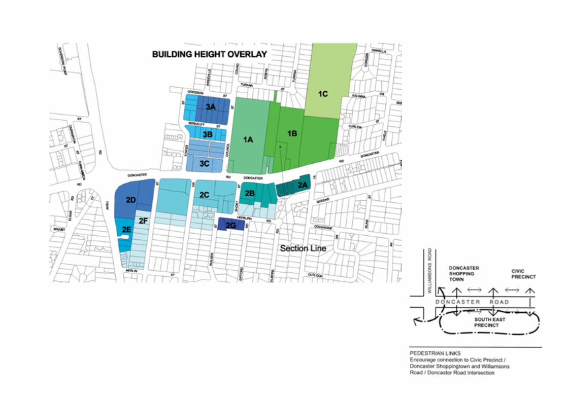
Each precinct includes a precinct description, vision, objectivesand guidelines. The 7 precincts within Doncaster Hill areidentified on the Precincts Map on the following page.


54/55>
Civic and Education Total land area: 129,389.6mPotential number of dwellings: 63 (5270 m )Precinct 1:
OBJECTIVE DESIGN GUIDELINES
Precinct 1 contains existing important civic and educationalinfrastructure for Doncaster Hill. The Precinct has a significantDoncaster Road boulevard frontage and also contains thedefining historic buildings (school and Shire Hall) for the areaand most of the existing major public open spaces. TheDoncaster Primary School is central to the Precinct and willcontinue to define the development of this and adjacentPrecincts. The precinct forms the end of a pedestrian networkrunning between the retail attraction of Westfield Shoppingtownand important civic buildings. The Precinct also containscommanding views of the Kinglake ranges to the north and theDandenong ranges to the east visible from Doncaster Boulevard.
VISION STATEMENT
The vision for Precinct 1 is the creation of a consolidated,prominent and accessible Civic Centre, with expandedcommunity and education facilities, a major civic urbanspace, and well-defined pedestrian links to Precinct 2, 3and Westfield Shoppingtown.
It is envisaged that the urban space will be formed as an attractivegreen spine, and will provide a focal point for the Manninghamcommunity for civic and community events and associatedfacilities. It is also envisaged that an enhanced historic and artsenclave focusing on the old shire offices and school building will
be an integral feature of the Precinct, with strong links to theadjoining civic area. Council aims to provide a strong leadershiprole for Doncaster Hill by investigating mixed use commercialopportunities on its gateway site and pursuing a staged, highquality development of Precinct 1.
OBJECTIVES AND GUIDELINES
In assessing proposed development and its likely impact andcontribution to Precinct 1, consideration will be given to whetherland use or development proposals address the objectives andguidelines outlined below.
1. Built Form
To encourage innovative, contemporary architectureand provide a range of unique building types.
2. Heritage
To retain and celebrate the historic character of thePrecinct and the individual buildings within it.
> Buildings shall be of a contemporary landmark character responsive to the existing municipal offices building and to the unique topographical character of the site.
> Building facades, public and private spaces should reflect the civic nature of the precinct’s functions. > Maximum height allowable where all topographic, set back and adjacent use criteria are satisfied shall be 29.0 metres
above typical ground level excluding roof structures (A.H.D. level dependant on location ).> Service and utility areas shall be integrated into the design of the building.> Development should satisfactorily address the physical conditions of the site, including northern orientation
and landform.> A range of apartment sizes and types, including different numbers of bedrooms, shall be provided.> Entries to buildings shall be visible and easily identifiable from streets and other public areas.> Entries to buildings shall provide shelter, a sense of personal address and a transitional space around the entry.
> Historic buildings should be retained and respected. To ensure prominence within Precinct 1, public uses for historic buildings should be encouraged.
2
2

56/57>
OBJECTIVE DESIGN GUIDELINES
2. Heritage (continued)
3. Pedestrian Links
To provide a permeable, safe and comfortablepedestrian environment adjacent to the proposedboulevard and with strong linkages within Doncaster Hill.
4. Vistas
To retain important vistas to middle-ground and distant features.
5. Access and Car Parking
To ensure that car parking does not dominate thelayout of the site.
To ensure vehicle access to and from a developmentis safe, manageable and convenient.
> The design of buildings adjacent to or in close proximity to an historic building should respect and complement that building in a contemporary manner taking into account scale, building form, materials, colour and lighting.
> The removal of the brick wall in front of the heritage building (the school) is encouraged to create better exposure and integration of the buildings with the public realm and to enhance pedestrian linkages along Doncaster Boulevard.
> Consolidate pedestrian links to Westfield Shoppingtown from Precinct 1 and 3.> Create pedestrian linkages with the retail precincts/active street frontages of Shoppingtown and Doncaster Boulevard.> Provide overhead weather protection features adjoining pedestrian walkways, especially at nodal points such as
pedestrian crossings, on Council or private land.
> Retain significant vistas to the northern ranges from Doncaster Boulevard (in the vicinity of the Municipal Offices) and from Schramms Reserve.
> Future car parking requirements must be integrated into the design of buildings and the unique sloping landform.> Parking areas are to be accessed from the side or rear where possible.> Encourage multi purpose parking areas that could be used for specific functions/public or community events e.g.
markets, outdoor cultural events, informal outdoor recreation activities.> Parking areas are to be well landscaped. Exterior parking areas are to include canopy trees at regular spacings, while
decked parking areas are to be softened with planting where appropriate.> All parking areas must accommodate safe, convenient pedestrian circulation, which is separated from vehicular
circulation where possible.> Vehicle crossings will be limited and strictly controlled to minimise any potential conflicts with pedestrian activity areas. > Provide high standards of car parking design that includes pedestrian access, soft landscaping, interior landscaping,
security, lighting, signage, management and maintenance.> Parking areas shall meet the access and mobility needs of users.> Encourage development of parking that serves the centre as a whole, rather than parking for individual developments
to promote provision of parking that is shared between users needing short-term visitor parking or evening parking when day time uses have ceased.
56/57>
OBJECTIVE DESIGN GUIDELINES
> Require development to incorporate bicycle parking/lock-up and facilities.> Ensure adequate emergency and service vehicle access to all developments
> Provide an attractive green spine as an outdoor ‘Events’ space incorporating features such as an amphitheatre as part of the development of the site, which is directly linked to Doncaster Boulevard , key buildings and new facilities on thesite, and which takes advantage of the northerly aspect and views.
> Building articulation and visual links to building interiors should be provided to the rear and sides of buildings extending the public realm into these areas.
> Integrate urban art, sculpture and active edges within the public realm.> Provide living areas and private open space to maximise solar access. > Provide private and communal open space areas including atriums, balconies, roof top/winter gardens etc. which link
with living areas. Balconies should have an open space area of at least 8m .> Public or communal open space areas should integrate with open space areas adjacent to development.> Public or communal open space areas should provide an outlook for as many apartments as practicable.
> Native and indigenous trees to be planted extensively throughout Precinct 1 as specified in the Landscape Guidelines in this document.
> Landscaped buffers of 2.5 metres minimum width should be provided as an interface to adjacent residential areas and adjoining sites.
> Support and maintain a consistent planting strip in support of the proposed Doncaster Boulevard.> Landscape design and layout should specify the landscape themes, vegetation (location and species), paving,
lighting, furnishings and other furniture. Landscape layout and design should allow for intended vegetation growth, retention of significant vistas and viewlines, structural protection of buildings and the creation of useable and accessible private or public open space areas.
> Entrances to buildings should not be obscured or isolated from the street and internal access ways.> Developments should be designed to provide good lighting, visibility and surveillance of car parks and internal
access ways.> Private spaces within developments should be protected from inappropriate use as public thoroughfares.
5. Access and Car Parking (cont)
6. Open Space
To retain, enhance and consolidate existing openspace where possible.
To ensure living areas and private open space islocated on the north side of the development ifpracticable.
To ensure access to useable, comfortable and welllandscaped private and communal open space.
7. Landscape
To undertake extensive planting throughout existingareas of green open space.
Landscape layout and design for developments shouldprovide an environment that is safe, attractive andfunctional for all users.
8. Safety
To ensure the layout of development provides for thesafety and security of residents, visitors, workers and property.
2


60/61>
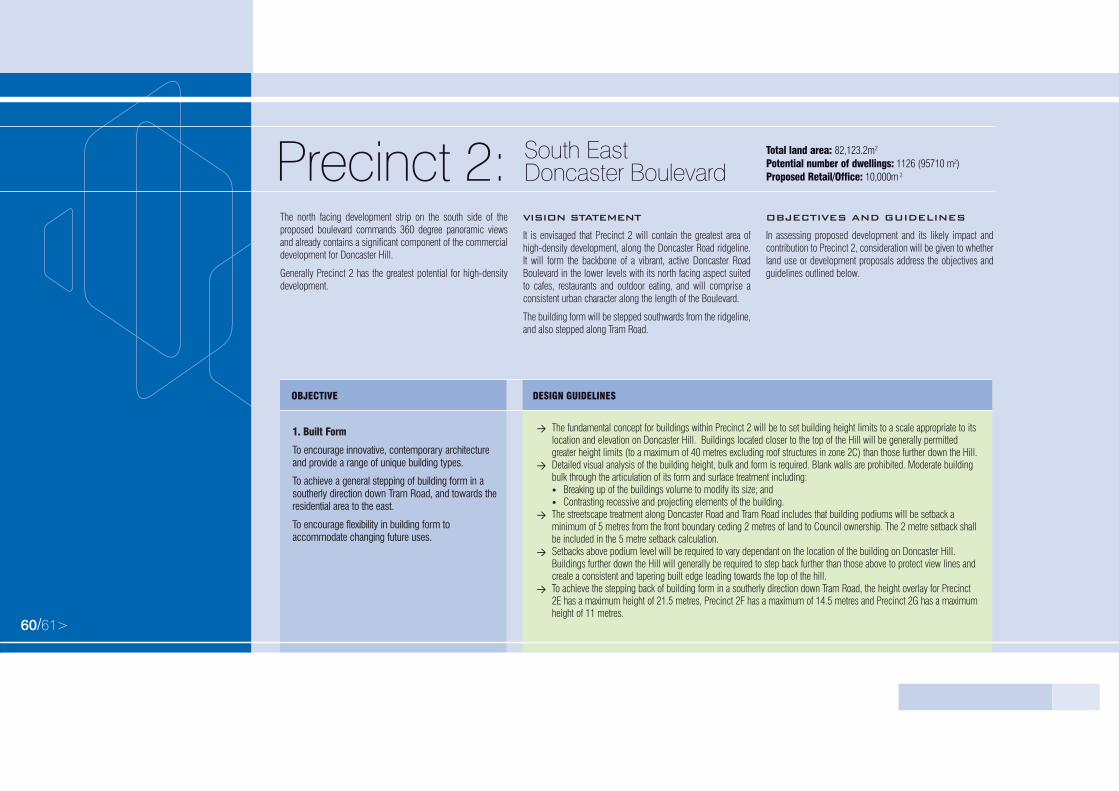
South EastDoncaster Boulevard
Total land area: 82,123.2mPotential number of dwellings: 1126 (95710 m )Proposed Retail/Office: 10,000mPrecinct 2:
OBJECTIVE DESIGN GUIDELINES
The north facing development strip on the south side of theproposed boulevard commands 360 degree panoramic viewsand already contains a significant component of the commercialdevelopment for Doncaster Hill.
Generally Precinct 2 has the greatest potential for high-densitydevelopment.
VISION STATEMENT
It is envisaged that Precinct 2 will contain the greatest area ofhigh-density development, along the Doncaster Road ridgeline.It will form the backbone of a vibrant, active Doncaster RoadBoulevard in the lower levels with its north facing aspect suitedto cafes, restaurants and outdoor eating, and will comprise aconsistent urban character along the length of the Boulevard.
The building form will be stepped southwards from the ridgeline,and also stepped along Tram Road.
OBJECTIVES AND GUIDELINES
In assessing proposed development and its likely impact andcontribution to Precinct 2, consideration will be given to whetherland use or development proposals address the objectives andguidelines outlined below.
1. Built Form
To encourage innovative, contemporary architectureand provide a range of unique building types.
To achieve a general stepping of building form in asoutherly direction down Tram Road, and towards theresidential area to the east.
To encourage flexibility in building form toaccommodate changing future uses.
> The fundamental concept for buildings within Precinct 2 will be to set building height limits to a scale appropriate to itslocation and elevation on Doncaster Hill. Buildings located closer to the top of the Hill will be generally permitted greater height limits (to a maximum of 40 metres excluding roof structures in zone 2C) than those further down the Hill.
> Detailed visual analysis of the building height, bulk and form is required. Blank walls are prohibited. Moderate building bulk through the articulation of its form and surface treatment including:• Breaking up of the buildings volume to modify its size; and • Contrasting recessive and projecting elements of the building.
> The streetscape treatment along Doncaster Road and Tram Road includes that building podiums will be setback a minimum of 5 metres from the front boundary ceding 2 metres of land to Council ownership. The 2 metre setback shallbe included in the 5 metre setback calculation.
> Setbacks above podium level will be required to vary dependant on the location of the building on Doncaster Hill. Buildings further down the Hill will generally be required to step back further than those above to protect view lines andcreate a consistent and tapering built edge leading towards the top of the hill.
> To achieve the stepping back of building form in a southerly direction down Tram Road, the height overlay for Precinct 2E has a maximum height of 21.5 metres, Precinct 2F has a maximum of 14.5 metres and Precinct 2G has a maximumheight of 11 metres.
2
2
2

60/61>
OBJECTIVE DESIGN GUIDELINES
1. Built Form (continued)
2. Boulevard Character
To achieve a consistent urban character developedalong the length of the Doncaster Road and TramRoad Boulevards.
3. Activated Street Frontage
To achieve activated street frontages in Precinct 2,particularly to Doncaster Boulevard.
4. Heritage
To retain and enhance any heritage building(s) withinPrecinct 2.
> Create a landmark gateway building at the eastern end of the site.> To encourage a range of apartment sizes and types, including different numbers of bedrooms.> Entries to buildings shall have an interesting form and be visible and easily identifiable from streets and other public
areas. Entries to buildings shall provide shelter, a sense of personal address and a transitional space around the entry.
> Development of a strong boulevard character supported by a consistent built edge and formal tree planting extending into specified setbacks is required.
> The scale at street level must be consistent. A podium of at least 3 levels should be provided along the Doncaster Boulevard frontage.
> A podium of 3 levels is also to be provided along the Tram Road frontage. Tops of podiums must be landscaped to soften the immediate environment and provide visual interest and views from above.
> Use of materials and design of functions, particularly at ground floor level, should directly engage with the street to enable the uses to be visually evident from the street and provide pedestrian interest.
> Service and utility areas must be integrated into the design of the building.> Advertising and promotional material, including signage and displays (eg vehicles and other products), must not be
located forward of the line of the building along Doncaster Road and Tram Road.
> Pedestrian generating and retail activities are encouraged at street level.> Development should address the street frontage and adjoining developments.> The scale at street level must be consistent. The use of podiums, for example, is encouraged to achieve integration
between different forms of housing and commercial usage at street level. > Provide suitably flexible floor space that can support a variety of future uses.
> Existing heritage buildings are to be retained and enhanced as part of any redevelopment proposals. > The design of buildings adjacent to or in close proximity to an historic building should respect and complement that
building in a contemporary manner taking into account scale, building form, materials, colour and lighting.> To encourage the prominence of heritage building(s) within Doncaster Hill. Public uses for heritage buildings should
be encouraged.

62/63>
OBJECTIVE DESIGN GUIDELINES
> Additional pedestrian and retail linkages of varying size character and use within the street blocks should be encouraged, including internal atriums and public open spaces.
> Strong pedestrian crossing points are to be established between the north and south sides of Doncaster Road.> Encourage positive physical connections from within corner buildings and to provide open urban spaces adjacent to
entry points to the pedestrian link proposed for the Doncaster Boulevard, Williamsons and Tram Roads intersection at the western end of the Precinct.Provide overhead weather protection features adjoining pedestrian walkways, especially at nodal points such as pedestrian crossings.
> Views to the Dandenongs, Northern Ranges, CBD and Box Hill should be exploited depending on location in Precinct 2.> Buildings must be point block construction above podium level. This ensures that buildings incorporate setbacks above
podium level at side boundaries to provide view corridors between buildings.
> Vehicular access to buildings along Doncaster Boulevard should be provided off side-streets or rear access rather than from along the Boulevard.
> Open lot parking must be minimised. The use of undercroft parking and basement parking is encouraged.> Basement car parking should be sufficiently set back from street trees and landscape buffers to allow for healthy root
establishment.> Vehicle crossings of pedestrian footpaths should be limited to the minimum necessary for access to the site. Pedestrian
amenity should be considered a priority in developing appropriate pedestrian and vehicular networks.> Future car parking requirements must be integrated into the design of buildings and the unique sloping landform.> Parking areas are to be accessed from the side or rear where possible.> Encourage multi purpose parking areas that could be used for specific functions/public or community events e.g.
markets, outdoor cultural events, informal outdoor recreation activities.> Parking areas are to be well-landscaped, both interior and exterior.> All parking areas must accommodate safe, convenient pedestrian circulation, which is separated from vehicular
circulation where possible.> Vehicle crossings will be limited and strictly controlled to minimise any potential conflicts with pedestrian
activity areas.
5. Pedestrian Links
To provide a permeable, safe and comfortablepedestrian environment adjacent to the proposedboulevard and with strong linkages withinDoncaster Hill.
To support and connect with the pedestrian linkproposed for the Doncaster Boulevard, Williamsonsand Tram Roads intersection at the western end ofthe Precinct.
6. Vistas
To capitalise on broad views and vistas obtained fromDoncaster Hill.
7. Access and Car parking
To ensure that car parking does not dominate thelayout of the site.
To ensure vehicle access to and from a developmentis safe, manageable and convenient.

62/63>
OBJECTIVE DESIGN GUIDELINES
8. Open Space
To create significant areas of open space both abuttingDoncaster Road and convenient to Precinct 2 to helpcater for the high density development within.
To ensure living areas and private open space islocated on the north side of the development ifpracticable.
To ensure access to useable, comfortable and welllandscaped private and communal open space.
9. Landscape
To create a healthy, landscaped environment on theDoncaster Hill.
Landscape layout and design for developments shouldprovide an environment that is safe, attractive andfunctional for all users.
> Provide high standards of car parking design that includes pedestrian access, soft landscaping, interior landscaping, security, lighting, signage, management and maintenance.
> Parking areas shall meet the access and mobility needs of users.> Encourage development of parking that serves the centre as a whole, rather than parking for individual developments to
promote provision of parking that is shared between users needing short-term visitor parking or evening parking when day time uses have ceased.
> Require development to incorporate bicycle parking/lock-up and facilities.> Ensure adequate emergency and service vehicle access to all developments.
> An urban open space with good solar access should be created abutting the south side of Doncaster Road, with convenient access to the north side. A further open space should be developed as a passive green park, with urban play opportunities, and located in an area convenient to the precinct with well defined pedestrian links.
> Provide living areas and private open space to maximise solar access.> Provide private and communal open space areas including atriums, balconies, roof top/winter gardens etc. Balconies
should provide an open space area of at least 8m .> Public or communal open space areas should integrate with open space areas adjacent to development.> Public or communal open space areas should provide an outlook for as many apartments as practicable.
> Support and maintain a consistent planting strip in support of Doncaster and Tram Road Boulevards and adjoining side streets.
> Developments shall provide a uniform setback from Doncaster and Tram Road Boulevards in support of the boulevard and roadside planting, ceding 2 metres of land to Council ownership. The 2 metre strip of ceded land shall be includedin the 5 metre set back calculation.
> Landscape treatment of the ceded land and balance of street frontage shall be in accordance with the landscape guidelines and carried out as part of the building development works.
> Tops of podiums must be landscaped to soften the immediate environment and provide visual interest and views from above.
> General planting to be consistent with local streetscape initiatives and adjacent public open spaces –native and indigenous planting is encouraged to be used wherever possible.
2

64/65>
OBJECTIVE DESIGN GUIDELINES
> Canopy trees are to be planted where appropriate throughout development sites.> The existing elm trees along the street frontage of 602-630 Doncaster Road are to be retained and protected
(refer Landscape Guidelines).> Landscaped buffers should be provided as an interface to adjacent residential areas.> Landscape design and layout should specify the landscape themes, vegetation (location and species), paving, lighting,
furnishings and other furniture. Landscape layout and design should allow for intended vegetation growth, structural protection of buildings and create useable and accessible private or public open space areas.
> Entrances to buildings should not be obscured or isolated from the street and internal access ways.> Developments should be designed to provide good lighting, visibility and surveillance of car parks and internal
access ways.> Private spaces within developments should be protected from inappropriate use as public thoroughfares.
9. Landscape (continued)
To create a healthy, landscaped environment on theDoncaster Hill.
Landscape layout and design for developments shouldprovide an environment that is safe, attractive andfunctional for all users.
10. Safety
To ensure the layout of development provides for thesafety and security of residents, visitors, workers andproperty.


68/69>
North East Doncaster Boulevard
Total land area: 28,624.5mPotential number of dwellings: 653 (55,505 m )Proposed Office/Retail: 4,000mPrecinct 3:
OBJECTIVE DESIGN GUIDELINES
Precinct 3 is the interface zone between the Civic and EducationPrecinct 1 to the east and Doncaster Westfield ShoppingtownPrecinct 4 to the West. Set north of Doncaster Boulevard, heightand set back requirements will vary from Precinct 2. The Precinctfalls away dramatically to the north maximising northernexposure and dramatic views to developments set out across theHill face.
VISION STATEMENT
Precinct 3 is strategically located on Doncaster Hill betweenShoppingtown and the Civic and Education Precinct, it isenvisaged that it will have a high degree of permeability,with development addressing rear lane-scapes andincluding internal atriums and well-designed publicplaza(s). Development will step down the hill, and shouldfully exploit the northerly aspect and commanding views tothe northern ranges.
OBJECTIVES AND GUIDELINES
In assessing proposed development and its likely impact andcontribution to Precinct 3, consideration will be given to whetherland use or development proposals address the objectives andguidelines outlined below.
> Buildings fundamental concept for buildings within Precinct 3 will be to set building height limits to a scale appropriate to its location and elevation on Doncaster Hill. Buildings located closer to the top of the Hill will be generally permitted greater height limits than those further down the Hill.
> Height of buildings shall conform to maximum levels nominated in the precinct height overlay diagram, the maximumheight allowed where all topographical, set back and adjacent use criteria are satisfied shall be 29.0 metres excluding roof structures.
> Buildings above podium level must be set back from the street frontage a sufficient distance to demonstrate full sun penetration onto private property on the south side of Doncaster Boulevard (including ceded land) between 11.30am and 1.30pm at the winter solstice on June 22nd.
> Detailed visual analysis of the building height, bulk and form is required. Blank walls are prohibited. Building bulk is tobe moderated through the articulation of its form and surface treatment including:• breaking up of the buildings volume to modify its size; and• contrasting recessive and projecting elements of the building.
> Developments abutting residential properties on the periphery of the Doncaster Hill area will be subject to a 11 M maximum allowable height limit within ten metres of the boundary provided that there are minimal impacts to adjoining properties.
1. Built Form
To encourage innovative, contemporary architectureand provide a range of unique building types.
2
2
2

70/71>
OBJECTIVE DESIGN GUIDELINES
> Service and utility areas must be integrated into the design of the building.> A range of apartment sizes and types, including different numbers of bedrooms, will be encouraged.> Entries to buildings shall be visible and easily identifiable from streets and other public areas.> Entries to buildings shall provide shelter, a sense of personal address and a transitional space around the entry
> Development of a strong boulevard character supported by a consistent built edge and formal tree planting extending into required setbacks.
> The scale at street level must be consistent. A podium of at least 3 levels should be provided along the Doncaster Boulevard frontage.
> Development should address the street frontage and adjoining developments.> Use of materials and design of functions, particularly at ground floor level, should directly engage with the street to
enable the uses to be visually evident from the street and provide pedestrian interest.> Advertising and promotional material, including signage and displays (eg vehicles and other products) must not be
located within the 3 metre front set-back area along Doncaster Road.
> Pedestrian generating and retail activities should be encouraged at street level.> Provide suitably flexible floor space that can support a variety of future uses.> Developments should address rear lane-scapes providing alternate residential frontage to the north in addition to
commercial and retail frontages along the Doncaster Boulevard.
> The design of buildings adjacent to or in close proximity to an historic building should respect and complement that building in a contemporary manner in terms of scale, building form, materials, colour and lighting.
> Provide a pedestrian network that will provide positive linkages to the adjacent precincts in particular to the Westfield Shoppingtown and Civic & Education precincts.
> Additional pedestrian and retail linkages of varying size, character and use within the street blocks should be encouraged, including internal atriums and public open spaces.
1. Built Form (continued)
2. Boulevard Character
To achieve a consistent urban character developedalong the length of the Doncaster Boulevard.
3. Activated Street Frontage
To achieve activated street frontages in Precinct 3,particularly to Doncaster Boulevard.
4. Heritage
To respect and complement adjoining heritagebuildings/ precincts.
5. Pedestrian Links
To provide a permeable, safe and comfortablepedestrian environment adjacent to the proposedboulevard and with strong linkages within DoncasterHill.

70/71>
OBJECTIVE DESIGN GUIDELINES
6. Vistas
To capitalise on broad views and vistas obtained fromDoncaster Hill.
7. Car parking
To ensure that car parking does not dominate thelayout of the site.
To ensure vehicle access to and from a developmentis safe, manageable and convenient.
> Development will be encouraged to fully exploit northerly aspects and views.> Buildings must be point block construction above podium level. This ensures that buildings incorporate setbacks
above podium level at side boundaries to provide view corridors between buildings.
> Parking arrangements should be carefully integrated with the design of buildings, eliminating open lot parking areas > Basement car parking should be sufficiently set back from street trees and landscape buffers to allow for healthy
root establishment.> Vehicle access to buildings along Doncaster Boulevard should be provided off side-streets rather than along
the Boulevard.> Vehicle crossings of pedestrian footpaths should be limited to the minimum necessary for access to the site.
Pedestrian amenity should be considered a priority in developing appropriate pedestrian and vehicular networks.> Future car parking requirements must be integrated into the design of buildings and the unique sloping landform.> Parking areas are to be accessed from the side or rear where possible.> Encourage multi purpose parking areas that could be used for specific functions/public or community events e.g.
markets, outdoor cultural events, informal outdoor recreation activities.> Parking areas are to be well-landscaped, both interior and exterior.> All parking areas must accommodate safe, convenient pedestrian circulation, which is separated from vehicular
circulation where possible.> Vehicle crossings will be limited and strictly controlled to minimise any potential conflicts with pedestrian
activity areas. > Provide high standards of car parking design that includes pedestrian access, soft landscaping, interior landscaping,
security, lighting, signage, management and maintenance.> Parking areas shall meet the access and mobility needs of users.> Encourage development of parking that serves the centre as a whole, rather than parking for individual developments
to promote provision of parking that is shared between users needing short-term visitor parking or evening parking when day time uses have ceased.
> Require development to incorporate bicycle parking/lock-up and facilities.> Ensure adequate emergency and service vehicle access to all developments.

72/73>
OBJECTIVE DESIGN GUIDELINES
> Encourage the inclusion of a well designed public plaza, interfacing with commercial activity, and well linked to Doncaster Road, as part of future development proposals.
> Ensure that public and private spaces have sufficient solar access, shelter and permeability, and exploit views and level changes where possible.
> Building articulation and visual links to building interiors should be provided to the rear and sides of buildings extending the public realm in these areas.
> Include public art where appropriate.> Provide living areas and private open space to maximise solar access.> Provide private and communal open space areas including atriums, balconies, roof top/winter gardens etc. Balconies
should be at least 8m .> Public or communal open space areas should integrate with open space areas adjacent to development.> Public or communal open space areas should provide an outlook for as many apartments as practicable.
> Support and maintain a consistent planting strip in support of Doncaster Boulevard and adjoining side streets.> Tops of podiums must be landscaped to soften the immediate environment and provide visual interest and views from above.> Landscaped treatment provided as part of the interface to adjacent residential areas.> Planting should be consistent with local streetscape initiatives and adjacent public open spaces. Native and
indigenous planting is encouraged to be used wherever possible.> Canopy trees are to be planted wherever possible throughout development sites.> Developments shall provide a uniform setback from Doncaster Boulevard in support of the boulevard and roadside
planting, ceding 2 metres of land to council ownership. The 2 metre strip of land may be included in the 5 metre set back calculation.
> Landscape development and paving of the ceded land shall be in accordance with guidelines established by the Manningham City Council and carried out as part of the building development works.
> Landscape design and layout should specify the landscape themes, vegetation (location and species), paving, lighting, furnishings and other furniture. Landscape layout and design should allow for intended vegetation growth, structural protection of buildings and create useable and accessible private or public open space areas.
> Entrances to buildings should not be obscured or isolated from the street and internal access ways.> Developments should be designed to provide good lighting, visibility and surveillance of car parks and internal access ways.> Private spaces within developments should be protected from inappropriate use as public thoroughfares.
8. Open Space
To create a sufficient area of permeable open space inprecinct 3.
To ensure living areas and private open space islocated on the north side of the development ifpracticable.
To ensure access to useable, comfortable and welllandscaped private and communal open space.
9. Landscape
To create a healthy, landscaped environment on theDoncaster Hill.
Landscape layout and design for developments shouldprovide an environment that is safe, attractive andfunctional for all users.
10. Safety
To ensure the layout of development provides for thesafety and security of residents, visitors, workers andproperty.
2


76/77>
Doncaster Westfield Shoppingtown
Total land area: 161, 064.7mPotential number of dwellings: 67 (5,695m )Proposed Office/Retail: 135,000mPrecinct 4:
OBJECTIVE DESIGN GUIDELINES
Central to the defined Activity Centre, the site is a major regionalshopping centre (Westfield Shoppingtown Doncaster) withsignificant frontages to both Williamsons Road and the proposedDoncaster Boulevard. The single consolidated site commandspanoramic views to the north and west and occupies thedominant corner of the Doncaster Boulevard and WilliamsonsRoad intersection. The tower currently occupying the centre of thesite is already a regional landmark visible from a radius of manykilometres. The depth and scale of the site and the significantfrontages presented to both Doncaster Boulevard and WilliamsonsRoad contribute to the great future development potential of thissite in the context of the Doncaster Hill Activity Centre.
VISION STATEMENT
It is envisaged that Westfield Shoppingtown will become betterintegrated into Doncaster Hill and the surrounding communitywith activated street frontages, more permeable pedestrian andvehicular accessibility, a greater mix of uses, accessible andprominent public transport interchange, pedestrian linkages toother precincts, and improved engagement with the mainintersection.
OBJECTIVES AND GUIDELINES
In assessing proposed development and its likely impact andcontribution to the Precinct, consideration will be given towhether land use or development proposals address theobjectives guidelines outlined below.
> Future development is to respond to the natural and built form elements including topography, climate and orientation,vegetation and built form objectives to surrounding precincts.
> Height of buildings shall conform to maximum levels nominated in the precinct height overlay diagram. The maximum height varies depending on the location within Precinct 4.
> Detailed visual analysis of the building height, bulk and form is required. Blank walls are prohibited. Building bulk is tobe moderated through the articulation of its form and surface treatment including;• breaking up of the buildings volume to modify its size; and• contrasting recessive and projecting elements of the building.
> Service and utility areas must be integrated into the design of the building.> A suitable transition of the scale of future building form is to be achieved at the interface with adjoining residential
areas. Development will be subject to a 11 metre maximum allowable height limit within 10 metres of a residential boundary provided that there are minimal impacts on adjoining properties.
> The development of a landmark tower building at the Doncaster Boulevard and Williamsons Road intersection is encouraged.
1. Built Form
To better integrate Westfield Shoppingtown intoDoncaster Hill.
To encourage innovative, contemporary architecture inwhich the retail component is externalised.
To provide a positive engagement of the Precinct withthe main intersection of the Doncaster Boulevard andWilliamsons Road.
2
2
2

78/79>
OBJECTIVE DESIGN GUIDELINES
> The development of a unique gateway building abutting Williamsons Road in the north-west corner of the precinct is encouraged.
> To encourage a range of apartment sizes and types, including different numbers of bedrooms.> Entries to buildings shall be visible and easily identifiable from streets and other public areas. Entries to buildings
shall provide shelter, a sense of personal address and a transitional space around the entry.
> The scale at street level must be consistent. A podium of at least 3 levels should be provided along the Doncaster Boulevard and Williamsons Road frontages.
> Use of materials and design of functions, particularly at ground floor level, should directly engage with Doncaster Boulevard, Williamsons Road and Tower Street to enable the uses to be visually evident and accessible from the streetand provide pedestrian interest.
> Advertising and promotional material, including signage and displays (eg vehicles and other products), must not be located forward of the line of the building along Doncaster and Williamsons Roads.
> Ensure that development along Doncaster Boulevard and Williamsons Road incorporates uses and design that ensuresactive street frontages that engages and offers visual interest and accessibility to pedestrians.
> The buildings must address the street. Building articulation and visual links to building interiors should be provided to the rear and sides of buildings extending the public realm in these areas.
> Provide an integrated public transport interchange to support both Westfield Shoppingtown and the greater Doncaster Hill area in a prominent and easily accessible location.
> A library is to be provided in a prominent and easily accessible location.> A police station is to be considered in future development proposals.
> Creation of pedestrian friendly interface between Westfield Shoppingtown, Doncaster Boulevard, Williamsons Road and Tower Street
> Establish strong pedestrian entries and linkages from Westfield Shoppingtown to all other precincts within Doncaster Hill.
1. Built Form (continued)
2. Boulevard Character
To achieve a consistent urban character developedalong the length of the Doncaster Boulevard.
3. Activated Street Frontage
To achieve activated street frontages to DoncasterBoulevard and Williamsons Road.
To provide social and community services andfacilities in a prominent and easily accessible location.
To provide opportunities for a range of residential andcommercial uses to develop on the site along with theretail development.
4. Pedestrian Links To provide a permeable, safe and comfortablepedestrian environment with strong linkages toDoncaster Hill.
Development should improve and enhance pedestrian,bicycle and vehicular access within Precinct 4 and toadjoining precinct areas.

78/79>
OBJECTIVE DESIGN GUIDELINES
4. Pedestrian Links (continued)
5. Vistas
To capitalise on view and vistas external to the site.
6. Access and car parking
To accommodate future car parking requirementswithin the building form.
To ensure vehicle access to and from a developmentis safe, manageable and convenient.
> Encourage positive physical connections from within corner buildings and to provide open urban spaces adjacent to entry points to the pedestrian link proposed for the Doncaster Boulevard, Williamsons and Tram Roads intersection at the western end of the precinct.
> To support and connect with the pedestrian link proposed for the Doncaster Boulevard, Williamsons and Tram Roads intersection at the western end of the precinct.
> Future building form is to fully exploit the northeast aspect and views, and vistas to the CBD.> Buildings must be point block construction above podium level. This ensures that buildings incorporate setbacks
above podium level at side boundaries to provide view corridors between buildings.
> Open lot parking must be minimised. The use of undercroft parking and basement parking is encouraged.> Basement car parking should be sufficiently set back from street trees and landscape buffers to allow for healthy
root establishment.> Vehicular and pedestrian circulation paths must be clearly separated, with potential conflicts minimised.> All parking areas need to be well- landscaped and irrigated, both interior and exterior, with canopy trees being
planted throughout external parking areas.> Future car parking requirements must be integrated into the design of buildings and the unique sloping landform.> Encourage multi purpose parking areas that could be used for specific functions/public or community events
e.g. markets, outdoor cultural events, informal outdoor recreation activities.> Parking areas are to be well-landscaped, both interior and exterior.> All parking areas must accommodate safe, convenient pedestrian circulation, which is separated from vehicular
circulation where possible.> Vehicle crossings will be limited and strictly controlled to minimise any potential conflicts with pedestrian
activity areas. > Provide high standards of car parking design that includes pedestrian access, soft landscaping, interior landscaping,
security, lighting, signage, management and maintenance.> Parking areas shall meet the access and mobility needs of users.> Require development to incorporate bicycle parking/lock-up and facilities.> Ensure adequate emergency and service vehicle access to all developments.
80/81>
OBJECTIVE DESIGN GUIDELINES
> External spaces should be directly linked to commercial or other people-intensive activity, provide shelter and capitalise on views and solar access.
> External spaces should directly link to Williamsons Road and Doncaster Road where appropriate. > Consider the integration of urban art and sculpture within the public realm.> Provide living areas and private open space to maximise solar access.> Provide private and communal open space areas including atriums, balconies, roof top/winter gardens etc. Balconies
should provide open space areas of at least 8m .> Public or communal open space areas should integrate with open space areas adjacent to development.> Public or communal open space areas should provide an outlook for as many apartments as practicable.> When affected by building works, existing communal open spaces used by shoppers and workers are to be recreated
in alternative high profile locations.
> The interface between the development and adjacent residential areas to the north and east is to be respectful of the scale and privacy of adjoining residences. The use of effective landscaped buffer zones of native and indigenous vegetation is encouraged.
> Canopy trees are to be planted wherever possible throughout the total site.> Developments shall provide a uniform setback from Doncaster Road and Williamsons Road in support of the
boulevard and roadside planting, ceding 2 metres of land to council ownership. The 2 metre strip of land may be included in the 5 metre set back calculation.
> Landscape development and paving of the ceded land shall be in accordance with guidelines established by the Manningham City Council and carried out as part of the building development works.
> Landscape design and layout should specify the landscape themes, vegetation (location and species), paving, lighting, furnishings and other furniture. Landscape layout and design should allow for intended vegetation growth, structural protection of buildings and create useable and accessible private or public open space areas.
> Entrances to buildings should not be obscured or isolated from the street and internal access ways.> Developments should be designed to provide good lighting, visibility and surveillance of car parks and internal
access ways.> Private spaces within developments should be protected from inappropriate use as public thoroughfares.
7. Open Space
To create a number of significant externalised urbanspaces, which are well connected within a permeableurban environment.
To ensure living areas and private open space islocated on the north side of the development ifpracticable.
To ensure access to useable, comfortable and welllandscaped private and communal open space.
8. Landscape
To support and maintain a consistent planting strip insupport of the proposed boulevard and alongWilliamsons Road.
Landscape layout and design for developments shouldprovide an environment that is safe, attractive andfunctional for all users.
10. Safety
To ensure the layout of development provides for thesafety and security of residents, visitors, workers andproperty.
2
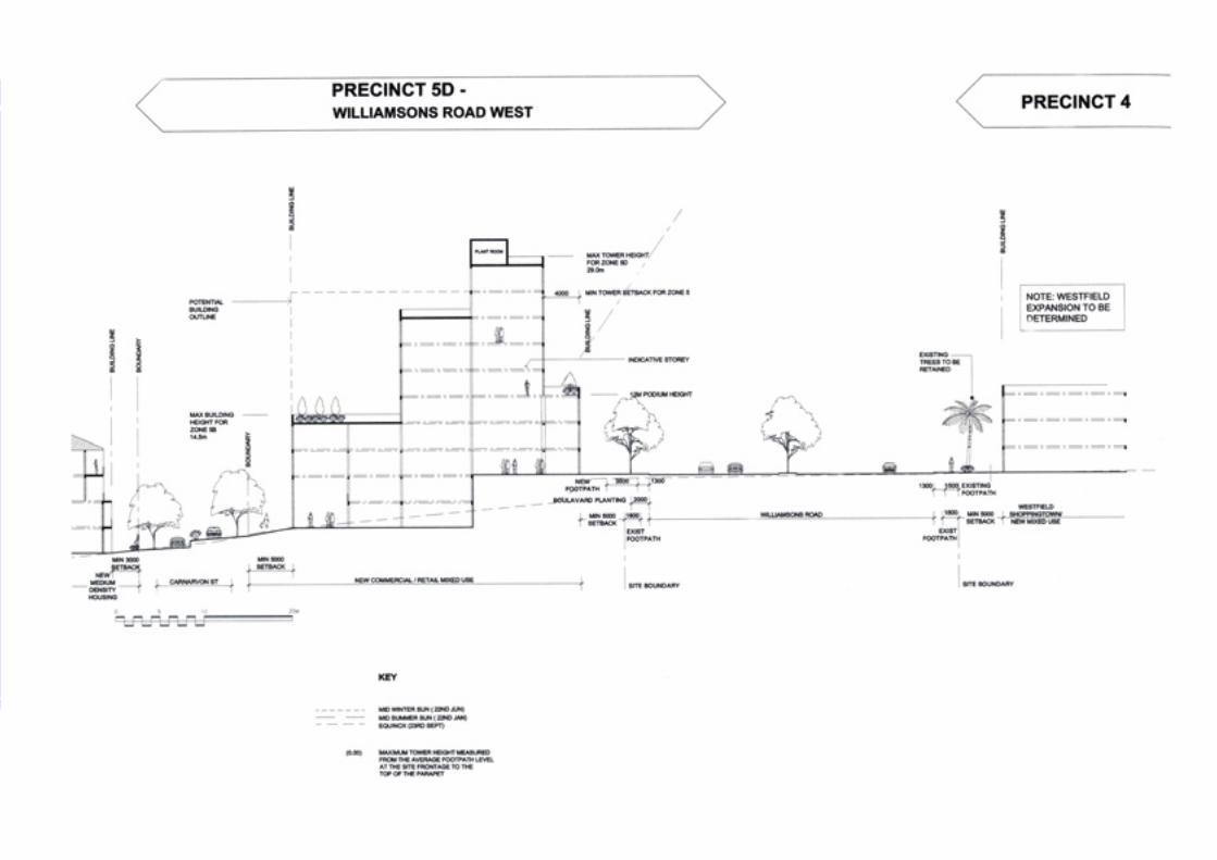


84/85>
Williamsons Road West
Total land area: 44,510.0mPotential number of dwellings: 529 (44,965m )Proposed Office/Retail: 3,500mPrecinct 5:
OBJECTIVE DESIGN GUIDELINES
Precinct 5 contains The Crest, Sovereign Point and The Ridgeapartment buildings, the only existing high density housingdevelopments on the Hill and the Doncaster Hotel, the thirdlargest single consolidated site within Doncaster Hill. The sitecontains panoramic city skyline views to the west and directaccess to open space and parkland along its southern boundary.Linkages across Williamsons Road to Westfield Shoppingtowncontribute to the opportunities offered by this site.
VISION STATEMENT
It is envisaged that high density development will continue to bebuilt along the Williamsons Road ridgeline in Precinct 5, withless dense development progressively stepping down the hilltowards the west. View-lines from Williamsons Road to the cityskyline are to be retained at strategic points, including frompublic open space.
An improved pedestrian network will provide stronger links withWestfield Shoppingtown, public transport interchanges, andnearby open space. Existing green open space in the near vicinity(Lawford Reserve) will be improved, and new high quality openspace will be created
OBJECTIVES AND GUIDELINES
In assessing proposed development and its likely impact andcontribution to the Precinct, consideration will be given towhether land use or development proposals address theobjectives and guidelines outlined below.
> The fundamental concept for buildings within the precinct will be to set building height limits to a scale appropriate to its location and elevation on the slope of Doncaster Hill. Buildings located closer to the top of the hill will be generally permitted greater height limits than those further down the hill towards the west.
> Height of buildings shall conform to maximum levels nominated in the precinct height overlay diagram, the maximumheight allowed where all topographical, set back and adjacent use criteria are satisfied shall be 36.0 metres.
> A detailed visual analysis of the building height, bulk and form must be undertaken. Blank walls are prohibited. Moderation of building bulk is to be achieved through the articulation of form and surface treatment including:
> Breaking up of the building’s volume to modify its size; and> Contrasting recessive and projecting elements of the building.> Service and utility areas must be integrated into the design of the building.> Overlooking and overshadowing of dwellings both within and beyond the development shall be minimised.> Developments abutting residential properties on the periphery of Doncaster Hill will be subject to an 11 metre
maximum allowable height limit within 10 metres of the boundary provided that there are minimal impacts to adjoining properties.
> To encourage a range of apartment sizes and types, including different numbers of bedrooms.> Entries to buildings shall be visible and easily identifiable from streets and other public areas. Entries to buildings
shall provide shelter, a sense of personal address and a transitional space around the entry.
1. Built Form
To encourage innovative, contemporary architectureand provide a range of unique building types.
To encourage flexibility in building form toaccommodate changing future uses.
2
2
2

86/87>
OBJECTIVE DESIGN GUIDELINES
> Development should address the street frontage and adjoining developments.> The scale at street level must be consistent. A podium of at least 3 levels should be provided along the Williamsons
road frontage to achieve integration between different forms of housing and commercial usage at street level.> Buildings must be set back 5 metres from the street frontage.> Use of materials and design of functions, particularly at ground floor level, should directly engage with the street to
enable the uses to be visually evident from the street and provide pedestrian interest.> Advertising and promotional material, including signage and displays (eg vehicles and other products), must not be
located within the 3 metre front setback area along Williamsons Road.
> Pedestrian generating and retail activities are encouraged at street level. > Provide suitably flexible floor space that can support a variety of future uses.> Additional pedestrian and retail linkages of varying size, character and use within the street blocks should be
encouraged, including internal atriums and public open spaces.
> Provide a pedestrian network that will provide positive linkages to the adjacent precincts in particular the Westfield Shoppingtown site, public transport interchanges and the open space of the Lawford Street Reserve.
> Support and connect with the pedestrian link proposed for the Doncaster Boulevard, Williamsons and Tram Roads intersection at the southern end of the precinct.
> Strategic view corridors towards the city from Williamsons Road are to be retained within future development from specially created public space areas between buildings. A long continuous wall of building shall be discouraged.
> Buildings must be point block construction above podium level. This ensures that buildings incorporate setbacks above podium level at side boundaries to provide view corridors between buildings from Williamsons Road.
2. Boulevard Character
To achieve a consistent urban character developedalong the length of the Williamsons Road andDoncaster Road Boulevards.
3. Activated Street Frontage
To achieve activated street frontages along the westside of Williamsons Road.
4. Pedestrian Links
To provide a permeable, safe and comfortablepedestrian environment adjacent to the proposedboulevard and with strong linkages within Doncaster Hill.
5. Vistas
To capitalise on broad views and vistas obtained fromthe Williamsons Road ridgeline.

86/87>
OBJECTIVE DESIGN GUIDELINES
6. Access and Car parking
To ensure that car parking does not dominate thelayout of the site.
To ensure vehicle access to and from a developmentis safe, manageable and convenient.
7. Open Space
To create a significant area of open space both withinand convenient to Precinct 5 to help cater for theproposed high-density development in the surroundingprecincts.
> Parking arrangements should be carefully integrated with the design of buildings, eliminating open lot parking areas.> The use of undercroft parking and basement parking is encouraged. > Basement car parking should be sufficiently set back from street trees and landscape buffers to allow for healthy root
establishment.> Vehicle crossings of pedestrian footpaths should be limited to the minimum necessary for access to the site.
Pedestrian amenity should be considered a priority in developing appropriate pedestrian and vehicular networks.> Future car parking requirements must be integrated into the design of buildings and the unique sloping landform.> Parking areas are to be accessed from the side or rear where possible.> The existing extent of car parking is to be rationalised when future development occurs, so that more land area is given
over to passive open space. > Encourage multi purpose parking areas that could be used for specific functions/public or community events e.g.
markets, outdoor cultural events, informal outdoor recreation activities.> Parking areas are to be well-landscaped, both interior and exterior.> All parking areas must accommodate safe, convenient pedestrian circulation, which is separated from vehicular
circulation where possible.> Vehicle crossings will be limited and strictly controlled to minimise any potential conflicts with pedestrian
activity areas. > Provide high standards of car parking design that includes pedestrian access, soft landscaping, interior landscaping,
security, lighting, signage, management and maintenance.> Parking areas shall meet the access and mobility needs of users.> Encourage development of parking that serves the centre as a whole, rather than parking for individual developments
to promote provision of parking that is shared between users needing short-term visitor parking or evening parking when day time uses have ceased.
> Require development to incorporate bicycle parking/lock-up and facilities.> Ensure adequate emergency and service vehicle access to all developments.
> Encourage the inclusion of public open space abutting Williamsons Road that accommodates vistas to the city and has convenient links to Shoppingtown.
> Consolidate and improve linkages to the significant passive open space of Lawford Reserve. > Integrate urban art and sculpture within the public realm.

88/89>
OBJECTIVE DESIGN GUIDELINES
> Provide living areas and private open space to maximise solar access.> Provide private and communal open space areas including atriums, balconies, roof top/winter gardens etc. Balconies
should be at least 8m2.> Public or communal open space areas should integrate with open space areas adjacent to development.> Public or communal open space areas should provide an outlook for as many apartments as practicable.
> Support and maintain a consistent planting strip in support of Williamsons Road Boulevard and adjoining side streets.> Landscaped buffers will be provided as an interface to adjacent residential areas.> Planting is to be consistent with local streetscape initiatives and adjacent public open spaces. Native and indigenous
planting is encouraged to be used wherever possible.> Canopy trees are to be planted where appropriate throughout development sites.> Lawford Reserve and adjoining streets are to be further planted to create a continuous green canopy.> Landscape design and layout should specify the landscape themes, vegetation (location and species), paving,
lighting, furnishings and other furniture. Landscape layout and design should allow for intended vegetation growth, structural protection of buildings and create useable and accessible private or public open space areas.
> Entrances to buildings should not be obscured or isolated from the street and internal access ways.> Developments should be designed to provide good lighting, visibility and surveillance of car parks and internal
access ways.> Private spaces within developments should be protected from inappropriate use as public thoroughfares.
7. Open Space (continued)
To ensure living areas and private open space islocated on the north side of the development ifpracticable.
To ensure access to useable, comfortable and welllandscaped private and communal open space.
8. Landscape
To create a healthy, landscaped environment onDoncaster Hill.
Landscape layout and design for developments shouldprovide an environment that is safe, attractive andfunctional for all users.
9. Safety
To ensure the layout of development provides for thesafety and security of residents, visitors, workers andproperty.


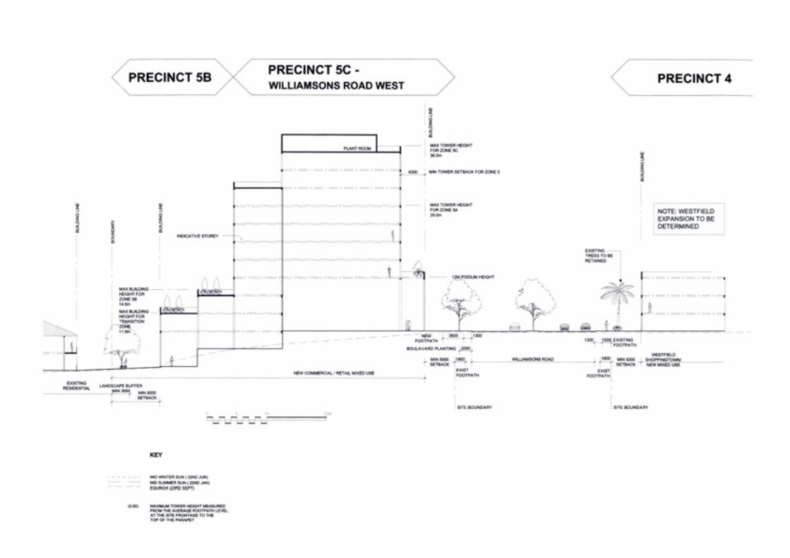
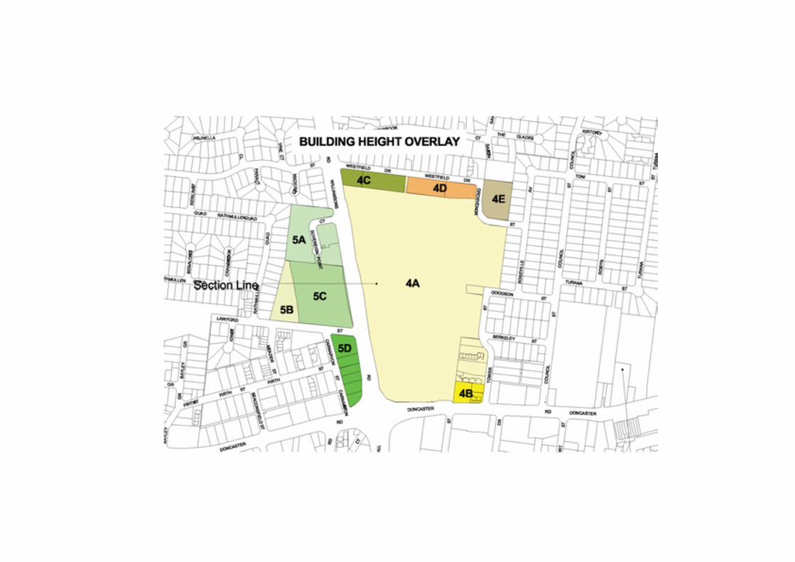

92/93>
North West Doncaster Boulevard
Total land area: 64,575.1mPotential number of dwellings: 855 (72,675m )Proposed Office/Retail: 2,500mPrecinct 6:
OBJECTIVE DESIGN GUIDELINES
Precinct 6 contains the pivotal Gateway landmark site to the northof Doncaster Boulevard marking the western edge of DoncasterHill and Doncaster Boulevard. The precinct presently has a strongcommercial / light industrial character, especially alongDoncaster Boulevard, with older, walk-up apartment blocks alongFirth Street.
VISION STATEMENT
Precinct 6 will provide medium scale commercial developmenton smaller sized allotments with uniform setbacks, buildingheights and landscape requirements, giving way to mediumdensity housing towards the rear of the precinct. The vision forPrecinct 6 is to create a vibrant and commercially viable mixeduse village of a smaller scale than is proposed for precinctslocated further east in Doncaster Hill. The Boulevard characterwill be extended along the adjoining length of DoncasterBoulevard. A Gateway building is envisaged to be developed atthe western end of the precinct marking the beginning of the
Doncaster Hill Strategy Activity Centre and the DoncasterBoulevard, while pedestrian links are proposed to connect withLawford Reserve and the Doncaster Boulevard, Williamsons andTram Roads intersection at the eastern end of the precinct.
OBJECTIVES AND GUIDELINES
In assessing proposed development and its likely impact andcontribution to the Precinct, consideration will be given towhether land use or development proposals address the keyobjectives and guidelines outlined below.
> Buildings within the Precinct will conform to set building height limits to a scale appropriate to its location and overall site area.
> Developments must demonstrate the appropriateness of the allowable maximum height limit through sectional studies, overlooking and shadow diagram analysis.
> Height of buildings shall conform to maximum levels nominated in the precinct height overlay diagram; the maximumheight allowed where all topographical, set back and adjacent use criteria are satisfied shall be 21.5 metres, excludingplant room.
> Detailed visual analysis of the building height, bulk and form must be undertaken. Blank walls are prohibited. Moderation of building bulk is to be achieved through the articulation of its form and surface treatment including:
> Breaking up of the buildings volume to modify its size; and > Contrasting recessive and projecting elements of the building.> Service and utility areas must be integrated into the design of the building.> Provide suitably flexible floors space that can support a variety of future uses.
1. Built Form
To encourage innovative, contemporary architectureand provide a range of unique building types.
To encourage flexibility in building form toaccommodate changing future uses.
To encourage the development of a Gateway buildingat the western end of the precinct marking thebeginning of the Doncaster Hill Activity Centre and theDoncaster Boulevard.
2
2
2

94/95>
OBJECTIVE DESIGN GUIDELINES
> Buildings must be point block construction above podium level. This ensures that buildings incorporate setbacks above podium level at side boundaries to provide view corridors between buildings.
> Developments abutting residential properties on the periphery of Doncaster Hill will be subject to an 11 metre maximum allowable height limit within 10 metres of the boundary provided that there are minimal impacts to adjoining properties.
> To encourage a range of apartment sizes and types, including different numbers of bedrooms.> Entries to buildings shall be visible and easily identifiable from streets and other public areas.> Entries to buildings shall provide shelter, a sense of personal address and a transitional space around the entry.
> Development of a strong boulevard character supported by a consistent built edge and formal tree planting extending into specified setbacks is required.
> The scale at street level should be consistent to encourage integration between different forms of housing and commercial usage at street level.
> Use of materials and design of functions, particularly at ground floor level, should directly engage with the street to enable the uses to be visually evident from the street and provide pedestrian interest.
> Developments shall provide a uniform setback from Doncaster Boulevard in support of the boulevard and roadside planting, ceding 2 metres of land to council ownership.
> The 2 metre strip of land may be included in the 5 metre set back calculation.Advertising and promotional material, including signage and displays (eg vehicles and other products), must not be located within the 3 metre front set-back area along Doncaster Road.
> Encourage the development of buildings supporting an integrated and diverse range of commercial and residential uses.
> Pedestrian generating and retail activities should be encouraged at street level along Doncaster Boulevard.
> Support and connect with the pedestrian link proposed for the Doncaster Boulevard, Williamsons and Tram Roads intersection at the eastern end of the precinct.
> Strengthen linkages to Precinct 7 and to Lawford Street Reserve.
1. Built Form (continued)
2. Boulevard Character
To achieve a consistent urban character developedalong the length of the Doncaster Boulevard.
Development should address the street frontage andadjoining developments.
3. Activated Street Frontage
To create a vibrant and commercially viable mixed usevillage of a smaller scale than is proposed forprecincts located further east in Doncaster Hill.
4. Pedestrian Links
To provide a permeable, safe and comfortablepedestrian environment adjacent to the proposedboulevard and with strong linkages within Doncaster Hill.

94/95>
OBJECTIVE DESIGN GUIDELINES
5. Access and Car parking
To ensure that car parking does not dominate thelayout of the site.
To ensure vehicle access to and from a developmentis safe, manageable and convenient.
6. Open Space
To ensure that each precinct has ready access to welldesigned public open space.
To ensure living areas and private open space is locatedon the north side of the development if practicable.
To ensure access to useable, comfortable and welllandscaped private and communal open space.
> Parking arrangements should be carefully integrated with the design of buildings, eliminating open lot parking areas.> The use of undercroft parking and basement parking is encouraged.> Basement car parking should be sufficiently set back from street trees and landscape buffers to allow for healthy
root establishment.> Vehicle crossings of pedestrian footpaths should be limited to the minimum necessary for access to the site.
Pedestrian amenity should be considered a priority in developing appropriate pedestrian and vehicular networks.> Future car parking requirements must be integrated into the design of buildings and the unique sloping landform.> Parking areas are to be accessed from the side or rear where possible.> The existing extent of car parking is to be rationalised when future development occurs, so that more land area is given
over to passive open space. > Encourage multi purpose parking areas that could be used for specific functions/public or community events e.g.
markets, outdoor cultural events, informal outdoor recreation activities.> Parking areas are to be well-landscaped, both interior and exterior.> All parking areas must accommodate safe, convenient pedestrian circulation, which is separated from vehicular
circulation where possible.> Vehicle crossings will be limited and strictly controlled to minimise any potential conflicts with pedestrian
activity areas. > Provide high standards of car parking design that includes pedestrian access, soft landscaping, interior landscaping,
security, lighting, signage, management and maintenance.> Parking areas shall meet the access and mobility needs of users.> Encourage development of parking that serves the centre as a whole, rather than parking for individual developments
to promote provision of parking that is shared between users needing short-term visitor parking or evening parking when day time uses have ceased.
> Require development to incorporate bicycle parking/lock-up and facilities.> Ensure adequate emergency and service vehicle access to all developments.
> Improve the passive open space quality of nearby Lawford Reserve, and improve linkages to the reserve.> Provide living areas and private open space to maximise solar access.> Provide private and communal open space areas including atriums, balconies, roof top/winter gardens etc. Balconies
should be at least 8m .> Public or communal open space areas should integrate with open space areas adjacent to development.> Public or communal open space areas should provide an outlook for as many apartments as practicable.
2

96/97>
OBJECTIVE DESIGN GUIDELINES
> Support and maintain a consistent planting strip in support of Doncaster Boulevard and adjoining side streets.> Planting is to be consistent with local streetscape initiatives and adjacent public open spaces. Native and indigenous
planting is encouraged wherever possible.> Canopy trees are to be planted where appropriate throughout development sites.> Landscaped buffers will be provided as an interface to adjacent residential areas.> Landscape design and layout should specify the landscape themes, vegetation (location and species), paving,
lighting, furnishings and other furniture. Landscape layout and design should allow for intended vegetation growth, structural protection of buildings and create useable and accessible private or public open space areas.
> Entrances to buildings should not be obscured or isolated from the street and internal access ways.> Developments should be designed to provide good lighting, visibility and surveillance of car parks and internal
access ways.> Private spaces within developments should be protected from inappropriate use as public thoroughfares.
7. Landscape
To create a healthy, landscaped environment onDoncaster Hill.
Landscape layout and design for developments shouldprovide and environment that is safe, attractive andfunctional for all users.
8. Safety
To ensure the layout of development provides for thesafety and security of residents, visitors, workers andproperty.

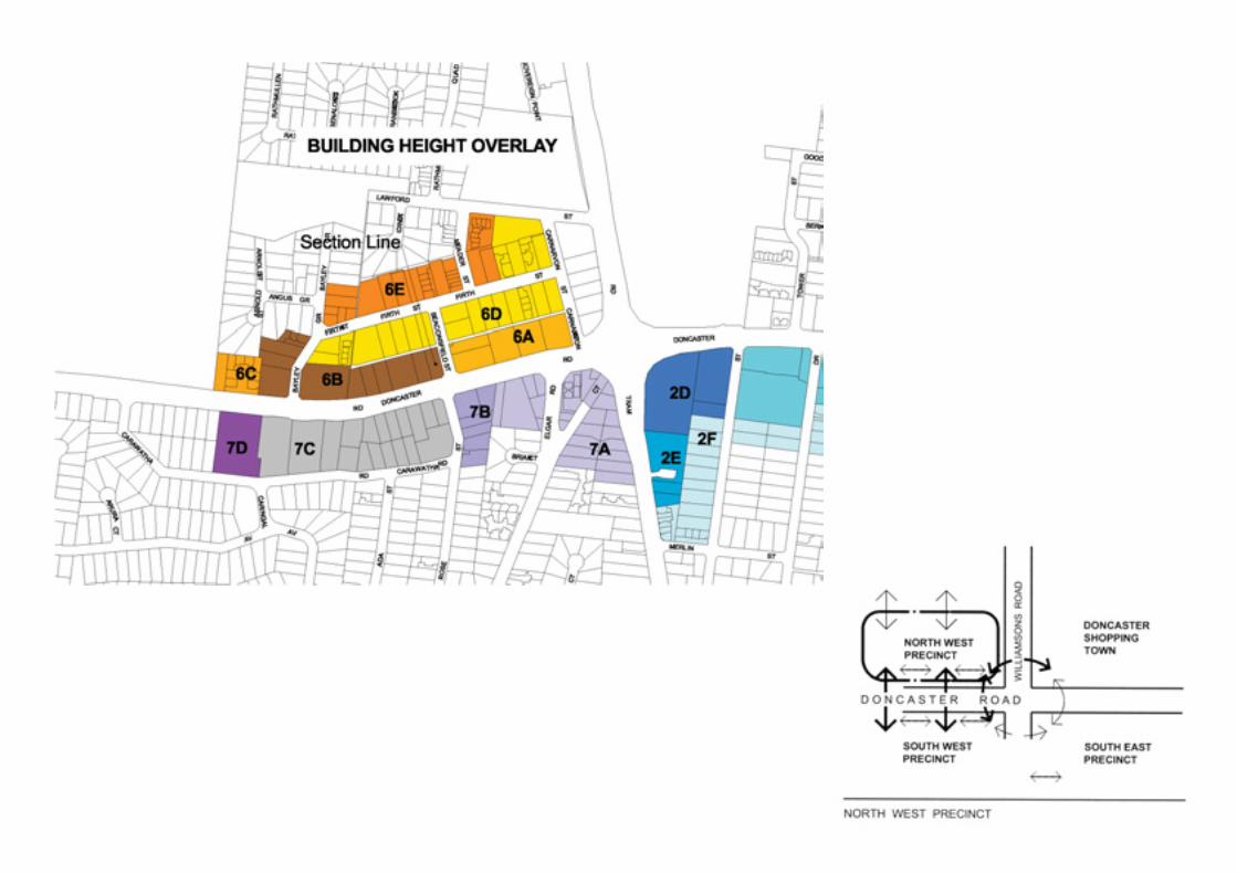

98/99>
South West Doncaster Boulevard
Total land area: 54,715.8mPotential number of dwellings: 788 (66,980m )Proposed Office/Retail: 10,0002mPrecinct 7:
OBJECTIVE DESIGN GUIDELINES
Precinct 7 is a Gateway precinct with a high availability of largerdevelopment sites with high-density development potential. Itsunique location on Doncaster Hill ensures wide-ranging views tothe City and over the adjacent Golf links.
Precinct 7 contains the pivotal Gateway landmark site to thesouth of Doncaster Boulevard marking the western edge ofDoncaster Hill and Doncaster Boulevard.
The precinct is presently characterised by light industrial andcommercial uses, including a number of restaurants at the westend and also including some residential land uses to the south ofthe precinct. It creates a visually poor entrance to Doncaster Hill.
VISION STATEMENT
The vision for Precinct 7 is to create a vibrant and commerciallyviable mixed use village of a smaller scale than is proposed forprecincts located further east in Doncaster Hill. It is envisagedthat the precinct will be developed as a major gateway toDoncaster Hill, including a Gateway building at the western endof the precinct marking the beginning of the Doncaster HillActivity Centre and the Doncaster Boulevard.
OBJECTIVES AND GUIDELINES
In assessing proposed development and its likely impact andcontribution to Precinct 7, consideration will be given to whetherland use or development proposals address the objectives andguidelines outlined below.
> Height of buildings shall conform to maximum levels nominated in the precinct height overlay diagram, the maximumheight allowed where all topographical, set back and adjacent use criteria are satisfied shall be 29.0 metres excluding any roof structures.
> Set backs from Doncaster Boulevard will conform to the set back line determined by the minimum set back of 5 metres at the corner of Elgar Road and Doncaster Boulevard and the maximum set back of 10 metres at the Western most end of the building further down the Hill will generally be required to step back further than those above to protect view lines and create a consistent and tapering built edge leading towards the top of the Hill.
> A detailed visual analysis of the building height, bulk and form must be undertaken. Blank walls are prohibited. Moderation of building bulk is to be achieved through the articulation of form and surface treatment including:
> Breaking up of the building’s volume to modify its size; and> Contrasting recessive and projecting elements of the building.> Service and utility areas must be integrated into the design of the building.> Provide suitably flexible floorspace that can support a variety of future uses.> Buildings must be point block construction above podium level. This ensures that buildings incorporate setbacks
above podium level at side boundaries to provide view corridors between buildings.
1. Built Form
To encourage innovative, contemporary architectureand provide a range of unique building types.
Buildings within the Precinct will conform to setbuilding height limits to a scale appropriate to itslocation and overall site area.
To encourage the development of a Gateway buildingat the western end of the precinct marking thebeginning of the Doncaster Hill Activity Centre and theDoncaster Boulevard.
2
2
2

100/101>
OBJECTIVE DESIGN GUIDELINES
> Developments abutting residential properties on the periphery of Doncaster Hill will be subject to an 11 M maximum allowable height limit within ten metres of the boundary provided that there are minimal impacts to adjoining properties.
> Entries to buildings shall be visible and easily identifiable from streets and other public areas.Entries to buildings shall provide shelter, a sense of personal address and a transitional space around the entry.
> The scale at street level should be consistent to encourage integration between different forms of housing and commercial usage at street level.
> Use of materials and design of functions, particularly at ground floor level, should directly engage with the street to enable the uses to be visually evident from the street and provide pedestrian interest.
> The scale at street level must be consistent. A podium of at least 3 levels should be provided along the Doncaster Boulevard frontage.
> Developments shall provide a uniform setback from Doncaster Boulevard in support of the boulevard and roadside planting, ceding 2 metres of land to council ownership.
> Landscape treatment of the ceded land shall be in accordance with the landscape guidelines and carried out as part ofthe building development works.
> Advertising and promotional material, including signage and displays (eg vehicles and other products), must not be located within the 3 metre front setback area along Doncaster Road.
> To create a vibrant and commercially viable mixed use village of a smaller scale than is proposed for precincts locatedfurther up Doncaster Hill.
> Encourage the development of buildings supporting an integrated and diverse range of commercial and residential uses.
> Pedestrian generating and retail activities should be encouraged at street level along Doncaster Boulevard.
> Support and connect with the pedestrian link proposed for the Doncaster Boulevard, Williamsons and Tram Roads intersection at the eastern end of the precinct.
> Strengthen linkages to Precinct 6 and nearby areas of open space.
1. Built Form (continued)
2. Boulevard Character
To achieve a consistent urban character developedalong the length of the Doncaster Boulevard,supported by a consistent built edge and formal treeplanting extending into required setbacks.
To create a gateway to the Doncaster Hill ActivityCentre area.
3. Activated Street Frontage
To achieve activated street frontages to DoncasterBoulevard.
4. Pedestrian Links
To encourage a permeable, safe, pedestrianenvironment with strong linkages to surroundingareas.

100/101>
OBJECTIVE DESIGN GUIDELINES
5. Access and Car parking
To ensure that car parking does not dominate thelayout of the site.
To ensure vehicle access to and from a developmentis safe, manageable and convenient.
6. Open Space
To ensure that each precinct has ready access to welldesigned public open space.
To ensure living areas and private open space is locatedon the north side of the development if practicable.
To ensure access to useable, comfortable and welllandscaped private and communal open space.
> Parking arrangements carefully integrated with the design of buildings, eliminating open lot parking areas. > The use of undercroft parking and basement parking is encouraged. > Basement car parking should be sufficiently set back from street trees and landscape buffers to allow for healthy
root establishment.> Vehicle crossings of pedestrian footpaths should be limited to the minimum necessary for access to the site.
Pedestrian amenity should be considered a priority in developing appropriate pedestrian and vehicular networks.> Future car parking requirements must be integrated into the design of buildings and the unique sloping landform.> Parking areas are to be accessed from the side or rear where possible.> The existing extent of car parking is to be rationalised when future development occurs, so that more land area is
given over to passive open space. > Encourage multi purpose parking areas that could be used for specific functions/public or community events
e.g. markets, outdoor cultural events, informal outdoor recreation activities.> Parking areas are to be well landscaped, both interior and exterior.> All parking areas must accommodate safe, convenient pedestrian circulation, which is separated from vehicular
circulation where possible.> Vehicle crossings will be limited and strictly controlled to minimise any potential conflicts with pedestrian
activity areas. > Provide high standards of car parking design that includes pedestrian access, soft landscaping, interior landscaping,
security, lighting, signing, management and maintenance.> Parking areas shall meet the access and mobility needs of users.> Encourage development of parking that serves the centre as a whole, rather than parking for individual developments
to promote provision of parking that is shared between users needing short-term visitor parking or evening parking when day time uses have ceased.
> Require development to incorporate bicycle parking/lock-up and facilities.> Ensure adequate emergency and service vehicle access to all developments.
> Provide passive open space on the south side of Doncaster Road with ready access to Precinct 7, which offers well designed play opportunities.
> Provide living areas and private open space to maximise solar access.> Provide private and communal open space areas including atriums, balconies, roof top/winter gardens etc. Balconies
should be at least 8m2.> Public or communal open space areas should integrate with open space areas adjacent to development.> Public or communal open space areas should provide an outlook for as many apartments as practicable.

102/103>
OBJECTIVE DESIGN GUIDELINES
> Support and maintain a consistent planting strip in support of Doncaster Boulevard and adjoining side streets.> Planting is to be consistent with local streetscape initiatives and adjacent public open spaces. Native and indigenous
planting is encouraged wherever possible.> Canopy trees are to be planted where appropriate throughout development sites.> Landscaped buffers will be provided as an interface to adjacent residential areas.> Landscape design and layout should specify the landscape themes, vegetation (location and species), paving,
lighting, furnishings and other furniture. Landscape layout and design should allow for intended vegetation growth, structural protection of buildings and create useable and accessible private or public open space areas.
> Entrances to buildings should not be obscured or isolated from the street and internal access ways.> Developments should be designed to provide good lighting, visibility and surveillance of car parks and internal
access ways.> Private spaces within developments should be protected from inappropriate use as public thoroughfares.
7. Landscape
To create a healthy, landscaped environment onDoncaster Hill.
To ensure living areas and private open space islocated on the north side of the development ifpracticable.
To ensure access to useable, comfortable and welllandscaped private open space.
8. Safety
To ensure the layout of development provides for thesafety and security of residents, visitors, workers andproperty.

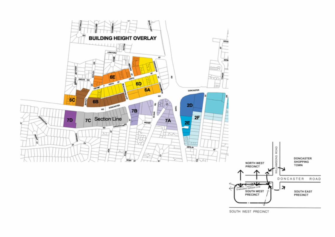

104/105>
Intersection of Doncaster, Williamsons and Tram Roads
OBJECTIVE DESIGN GUIDELINES
This intersection comprises the major cross roads and physicalcentre of Doncaster Hill Activity Centre with views to the cityskyline and Box Hill. The intersection forms part of the majorarterial road networks in the municipality, with access from theintersection to the Eastern Freeway, CBD and Box Hill ActivityCentre. Doncaster Road is the municipality’s main east westarterial road and major bus route.
The intersection will include the upgrading work associated withthe development of the proposed Doncaster Boulevard.
VISION STATEMENT
The Strategy supports the provision of iconic artwork at theintersection which:• defines its significance as the major cross roads and
physical centre of the Doncaster Hill Activity Centre;• creates a focal point of iconic status for Doncaster Hill
Activity Centre visible from all directions;• visually unifies the four corners of the intersection; and• preserves the street level pedestrian focus and retains views
along Doncaster Road.
It is envisaged that this intersection will have greatly increasedpedestrian safety and amenity, better connecting all precinctsabutting the Doncaster Road, Williamsons and Tram Roadsintersection.
OBJECTIVES AND GUIDELINES
In assessing proposed development and its likely impact andcontribution to the intersection, consideration will be given towhether proposals address the objectives and guidelinesoutlined below.
> Provide impetus to the development of Doncaster Hill through the introduction of a major piece of people-focused artwork integrated with Doncaster Hill.
> The intersection will embody the stated Doncaster Hill Design Principles of Ecologically Sustainable Design, equal access, contemporary expression, integration and diversity.
> Key corner sites abutting the intersection should be characterised by landmark developments which properly address the intersection and the proposed iconic element.
> Create an integrated intersection through the use of significant artwork and design.> Investigate the removal of left-hand turn lanes at the intersection.
1. Built Form
To encourage the development of an iconic artworkwhich reduces the visual scale of the majorintersection and visually links the separate corners.
2. Boulevard Character
To create artwork of iconic status on the DoncasterBoulevard.

106/107>
OBJECTIVE DESIGN GUIDELINES
> Pedestrian generating and retail activities should be encouraged at street level along Doncaster Boulevard, Williamsons and Tram Road Boulevards.
> Provide an accessible, pedestrian focused area around the Doncaster Boulevard, Williamsons and Tram Road intersection.
> The area will incorporate direct links to the buildings and pavements flanking the intersection.
> Design the iconic artwork so as to preserve existing vistas along Doncaster Road through the intersection and to Box Hill.
> Support and maintain a consistent planting strip in support of Doncaster Boulevard linking the seven area precincts.> Canopy trees are to be planted where appropriate.
3. Activated Street Frontage
To achieve activated street frontages to the proposedBoulevards.
4. Pedestrian Links
To provide positive pedestrian links across thephysical barrier of the Williamsons Road andDoncaster Boulevard intersection.
To integrate the pedestrian precincts created withineach of the development precincts flanking theintersection.
5. Vistas
To retain vistas to the City along Doncaster Road andto Box Hill.
6. Landscape
To create a healthy landscape environment inDoncaster Hill.