Tucson’s Early Streetscapes: 1775-1912
8
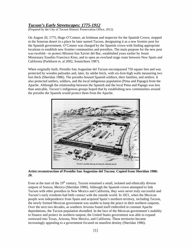
[1] Tucson’s Early Streetscapes: 1775-1912 (Prepared by the City of Tucson Historic Preservation Office, 2012) On August 20, 1775, Hugo O’Connor, an Irishman and inspector for the Spanish Crown, stopped in the Sonoran desert in a place he later named Tucson, designating it as a new frontier post for the Spanish government. O’Connor was charged by the Spanish crown with finding appropriate locations to establish new frontier communities and presidios. The main purpose for the new post was twofold—to protect Mission San Xavier del Bac, established years earlier by Jesuit Missionary Eusebio Francisco Kino, and to open an overland stage route between New Spain and California (Parkhurst et. al 2002, Sonnichsen 1987). When originally built, Presidio San Augustine del Tucson encompassed 750 square feet and was protected by wooden palisades and, later, by adobe brick, with six-foot-high walls measuring two feet thick (Sheridan 1986). The presidio housed Spanish soldiers, their families, and settlers. It also protected settlers, soldiers, and the local indigenous population (Pima and Papago) from the Apache. Although the relationship between the Spanish and the local Pima and Papago was less than amicable, Tucson’s indigenous groups hoped that by establishing new communities around the presidio the Spanish would protect them from the Apache. Artist reconstruction of Presidio San Augustine del Tucson. Copied from Sheridan 1986: 20. Even at the start of the 19 th century, Tucson remained a small, isolated and ethnically diverse outpost of Sonora, Mexico (Sheridan 1986). Although the Spanish crown attempted to link Tucson with other presidios in New Mexico and California, they were never truly successful and Tucson’s early residents had little contact with the outside world. In 1821, when the Mexican people won independence from Spain and acquired Spain’s northern territory, including Tucson, the newly formed Mexican government was unable to keep the peace in their northern outposts. Over the next two decades, as southern Arizona found itself embroiled in constant Apache depredations, the Tucson population dwindled. In the face of the Mexican government’s inability to finance and protect its northern outpost, the United States government was able to expand westward into Texas, Arizona, New Mexico, and California. These territories became increasingly appealing to a government focused on manifest destiny (Sheridan 1986).
Transcript of Tucson’s Early Streetscapes: 1775-1912
[1]
Tucson’s Early Streetscapes: 1775-1912 (Prepared by the City of Tucson Historic Preservation Office, 2012) On August 20, 1775, Hugo O’Connor, an Irishman and inspector for the Spanish Crown, stopped in the Sonoran desert in a place he later named Tucson, designating it as a new frontier post for the Spanish government. O’Connor was charged by the Spanish crown with finding appropriate locations to establish new frontier communities and presidios. The main purpose for the new post was twofold—to protect Mission San Xavier del Bac, established years earlier by Jesuit Missionary Eusebio Francisco Kino, and to open an overland stage route between New Spain and California (Parkhurst et. al 2002, Sonnichsen 1987). When originally built, Presidio San Augustine del Tucson encompassed 750 square feet and was protected by wooden palisades and, later, by adobe brick, with six-foot-high walls measuring two feet thick (Sheridan 1986). The presidio housed Spanish soldiers, their families, and settlers. It also protected settlers, soldiers, and the local indigenous population (Pima and Papago) from the Apache. Although the relationship between the Spanish and the local Pima and Papago was less than amicable, Tucson’s indigenous groups hoped that by establishing new communities around the presidio the Spanish would protect them from the Apache.
Artist reconstruction of Presidio San Augustine del Tucson. Copied from Sheridan 1986: 20. Even at the start of the 19th century, Tucson remained a small, isolated and ethnically diverse outpost of Sonora, Mexico (Sheridan 1986). Although the Spanish crown attempted to link Tucson with other presidios in New Mexico and California, they were never truly successful and Tucson’s early residents had little contact with the outside world. In 1821, when the Mexican people won independence from Spain and acquired Spain’s northern territory, including Tucson, the newly formed Mexican government was unable to keep the peace in their northern outposts. Over the next two decades, as southern Arizona found itself embroiled in constant Apache depredations, the Tucson population dwindled. In the face of the Mexican government’s inability to finance and protect its northern outpost, the United States government was able to expand westward into Texas, Arizona, New Mexico, and California. These territories became increasingly appealing to a government focused on manifest destiny (Sheridan 1986).
[2]
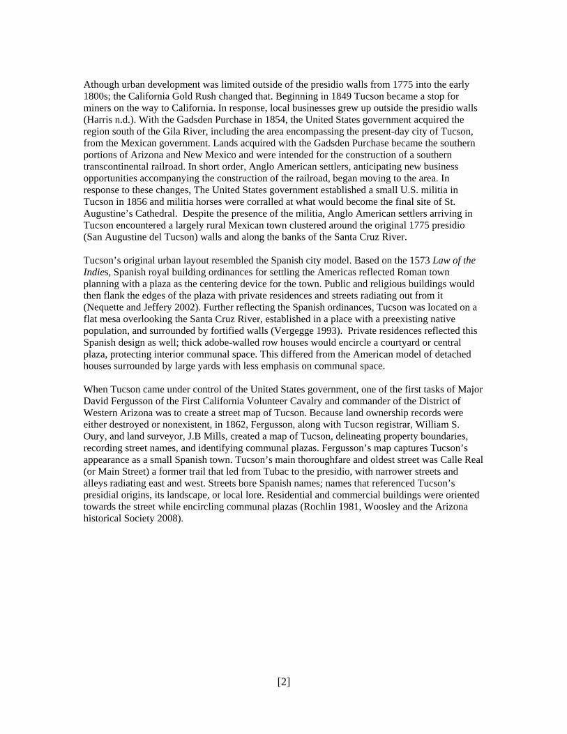
Athough urban development was limited outside of the presidio walls from 1775 into the early 1800s; the California Gold Rush changed that. Beginning in 1849 Tucson became a stop for miners on the way to California. In response, local businesses grew up outside the presidio walls (Harris n.d.). With the Gadsden Purchase in 1854, the United States government acquired the region south of the Gila River, including the area encompassing the present-day city of Tucson, from the Mexican government. Lands acquired with the Gadsden Purchase became the southern portions of Arizona and New Mexico and were intended for the construction of a southern transcontinental railroad. In short order, Anglo American settlers, anticipating new business opportunities accompanying the construction of the railroad, began moving to the area. In response to these changes, The United States government established a small U.S. militia in Tucson in 1856 and militia horses were corralled at what would become the final site of St. Augustine’s Cathedral. Despite the presence of the militia, Anglo American settlers arriving in Tucson encountered a largely rural Mexican town clustered around the original 1775 presidio (San Augustine del Tucson) walls and along the banks of the Santa Cruz River. Tucson’s original urban layout resembled the Spanish city model. Based on the 1573 Law of the Indies, Spanish royal building ordinances for settling the Americas reflected Roman town planning with a plaza as the centering device for the town. Public and religious buildings would then flank the edges of the plaza with private residences and streets radiating out from it (Nequette and Jeffery 2002). Further reflecting the Spanish ordinances, Tucson was located on a flat mesa overlooking the Santa Cruz River, established in a place with a preexisting native population, and surrounded by fortified walls (Vergegge 1993). Private residences reflected this Spanish design as well; thick adobe-walled row houses would encircle a courtyard or central plaza, protecting interior communal space. This differed from the American model of detached houses surrounded by large yards with less emphasis on communal space. When Tucson came under control of the United States government, one of the first tasks of Major David Fergusson of the First California Volunteer Cavalry and commander of the District of Western Arizona was to create a street map of Tucson. Because land ownership records were either destroyed or nonexistent, in 1862, Fergusson, along with Tucson registrar, William S. Oury, and land surveyor, J.B Mills, created a map of Tucson, delineating property boundaries, recording street names, and identifying communal plazas. Fergusson’s map captures Tucson’s appearance as a small Spanish town. Tucson’s main thoroughfare and oldest street was Calle Real (or Main Street) a former trail that led from Tubac to the presidio, with narrower streets and alleys radiating east and west. Streets bore Spanish names; names that referenced Tucson’s presidial origins, its landscape, or local lore. Residential and commercial buildings were oriented towards the street while encircling communal plazas (Rochlin 1981, Woosley and the Arizona historical Society 2008).
[3]
Reconstruction of Fergusson’s 1862 Street Map of Tucson. Copied from Sheridan 1986:61.
Upon arrival in Tucson, the early generations of Anglo American settlers adopted local architectural styles and expressions and continued to occupy an area centered on the presidio and Calle Real. This model continued to afford the best protection from the threat of Apache attacks. Despite Apache attacks, however, Tucson continued to attract new settlers. Many of these settlers who came to Tucson in the late 1860s and early 1870s saw an opportunity to get rich through various business and mining ventures, but also saw settlement as an opportunity to bring “civilization” to Tucson. They linked their ability to get rich and Tucson’s path towards progress to improving local infrastructure, including improving or creating local streets. Tucson’s streets were a cause of concern for many. Pioneer and businessman Samuel Hughes noted that “streets were so cut up by ravines that a wagon could not get through” (Sonnichsen 1987). Moreover, with no department of sanitation, dead animals often rotted on the street for days before being removed. John Bourke, who served with General Crook remarked that the unsanitary street conditions led to the local method of giving visitors directions via such city landmarks as manure piles and dead burros. None of this helped Tucson dispel the widely-held notion that the city was a dirty and unsanitary town. Indeed, California journalist, J. Ross Browne, who visited Tucson, described the city as “a paradise of devils” where rampant murder and drunkenness were the
[4]
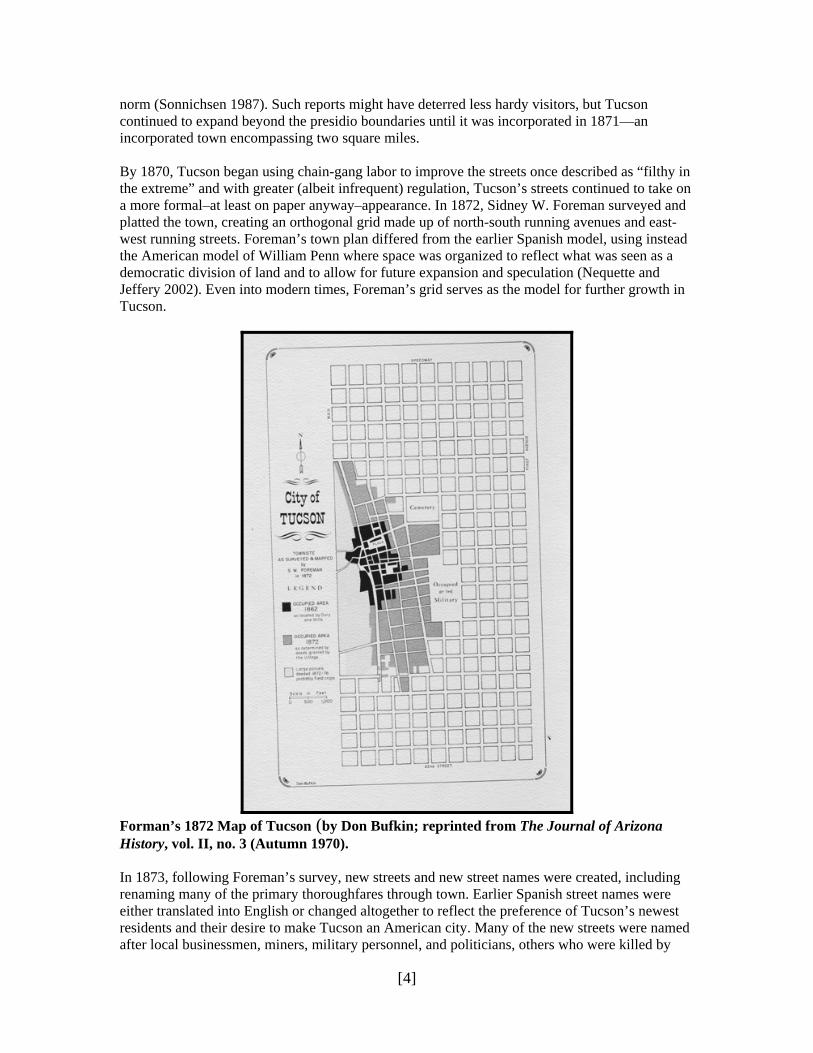
norm (Sonnichsen 1987). Such reports might have deterred less hardy visitors, but Tucson continued to expand beyond the presidio boundaries until it was incorporated in 1871—an incorporated town encompassing two square miles. By 1870, Tucson began using chain-gang labor to improve the streets once described as “filthy in the extreme” and with greater (albeit infrequent) regulation, Tucson’s streets continued to take on a more formal–at least on paper anyway–appearance. In 1872, Sidney W. Foreman surveyed and platted the town, creating an orthogonal grid made up of north-south running avenues and east-west running streets. Foreman’s town plan differed from the earlier Spanish model, using instead the American model of William Penn where space was organized to reflect what was seen as a democratic division of land and to allow for future expansion and speculation (Nequette and Jeffery 2002). Even into modern times, Foreman’s grid serves as the model for further growth in Tucson.
Forman’s 1872 Map of Tucson (by Don Bufkin; reprinted from The Journal of Arizona History, vol. II, no. 3 (Autumn 1970). In 1873, following Foreman’s survey, new streets and new street names were created, including renaming many of the primary thoroughfares through town. Earlier Spanish street names were either translated into English or changed altogether to reflect the preference of Tucson’s newest residents and their desire to make Tucson an American city. Many of the new streets were named after local businessmen, miners, military personnel, and politicians, others who were killed by
[5]
Apaches were honored with streets bearing their name. While few streets were named after local Mexican American pioneers, even fewer were named after women and those that were, referenced women of “loose morals.” Moreover, despite a modest population of Chinese businessmen, Tucson’s Chinese community was not recognized with corresponding street names. While it is believed that Foreman was likely responsible for many of Tucson’s new street names, Samuel Hughes and businessman William Osborne have also been credited with naming or renaming Tucson’s streets after influential friends and those killed by Apache Indians (Scott 1985, Rochlin 1980, Arizona Historical Society 2011). Despite the formalization of Tucson’s streetscape, streets continued to be dusty, unlit, and without sidewalks and sanitation continued to be a problem. By 1879, public transportation was introduced to Tucson in the form of horse-drawn carriages, but was accompanied by its own sanitation problems. By the following year however, Tucson would witness the greatest change to its urban layout. In 1880, the arrival of the railroad significantly altered the demographic and physical development of this historically Mexican frontier town (Parkhurst et. al. 2002). Not only did the location of the railroad influence the direction of Tucson’s early urban development and connect Tucson to the rest of the U.S. and Mexico, but it brought more Anglo American settlers, most notably Anglo American women. The increase in the number of Anglo American women led to a decrease in the number of Anglo-Mexican marriages. Over time this socio-economic separation led to a further decrease in ethnic cooperation and the separation of ethnic populations into distinct neighborhoods. Soon, Tucson’s Mexican American population began migrating to areas south of present-day Broadway Boulevard and west of Stone Avenue, while Tucson’s Anglo American population expanded east and north of Broadway Boulevard (Sheridan 1986, Parkhurst et. al 2002). Tucson’s street names reflected this socio-economic change as well; streets bearing the names of prominent Anglo Americans tended to mark thoroughfares through the northern and eastern sections of the city, while streets bearing the names of prominent Mexican Americans were found throughout the western and southern sections of Tucson. The arrival of the railroad reinforced many Tucsonan’s desire to refashion Tucson as a “progressive” and distinctly American city. Besides the growing socio-economic division amongst Tucson’s citizenry, Eastern architectural styles and materials were also introduced into the desert setting. Many of the old adobes were torn down or replaced with large Victorian-style homes, or remodeled to reflect a more American appearance. City streets mirrored this change as well. By 1883, electric streetlamps hung suspended over city streets, and by 1898, many commercial buildings were fronted by sidewalks, and a mule-and-horse drawn street railway carried the public across town (Woosley and the Arizona Historical Society 2008). Shortly after the turn of the 20th century, Tucson’s streetscape began another rapid change, led in part by Tucson’s new mayor, General Levi H Manning. Manning set to work passing and enforcing new edicts that would curb or limit many of the vices for which Tucson was well known. In addition to laws limiting gambling, drinking, and prostitution, Manning further cleaned up Tucson’s streets, put vagrants to work oiling and repairing city streets, and, in a further effort to clean up the city’s reputation, outfitted the police force with new uniforms. A year after taking office Mayor Manning made good on his campaign promise of bringing the electric streetcar to Tucson. On 1 June 1906, mule-and-horse drawn cars were replaced with two electric streetcars that traveled from the University of Arizona, through the downtown commercial district, ending at Elysian Grove (Tucson Citizen, 1 June 1906).

[6]
Historical Photograph of Road Repairs along Main Avenue, late 1880s. (Courtesy of the Arizona Historical Society, Tucson, photograph number: B109406). By the time Manning finished his term as mayor, the city boasted a new and spacious hotel-the Santa Rita Hotel- and an electric streetcar. Despite the big-city appearance of the hotel and public transportation, Tucson was still a sparsely populated place with persistently dusty streets. Only the main thoroughfares-Stone Avenue and Congress Street-benefited from dust-control programs, usually water trucks to spray down the great plumes of dust brought up by the streetcars and the newly popular automobile. Finally in 1911, paving began on Stone Avenue and for many years after, only the main commercial areas had surfaced streets (Sonnichsen 1987). It was not until the 1920s that any formal dust-control programs extended to streets outside the downtown area. Upon Arizona statehood in 1912, Tucson was well on its way to achieving a common ambition for settlements in the West: becoming an American city. During the 19th and early 20th centuries town building and planning was an important facet of Westward migration. Residents of new settlements envisioned a future in which their communities would become urban centers. Streets became a main focal point of these new settlements, especially the primary routes through a community. The streets, coupled with the commercial and residential buildings that graced them, were the means by which communities not only provided an identity for themselves but the means by which they projected their identify to others (Longstreth 1987).
[7]
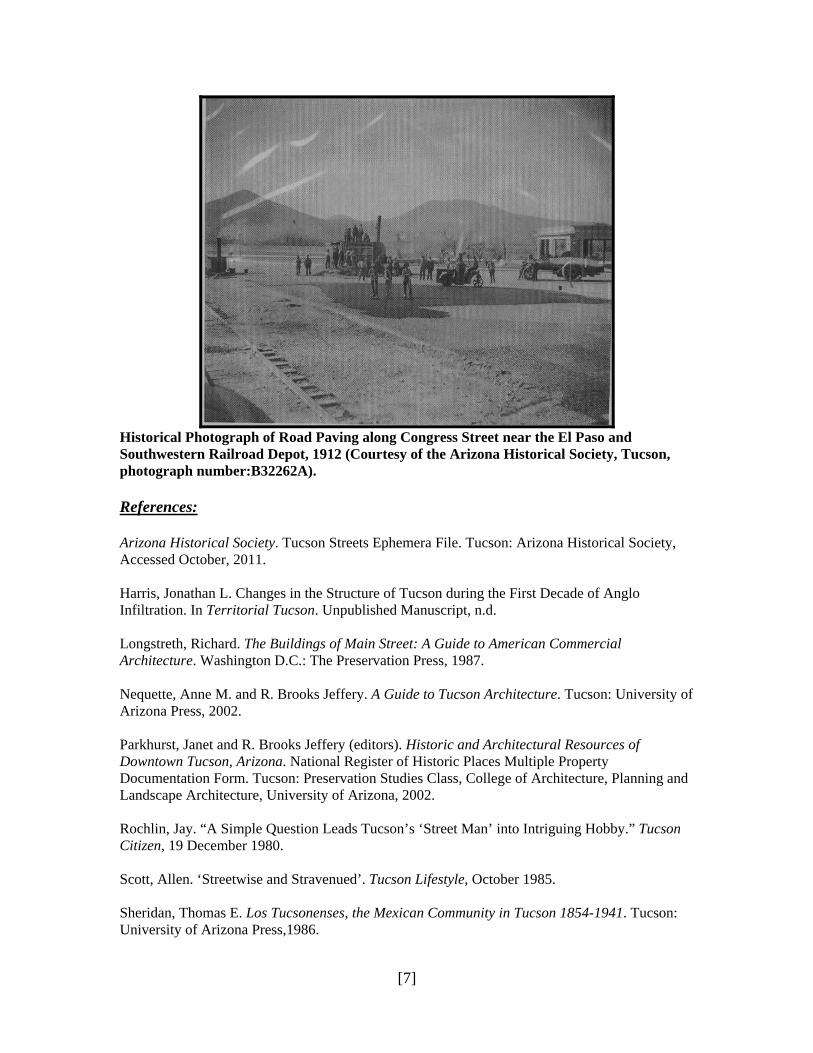
Historical Photograph of Road Paving along Congress Street near the El Paso and Southwestern Railroad Depot, 1912 (Courtesy of the Arizona Historical Society, Tucson, photograph number:B32262A). References: Arizona Historical Society. Tucson Streets Ephemera File. Tucson: Arizona Historical Society, Accessed October, 2011. Harris, Jonathan L. Changes in the Structure of Tucson during the First Decade of Anglo Infiltration. In Territorial Tucson. Unpublished Manuscript, n.d. Longstreth, Richard. The Buildings of Main Street: A Guide to American Commercial Architecture. Washington D.C.: The Preservation Press, 1987. Nequette, Anne M. and R. Brooks Jeffery. A Guide to Tucson Architecture. Tucson: University of Arizona Press, 2002. Parkhurst, Janet and R. Brooks Jeffery (editors). Historic and Architectural Resources of Downtown Tucson, Arizona. National Register of Historic Places Multiple Property Documentation Form. Tucson: Preservation Studies Class, College of Architecture, Planning and Landscape Architecture, University of Arizona, 2002. Rochlin, Jay. “A Simple Question Leads Tucson’s ‘Street Man’ into Intriguing Hobby.” Tucson Citizen, 19 December 1980. Scott, Allen. ‘Streetwise and Stravenued’. Tucson Lifestyle, October 1985. Sheridan, Thomas E. Los Tucsonenses, the Mexican Community in Tucson 1854-1941. Tucson: University of Arizona Press,1986.

[8]
Sonnichsen, C.L. Tucson, the Life and Times of an American City. Norman: University of Oklahoma Press, 1987. Tucson Citizen "Electric Cars Running in Old Pueblo" 1 June 1906. Vergegge, Nina. Transformations of Spanish Urban Landscapes in the American Southwest, 1821-1900. Journal of the Southwest, winter 1993. Woosley, Anne I. and the Arizona Historical Society. Early Tucson. San Francisco: Arcadia Publishing, 2008.