UPPER LACHLAN SHIRE HERITAGE STUDY Final Revised 2010 · Upper Lachlan Local Environmental Plan...
87
Transcript of UPPER LACHLAN SHIRE HERITAGE STUDY Final Revised 2010 · Upper Lachlan Local Environmental Plan...


Upper Lachlan Shire Community Heritage Study 2007-2008. 2
CONTENTS LIST OF FIGURES .................................................................................................................................. 7
ACKNOWLEDGMENTS .......................................................................................................................... 11
INTRODUCTION .................................................................................................................................. 11
Upper Lachlan Local Environmental Plan 2010 – Schedule 5, Environmental Heritage. 14 Upper Lachlan Shire ~ Heritage Assessment .......................................................................... 14 Heritage in New South Wales ..................................................................................................... 15 Legislation and Heritage Registers ............................................................................................. 15 Assessing Heritage Significance .................................................................................................. 16 Listing on the NSW State Heritage Register ............................................................................ 16 Local Heritage Listing .................................................................................................................. 16 The Natural Environment ........................................................................................................... 17 The Built Environment ................................................................................................................ 17 Aboriginal Heritage ...................................................................................................................... 18 Archaeological Heritage ............................................................................................................... 19 HERITAGE ITEMS ~ UPPER LACHLAN SHIRE ..................................................................................... 20
UPPER LACHLAN SHIRE ~ THEMATIC HISTORY ................................................................................ 20
Upper Lachlan Shire ..................................................................................................................... 20 Aboriginal – European Contact ................................................................................................. 21 Land Holdings ............................................................................................................................... 21 1829 Limits of Location............................................................................................................... 22 Land Title Systems ........................................................................................................................ 23 Exploration and Settlement......................................................................................................... 24 Mining ............................................................................................................................................. 26 Agriculture ..................................................................................................................................... 26 Development of the Railways ..................................................................................................... 27 Churches and Burial Grounds .................................................................................................... 31 UPPER LACHLAN SHIRE ~ NATURAL HERITAGE ............................................................................... 33
Wombeyan Caves Area ................................................................................................................ 33 Tarlo River National Park ........................................................................................................... 34 Lampton Creek Ornithological Area ......................................................................................... 37 Fossil Leaf Beds ............................................................................................................................ 38 Mundoonen Nature Reserve ....................................................................................................... 38 Rowes Lagoon [also referred to as Roses Lagoon] ................................................................. 39 TOWNS AND VILLAGES OF UPPER LACHLAN SHIRE ........................................................................... 41
BIGGA ............................................................................................................................................. 41 Bigga Public School ...................................................................................................................... 42 All Saint’s Anglican Church, Bigga. ........................................................................................... 42 Uniting Church, Bigga .................................................................................................................. 43 Bigga Catholic Church ................................................................................................................. 44 The Federal Hotel ......................................................................................................................... 44 Bigga War Memorial Hall ............................................................................................................ 45 Olympia Café, Bigga ..................................................................................................................... 46 Bigga General Cemetery .............................................................................................................. 46 BINDA ............................................................................................................................................. 47 Funny Hill ........................................................................................................................................ 48 Funny Hill, National School, Binda. ......................................................................................... 48 The Binda Mill ............................................................................................................................... 50 St. James’ Anglican Church, Binda, c.1864. .............................................................................. 51 Binda Cemetery ............................................................................................................................. 52 Old Salisbury Private Cemetery .................................................................................................. 53

Upper Lachlan Shire Community Heritage Study 2007-2008. 3
Rose Cottage, Binda. .................................................................................................................... 54 Former Post Office and Store, Binda. ....................................................................................... 54 Markdale Homestead ........................................................................................................................ 56 St. Andrew's Anglican Church .................................................................................................... 57 Kangaloolah Creek Bridge ........................................................................................................... 57 BREADALBANE.............................................................................................................................. 59 Inns at Breadalbane ...................................................................................................................... 60 Rosythe .............................................................................................................................................. 61 Sweetwood Lea .................................................................................................................................. 65 Hotel Breadalbane ............................................................................................................................. 67 Breadalbane Public School .......................................................................................................... 68 St. Brigid’s Catholic Church ........................................................................................................ 69 Raeburn Homestead and Stables ................................................................................................ 71 Church of St Silas, Breadalbane .................................................................................................. 71 COLLECTOR ................................................................................................................................... 73 Wheat Sheaf Inn ............................................................................................................................... 74 Bushranger Hotel, Collector. ........................................................................................................... 74 Collector Inn (est. 1824). ................................................................................................................. 76 Collector Public School ............................................................................................................... 76 Collector Memorial Hall .............................................................................................................. 77 Uniting [Wesleyan] Church, Collector. ...................................................................................... 77 Uniting Church Cemetery, Collector. ........................................................................................ 78 St. Bartholomew’s Catholic Church, Collector. ....................................................................... 81 All Saints Anglican Church, Collector. ...................................................................................... 81 Anglican Cemetery, Collector. .................................................................................................... 82 CROOKED CORNER ..................................................................................................................... 87 Five Mile Tree Public School ...................................................................................................... 87 CROOKWELL ................................................................................................................................. 88 Wheat Sheaf Inn ruins, Crookwell. ................................................................................................ 88 The Millhouse Inn ............................................................................................................................ 89 Crookwell Post Office ................................................................................................................. 92 Gundowringa ................................................................................................................................. 93 Crookwell Memorial Hall ............................................................................................................ 94 Commonwealth Bank, Crookwell. ............................................................................................. 94 Crookwell Masonic Hall .............................................................................................................. 95 Crookwell District Hospital ........................................................................................................ 95 Court House Complex, Crookwell ............................................................................................ 96 Bank of New South Wales .......................................................................................................... 97 Goulburn Street Commercial Buildings .................................................................................... 98 Lynam’s Cafe ................................................................................................................................. 98 Pedley’s Building ........................................................................................................................... 99 Commercial Building 1914 .......................................................................................................... 99 The Criterion Hotel ........................................................................................................................ 100 Bryant’s Bakery ............................................................................................................................ 100 Mendl Thompson Associates; Catherine’s Cafe Bakery ....................................................... 101 The Goldsworth Theatre [Crown Theatre] ............................................................................ 101 Commercial Hotel [formerly the Horse and Hound Hotel]. ........................................................... 102 Crookwell Hotel Motel .............................................................................................................. 102 Stephenson's Mill ........................................................................................................................ 103 Crookwell Iron Mine .................................................................................................................. 104 Education in Crookwell ............................................................................................................. 107 Crookwell Public School ........................................................................................................... 107 St Mary’s Primary School........................................................................................................... 108 St. Mary’s Catholic Church ........................................................................................................ 109 St Andrew’s Presbyterian Church ............................................................................................ 110 St Bartholomew’s Church of England, Crookwell ................................................................ 110

Upper Lachlan Shire Community Heritage Study 2007-2008. 4
Crookwell General Cemetery .................................................................................................... 111 Crookwell River Bridge .............................................................................................................. 113 Crookwell Railway Station and Yards ...................................................................................... 114 Montrose ......................................................................................................................................... 115 Normanton ..................................................................................................................................... 116 St. Stephen’s Church of England, Pejar. ................................................................................. 117 DALTON ....................................................................................................................................... 118 Dalton Public Hall ...................................................................................................................... 118 Dalton General Cemetery .......................................................................................................... 118 Dalton Public School ................................................................................................................. 119 Royal Hotel, Dalton .................................................................................................................... 120 Eschol, Dalton ............................................................................................................................... 120 Dalton Uniting Church .............................................................................................................. 121 Odd Fellow’s Hall [former], Dalton. ....................................................................................... 121 St. Matthew’s Anglican Church, Dalton. ................................................................................. 122 GRABBEN GULLEN .................................................................................................................... 123 Albion Hotel ................................................................................................................................ 123 GUNNING .................................................................................................................................... 124 Frankfield ....................................................................................................................................... 124 Frankfield Hotel .......................................................................................................................... 126 Collingwood ..................................................................................................................................... 127 Claytons of Baltinglass ................................................................................................................. 129 Boureong ......................................................................................................................................... 136 Gunning Pastoral, Agricultural and Industrial Society ......................................................... 137 Upper Lachlan Shire Office and Chambers ........................................................................... 138 Masonic Lodge [former] ............................................................................................................ 138 Gunning Public School .............................................................................................................. 139 Cottage, 11 Collector Road, Gunning ..................................................................................... 139 Former Butcher’s Shop, cnr. Saxby and Warrataw Streets .................................................. 140 Do Duck Inn - Formerly Aratula Inn, 22 Hume Street......................................................... 140 Pye Cottage, 121 Yass Street ..................................................................................................... 141 Shop, 81 Yass Street, Gunning. ............................................................................................... 141 Bailey’s Garage ............................................................................................................................ 142 Coronation Theatre .................................................................................................................... 142 Caxton House .............................................................................................................................. 143 Caxton Cottage ............................................................................................................................ 143 National Bank of Australia ........................................................................................................ 144 Manufacturers Mutual Insurance Building [Former] ............................................................ 144 Telegraph Hotel, Yass Street ......................................................................................................... 144 St. Edmund’s Anglican Church ................................................................................................ 145 St. Edmund’s Anglican Church Rectory ................................................................................. 145 Gunning Post Office .................................................................................................................. 146 Gunning District Soldiers Memorial ........................................................................................ 147 Gunning Court House, Police Station and Lock Up ............................................................ 147 London House ............................................................................................................................ 149 Gunning Railway Station and Yard Group ............................................................................. 150 Gunning Station Master’s Residence [former] ....................................................................... 151 Fish River Water Supply ............................................................................................................ 151 Gunning Catholic Cemetery ..................................................................................................... 152 Uniting Church [former Wesleyan Methodist] ..................................................................... 152 St. Francis Xavier’s Catholic Presbytery and Church ............................................................ 152 St. Francis Xavier’s Catholic Convent Building ..................................................................... 153 St. Francis Xavier’s Old Catholic School ................................................................................ 153 Gunning General Cemetery ...................................................................................................... 154 LAGGAN ....................................................................................................................................... 157 Laggan Hotel ............................................................................................................................... 157

Upper Lachlan Shire Community Heritage Study 2007-2008. 5
Laggan Memorial Hall ................................................................................................................ 158 Willow Vale Mill .......................................................................................................................... 158 Presbyterian Church ................................................................................................................... 159 All Saint’s Anglican Church ...................................................................................................... 159 The Cemetery, Laggan. .............................................................................................................. 159 St. Andrew’s Catholic Church .................................................................................................. 160 Laggan Public School ................................................................................................................. 160 TUENA .......................................................................................................................................... 161 The Book Keeper’s Cottage ...................................................................................................... 162 The Goldfield’s Inn ........................................................................................................................ 163 Parson’s General Store ............................................................................................................... 163 A Glimpse of Life and Death at Tuena................................................................................... 163 Tuena Public School ................................................................................................................... 164 St Mary's Catholic Church ......................................................................................................... 164 St. Mark's Anglican Church ....................................................................................................... 165 St. Margaret's Presbyterian Church .......................................................................................... 165 Culverts, Tuena - Abercrombie Road, ..................................................................................... 166 TARALGA ...................................................................................................................................... 167 Orchard Street, Taralga, NSW. ................................................................................................. 168 Taralga Post Office ..................................................................................................................... 169 St Luke’s Anglican Church ........................................................................................................ 170 Hotel Taralga [former Richlands Hotel] ................................................................................. 171 Miss Crokes’ Tearooms and Tom Maloney’s Residence, Orchard Street ......................... 171 Taralga Courthouse [former]. ................................................................................................... 172 Royal Hotel [former], Taralga ................................................................................................... 173 Whiting’ Store .............................................................................................................................. 173 Argyle Inn .................................................................................................................................... 173 Goodhew Bros. Store ................................................................................................................. 174 Taralga War Memorial ................................................................................................................ 174 Taralga Memorial Hall ................................................................................................................ 176 Wesleyan Methodist Church ..................................................................................................... 176 Taralga Public School ................................................................................................................. 176 Taralga Additional Items ........................................................................................................... 177 Overseer’s House, [Denning], 31 Macarthur Street, Taralga. ............................................. 177 Convict Flogging Tree Site, Taralga. ........................................................................................ 178 Bank of New South Wales, Taralga ......................................................................................... 180 Taralga Showground - Agricultural, Pastoral and Horticultural Association .................... 181 Church of Christ the King, Taralga ......................................................................................... 182 Stonequarry General Cemetery ................................................................................................. 185 Taralga Railway Station .............................................................................................................. 186 YALBRAITH .................................................................................................................................. 186 Yalbraith Presbyterian Church [former] .................................................................................. 186 GOLSPIE ....................................................................................................................................... 187 School of Arts, Golspie ............................................................................................................. 188 St Joseph’s Catholic Church ...................................................................................................... 188 St Mark’s Anglican Church ....................................................................................................... 188 BANNABY ..................................................................................................................................... 189 Hillasmount [Hillas Farm and Outbuildings] .......................................................................... 189 Bunnaby Homestead .................................................................................................................. 189 Bannaby Shearing Shed .............................................................................................................. 190 St Matthew’s Anglican Church and Cemetery, Bannaby .................................................... 190 Richlands Estate .......................................................................................................................... 195 Strathaird School. ........................................................................................................................ 198 CHATSBURY ................................................................................................................................. 199 Christ Church Anglican Cemetery ........................................................................................... 200 BURRA LAKE ............................................................................................................................... 201
Upper Lachlan Shire Community Heritage Study 2007-2008. 6
Burra Lake School ...................................................................................................................... 201 CULLERIN ..................................................................................................................................... 203 TARLO ........................................................................................................................................... 204 MYRTLEVILLE ............................................................................................................................. 205 Myrtleville Flour Mill .................................................................................................................. 205 Hillcrest ........................................................................................................................................ 205 Myrtleville School ....................................................................................................................... 205 ROSLYN ........................................................................................................................................ 205 Roslyn War Memorial Hall ........................................................................................................ 205 CURRAWEELA .............................................................................................................................. 205 St John’s Anglican Church, Curraweela .................................................................................. 205 POMEROY ..................................................................................................................................... 206 Pomeroy Mill ............................................................................................................................... 207 DISCLAIMER ...................................................................................................................................... 208

Upper Lachlan Shire Community Heritage Study 2007-2008. 7
LIST OF FIGURES Figure 1: Map of Upper Lachlan Shire ........................................................................................................................ 13 Figure 2: Aveling & Porter steam truck of John Willis & Sons, Steam Brick Works, Crookwell, NSW.
[SLNSW]. .............................................................................................................................................................. 27 Figure 3: Tarlo River National Park. ............................................................................................................................ 35 Figure 4: Fossil Leaf Bed, Dalton NSW. ..................................................................................................................... 38 Figure 5: Bigga Post Office, c.1900. ........................................................................................................................... 41 Figure 6: Bigga Public School established in 1884..................................................................................................... 42 Figure 7: All Saint’s Anglican Church, Bigga. ............................................................................................................. 43 Figure 8: Foundation stone of All Saint’s Anglican Church, Bigga, ....................................................................... 43 Figure 9: Uniting [formerly Methodist] Church, Bigga. ............................................................................................ 44 Figure 10: Federal Hotel, Bigga, erected 1936. ........................................................................................................... 45 Figure 11: Bigga War Memorial Hall significant for its 1950s architectural facade. ............................................. 45 Figure 12: Olympia Cafe, Bigga, established 1926. .................................................................................................... 46 Figure 13: ‘Binda Schoolhouse, 16th July 1870’. ......................................................................................................... 48 Figure 14: The National School, Funny Hill, 2008. .................................................................................................... 49 Figure 15: The Binda Mill .............................................................................................................................................. 51 Figure 16: St. James’ Anglican Church, Binda. ........................................................................................................... 52 Figure 17: Binda Cemetery, NSW. ............................................................................................................................... 52 Figure 18: Salisbury Cemetery ...................................................................................................................................... 53 Figure 19: Rose Cottage, Binda. ....................................................................................................................................... 54 Figure 20: Former post office and store c. 1870, Binda. .......................................................................................... 55 Figure 21: Binda Post Office operated from this building c. 1951. ........................................................................ 55 Figure 22: Markdale Homestead, near Binda. ................................................................................................................. 56 Figure 23: St Andrew’s Anglican Church, Markdale. ................................................................................................ 57 Figure 24: Bennett, E. J. Plan of 99 portions of land at the Third Bredalbane Plain, Mutmutbilly, Dairy Flats
etc. County of Argyle. 1856. .............................................................................................................................. 60 Figure 25: Notice in the Sydney Morning Herald, Tuesday 5th December 1848, p.3. ............................................... 62 Figure 26: Advertisement for William Riley’s Coach and Horses Inn to be opened 1st July 1853. ......................... 62 Figure 27: Coach and Horses Inn available for lease advertised in the Sydney Morning Herald, 24th October 1853.
................................................................................................................................................................................ 63 Figure 28: Rosythe, established as an inn c.1838 as the ‘Brisbane Arms’ or ‘Breadalbane Arms’ . ............................. 64 Figure 29: Sweetwood Lea 2008. ...................................................................................................................................... 66 Figure 30: Renewal of Publican’s Licence No. 2046, issued to John Hannan for the Breadalbane Hotel on 30th
June 1876. ............................................................................................................................................................. 66 Figure 31: Hotel Breadalbane, 2008, now a private residence. .................................................................................... 67 Figure 32: Sign ‘Public School 1876’ on the Old Breadalbane School, Old South Road. ................................. 68 Figure 33: Breadalbane Public School. ........................................................................................................................ 68 Figure 34: St Brigid’s Catholic Church, Breadalbane, NSW. ................................................................................... 69 Figure 35: John Alt, Breadalbane 1891. ....................................................................................................................... 72 Figure 36: Church of St Silas, Breadalbane. ................................................................................................................ 72 Figure 37: The original Wheat Sheaf Inn, Collector often mistakenly referred to as Murray's first homestead,
c.1829 which was located behind the Collector Inn, down towards the creek. ............................................. 74 Figure 38: The Collector Hotel photographed in 1937. ................................................................................................ 75 Figure 39: The Bushranger Hotel, Collector, 2007. ....................................................................................................... 75 Figure 40: The site of the original Collector Inn established c.1824, now the Collector Inn General Store. ........... 76 Figure 41: Collector Public School, Collector, NSW. ............................................................................................... 76 Figure 42: Collector Memorial Hall. ............................................................................................................................ 77 Figure 43: Uniting Church [Wesleyan Church] est. 1865, Collector, NSW. .......................................................... 77 Figure 44: Grave of Elizabeth Ann Granger, Uniting Church Cemetery, Collector, NSW. ............................... 78 Figure 45: Uniting Church Cemetery, Collector, NSW. ........................................................................................... 78 Figure 46: Diagram of headstones with inscriptions, Uniting Church Cemetery, Collector. .............................. 79 Figure 47: St. Bartholomew’s Catholic Church, Collector. ...................................................................................... 81 Figure 48: All Saints Anglican Church, Collector, NSW. ......................................................................................... 81 Figure 49: Anglican Cemetery, Collector, NSW. ....................................................................................................... 82 Figure 50: Diagram of headstones with inscriptions in the Anglican and Catholic Church Cemetery,
Collector, NSW. ................................................................................................................................................... 82 Figure 51: Five Mile Tree Public School, Crooked Corner. ..................................................................................... 87 Figure 52: Wheat Sheaf Inn ruins, Crookwell. ............................................................................................................... 88 Figure 53: The Millhouse Inn established in 1862 [now Spud Murphy’s Inn]. ............................................................ 89 Figure 54: Goulburn Street, Crookwell c. 1930. ........................................................................................................ 89 Figure 55: The Crookwell Grandstand, 1913. ............................................................................................................ 90 Figure 56: View of Crookwell c. 1930. ........................................................................................................................ 91 Figure 57: Crookwell Post Office, 1901. ..................................................................................................................... 92 Figure 58: Crookwell Post Office, 1930. ..................................................................................................................... 92 Figure 59: Crookwell Post Office, Goulburn Street. 2008. ...................................................................................... 93 Figure 60: Gundowringa Homestead. ............................................................................................................................. 93

Upper Lachlan Shire Community Heritage Study 2007-2008. 8
Figure 61: Crookwell Memorial Hall. .......................................................................................................................... 94 Figure 62: Commonwealth Bank building. ................................................................................................................. 94 Figure 63: Masonic Hall, Denison Street, Crookwell, est. 1927. ............................................................................. 95 Figure 64: Crookwell District Hospital ....................................................................................................................... 95 Figure 65: Crookwell’s first court house building, later used as the Police residence. ......................................... 96 Figure 66: The Court House, Crookwell. .................................................................................................................... 96 Figure 67: The former Bank of New South Wales, Crookwell. ............................................................................... 97 Figure 68: Goulburn Street, Crookwell, presents a variety of late Victorian style facades. ................................. 98 Figure 69: Lynam’s cafe building, Crookwell. ............................................................................................................ 98 Figure 70: Pedley’s Building, Goulburn Street. .......................................................................................................... 99 Figure 71: Commercial building, established 1914. ................................................................................................... 99 Figure 72: The Criterion Hotel, Goulburn Street, Crookwell. .................................................................................. 100 Figure 73: Bryant’s Bakery building, established 1890. ........................................................................................... 100 Figure 74: Group of commercial buildings Goulburn Street including Mendl Thompson Associates [left],
Catherine’s Cafe Bakery and Deli [right]. ....................................................................................................... 101 Figure 75: The former Goldsworth Theatre, also referred to as the ‘Crown Theatre’ c. 1947, and the
adjoining store now the Coin-Op. Laundrette, Crookwell. ......................................................................... 101 Figure 76: Commercial Hotel, formerly the Horse and Hound Hotel est. 1871. .......................................................... 102 Figure 77: Crookwell Hotel Motel, originally the Hotel Crookwell established in 1884. ...................................... 102 Figure 78: Stephenson’s Mill, Crookwell. .................................................................................................................. 103 Figure 79: Crookwell Iron Mine site, January 2009. ................................................................................................ 104 Figure 80: Crookwell Iron Mine site dam, January 2009. ....................................................................................... 105 Figure 81: An extant section of the bridge over the Crookwell River near Crookwell Iron Mine site ............ 105 Figure 82: Powder Magazine, Crookwell Iron Mine site, January 2009. .............................................................. 106 Figure 83: Tunnel at the Crookwell Iron Mine site, January 2009. ....................................................................... 106 Figure 84: Crookwell Public School........................................................................................................................... 107 Figure 85: Commonwealth Jubilee Celebrations, Crookwell District Rural School, Pageant, 1951. ............... 108 Figure 86: St Mary’s Primary School, Wade Street, Crookwell. ............................................................................. 108 Figure 87: View of the old St Mary’s Primary School. ............................................................................................ 109 Figure 88: St. Mary’s Catholic Church, Crookwell. ................................................................................................. 109 Figure 89: St Andrew’s Presbyterian Church, Colyer Street, Crookwell. ............................................................. 110 Figure 90: St. Bartholomew's Church of England ................................................................................................... 110 Figure 91: Crookwell General Cemetery. .................................................................................................................. 112 Figure 92: Crookwell River Bridge ............................................................................................................................. 113 Figure 93: Crookwell Railway Station. ....................................................................................................................... 114 Figure 94: Crookwell railway disused track and platform. ...................................................................................... 114 Figure 95: Montrose, the two-storey E.C. Manfred designed residence, erected for Charles Schroeder in 1887.
.............................................................................................................................................................................. 115 Figure 96: Normanton, an elegant Victorian country residence, erected in 1891. ................................................. 116 Figure 97: The side elevation of Normanton showing the sandstock additions, c.1920. ..................................... 116 Figure 98: Dalton Public Hall ..................................................................................................................................... 118 Figure 99: Dalton Public School building erected in 1878. .................................................................................... 119 Figure 100: Dalton Public School .............................................................................................................................. 119 Figure 101: The Royal Hotel, Dalton. .......................................................................................................................... 120 Figure 102: Dalton Uniting Church, Chapel Street, Dalton. .................................................................................. 121 Figure 103: Odd Fellows Hall, Dalton, NSW, now a private residence. .............................................................. 121 Figure 104: St Matthew’s Anglican Church, Dalton, NSW. ................................................................................... 122 Figure 105: The headstone of Joseph Dowling ....................................................................................................... 122 Figure 106: Post Office, Grabben Gullen, c. 1950. ................................................................................................. 123 Figure 107: The Albion Hotel, Grabben Gullen. ....................................................................................................... 123 Figure 108: Frankfield Homestead. ............................................................................................................................. 125 Figure 109: View from the verandah of Frankfield, 2009. ....................................................................................... 125 Figure 110: Frankfield Hotel, Gunning, NSW, est. c.1870. ....................................................................................... 126 Figure 111: Collingwood, near Gunning, NSW, c. 1836............................................................................................. 127 Figure 112: View from the verandah of Collingwood 2009. .................................................................................. 128 Figure 113: Portions 8a and 9a, 745 acres and 799 acres respectively, in the Parish of Gunning, County of
King 2 Edition c. 1883. ..................................................................................................................................... 130 Figure 114: The remains of a wall at the rear of the Baltinglass homestead. ......................................................... 132 Figure 115: Watercolour annotated - ‘A Sketch of Baltinglass by E. Goodridge Nov. 7 1866’. ...................... 133 Figure 116: Baltinglass on the bank of the Lachlan River at Gunning, NSW, 2002. ........................................... 133 Figure 117: The stone foundations of the front wall of the homestead. .............................................................. 134 Figure 118: Avenue of trees leading to the Baltinglass homestead. ....................................................................... 135 Figure 119: Baltinglass from the adjoining property granted to Elizabeth Aiken Woodhouse and occupied by
George Woodhouse. ......................................................................................................................................... 135 Figure 120: Boureong, Gunning NSW. ........................................................................................................................ 136 Figure 121: Upper Lachlan Shire Office and Chambers, Gunning. ...................................................................... 138 Figure 122: The former Masonic Lodge, Gunning. ................................................................................................ 138 Figure 123: Gunning Public School 2008. ................................................................................................................ 139
Upper Lachlan Shire Community Heritage Study 2007-2008. 9
Figure 124: Former Butcher’s Shop, cnr. Saxby and Warrataw Streets. ............................................................... 140 Figure 125: Aratula Inn, now known as the ‘Do Duck Inn’, Gunning, NSW. ..................................................... 140 Figure 126: Pye Cottage. .............................................................................................................................................. 141 Figure 127: Shop, 81 Yass Street, Gunning. ............................................................................................................. 141 Figure 128: Yass Street, Gunning, showing Bailey’s Garage and the former Coronation Theatre building. .. 142 Figure 129: Coronation Theatre building, Yass Street. ........................................................................................... 142 Figure 130: Caxton House, Yass Street, Gunning, NSW. ......................................................................................... 143 Figure 131: Caxton Cottage, Yass Street, Gunning, NSW. .................................................................................... 143 Figure 132: The former National Bank of Australia, Gunning. ............................................................................ 144 Figure 133: The Telegraph Hotel. .................................................................................................................................. 144 Figure 134: St. Edmund’s Anglican Church, Biala Street, Gunning. .................................................................... 145 Figure 135: St. Edmund’s Anglican Church Rectory, Gunning. ........................................................................... 145 Figure 136: Gunning Post Office, c.1905. ................................................................................................................ 146 Figure 137: Gunning Post Office, 2007. ................................................................................................................... 146 Figure 138: Gunning District Soldiers Memorial ..................................................................................................... 147 Figure 139: Gunning Court House, September, 1885, [SRNSW]. ........................................................................ 147 Figure 140: Gunning Courthouse Complex, 2007. .................................................................................................. 148 Figure 141: London House, Gunning, est. 1881. ..................................................................................................... 149 Figure 142a: London House, Gunning, at about the turn of the century. 121 ...................................................... 149 Figure 143: Gunning Railway Station. ....................................................................................................................... 150 Figure 144: Platform, Gunning Railway Station. ..................................................................................................... 150 Figure 145: Waiting Room, Gunning Railway Station. ........................................................................................... 151 Figure 146: Gunning Station master’s residence, [former] now in private ownership. ...................................... 151 Figure 147: Uniting Church, Gunning, built in 1876 as the Wesleyan Methodist Church. ............................... 152 Figure 148: The former St. Francis Xavier’s Catholic Convent building. ............................................................ 153 Figure 149: St. Francis Xavier’s Old Catholic School, Cullavin St. Gunning. ..................................................... 153 Figure 150: Graves of members of the Hume and Kennedy families. ................................................................. 154 Figure 151: The grave of James Thomas Benn ........................................................................................................ 155 Figure 152: Joseph James Nettelton died December 1872. ................................................................................... 155 Figure 153: Graves of the Collett family dating from 1875. .................................................................................. 156 Figure 154: The dove of peace adorns the headstone of Lydia, wife of Henry Saxby who died on 10th
November 1872. ................................................................................................................................................ 156 Figure 155: Laggan Hotel c. 1924 .............................................................................................................................. 157 Figure 156: Laggan Memorial Hall erected in 1926, with the facade added in 1945. ......................................... 158 Figure 157: Laggan Presbyterian Church, now a private residence. ...................................................................... 159 Figure 158: Catholic Church, Laggan. ....................................................................................................................... 160 Figure 159: Map of the Parish of Tuena, County of Georgiana, Department of Lands, NSW, 1885, showing the
1180 acre landholding of Samuel Blackman. ................................................................................................. 161 Figure 160: The Book Keeper’s Cottage, Tuena, c. 1861. ...................................................................................... 162 Figure 161: The Goldfields Inn Hotel, Tuena. ............................................................................................................. 163 Figure 162: Public School, Tuena, est. 1889. ............................................................................................................ 164 Figure 163: St Mary’s Catholic Church, Tuena. ....................................................................................................... 164 Figure 164: St. Mark’s Anglican Church, Tuena. ..................................................................................................... 165 Figure 165: St Margaret’s Presbyterian Church, Tuena, c. 1890. ........................................................................... 165 Figure 166: One of three stone culverts on the Tuena Abercrombie Road, Quarry Creek. ............................. 166 Figure 167: Stone culvert, Quarry Creek, Tuena. .................................................................................................... 166 Figure 168: Orchard Street, Taralga, a significant heritage streetscape. ............................................................... 168 Figure 169: The Post Office and Court House, Taralga, 1910. ............................................................................. 169 Figure 170: Taralga Post Office. ................................................................................................................................. 169 Figure 171: St Luke’s Anglican Church, Taralga. ..................................................................................................... 170 Figure 172: The foundation stone laid by Mrs Macarthur-Onslow in February 1906. ...................................... 170 Figure 173: Hotel Taralga established in 1876. ........................................................................................................... 171 Figure 174: The single storey building was the former ‘Miss Croke’s Tearooms’. ............................................. 171 Figure 175: The [former] Taralga Courthouse. ........................................................................................................ 172 Figure 176: Whiting’s ‘new’ store at 54 Orchard Street, now a private residence............................................... 173 Figure 177: Argyle Inn, Taralga. ................................................................................................................................... 173 Figure 178: Goodhew Bros. Store /Cafe, Orchard Street, Taralga. ...................................................................... 174 Figure 179: Taralga’s World War I Memorial. .......................................................................................................... 175 Figure 180: Taralga honours its World War II enlisted service men and women with a memorial tree in
Goodhew Park [Orchard Street and Court Street]. ...................................................................................... 175 Figure 181: Taralga Memorial Hall. ........................................................................................................................... 176 Figure 182: The Overseer’s Cottage, originally constructed for Thomas Denning now a private residence. 177 Figure 183: The stone building has been restored and maintained by its current owners. .............................. 178 Figure 184: The tree purported to be the site of convict floggings on the Macarthur estate, [Taralga]. ......... 179 Figure 185: Hand-coloured etching and aquatint, from The Suffering Convict by William Ross, London, 1836.
.............................................................................................................................................................................. 179 Figure 186: The former Bank of New South Wales, Taralga. ................................................................................ 180 Figure 187: Poster for the celebration of the Taralga Centenary Show. .............................................................. 181

Upper Lachlan Shire Community Heritage Study 2007-2008. 10
Figure 188: Church of Christ the King, Taralga. ..................................................................................................... 183 Figure 189: Detail of exterior of the rose window. ................................................................................................. 184 Figure 190: Elegant arches supported by the brick columns. ................................................................................ 184 Figure 191: The Sanctuary with elaborate plaster work. ......................................................................................... 185 Figure 192: Church of Christ the King ..................................................................................................................... 185 Figure 193: Taralga Railway Station c.1946. ............................................................................................................. 186 Figure 194: Remains of the platform and track line, Taralga Railway Station, looking towards Rosslyn. ...... 186 Figure 195: Bunnaby Homestead, constructed by John and George Hillas 1828-1840. ...................................... 189 Figure 196: Rear view of Bunnaby Homestead. ......................................................................................................... 189 Figure 197: Bannaby Shearing Shed, June 2009. ...................................................................................................... 190 Figure 198 St Matthew's Anglican Church and Cemetery, Bannaby. ................................................................... 191 Figure 199: St Matthew's Anglican Church Cemetery, Bannaby. .......................................................................... 191 Figure 200: Richlands Homestead. .................................................................................................................................. 195 Figure 201: Location of the Strathaird School building. ......................................................................................... 198 Figure 202: Land held by Charles Cowper at Chatsbury. Plan of portions measured for sale at Chatsbury & Rhyana
near Goulburn, County Argyle NSW , Surveyor Generals Office, Sydney. 1856........................................... 200 Figure 203: Burra Lake School. .................................................................................................................................. 201 Figure 204: Map of the world cast in concrete in the Burra Lake School grounds. ........................................... 202 Figure 205: Burra Lake School, 2008. ........................................................................................................................ 202 Figure 206: Cullerin Public School c. 1935. .............................................................................................................. 203 Figure 207: Bennett, E. G. Plan of portions for sale at the village reserve Tarlo River County Argyle, 1856.
.............................................................................................................................................................................. 204 Figure 208: Pomeroy Mill ............................................................................................................................................ 207

Upper Lachlan Shire Community Heritage Study 2007-2008. 11
ACKNOWLEDGMENTS The Upper Lachlan Shire Community Heritage Study was commissioned by Upper Lachlan Shire Council in 2007 with the funding assistance from the NSW Heritage Branch, NSW Department of Planning. Upper Lachlan Shire Council supported the project from its inception and consistently encouraged the investigation and protection of the Shire’s heritage places. Upper Lachlan Shire Council personnel, and in particular, Mrs. Jacqueline Impey and Mr. Robert Mowle, assisted in the Study’s implementation. The Heritage Study could not have been undertaken without the valuable contributions of many people in the Upper Lachlan Shire. Their interest has increased the understanding of the historical occupation of the area and events that occurred. However, considerable archaeological and historical research remains to be done. Assistance from members of local historical societies was positive and rewarding. Member’s enthusiasm assisted greatly in developing the historical knowledge base about the district and in the identification of places of heritage importance. INTRODUCTION The Upper Lachlan Shire Community Heritage Study was undertaken for Upper Lachlan Shire Council from October 2007 to December 2008. Funding assistance for the Study was provided by the Heritage Branch, NSW Department of Planning [formerly NSW Heritage Office]. The coordinator of the study was Dr. Jennifer Lambert Tracey. Upper Lachlan Shire Council and members of the local community recognised the heritage significance of many places within the Shire. The Study aimed to provide a comprehensive identification of these places of heritage significance. The purpose was to enhance the historical perspective of these places to enable a more vibrant integration of the history and heritage within a cultural landscape context. The historical overview is based upon ‘themes’ developed by the New South Wales Heritage Office [now Heritage Branch]. These themes have been added to and modified to suit the particular history and character of Upper Lachlan Shire. Each town, village or area is noted. The process enables a conceptual appreciation of the items and places assessed during the Heritage Study and through further investigation of primary and secondary historical source material. This is considered a positive step towards the conservation and preservation of those items for future generations. The Study has been prepared in accordance with the NSW Heritage Office publication Guidelines for Community Heritage Studies. The focus of the Study was ‘community based’ which required considerable consultation, discussion and input from Upper Lachlan Shire residents. Interest was also received from former residents of the Shire who have on-going attachments to the history and heritage of the area. Shire residents made comments on the suggested sites for the preliminary heritage list. Members of the local historical societies provided valued contributions. Searches were made of relevant holdings in the archives of the

Upper Lachlan Shire Community Heritage Study 2007-2008. 12
National Library of Australia and National Archives of Australia [Canberra], the Mitchell Library Sydney in addition to primary source material held in society and private collections. The list of items recognised by the community as having heritage significance is included in this document. Items currently listed on the State Heritage Register and Heritage Schedules of Crookwell Local Environmental Plan 1994, Gunning Local Environmental Plan 1997 and Mulwaree Local Environmental Plan 1995 are included on the proposed Heritage Schedule of the Upper Lachlan Local Environmental Plan. Further detailed investigation and archaeological research of places identified in this Heritage Study for Upper Lachlan Shire is highly recommended.

Upper Lachlan Shire Community Heritage Study 2007-2008. 13
Figure 1: Map of Upper Lachlan Shire [Courtesy of Upper Lachlan Shire Council and Parsons Brinckerhoff]

Upper Lachlan Shire Community Heritage Study 2007-2008. 14
UPPER LACHLAN LOCAL ENVIRONMENTAL PLAN 2010 – SCHEDULE 5, ENVIRONMENTAL HERITAGE. Items of heritage significance to be listed in the Upper Lachlan Local Environmental Plan 2010 – Schedule 5, Environmental Heritage, are noted in that document. UPPER LACHLAN SHIRE ~ HERITAGE ASSESSMENT The application of the heritage site recognition process during Upper Lachlan Shire Community Study has been a valuable shared experience for the participants. Rural areas are often seen not only as places of agricultural and pastoral production, but also as ‘heritage places associated with the ever persistent image of the bush battler’. These stereotyped concepts are often reinforced by the media seeking to capture and promote an era that has passed. However in so doing, they also create an illusion that to accept ‘heritage’ is to resist change.1 The modern concept of heritage is one that is accepted and encompassed within the patterns of economic growth and development of New South Wales. It covers all aspects of our past and provides positive ways in which that past can be conserved and protected for future generations of Australians. The underlying principles of heritage conservation in Australia come from The Burra Charter, a set of best practice principles and procedures for heritage conservation. The Burra Charter was developed by Australia ICOMOS (International Council for Monuments and Sites), the Australian group of the international professional organisation for conservation. At a meeting in 1979 in the South Australian historical mining town of Burra, Australia ICOMOS adopted an Australian charter for the conservation of places of cultural significance. The Burra Charter may be applied to a wide range of places, an archaeological site, a town, building or landscape. It defines various terms and identifies principles and procedures that must be observed in conservation work. Although the Burra Charter is not cited formally in any legislation, it is nationally recognised and underpins heritage management in New South Wales. The policies and guidelines of the Heritage Council of NSW and the NSW Heritage Branch are consistent with the Burra Charter. Inherent in the NSW Heritage Act and the Burra Charter are principles that are fundamental to planning the care of heritage items and places. The principles are that: • there are places worth keeping because they enrich our lives by helping us to
understand the past, by contributing to the richness of the present environment and because we expect them to be of value to future generations;
• the cultural significance of a place is embodied in its fabric, its setting and its contents; in the associated documents; and in people's memory and association with the place;
1 Bourke, M. 'Revaluing the Bush’, Insites; Newsletter of the Historic Houses Trust of
NSW, Autumn 1999.

Upper Lachlan Shire Community Heritage Study 2007-2008. 15
• the cultural significance of a place, and other issues affecting its future, are best understood by a methodical process of collecting and analysing information before making decisions
• keeping accurate records about decisions and changes to a place helps in its care, management and interpretation.
These principles should be followed by those responsible for the care, control and management of items or places of all levels of heritage significance. HERITAGE IN NEW SOUTH WALES The Heritage Branch, NSW Department of Planning, provides criteria and guidelines for the identification and assessment of heritage items and places. Our heritage involves items and places or landscapes of historic, cultural, social, spiritual, archaeological, architectural or aesthetic significance. In NSW there are different types of statutory listings for local, state and national heritage items. A property is a heritage item if it is: • listed in the heritage schedule of a local council's local environmental plan
(LEP) or a regional environmental plan (REP); • listed on the State Heritage Register, a register of places and items of
particular importance to the people of NSW; • listed on the National Heritage List established by the Australian
Government to list places of outstanding heritage significance to Australia. LEGISLATION AND HERITAGE REGISTERS Statutory registers provide legal protection for heritage items. In NSW legal protection generally comes from the Heritage Act, 1977 (amended 1998) and the Environmental Planning and Assessment Act 1979. Places on the National Heritage List are protected under the Environment Protection and Biodiversity Conservation Act 1999. Other statutory listings which have effect in NSW are: • Commonwealth Heritage List, a list of places owned or leased by the
Commonwealth which have heritage value; • Aboriginal Sites Register, a list managed by the National Parks and Wildlife
Service; • Australian National Shipwreck Database, a list of all known shipwrecks in
Australian waters. • Heritage and Conservation Registers, or Section 170 Registers, list items
under the care, control and management of NSW state agencies. Items on heritage and conservation registers are included under the State Heritage Register.
In NSW there are also community registers, for example registers compiled by the National Trust or the Royal Australian Institute of Architects. Community registers are an alerting device. They tell us which places have heritage significance, although they do not provide legal protection. In NSW the principle legislation that deals with Aboriginal heritage are the Heritage Act, the National Parks and Wildlife Act 1974, and the Environmental Planning and Assessment Act 1979. Shipwrecks come under the protection of the Heritage Act and also the Commonwealth Historic Shipwrecks Act 1976.

Upper Lachlan Shire Community Heritage Study 2007-2008. 16
ASSESSING HERITAGE SIGNIFICANCE The heritage significance of an item or place includes all the values that make it special, past and present. These may be its historical origins and subsequent development, its association with particular people or events, its visual or townscape qualities, its construction or other technical qualities, a religious or symbolic role and archaeological research potential. The values may not only be evident in the fabric or physical material of the place but also in the relationship with its surroundings, and in associated historical documents. The values of an item will depend on its integrity, comparative standing and community perceptions. LISTING ON THE NSW STATE HERITAGE REGISTER Listing on the NSW State Heritage Register means that your place or object has been recognised as having particular significance to the people of NSW. It has been identified by the community as an important place that enriches our understanding of the history of New South Wales. When a place is listed on the State Heritage Register, the Valuer-General is automatically requested to make a heritage valuation for that item. In almost all cases this will result in lower council rates and land tax. A heritage valuation is based on the existing use of the land rather than its zoned development potential. For example, a house would be valued as a dwelling house, even if that property is located in a commercial or residential flat zone. The greater the difference between the existing and zoned use, the greater the level of benefit for the owner. Listing on the State Heritage Register does not place any restriction on the sale or lease of a property. Listing a land or building on the State Heritage Register does not prevent the owner from making changes to the property or undertaking additions or new work. The listing is simply a way to ensure that the new work or new use is compatible with, or complements, the heritage place. If you are planning to undertake work or change the use of a place listed on the State Heritage Register, you will need to submit an integrated development application to your Council, or a Section 60 Application, directly to the Heritage Council of NSW. You do not need approval to carry out normal maintenance on a property listed on the State Heritage Register. Like-for-like repair work, such as the replacement of damaged roof slates, also does not require formal approval. LOCAL HERITAGE LISTING Our local environmental heritage involves places and landscapes of historical, cultural, social, archaeological, architectural and aesthetic significance. The Environmental Planning and Assessment Act 1979 enabled responsibility for heritage to be shared by state and local government agencies. The Act also provided local government with the power to protect places of heritage significance. Upper Lachlan Shire Council plays an important role in heritage management by identifying, assessing and managing heritage places and objects within the Shire. Heritage places or objects that are important for the community in Upper Lachlan Shire are listed in Local Environmental Plans (LEPs) managed by Council.2
2 The LEP is a planning instrument that Council prepares under the Environmental
Planning and Assessment Act 1979 and subsequent amendments.

Upper Lachlan Shire Community Heritage Study 2007-2008. 17
If you are the owner of a heritage listed property, it is important that regular maintenance and repairs are undertaken to ensure that the structural quality or landscape appearance is maintained. This work does not usually require Council consent. However, development consent must be obtained from Upper Lachlan Shire Council for work that may impact on the significance of heritage listed items, e.g. modifications, additions, etc. A ‘Statement of Heritage Impact’ [SOHI] may be required depending on the type of work proposed. Council will give consideration to the impact of a proposal on the heritage significance of an item, or upon other heritage listed items in close proximity, before making a decision on a Development Application [DA].3 Advice is readily available from Council prior to the submission of any DA for work on a heritage listed property. THE NATURAL ENVIRONMENT The natural environment, include plants, animals, the ecosystems on which they depend and geographic features formed by geological and climatic processes such as a woodland or a fossil site. such as a rural landscape, a designed garden or an avenue of trees. THE BUILT ENVIRONMENT The modified environment, or cultural landscape, includes areas of the natural environment modified by human occupation. This includes the ‘built’ environment, buildings, works, shipwrecks, relics and places where important events occurred, or which have important historical associations. WHAT IS HERITAGE SIGNIFICANCE? The heritage significance of an item includes all the values that make it special to past, present and future generations. These may be its historical origins and subsequent development, its association with particular people or events, its visual or townscape qualities, its construction or other technical qualities, a religious or symbolic role and archaeological research potential. The values may not only be evident in the fabric or physical material of the place, building, work, relic, movable object or precinct, but also in the relationship with its surroundings, and in associated documents that can be researched to gain knowledge of the item and its significance. The values do not have to be mutually exclusive and usually a place will have multiple values. The values of an item will depend on its integrity, comparative standing and community perceptions. 4 The Heritage Act 1977 defines an ‘item’ as a place, building, work, relic, movable object or precinct. A ‘place’ is further defined in the Heritage Act 1977 as an area of land, with or without improvements. A ‘precinct’ is an area, a part of an area or any other part of the State. Items, places or precincts may include public buildings, private houses, housing estates, archaeological sites, industrial complexes, bridges, roads, cemeteries, churches and schools, parks and gardens, trees, memorials, lookouts and natural areas. 3 The Local Government Heritage Guidelines (including the delegation of certain
Heritage Council functions under the NSW Heritage Act 1977 and the authorisation to make Interim Heritage Orders), 2002, NSW Heritage Office.
4 NSW Heritage Office NSW Heritage Manual -Assessing Heritage Significance, Sydney 2001.

Upper Lachlan Shire Community Heritage Study 2007-2008. 18
ABORIGINAL HERITAGE New South Wales has been the home of Aboriginal people for over 50,000 years and the evidence of their presence is found in the archaeological landscape. A place of Aboriginal heritage significance means: • a place that has the physical remains of pre European occupation, or is of
contemporary significance to Aboriginal people. It can include items and remnants of the occupation of the land by Aboriginal people such as burial places, engraving sites, rock art, midden deposits, scarred and sacred trees and sharpening grooves;
• a natural Aboriginal sacred site or other sacred feature includes creeks or mountains of longstanding cultural significance, as well as initiation, ceremonial or story places or areas of more contemporary cultural significance.
The values used to identify Aboriginal heritage significance include: • cultural heritage - Aboriginal archaeological sites are significant for the same
reasons as European heritage items. They have importance for scientific research into prehistory and into processes of cultural adaptation and change in a changing environment. Archaeological sites are of specific cultural heritage significance and social value to Aborigines because they are the only form of tangible evidence about the antiquity, history and variety of Aboriginal culture. Sites also provide important evidence about the impact of colonisation and its legacy.
• traditional significance - Aboriginal religious beliefs and understanding of the natural world bestow special and sacred significance on particular places and landscapes. The places can include natural features and built structures.
• historical and social significance - Places such as missions, reserves, cemeteries and campsites are the heritage of the past two centuries. The places allow the cultural practice of linking the Aboriginal sense of identity to the places where they and their forebears have lived. They are also important because of their value in providing historical evidence of their social, political and economic situation.
The Department of Environment, Climate Change and Water (DECCW) is responsible for the conservation, protection and management of Aboriginal sites, places and relics under the National Parks and Wildlife Act 1974. Aboriginal people are acknowledged as the cultural owners and managers of knowledge about Aboriginal heritage. Consequently, the Aboriginal community should be involved in identifying sites, relics, places and landscapes of Aboriginal significance. Aboriginal Heritage Officers in DECCW have prepared guidelines that help with the assessment of cultural value of Aboriginal heritage places within present-day Aboriginal culture. It is important to use these guidelines because the local and state levels of significance used in the assessment of other items do not easily translate to the assessment of Aboriginal heritage items. Aboriginal heritage places may also be listed on the State Heritage Register and in local environmental plans. The Aboriginal Heritage Committee recommends items for listing on the State Heritage Register to the Heritage Council. Assessment of Aboriginal heritage items is undertaken in collaboration with DECCW.

Upper Lachlan Shire Community Heritage Study 2007-2008. 19
ARCHAEOLOGICAL HERITAGE Archaeology in Australia has great potential to reveal vital information about our history, information that can add to or challenge the history presented by documentary evidence. It is essential that archaeological considerations be recognised and integrated into various forms of development. The heritage system in New South Wales provides both comprehensive statutory protection for archaeological relics and mechanisms for ensuring that the research significance of potential archaeological sites can be properly investigated and documented. A key tool in this process is the Archaeological Assessment that can be used on a large scale to prepare archaeological zoning plans; on a smaller scale for effective planning on a particular site; or by development proponents who must comply with planning instruments or other statutory controls. The Heritage Branch has guidelines to provide a summary of the management of archaeological resources in NSW and a detailed process for undertaking archaeological assessments by qualified archaeologists. Together with the management process, they provide an effective means for government and the community to work together to ensure proper management of this irreplaceable part of our heritage. WHAT IS A HERITAGE ADVISOR? A Heritage Advisor is a specialist appointed by a local council and the Heritage Branch, NSW Department of Planning. The Heritage Branch funds and coordinates the Local Government Heritage Advisors Network. A Heritage Advisor undertakes to: • assist Council to establish a suitable framework for heritage management; • provides pre-application advice to applicants and Council for applications
relating to heritage items, places and areas; • provide general heritage advice; • assess applications for development and modifications relating to heritage
items, places and areas; • assist Council in the establishment and administration of Local Heritage
Funds; • establish and participate in local heritage committees; • assist applicants with applications for funding assistance from local and
state funds; • assist Council with heritage education and heritage tourism promotion.

Upper Lachlan Shire Community Heritage Study 2007-2008. 20
HERITAGE ITEMS ~ UPPER LACHLAN SHIRE UPPER LACHLAN SHIRE ~ THEMATIC HISTORY This thematic history is part of a continuing process of heritage recognition. As such, it is not intended to be a detailed analysis or narrative of the many facets of development and anecdotal material that make up ‘local’ history. There is no attempt to document in detail, the various aspects of every significant building, nor identify every prominent early settler in Upper Lachlan Shire. The principal aim of a thematic history is to succinctly define the events and catalysts that influenced development in the Shire. It creates a framework to assist in the determination of important events or processes. The ‘thematic’ history projects an objective means of assessment rather than a subjective reaction. This history enhances knowledge of the various elements, which constitute the physical heritage. However, it is only a partial view of that history. The thematic approach organises and communicates knowledge, although it does not provide the comprehensive approach of a contextual history. The history, therefore, has been prepared with a specific purpose in mind - to assist in identifying any items of State heritage significance, and most importantly to recognise items that qualify for listing in Upper Lachlan Shire’s Local Environmental Plan. UPPER LACHLAN SHIRE Upper Lachlan Shire is located in the southern tablelands of New South Wales approximately 60 km west of Goulburn, 100 km north of Canberra and about 130 km south-east of Bathurst. The Shire is punctuated by the Great Dividing Range at the headwaters the Hawkesbury-Nepean and the Lachlan Rivers. Upper Lachlan Shire was formed in formed in February 2004 from Crookwell Shire and parts of Mulwaree and Gunning Shires. Upper Lachlan Shire includes twelve main towns and villages: • Bigga • Binda • Breadalbane • Collector • Crookwell • Dalton
• Grabben Gullen • Gunning • Jerrawa • Laggan • Taralga • Tuena
Population of the Shire is approximately 7,500, with the major centre being the town of Crookwell. The area is strongly rural in its character and the agricultural endeavours of its residents are a feature of the Shire’s economic and social fabric. The historical and picturesque country, its beneficial climate, rich soil and topography has resulted in the continuing presence of a diversity of natural vegetation. This is increasingly valuable for tourism, which has become the third most important industry in the Shire. The adoption of new technologies in farming methods and diversification of many land holdings towards new ventures is giving new vitality to the Shire’s economic base.

Upper Lachlan Shire Community Heritage Study 2007-2008. 21
ABORIGINAL – EUROPEAN CONTACT A descriptive account of the landscape as it was first seen through the eyes of Europeans is best attained from the journals of explorers. Bayley records that there are very few references to Aborigines within the early European records relating to the district.5 However it is obvious that Aboriginal people continued to reside in the area after Europeans settled. The Sydney Morning Herald on 18th January 1851, reported 100 ‘blacks’ headed by the ‘king of the Lachlan tribe’ appeared near Binda to retaliate against the Crookwell Aborigines who allegedly had murdered some of their people. The Lachlan Aborigines were armed and made their way to the station of Francis Oakes, where they ‘obliged’ the hut keeper to give up his rations. Rations were also taken from a road crew. The incident was resolved peacefully. The Gundungurra Land Council refers to the area in the catchment of the Fish and Campbells Rivers as ‘Burra Burra’. Throsby’s route has been interpreted by Cambage as passing near Cookbundoon, crossing the Abercrombie, then the Little River at Porters Retreat, through forest to the east of Swatchfield, on to west of Oberon around Mayfield, and joining Cox’s Road two or three miles south east of O’Connell. Smith suggests this route taken by the guide, Coocoogong, is significant in establishing the boundary between the Gundungurra and Wiradjuri peoples.6 Colonial administration’s lists for blanket distribution to Aborigines in the 1830s identify the districts of Tarlo, Wollondilly and Lake Bathurst as usual occupation area for Mulwaree Aborigines. Charles Macalister in 1907 claimed that the three ‘tribes’ of Argyle were the ‘Tarlo’, ‘Burra Burra’ and ‘Mulwaree’. Of these, the Burra Burra were particularly hostile. Their country included Taralga and Carrabungla. Ann Jackson-Nakano suggests that all Aboriginal groups in the immediate surrounds of Goulburn may have been designated the ‘Mulwaree’. In 1902, the Goulburn Evening Penny Post reported that the breast plate of ‘Mulwaree Tommy’ also known as ‘King of the Cookmai’ was found on a property at Taralga.7 Several Aboriginal archaeological sites have been located along the Tarlo River. Surveyor Govett wrote at length on the subject of the Aborigines in 1830s and stated that ‘it was in the County of Argyle that I first beheld the natives in their natural simplicity’. Govett speaks of a visit at night to Aborigines in the forest at Tarlo. Many of his observations were republished by J. M. Forde in Sydney Truth. LAND HOLDINGS Until 1802 there were no official records of land transactions in the Colony of New South Wales. Even once established, official recording of transactions was not compulsory, nor confined to land. Moreover, the first land transactions recorded in the ‘Old Register’ at the Land Titles Office are often so imprecise as to make it impossible to now identify the land involved. By the 1820s much of the land within a radius of 200 miles of Sydney was occupied by farmers and 5 Bayley, W.A. 1975. Upland Pastures: History of Crookwell Shire Council, Crookwell. 6 Smith, J., 1990. Aborigines of the Goulburn District, Goulburn and District Historical
Society, p.4 7 Jackson-Nakano, A., 2001. The Kamberri: A History of Aboriginal families in the
Canberra-Queanbeyan district and surrounds 1820 – 1927, and historical overview 1928 – 2000, Weereewaa history Series Volume 1, NLA Canberra.

Upper Lachlan Shire Community Heritage Study 2007-2008. 22
graziers and from 1825, the land title system became more formal. Registered deeds took priority over unregistered deeds, regardless of date, and this led to most transactions being registered. 1829 LIMITS OF LOCATION In 1826 the extent to which unauthorised occupation of land was occurring caused Governor Darling to specify ‘Limits of Location’ outside of which land could not be occupied. ‘Tickets of Occupation’ were issued to pastoralists up to 1827, and from that time annual rentals were introduced. Trespassing beyond the Limits of Location was not permitted, as the colonial administration was unable to police an extended area nor provide protection for settlers from attacks by Aborigines. Squatters, lured by the rich inland pastures, largely ignored the restrictions. They pushed through to take up extensive holdings along the major inland rivers. In 1828, Major Thomas Mitchell commenced the first purpose-intended cadastral map, using ‘topographical triangulation’ of an area from Moruya River in the south then westwards to Yass, Mulwaree, Orange, Wellington and Liverpool Ranges then east to the Manning River in the north. In 1829, the ‘Settled Areas’ were extended to embrace this additional area and outside of which, the government decreed it would not sell or grant land, nor permit permanent settlement. In 1833 there was an administrative decision that it would not seek to remove squatters who had established unauthorised stock stations. In 1836 the extent of such settlement caused the government to introduce ‘Depasturing Licences’ for which an annual fee of £10 was payable. However, the basic problem remained, the tenure was renewed on an annual basis and the occupier made improvements at his own risk. To add to this uncertainty of tenure, the land was unsurveyed and the boundaries of the runs were subject to negotiation with adjoining landholders. The extending land occupation led to growing friction between settlers and local Aborigines. The latter resented the interference with their hunting grounds and food resources, and settlers resented the loss of the sheep and cattle. Stockmen defended their flocks and herds, leading to reprisals and continual conflict. In 1839 the introduction of the ‘border police’ was aimed at controlling the situation, with the cost funded by an annual charge of one penny per sheep depastured, threepence per head of cattle and sixpence per horse. The ‘Unsettled Lands’ were divided into a number of Squattage Districts, each under the control of a Crown Land Commissioner. As pastoral expansion continued, the number and arrangement of the districts and the licensing arrangements changed. Attempts to retain settlement within Mitchell’s ‘Nineteen Counties’ failed as squatters spread out beyond its boundaries. In 1835 grazing licences to manage ‘squatting’ were introduced at a fee of £10 each, however the collection of fees proved difficult to administer. In response to demands for more secure tenure, the ‘1847 Orders in Council’ permitted a holder a ‘pre-emptive right’ to purchase a homestead area with a pastoral licence of adjoining land in the settled districts [i.e. the Nineteen Counties], pastoral leases with terms up to 8 years in intermediate districts and 14 years in unsettled districts. After the 1850s gold discoveries there was a demand for land that had already been taken up mainly by the squattocracy. As a result, the 1861 Free Selection Before Survey Act allowed selection over leased areas. It also allowed Conditional Purchase and pastoral leases for one year in settled districts and five years in second-class settled districts or unsettled districts.

Upper Lachlan Shire Community Heritage Study 2007-2008. 23
The Robertson Land Act 1861 The Robertson Land Act was introduced in 1861, in an attempt by the government to assist the settlement of people returning from the goldfields by allowing the purchase of small blocks of land. A settler could be assigned a minimum of 40 acres and a maximum of 320 acres at a cost of ₤1.00 per acre. Initially the Land Act did not result in a large-scale redistribution of land, as established landowners already possessed large properties, and through this legislation they were able to legitimise expansion in a process known as 'dummying'. People making claims under the Land Act invested great effort into these small landholdings to achieve the level of productivity required to maintain the land, particularly since the Acts required improvements to be made to the property three years after its acquisition, to the value of ₤1.00 per acre. This resulted in the ringbarking of trees, clearing, fencing, and the damming of creeks and rivers in order to satisfy these requirements on such small holdings. In 1875 the Land Acts were amended, doubling the maximum selection size to 640 acres. However, by the 1880s larger landowners also began to fence and ringbark trees on their properties, as they could no longer expand without purchasing more land. Robertson’s Land Acts spelt ecological disaster as small holders stocked more livestock than their land could sustain, resulting in erosion and major changes to vegetation communities. LAND TITLE SYSTEMS The original system of land title in the Colony of New South Wales was based on British Common Law. In particular, legal title to land depended on the validity of each step in the chain of title changes since the land was originally granted. In 1825 Governor Darling received instructions to arrange for a new Survey of the Colony and the division of the settled districts into Counties, Hundreds and parishes. The unoccupied lands were then to be valued and eventually sold by tender, if not otherwise reserved, at not less than the average value for the parish. Prior to this date grants had been issued to emancipists, free settlers and non-commissioned Marine officers. By 1841 the State of New South Wales had been divided into the 141 counties now in existence. The Counties were subsequently divided into Parishes and together they form the basis of land administration in the State. Upper Lachlan Shire is included within the Counties of Argyle, Georgiana, King, and Westmoreland. In 1863 the land title system was changed to ‘Torrens Title’, a system designed initially for South Australia, under which title to land was guaranteed by the Crown.

Upper Lachlan Shire Community Heritage Study 2007-2008. 24
EXPLORATION AND SETTLEMENT The first Europeans to explore towards the area of Upper Lachlan Shire were John Wilson, John Price and Roe. In 1798 they journeyed to the area of present day Mittagong. Later in that same year Wilson proceeded further south, reaching as far as Towrang near the Goulburn Plains. In 1814 Hamilton Hume commenced his journey to explore the country to the south of the established Colony. On this first expedition he travelled through the region which later became known as Argyle. In 1818 Hume again explored the southern region along with Deputy Surveyor James Meehan and arrived at Lake Bathurst on 3rd March, after which Meehan journeyed north-west with a smaller party and reached that area of Mulwaree Chain of Ponds. Other subsequent exploration parties to the district were led by Charles Throsby in 1818, Throsby-Smith and Joseph Wild in 1820 and Kearns in 1822. Following the reports of these explorations, including that the Argyle region was most suitable for pastoral expansion, settlers began to take advantage of these larger fertile areas. When Throsby journeyed from Wingecarribee in 1819, he had an Aboriginal guide and two interpreters with him. They passed though the Taralga area and crossed the Abercrombie River southwest of Mount Werong. Meehan, a year later, made his way southwest from the Wingecarribee to the junction of the Paddys and Wollondilly Rivers. They then travelled due west to the headwaters of the Wollondilly within the vicinity of Crookwell. Meehan camped at Grabben Gullen where he reported a light frost on the morning of 25th April 1820. Following European settlement of the area, the Durack, Costello and Tully families made their famous trek to the Kimberly. In 1822 J. T. Bigge filed his Report to the Commissioner of Inquiry into the State of the Colony of New South Wales. Bigge had been dispatched to the Colony in 1819 by the British government to ascertain if the Colony was achieving its aims as a penal settlement and to consider its development and commercial viability. Bigge recommended an increase in land grants, although only to those who could contribute to an increase in pastoral production Assigned convict labour was intended to assist with the maintenance of pastoral properties granted under such a system. Governor Lachlan Macquarie continued to grant land to cater for the needs of increasing livestock numbers. Although alienation was not allowed without survey, by 1821 about 340,000 acres of land grants could not be located as their issue had outpaced the ability of surveyors to accurately determine their placement. The three-man survey department was not able to cope with the demands made on it and the number of uncompleted surveys of the country beyond the immediate vicinity of Sydney began to mount. In an attempt to address this situation the colonial authorities declared in 1825 that the area to be settled would be divided into nineteen counties and their parishes. In what became known as the ‘Limits of Location’ temporarily restricted land around Sydney was granted to these first nineteen counties in 1826.

Upper Lachlan Shire Community Heritage Study 2007-2008. 25
The granting of land in the district of Argyle was first promised to the public in 1822. However, expansion by settlers into these newly discovered districts south of Sydney was rapid, taking place before official grants were sanctioned. In part this was driven by the harsh droughts of 1825 and 1828, and vast expanses of uncultivated land were occupied without endorsement from the governing authorities. The modern landscape not only reflects a sequence of occupation and activity through a number of phases of ownership, improved technology and changing farm management practices, but also the evidence of legislative and administrative controls governing alienation and land use. Squatting commenced on the land around Crookwell although the names of many of these earliest settlers were not recorded. Overseers were placed on outstations in the area before 1828, the year in which the Crookwell River was named, possibly by William Stephenson.
‘Mary, the first born child of Antoine and Ann, married at the age of 16, a former convict from Yorkshire, William Stephenson. They were married by Henry Fulton at ChristChurch, Castlereagh on 23rd November 1818’.8
Stephenson was assigned to Samuel Terry at Llandilo and subsequently became the licensee for the Square and Compass Hotel near Brickfield Hill in George Street, Sydney. Stephenson later took up land in Crookwell where he is regarded as one of the early pioneer settlers. Mary Stephenson, known to the family as ‘Gypsy’ died in Crookwell on 9th April 1888 at the home of her son John Stephenson. She was aged 85 years.9 In 1843 Crookwell was known as Oaks Station.10 When the site of Crookwell was marked on the map of the County of Georgiana, it was noted as Kiama, a ‘village reserve’. Land is also shown as being held by Benjamin, Moses, Bray, Oakes Bradley, McAlister, Larkham and McPherson. In the County of Argyle, Bannister11 and Dickson are noted as holding land at Gullen, Muckle and Darvall at Pejar. Oakes is also shown as occupying several portions in the County of King and at Grabben Gullen, Haywood, Richardson and Stephenson with 1,038 acres. When Surveyor Armstrong inspected the area with a government party in 1849, small farms with homesteads were being offered for sale. Binda became the administrative centre of the district, and as police depot and lockup was established. Aboriginal people continued to reside in the area after Europeans settlement. The Sydney Morning Herald, 18th January 1851 reported 100 Aborigines headed by the king of the Lachlan tribe appearing near Binda. The incident was resolved peacefully. By 1852 a Post Office was established at Binda with mail runs delivered on horseback. At Grabben Gullen, a Roman Catholic Church was completed c.1865.
8 An extract from The Landers Vine by Peter Christian. 9 Crookwell Gazette Friday 13th April 1888. 10 Bakers Australian Atlas, 1848. 11 The name of the Bannister locality refers to Saxe Bannister, a former Attorney-
General who was granted 2,560 acres in 1838 after a decade of occupation.

Upper Lachlan Shire Community Heritage Study 2007-2008. 26
James Ritchie provides valuable information in his personal diary regarding the district in general during the late 1800s. Ritchie arrived at Fullerton in 1868 where his father became stock supervisor. Ritchie’s recollections were from 1870. He describes the district as...
‘open’. Homesteads had small cultivation paddocks enclosed by log fences. Houses continued generally to be constructed of slab and bark; though a few were being built in stone.
By the late 1880s the Sydney Mail referred to the desire of the local farmers to possess more substantial structures and that solid stone or brick houses were being built. At Kialla a one-round public school was built of rubble stone in 1873. The Methodist church was opened in 1871 and the Anglican Church of St George, was completed in 1904. MINING The mineral wealth of the area of Upper Lachlan Shire was never exceptional. Gold was discovered at the head of the Wollondilly River in 1851, and later on the Abercrombie River and at Tuena. The Tuena Creek diggings produced reasonable gold yields for a period of about four years. Small returns were also obtained from the Crookwell River in 1872. In 1915 it was noted that white sacchoroidal marble occurred at Wombeyan in enormous quantities. The Wombeyan Marble Quarry commenced in 1941 when the first mining lease was granted by the Department of Mines. Quarrying continued on the Reserve up until 1997. Marble is metamorphosed limestone, composed of very pure calcium carbonate. The softness of marble makes it desirable for sculpture and as building stone. Mining operations at Wombeyan continued under different lessees until 1997 when operations ceased due to environmental concerns for the caves and ground water.12 The Crookwell Iron Mine operated during the 1940s at Back Creek near Crookwell. The Australian Iron and Steel Company’s mining operation was conducted by lowering the creek bed. A railway loading dump was constructed in the Crookwell railway goods yard. From 1941 to 1945, approximately 300 tons of ore was removed per day from the mine and dispatched by rail trucks to Port Kembla. The site of this mining operation is subject to further research. AGRICULTURE By 1860 wheat became the staple agricultural product in the district and a number of flour mills attest to this important element of the local history. Soil was originally broken up with potato crops and then planted with crops of oats, barley and wheat. By 1870s threshing machines were introduced to the district and were used collectively between a number of farms. Wheat was cut by hand with sickles and fed into the machine. Clean grain was then delivered into bags for transportation. By the 1880s up to 400 farms were located within a 15 mile radius of Crookwell. Four flour mills serviced these farms, two at Crookwell, one each at Laggan and Binda. Fifteen threshing machines operated in the district and while Laggan had been the centre for wheat milling, by 1871 a mill was established at Crookwell and it was supplying flour to Sydney. Cox’s Mill was built in 1881. 12 Gebicki, M, ‘Wombeyan NSW Birthplace of a Noble Stone’, Australian Geographic,
January-March 1987, No 5.

Upper Lachlan Shire Community Heritage Study 2007-2008. 27
Flour was transported by wagon to Goulburn and from there, by rail to Sydney. This mill was later converted to a freezing works. By the late 1890s pastoral activities, particularly wool growing began to replace wheat production. By 1899 it was estimated that there were also 37,000 head of cattle in the district. Wool prices declined during the 1930s and some farmers found dairying more lucrative. Butter production became important in the area. When wool prices rose, cream supplies to the butter factory in Crookwell declined and butter production ceased in 1956. The butter factory then operated as a cheese factory, before becoming a freezing works for rabbits and poultry. Several butter factories had been established in the district in the 1890s. The Kialla factory was established in 1892 and the Crookwell factory became the central butter manufacturing plant. Honey production was also important in the area. In 1911 John Willis imported a brick making machine from England. Brookland Brick Kilns supplied bricks to the local area. Crookwell eventually became renowned as a potato growing area became the premier certified seed potato growing area in NSW.
Figure 2: Aveling & Porter steam truck of John Willis & Sons, Steam Brick Works, Crookwell, NSW. [SLNSW].
DEVELOPMENT OF THE RAILWAYS One of the most important developments in the area of what is now Upper Lachlan Shire was the building of the railways. By 1857 residents were aware of the potential value of a railway to service their district and Isaac Shepherd of Wheeo made suggestions that the Main Southern line should pass through Pejar, Wheeo and Narrawa. However, the approval for a line from Goulburn to Crookwell was obtained only after much deliberation and controversy. It was not until January 1881 that a firm proposal was made. William H. Holborow and Phillip G. Myers wrote to the Minister for Works, John Lackey suggesting building a tramway to Crookwell to serve 4,000 residents. Two routes

Upper Lachlan Shire Community Heritage Study 2007-2008. 28
from Crookwell were suggested. The first was via Cotta Walla and Woodhouselee, through Kingsdale and crossing the Wollondilly River. The second route was via Warne’s Springs on to Gurrundah and towards the Main Southern line on the Breadalbane plain. The Commissioner for Railways informed P. G. Myers, MLA13, on 27th June 1881 that the question of tramways to act as feeders to the railways would depend upon the result of the experiment being undertaken on the Campbelltown to Camden Tramway. On 10th August 1881, a deputation headed by Michael Fitzpatrick, MLA for Yass Plains, presented a letter to the Minister, urging that a survey be made of the country between Crookwell, via Grabben Gullen to Breadalbane. As two routes had been proposed, Fitzpatrick considered that both be surveyed. When another petition was submitted on 13th August 1881 for a tramway to Goulburn, by the residents of Taralga and district, the survey engineer was instructed to combine the proposals and report upon two routes, one of which was to Crookwell with a branch to Taralga. The subsequent proposal put forward on 7th September 1881, proposed two lines, one from Breadalbane via Grabben Gullen to Crookwell and the other from Goulburn to Taralga. The inhabitants of the eastern portion of the Boorowa electorate petitioned in September 1881, for the route from Breadalbane. William Teece, MLA, Member for Goulburn, wrote on 20th August 1882 asking that a line from Goulburn to Crookwell and Taralga might be included in the railway proposals and intimated that the most generally acceptable line was that from Goulburn via the Taralga crossing to Sugar Loaf, then by branch lines to Crookwell and Taralga. The Commissioner, in Minutes dated 30th September 1882, stated that a line should be taken from Goulburn via Norwood, Ryhana and the Sugar Loaf to Taralga, and that there should be a branch line to Crookwell. As an alternative, he suggested that Crookwell might be reached from Breadalbane via Grabben Gullen and Pomeroy. However, in any case, that there should be a line from Goulburn to Taralga. On 10th October 1883, W. Holborow complained that the surveyor had not been instructed to make a trial survey to Taralga, as was promised by the Minister. Mr. Wright instructed John Whitton to have a survey made as possible. Louis Heydon, MLA, wrote to the Minister on 24th October 1883 reminding him to have all the rival routes surveyed and to be guided in his selection by the relative merits of each. He was intimating that the Breadalbane route had not been inspected and requesting that the surveyor might be sent at once to carry out the survey. James Chisholm also wrote to the Minister on 24th October 1883 with reference to a survey being carried out on a line to connect the Wheeo district with the main line at Yarra. Chisholm and other proprietors, through whose land the survey was taken, were strongly opposed to the scheme and stated they would claim heavy compensation if their land was resumed. On 17th December 1883, Holborow again drew the Minister’s attention to the circumstances that the Taralga route had not been surveyed. On 17th December 1883 and 26th May 1884,
13 Auctioneer, stock and station agent, secretary of building society; established a
woollen mill at Goulburn in 1878.

Upper Lachlan Shire Community Heritage Study 2007-2008. 29
Heydon complained that the Breadalbane survey had not proceeded as promised. The Minister, in response to these letters, on both occasions gave instructions for the surveys to be carried out. On 9th August 1884, a public meeting was held in Crookwell at which the districts claim to railway communication was strongly asserted. Frederic Shepherd wrote on 11th August 1884, that if the Government would take the line through Kingsdale for the limekilns, he and Henry Carr would give their land, required in Kingsdale, without charge. On 22nd August 1884 another deputation to Wright to advocated the building of a line from Goulburn via Roslyn with a branch 12 miles from Roslyn to Taralga. In October 1884, a public meeting was held in Goulburn and resolutions were carried in favour of making Goulburn the junction and affirmed the claims of Taralga. On 7th November 1884 Wright received a further deputation in the interest of the Breadalbane-Grabben Gullen route. Whitton reported that all the routes had been surveyed and the estimates prepared. On 14th November 1884 the advocates of the Goulburn route forwarded a tracing of the district showing several routes and included Taralga. On 3rd February 1885 Heydon again complained that the survey officer had not visited Gurrundah and Grabben Gullen in connection with the Breadalbane survey. Deane explained that he had done all that was necessary and, if Breadalbane was adopted as the junction point, he would recommend the route via Gurrundah and Grabben Gullen. By the following November, Lyne who was the new Minister, received a letter from residents of Tuena and district. It recommended the junction of a line to Taralga off the Crookwell line might be at the government reserve at the head of the Wollondilly River, 4 miles from the proposed junction on the Tuena Road. By using this proposal, an expensive bridge and steep grades would be avoided. The Railway commissioners’ report of 29th December 1888 was to the effect that the line would be cost effective and that there should be development of traffic, not only in agriculture but also to and from the mines at Tuena, Peelwood and Junction Point. The matter was referred to a Parliamentary Standing Committee on Public Works, who formally commenced proceedings on 22nd August 1889. Evidence was taken in Sydney as well as in Goulburn and Crookwell. Joseph Barling, the Under Secretary for Public Works, was the first to give evidence. Barling advised that the single line be projected to be 33 miles 10 chains 38 links in length, with a probable cost of £198,000 or £5,984 per mile. Parliament had voted £259,500 for the cost of construction. The line was described as leaving the Main Southern line about a mile on the Sydney side of Goulburn station at a point 133 miles 16 chains 62 links from Sydney (1889 measurement). The line would then pass near the ‘new’ gaol and police quarters to a crossing of the Wollondilly River. A northerly direction would then be taken for about 7 miles and then the direction would alter to a north-westerly course towards Woodhouselee, then to the recently surveyed government township of McAlister. The line would then cross the head of the Wollondilly River and terminate at Crookwell.

Upper Lachlan Shire Community Heritage Study 2007-2008. 30
On the same day, Henry Deane, the Acting Engineer-in-Chief for the Railways, appeared before the Committee. Deane confirmed he had held that position from 1st June 1889. He advised that Chief Engineer John Whitton had sent him to the area of the proposed line in 1885. Deane stated that the proposed line was one he had recommended and that there had been two other proposals considered one from Yarra and one from Breadalbane. Deane was questioned on the merit of his proposal, which he said tapped a larger extent of good country and would serve the Taralga area as well as Crookwell. He also stated that the grades would not be steeper than those on the main line and the track would be laid with 60lb/yd rail and fenced with a seven-strand wire fence. Other witnesses were called and on 5th September 1884 a Sectional Committee travelled to Goulburn where evidence was taken and they left Goulburn for Crookwell by the permanently surveyed route. As the Committee reached the 144-mile peg, they found Henry Hardy (Surveyor) taking sections and permanently staking the approved deviations of Mr Cummings. He was sworn in and evidence taken. Hardy had been in the area for 10 days with a view of reducing the grade from 1 in 40 to 1 in 50. It was observed that there were patches of timber growing that could be used for fencing or half round sleepers. The inspection of the proposed route for the line continued and met the Goulburn to Laggan and Tuena Roads at the 150½-mile peg, near Woodhouselee. From this point the land was of good quality and considerable settlement existed on to Roslyn at 155¾ miles. Roslyn was proposed to be the Taralga line junction. McAlister was the next point and this was a Government township reserve and the nearest point on the line to Laggan, Peelwood and Tuena. The line then took a westerly direction and crossed the Great Dividing Range to Crookwell. The Committee then inspected the route leading into Crookwell and the site of the proposed station. On 7th September 1884, the Committee, accompanied by guides, left Crookwell for Goulburn via Gullen, Pomeroy, Mummel and Yarra. Evidence indicated that all witnesses spoke in the highest terms of the fertility of the land at Woodhouselee, Roslyn, Laggan, Crookwell, Gullen and Taralga, all places that were to be served by the proposed line. In 1889 the Committee gave its approval for the rail line to junction with the main line at Goulburn and run via Woodhouselee and Roslyn. Legislation was not passed until 22nd December 1899, due to the difficult economic conditions at the time. Work commenced on the project in May 1900, under the control of the Public Works Department. The first passenger trains to use the rail line were special excursions for the Crookwell Show from 18th - 20th March 1902. The line was formally handed over to the Railway Commissioners on 22nd April 1902 and public services began operating. The Taralga branch line extended off the Crookwell line. It was opened on 23rd February 1926.14 Australian Iron and Steel Ltd., established an iron-ore mine at Back Creek near Crookwell, and a siding was constructed in association with the project. This resulted in two ore trains daily running to Port Kembla, probably the heaviest and most active traffic the line ever experienced. After the war this operation ceased. A rail motor service ran in addition to the normal mixed loco hauled service, c.1926-1944.15 14 The rail line closed on 1st May 1957 and the line was removed by 1959. 15 Scrymgeour, R. A , 1997. ‘History of the Goulburn- Crookwell Line’, Australian
Railway Hisotrical Bulletin, Vol. 48, no 721. November; Goulburn Crookwell Heritage Railway Inc. 2008.

Upper Lachlan Shire Community Heritage Study 2007-2008. 31
CHURCHES AND BURIAL GROUNDS For the first 50 years, the administration of the Colony of New South Wales was permeated with British upper-class Tory values reinforced by the Church of England.16 The social elite were predominantly military or ex-military personnel, their views supported by the Sydney Herald in its forthright opposition to the regulation of labour and inexpensive land. However, as Weber has argued on the sociology of religion, Protestantism assisted functionality in the development of capitalism particularly since its belief system was well adapted to facilitating the ethos of enterprise, accumulation and investment.17 This is essentially an idealist argument for it stresses the role of values as the key factor producing economic change. Weber maintained that the growth of capitalism coincided with the particular austere form of Protestantism practised in Europe early in the 16th century. The influence of Protestantism permitted the exercise of economic practises and turned western European religion to capitalist ends. In contrast, Catholicism proposed capitalist practises as socially degrading and morally and religiously unacceptable.18 In respect to the establishment of the Colony of New South Wales, the British Government gave minimal consideration to formal religious practise in its plans for the establishment of the convict settlement. It would appear that such a matter was considered unnecessary due to the inseparable matters of church and state. Only days before the departure of the First Fleet, a Methodist Minister, Richard Johnson, was officially appointed Chaplain to the Settlement.19 The population of the penal colony comprised English and Scottish soldiers and prisoners, and by 1790 it also included Irish convicts. While the English and Scots were predominately Protestants from the cities and towns, the Irish were mostly Catholics from rural areas. Many could speak only Gaelic and were often seen by the British as brutal, drunken, irresponsible, rebellious barbarians who rejected the two essentials of civilisation, 'the Protestant religion and British political and social institution'.20 Despite a petition from Irish Catholic convicts in 1792, no pastoral care was provided until 1803, when at Governor King's insistence, the British Government authorised the employment of Catholic priests. However the privilege was withdrawn in March 1804 supported by the anti-Catholic rhetoric of Samuel Marsden:
Continue the monopoly of Protestantism, particularly in the education of the children and in a few years there would be no Catholics … A single religion would stabilise the state…21
16 Perry, T. M., 1963. Australia's First Frontier, University Press, Melbourne. 17 Weber, M., 1904-5. The Protestant Ethic and the Spirit of Capitalism translated T.
Parsons 1985, Counterpoint, London. 18 Lambert-Tracey, J., 2007. Settlement, Pastoral and Commercial Development in the
Colony of New South Wales: Masonic Influence 1788 – 1860, Ph.D. Thesis, University of Canberra.
19 Macintosh, N.K., 1978. Richard Johnson, Chaplain to the Colony of New South Wales, Sydney, pp. 24-30
20 O'Farrell, P., 1985. The Catholic Church and Community: An Australian History, New South Wales University Press Kensington, N.S.W. p.3
21 O'Farrell, 1985:7

Upper Lachlan Shire Community Heritage Study 2007-2008. 32
Essentially the Colony was under the religious and administrative control of the Church of England. The ordered framework of symbolic behaviour was predominant, all embracing and tangible. Practises of the Established Church, and the penal code of conduct enforced by the military was integrated in the Colony's social development and would, without exception, have affected the lives of all those in the settlement. Such practice is evident with early burials being conducted with the rites of the Church of England regardless of the deceased's religious denomination. 22
22 Australasian Society for Historical Archaeology .Volume 10, 1992. pp.15-23

Upper Lachlan Shire Community Heritage Study 2007-2008. 33
UPPER LACHLAN SHIRE ~ NATURAL HERITAGE Upper Lachlan Shire is dominated by rivers and creeks flowing through ancient river valleys and areas of significant natural heritage have been recognised. Natural heritage comprises all aspects of the natural environment including physical features such as geology and soils, plants and animals and their relationship with one another. WOMBEYAN CAVES AREA The first official report of the existence of caves at Wombeyan was recorded by the Surveyor General of New South Wales, John Oxley in 1828. Oxley had been appointed to lead an expedition to search for grazing land for John Macarthur. After five days travel on horseback from Berrima, the party reached the Wombeyan valley and set up camp near an archway [now known as Victoria Arch]. During the night their horses strayed into the arch where they were found the next morning. Many of the show caves and visitor facilities today have names which are adaptations of Aboriginal words. Wombeyan itself meaning ‘grassy valley between mountains’. There is little record of the early history of Wombeyan Caves, indeed some records appear to be a little conflicting. A clergyman by the name of Denning provided the first official entry into the dark sections of the caves in 1842. The Rev. J. S. Hassall [1902] described his excursion to the caves around the same year. He was part of group of seven which travelled from Camden, and visited ‘The Church’ [Victoria Arch]. In 1865 a section of land [650 acres] was set aside for the protection of the caves and a caretaker, Charles Nicholas Chalker was appointed. Chalker is credited with many of the early cave discoveries and the improvements to allow safe visitation. Records from 1887 indicate that 152 people visited the caves during that year. This is in stark contrast to the 35 000 visitors of today. The popularity of Wombeyan Caves has steadily increased since the early visitors. A trip to Wombeyan Caves in 1893 took about twelve hours from Goulburn. The approach roads to the caves were very rough and winding in the early years with the final descent into the valley performed on horseback or foot. The western approach from Goulburn was finally completed in 1890 allowing coach travel into the Wombeyan valley. The road from Mittagong was completed circa 1900, and winds its way through some spectacular sandstone country. The construction of a guest house commenced in 1889 and completed with the addition of new extensions in 1900. Unfortunately the house burned down in 1934, the fire destroying most of the documented history of the area to that time. From as early as 1865 with the appointment of the first official guide, the caves at Wombeyan were shown to visitors by candle light and magnesium flares. At that time four of the main show caves had been explored, Wollondilly, Fig Tree, Mulwaree and Kooringa caves. The Mulwaree Cave was the first of the upper level caves to be opened for public inspection. It was later closed, however reopened for inspection in 1962. The Kooringa, another upper level cave, was opened in 1875, and the Wollondilly Cave in 1885. The Junction Cave was

Upper Lachlan Shire Community Heritage Study 2007-2008. 34
discovered by Thomas Michael Chalker in 1897 and sections of it opened to the public by 1906. The Fig Tree System, first entered by Rev. Denning in 1842, was opened to the public in the 1870s until its closure in 1928. The cave was not used again until 1968. Its re-opening was made possible with the construction of a suspended walkway, many metres above the Wombeyan Creek. Fig Tree Cave was converted to a self-guided cave in 1977 and is considered to be Australia's premier automated cave. The caves were first lit by electricity in 1928, the power supplied by diesel generators until 1962/63, when the Department of Tourism rewired and modernised the lighting. There have been major lighting upgrades in recent years. Aside from the show caves, many enhancements to the reserve have taken place for the comfort and convenience of Wombeyan's visitors. A caretakers cottage and post office were erected in 1939, kiosk in 1954, tennis courts in 1956 and weatherboard amenities blocks constructed in 1960 to provide for campers and day trippers alike. The official opening of the caravan park was held in 1972 and two years later a communal kitchen was built. More recently a large dining room, dormitories, new visitor amenities and a bore to provide a reliable water supply were added to the reserve. Visitors to the reserve will notice a sharp contrast between the natural eucalypt bushland surrounding the area and the varied exotic tree species on the Wombeyan flats. The planting of the exotic trees commenced in 1948 to give the Wombeyan Valley a unique aesthetic value and provide visitors with an enhanced experience. TARLO RIVER NATIONAL PARK Tarlo River National Park has an area of 8074 ha. Most of the park consists of steep forested country along the northern part of the Cookbundoon Range and rugged land east of the range. The Tarlo River meanders south to north through the park, creating a 40 km long gorge. The first section of the park was reserved in 1982 and subsequent additions have brought the area to 8074 ha. A substantial area of land in the centre of the park was acquired by a deed of gift from the late Dorothy Florance of Bowral. Much of the country surrounding the park has been cleared for grazing. There are more than 100 neighbouring properties and subdivision has occurred near the southern boundaries. The park samples part of the Cookbundoon Range, Tarlo River gorge and heavily dissected country east of the range, a type of land system which does not occur elsewhere in the Goulburn district. The Cookbundoon Range is an important landscape feature in the district and the park contributes to protection of its scenic value. The outcrops of Permian conglomerate in the south eastern section of the park and on adjacent private land are uncommon and have produced an interesting sculptured landscape. Only two other outcrops occur in the district, at Gibraltar Rocks and Tallong. On the area of Permian sediments, moist vegetation communities commonly associated with the coast meet with drier vegetation types of the west.

Upper Lachlan Shire Community Heritage Study 2007-2008. 35
Figure 3: Tarlo River National Park.23
The conglomerate outcrops support a distinctive scrub community which contains the rare species Acacia subtilinervis. This may be its most northerly occurrence. Well developed stands of Argyle apple Eucalyptus cinerea occur in the park. This species has a limited distribution. Eucalyptus viminalis tall open forest along the Tarlo River is significant because of extensive clearing of this species where it usually occurs, on better agricultural land. Small areas of Allocasuarina nana heathland occur in the southern part of the park. This is an uncommon community which is limited to the tablelands south of Sydney. The threatened powerful owl Ninox strenua, koala Phascolarctos cinereus, yellowbellied glider Petaurus australis and squirrel glider Petaurus norfolcensis have been recorded in the park. Tiger quoll, Dasyrus maculatus sightings have been reported although not confirmed. Platypus, Ornithorhynchus anatinus are frequently seen along the Tarlo River. Several uncommon plant communities and threatened plant and animal species occur, and the park has extensive areas of koala habitat. Open forest and woodland communities of stringybarks Eucalyptus agglomerate and/or E. macrorhyncha occur on the ridges and dry slopes of most of the park. Common associated species are silvertop ash E. sieberi and brown stringybark E. blaxlandii. Grey gum, E. punctata occurs with the stringybarks in the northern part of the park where rainfall is higher. Narrow-leaved peppermint E. radiata, argyle apple E.cinerea and long-leaved box E. goniocalyx occur occasionally. The understorey is open, particularly on western slopes, as a result of the cool dry climate, the occurrence of surface rock and previous fire. Common shrubs include peach heath Lissanthe strigosa, lance beard-heath Leucopogon lanceolatus, finger hakea Hakea dactyloides, narrow-leaf geebung, Persoonia linearis, sunshine wattle Acacia terminalis and A. obtusifolia.
23 DEWHA, Australian Heritage Photographic Library, Image: rt07209.

Upper Lachlan Shire Community Heritage Study 2007-2008. 36
More sheltered slopes and gullies support brittle gum Eucalyptus mannifera - inland scribbly gum E. rossii forest and woodland communities. Common associated species are red stringybark E. macrorhyncha and blue-leaved stringybark E. agglomerata on upper and middle slopes and broad-leaved peppermint E. dives on lower slopes. Grey gum and argyle apple also occur. Scribbly gum woodland is almost mono-specific on broad, lower ridges and slopes and sometimes contains a dense layer of shrubs. Associated with the scribbly gum woodland are patches of Allocasuarina nana heathland in the southwestern part of the park. This community is composed of a dense stand of A. nana with various other shrubs such as Leptospermum species. Small areas of shrub and herb communities occur where surface rock or steep slopes prevent tree growth. The shrub communities commonly contain Pultenea microphylla, Daviesia leptophylla, Hibberta spp., Indigofera australis, Patersonia sericea and Xanthorrhoea sp. The herbfields are species rich, some common species being Acaena anserinifolia, Dichondria sp., Drosera sp., Geranium sp., Glycine sp., Lissanthe sp., Ranunculus sp., Stellaria sp., Stylidium sp., Stypandra sp., plus ferns and orchids. Several forest communities occur in small areas on the moist and deeper floors of the valleys, particularly along the Tarlo River. Those identified are: manna gum, E. viminalis tall open forest on and adjacent to alluvial flats; river peppermint E. elata open forest at the heads of some gullies in the north-western and south-eastern parts of the park; Blakely’s red gum E. blakelyi - yellow box E. melliodora open forest on better soils such as in the Kerrawary Creek area; apple box E. bridgesiana, long-leaved box and coastal grey box E. bosistoana woodland on lower slopes and flats adjacent to the Tarlo River; Argyle apple woodland in small pure stands along valley floors and gentle slopes; and galleries of river oak Casuarina cunninghamiana along the Tarlo River and its major tributaries. Small cleared areas occur at scattered locations in the park, primarily along the Tarlo River and adjacent to Kerrawary Creek near the park boundary. Regeneration is slowly occurring. Areas of Permian sediments in the south-eastern section of the park support vegetation communities different to those found elsewhere in the park and which are uncommon in the district. Several species occur in very low numbers in this area. While they are widespread in other parts of the state and not endangered, inappropriate management could lead to their disappearance from the park and possibly the district. The rare species Acacia subtilinervis is found on the conglomerate outcrops. Open forest of red bloodwood Corymbia gummifera, silvertop ash, grey gum and red stringybark with a sparse understorey occurs on the ridges and dry slopes. Open forest of blue-leaved stringybark with a moderately dense shrub layer is found on the more sheltered slopes. River peppermint, red bloodwood and blue-leaved stringybark forest occurs in the gullies, with a dense understorey of ferns. Other tree species in this area are inland scribbly gum, white stringybark E. globoidea, Sydney peppermint E. piperita, scribbly gum, manna gum, argyle apple, and Blue Mountains mallee E. stricta. Ground dwelling plants include forest phebalium Phebalium squamulosum, prickly shaggy pea Ozylobium ilicifolium, grass tree Xanthorrhoea australis, rock lily Dendrobium speciosum, spreading wattle Acacia genistifolia, sticky boronia Boronia anemonifolia, Zieria cytisoides, hairpin banksia Banksia spinulosa, Pimelea linifolia and Patersonia glabrata.

Upper Lachlan Shire Community Heritage Study 2007-2008. 37
Commonly occurring terrestrial birds in the park include the masked lapwing Vanellus miles, common bronzewing Phaps chalcoptera, gang-gang cockatoo Callocephalon fimbriatum, crimson rosella Platycercus elegans, fan-tailed cuckoo Cuculus pyrrhophanus, superb lyrebird Menura novaehollandiae, eastern yellow robin Eopsaltria australis, buff-rumped thornbill Acanthiza reguloides and yellow-faced honeyeater Lichenostomus chrysops. Water birds such as Australasian grebe Tachybaptus novaehollandiae, little pied cormorant Phalacrocorax melanoleucos, white-faced heron Egretta novaehollandiae, Pacific black duck Anas superciliosa and maned duck Chenonetta jubata utilise the pools of the Tarlo River and its major tributaries. The azure kingfisher Ceyx azurea has been recorded. The raptors wedge-tailed eagle Aquila audax, Australian hobby Falco longipennis, brown goshawk Accipiter fasciatus, peregrine falcon Falco peregrinus and Australian kestrel Falco cenchroides have been recorded. Mammals recorded in the park include the eastern grey kangaroo Macropus giganteus, common wallaroo Macropus robustus, swamp wallaby Wallabia bicolor, red-necked wallaby Macropus rufogriseus, common wombat Wombatus ursinus, platypus Ornithorhynchus anatinus, water-rat Hydromys chrysogaster, brown antechinus Antechinus stuartii, short-beaked echidna Tachyglossus aculeatus, greater glider Petauroides volans, sugar glider Petaurus breviceps, common ringtail possum Pseudocheirus peregrinus, common brushtail possum Trichosurus vulpecula, whitestriped mastiff-bat Nyctinomus australis and lesser long-eared bat Nyctophilus geoffroyi. LAMPTON CREEK ORNITHOLOGICAL AREA Lampton Creek Ornithological Area is highly significant locally. It is located off Wheeo Road, 13 km north of Dalton, and comprises the area with the western boundary defined by Lachlan River. Grabben Gullen Creek forms the northern boundary, Wheeo Road forms the eastern boundary and the Bialla-Bulleys Crossing Road forms the southern boundary. The Regent Honeyeater Xanthomyza phrygia was recorded in the nominated area during the RAOU Australian Bird Count (1989-95). This species is listed as ‘threatened’ by the NSW National Parks and Wildlife Act Schedule 12 and nationally endangered by the Commonwealth Endangered Species Act. The avifauna are typical of bird communities in lightly-wooded areas of the Southern Tablelands of NSW. Most of the original arboreal vegetation has been cleared from these properties as a result of logging and intense grazing pressure. Thickets around homestead areas have been left standing because of their aesthetic nature. The surrounding landscape has been extensively cleared for agriculture, adding to the importance of remnant vegetation remaining in the nominated area. The area has value in educating the rural community of the importance of remnant native vegetation in conserving threatened bird species.

Upper Lachlan Shire Community Heritage Study 2007-2008. 38
FOSSIL LEAF BEDS In Dalton a highly valued fossil leaf deposit with particularly fine detail has been preserved. It is located next to Oolong Creek.
Figure 4: Fossil Leaf Bed, Dalton NSW.24
MUNDOONEN NATURE RESERVE Mundoonen Nature Reserve is one of several conservation areas that protect Southern Tableland dry sclerophyll forest, with associated animal and plant communities. It protects a sample of dry tablelands vegetation in an area which has been largely cleared, several regionally significant plant species and communities, habitat for a variety of native animals including the vulnerable koala and powerful owl, and sites of European historical importance including remnants of the Old Gap Road and several charcoal burning sites. Mundoonen Nature Reserve preserves a representative sample of vegetation and habitats found on tableland sandstone, metasediment and acid volcanic lithologies from Goulburn southward. Mundoonen Nature Reserve samples the drier tableland vegetation types, midway in their range, and is important as a sample of this dry tablelands vegetation in an area where there are few other reserves. The primary vegetation type within the reserve is dominated by scribbly gum Eucalyptus rossii and red stringybark E. macrorhyncha. The landscape surrounding the reserve is largely cleared with some remnants of yellow box – Blakely’s red gum (E. melliodora - E. blakelyi) woodland. A small pocket of this woodland occurs in the reserve. Five species of plant recorded in the reserve appear to be of regional significance. The presence of Bossiaea foliosa in the reserve represents an outlying population of a species otherwise generally characteristic of the Australian Alps. Argyle apple Eucalyptus cinerea and Viola caleyana appear to be at their distributional limits in the reserve. Hibbertia calycina is regarded as rare and grows in woodland and rocky slopes in the ACT. Pultenaea sp. is being identified and may be of significance. Fauna surveys have identified over 55 bird, 11 mammal and 6 reptile species in the reserve with threatened native animal species also recorded. 24 DEWHA Australian Heritage Photographic Library.
Upper Lachlan Shire Community Heritage Study 2007-2008. 39
Mundoonen Nature Reserve is of local heritage significance as it protects a sample of dry tablelands vegetation in an area which has been largely cleared - an area of yellow box. Blakely’s red gum open forest, which is poorly represented in reserves in the Southern Tablelands; several regionally significant plant species and communities; habitat for a variety of native animals including the vulnerable koala and powerful owl. There are also sites of historical importance including remnants of the Old Gap Road, and several charcoal burning sites c.1930. These are sites of both scientific and educational value, that are available for specific research, study groups and the general public.25 ROWES LAGOON [ALSO REFERRED TO AS ROSES LAGOON] Rowes Lagoon, located off the Federal Highway south of Wollogorang Creek, underwent a natural revival during 2007 following drought-breaking rainfalls. Dr. P.J. Millburn, Australian National University, reported the presence of Pacific Herons (6), Black-necked Stilts (15) and Black-fronted Dotterel (2) in addition to the more usually encountered species. Rowes Lagoon [Roses Lagoon] is also an integral part of the ‘Remembrance Driveway from Sydney to Canberra’. An area of three hectares containing Pines, Oaks, Cypresses, Gums, Poplars and Willows was established in 1957. After World War II, planting trees was seen as a symbol of hope for the future. Mrs Margaret Davis MBE, the Founding President of the Garden Clubs of Australia, suggested planting a living memorial to those Australians who had served in World War II. A preliminary committee was formed in April 1952 to investigate planting avenues of trees and establishing groves and memorial parks along the Hume and Federal Highways between Sydney and Canberra to honour those who had served as members of the Australian Defence Forces during World War II. This committee became the Remembrance Driveway Committee. The Remembrance Driveway was instigated in 1954. HRH Queen Elizabeth II and Prince Philip each planted a Plane tree in Macquarie Place, Sydney, marking the beginning of the driveway. These trees mark the Sydney end of the Driveway. In 2002 three Red Spotted Gums were planted by the Governor-General in the Remembrance Park, behind the Australian War Memorial, Canberra to mark the Canberra end of the Driveway. The Remembrance Driveway commemorates all those who served in the Australian Defence Forces in World War II and subsequent wars or who have served since then in defence of the nation's interests, in operational theatres around the world. During the mid-1990s the Committee decided to develop the Victoria Cross Rest Areas and Memorial Parks. These honour the 24 Australian World War II and Vietnam War Victoria Cross winners. Because of their acts of valour and extraordinary personal courage they have been selected by name to represent all the men and women commemorated.26 25 NSW National Parks and Wildlife Service, 2005. Mundoonen Nature Reserve Plan of
Management, Department of Environment and Conservation, NSW. 26 Ian Callaway Commodore RAN, [Rtd], President, Remembrance Driveway
Committee, 24th November 2008.

Upper Lachlan Shire Community Heritage Study 2007-2008. 40
The first conflict in which Australia and New Zealand were involved was the South African War of 1899-1902 and memorials to those who served were erected in both countries. However it was the Great War of 1914-1918, which affected the lives of so many people, that fostered an enormous community need to establish lasting memorials to all those who served their countries. This was most apparent in the Commonwealth countries of Canada, Australia and New Zealand, where both monuments of stone and living memorials were patriotically supported by most citizens. The idea of planting trees as war memorials appears to have originated in Great Britain in 1918 when the office of the King's Highway issued a pamphlet titled ‘Roads of Remembrance as War Memorials’. The two objectives of this program were to transform suitable existing highways ‘to the dignity of Roads of Remembrance adorned with trees’ and to organise the building of highways ‘of exceptional dignity and beauty with open spaces at intervals as special memorials to the Great War’.

Upper Lachlan Shire Community Heritage Study 2007-2008. 41
TOWNS AND VILLAGES OF UPPER LACHLAN SHIRE BIGGA The village of Bigga in the Parish of Bigga, County of Georgiana, is located 56 km north-west of Crookwell. Samuel Blackman took up land in the area and sold it to his son-in-law, Tom McGuinness in 1848. Most early settlers were either related to or worked for the McGuinness family. In 1861 Tom McGuinness became the postmaster of the first Bigga post office which was then located at Bigga station.
Figure 5: Bigga Post Office, c.1900. 27
Bushrangers inflicted their toll on Bigga residents. John Piesley, an associate of Johnny Gilbert, Ben Hall and Frank Gardiner, engaged in a three-day drinking spree at a local inn on Christmas Day 1861. At its conclusion he rode to a nearby farm, owned by William and Stephen Benyon and started a fight. William's wife Martha hid Piesley's guns and would not return them unless he departed. Piesley agreed but returned an hour later shooting Stephen Benyon in the arm and William Benyon in the throat. William died six days later. Piesley was captured and hanged at Bathurst gaol on 25th March 1862.28In July 1861 Gardiner was wounded during a shoot-out with police west of Bigga. While Sergeant Middleton rode to the village for extra horses, Gardiner escaped from Constable Hosie. The site where Gardiner his following his escape is known as Gardiner's Rocks. It is the only known Aboriginal rock art site of the Southern Tablelands. Bigga is noted for producing some of the Australia’s finest wool, fetching world record prices. Bigga wool won the illustrious ‘Golden Bale’ award in 1964.
27 National Archives of Australia, Image no. : C4076, HN965. 28 The Australian Encyclopedia: Volume 4, p.241.

Upper Lachlan Shire Community Heritage Study 2007-2008. 42
BIGGA PUBLIC SCHOOL Bigga Public School was established in 1884 and remains an integral part of this town’s history. Members of the Bigga community are interested in all aspects of the development of the future generation, enjoy interaction with its children and heavily support educational programs. The original 1884 building was demolished in 1904 and the 1889 classroom was sold for removal in 1921.Part of the current building includes a building erected in1916. Overall the heritage significance of the school lies in its social and contextual relationship with the village of Bigga and those students who have attended during more than a century of education on this site.
Figure 6: Bigga Public School established in 1884.
ALL SAINT’S ANGLICAN CHURCH, BIGGA. Bigga village was proclaimed in 1892 and the first Anglican church dates from 1884, the foundation stone being laid by Mr. Sarah McGuiness. This church erected in 1906 and the foundation stone was relaid by Mrs. William Picker Snr., and bearing an added inscription.

Upper Lachlan Shire Community Heritage Study 2007-2008. 43
Figure 7: All Saint’s Anglican Church, Bigga.
Figure 8: Foundation stone of All Saint’s Anglican Church, Bigga,
UNITING CHURCH, BIGGA The Uniting Church [originally the Methodist Church], Bigga, is of local heritage significance for its association with the provision of religious services in Bigga. Its simple stone construction with arched windows and high pitched corrugated iron roof is representative of the style of religious buildings in country towns of NSW.

Upper Lachlan Shire Community Heritage Study 2007-2008. 44
Figure 9: Uniting [formerly Methodist] Church, Bigga.
BIGGA CATHOLIC CHURCH Bigga Catholic Church located on the corner of Bigga and Mulgowrie Streets, is considered of local heritage significance by the Bigga community and is recommended for listing on the Heritage Schedule, Local Environmental Plan. THE FEDERAL HOTEL The first recognised hotel in the Bigga district was the Cricketer's Arms built by William Tranter c.1885. Following the destruction of Tranter's Inn by bushfire in 1900, James Marks began supplying liquor from his store situated in an area near the north west corner of the present day [Federal] hotel yard. On 23 November 1901, a Publican's License was granted to ‘James Marks of Bigga’, and the original premises were known as the Federal Hotel. Shortly after the issue of the license, a building was transported from Junction Point and erected to the west of the existing building. James Marks remained as licensee until 1913, and was followed by several owners until Charles King who held the licence from 1933-1935. This Federal Hotel building remained for many years and, except for the provision of an enlarged bar, was to remain basically the same until 1936. Shortly after purchasing the business from Charles King, E.C. Johnson and family constructed the current premises, a major focal point in the town. The former hotel remained on its original site until demolished in 1965. The Federal Hotel has provided a valued service to the community, not only as a hostelry but as a meeting place and the organisational centre of most of the sporting bodies which operated within the area.29
29 Bigga Public School Centenary Committee, 1984. A History of Bigga.

Upper Lachlan Shire Community Heritage Study 2007-2008. 45
Figure 10: Federal Hotel, Bigga, erected 1936.
BIGGA WAR MEMORIAL HALL The Bigga War Memorial Hall is of high local heritage significance for its cultural association with the remembrance of those who gave their lives in the service of their country. The Hall, erected in 1957 is a striking example of 1950s architecture and a contributory element in the streetscape.
Figure 11: Bigga War Memorial Hall significant for its 1950s architectural facade.

Upper Lachlan Shire Community Heritage Study 2007-2008. 46
OLYMPIA CAFÉ, BIGGA The Olympia Café established in 1926 is of local heritage significance for its social associations with the provision of hospitality services to the community of Bigga.
Figure 12: Olympia Cafe, Bigga, established 1926.
BIGGA GENERAL CEMETERY Bigga General Cemetery is located north-east of the Bigga Township. The Cemetery is highly significant to the heritage value of Bigga and considered important to the cultural and social history of the area. Generations of early settler families are buried there, and also in the McGuiness Private Cemetery in Bigga. Cemeteries are also significant for their native and introduced plant species. Burchardia umbellate is evident at Bigga General Cemetery.30
30 Australian National Botanic Gardens Collection, Burchardia umbellate – Photo M.
Fagg, Bigga Cemetery.

Upper Lachlan Shire Community Heritage Study 2007-2008. 47
BINDA The name ‘Binda’ is the word for ‘deep water’ used by the Gandangara Aborigines who frequented the water holes along Binda Creek. The village of Binda, in the Parish of Binda, County of Georgiana, was gazetted as a town in 1850. However settlement was well established before this administrative process occurred. The area was first sighted by European explorers James Meehan and John Oxley in 1820, settlement followed by 1825. Binda is first mentioned as a locality in the Census of New South Wales of 1828, with the listing of several ex-convict workers of the pioneer landholders. The sons of Francis Oakes, Chief Constable of Parramatta, farmed his lands at Oak Park, Julong and Funny Hill near the village which is historically significant for having the second oldest country racecourse in NSW. The famous Binda Picnic Races have been held on Funny Hill since 1848. Rowland Hassall’s sons worked his grants around Binda. Hassall's eldest son, Thomas, the famous ‘galloping parson’, was the first ordained Australian Anglican minister. He served parishioners in the area from Camden to Bungonia, Lake Bathurst, Crookwell and Taralga. Binda was first settled by Thomas Bray of Goulburn and Francis Oakes of Parramatta, who each received a grant near Binda in the 1830s. The descendants of Thomas Bray have farmed in the area since 1826. By the 1840s there was a hotel, police barracks, store, blacksmith and Wesleyan chapel although from the early days of its settlement, Binda was subject to the terror of bushrangers. Thomas Whitton was indicted for the wilful murder of John Hawker, by shooting him at Oak Park, on the 19th January 1840. Other counts alleged the murder to have been committed by his associate, Bernard Reynolds. Whitton with three other bushrangers rode up to Oak Park in the morning, where twelve or thirteen men were reaping in the field, under the superintendence of Francis Oakes. Without any provocation the bushrangers fired at the men working in the field during which Hawker was fatally wounded.31 It is surmised that Whitton was attempting to kill Oakes. Whitton went north through Bigga with Francis Oakes as hostage. During a shoot-out at Grabine Station, Russel was killed and is buried near the site of the Bigga school. Whitton was captured and executed for his crime at the gallows in Goulburn on 19th March 1840. The village of Binda was formally gazetted in January 1851. Land was surveyed and subdivided for sale in 1852 and the village became the commercial and administrative centre of the Crookwell district. A post office was established in 1852, Court of Petty Sessions in 1863 and a Church of England parish in 1872.
31 Sydney Herald, 26th February 1840; Australian, 25th February 1840; Sydney Gazette, 27th
February 1840.

Upper Lachlan Shire Community Heritage Study 2007-2008. 48
FUNNY HILL Francis Oakes, Chief Constable of Parramatta, received a land grant near Binda in the 1830s. Funny Hill, one of the estates owned by Oakes, was farmed by his son George. Francis Oakes also owned the nearby properties of Oak Park and Julong . Funny Hill is a pastoral property, and by 1848 was the site for annual picnic race meetings. It is reputedly the second oldest registered racetrack in New South Wales, outside Sydney.32 FUNNY HILL, NATIONAL SCHOOL, BINDA. After 1848, education in New South Wales underwent major changes as a result of the establishment of the Board of National Education. Prior to this time, education had mainly been provided by church administered schools, situated in the more populated urban areas. Two boards of education were established, one for the control of denominational or church schools and the other for government operated schools. The Board known as the ‘National Board’ had the authority to establish and direct state schools, which were known as ‘National Schools’. As the population of rural areas increased so too did the demand for schools. The establishment of a National School was usually initiated by the community making an application to the Board who would provide financial assistance. The Board usually contributed two thirds of the cost of buildings, the remainder was raised locally. The National School at Binda opened in 1851 with Edward Webster as teacher. An 1852 entry in the Land Records Index Title Deeds Executed 1850 – 1853 confirms that the school was established at that time.33
Figure 13: ‘Binda Schoolhouse, 16th July 1870’.34 Shows the wooden schoolhouse with large playground, Church of England and the Farmers' Home Hotel (right).
32 Bayley, W., 1975. Uplands Pastures: History of Crookwell Shire, New South Wales, pp.
21, 103, 182. 33 Dixson Library, University of New England, Armidale. 34 State Library of Victoria, Image - mp003000. Published Australian Illustrated News.
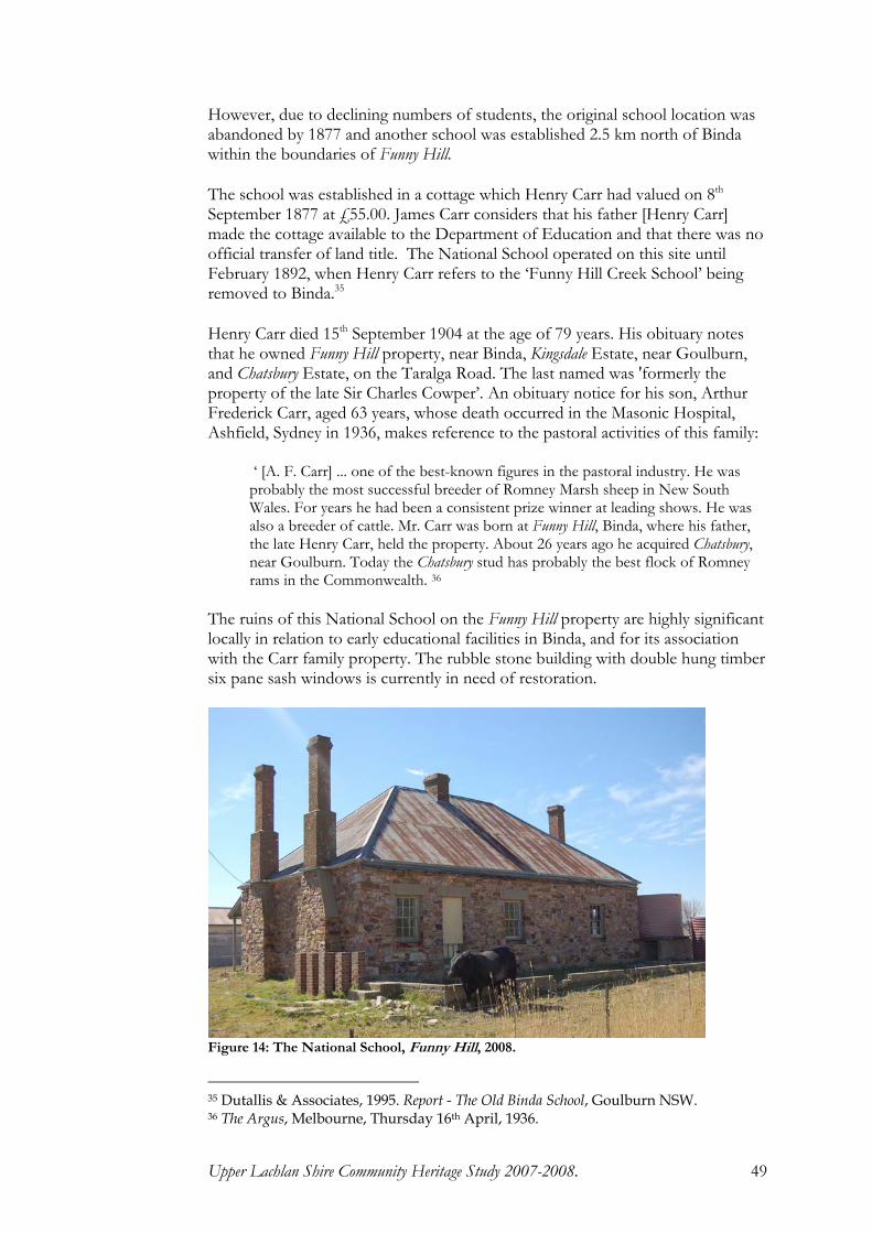
Upper Lachlan Shire Community Heritage Study 2007-2008. 49
However, due to declining numbers of students, the original school location was abandoned by 1877 and another school was established 2.5 km north of Binda within the boundaries of Funny Hill.
The school was established in a cottage which Henry Carr had valued on 8th September 1877 at £55.00. James Carr considers that his father [Henry Carr] made the cottage available to the Department of Education and that there was no official transfer of land title. The National School operated on this site until February 1892, when Henry Carr refers to the ‘Funny Hill Creek School’ being removed to Binda.35
Henry Carr died 15th September 1904 at the age of 79 years. His obituary notes that he owned Funny Hill property, near Binda, Kingsdale Estate, near Goulburn, and Chatsbury Estate, on the Taralga Road. The last named was 'formerly the property of the late Sir Charles Cowper’. An obituary notice for his son, Arthur Frederick Carr, aged 63 years, whose death occurred in the Masonic Hospital, Ashfield, Sydney in 1936, makes reference to the pastoral activities of this family:
‘ [A. F. Carr] ... one of the best-known figures in the pastoral industry. He was probably the most successful breeder of Romney Marsh sheep in New South Wales. For years he had been a consistent prize winner at leading shows. He was also a breeder of cattle. Mr. Carr was born at Funny Hill, Binda, where his father, the late Henry Carr, held the property. About 26 years ago he acquired Chatsbury, near Goulburn. Today the Chatsbury stud has probably the best flock of Romney rams in the Commonwealth. 36
The ruins of this National School on the Funny Hill property are highly significant locally in relation to early educational facilities in Binda, and for its association with the Carr family property. The rubble stone building with double hung timber six pane sash windows is currently in need of restoration.
Figure 14: The National School, Funny Hill, 2008.
35 Dutallis & Associates, 1995. Report - The Old Binda School, Goulburn NSW. 36 The Argus, Melbourne, Thursday 16th April, 1936.

Upper Lachlan Shire Community Heritage Study 2007-2008. 50
The Flag Hotel was used by Ben Hall during his raid on Binda on 26th December 1864. Hall, John Gilbert and John Dunn robbed the store of Edward Morriss, a former police officer, then rounded up the residents and locked them in the Flag Hotel where the gang proceeded to enjoy the Boxing Day ball. Morriss escaped and alerted police however, Hall, angered by Morriss’ actions, burnt down his store. The discovery of gold at Tuena in the 1850s was highly important to Binda’s development as the village was on the route to the goldfields. However, by 1864 the town of Crookwell to the south had slowed further growth in Binda. The 1909 a census showed approximately 300 residents, with most living on farms surrounding the village. Only minimal construction took place from the 1870s. Binda remained a rural village where the fabric of its social life revolved around the properties, local commercial stores, its schools and churches. Sport, particularly tennis, was of great interest to residents. Four tennis courts were built on the 'Flat' and the tennis club had over 200 members. Additional courts were constructed behind the Anglican rectory in 1929. A cricket club was founded in 1880, and rugby and hockey teams were established in 1922 and 1932 respectively. During the 1920s Binda shared in the general post-war prosperity of rural Australia. A Memorial Hall was erected in 1920 and the Graziers Association was established in 1923. The Sisters of Mercy established a convent and school in 1920 and this continued to operate until 1958. Many of Binda's historical buildings have undergone minimal changes to their external fabric and residents have undertaken excellent restoration on many of 19th century buildings. THE BINDA MILL The Binda Mill, a large stone building was erected in Queen Street, as a steam mill c.1890. Prior to completion the owner, George King was killed when he fell from scaffolding. The building stood unused on Binda Flat until World War II. The machinery, which had never been installed, was requisitioned for the war effort. The building is now a private residence. The adjoining building, the miller's residence was also erected c.1890.

Upper Lachlan Shire Community Heritage Study 2007-2008. 51
Figure 15: The Binda Mill
ST. JAMES’ ANGLICAN CHURCH, BINDA, C.1864. St James’ Anglican Church, a Gothic Revival bluestone and quartzite structure with dressed sandstone sills and fine stained-glass windows was consecrated in 1864 with Rev. R. Leigh as minister. St. James’ has served as the centre for the Anglican Parish of Binda to the present time. It is socially and culturally important for its association with the spread of the Church of England in rural New South Wales. In 1874 the Anglican Rectory was constructed for Rev. James C. Betts. Known as The Parsonage, this building was designed by Rev. Alberto Dias Soares. Renowned as an architect, Soares drew up plans for churches, parsonages, schoolhouses and halls.37 New additions to the rectory were undertaken in 1928 to the design of Sir Charles Rosenthal. Dances and social gatherings were also held in the Parish Hall.38
37 Matheson, I., 1976. 'Soares, Alberto Dias (1830 - 1909)', Australian Dictionary of
Biography, Volume 6, Melbourne University Press, p.163. 38 St. James, Binda, Anglican Diocese of Canberra and Goulburn.

Upper Lachlan Shire Community Heritage Study 2007-2008. 52
Figure 16: St. James’ Anglican Church, Binda.
BINDA CEMETERY Binda Cemetery has graves from dating from the 1840s, including members of many pioneering families.
Figure 17: Binda Cemetery, NSW.

Upper Lachlan Shire Community Heritage Study 2007-2008. 53
OLD SALISBURY PRIVATE CEMETERY The old Salisbury Private Cemetery is located on the property, Glengarry, off Salisbury Road, in the Parish of Keverstone. The Cemetery was first used in December 1865, when John and Mary Hearne’s eight year old daughter, Charlotte Bright, died of fever on Christmas Eve. Over the course of the next 60 years, a further 23 members of the Hearne family were buried at Salisbury, including John and Mary Hearne.39 The Salisbury Private Cemetery has local heritage significance for its research potential to understand the living conditions, circumstances, values and genealogy of a pioneer family.
Figure 18: Salisbury Cemetery [Photographs courtesy of Maisie-Sue Mitchell]
39 Information courtesy Maisie-Sue Mitchell, Goulburn.

Upper Lachlan Shire Community Heritage Study 2007-2008. 54
ROSE COTTAGE, BINDA. Adjacent to the original Flag Hotel building is Rose Cottage, built as an inn c.1890.40 This is now a private residence with rooms of substantial proportions featuring pressed metal ceilings and original timber mantle pieces. This building reflects the history of Binda and is highly significant locally. It makes a distinct contribution to the Queen Street streetscape.
Figure 19: Rose Cottage, Binda.
FORMER POST OFFICE AND STORE, BINDA. A Post Office was established at Binda in 1852 and the original post office became the Flag Hotel. By 1859 there were two mail runs per week between Tuena, Binda and Goulburn, with the mail carried on horseback. This building was erected for the McDonald family c.1870 and subsequently used as a post office and store by various owners. The post office was operated from the room on the right of the verandah and a ladies dress store occupied the large front room. The building, now a private residence, is highly significant locally for its heritage qualities and intact fabric. It is a feature of Binda’s main thoroughfare.
40 Cummins, W.P., 1998. The Village of Binda: A History, W. Cummins, Binda.

Upper Lachlan Shire Community Heritage Study 2007-2008. 55
Figure 20: Former post office and store c. 1870, Binda.
Figure 21: Binda Post Office operated from this building c. 1951.41
41 National Archives of Australia, Image: C4077 Binda.

Upper Lachlan Shire Community Heritage Study 2007-2008. 56
MARKDALE HOMESTEAD Markdale Homestead and garden combine the talents of two Australian icons; Edna Walling, garden designer, and the noted architect, Leslie Wilkinson. Markdale is a working sheep and cattle farm of more than 3,000 hectares and has been in the Ashton family for nearly a century. The homestead was built c.1920. In 1951 Wilkinson, the first professor of architecture at Sydney University, redesigned the house around the garden. Apart from enclosing verandahs and building a second storey, Wilkinson added some trademark touches such as the dovecote and cupola on the roof. He also put in a number of large windows and timber shutters. In the 1980s the homestead had an interior makeover using traditional country styling. The garden at Markdale was first planted in 1920. It was re-designed in 1949 by Edna Walling, considered to be the pioneer of Australian landscape gardening. Notable features include the dry rock walls made from local granite, the winding paths and twenty one garden beds. Walling was also responsible for including a lake in the design, believing that ‘every country garden should have a gleam of water to give it the qualities of tranquillity and coolness’.42 Walling's style changed very little throughout her career however each garden is unique. She is renowned for her use of stone, especially in low fences or walls and steps, where moss was encouraged to grow. Dense greenery with few flowers, and a naturalness that creates unity between the house and the garden was her hallmark.
Figure 22: Markdale Homestead, near Binda.
42 Watts, P., 2002. 'Walling, Edna Margaret (1895-1973)', in Ritchie, J., and Langmore,
D., (eds.), Australian Dictionary of Biography, Vol. 16, Melbourne University Press, Carlton, Victoria, pp. 474-475.

Upper Lachlan Shire Community Heritage Study 2007-2008. 57
ST. ANDREW'S ANGLICAN CHURCH St. Andrew's Anglican Church, Markdale, consecrated in 1937, is of high local heritage significance for its association with the provision of religious services in country towns. This simple weatherboard construction is representative of the style of building utilised by the Church of England in rural country areas in the early 20th century.
Figure 23: St Andrew’s Anglican Church, Markdale.
KANGALOOLAH CREEK BRIDGE Kangaloolah Creek Bridge is situated on Junction Point Road, which forms part of a connecting route between Bathurst and Goulburn through Crookwell, and the small towns of Binda and Tuena. The favoured Bathurst-Goulburn route in the very early days of settlement was probably a direct route, through Burraga, and no longer in use.43 The route on which the Kangaloolah Creek bridge is located, through Tuena, Binda and Crookwell, probably developed as a track early in the 19th century as settlers moved to the Crookwell and Goulburn areas. An 1858 Post Office Department map shows a road connecting Bathurst with Goulburn through Rockley, Tuena and Binda, although the route may have differed in many details from today's road.44 The road was also serviceable for horse and dray, with produce and supplies carried between the settlements and regional markets. Settlers transported wheat to the mills at Crookwell, Binda and Laggan, and the flour, pollard and bran home again for their own and their animal's food.45 The Tuena Goldrush generated an influx of traffic between Goulburn and Tuena, and the road through Binda was one of the two main routes used. 46Into the 20th century, this route may have shared its prominence with the Bathurst-Goulburn 43 Bayley, 1975, p. 18 44 DMR, 1976, p. 37 45 Bayley, 1975, p. 56 46 Bayley, 1975, pp. 58-9.

Upper Lachlan Shire Community Heritage Study 2007-2008. 58
road through Oberon and Taralga. Both routes were declared Main Roads under the 1906 Local Government Extension Act, and again under the 1924-27 Main Roads Act.47 The road through Binda and Tuena is now known as Junction Point Road after one of the 1870-1880s gold diggings. The three span reinforced concrete beam bridge over Kangaloolah Creek was constructed by W. McKay of Young, between April 1940 and June 1941, under contract to the Department of Main Roads (DMR). It replaced a timber bridge constructed by the Department of Public Works in 1893. By 1933 this timber bridge was in poor condition, and the DMR began planning for a new concrete bridge over the creek.48 The new concrete bridge was built slightly upstream from the old crossing. During the period 1925-1940 the DMR adapted existing standards of bridge design to meet the requirements of improved motor vehicle performance. They were generally wider than previously with an improved load capacity. The principal types of bridges constructed during the period were: reinforced concrete beam; concrete slab; steel truss on concrete piers; and timber beam bridges. Concrete was favoured in many instances because it was perceived to be a low maintenance material.49 Based on RTA bridge database records, reinforced concrete beam or girder bridges were the most common form of concrete bridge construction to 1948. They have been very popular in NSW, providing an efficient and often aesthetically pleasing solution to a wide range of crossing types. Within the general group of beam bridges, the main longitudinal members have had various configurations ranging from a simple set of rectangular beams cast integrally with the deck, through to beams with curved soffits, to flat soffit decks where the edge beams also form the bridge parapet or sidewall. These bridges on the State's main roads and highways were constructed to replace high-maintenance and aged timber bridges or open crossings. Along with other road improvements, they ushered in the age of comfortable motor transport and efficient road transport of goods and produce. The fencing and embankments on the approaches to the Kangaloolah Creek bridge were designed with regard to the large numbers of stock travelling on the road. It was reported to the DMR's Divisional Engineer that at least one large mob used the crossing every day and that after sale days, stock traffic was very heavy.50 The construction of the bridge approaches to accommodate travelling stock indicates that the structure would be well patronised by local producers in the course of their farming activities. At the request of residents of the Binda district an official opening of the bridge was held on Saturday 26th April 1941. The ceremony was performed by Mr Ardill, the Member for the District. Mr L. Irvine, the Divisional Engineer, and Mr Langford were also present.51
47 DMR, 1976, p. 37, maps opp. pp. 64, 112. 48 RTA File 106.153 and 106.134. 49 DMR, 1976, pp.169, 170. 50 RTA File 106.153; 1. 51 RTA File 106.153;1

Upper Lachlan Shire Community Heritage Study 2007-2008. 59
BREADALBANE The village of Breadalbane is located on the Old Hume Highway together with Cullerin and Gunning. An early Government Notice published in the Sydney Gazette and New South Wales Advertiser describes the potential for pastoral settlement in the area.
GOVERNMENT NOTICE. Secretary's Office, Sydney, 9th December, 1820. HIS Excellency the Governor, having Reason to believe that granting Permission to the Proprietors, of Herds and Flocks to depasture the New Country, situated between Bargo Brush and Cookbundoon Range, as already done in the Government Notice of the 25th Ultimo, would be of material Benefit to those Persons by relieving their Lands in the County of, Cumberland, now in an exhausted State, and being now informed that the Benefit would be still much increased by dispensing with the Limitation as to the Range of Pasturage where it is confined to the said Cookbundoon Range; His Excellency is pleased to notify, that this Limitation is accordingly done away, and that all the open Country called Breadalbane and Goulburn Plains to the Southward and Westward of said Range, not otherwise appropriated, may be in like Manner depastured as the Country laying between Bargo and Cookbundoon Range, according to the former Notification; subject however to the third Regulation in that Notice. His Excellency is pleased to notify further, that when it shall be found necessary to locate specially the Lands laying between Bargo Brush and Cookbundoon Range, those Persons who may have Herds or Flocks, at that Time on those Lands, will have Permission to send them over Cookbundoon Range to Breadalbane and Goulburn Plains, and thence to proceed with them at their own Discretion, not interfering with Lands already appropriated to any special Purposes, By His Excellency's Command, J. T. Campbell, Secretary.
The Plan of 99 portions of land at the Third Bredalbane Plain, Mutmutbilly, Dairy Flats completed in 1856 by the Surveyor-General’s Office, NSW, provides an excellent reference to the historical landholders. Note that on this plan, the historical spelling of the name ‘Bredalbane’ is used.

Upper Lachlan Shire Community Heritage Study 2007-2008. 60
Figure 24: Bennett, E. J. Plan of 99 portions of land at the Third Bredalbane Plain, Mutmutbilly, Dairy Flats etc. County of Argyle. 1856.52
INNS AT BREADALBANE Several properties at Breadalbane identified as having heritage significance were formerly hotels / inns. These were established from the early part of the 19th century through to the early 20th century. There is some confusion regarding the naming and licensees of these inns. The properties are now known as Rosythe, Sweetwood Lea, and the former Hotel Breadalbane. A public house was advertised under the name of Thatched Cottage, ‘Breadalbane Plains’. Although this in was held for a period by John Reid, it is not considered to be one of the three premises noted above.53
52 National Library of Australia, Ferguson Collection, MAP F 794. 53 Sydney Morning Herald 13th September 1844

Upper Lachlan Shire Community Heritage Study 2007-2008. 61
ROSYTHE One of the earliest extant buildings in Breadalbane is Rosythe, a two-storey Georgian style rendered stone residence which makes a valued contribution to the historical village landscape. Gilbert and Wilson in Rural Inns of the Goulburn District, 1830-1900, refer to the building, as dating to 1838 when it was established as the ‘Brisbane Arms’. Perhaps this was meant to be the Breadalbane Arms , as noted in the following press article. On Friday 6th July, 1838 a notice published in the Sydney Herald was as follows:
We understand that a Mr. John Reid has opened a large and commodious Inn at Breadalbane Plains, Argyle, under the name of the "Breadalbane Arms." We are of opinion that it is by the licensing of respectable Inns, in suitable stations throughout the Colony that the evils of the sly-grog system can be put down.
Reid obviously continued to hold the licence for some years. However reference is made not to the ‘Breadalbane Arms’ but to the Breadalbane Inn in the Yass Mail and copied to the Sydney Gazette and New South Wales Advertiser, Thursday, 24th October 1839:
It will be recollected that a short time since the Yass mail was robbed; the robbery created a good deal of discussion, and the police, horse and foot, were condemned for not putting down the bushrangers. Recent accounts mention that the mail has been again robbed, at a short distance from the Breadalbane Inn, and by a single robber. In what state must the Yass Post-office department be, and to what sort of men are the mails entrusted, when they will suffer themselves to be robbed by a single man without making any resistance. The frequency of these outrages calls loudly for amendment in this department. The account of the latter robbery is thus given by a correspondent of The Monitor: This very afternoon the Yass Mail was stopped by a single man about two miles the other side of the Breadalbane Inn (Reid's)...
John Reid appears to have left the Breadalbane Inn prior to September 1843 at which time during a court case at Berrima, he is referred to as a ‘farmer at Breadalbane’. By 28th November 1848 the lack of suitable accommodation on the Breadalbane Plains is obvious as reported in the notices of Publican’s Licences issued from the Courthouse at Goulburn. Joseph Fletcher, referred to as ‘Joseph Fletcher, Red House, Breadalbane Plains’, was issued with a licence with the added comment ‘...where a house is very much wanted’.

Upper Lachlan Shire Community Heritage Study 2007-2008. 62
Figure 25: Notice in the Sydney Morning Herald, Tuesday 5th December 1848, p.3.
Further reference to the Breadalbane Inn is made in the Goulburn Herald, 3rd February 1849, where the licensee is noted as ‘Mr. J. Fletcher’. The premises were ransacked by three armed men and Fletcher, his wife and a lodger were robbed. Fletcher again applied for the renewal of his licence at the Goulburn Court in 1850 and ‘Fletcher’s public house ... on the Breadalbane Plain’ was noted in the report of a bushranging incident in the Sydney Morning Herald, 4th April 1851.54 On Wednesday, 8th June 1853, William Russel Riley placed an advertisement in the Sydney Morning Herald, advising that he has taken over the premises of Joseph Fletcher and that the inn will be operating under the sign of The Coach and Horses Inn as from 1st July.
Figure 26: Advertisement for William Riley’s Coach and Horses Inn to be opened 1st July 1853.
Riley was again receiving press comment in October 1853 for
54 Sydney Morning Herald 13th April 1850.

Upper Lachlan Shire Community Heritage Study 2007-2008. 63
apprehending a horse-keeper, Henry Ryan, alias ‘Long Harry’, who was responsible for the mail coach horses of Mr. Elliott at the Coach and Horses Inn staging post. Ryan was charged with selling produce belonging to both Riley and Elliott.55 Only one week later, and barely three months after opening the inn, Riley advertised his Breadalbane premises and adjoining land for lease. The importance of this advertisement is the statement: ‘there being no other public house within fifteen miles’.
Figure 27: Coach and Horses Inn available for lease advertised in the Sydney Morning Herald, 24th October 1853.
Under the name of the Coach and Horses Inn, the building was leased to Thomas J. Lodge prior to 14th February 1854. On that date an advertisement in the Sydney Morning Herald concerning a reward for a lost horse, refers to Lodge’s occupancy of the inn. Lodge continued to hold the license for the Coach and Horses from 1856 to 1858 at which time he relocated to the property now known as Sweetwood Lea. There he established another inn under the name ‘Breadalbane Inn’. The new licensee of the Coach and Horses was Webb Garrett who changed the name to the Red House Inn. Garrett remained at the Red House until 1865 until it passed to John Hilton who held it until his death in 1869. Henry Slater then acquired the lease and the inn was frequently advertised for lease. In 1873 George Withers secured a licence, however this was held for only a short time. The building is now a private residence.
55 Sydney Morning Herald 19th October 1853.

Upper Lachlan Shire Community Heritage Study 2007-2008. 64
Figure 28: Rosythe, established as an inn c.1838 as the ‘Brisbane Arms’ or ‘Breadalbane Arms’ .

Upper Lachlan Shire Community Heritage Study 2007-2008. 65
SWEETWOOD LEA This property is located on the Old South Road to the north-west of Breadalbane with expansive pastoral views across the Breadalbane Plain towards the Cullerin Range. The name ‘Sweetwood Lea’ is said to have been given to the property c.1920 by John Hannan.56 It is probable that the building was constructed in the late 1820s and may have been one and the same as Archer’s Inn which operated as a Cobb and Co changing station c.1832. It is stated that the earliest reference to the property was in December 1837 when tenders were granted for the conveyance of the mails between Goulburn, Lake George, and Mutmutbilly [described as ‘a small settlement on the Breadalbane Plain, half way between Gunning and Goulburn’.57 The following information concerning the property Sweetwood Lea was provided by Shlomi Bonet, from research by Roger Bayley. Bayley states that Thomas J. Lodge, an Englishman previously held the license for the Coach & Horses Inn. Lodge then reputedly changed the name to the Breadalbane Inn and traded under that name from 1853 – 1858. When Lodge moved to the site of Sweetwood Lea, he retained the name Breadalbane Inn. In 1860 it became the Post Office for the area known as Mutmutbilly and was the changing station for Cobb & Co. The inn was the centre of a prosperous village until the onset of the railway line and the realignment of the main road. The commercial hub of the village then became established to the east. Heavily laden coaches on the Breadalbane Plains were often slowed by wet weather and rough tracks making them a target for robberies. Wagons laden with supplies including alcohol for the district’s inns, were also subject to bushranging activities. After the Breadalbane Inn was held up in 1863, Thomas Lodge became a supporter and confidant for bushrangers including Frank Gardiner, Ben Hall and the Clarke Brothers. In return for his information, Lodge received his ‘take’ from the robberies. Lodge was known to police and appeared in Goulburn Court on several occasions charged with harbouring bushrangers and receiving stolen goods. The animosity of the police towards him is evident by some of the trivial charges that were levelled against him including ‘Permitting drunkenness in his hotel’ for which he was fined £5 plus costs, and also for ‘Allowing music and dancing’. In January 1865, following the shooting of Constable Nelson at Collector, Ben Hall and his associates sought shelter at the Breadalbane Inn, only to find that Thomas Lodge was in custody in Goulburn. Although the inn was raided by police shortly after the incident, Hall had fled. Police then arrested twenty eight known sympathisers. Police supposedly frightened the wife of Thomas Lodge to the extent that he wrote a letter complaining against police brutality.58
56 Shlomi Bonet – Pers. comm.. 2008. 57 Weatherstone, G., 1986. Parkesbourne, A Journey into the Past, G. Weatherstone,
Gunning, NSW. 58 Bayley, R. 2009. Sweetwoodlea.

Upper Lachlan Shire Community Heritage Study 2007-2008. 66
Figure 29: Sweetwood Lea 2008.
It is known that the building was held by the Hannan family c.1870. John Hannan and Ellen Kelleher were married at Liverpool, NSW in 1852. John had been born in County Leitrim, Ireland about 1820 and Ellen had been born in County Clare in 1833. They had been living at Mutmutbilly since 1855. Ten children were born to this couple between 1855 and 1875.
Figure 30: Renewal of Publican’s Licence No. 2046, issued to John Hannan for the Breadalbane Hotel on 30th June 1876.59
59 Document courtesy Shlomi Bonet, Breadalbane, NSW.

Upper Lachlan Shire Community Heritage Study 2007-2008. 67
HOTEL BREADALBANE
Figure 31: Hotel Breadalbane, 2008, now a private residence.
The village of Breadalbane, named by James Chisholm, developed with the completion of the railway from Sydney. The railway station, opened by Chisholm on 9th November 1875, remained in service for almost a century. Economic prosperity brought with it the need for services. The Hotel Breadalbane was licensed in 1878 to Thomas Apps. Then followed a succession of tenant-licensees: Francis Poidevin 1880-1885; Bernard Cullen 1885-1886; Richard Cullen 1886; James Sykes 1887. The licence then reverted to Thomas Apps. Stewart McInerney held the licence briefly in 1889 before Apps again resumed as proprietor.60 Rebuilding of the hotel was undertaken in 1913 by W. C. Apps, and a gabled naming plate was added. The building is representative of the design for country inns during the late 19th and early 20th century and has retained much of its heritage value.
60 Wilson, L.W., and Gilbert, W.S., 1989. Rural Inns of the Goulburn District (1830-1900),
W.S. Gilbert, Goulburn.

Upper Lachlan Shire Community Heritage Study 2007-2008. 68
BREADALBANE PUBLIC SCHOOL Formal education in Breadalbane was provided prior to 1866 by a Catholic School which in 1867 became a certified denominational school. In 1868, it became a provisional school, although soon experienced difficulties because of insufficient pupils attending and eventually closed. After pressure from local residents and the opening of the railway boosted potential student numbers, the Breadalbane schoolhouse, a slab and bark building was built by local residents on land donated by James Chisholm and was opened in 1875 as the ‘Muttbilly’ Provisional School. This became the official Breadalbane Public School in 1876.
Figure 32: Sign ‘Public School 1876’ on the Old Breadalbane School, Old South Road. [Photo courtesy Shlomi Bonet]. John Hannan was the first of a list of parents who, in 1885, requested the ‘Department of Instruction’ to provide more adequate accommodation for the teacher and his family of nine. By 1885 there were 64 children attending
the school. The school building is now a private residence. By 1927 it was decided a more central site was required for the school and the Department of Education purchased two acres from W. A. Bodel. In 1931 the school moved to the present site. It is probable that one of the present buildings was relocated from the old site.61 Throughout its history the school has played a vital role in the community.
Figure 33: Breadalbane Public School.
61 NSW Department of Education and Training communication to Upper Lachlan
Shire Council, 13th August 2009.

Upper Lachlan Shire Community Heritage Study 2007-2008. 69
ST. BRIGID’S CATHOLIC CHURCH St Brigid’s Catholic Church was erected in 1874 at the junction of Mutmutbilly Road and the old Hume Highway, approximately 9km northwest of Breadalbane.. This peaceful area is surrounded by pine trees. There is a cemetery at the rear of the church. Headstones in the cemetery were transcribed on 19th February 1983 by Gwen and Stuart Anderson. St Brigid's Church was constructed for Rev. Fr. Michael McAlroy who had been posted from Albury to Breadalbane.62 The land on which the church was built was owned by John Hannan. In 1872 several of families used ‘Mutt Billy’ as their address, including John Hannan, whose occupation was given as storekeeper. From 1868 to 1875 he is shown as publican of the Breadalbane Hotel.63
Figure 34: St Brigid’s Catholic Church, Breadalbane, NSW. [Photo courtesy Michael Coley, Caxton House, Gunning, NSW] The cemetery at St. Brigid’s Catholic Church, Mutmutbilly [Breadalbane] has also been recorded by Graeme Challinor.64 The broken headstone of James Thomas McCabe [No.37] was recovered from the property Sweetwoodlea and has been restored to the gravesite. Details of the burials include: 1 Bridget Corcoran died 23.9.1885 aged 74;2 Elizabeth Wright died at Goulburn 17.1.1908 aged 75;3 William A Bodle died 25.12.1963 aged 78;4 Henry Robert Bodel died 12.7.1962 aged 82;5 Blanche Josephine Bodel died 10.8.1931 aged 40;6 David Bodel died 9.1.1951 aged 73;7 Sarah Jane Bodel died 1.7.1937 aged 61;8 Hannah Bodle died 20.9.1926 aged 75;9 Margaret Clarke died 23.12.1898 aged 40;10 John Drew died 25.1.1896 aged 18, and Ellen Drew, mother of the above, died 3.2.1876
aged 64; 11 John Duggan died 12.5.1878 aged 66, and Catherine Duggan, wife of the above, died
2.12.1885 aged 72; 12 Winifred May Foley died 27.7.1909 aged 14 yrs 11 mon,and Leo Patrick Foley died
7.8.1909 aged 2, both children of Edward Joseph Foley and Catherine Foley;
62 Greville’s Directory, 1872. 63 Information on John Hannan courtesy Myles Hannan, Weetangera ACT. 64 http://www.gundaroo.info/genealogy/index.htm;

Upper Lachlan Shire Community Heritage Study 2007-2008. 70
13 [no headstone] 14 Michael Delaney died 16.1.1964 aged 8015 John Thomas Bodel died 9.2.1959 aged 7616 Ellen Mary Bodel died 6.4.1928 aged 3417 Francis O'Keefe died at Gurunda 29.8.1881 aged 48; native of Co. Cork, Ireland
[monument erected by his brother Timothy] 18 Martin Quinn died 11.2.1884 aged 74
native of Co. Galway, Ireland 19 Patrick Joseph Quinn died 17.4.1885 aged 2320 Celia Margaret Quinn died 25.12.1898 aged 7721 [iron railings around 21 and 22]; Rose Goodwin died 28.7.1885 aged 69, and Matthew
Goodwin, husband of the above, died 15.9.1893 aged 80; 22 Mary Agnes Clancy died at Goulburn 26.6.1889 aged 2723
Thomas Goodwin died 20.3.1898 aged 57, and Mary Jane McCabe died 19.3.1907 aged 26, and James Goodwin died 31.3.1898 aged 47;
24 Esther Teresa Sullivan died 3.10.1915 aged 64, and Thomas Sullivan, husband of the above, died 31.7.1925; aged 77, and Thomas John Sullivan died 31.8.1922 aged 44 son of the above.
25
Ellen Filand died 27.6.1917 aged 72, and Patrick Filand died 31.12.1933 aged 81;
26 Catherine Mary Sullivan died 25.9.1911 aged 34, and Michael Joseph Sullivan, husband of the above, died 24.2.1934 aged 59;
27 Martin Leo Sullivan died 16.12.1955 aged 68, and Patrick James Sullivan died 4.12.1936 aged 54;
28 Frank Goodwin died 13.6.1927 aged 67, and Bridget Goodwin, wife of the above, died 21.2.1926 aged 61;
29 Elizabeth Humphries, wife of Frank Humphries, died 1.12.1899 aged 18; 30 Mary Alice Woods died 15.3.1874 aged 8 months 4 days;31 George Withers died 29.8.1878 aged 88;32 Susannah Withers, wife of George, died 25.2.1880 aged 78;33 Mary Ann Conningham died 1882 aged 84, native of Co. Lathrain [?], Ireland 34 Mary Ann Byrne died 4.8.1874 aged 27;35 Thomas Byrne died 9.2.1888 aged 69, native of Dublin, Ireland; 36 Mary Measey Nichols born 12.3.1874 died 19.11.187637 [headstone broken] James Thomas McCabe, born June 11 1869 died at Mummell
10.6.1889 [headstone states 1890] footstone] J Mc C 38 Mary O'Keeffe died at Gurrundah 3.1.1888 aged 76, native of Co. Cork, Ireland 39 Ellen Hallahan died at Gurrundah 10.3.1874 aged 60; also Patrick Hallahan died 10.3.1884
aged 79 40 John Peter Hallahan died 17.6.1879 aged 42; also Daniel Hallahan died 21.12.1870 aged 1541 Timothy William Cotter died 8.8.1913 aged 47;42 Michael John Atkinson accidentally killed 17.11.1965 aged 15;43 Peter Edward Hannan of Cullerin born 29.3.1931 died 16.12.1989, and Marjorie Lillian
Hannan, his daughter, born and died 20.9.1962. 44
Gerald Edward Hannan died 7.8.1976 aged 76, and Winifred Theresa Hannan died 27.6.1978 aged 92;
45 Myles Patrick Hannan died 21.2.1971 aged 76;46 Leslie Joseph Hannan died 11.1.1960 aged 75;;47 Theresa Hannan, wife of Frank Hannan, of Cullerin died 29.10.1919 aged 58, and her son,
Francis E Hannan died 18.4.1893 aged 3, and Francis J Hannan died 30.1.1940 aged 82; 48 John Hannan died 2.3.1891 aged 70, and William Hannan died 4.2.1876 aged 5, and Ellen,
wife of John Hannan, died 12.1.1915 aged 81, and Myles B Hannan, son of John Hannan, died 8.1.1917 aged 50, and Edward [Joseph] Hannan, son of John Hannan, died 13.9.1909 aged 32 [aged 33 from birth and death data]; A separate headstone for Edward [Joseph] Hannan has now [2007] been erected between 48 and 49.
49 Dennis Joseph Heffernan of Gurrundah, son of William and Mary Heffernan, died 27.12.1906 aged 21 years 7 months;

Upper Lachlan Shire Community Heritage Study 2007-2008. 71
50 Margaret Mary Heffernan, daughter of William Heffernan, died 17.6.1901 aged 22; 51 Margaret Mary Heffernan, wife of William Heffernan, died 8.6.1878 aged 27; 52 Hannorah Heffernan died 7.6.1923 aged 53, and Ellen Heffernan died 26.5.1927 aged 47;53 Ann Heffernan, wife of Patrick Heffernan, died 8.12.1882 aged 38; 54 John Sullivan died 28.3.1915 aged 71, also his wife, Margaret Sullivan died 12.1.1938 aged
94; 55 [broken iron railings] Mary O'Keefe, wife of John O'Keefe, died 22.1.1884; aged 48, and
Elizabeth O'Keefe aged 1 year 1 month; 56 David Field, son of Jeremiah and Margaret Field, died 8.10.1885 aged 36; 57 Catherine Cahill, wife of William Cahill, died 19.11.1900 aged 52; 58
John Mahon died 23.11.1891 aged 82, and his wife, Mary Mahon died 1.4.1858 aged 43monument erected by their daughter Julia Mahon;
59 Leo Hannan died 15.4.1951 aged 47;60 John J Hannan died 12.1.1938 aged 80;61 Karl Joseph Hannan died 26.7.1959 aged 57;62 John Bartholomew Hannan died 26.8.1975 aged 63;63 Cecily Clare Hannan died 4.11.1985 aged 78;64 Pauline Elizabeth Hannan died 5.12.1986 aged 76;65 Philippa Marea Hannan died 2.2.1946 aged 1 year 9 months;66 Father Gregory Thomas Hannan accidentally killed19.9.1975 aged 37; 67 Myles Francis Hannan died 11.10.1979 aged 75;a Catherine O'Neill (née Foley) died 2.3.1897 at Gullen, buried 4.3.1897, aged 68. Daughter
of Daniel Foley and Mary Reardon. Native of County Cork, Ireland, and her husband; b Owen O'Neill died 6.3.1922 at Kingsdale, buried 8.3.1922 aged 102. Native of County
Cork, Ireland. c Margaret Neville (née Kelleher) died 16 December 1812 at Goulburn Hospital aged 73.
Native of County Clare, Ireland, wife of Patrick Neville. d Mary Jane Neville died 8 April 1897 at Goulburn Hospital aged 20. Daughter of Patrick
and Margaret Neville. e Denis Foley died 2 Sep 1892 at Gurrundah, buried 4 Sep 1892, aged 65. Son of Daniel
Foley and Mary Reardon. Native of County Cork, Ireland. RAEBURN HOMESTEAD AND STABLES Access to this property was unavailable during the course of the study. The Mitchell Library, State Library of New South Wales, holds a collection of material including Scenes of Raeburn, Breadalbane, and the Chisholm family, ca. 1914-1968. These photographs include a portrait of Mr & Mrs Edward Gerald Chisholm and family in Raeburn grounds, ca. 1914-1918 and at St. Silas' Church, Breadalbane. ‘The Raeburn Story...’ was published in the Canberra Times, 2nd February, 1967.65 CHURCH OF ST SILAS, BREADALBANE The Church of St Silas is important for its community associations in Breadalbane and with the spread of the Church of England’s religious services in rural New South Wales. The elongated and steeply sloping roofline of this building makes it a distinctive feature of the Breadalbane rural landscape. The church is located at the corner of Cullerin and Breadalbane Roads. Marriages in longstanding Breadalbane families have been a feature of St Silas’ history. John Alt was married to Mary Ann Crawford Smith, daughter of Thomas Maxwell Smith and Ann Murray, on Wednesday, 22 April 1891. Lindsay Robert Poidevin married Edna Lillian Morton, daughter of William John Morton and Elizabeth Ada Matthews, on 9th July 1942. 65 SLNSW ML MSS 1621 Mitchell Library.

Upper Lachlan Shire Community Heritage Study 2007-2008. 72
Figure 35: John Alt, Breadalbane 1891.
Figure 36: Church of St Silas, Breadalbane.

Upper Lachlan Shire Community Heritage Study 2007-2008. 73
COLLECTOR The village of Collector is located within the Parish of Collector, County of Argyle. In 1820 from the hillside central to the Collector village, Governor Lachlan Macquarie and Reverend Robert Cartwright, marvelled at the great expanse of water to the south. Cartwright emigrated from England to New South Wales in 1810 to take a colonial chaplaincy. Cartwright was appointed to Liverpool in 1819 and remained there seventeen years, until he was made incumbent of St. James's, Sydney on the death of Reverend Richard Hill in 1836. He was also master of the Male Orphan School (1825-1829). From around 1838, Cartwright erected a church, school and house to the west of the Collector Store, c.1838 and worked throughout the southern districts until his death at Goulburn in 1856. Collector was first settled when Terrence Murray was granted land in 1829. He built a home behind the Collector Inn, down toward the creek. Murray eventually settled on the property Winderadeen in 1837 becoming generally known as the ‘Father of Collector’. Murray commissioned a surveyor to layout the village of ‘Murray town’ or ‘Old Collector’ in 1841. Streets were named after his friends, Bourke after the governor who appointed him magistrate and O'Sullivan the agent of the Goulburn Commercial Bank. Murray was responsible for the introduction of Murray Cod into local waterways. These he transported in barrels from the Molonglo River near Yarralumla. By 1837 a postal service was established from Goulburn across the flat plains to Lake George and down to Yass. The need for coaching stations led to the development of both Gundaroo and Collector. By 1847 Collector had an inn, store, three hotels, several blacksmiths’ shops and a tailor. The village was illuminated by oil lamps in 1850 and a wind powered mill was operating in 1859 the year in which ‘new’ Collector was surveyed on higher ground. Twenty six years later, the village was declared a town. Because of its location on the road to the southern goldfields, Collector attracted the attention of numerous bushrangers including Frank Gardiner and Ben Hall. On 26th January 1865 Hall’s gang, including Johnny Gilbert and John Dunn, held up Kimberley’s Commercial Hotel and the adjacent Wellington boot store. Constable Samuel Nelson tried to apprehend them however was shot dead during the fracas. Alluvial gold yields had declined by the 1860s and the only businesses remaining were the General Store and two hotels – the Bushranger and the Wheat Sheaf. Fire destroyed many of the early historical records of Collector which were stored in the School of Arts. The Collector Court House was demolished in 1952 and the materials used in the construction of the Memorial Hall.

Upper Lachlan Shire Community Heritage Study 2007-2008. 74
WHEAT SHEAF INN Patrick Davoran, born in 1828 in County Clare, Ireland, was the inn keeper of the Wheat Sheaf Inn. Davoran arrived in New South Wales on 19th November 1849. He married Bridget Brogan at Collector on 22nd August 1855. Bridget, who was born at Spring Valley became postmistress. Patrick died in Collector on 3rd November 1872.
Figure 37: The original Wheat Sheaf Inn, Collector often mistakenly referred to as Murray's first homestead, c.1829 which was located behind the Collector Inn, down towards the creek.66
BUSHRANGER HOTEL, COLLECTOR. Kimberley's Commercial Hotel c.1860 was one of five inns established in the village of Collector.67 On the 26th January 1865 bushrangers Ben Hall and Johnny Gilbert held up the hotel’s proprietor. Constable Samuel Nelson, Collector’s only police officer, was mortally wounded during his attempt to approach the hotel. John Dunn, had warned Nelson not to advance any further and when Nelson refused, he was shot down. He died in the arms of his son, one of eight children of this family. John Dunn was born on 14th December 1846 near Yass, NSW, the eldest of nine children, to convict parents Michael and Margaret Dunn. In 1864 he joined Ben Hall's gang of bushrangers and embarked on a short but infamous career, raiding stations, inns, stores and mail coaches. Dunn was eventually recaptured and hung at Darlinghurst Gaol on 19th March 1866. He was 19 years of age.68
66 Frank Ross, Collector Gallery & Bookshop, per Keith Marshall. 67 Stevenson, D., 2007. Kimberley's Commercial Inn 1860 ‘History In Focus: Pubs With A
Past’, Photographic Display, Goulburn Mulwaree Council. 68 For an account of John Dunn's recapture see: Penzig, E., 1992. Heroes and Villains,
Tranter Enterprises, Katoomba, NSW; Also `Death of a Teenage Bushranger', The Bulletin, July 1994.

Upper Lachlan Shire Community Heritage Study 2007-2008. 75
The grave of Constable Samuel Nelson is located in the Church of England Cemetery, Collector. There is a monument to Nelson erected on 26th January 1965 by the Wild Colonial Days Society and the Goulburn and District Historical Society. In 1937 the hotel was known as the Hotel Collector. It was subsequently renamed the Bushranger Hotel. There is also a monument to Constable Nelson next to the hotel. It reads 'In memory of a brave officer' and 'This monument is erected by the Government of New South Wales to the memory of Constable Samuel Nelson who was shot dead on this spot whilst in the execution of his duty by the outlaw John Dunn on 26 January 1865'.
Figure 38: The Collector Hotel photographed in 1937.69
Figure 39: The Bushranger Hotel, Collector, 2007.
In April 2009, six places associated with the activities of Ben Hall were nominated for listing on the NSW State Heritage Register. These places include the Bushranger Hotel at Collector as well as Escort Rock, Cliefden, Wandi, Hall’s death site and his grave.
69 State Library of Victoria, Image Number: b51327.

Upper Lachlan Shire Community Heritage Study 2007-2008. 76
The sites are of historical significance in demonstrating the impact of bushranging on 19th century New South Wales. The Ben Hall sites are of State significance due to their associations with the mythology of Ben Hall, the bushranger. The exploits of Hall and his gang were recorded in newspapers of the day and were widely known across New South Wales. The historical treatment of Ben Hall has retained his legend in the public's imagination ensuring he is viewed as a significant person in the history of New South Wales.70 COLLECTOR INN (EST. 1824). The original Collector Inn was established c.1824. Although modified, the building is highly significant locally as a focal point of commercial enterprise in the Collector village.
Figure 40: The site of the original Collector Inn established c.1824, now the Collector Inn General Store.
COLLECTOR PUBLIC SCHOOL Public education in Collector commenced in 1866 as a National School when private premises were used. In 1874 an adjoining stone school and residence was erected on the present school site. Sixty enrolments necessitated a second teacher in 1901. The school was destroyed by fire in 1914 and it was not for another two years that education resumed in the now dismantled Court House. By the end of 1916 the current building was occupied, though structural alterations have been made since that time.71
Figure 41: Collector Public School, Collector, NSW.
70 Letter 24th April 2009 from Cameron White, Heritage Branch, NSW Department of
Planning to General Manager, Upper Lachlan Shire Council. 71 Collector Public School, 2006. Collector Public School 1866-1906: a celebration of public
education, Collector, N.S.W.

Upper Lachlan Shire Community Heritage Study 2007-2008. 77
COLLECTOR MEMORIAL HALL Collector Memorial Hall is significant locally to the residents of the district. It is important socially and culturally and is a focal point for remembrance and recreational activities in Collector. The Hall was built in 1952. Funds to build the hall were raised by loans from residents. The loans were repaid partly by holding dances and horse flag races. The bricks for the foundations were obtained from the demolished Court House.
Figure 42: Collector Memorial Hall.
UNITING [WESLEYAN] CHURCH, COLLECTOR. The Wesleyan Church, later the Uniting Church, was erected in Collector in 1865. The church remains a prominent building in the village landscape and is recognised as being of local heritage significance.
Figure 43: Uniting Church [Wesleyan Church] est. 1865, Collector, NSW.

Upper Lachlan Shire Community Heritage Study 2007-2008. 78
UNITING CHURCH CEMETERY, COLLECTOR. The Uniting Church [Wesleyan] Cemetery is located on Bourke Street.
Figure 44: Grave of Elizabeth Ann Granger, Uniting Church Cemetery, Collector, NSW.
Figure 45: Uniting Church Cemetery, Collector, NSW.

Upper Lachlan Shire Community Heritage Study 2007-2008. 79
Figure 46: Diagram of headstones with inscriptions, Uniting Church Cemetery, Collector. The numbers in the list below refer to locations in the cemetery diagram. [Copyright, Graeme Challinor]. 1 Cyril Geoffrey Bowley born 30.1.1924 died 22.11.1955 aged 312 Albert F. S. Old died 17.1.1973 aged 673 Arthur J. M. Old died 19.7.1973 aged 654 Mona Old died 12.3.1964 aged 54 5 Hubert Old died 12.8.1951 aged 58 6 Herbert Byrnes died 5.7.1932 aged 277 Cynthia R. M. Byrnes died 19.10.1976 aged 79, and baby Byrnes, their son, died 23.8.19318 Amy F. M. Old, wife of Edward Old, died 25.8.1923 aged 519 Edward Old died 8.2.1955 aged 8510 James Granger died 16.6.1925 aged 77; Elizabeth Ann Granger, his wife, died 7.12.1940
aged 79, and Edgar David Granger, killed in France 2.9.1918 aged 26. 11 John Adam Wakartt died 8.10.1945 aged 83, and his sister Galena Jane Wakartt died
3.11.1953 aged 81; 12 Katrine Elizabeth Wakartt died 7.2.1909 aged 82, and John Michael Wakartt died 4.7.1904
aged 84 13 Louisa Jane Schnelle, wife of Louis Schnelle, died 11.3.1901 aged 36 years 7 months.14 Mary Jane Ranger died 15.3.1897 aged 35, and Albert Ranger died 30.7.1938 aged 8115 Sampson Ranger died 12.11.1887 aged 67, and his wife Hannah Ranger died 25.5.1907 aged
80 16 Sampson Ranger, son of Samson Ranger and Hannah Ranger, died 12.1.1877 aged 2117 Amy C. Baxter, died at Collector 29.6.1877 aged 2 years 10 months 18 Capt James Trevarthen, died at Currawang 26.12.1875 aged 5219 Mary Ann Dowling died 2.6.1883 aged 7620 Sam Ranger, son of J.(James) J. Ranger and L. V. (Letitia Violet) Ranger, died at Collector
6.7.1914 aged 17 years 6 month 21 L. V. (Letitia Violet) Ranger died 22.4.1965 aged 91, and her husband J. (James) J. Ranger
died 2.7.1932 aged 65 22 Isabella Cartwright, relict of Rev. R. Cartwright, died 8.8.1883 aged 80 23 Mary Boatfield, relict of James Boatfield, died 3.12.1882 aged 7324 Robert Ruse died 28.8.1921 aged 74, and his wife Sarah Ruse died 25.8.1929 aged 78, and
their son Samuel Boley Ruse killed in action 4.7.1918 aged 36

Upper Lachlan Shire Community Heritage Study 2007-2008. 80
25 Mary Carroll died 11.2.1933 aged 57, and Lizzie Ruse died 15.2.1935 aged 64 26 George Henry Old 1901 - 198027 Ivy Irene Old 1902 - 194028 William Volney Cooper died 1942 aged 7429 Esther Jane Cooper died 27.5.1945 aged 6730 Jack Cooper died 29.12.1962 aged 5631 Edith Emily Wheatley died 27.11.1956 aged 78, and her husband David James Wheatley
died 24.8.1969 aged 86 32 William A. Macauley 1884 - 1939, and Edward H. Macauley 1859 - 1940, and Elizabeth
Macauley 1863 - 1944 33 John Taylor born Greenock, Scotland 1.5.1905 died 3.4.197834 Sarah Granger died 12.9.1917 aged 8835 Joshua Vernal Granger died 29.6.1897 aged 27 - memorial erected by his wife Esther
Catherine Granger 36 David Wheatley born 18.2.1853 died 12.3.191737 Mary Ann Wheatley born 6.10.1854 died 24.7.194838 John Macauley died 11.8.1889 aged 80, and wife Eleanor Macauley died 9.7.1903 aged 8339 Samuel Crowther died 2.4.1892 aged 78, and wife Mary Crowther died 13.1.1911 aged 9140 Evalyn Sarah Crowther 1883 - 1973, and Arthur Edward Crowther 1877 - 1949, and their
daughter Alice Audrey Jean Parsons 1909 - 1991, and Brian Parsons 1908 - 1971 41 Thomas Hinksman died 1.2.1900 aged 64, and his daughter Mary Gertrude Hinksman aged
11 months, and his son Thomas Hinksman died 8.4.1901 aged 27

Upper Lachlan Shire Community Heritage Study 2007-2008. 81
ST. BARTHOLOMEW’S CATHOLIC CHURCH, COLLECTOR.
Figure 47: St. Bartholomew’s Catholic Church, Collector.
ALL SAINTS ANGLICAN CHURCH, COLLECTOR. All Saints Anglican Church at Collector was built by the local Anglican community under the direction of Rev. Diaz Soares, an architect. The foundation stone was laid in 1859 and the church consecrated on 25th March 1873. The church bell, sent from England, is inscribed ‘All Saints’.72
Figure 48: All Saints Anglican Church, Collector, NSW.
72 Gunning and District Historical Society, 1992. Historical Landmarks of Gunning Shire,
Gunning, NSW.

Upper Lachlan Shire Community Heritage Study 2007-2008. 82
ANGLICAN CEMETERY, COLLECTOR. There are many unidentified graves in addition to those recorded.73
Figure 49: Anglican Cemetery, Collector, NSW.
Figure 50: Diagram of headstones with inscriptions in the Anglican and Catholic Church Cemetery, Collector, NSW. The numbers in the list below refer to locations in the cemetery diagram. [Copyright, Graeme Challinor]
73 Graeme Challinor, Gundaroo, NSW.

Upper Lachlan Shire Community Heritage Study 2007-2008. 83
1 Isabella Cartwright, daughter of Rev. Robert Cartwright and Isabella Cartwright, died July
1860 aged 18, and Mary Ann Waddell, daughter of John J. and Ann Waddell, died June 1875 aged 19, and James Boatfield died February 1872;
2 James Purcell died 1.4.1869 aged 62, and his son Philip Purcell died 17.11.1887 aged 40, and Bridget Purcell, wife of James, died 25.10.1892 aged 78;
3 Mrs Michael Ryan of Mutbilly died 10.7.1860 aged 22;4 John Carey born in Co. Cork, Ireland, 1799 died 12.1.1870, and his son Michael Patrick
Carey born 16.3.1837 died 24.8.1866; 5 Richard James McInerney died 12.4.1989 aged 27;6 Terence Patrick McInerney died 1.9.1960 aged 1;7 Clarence Aloyisus McInerney died 18.11.1963;8 Susan McInerney died 18.10.1990;9 Charles Martin Lapiere died 7.9.1862 aged 32, and his son Charles Thomas Lapiere died
2.12.1882 aged 22 Memorial erected by G. F. and Mary Humphries; 10 James O'Brien, native of Co. Clare, Ireland;11 Bernard Francis Reardon born 13.10.1937 died 29.3.1990;12 Patrick Reardon died 21.9.1931 aged 78, and wife Bridget Reardon died 25.10.1937 aged 82;13 Ellen Mary Lilian Reardon, wife of Patrick Reardon, died 28.7.1952 aged 68; 14 Michael McGrath, native of Co. Tipperary, died 17.12.1874 aged 65; 15 John Cusack died 3.4.1868 aged 23;16 Michael Purcell died at Collector 31.10.1891 aged 67, and his wife Jane Purcell died at Sydney
2.7.1909 aged 75; 17 Kate Carey died 2.10.1902 aged 67, memorial erected by M.J.B;.18 Matilda Carey died 20.8.1899 aged 100, memorial erected by M.J.B; 19 [no memorial] 20 Mary Baker died 25.5.1895 aged 77, and Jane Goodwin died 4.10.1924; 21 Patrick Reardon died 18.8.1852 aged 46, and Bridget Reardon died 10.5.1887 aged 67;22 Agnes Reardon died 1.4.1906, and Ethel Reardon died 6.6.1915, and Mary Josephine
Reardon died 22.8.1922; 23 Edward Joseph Reardon died 7.1.1923 aged 73, and Sarah Reardon died 19.11.1939 aged 87;24 Clare Reardon died 26.9.1935 aged 45;25 Patrick Reardon died 3.6.1952 aged 68;26 Thomas Kelly died 3.9.1869 aged 75, and Margaret Jane Kelly died 13.12.1878 aged 75;27 Margaret Frances Reardon, wife of James M. Reardon, died 18.3.1930 aged 54; 28 James Michael Reardon, father of Cecil, Mary, Gwen and Gerard died 23.12.1940 aged 65;29 Julia Purcell died 23.2.1870 aged 65; 30 Patrick Purcell, native of Tipperary, Ireland died 4.5.1867 aged 54 memorial erected by his
wife Bridget Purcell; 31 Mary Valmai Drew died 4.5.1952 aged 48;32 Thomas Phillip Drew died 16.8.1964 aged 70;33 John Francis Byrne died 11.6.1950 aged 84, and Elizabeth Sarah Byrne died 6.6.1954 aged 84;34 Patrick Byrne died 13.7.1899 aged 73, and Mary Byrne died 16.3.1910 aged 82; 35 James Curtin died 17.6.1879 aged 45;36 Ann Curtin died 3.6.1878 aged 68, and Michael Curtin died 5.9.1885 aged 85; 37 Patrick Lawler died 22.6.1878 aged 4; John Lawler died 22.10.1878 aged 2 years 5 months;38 Edward Sykes died 22.12.1865 aged 12 years 8 months, son of George and Catherine Sykes;39 Catherine Collins died 18.8.1865 aged 26;40 Eliza Collins died 28.7.1879 aged 28;41 Patrick Collins died 11.3.1887 aged 74, and his daughter Julia Kelly, wife of Michael Kelly,
died 25.6.1887 aged 26, and Mary Collins died 3.9.1893 aged 78, and Cornelius Collins died 7.12.1903 aged 63;
42 Timothy Collins died 27.9.1928 aged 83;43 Elsie Corby, wife of Stanley Corby, died 3.12.1921 aged 27;44 Clara Walsh, wife of Samuel Walsh, died 11.4.1903 aged 34;45 Arthur Humphries aged 23;46 William Humphries died 13.4.1931 aged 64, and his wife Caroline Humphries died
27.12.1955 aged 84; 47 Agnes May died 27.8.1962 aged 71;

Upper Lachlan Shire Community Heritage Study 2007-2008. 84
48 Frank May, husband of Agnes May, died 20.8.1965 aged 71;49 Bridget Cullen died 18.5.1859 aged 4 [?], and Anne Cullen died 15.4.1867 aged 3 months, and
Michael Cullen died 11.11.1868, and Francis Cullen died 27.12.1875 aged 9, children of Bernard and Margaret Cullen died at Lake George;
50 Bernard Cullen, native of Athlone, Co. Roscommon, Ireland, died 12.9.1889 aged 70, andMary Payne, daughter of Bernard Cullen, died 14.2.1887 aged 27, and Margaret Agnes Cullen, wife of Bernard Cullen, died 5.6.1898 aged 62;
51 Peter Poidevin born 15,5,1846 died 28.4.1917, and Percy Poidevin, killed in action in Palestine 9.11.1917 aged 36, and Theresa Poidevin, wife of Peter Poidevin, born 20.9.1846 died 13.7.1883, and Pierre Le Poidevin died 27.6.1858 aged 65;
52 Francis Poidevin died 29.4.1899 aged 49, and wife, Catherine Poidevin died 3.8.1933 aged 82;53 Francis Joseph Poidevin died 25.2.1968 aged 83;54 James O'Brien, native of Co. Clare, Ireland died 24.8.1863 aged 60, and Honora O'Brien, his
wife, died 25.3.1870 aged 64 memorial erected by their sons Patrick and John; 55 Patrick Halloran died near Collector 3.11.1873 aged 58; memorial erected by his wife
Elizabeth Halloran; 56 John Byrne died at Woolpark 25.8.1889 aged 95, and Mary Byrne, his daughter, died 3.9.1880
aged 25; 57 James, John and Patrick Byrne [note spelling of Byrne];58 Julia Byrnes, wife of John Byrnes of Woodpark, died 29.5.1905 aged 84, and their children
James, John, Patrick and Catherine [note spelling of Byrnes]; 59 Michael Byrnes, husband of Mary Ann Byrnes, died 25.9.1922 aged 56; 60 Francis James Byrnes of Woodvale died 26.2.1992 aged 82 husband of Madeline, father of
John, Anthony and Susan; 61 Ursula Byrnes, daughter of Mary Ann and Michael Byrnes, sister of Mary, Kathleen, Francis,
Bernard and Dorothea Byrnes; 62 Elizabeth Ryan born at Lake George 30.11.1859 died at Currawang,12.6.1887 63 Patrick Michael Dominic McCrystal born 27.3.1874 died 11.5.1875, and Denis McCrystal
born 12.10.1866 [?] died 7.5.1881 sons of William and Margaret McCrystal; 64 Michael Hennessy died 19.6.1860 aged 46, and his daughter Annie Hennessy died 29.8.1861
aged 4; 65 Johanah Lenehan died 22.7.[1865?] aged 55;66 James Brogan, native of Co. Clare, Ireland died 7.2.1871 aged 81, and Ellen Brogan died
26.5.1884 aged 62; 67 Roy Schofield died 24.2.1986 aged 60, husband of Rhonda, father of Deidre, Sandra, Toni
and Kerrie; 68 Cornelius McCarthy died 27.9.1872 aged 63;69 Timothy O'Leary died 30.3.1878 aged 18, James O'Leary died 18.12.1882 aged 20; Cornelius
O'Leary died 22.1.1867 aged 2 years 6 months children of Cornelius and Ellen O'Leary; 70 Daniel McCarthy accidentally killed 19.3.1872 aged 25;71 Ellen Cronin, native of Co. Cork, Ireland, died 28.6.1884 aged 40; 72 James Johnson died 15.6.1872 aged 29;73 Timothy McInerney died 15.3.1915 aged 60; wife Bridget McInerney died 26.5.1923 aged 86;74 William Joseph Davoren died 28.7.1888 aged 21, and Jane Elizabeth Davoren died 16.4.1877
aged 8, and Thomas Davoren died 28.4.1877 aged 6; 75 Patrick Davoren, native of Co. Clare, Ireland, died 1.11.1872 aged 44, and Patrick John
Davoren died 6.5.1865 aged 2 years 2 months, and John Davoren died 12.1.1867 aged 19 months, and Frances Davoren died 12.11.1865 aged 15 months;
76 [iron railings with 4 memorials](a) Michael Davoren died 6.9.1857 aged 57[?] (b) Mrs Michael Davoren died 4.9.1886 aged 79, and Mary Brenan died 28.6.1901 aged 68 (c) Michael Patrick Elliott, eldest son of William and Bridget Elliott, born 27.4.1858 died
7.1.1861 (d) Mary Davoren, wife of William Davoren, died at Wagga Wagga 6.4.1884 aged 36, and William Davoren died 11.9.1889 aged 47, and Leo Davoren died 11.11.1886 aged 5 years 8 months, and Michael Patrick Davoren died 9.5.1877 aged 5 years 4 months, and William Joseph Davoren died 23.5.1877 aged 3 years 3 months, and Austin Davoren died 5.6.1878 aged 8 months, and Eliza Davoren died 8.5.1884 aged 11 months

Upper Lachlan Shire Community Heritage Study 2007-2008. 85
children of William and Mary Davoren77 [broken and illegible]78 Thomas McGuigan died 14.7.1885 aged 59, and his wife Bridget Mary McGuigan died
24.1.1890 aged 61, and their children Thomas McGuigan died 20.5.1877 aged 17; Mary McGuigan died 29.8.1865 aged 3, and William Hugh McGuigan died 16.6.1908 aged 40;
79 Gavin James Quirk born 7.2.1967 died 11.7.1889;80 Francis Grocock of Currawang died 14.6.1874 aged 53;81 John Roseworn died 16.8.1861 aged 39, and son Alfred Roseworn died 30.8.1865 aged 11;82 Stephen C. Rosewarn died 6.5.1991 aged 86;83 Gordon Hadlow died 10.8.1959 aged 66;84 [no memorial] 85 Walter Henry Morton died 9.3.1963 aged 48, Percy Thomas Morton died 29.6.1976 aged 79;86 Julian Ledger Hill born Kenya 1927 died Australia 1983;87 Samuel James Gill of Winderadeen Station died 11.5.1922 aged 76, and Joseph Gill of
Winderadeen died 11.4.1926 aged 77; 88 Julia Costello died 21.11.1963 aged 79;89 Evelyn M. Rosewarn died 5.11.1975 aged 68;90 Irene D. Rosewarn died 8.7.1950 aged 2 and a half years; 91 Baby McCarthy; 92 Stephen C. Rosewarn died 9.8.1942 aged 2;93 Elizabeth Sarah Rosewarn died 9.12.1960 aged 84;94 Charles Albert Rosewarn died 22.8.1939 aged 65;95 Robert Hopson Sheridan died 18.7.1935 aged 83, and his wife Elizabeth Sheridan died
6.8.1945 aged 88; 96 [no memorial] 97 Lovey Appolonia Poidevin, wife of Francis J. Poidevin, died 14.2.1964 aged 79; 98 Annie Clarice Poidevin died 13.12.1935 aged 19;99 Lindsay Robert Poidevin died 19.11.1973 aged 59;100 Edna Lillian Poidevin died 23.3.1991 aged 73;101 Mary Ann Walsh died 4.8.1903 aged 74, and Stephen Joseph Walsh died 23.5.1941 aged 76;102 Rebecca Ann Walsh died 30.7.1907 aged 53, and her husband John William Walsh died
12.7.1936 aged 76; 103 Reginald John Howard died 30.4.1961 aged 46;104 Raymond Dobie died 27.12.1957 aged 10 years 5 months;105 William John Sheridan died 4.7.1913 aged 59, and his wife Elizabeth Sheridan died 19.7.1929
aged 72; 106 Walter Kingsmill Sheridan died 9.9.1934 aged 42, and his daughter Iris May Sheridan died
26.10.1922; 107 Lon Noble died 27.7.1988 aged 60;108 [no memorial] 109 Clara Granger died 24.12.1983 aged 73;110 George Albert Granger died 2.9.1980 aged 77;111 Amy Margaret Granger died 17.5.1968 aged 70;112 George W. Granger died 17.9.1955 aged 88, and his wife Ada M. Granger died 23.3.1949
aged 80’ 113 William Arthur Sheridan died 15.5.1956 aged 64; memorial erected by Gladys Sheridan;114 Dudley William Sheridan died 2.3.1924 aged 36115 William Sheridan died 5.11.1907 aged 53, and his wife Margaret Sheridan died 11.6.1909
aged 52; memorial erected by William Sheridan, and their daughter, Gladys Sheridan; 116 Robert Sheridan born 1856 died 1926, and Annie Sheridan born 1861 died 1911; 117 Amy Isabella Sheridan died 2.8.1913 aged 42;118 Emma Sheridan died 15.3.1904 aged 38, and her husband John T. Sheridan died 6.2.1932
aged 71, and John A. Sheridan died 26.3.1923 aged 6 months, son of J. C. Sheridan and D. Sheridan, and Olive May Sheridan died 14.3.1955 aged 63, and Lilly Sheridan died 18.4.1968 aged 69
119 [no memorial] 120 Mary Ann Westley died 16.11.1951 aged 94;121 Rose G. Sheridan died 21.3.1976 aged 82;

Upper Lachlan Shire Community Heritage Study 2007-2008. 86
122 Fred P. Sheridan died 14.7.1957 aged 63;123 Daphne V. Sheridan died 16.12.1990 aged 61, wife of John Sheridan
mother of Jeanette Sheridan; 124 Arthur Fred Sheridan born 2.3.1928 died 12.8.1993 aged 65, husband of Moira, father of
Beverley, Lesley, Reginald, William and Narelle; 125 Clara Worden died 4.1.1889 aged 27, and her daughter May Sarah Worden died 1.4.1889
aged 10 months; 126 Percy Sheridan, James Sheridan and Walter Sheridan, infant sons of Robert and Annie
Sheridan; 127 Benjamin Henry Sheridan died 16.5.1893 aged 34 years 6 months, and his wife Sarah
Euphemia Sheridan born 1859 died 1942, and their daughters Sylvia Mabel Sheridan born 1887 died 1942 Sarah Sheridan born 1889 died 1889;
128 Rebecca Le Poidevin, wife of Pierre Le Poidevin, died 17.6.1887 aged 66, and Eliza Jane Poidevin, wife of W. H. Poidevin died 16.2.1889 aged 46;
129 Thomas Thomson died 11.6.1849 aged 40;130 William Percy Longley died 6.2.1883 aged 2 years 3 months;131 [iron railings, no memorial]132 Samuel Baker died 19.11.1895 aged 85 memorial erected by his son William Baker; 133 Barry George Noble died 26.1.1943 aged 12;134 William Owen Marlin died 7.11.1931, and his wife Florence Lillian May Marlin died
25.11.1951; 135 [iron railings] Thomas Kimberley died 3.7.1902 aged 82, and his wife Emma Kimberley
died 23.9.1909 aged 85; 136 Constable Samuel Nelson died 26.1.1865;137 Patrick McGarry died 3.2.1867 aged 61, and Catherine McGarry died 28.5.1865 aged 46, and
Joseph McGarry died 6.3.1925 aged 74; 138 Jane Rabjohns died 8.1.1876 aged 60, and her husband Henry Rabjohns died 28.4.1908 aged
84, and their daughter Alice Rabjohns died 3.10.1904 aged 49; 139 William Sheridan died 23.10.1879 aged 70, and his wife Harriett Sheridan died 13.12.1898
aged 78; 140 John Sheridan died 27.2.1886 aged 70, and his wife Lovey Sheridan died 29.3.1913 aged 81;141 William Poole died 1854 aged 79;

Upper Lachlan Shire Community Heritage Study 2007-2008. 87
CROOKED CORNER FIVE MILE TREE PUBLIC SCHOOL In April 1892, Five Mile Tree School opened in a building erected and paid for by parents, on land that was not owned by the NSW Department of Education. It began as a half time school with Curran’s Creek, and this arrangement lasted until July 1893. At that time, Five Mile Tree became a house-to-house school, with Burwood, until November 1896 when both schools closed because of low attendance. In November 1898 Five Mile Tree re-opened, again as a half time school, this time with Crookwell River. This continued until Five Mile Tree school building burnt down in January 1905. As a result, both schools closed. The Department then decided to move the location of the Five Mile Tree School, and resumed a site for the new building. In fact, two sites, one of which was not used, were resumed. Because of delays involved in acquiring the Departmental site, the school did not open until June 1908. This was once again in a newly erected building, built by parents with a £30 grant towards its cost from the Department. In March 1927 the Department acquired a new school site near the junction of Markdale and Bigga Roads and school commenced there on 4 August 1927, in a building built for the Department by S.G. McFarlane for £538. The school closed once again at the end of 1944 because of low attendance and re-opened in October 1946 when there were more pupils. Five Mile Tree School continues today with a small enthusiastic group of students striving for excellence with the support of dedicated teachers.74
Figure 51: Five Mile Tree Public School, Crooked Corner.
74 McPherson, M., Burbidge, D., Parker, J., and Clements, B., 1963. Five Mile Tree
Centenary 1892-1992.