Natural Heritage of the the Upper Ayeyarwady River ... · Natural Heritage of the Upper Ayeyarwady...
72
Natural Heritage of the Upper Ayeyarwady River Corridor Natural Heritage of the the Upper Ayeyarwady River Corridor with particular reference to 23 KBAs
Transcript of Natural Heritage of the the Upper Ayeyarwady River ... · Natural Heritage of the Upper Ayeyarwady...

Natural Heritage of the Upper Ayeyarwady River Corridor
0
Natural Heritage of the the Upper Ayeyarwady River Corridor with particular reference to 23 KBAs
Natural Heritage of the Upper Ayeyarwady River Corridor
1
Natural Heritage of the the Upper Ayeyarwady River Corridor with particular reference to 23 KBAs
Paul JJ Batesi Malcolm J. Pearchi Beatrix Lanzingeri
Thein Aungii Sai Sein Lin Ooiii, iv
Harrison Institute, Sevenoaks, UK. 2015.
i: Harrison Institute, Bowerwood House, St Botoloph’s Road, Sevenoaks, Kent, TN13 3AQ, UK
[email protected], http://www.harrison-institute.org/ ii: Myanmar Bird and Nature Society, http://www.myanmarbirdnaturesociety.com/
iii: Zoology Department, Banmaw University, Banmaw, Kachin State, Myanmar
iv: Zoology Department, University of Mandalay, Mandalay, Myanmar

Natural Heritage of the Upper Ayeyarwady River Corridor
2
Contents page 1.1 Introduction 3
1.2 Material and methods 5
1.3 Acknowledgments 10
1.4 Individual reports on 12 Sections of Ayeyarwady River (including 8 KBAs) and 15 additional KBAs that occur between the Chindwin River and Shan Plateau 12
1.4.1: Upper Ayeyarwady River 12 Section 1. Ninety-six Inns (KBA 54) 12 Section 2. Ayeyarwady River (Bhamo Section) (KBA 74) 15 Section 3. Ayeyarwady River (Bhamo to Shwegu Section) (KBA 3) 17 Section 4. Ayeyarwady River (Second Defile) 20 Section 5. Ayeyarwady River (Shwegu Section) (KBA 75) 22 Section 6. Ayeyarwady River (Moda Section) (KBA 4) 25 Section 7. Ayeyarwady River (Tagaung to Thabeikkyin) 26 Section 8. Ayeyarwady River (Third Defile) 28 Section 9. Ayeyarwady River (Singu Section) (KBA 7) 30 Section 10. Ayeyarwady River (Irrawaddy Dolphin Protected Area) (KBA 85) 32 Section 11. Ayeyarwady River (Mingun to Pakokku) 36 Section 12. Ayeyarwady River (Bagan Section) (KBA 2) 38
1.4.2 Key Biodiversity Areas directly adjacent to the Ayeyarwady River 40 Sheinmaga Tawyagyi (KBA 122) 40
1.4.3 Other KBAs within or near to the Upper Ayeyarwady River Corridor 43 Chatthin (Kyatthin) Wildlife Sanctuary (KBA 12) 43 Mahamyaing Wildlife Sanctuary (KBA 35) 45 Momeik-Mabein (KBA 41) 46 Shwe U Daung Wildlife Sanctuary (KBA 63) 47 Mahanandar Kan (KBA 36) 48 Taung Kan at Sedawgyi (KBA 68) 49 Yemyet Inn (KBA 72) 50 Mehon (Doke-hta Wady River) (KBA 39) 53 Myaleik Taung (KBA 43) 54 Taungtaman Inn (KBA 125) 55 Peleik Inn (KBA 60) 58 Minzontaung Wildlife Sanctuary (KBA 40) 61 Myittha Lakes (KBA 46) 62 Panlaung Pyadaline Cave Wildlife Sanctuary (KBA 58) 63
1.5 Summary 65
1.6 Recommendations 66
1.7 References 67
Appendix 1: Checklist of birds observed on the Ayeyarwady River
Appendix 2: IBA Criteria definitions

Natural Heritage of the Upper Ayeyarwady River Corridor
3
1.1 Introduction
A study was made to summarise existing information on the natural heritage of 12 sections of the Upper Ayeyarwady River (Fig. 1.1). These sections extend for some 640 km from Bhamo (Banmaw) in southern Kachin State to Bagan in central Myanmar and include 8 Key Biodiversity Areas (KBAs) (Fig. 1.2) and 5 Important Bird Areas (IBAs) (Fig. 1.3). Seven of the KBAs at least partly overlap IBAs. There is no IBA that is not also part of a KBA. In addition, information has also been provided on 15 KBAs that occur either side of the Ayeyarwady in an area that extends from the Chindwin River in the west to the Shan Plateau in the east. Data included in this chapter is based on published literature, reports and field research. By summarising existing information (historical and present), the aim is to provide a baseline to facilitate further study of each KBA both from a scientific and conservation viewpoint. Published data: For most of the KBAs and Ayeyarwady River sections, it has been difficult to find relevant, up-to-date information. Since 1945 relatively few scientific papers emanating from Myanmar have been published in the international scientific/conservation literature, although this may be changing now. This is unfortunate since there is much knowledge about the wildlife and especially the birds of Myanmar amongst local scientists and bird watchers (see for example the very active Facebook page of the Myanmar Bird and Nature Society - https://www.facebook.com/groups/myanmarbirdnature/). However, there has not been a culture of turning interesting observations and university research into meaningful scientific papers. This lack of publications has been a considerable hindrance in providing a relevant summary of information for the study sites.
It is apparent that literature specific to Myanmar tends to fall into three categories. The first is for scientific papers, primarily on birds, published in the late 19th and the first half of the 20th century. The second is for a number of reports based on surveys of protected areas in the 1980s. The third is for reports and papers published in the 1990s and first decade of the 21st century on a variety of wildlife and especially mammals (large mammals, Cetacea, and bats), birds and reptiles. It is hoped that with the opening up of universities to further international co-operation many new reports and scientific papers will appear. That said some of the older literature still has considerable value. Th e papers were written in a period when many of the habitats of Myanmar were far more pristine than they are today, when local culture often favoured the conservation of wildlife (through religious and supernatural belief), and when enforcement of protected area boundaries was more rigorous. In consequence, they give an historical view of the diversity and population sizes of wildlife in the different KBAs. Although these may be very different to what is seen today, it does illustrate the potential for the different sites for future wildlife conservation, if supported by good management, rehabilitation of habitats, species protection, community involvement, and adequate financial resources. Defining KBAs: Langhammer et al. (2007) provide a good introduction to the history and aims of the KBA concept and the criteria by which KBAs are defined globally. However, as noted in the individual KBA reports below, for many the KBAs in our study area there is very little information available, including for fundamental aspects such as their extent and boundaries. For information on the Myanmar KBAs, we are most grateful to Jack Tordoff (pers. comm.) who wrote: ‘For many of the KBAs, the boundaries have not been mapped precisely. Certainly, very few have been mapped on the ground. Most of the boundaries that have been mapped were done in the early 2000s, based upon

Natural Heritage of the Upper Ayeyarwady River Corridor
4
Fig. 1.1. The 12 sections of the Ayeyarwady River. The section numbers are on a pale blue background and correspond to the definitions outlined below. Boundaries between sections are marked in thick black lines. As currently defined, sections 1, 2 and 3 overlap; sections 5 and 6 also overlap (see text below).

Natural Heritage of the Upper Ayeyarwady River Corridor
5
a combination of protected area boundaries available from the World Database on Protected Areas, GoogleEarth and land cover analysis by the Smithsonian Institution’. ‘The initial KBA definition was done on paper maps, during expert consultation workshops in 2003 and 2004. Participants would identify sites that met the KBA criteria (mainly on the basis of presence of globally threatened species; in some cases, restricted-range birds and congregatory birds [ie the ‘Trigger Species’]), and then draw an approximate boundary onto paper maps. I then attempted to locate each of these KBAs, using the best available data at the time, and draw approximate boundaries. In some cases, it proved impossible to locate the KBA precisely, so it was plotted as a circle. These data were supplemented and improved upon during the consultations in January 2012’. Jack Tordoff also clarified how the boundaries are defined in relation to KBAs that are sections of the Ayeyarwady River, namely: ‘regarding riverine KBAs, the boundary should take in the river channel, river banks, alluvial grasslands (if present), gallery forests (if present) and associated waterbodies within the historical river channel (braids, oxbox lakes, etc. if present)’. Low resolution maps of the KBAs are available at the WCS site http://www.myanmarbiodiversity.org/index.php and on Google at https://www.google.com/maps/d/viewer?mid=zX7tyH7glOF4.kyW4txdVOm0g&hl=en . However, it is apparent that there are still anomalies and inaccuracies and not all the KBAs listed and mapped on WCS/Google sites correspond to those defined in CEPF (2012), especially in the Upper Ayeyarwady River near Bhamo. Output: For each KBA we have tried to provide the following information (if available):
Name of KBA and its current KBA ‘priority status’ based on http://www.myanmarbiodiversity.org/index.php;
Date of survey (if visited);
Internet sources of background information on its KBA and IBA status;
Background information about its location and habitats;
Trigger species, listing those species of bird, mammal and reptile (and occasionally fish) that have led to its KBA/IBA status – usually based on http://www.myanmarbiodiversity.org/index.php and http://www.birdlife.org/datazone/userfiles/file/IBAs/AsiaCntryPDFs/Myanmar.pdf;
Other wildlife and previous research, including information of other species that we have observed or are included in the literature;
Conservation status and threats, comments on whether it is a protected area and assessments of threats that we have observed or which are listed in the literature;
Recommendations, brief comments for follow-up studies.
1.2 Material and methods Field research: Twelve sections of the Ayeyarwady were visited during 5 surveys between May, 2014 and May, 2015. However, for two of the sections (Mingun to Pakokku) and KBA 27 (Bagan Section), only part of the river was travelled. Of the 15 KBAs that are not-river based, 4 were visited. In addition, one (Panlaung-Pyadalin Cave Wildlife Sanctuary: KBA 58) was visited previously in person in 1999 and 2003. We could not visit the

Natural Heritage of the Upper Ayeyarwady River Corridor
6
Fig. 1.2. Map of the 23 KBAs within the study area; 8 KBAs are associated with the Ayeyarwady River and a
further 15 are situated between the Chindwin River and the Shan Plateau. Definitions and summaries for all 23
KBAs are included below.

Natural Heritage of the Upper Ayeyarwady River Corridor
7
Fig. 1.3. Map of the 13 IBAs within the study area; 5 IBAs are associated with the Ayeyarwady River and a
further 8 are situated between the Chindwin River and the Shan Plateau. Definitions and summaries for all 13
IBAs are included below.

Natural Heritage of the Upper Ayeyarwady River Corridor
8
Fig. 1.4. Above: The project survey boat M.S. Hintha at Thabeikkyin in the Third Defile. Middle: Dr Sai Sein Lin Oo and Paul
Bates comparing notes on the deck of M.S. Hintha. Middle: Beatrix Lanzinger and Dr Sai Sein Lin Oo conducting a survey in the
M.S. Hintha’s dinghy. Below: The international field team from Myanmar, Thailand, and UK in Bagan.

Natural Heritage of the Upper Ayeyarwady River Corridor
9
other 10 for a variety of reasons including (1) a lack of sufficient time and resources, for example KBA 12 (Chatthin Wildlife Sanctuary) and (2) security issues which prohibited travel to some areas, for example KBA 63 (Shwe U Daung Wildlife Sanctuary) and KBA 41 (Momeik-Mabein). For field research of the Ayeyarwady River, we conducted our rapid surveys from the deck of the M.S. Hintha and from her dinghy and other small boats, where appropriate (Fig. 1.4). For non-river KBAs, we travelled by car from Mandalay. It should be noted that the rapid surveys, which took place in May 2014, August 2014, October-November, 2014, February, 2015 and May, 2015, provided empirical evidence of the current conditions in the KBAs and some wildlife sightings, which are listed in Appendices 1 and 2. However, in no way can they be considered scientifically authoritative. Further, much more detailed research is required in order to make meaningful conclusions about the biodiversity, population levels and threats. To this end, we have included suggestions for further study for each of the KBAs. Desk based study: The desk based study relied on a variety of data, which included internet sources, reports, and publications (see ‘Published data’ above). For outline information on the KBAs, the website http://www.myanmarbiodiversity.org/index.php was particularly useful. For the IBAs, there is a summary of information available at http://www.birdlife.org/datazone/userfiles/file/IBAs/AsiaCntryPDFs/Myanmar.pdf . Summary information of the protected areas is included in Annex 4 of the Myanmar National Biodiversity Strategy and Action plan, 2011, which is available online at https://www.cbd.int/doc/world/mm/mm-nbsap-01-en.pdf . Compendiums of information such as the Threatened Birds of Asia (Birdlife International, 2001) were also extremely valuable. Photographs: All photographs used in this chapter were taken by Paul Bates and are stored digitally at the Harrison Institute. The exception is the Little-green bee-eater on the cover, which was photographed by Dr Sai Sein Lin Oo, two photographs in Fig. 1.4 taken by Beatrix Lanzinger and a member of the public respectively.
Fig. 1.5. Aung Myo Chit of Grow Back for Posterity and Beatrix Lanzinger conducting a survey in Tawyagyi Wildlife Sanctuary
(KBA 122)

Natural Heritage of the Upper Ayeyarwady River Corridor
10
1.3 Acknowledgments
We would like to thank all who contributed to our study of the Natural Heritage of the Upper Ayeyarwady. We thank His Excellency, U Ohn Maung, Minister of Hotels and Tourism, His Deputy Ministers and all their staff for their kind support and encouragement. We also thank the previous Minister, U Htay Aung, who also greatly assisted us.
We are most grateful to Professor Dr Mie Mie Sein, former Professor Head of the Zoology Department, University of Mandalay and to her staff and students who took part in our biodiversity survey of Bagan, namely Kyaw Myo Naing, Pu, Ms Dhu Sar No, Ms Lucia Nan Saing, and Myint Khaing. We also thank Ms Aye Yu San from Magway University, Lay Win from the Myanmar Bird and Nature Society, Aung Myo Chit, Aung Chan Phyo and Ms Su Hlaing of Grow Back for Posterity, and Mr Aung Lin of Fauna Flora International (FFI) who contributed to the bird and mammal research. Professor Dr Si Si Hla Bu, Rector of Myeik University very kindly permitted Soe Naing to join our bird survey team. In Kachin State we thank the Rector, Professor Dr Kyi Shwin and all his staff and students for their enthusiasm and contribution to the study of the Ninety-Six Inns KBA.
We thank Associate Professor Dr Chutamas Satasook and all those in the Princess Chakri Sirindhorn Natural History Museum, Prince of Songkla University for their support and advice and for hosting Dr Sai Sein Lin Oo and Kyaw Myo Naing during a training visit to Thailand. We also thank Dr Pipat Soisook and Ms Uraiporn Pimsai of the Prince of Songkla University for training Myanmar staff and students both in Myanmar and in Thailand.
In Myanmar, we are grateful to Dr Axel Bruns, Ms Ei Ei Lin, and all the staff of Azure Sky Travel, and to Aung Toe Khaing and the owners and crew of M.S. Hintha. Without their generous support we could not have undertaken the Ayeyarwady River survey. We also thank U Hpone Thant (Harry) and Ms Hnin Witt Yee, CEO of GeoDiscovery Travel for their invaluable advice and assistance.
At CEPF, we thank Jack Tordoff for his advice concerning the definition of Myanmar KBAs. At IUCN we thank James Tallant and Dr Scott Perkin for their invaluable support. We are most grateful to CEPF, the Darwin Initiative (Project 21-012), the Rufford Foundation and the Htoo Foundation who provided the funding to make this project possible.
Fig. 1.5. As part of the project, Dr Thein Aung of the Myanmar Bird and Nature Society (MBNS) led a two month training
programme in ecotourism and bird survey techniques (August-September, 2014). As part of this programme, Lay Win (fifth
from right above) of MBNS instructed guides, CSO staff, university staff and students and protected area staff in bird
identification in the field.
Fig. 1.6. Next page: One of the key aims of the project was to promote training and capacity building in Myanmar universities and CSOs. Above: Dr Pipat Soisook of the Prince of Songkla University, Thailand trains Myanmar staff and students from the University of Mandalay in bat survey techniques. Middle: Team members from the University of Mandalay and FFI conduct a bird survey in Bagan. Bottom: Ms Uraiporn Pimsai of the Prince of Songkla University, Thailand conducts a training programme in the University of Mandalay on small mammal research.

Natural Heritage of the Upper Ayeyarwady River Corridor
11

Natural Heritage of the Upper Ayeyarwady River Corridor
12
1.4 Individual reports on 12 Sections of Ayeyarwady River (including 8 KBAs) and 15 additional KBAs that occur between the Chindwin River and Shan Plateau
1.4.1: Upper Ayeyarwady River
Section 1. Ninety-six Inns (KBA 54: High Priority)
[rapid survey: 12-16 February, 2015: only the Taping River closest to Bhamo (Banmaw) city and the wetlands at Nampha Inn were visited as currently most of KBA 54 is classified as a conflict area] WCS summary, including draft map: http://www.myanmarbiodiversity.org/high_priority_kbas.php?view=Ninety-six%20Inns ; additional map: https://www.google.com/maps/d/viewer?mid=zX7tyH7glOF4.kyW4txdVOm0g&hl=en . IBA 12 criteria: A1, A3 (see Appendix 2 for explanations) IBA 12 summary at http://www.birdlife.org/datazone/userfiles/file/IBAs/AsiaCntryPDFs/Myanmar.pdf and http://www.birdlife.org/datazone/sitefactsheet.php?id=16266 . Background: KBA 54 follows the geographical boundaries of the IBA 12 of the same name. It is located to the north-east of Bhamo (Banmaw) in Kachin State and has a geographical area of 587.2 km2. According to a provisional map published on-line (WCS, 2012) it includes the lower reaches of the Taping River, as well as other tributaries of the Ayeyarwady such as the Malè Chaung. Somewhat confusingly it appears to overlap with two other KBAs (KBA 74: Ayeyarwady River Bhamo and KBA 3: Ayeyarwady River Bhamo to Shwegu Section) (Fig. 1.8). The lowland areas of KBA 54 have been greatly deforested and are characterised by a mixture of grassland and inland wetlands, with much given over to agriculture (Fig. 1.9).The area still includes some remnants of moist deciduous forest and semi-evergreen forest (terminology of MacKinnon, 1997). According to the definitions of Wikramanayake et al. (2002), KBA 54 is located primarily in subtropical broad-leaf forest, which has the Ecoregion name of ‘Mizoram-Manipur-Kachin Rain forest’ with a biological distinctiveness of ‘Globally outstanding’ and a conservation status of ‘Vulnerable’.
Fig. 1.7. Taping River valley to the north of Bhamo town, near to Banmaw (Bhamo) University.

Natural Heritage of the Upper Ayeyarwady River Corridor
13
Trigger species: White-rumped vulture (Gyps bengalensis) [CR], which is/was known to occur in the area (Harington, 1909 & 1911; CEPF, 2012; WCS, 2012). This vulture is classified as Critically Endangered on account of its rapid population decline. Its current status in KBA 54 is not known: see Htin Hla et al. (2010) for surveys in Myanmar. Smythies (1986) previously described the White-rumped vulture as being the commonest [of four] vultures in Myanmar, where it was found throughout the plains but only making casual visits to the higher hills.
Other wildlife and previous research: Reports of bird surveys in Bhamo and adjacent areas in the late 19th and early 20th century are included in Oates (1888), Salvadori (1887), Harington (1909-10, 1911), and Stanford and Ticehurst (1935, 1938). In those times, all report an extremely rich diversity of species with, for example Green peafowl (Pavo muticus) [EN] being frequently recorded (Harington, 1909). We observed some congregatory waterbirds on the lower reaches of the Taping River (24° 16.083’N, 97° 13.266’E), including Ruddy shelduck (Tadorna ferruginea) [LC] and Eastern spot-billed duck (Anas zonorhyncha) [LC]. For further details of recent bird surveys at Nampha Inn, contact Dr Sai Sein Lin Oo on [email protected]. Previously, Anderson (1879) reported that the Irrawaddy dolphin (Orcaella brevirostris) [CR] was found in the Taping River.
Conservation status and observed threats: KBA 54 is not a protected area. Only the southernmost part of this KBA was visited during this study. Here, locals reported a fall in the level of the Taping River, which they associated with the construction of 3 dams upstream, one on the Chinese side of the border and two in Myanmar. We could not confirm this. According to Htin Hla et al. (2010), the decline of the White-rumped vulture and the three other vulture species in Myanmar is a result of a combination of factors that include some limited use of drugs such as diclofenac in veterineray medicine; nest destruction (local people consider vultures to be ‘disgusting birds’); hunting (for recreation); and accidental poisoning. There may also be a shortage food with the decline of ungulate populations. Throughout the area, there has been extensive and on-going deforestation in the lowlands (for example, stumps of many recently cut trees were observed adjacent to the Taping River (24° 16.083’N, 97° 13.266’E)); the indiscriminate dumping of household waste is also a major concern.
Recommendations: Currently, problems of insurgency mean that much of the area is inaccessible for
Fig. 1.8. Geographical range of KBAs in the Bhamo (Banmaw), Shwegu, and Kathar areas after WCS (2012). For the
distribution of the related IBAs see http://www.birdlife.org/datazone/sitefactsheet.php?id=16266 .
KBA 54: Ninety-six Inns
KBA 74: Ayeyarwady River (Bhamo Section)
KBA 3: Ayeyarwady River (Bhamo to Shwegu Section)
KBA 75: Ayeyarwady River (Shwegu Section)
KBA 4: Ayeyarwady River (Moda Section)
Bhamo (Banmaw)
Shwegu
S
Kathar
S

Natural Heritage of the Upper Ayeyarwady River Corridor
14
research. However, wetlands at Nampha Inn (24° 17.787’N, 97° 15.676’E) (Fig. 1.9), adjacent to Banmaw university, have considerable potential for conservation with many typical wetland birds observed such as Purple heron (Ardea purpurea) [LC] (Fig. 1.6) and Grey-headed swamphen (Porphyrio poliocephalus) [LC].
Fig. 1.9. Top: Ruddy shelduck (Tadorna ferruginea) [LC ] are one of a range of water birds seen on the lower Taping River;
Middle: Purple heron (Ardea purpurea) [LC] at Nampha Inn; Below: Nampha Inn, which is situated in the south of Ninety-six
Inns (KBA 54) near Bhamo; it is home to many bird and fish species.

Natural Heritage of the Upper Ayeyarwady River Corridor
15
Section 2. Ayeyarwady River (Bhamo Section) (KBA 74: High Priority)
[rapid survey: 12-16 February, 2015: only the southern part of the KBA could be visited; the northern part is currently an area of conflict] WCS summary, including draft map: http://www.myanmarbiodiversity.org/high_priority_kbas.php?view=Ayeyarwady%20River%20(Bhamo) ; additional map: https://www.google.com/maps/d/viewer?mid=zX7tyH7glOF4.kyW4txdVOm0g&hl=en . IBA 13 criteria: A1, A4i (see Appendix 2 for explanations) IBA 13 summary at http://www.birdlife.org/datazone/userfiles/file/IBAs/AsiaCntryPDFs/Myanmar.pdf and http://www.birdlife.org/datazone/sitefactsheet.php?id=16265 . Background: KBA 74 comprises the stretch of Ayeyarwady River that is centred on Bhamo (Banmaw) town (24° 15.7’N, 97°13.7’E). It stretches from the First Defile (gorge) to the north of Bhamo towards the Second Defile to the south of the city. As noted above, from the map included in WCS (2012) the distribution of this KBA appears to overlap that of KBA 54 (Ninety-Six Inns) and KBA 3 (Ayeyarwady Bhamo to Shwegu Section) (Fig. 1.8). It has an area of 101.8 km2 (WCS, 2012) and forms part of the north-eastern section of IBA 13 of the same name. The average elevation is approximately 115 m a.s.l. For much of the KBA, the Ayeyarwady is broad and shallow with numerous channels and sandbanks (especially in the dry season) and is over a km wide (Fig. 1.10). However, some 10 km north of Bhamo, at the First Defile, the river is greatly restricted in size. At its narrowest part, at Kokma, it is little more than 100 m in width. In this constricted gorge, the hills on the west bank reach a height of more than 1,000 m a.s.l. Trigger species: According to CEPF (2012), there are six trigger species: one mammal - the Irrawaddy dolphin (Orcaella brevirostris) [CR]; two bird species - White-bellied heron (Ardea insignis) [EN] and Lesser Adjutant (Leptoptilos javanicus) [VU]; and three reptiles - the Burmese Narrow-headed Soft Shell turtle (Chitra vandijki) [CR], the Burmese Peacock Soft Shell turtle (Nilssonia formosa) [EN], and the Asiatic Soft Shell turtle (Amyda cartilaginea) [VU]. Other wildlife and previous research: KBA 74 is home to a number of congregatory waterbirds including Ruddy shelduck (Tadorna ferruginea) [LC] and Bar-headed goose (Anser indicus) [LC] (Appendix 1). Previous research suggested that the White-bellied heron (Ardea insignis) [EN] was known above and below the First Defile (Stanford, 1935; Stanford and Ticehurst, 1935, 1938-39) and from Bhamo District (Oates, 1883, 1888, Harington 1909-10). A distribution map of its records in
Fig. 1.10. In much of KBA 74, especially south of Bhamo, the Ayeyarwady is broad and shallow with numerous channels and
sandbanks.

Natural Heritage of the Upper Ayeyarwady River Corridor
16
Myanmar is included in Birdlife International (2001). Records of Baer’s pochard (Aythya baeri) [CR] from near Bhamo are included in Baker (1908) and from the Ayeyarwady River, 10 miles south of Bhamo (Turner, 1931). The Indian skimmer (Rynchops albicollis) [VU] was recorded from Bhamo district by Oates (1888) and Harington (1909, 1909-1910). Anderson (1879) stated that the First Defile was the northern range limit of the Irrawaddy river dolphin (Orcaella brevirostris) [CR], although Tin Thein (1977) suggested they were known from as far north as Myitkyina. Conservation status and observed threats: KBA 74 is not a protected area. There is extensive dumping of household waste on the river banks adjacent to Bhamo town (24° 14.933’N, 97° 12.900’E) (Fig. 1.11). Recommendations: Where possible, given the current security situation, surveys for White-bellied heron (Ardea insignis) [EN] and Irrawaddy dolphin (Orcaella brevirostris) [CR] should be carried out. The Zoology Department of Banmaw (Bhamo) University are well-placed to undertake this work but currently lack sufficient financial resources.
Fig. 1.11. Top: Adjacent to KBA 74, south of Bhamo, there are some forested hills near to the west bank of the Ayeyarwady
River. Below: Much household waste is dumped on the river bank at Bhamo town.

Natural Heritage of the Upper Ayeyarwady River Corridor
17
Section 3. Ayeyarwady River (Bhamo to Shwegu Section) (KBA 3: High Priority) [rapid survey: 12 February, 2015] WCS summary, including draft map: http://www.myanmarbiodiversity.org/high_priority_kbas.php?view=Ayeyarwady%20River%20(Bhamo%20to%20Shwegu%20Section) ; additional map: https://www.google.com/maps/d/viewer?mid=zX7tyH7glOF4.kyW4txdVOm0g&hl=en . IBA 13 criteria: A1, A4i (see Appendix 2 for explanations) IBA 13 summary at http://www.birdlife.org/datazone/userfiles/file/IBAs/AsiaCntryPDFs/Myanmar.pdf and http://www.birdlife.org/datazone/sitefactsheet.php?id=16265 . Background: KBA 3 occupies the major part of IBA 13 (Ayeyarwady River (Bhamo Section)). Despite its name, it does not reach Shwegu but rather stretches from the town of Bhamo to near the village of Sinkan (24° 08.167’N, 97° 03.650’E) (Fig. 1.8). Sinkan marks the northern entrance of the Second Defile (Fig. 1.11). As noted above, this KBA overlaps with two others, KBAs 54 and 74, for part of its range. For much of KBA 3, the Ayeyarwady River is broad and braided with many shallow channels and numerous sandbanks, which are especially apparent in the dry season. On the riverbanks, there is simple subsistence agriculture. Trigger species: According to WCS (2012), the trigger species are: the Irrawaddy dolphin (Orcaella brevirostris) [CR]; three reptile species, namely the Burmese Narrow-headed Soft Shell Turtle (Chitra vandijki) [CR], the Burmese Peacock Soft Shell Turtle (Nilssonia Formosa) [EN], and the Asiatic Soft Shell Turtle (Amyda cartilaginea) [VU]; and two bird species: White-bellied heron (Ardea insignis) [CR] and the Lesser adjutant (Leptoptilos javanicus) [VU]. Other wildlife and previous research: In the 19th century, the Lesser adjutant (Leptoptilos javanicus) [VU] ranged throughout Myanmar (Oates, 1882, 1883) but was reduced in numbers by the 1940s, occurring primarily in the plains (Smythies, 1986). Previous records from Bhamo district are included in Smith (1942). The current status is not known. Rahmani (2012) suggests there are small numbers in many areas. During the rapid survey in February, 2015, at least four Irrawaddy river dolphins (Orcaella brevirostris) [CR] were observed at 24° 10.160’N, 97° 10.222’E. In addition, the bird fauna included Long-legged buzzard [LC]; Pallas’s gull (Larus ichthyaetus) [LC] (at 24° 18.016’N, 97° 09.817’E) [LC]; and
Fig. 1.12. A flock of bar-headed geese (Anser indicus) [LC] was seen on a sand bank near to a small pod of Irrawaddy dolphin.

Natural Heritage of the Upper Ayeyarwady River Corridor
18
Bar-headed goose (Anser indicus) [LC] (Fig. 1.12) (Appendix 1). Grey heron (Ardea cinerea) [LC] and Great cormorant (Phalacrocorax carbo) [LC] were common. Congregatory ducks included Ruddy shelduck (Tadorna ferruginea) [LC] and Eastern spot-billed duck (Anas zonorhyncha) [LC]. Conservation status and observed threats: KBA 3 is not a protected area. There was some gold prospecting, with gravels being washed out into the river at 24° 09.383’N, 97° 03.650’E. This was just north of a newly road constructed road bridge at Sinkan (24° 08.167’N, 97° 03.650’E). It is possible that if dam construction continues upstream, water levels of the Ayeyarwady may be affected. Recommendations: As for KBA 74 (above), surveys for White-bellied heron (Ardea insignis) [EN] and Irrawaddy dolphin (Orcaella brevirostris) [CR] are a particular priority.
Fig. 1.13. Top: At least four Irrawaddy dolphins (Orcaella brevirostris) [CR] were observed within the KBA 3. Middle: A flock of
Pallas’s gull (Larus ichthyaetus) [LC] was sighted in the KBA. Below: North of the Sinkan Bridge, river gravels were being
extracted and washed for gold.

Natural Heritage of the Upper Ayeyarwady River Corridor
19
Fig. 1.14. Top: Looking south, under the Sinkan Bridge towards the northern entrance of the Second Defile. Below: Limestone
rock face, nearly 100 m in height within the Second Defile.
Natural Heritage of the Upper Ayeyarwady River Corridor
20
Section 4. Ayeyarwady River (Second Defile)
[rapid survey: 12 February, 2015]
Background: The Second Defile is neither a KBA nor an IBA. It is a gorge cut that extends from 24° 08.167’N, 97° 03.650’E near the village of Sinkan, which is 30 km south of the town of Bhamo to a point 5 km south-east of Shwegu (approx. 24° 11’N, 96° 51’E), where the river widens again. At its narrowest point, the Ayeyarwady is reduced to 190 m in width. The landscape is spectacular with forested steep-sided limestone hills rising to over 600 m a.s.l. on either side of the river. At 24° 08.567’N, 96° 57.050’E, there is a sheer limestone rock face nearly 100 m in height. The gorge has few villages and only very limited agricultural land. Trigger species: There are no trigger species since the Second Defile is neither a KBA nor an IBA. Other wildlife and previous research: There are apparently no publications specifically on the wildlife of the Second Defile. During the current study, a flock of approximately 30 Grey-headed lapwings (Vanellus cinereus) [LC] was seen near the southern entrance to the Defile and three hornbills (species not known) were seen flying over forest at 24° 10.110’N, 96° 52.283’E. Conservation status and observed threats: A Forest Reserve covers some of the hills on the west bank (Fig. 1.16). Its extent and status is not known. Most of the forest is secondary. Some is fragmented and there is extensive bamboo. It is probable that there is on-going deforestation, although there are few villages. A new monastery has been constructed on the banks of the river near the entrance to the Defile. Research in March 2002 led by the Harrison Institute found no vultures and villagers, when questioned, did not recognise the species. Recommendations: It would be valuable to undertake wildlife surveys in the forests that line the gorge. It is expected that they may be home to a rich diversity of species, especially birds.
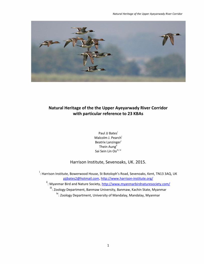
Fig. 1.15. Part of a flock of approximately 30 Grey-headed lapwings (Vanellus cinereus) [LC] seen at the southern entrance to
the Second Defile.
Fig. 1.16. Next page, Top: Southern entrance to the Second Defile. Middle: One of the few villages and patches of agricultural
land within the Second Defile. Bottom: Forest on the limestone hills of the west bank of the Second Defile.

Natural Heritage of the Upper Ayeyarwady River Corridor
21
Natural Heritage of the Upper Ayeyarwady River Corridor
22
Section 5. Ayeyarwady River (Shwegu Section) (KBA 75: High Priority)
[rapid survey: 8-9 February, 2015]
WCS summary, including draft map: http://www.myanmarbiodiversity.org/high_priority_kbas.php?view=Ayeyarwady%20River%20(Shwegu) ; additional map: https://www.google.com/maps/d/viewer?mid=zX7tyH7glOF4.kyW4txdVOm0g&hl=en . IBA 16 criteria: A1, A4i (see Appendix 2 for explanations) IBA 16 summary at http://www.birdlife.org/datazone/userfiles/file/IBAs/AsiaCntryPDFs/Myanmar.pdf and http://www.birdlife.org/datazone/sitefactsheet.php?id=16272 . Background: KBA 75 occupies an area of 373 km2 and comprises a section of the Ayeyarwady River that runs from Shwegu (24° 13.002’N, 96° 48.000’E) in Sagaing Division to south of Tagaung (23° 30.000’N, 96° 00.055’E) in Mandalay Division. It is contained wholly within IBA 16 (Ayeyarwady River (Shwegu Section)). The river valley is broad and in the dry season the river is shallow with many sandbanks (Fig. 1.19). There is local, subsistence agriculture on the riverbanks. From KBA 75, it is possible to see much good forest on the hills (Gangaw Taung) to the west of the river (Fig. 1.19), for example at 23° 57.333’N, 96° 15.807’E. There is considerable confusion over the geographical range of KBA 75 and KBA 4 (Ayeyarwady River (Moda Section))(see below). This latter KBA appears to completely overlap KBA 75 (Fig. 1.8). Probably for this reason, it is not listed in CEPF (2012). Trigger species: KBA 75 supports populations of the Irrawaddy dolphin (Orcaella brevirostris) [CR] and three reptile species: the Burmese Narrow-headed Soft Shell Turtle (Chitra vandijki) [CR]; the Burmese Peacock Soft Shell Turtle (Nilssonia Formosa) [EN]; and the Asiatic Soft Shell Turtle (Amyda cartilaginea) [VU]. According to CEPF (2012), it also supports the globally threatened White-rumped vulture (Gyps bengalensis) [CR].
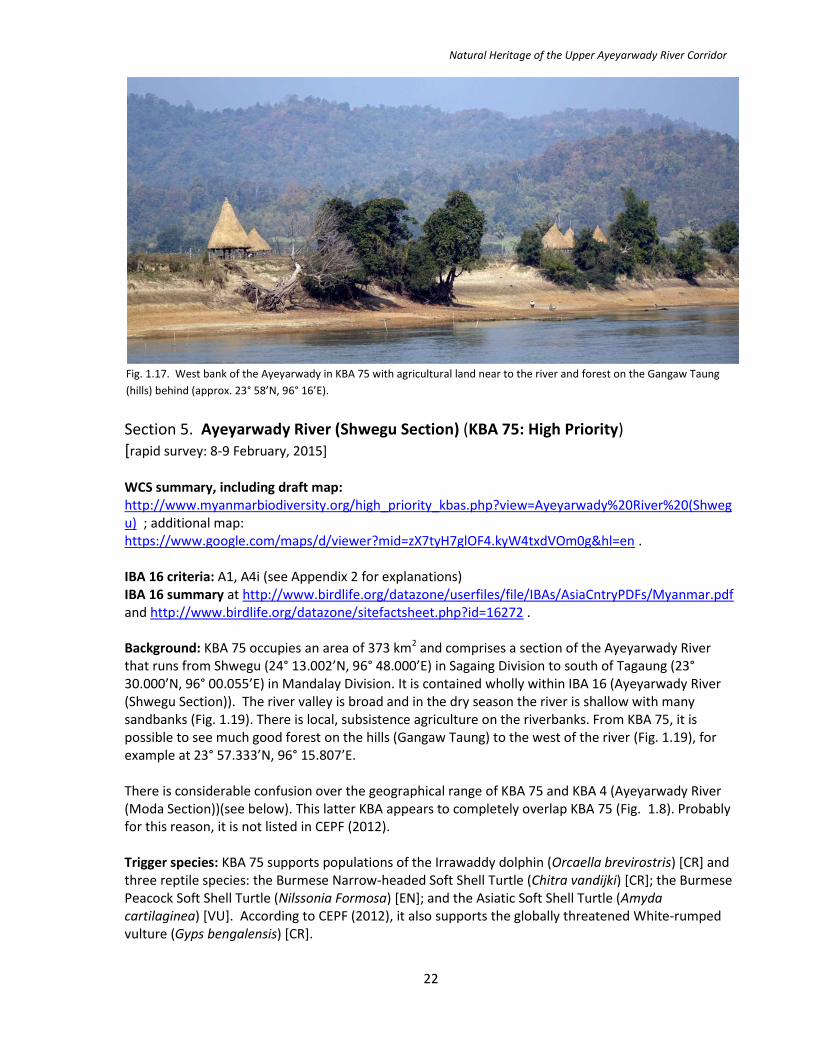
Fig. 1.17. West bank of the Ayeyarwady in KBA 75 with agricultural land near to the river and forest on the Gangaw Taung
(hills) behind (approx. 23° 58’N, 96° 16’E).

Natural Heritage of the Upper Ayeyarwady River Corridor
23
Other wildlife and previous research: During the rapid survey in February, four Irrawaddy dolphin (Orcaella brevirostris) [CR] were observed at 24° 19.808’N, 96° 34.347’E and one at 23° 31.103’N, 96° 00.163’E. Previous records from this area are listed in Smith et al. (1997) and mapped in Fig. 1.28); (Anderson, 1879) suggest that the dolphin was once found in the Shweli River, an Ayeyarwady tributary. Birds seen (Appendix 1) included Oriental darter (An-hinga melanogaster) [NT], Osprey (Pandion haliaetus) [LC], Pallas’s gull (Larus ichthyaetus) [LC], one Asian openbill (Anastomus oscitans) [LC] and approximately 20 Common cranes (Grus grus) [LC] (Fig. 1.19) There were many Ruddy shelduck (Tadorna ferruginea) [LC] and Northern pintail (Anas acuta) [LC]. Little ringed plover (Charadrius dubius) [LC] and especially Small pratincole (Glareola lactea) [LC] were very common. Previously, Smith (1942) (based on records from 1927 and 1929) recorded the Indian skimmer (Rynchops albicollis) [VU] and River tern (Sterna aurantia) [NT] from Tagaung. Observed threats: KBA 75 is not a protected area. There is a large iron and steel plant at Maung Gong (23° 39.103’N, 96° 00.163’E) (Fig. 1.19). A visual inspection appeared to show that there was little obvious pollution or conspicuous environmental damage to the river. There is extensive dumping of garbage into the river, especially adjacent to Shwegu (24° 13.002’N, 96° 48.000’E) (Fig. 1.18). This is the most extreme example of poor waste management seen on the Upper Ayeyarwady. A new road bridge is being built at Htee Kyaint (23° 44.282’N, 96° 09.163’E). Again, the impact does not seem to be particularly detrimental. South of this was a quarry with the mechanised extraction of stone. There is a logging station at approx. 24° 03’N 96° 17’E. An illegal electric fishing boat was seen at night near Tagaung, very close to where an Irrawaddy dolphin was also observed in the evening (23° 31.395’N, 96° 00.033’E). Near to Shwegu, a couple were observed panning for gold. Elsewhere, we also observed some very simple, low technology, sifting of gravels for gold. This gold extraction does not appear to have a measurable environmental impact. Recommendations: A study of water quality downstream from the iron and steel plant at Maung Gong (23° 39.103’N, 96° 00.163’E) is a priority. As with KBA 4, a more detailed survey of bird diversity and population size, together with a follow-up survey on the Irrawaddy dolphin (Orcaella brevirostris) [CR] would also be valuable.
Fig. 1.18. Household waste dumped on the Ayeyarwady River bank near Shwegu.

Natural Heritage of the Upper Ayeyarwady River Corridor
24
Fig. 1.19. Top: An iron and steel plant at Maung Gong. Middle: In many areas, the river is broad with numerous sandbanks.
Middle: A picturesque village on the river bank. Bottom: Part of a flock of 20 Common cranes (Grus grus) [LC] and an Oriental
darter (Anhinga melanogaster) [NT] on the river bank of KBA 75.

Natural Heritage of the Upper Ayeyarwady River Corridor
25
Section 6. Ayeyarwady River (Moda Section) (KBA 4: High Priority) [rapid survey: 10-12 February, 2015] WCS summary, including draft map: http://www.myanmarbiodiversity.org/high_priority_kbas.php?view=Ayeyarwady%20River%20(Moda%20Section) ; additional map: https://www.google.com/maps/d/viewer?mid=zX7tyH7glOF4.kyW4txdVOm0g&hl=en . IBA 16 criteria: A1, A4i (see Appendix 2 for explanations) IBA 16 summary at http://www.birdlife.org/datazone/userfiles/file/IBAs/AsiaCntryPDFs/Myanmar.pdf and http://www.birdlife.org/datazone/sitefactsheet.php?id=16272 . Background: As noted above, there is considerable confusion over the status and extent of KBA 4. Although a riparian KBA and therefore by definition restricted to the course of the river and the riverbanks (see introduction above), it is mapped as a broad KBA with an area of 302.9 km2, that covers much of the surrounding hinterland (WCS, 2012). It is also shown to completely overlap KBA 75 (Fig. 1.8). Probably for this reason, it is not listed in CEPF (2012). Trigger species: According to WCS (2012), these comprise the Irrawaddy dolphin (Orcaella brevirostris) [CR], the Burmese Narrow-headed Soft Shell Turtle (Chitra vandijki) [CR], the Burmese Peacock Soft Shell Turtle (Nilssonia formosa) [EN], and the Asiatic Soft Shell Turtle (Amyda cartilaginea) [VU]. According to WCS (2012), KBA 4 may also support the globally threatened White-rumped vulture (Gyps bengalensis) [CR] and congregatory water birds including Cotton pygmy goose (Nettapus coromandelianus ) [LC]. Other wildlife and previous research: Our survey records are listed above for KBA 75. Conservation status and observed threats: KBA 4 is not a protected area. Threats are listed above for KBA 75. Recommendations: There is a need to clarify the status of KBA 4.
Fig. 1.20. The small town of Htee Kyaint (22° 45’N, 96° 09’E). There are relatively few towns seen on the Ayeyarwady between
Mandalay and Bhamo.
http://www.myanmarbiodiversity.org/high_priority_kbas.php?view=Ayeyarwady%20River%20(Moda%20Section)

Natural Heritage of the Upper Ayeyarwady River Corridor
26
Section 7. Ayeyarwady River (Tagaung to Thabeikkyin) [rapid survey: 6-7 February, 2015]
Background: This section of the river is neither a KBA nor an IBA. It runs from Tagaung (23° 30.000’N, 96° 00.055’E) south to the northern entrance to the Third Defile, which is just north of Thabeikkyin (22° 52.867’N, 95° 58.217’E). Like the northern section of the Third Defile, the river runs north-south, almost in a straight line. However, it is broader and in the dry season there are many sandbanks (Figs. 1.21 and 1.22). There are low hills on the west bank, particularly from 23° 03.300’N (near Male) to 22° 04.300’N (just north of Thabeikkyin) (Fig. 1.21). These are covered with dry secondary deciduous forest. Otherwise the river banks are fringed with isolated small villages, which practice subsistence agriculture. Trigger species: There are no trigger species since the area is neither a KBA nor an IBA. Other wildlife and previous research: The sandbanks are home to many congregatory waterbirds including Ruddy shelduck (Tadorna ferruginea) [LC] and Eastern spot-billed duck (Anas zonorhyncha) [LC]. There were Small pratincole (Glareola lactea) [LC]. Barn swallow (Hirundo rustica) [LC] and Red-rumped swallow (Cecropis daurica) [LC] were particularly common. Other species seen included a flight of four Common cranes (Grus grus) [LC] and a single individual of Black stork (Ciconia nigra) [LC]. We had a possible sighting of a River tern (Sterna aurantia) [NT] (Appendix 1). Conservation status and observed threats: Threats include the on-going disturbance of sandbanks by man, cattle and dogs and agricultural development of most of the lowland areas (Fig. 1.22). Recommendations: As with all sections of the river with extensive sandbanks, in the least populated areas, there are opportunities to promote conservation of nesting birds by reducing threats, especially disturbance by man, cattle and dogs.
Fig. 1.21. In the southern part of Section 7 of the Ayeyarwady River, near Thabeikkyin, there are low, forested hills on the
west bank. Sandbanks are numerous in all parts of the section.

Natural Heritage of the Upper Ayeyarwady River Corridor
27
Fig. 1.22. Top: Eastern spot-billed duck (Anas zonorhyncha) [LC] are common on the sandbanks. Middle: Cattle crossing the
Ayeyarwady River. Middle: Sandbanks near the town of Tagaung. Below: A raft of bamboo floating down the Ayeyarwady.

Natural Heritage of the Upper Ayeyarwady River Corridor
28
Section 8. Ayeyarwady River (Third Defile) [rapid survey: 6 February, 2015] Background: The Third Defile is neither a KBA nor an IBA. It is a gorge whose northern entrance is situated slightly to the north of Thabeikkyin (22° 52.867’N, 95° 58.217’E). From here it runs for 15 km, almost due south, until it deviates sharply to the west before resuming its southerly course. The deviation is caused by a volcanic Holocene lava sheet of some 62 km2, which is today known as the Singu Plateau, or Letha Taung (Chhibber, 1933). The southern exit from the Defile is at Kyaukmyaung (22° 34.767’N, 95° 57.740’E). Low hills are present on both sides. They are covered with dry, deciduous, highly disturbed forest. There are a few isolated settlements and a limited amount of subsistence agriculture on the margins of the river. Trigger species: There are no trigger species since the area is neither a KBA nor an IBA. Other wildlife and previous research: Many Ashy wood-swallow (Artamus fuscus) [LC] were observed near Anya Thiha Taw pagoda (Fig. 1.24). Barn swallow (Hirundo rustica) [LC] and Red-rumped swallow (Cecropis daurica) [LC] were especially common. Conservation status and observed threats: None of the area is protected. There was extensive extraction of gravels for processing for gold on the east bank of the river at 22° 44.075’N, 95° 55.910’E and a smaller gold extraction operation at 22° 50.192’N, 95° 58.067’E (Fig. 1.24). Recommendations: It would be important to assess the impact of the gold extraction activities on water quality.
Fig. 1.23. Looking north into the north-south section of the Third Defile, as it starts to deviate to the west around the
Holocene lava sheet.
Fig. 1.24. Next page. Top: Ashy wood-swallow (Artamus fuscus) [LC] are common near the Thiha Taw pagoda (22° 50.660’N,
95° 58.075’E). Middle: Looking south down the Third Defile from the Anya Thiha Taw pagoda. Middle: Ancient lava, part of
the Singu Plateau Below: Washing out gravels for processing for gold on the east bank of the river at 22° 44.075’N, 95°
55.910’E.

Natural Heritage of the Upper Ayeyarwady River Corridor
29

Natural Heritage of the Upper Ayeyarwady River Corridor
30
Section 9. Ayeyarwady River (Singu Section) (KBA 7: High Priority) [rapid survey: 5 February, 2015] WCS summary, including draft map: http://www.myanmarbiodiversity.org/high_priority_kbas.php?view=Ayeyarwady%20River%20(Singu%20Section) ; additional map: https://www.google.com/maps/d/viewer?mid=zX7tyH7glOF4.kyW4txdVOm0g&hl=en . IBA 21 criteria: A4i, A4iii (see Appendix 2 for explanations) IBA 21 summary at http://www.birdlife.org/datazone/userfiles/file/IBAs/AsiaCntryPDFs/Myanmar.pdf and http://www.birdlife.org/datazone/sitefactsheet.php?id=16273 . Background: KBA 7, which overlaps IBA 21 (of the same name), is a section of the Ayeyarwady River and extends from Kyaukmyaung (22° 34.767’N, 95° 57.740’E) in Sagaing Division to a point a few km to the south of the small fishing village of Singu (22° 33’N, 95° 59’E) (Fig. 1.26), which lies on the east bank of the river in Mandalay Division, some 7 km south of Kyaukmyaung. The KBA has an area of 74.6 km2 (WCS, 2012). In the field, there is no clear division between this small KBA and the larger KBA 85 (Irrawaddy dolphin protect area) to the south. The river and surrounding area is unremarkable. The channel of the river broadens to the south but lacks the braiding seen elsewhere. There are two towns on the riverbanks, Kyaukmyaung and Singu, the former is quite sizeable. Elsewhere, there is agriculture on the river banks. Trigger species: According to WCS (2012), KBA 7 supports populations of Irrawaddy dolphin (Orcaella brevirostris) [CR]; three reptile species: the Burmese Narrow-headed Soft Shell Turtle (Chitra vandijki) [CR]; the Burmese Peacock Soft Shell Turtle (Nilssonia formosa) [EN]; and the Asiatic Soft Shell Turtle (Amyda cartilaginea) [VU] and possibly two catfish species: a giant catfish (Rita rita) [LC] and the Silong catfish (Silonia silondia) [LC]. Other wildlife and previous research: KBA 7 is reported to support congregatory waterbird species including Bar-headed goose (Anser indicus) [LC] – 221 individuals in 1992; Greylag goose (Anser anser) [LC] – 1,500 individuals in 1992; and Ruddy shelduck (Tadorna ferruginea) [LC] – 894 individuals in 1992 (Birdlife, International 2015). However, during the current surveys, no bird species of particular interest were observed. In May, 2015 there was a sighting of two Irrawaddy dolphins (Orcaella brevirostris) [CR] at approx. 22° 35.750’N, 95° 57.400’E. Conservation status and observed threats: KBA 7 is not a protected area. In May, 2014, river gravels were being washed for gold, opposite Kyaukmyaung (22° 34.767’N, 95° 57.740’E). This was a small enterprise. Otherwise, no particular threats were observed.
Fig. 1.25. The Ayeyarwady River near Singu.
Natural Heritage of the Upper Ayeyarwady River Corridor
31
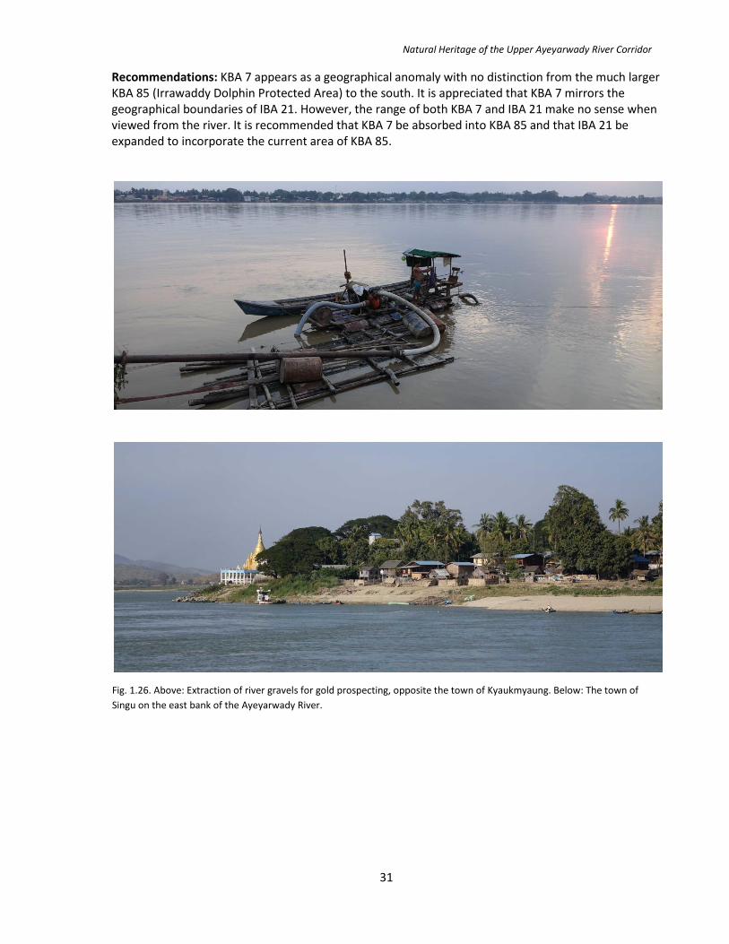
Recommendations: KBA 7 appears as a geographical anomaly with no distinction from the much larger KBA 85 (Irrawaddy Dolphin Protected Area) to the south. It is appreciated that KBA 7 mirrors the geographical boundaries of IBA 21. However, the range of both KBA 7 and IBA 21 make no sense when viewed from the river. It is recommended that KBA 7 be absorbed into KBA 85 and that IBA 21 be expanded to incorporate the current area of KBA 85.
Fig. 1.26. Above: Extraction of river gravels for gold prospecting, opposite the town of Kyaukmyaung. Below: The town of
Singu on the east bank of the Ayeyarwady River.

Natural Heritage of the Upper Ayeyarwady River Corridor
32
Section 10. Ayeyarwady River (Irrawaddy Dolphin Protected Area) (KBA 85) [rapid surveys: 14-16 May, 2014; 3-5 February, 2015; 7-12 May, 2015]. WCS summary, including draft map: http://www.myanmarbiodiversity.org/high_priority_kbas.php?view=Irrawaddy%20Dolphin%20P.A ; additional map: https://www.google.com/maps/d/viewer?mid=zX7tyH7glOF4.kyW4txdVOm0g&hl=en Background: KBA 85 covers 50 km of the Ayeyarwady River from a point just south of Singu (22° 33’N, 95° 59’E) to near the historic town of Mingun (22° 03.060’N, 96° 01.260’E), a short distance north-west of Mandalay. According to WCS (2012), it has an area of 326.4 km2. The river is extensively braided, comprising numerous channels, many of which become impassable in the dry season. There are extensive sandbanks. With the exception of some forest remnants at Tawyagyi Wildlife Sanctuary (KBA 122) (see decription below) the margins of the river are farmed for agriculture, particularly for peanuts, rice and maize. Mingun Taung comprises the only hills of any particular size and altitude that are adjacent to the river. It is situated on the west bank of the river stretching to the north and south of Mingun (22° 03.060’N, 96° 01.260’E). Trigger species: KBA 85 supports populations of the Irrawaddy dolphin (Orcaella brevirostris) [CR] and three species of reptile, the Burmese Narrow-headed Soft Shell Turtle (Chitra vandijki ) [CR], the Burmese Peacock Soft Shell Turtle (Nilssonia Formosa) [EN], and the Asiatic Soft Shell Turtle (Amyda cartilaginea) [VU] (WCS, 2012). Other wildlife and previous research: A comprehensive study of the Irrawaddy dolphin (Orcaella brevirostris) [CR] was conducted in this area (and to the north) in March/April and December, 1996. Sightings are listed in Smith et al. (1997) and plotted in Fig. 1.28. Much information about the dolphin, including its interactive behaviour with local fishermen is provided in this paper. Smith et al. (1997, 2003) report a >50% decline in the range of this species in the Ayeyarwady, with none found in the river south of Mingun. According to Anderson (1879), previously, it was known from as far south as Pyay (= Prome). Population numbers were thought to be <60 individuals (Smith, 2004) and 72 individuals (Smith et al., 2007).
Fig. 1.27. Agricultural land adjacent to the Ayeyarwady River in KBA 85.

Natural Heritage of the Upper Ayeyarwady River Corridor
33
Fig. 1.28. Map of Irrawaddy dolphin (Orcaella brevirostris) [CR] sightings by the project team in February and
May, 2015 (in black). Previous records in March/April and December, 1996 included in Smith et al. (1997) are
shown in blue for comparison. Smith et al. (1997) did not find the dolphin south of Mingun (near Mandalay). In
the currentl project, we did not survey for dolphin between Mandalay and Bagan.
May 2015, 22° 35.750’N, 95° 57.362’E
May 2015, 22° 29.192’N, 96° 00.423’E
May 2015, 22° 25.855’N, 96° 01.161’E
May 2015 22° 24.833’N, 95° 59.650’E
Feb and May 2015 approx. 22°22’N, 96° 00’E
May 2015 22° 20.690’N, 95° 59.290’E
Feb 2015 22° 14.858’N, 96° 01.161’E
Feb 2015, 23° 31.103’N, 96° 00.163’E
Feb 2015, 24° 19.808’N, 96° 34.347’E
Feb 2015, 24° 10.160’N, 97° 10.222’E
Dec 1996, 23° 54.5’N, 96° 16.0’E
Dec 1996, approx. 23° 33.5’N, 96° 00.0’E
Dec 1996, 23° 27.0’N, 96° 00.6’E
Dec 1996, approx. 23° 26.7’N, 96° 01.0’E
Dec 1996, 22° 28.6’N, 95° 59.6’E
Mar/Apr 1996, approx. 22° 24.3’N, 96° 00.1’E
Dec 1996, 22° 16.1’N, 96° 00.9’E
Dec 1996, 22° 11.6’N, 96° 01.4’E
Mar/Apr 1996, 22° 09.4’N, 96° 00.9’E
Dec 1996, 22° 08.6’N, 96° 00.0’E
Mar/Apr 1996, 22° 02.9’N, 96° 01.9’E
Natural Heritage of the Upper Ayeyarwady River Corridor
34
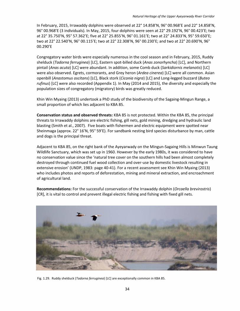
In February, 2015, Irrawaddy dolphins were observed at 22° 14.858’N, 96° 00.968’E and 22° 14.858’N, 96° 00.968’E (3 individuals). In May, 2015, four dolphins were seen at 22° 29.192’N, 96° 00.423’E; two at 22° 35.750’N, 95° 57.362’E; five at 22° 25.855’N, 96° 01.161’E; two at 22° 24.833’N, 95° 59.650’E; two at 22° 22.540’N, 96° 00.115’E; two at 22° 22.308’N, 96° 00.230’E; and two at 22° 20.690’N, 96° 00.290’E Congregatory water birds were especially numerous in the cool season and in February, 2015, Ruddy shelduck (Tadorna ferruginea) [LC], Eastern spot-billed duck (Anas zonorhyncha) [LC], and Northern pintail (Anas acuta) [LC] were abundant. In addition, some Comb duck (Sarkidiornis melanotis) [LC] were also observed. Egrets, cormorants, and Grey heron (Ardea cinerea) [LC] were all common. Asian openbill (Anastomus oscitans) [LC], Black stork (Ciconia nigra) [LC] and Long-legged buzzard (Buteo rufinus) [LC] were also recorded (Appendix 1). In May (2014 and 2015), the diversity and especially the population sizes of congregatory (migratory) birds was greatly reduced. Khin Win Myaing (2013) undertook a PhD study of the biodiversity of the Sagaing-Mingun Range, a small proportion of which lies adjacent to KBA 85.
Conservation status and observed threats: KBA 85 is not protected. Within the KBA 85, the principal threats to Irrawaddy dolphins are electric fishing, gill nets, gold mining, dredging and hydraulic land blasting (Smith et al., 2007). Five boats with fishermen and electric equipment were spotted near Sheinmaga (approx. 22° 16’N, 95° 59’E). For sandbank nesting bird species disturbance by man, cattle and dogs is the principal threat. Adjacent to KBA 85, on the right bank of the Ayeyarwady on the Mingun-Sagaing Hills is Minwun Taung Wildlife Sanctuary, which was set up in 1960. However by the early 1980s, it was considered to have no conservation value since the ‘natural tree cover on the southern hills had been almost completely destroyed through continued fuel wood collection and over-use by domestic livestock resulting in extensive erosion’ (UNDP, 1983: page 40-41). For a recent assessment see Khin Win Myaing (2013) who includes photos and reports of deforestation, mining and mineral extraction, and encroachment of agricultural land. Recommendations: For the successful conservation of the Irrawaddy dolphin (Orcaella brevirostris) [CR], it is vital to control and prevent illegal electric fishing and fishing with fixed gill nets.
Fig. 1.29. Ruddy shelduck (Tadorna ferruginea) [LC] are exceptionally common in KBA 85.

Natural Heritage of the Upper Ayeyarwady River Corridor
35
Fig. 1.30. Top: Northern pintail (Anas acuta) [LC] were commonly seen in KBA 85. Middle: A flight of Eastern spot-billed duck
(Anas zonorhyncha) [LC] and Comb duck (Sarkidiornis melanotis) [LC]. Middle: Ruddy shelduck (Tadorna ferruginea) [LC] were
seen on most sandbanks/shallow water areas of KBA 85. Middle: Cormorants (Phalacrocoracidae) were numerous. Below: A
typical sight on many sandbanks, here the water birds include Ruddy shelduck (Tadorna ferruginea) [LC], Eastern spot-billed
duck (Anas zonorhyncha) [LC], Great cormorant (Phalacrocorax carbo) [LC], Little cormorant (P. niger) [LC], Great egret (Ardea
alba) [LC] and Little egret (Egretta garzetta) [LC].

Natural Heritage of the Upper Ayeyarwady River Corridor
36
Section 11. Ayeyarwady River (Mingun to Pakokku) [rapid surveys: Mingun to Sagaing May and August, 2014, February and May, 2015; Sagaing to Pakokku not visited]. Background: This section is neither a KBA nor an IBA. The river runs from Mingun (22° 03.060’N, 96° 01.260’E) south to Pakokku (21° 22’N, 95° 08’E). The area is a broad open river valley with extensive sandbanks. The Chindwin joins the Ayeyarwady as a series of rather inconspicuous channels in this section at about 21° 27’N, 95° 15’E. There are no upland areas. The river banks are home to village communities, which are surrounded by agricultural land. Trigger species: There are no trigger species since the area is neither a KBA nor an IBA. Other wildlife and previous research: In May, 2014, many Oriental pratincoles (Glareola maldivarum) were observed on the sand banks between Mandalay city and Sagaing. Meanwhile, Khin Win Myaing (2013) undertook a PhD study of the Sagaing-Mingun Range, a proportion of which lies adjacent to KBA 85. She included a number of camera trap records (Photo 9) of small carnivores and deer, which appear to show Common palm civet (Paradoxurus hermaphroditus) [LC], and possibly a Large-toothed ferret-badger (Melogale personata) [DD] and a melanistic Asian golden cat (Catopuma temminckii) [NT] together with a small deer (not identified) and a python. Wood and Finn (1902) included some bird records from Pakokku. Conservation status and observed threats: For information on Minwun Taung Wildlife Sanctuary, which partly occurs in this area see comments above for the previous river section (Section 10). Recommendations: In view of the limited information available in either published or unpublished format, it would be valuable to conduct a biodiversity survey of this area. The interesting camera trap photos of Khin Win Myaing (2013), with near-threatened and data deficient species (see comments above) suggest that adjacent forest of the Mingun-Sagaing hills should be surveyed in more detail.
Fig. 1.31. Mingun on the west bank of the Ayeyarwady north of Mandalay.

Natural Heritage of the Upper Ayeyarwady River Corridor
37
Fig. 1.32. Top: Ayeyarwady River at Mandalay in October, 2014. Middle: Sagaing Hills. Below: Mingun-Sagaing Taung (hills),
between Sagaing and Mandalay in May, 2014.

Natural Heritage of the Upper Ayeyarwady River Corridor
38
Section 12. Ayeyarwady River (Bagan Section) (KBA 2) [rapid surveys: only of the area directly adjacent to Bagan - August and November, 2014] WCS summary, including draft map: http://www.myanmarbiodiversity.org/high_priority_kbas.php?view=Ayeyarwady%20River%20(Bagan%20Section) ; additional map: https://www.google.com/maps/d/viewer?mid=zX7tyH7glOF4.kyW4txdVOm0g&hl=en . IBA 27 criteria: A1, A4i, A4iii (see Appendix 2 for explanations) IBA 27 summary at http://www.birdlife.org/datazone/userfiles/file/IBAs/AsiaCntryPDFs/Myanmar.pdf and http://www.birdlife.org/datazone/sitefactsheet.php?id=16287 . Background: KBA 2 covers 342.3 km2 of the Ayeyarwady River between Pakokku (21° 22’N, 95° 08’E) and Lan Ywar (20° 57’N, 94° 50’E). It has an average elevation of 50 m a.s.l. and stretches some 25 km either side of the ancient city of Bagan. It slightly exceeds in size IBA 27, which is totally subsumed within it. It straddles the border between Magway and Mandalay Divisions.
Trigger species: These include three reptile species, the Burmese Narrow-headed Soft Shell Turtle (Chitra vandijki )[CR], the Burmese Peacock Soft Shell Turtle (Nilssonia formosa) [EN], and the Asiatic Soft Shell Turtle (Amyda cartilaginea) [VU] and two bird species, for which it was awarded IBA status, namely Greater Spotted eagle (Clanga clanga) [VU] and the Indian skimmer (Rynchops albicollis) [VU].
Other wildlife and previous research: The record of Greater Spotted eagle (Clanga clanga) [VU] by the Ayeyarwady River, Bagan was made by S. Chan in February, 2001 (Birdlife International, 2001). The record of the Indian skimmer (Rynchops albicollis) [VU] was based on a sighting of 3 individuals in 1995 (Robson et al. 1998); this species was formerly found on all major river systems in Myanmar (Hume and Davidson, 1878; Oates, 1882; Harington, 1909-10; Smythies, 1986; Birdlife International, 2001). There are very few recent sightings in Myanmar (BirdLife International, 2013) and none from Bagan. According to Birdlife (2012), congregatory bird species include the Bar-headed goose (Anser indicus) [LC]. Many bird species were recorded during a field survey in November, 2014 including congregatory ducks, birds of prey and a variety of passerines (Appendix 1). Previously, the Irrawaddy dolphin (Orcaella brevirostris) [CR] were recorded from the Bagan area but have not been observed in recent
Fig. 1.33. Ayeyarwady River, north-east of Bagan, showing extensive sandbanks (November, 2014).

Natural Heritage of the Upper Ayeyarwady River Corridor
39
times (Smith et al., 1997). Two huge colonies of Indian flying fox (Pteropus giganteus) roost on trees on the river bank at Nyaung Oo (this study) and 10 km south of Bagan at Nyaung Hla (Bates et al., 2000). Conservation status and observed threats: KBA 2 is not a protected area. There is some on-going human disturbance. Recommendations: There is a need for more detailed wildlife surveys in this section of the Ayeyarwady River. A study of the current status of the Indian skimmer (Rynchops albicollis) [VU] would be particularly valuable. A reappraisal of the threats is also important.
Fig. 1.34. Top: View of a side channel of the Ayeyarwady River at Lawkananda Pagoda (November, 2014). Middle:
Ayeyarwady River, near Naung Oo, taken facing west from 24° 12.500’N, 94° 56.383’N. Below: Ayeyarwady River, taken facing
south at Old Bagan (24° 10.600’N, 94° 51.450’N) in August, 2014.

Natural Heritage of the Upper Ayeyarwady River Corridor
40
1.4.2 Key Biodiversity Areas directly adjacent to the Ayeyarwady River
Sheinmaga Tawyagyi (KBA 122: High Priority) [rapid survey: 14-15 May, 2014]. WCS summary, including draft map: http://www.myanmarbiodiversity.org/high_priority_kbas.php?view=Sheinmaga%20Tawyagyi ; additional map: https://www.google.com/maps/d/viewer?mid=zX7tyH7glOF4.kyW4txdVOm0g&hl=en Background: KBA 122 comprises Tawyagyi Wildlife Sanctuary (c.o. 22° 16’N, 95° 59’E), which was founded by King Mindon in 1852 and is Myanmar's oldest protected area (Fig. 1.35). It has an area of 0.44 km2 and is located midway between Kyaukmyaung and Mingun on the west bank of the Ayeyarwady River, some 40 km north of Mandalay. The vegetation is dry broad leaf forest, which has a ‘regionally outstanding biological distinctiveness’ and a conservation status of ‘critical’ (Wikramanayake et al., 2002). Elsewhere, this biome is under intense threat and has been extensively deforested with land converted to agricultural and urban use. Trigger species: The sanctuary is home to a small population (approx. 30 individuals) of Eld’s deer (Rucervus eldii) [EN] (also known as Thamin, referring to the local subspecies, R. e. thamin) (Fig. 1.36). Other subspecific populations are found in India (R. e. eldii), and Cambodia, China, Lao P.D.R., and Thailand (R. e. siamensis) (Balakrishnan et al., 2003, Gray et al., 2015). The key reptile species present is the Yellow-headed tortoise, Indotestudo elongata [EN]. Other wildlife and previous research: The distribution (and decline) of Eld’s deer (Rucervus eldii) [EN] in Myanmar is summarised in Christison (1945), Salter and Sayer (1986), McShea et al. (1999), and Koy et al. (2005). The forest is home to many bird species, including two, the hooded treepie (Crypsirina cucullata) [NT] and White-throated babbler (Turdoides gularis) [LC], which are endemic to Myanmar. It is also home to small carnivores like Asian golden cat (Catopuma tem-minckii) [NT] and leopard cat (Prionailurus bengalensis) [LC] (http://www.growbackposterity.com/).
Fig. 1.35. The entrance to Tawyagyi Wildlife Sanctuary, which was founded in 1852 by King Mindon (photo taken in May,
2014).

Natural Heritage of the Upper Ayeyarwady River Corridor
41
Conservation status and observed threats: KBA 122 receives some formal protection from the Forestry Department who have recently started to enforce laws prohibiting the illegal grazing of cattle and deforestation within the sanctuary (Aung Myo Chit, pers. comm. and Fig. 1.37). The Myanmar CSO ‘Grow Back for Posterity’, http://www.growbackposterity.com/ , is participating in a number of conservation programmes, including reforestation, and surveying and monitoring wildlife within the sanctuary. The abbott and monks of Tawyagyi Monastery have a moral authority, which also helps with wildlife conservation. They assist with promoting reforestation programmes and trying to eliminate poaching. However, a recent article in the Myanmar media, reporting on the hunting of an Eld’s deer within the sanctuary, shows that this is not always successful. Recommendations: The sanctuary needs income to assist with its development. It is an ideal area for community-based conservation and currently on-going discussions are taking place in order to achieve such a programme. Meanwhile, it would benefit from comprehensive biodiversity surveys in order to accurately list the bird, mammal and reptile species (amongst others) found within its borders.
Fig. 1.36. There are some 30+ Eld’s deer (Rucervus eldii) [EN] in Tawyagyi Wildlife Sanctuary. The individuals photographed
above are part of a small captive at Lawkananda Wildlife Sanctuary, Bagan.

Natural Heritage of the Upper Ayeyarwady River Corridor
42
Fig. 1.37. Above: Tawyagyi Wildlife Sanctuary from the Ayeyarwady River. Middle: Notice boards posted by the Forest
Department, with the rules and regulations of the Sanctuary. Below: Painted sticks mark small trees which is part of the
reforestation programme for the wildlife sanctuary by the in-country CSO, ‘Grow Back for Posterity’.

Natural Heritage of the Upper Ayeyarwady River Corridor
43
1.4.3 Other KBAs within or near to the Upper Ayeyarwady River Corridor Chatthin (Kyatthin) Wildlife Sanctuary (KBA 12: Medium Priority) [not visited] WCS summary, including draft map: http://www.myanmarbiodiversity.org/medium_priority_kbas.php?view=Chatthin%20W.S ; additional map: https://www.google.com/maps/d/viewer?mid=zX7tyH7glOF4.kyW4txdVOm0g&hl=en IBA 18 criteria: A1, A2, A3, A4i (see Appendix 2 for explanations) IBA 18 summary at http://www.birdlife.org/datazone/userfiles/file/IBAs/AsiaCntryPDFs/Myanmar.pdf and http://www.birdlife.org/datazone/sitefactsheet.php?id=16271 . Background: KBA 12 covers the same area as IBA 18 and corresponds to the boundaries of Chatthin (Kyatthin) Wildlife Sanctuary, which was created in September, 1941. It lies between the Ayeyarwady and Mu rivers, west of the Myitkyina-Sagaing railway at 23° 30’ - 23° 42’N, 95° 24’ - 95° 40’E; its centre is some 20 km east of the village of Ywagongyi in Sagaing Division. Its area is given as 269.4 km2 or 284.0 km2 (WCS, 2012). KBA 12 primarily comprises seasonal or ‘monsoonal’ forest dominated by a slow-growing large-leaved species of deciduous dipteroccarp hardwood (Dipterocarpus tuberculatus), together with Shorea oblongifolia and Pentacme siamensis. This is also known as ‘indaing forest’. As such, it is a remnant of the vast dipterocarp woodlands that once covered Myanmar’s central zone. Today, the sanctuary is largely a matrix of secondary growth forest scattered with grasslands (Wemmer et al., 2000). The area is generally flat to gently undulating with an average elevation of about 180-200 m a.s.l. with a maximum of 244 m. Depressions centred on the drainage courses are flooded during the rains but dry up into extensive grassy plains (lwins) and isolated pools during the dry season. A number of natural salt licks used by wildlife are scattered throughout the sanctuary (Salter and Sayer, 1983). Trigger species: KBA 12 supports the largest population of Eld’s deer (Rucervus eldii) [EN] in Myanmar (Fig. 1.36). Population levels in 1983 were estimated at 2000 but have probably declined greatly in recent years (McShea et al., 1999; Wemmer et al., 2000). The principal reptile species are the Yellow-headed tortoise (Indotestudo elongata) [EN] and the Asiatic Soft Shell Turtle, Amyda cartilaginea [VU]. The White-winged duck (Asarcornis scutulata) [EN] was thought to possibly occur in the Chatthin Wildlife Sanctuary but there are no recent reports (Birdlife International, 2001). Other species reported include the Spot-billed pelican (Pelecanus philippensis) [NT], which was listed in http://www.birdlife.org/datazone/sitefactsheet.php?id=16271 as ‘non-breeding – 2004’ for Chatthin Wildlife Sanctuary. This species was once widely distributed throughout Myanmar (Birdlife International, 2001). It was recorded from the Ayeyarwady by Stanford and Ticehurst (1938-39) and Stanford (1954). Baker (1922-1930) suggested that it bred in huge numbers in at least one area. However, Smythies (1986) suggested that it no longer bred and seemed to occur in only small numbers. Now, it is thought to be no longer found in Myanmar (BirdLife International, 2012). A flock of 65 Lesser Whistling-duck, Dendrocygna javanica [LC] were reported from Chatthin by Salter and Sayer (1983). Other wildlife and previous research: According to Salter and Sayer (1983), the forest was home to species such as Wild dog (Cuon alpinus) [EN], Leopard (Panthera pardus) [NT], Hog deer (Axis porcinus)
Natural Heritage of the Upper Ayeyarwady River Corridor
44
[EN], Sambar (Rusa unicolor) [VU], and Banteng (Bos javanicus) [EN]. However, the more recent publication of Aung et al. (2004) suggests that there has been a dramatic decline in large mammal species. Ninety-four bird species were listed by Salter and Sayer (1983). General literature on the Chatthin (Kyatthin) Wildlife Sanctuary includes Salter and Sayer (1983), Wemmer (2000), Aung et al. (2004), and IUCN (1985 and 1987). Literature on Myanmar’s Eld’s deer (Rucervus eldi thamin) includes Christison (1945), Salter and Sayer (1986), McShea et al. (1999). A provisional list of birds is included in Salter and Sayer (1983) and Nay Myo Shwe et al. (1999). Bird research was carried out in the sanctuary by King and Rappole (2001). Conservation status and observed threats: KBA 12 is protected. However, Salter and Sayer (1983) noted that there is on-going poaching/harvesting of wildlife by local people including deer, tortoises, soft-shelled turtles and many birds, small mammals and reptiles. Aung et al. (2004) stated that with the removal of predators, the sanctuary has become over-grazed by cattle and degraded by the human extraction of forest products. Since we did not visit the KBA, the current status is not known to us. Recommendations: The historical list of species known from the sanctuary suggests that this is potentially a very important site for conservation. There is a clear need to assess the current species diversity and determine the current level of threats to the wildlife and habitats with a view to drawing up a meaningful and credible management plan.

Natural Heritage of the Upper Ayeyarwady River Corridor
45
Mahamyaing Wildlife Sanctuary (KBA 35: Medium Priority) [not visited] WCS summary, including draft map: http://www.myanmarbiodiversity.org/medium_priority_kbas.php?view=Mahamyaing%20W.S ; additional map: https://www.google.com/maps/d/viewer?mid=zX7tyH7glOF4.kyW4txdVOm0g&hl=en IBA 19 criteria: A1 (see Appendix 2 for explanation) IBA 19 summary at http://www.birdlife.org/datazone/userfiles/file/IBAs/AsiaCntryPDFs/Myanmar.pdf and http://www.birdlife.org/datazone/sitefactsheet.php?id=16314 . Background: KBA 35, with a land area of 1203.9 km2 (WCS, 2012), follows approximately the same geographical boundaries as IBA 19, which according to Birdlife International (2015), has a land area of 1,000 km2 and is centred on 23°18’N 94°44’E. KBA 35 comprises most of the slightly larger Mahamyaing Wildlife Sanctuary, which has a land area of 1180.39 km2. Birdlife International (2015) provides a digital map but no other details. Rao et al. (2002) suggested that the sanctuary, which was proposed in 1998, would have an area of 3354 km2. KBA 35 is situated in the ‘Irrawaddy moist deciduous forest (‘indaing forest’) belt’ of central Myanmar (Wikramanayake et al., 2002) to the east of the Chindwin River in south central Sagaing Division. It has an average elevation of 150 m a.s.l. Trigger species: According to WCS (2012), these apparently include the globally threatened Green peafowl (Pavo muticus) [EN] and mammal species such as Asian elephant (Elephas maximus) [EN], Banteng (Bos javanicus) [EN], Chinese pangolin (Manis pentadactyla) [CR], Dhole (Cuon alpinus) [EN], Eastern Hoolock gibbon (Hoolock leuconedys) [VU], Himalayan Black bear (Ursus thibetanus) [VU], Sambar (Rusa unicolor) [VU], and Sunbear (Helarctos malayanus) [VU]. The principal reptile species is the Yellow-headed tortoise (Indotestudo elongata) [EN] and the key plant species is the Amboine, or Burmese Rosewood , (Pterocarpus indicus) [VU]. However, a survey of the Sanctuary undertaken in 1999 found no record of elephant or sunbear (WCS, 2000). Other wildlife and previous research: According to WCS (2000), large mammal species included (amongst others) Clouded leopard (Neofelis nebulosa) [VU], Asian golden cat (Catopuma temminckii) [NT], Leopard cat (Prionailurus bengalensis) [LC], Asian dhole (Cuon alpinus) [EN], Sunbear (Helarctos malayanus) [VU], Wild boar (Sus scrofa) [LC], Common muntjac (Muntiacus muntjak) [LC], Sambar (Rusa unicolor) [VU], Banteng (Bos javanicus) [EN], and Serow (Capricornis milneedwardsi) [NT]. Brockelman and Geissmann (2008) suggested that there were between 4,000–8,100 Eastern Hoolock gibbon (Hoolock leuconedys) [VU] in the sanctuary. A census of hoolock gibbons in the sanctuary is also included in Brockelman et al. (2009). Thiro Dae We Aung et al. (2013) reviewed the status of the Green peafowl in central Myanmar; its status in Myanmar is included in Birdlife International (2001). Conservation status and observed threats: KBA 35 is a protected area but it was not visited during this study and we do not know the current status of the biodiversity or the threats. Recommendations: There is a need to generate up-to-date information on the wildlife currently within the sanctuary and determine the threats.

Natural Heritage of the Upper Ayeyarwady River Corridor
46
Momeik-Mabein (KBA 41: Medium Priority) [not visited; currently in area with security issues] WCS summary, including draft map: http://www.myanmarbiodiversity.org/medium_priority_kbas.php?view=Momeik-Mabein Background: KBA 41 covers an area of 2821 km2 and is situated in the north-western part of Shan State. It adjoins the much smaller KBA 63 (Shwe U Daung Wildlife Sanctuary). Very little information is published about this KBA. According to Than Zaw et al. (2008) the vegetation is ‘(semi-)evergreen forest restricted mostly to riverine strips’. Trigger species: According to WCS (2012), there are four large mammal trigger species: Asian elephant, (Elephas maximus) [EN], Gaur (Bos gaurus) [VU], Clouded leopard (Neofelis nebulosa) [VU], and Sun
bear (Helarctos malayanus) [VU] and three reptile species: the Yellow-headed tortoise (Indotestudo
elongate)[EN], the South-East Asian Box turtle (Cuora amboinensis)[VU], and the Asiatic Soft Shell turtle (Amyda cartilaginea)[VU]. Other wildlife and previous research: Than Zaw et al. (2008) conducted a study of small carnivores in the area. Only one species, Hog badger (Arctonyx collaris) [NT], was recorded. Conservation status and observed threats: The area is not protected. It current status is not known. Recommendations: Once the security situation permits, there is a need to generate new information on the area, including the status and diversity of species and current threats.
Natural Heritage of the Upper Ayeyarwady River Corridor
47
Shwe U Daung Wildlife Sanctuary (KBA 63: High Priority) [not visited: currently in area with security issues] WCS summary: http://www.myanmarbiodiversity.org/high_priority_kbas.php?view=Shwe%20U%20Daung%20W.S Background: KBA 63 corresponds to Shwe U Daung Wildlife Sanctuary (22° 49’ - 23° 05’N, 96° 12’- 96° 21’E), which was founded in 1918/1927 (Anon, 2011). It is situated on the edge of the Shan Plateau, 20 km east of the Ayeyarwady River. The nearest town is Mogok, which is some 26 km south-east of the main peak of the sanctuary. It adjoins Momeik-Mabein (KBA 41) to the north. The sanctuary comprises a relatively isolated massif forming a high watershed which extends for some 16 km. The three main peaks are Nanmadawgyi, Nanmadawgalay and (the highest) Shwe-U-Daung. To the east of the sanctuary is the undulating Shan Plateau and to the west the Ayawarwady flood plain. The scenery is/was considered to be scenically almost unequalled in Myanmar (Peacock, 1931; IUCN, 1987). The lower slopes of the sanctuary support/supported(?) evergreen forest. On the peaks, main ridge and most of the high spurs, trees are largely absent and coarse grass, 300-900 mm in height is dominant. Much taller ‘kaing grass’, Saccharum sp., occupies hollows and the upper margins of the forest (IUCN, 1987). Trigger species: According to WCS (2012), the trigger species may include large mammal species: Asian elephant, (Elephas maximus) [EN], Dhole (Cuon alpinus) [EN], Clouded leopard (Neofelis nebulosa) [VU], Gaur (Bos gaurus) [VU], Himalayan black bear (Ursus thibetanus) [VU], Sambar (Rusa unicolor) [VU], and Sun bear (Helarctos malayanus) [VU ] and reptiles such as Burmese Starred Tortoise (Geochelone platynota) [CR] and the Yellow-headed tortoise( Indotestudo elongate) [EN]. CEPF (2012) criteria include just two species Asian elephant, (Elephas maximus) [EN] and Burmese Peacock softshell turtle (Nilssonia formosa) [EN]. However, a previous report (Saw Tun Khaing, 1998) reports the almost total extirpation of nature from the sanctuary and it is very doubtful whether any large mammals or tortoises remain.
Other wildlife and previous reception: At its inception in 1918, the sanctuary was home to a wide range of large mammal species including Sumatran rhinoceros (Dicerorhinus sumatrensis) [EN]. Twelve to fifteen rhinoceros were thought to occupy the sanctuary in 1939 (Tun Yin, 1954). In 1980, population estimates were two to four animals (Salter, 1983; IUCN, 1987). Without doubt they have now all been extirpated (Saw Tun Khaing, 1998). Other important species, which once roamed the sanctuary included Tiger (Panthera tigris) [EN] and others listed above (Peacock, 1931, Milton, 1959, Saw Tun Khaing, 1998).
Conservation status and observed threats: This is nominally a protected area, although the current status of the sanctuary would appear to be extremely poor. Numerous threats listed in Saw Tun Khaing (1998) including hunting, wildlife harvesting, grazing of livestock, deforestation for shifting agriculture, prospecting for gold, and mining for precious gems (rubies). Formerly local villagers believed the three peaks of the sanctuary were inhabited by ‘nats’ and other spirits hostile to poachers and in consequence the wildlife of the sanctuary was largely undisturbed (Peacock, 1931). However, with a subsequent influx of new peoples from different areas of Shan, this belief system no longer works (Saw Tun Khaing, 1998). Recommendations: When the security situation permits, surveys to assess the current status of biodiversity and threats should be conducted.

Natural Heritage of the Upper Ayeyarwady River Corridor
48
Mahanandar Kan (KBA 36: Low Priority) [not visited] WCS summary, including draft map: http://www.myanmarbiodiversity.org/low_priority_kbas.php?view=Mahanandar%20Kan ; additional map: https://www.google.com/maps/d/viewer?mid=zX7tyH7glOF4.kyW4txdVOm0g&hl=en IBA 20 criteria: A4i (see Appendix 2 for explanation) IBA 20 summary at http://www.birdlife.org/datazone/userfiles/file/IBAs/AsiaCntryPDFs/Myanmar.pdf and http://www.birdlife.org/datazone/sitefactsheet.php?id=16270 . Background: KBA 36 follows the boundaries of the IBA 20, which has the same name. It is situated in south-eastern Sagaing Division, centred on 22°36’N 95°42’E, and lies just over 10 km to the west of the Ayeyarwady River at the point where the river deviates from its north-south course to flow westwards round the Singu Plateau. It occupies an area of inland wetlands, has a range in elevation of 130-150 m a.s.l. and an area of 77.93 km2 (WCS, 2012).
Trigger species: There is one trigger species, the Asiatic Soft Shell turtle (Amyda cartilaginea) [VU]. Previous research and other wildlife: The area is home to congregatory waterbird species, including the Common crane, Grus grus [LC] http://www.birdlife.org/datazone/sitefactsheet.php?id=16270. Conservation status and observed threats: It is not a protected area and was not visited during the current study. Recommendation: There is a need for a survey of the bird and reptile fauna.

Natural Heritage of the Upper Ayeyarwady River Corridor
49
Taung Kan at Sedawgyi (KBA 68: More Information Needed) [not visited] WCS summary, including draft map: http://www.myanmarbiodiversity.org/more_info_needed_kbas.php?view=Taung%20Kan%20at%20Sedawgyi ; additional map: https://www.google.com/maps/d/viewer?mid=zX7tyH7glOF4.kyW4txdVOm0g&hl=en IBA 28 criteria: A1, A4iii (see Appendix 2 for explanation) IBA 20 summary at http://www.birdlife.org/datazone/userfiles/file/IBAs/AsiaCntryPDFs/Myanmar.pdf and http://www.birdlife.org/datazone/sitefactsheet.php?id=16285 . Background: KBA 68 is a wetland site, centred on 22°12’N 96°13’E, with an average elevation of 120 m a.s.l. It is situated 40 km north-east of Mandalay at the foot of the Shan uplands. Its boundaries probably coincide with those of IBA 28, which has the same name. However, there is considerable confusion about its size. According to WCS (2012), it has an area of 37.0 km2 but Birdlife suggest it is just 0.5 km2 http://www.birdlife.org/datazone/userfiles/file/IBAs/AsiaCntryPDFs/Myanmar.pdf. Trigger species: There are two trigger species, Baer’s pochard (Aythya baeri) [CR] and the Greater Spotted eagle (Clanga clanga) [VU] as well as over 20,000 waterbirds. Previous research and other wildlife: Three Greater Spotted eagle (Clanga clanga) [VU] and one Baer’s pochard (Aythya baeri) [CR] were reported by S. Chan from Taung Kan lake in February, 2001 (Birdlife International, 2001). There seems to be no other published data. Conservation status and observed threats: KBA 68 is not a protected area and was not visited during the current study. Recommendation: There is a need for a survey of the bird.

Natural Heritage of the Upper Ayeyarwady River Corridor
50
Yemyet Inn (KBA 72: Medium Priority) [visited 18 February, 2015] WCS summary, including draft map: http://www.myanmarbiodiversity.org/medium_priority_kbas.php?view=Yemyet%20Inn ; additional map: https://www.google.com/maps/d/viewer?mid=zX7tyH7glOF4.kyW4txdVOm0g&hl=en IBA 22 criteria: A1, A4i (see Appendix 2 for explanations) IBA 22 summary at http://www.birdlife.org/datazone/userfiles/file/IBAs/AsiaCntryPDFs/Myanmar.pdf and http://www.birdlife.org/datazone/sitefactsheet.php?id=16269 . Background: KBA 72 is situated 5 km north-west of Mingun in the extreme south-east of Sagaing Division. It follows the exact delineation of the IBA 22 (centred on 22°01’N 95°53’E) of the same name and has an area of 41.67 km2 (WCS, 2012). It primarily comprises a large, open lake, which is surrounded in places by extensive reed-beds (Fig. 1.39) and elsewhere abuts directly onto agricultural land. There is a man-made canal which has been constructed to drain water from the lake to irrigate surrounding fields (Fig. 1.39). In the Dry Season, various grain crops are grown and harvested (Fig. 1.40). Trigger species: There are two trigger species: the Greater Spotted eagle (Clanga clanga) [VU] and the Asiatic Soft Shell Turtle, Amyda cartilaginea [VU]. Other wildlife and previous research: The inland wetlands support various congregatory waterbirds including the Common crane (Grus grus) [LC] (Birdlife, 2012). Presumably the record of Greater Spotted eagle (Clanga clanga) [VU] was a winter migrant. However, no details could be found. The lake appears to have a rather impoverished fauna and interviews with local people suggested that water bird numbers are always relatively low. This possibly reflects the rather open nature of the lake
Fig. 1.38. Reeds on the edge of the lake at Yemyet Inn.

Natural Heritage of the Upper Ayeyarwady River Corridor
51
as well as the intensive netting of the surrounding reed beds. The only birds seen were a few White-tailed stonechat (Saxicola leucura) [LC], Citrine wagtail (Motacilla citreola) [LC], various drongos, snipe (Gallinago spp.) and a Black kite (Milvus migrans) [LC]. However, in the surrounding agricultural areas we saw many of the endemic White-throated babbler (Turdoides gularis) [LC] and numerous flights of Common crane (Grus grus) [LC] (Fig. 1.40), which feed on agricultural land. However, local people suggested that the number of cranes is declining. Conservation status and observed threats: This is not a protected area. Khin Win Myaing (2013) includes photographs of bird netting at Yemyet Inn (Padu village and Tinteik village), captured birds at Tinteik village and quail and sparrows being cooked at Thawtapan village. We observed on the margins of the lake, within the reed beds, poles for bird netting. Recommendations: There is an urgent need to reduce the human impact of harvesting birds from the margins of the lake.

Natural Heritage of the Upper Ayeyarwady River Corridor
52
Fig. 1.40. This page: Top: Four Common crane (Grus grus) [LC], two adults and two juveniles – some of many cranes seen
flying over farmland near to the lake at Yemyet Inn. Middle: White-throated babbler (Turdoides gularis) [LC] were locally
common. Bottom: Farmland near to the lake (February, 2015).
Fig. 1.39. Previous page, Top: Reed beds at Yemyet Inn. Bottom: Canal from Yemyet lake to provide irrigation to surrounding
fields (dry in February, 2015).

Natural Heritage of the Upper Ayeyarwady River Corridor
53
Mehon (Doke-hta Wady River) (KBA 39: More Information Needed) [not visited] WCS summary, including draft map: http://www.myanmarbiodiversity.org/more_info_needed_kbas.php?view=Mehon%20(Doke-hta%20Wady%20River) ; additional map: https://www.google.com/maps/d/viewer?mid=zX7tyH7glOF4.kyW4txdVOm0g&hl=en IBA 23 criteria: A1 (see Appendix 2 for explanation) IBA 23 summary at http://www.birdlife.org/datazone/userfiles/file/IBAs/AsiaCntryPDFs/Myanmar.pdf and http://www.birdlife.org/datazone/sitefactsheet.php?id=16281 . Background: KBA 39 comprises 882.4 km2 of forest and inland wetlands in western Shan State, about 10 km east of Pyin Oo Lwin, near the border of Mandalay Division. It follows the geographical boundaries of the IBA 23, of the same name, which is centred on 22°00’N 96°40’E. It has an elevational range of 600-900 m a.s.l. and is characterised by forest and inland wetlands. Trigger species: There are four species: Green peafowl (Pavo muticus) [EN] and the three reptiles, the Burmese Peacock Soft Shell Turtle (Nilssonia Formosa)[EN]; the Burmese Roofed turtle (Batagur trivittata) [EN]; and the Asiatic Soft Shell Turtle (Amyda cartilaginea) [VU]. Other wildlife and previous research: Not known. We could not find any published information on previous research in this specific area. Conservation status and observed threats: The area is not protected and was not visited during the current study. Recommendations: There is a need for a survey to assess the biodiversity and current threats within this KBA.

Natural Heritage of the Upper Ayeyarwady River Corridor
54
Myaleik Taung (KBA 43: High Priority) [not visited] WCS summary, including draft map: http://www.myanmarbiodiversity.org/high_priority_kbas.php?view=Myaleik%20Taung ; additional map: https://www.google.com/maps/d/viewer?mid=zX7tyH7glOF4.kyW4txdVOm0g&hl=en Background: KBA 43 is situated just over 10 km. south-east of Mandalay. It has an area of 37 km2. It comprises an area of dry forest and agricultural habitats (Birdlife International, 2005). Trigger species: It is classified as a high priority site on account of its reptilian fauna, prominent
amongst which is the Burmese Starred tortoise (Geochelone platynota) [CR] and the Yellow-headed tortoise, Indotestudo elongate [EN]. According to Birdlife International (2005), it supports the largest known population of Burmese Star Tortoise. Other wildlife and previous research: Not known. Conservation status and observed threats: The area is not formally protected. However, according to Birdlife International (2005), local people believe that the ‘tortoises are protected by spirits’. This confers a significant level of protection. Recommendations: A survey to determine the current status of tortoises in the area is a priority.

Natural Heritage of the Upper Ayeyarwady River Corridor
55
Taungtaman Inn (KBA 125: Medium Priority) [rapid survey: 17 February, 2015] WCS summary, including draft map: http://www.myanmarbiodiversity.org/medium_priority_kbas.php?view=Taungtaman%20Inn ; additional map: https://www.google.com/maps/d/viewer?mid=zX7tyH7glOF4.kyW4txdVOm0g&hl=en Background: KBA 125 is a lake and associated wetlands, which is situated in Amarapura (a township of Mandalay), has an area of 6.52 km2, and is surrounded by roads and urban development on its north, west and eastern margins. The extent of the water is dependent on the flow of the Ayeyarwady River and varies considerably between the dry and wet seasons. Trigger species: According to WCS (2012) and CEPF (2012), the Indian skimmer (Rynchops albicollis) [VU] is present. However, it is (extremely?) doubtful whether it still occurs in this wetland. Other wildlife and previous research: Despite on-going disturbance, the lake has a rich bird-life, especially on the lake margins on the south/south-east side. It is home to congregatory water birds such as the Ruddy shelduck (Tadorna ferruginea) [LC], Glossy ibis (Plegadis falcinellus) [LC] and inter alia a variety of egret, heron and cormorant species. A series of studies of the birds have been conducted by staff and students of the Zoology Department, University of Mandalay but have not been published. Conservation status and observed threats: It is not a protected area. The primary threat is human disturbance, water quality, which is reported to be poor and deteriorating, and extensive dumping of household waste. The lake is very popular with local, national and international tourists who come to see and walk on the U Bein teak bridge, that links the east and west banks of the lake, and take boat rides. In February 2010, many birds (barn owls, owlets, black-shouldered kites, doves, and small passerines) were observed being sold to Myanmar tourists at the entrance to the U Bein Bridge. The current status of this trade is not known. Recommendations: It is a priority to assess pollution threats to the lake. It would also be valuable to publish some of the existing studies of bird biodiversity that have been undertaken by staff and students of the University of Mandalay.
Fig. 1.41. Taungtaman Inn, looking south from the U Bein Bridge.

Natural Heritage of the Upper Ayeyarwady River Corridor
56
Fig. 1.42. Map of Taungtaman Inn, showing its proximity to Mandalay. Middle: A flight of Glossy ibis ((Plegadis falcinellus) [LC]
coming in to land at Taungtaman Inn. Bottom: South-eastern shore of Taungtaman Inn.
Taungtaman Inn

Natural Heritage of the Upper Ayeyarwady River Corridor
57
Fig. 1.43. U Bein bridge at Taungtaman Inn. Middle: The U Bein bridge is popular with Myanmar and international visitors.
Bottom: In February, 2010, local woman selling ‘merit release birds’ (owlets and doves) at the entrance to the U Bein bridge;
the current status of this trade is not known (not observed in February, 2015).

Natural Heritage of the Upper Ayeyarwady River Corridor
58
Peleik Inn (KBA 60: Medium Priority) [rapid survey: 2 February, 2015] WCS summary, including draft map: http://www.myanmarbiodiversity.org/medium_priority_kbas.php?view=Peleik%20Inn ; additional map: https://www.google.com/maps/d/viewer?mid=zX7tyH7glOF4.kyW4txdVOm0g&hl=en IBA 23 criteria: A4iii (see Appendix 2 for explanation) IBA 23 summary at http://www.birdlife.org/datazone/userfiles/file/IBAs/AsiaCntryPDFs/Myanmar.pdf and http://www.birdlife.org/datazone/sitefactsheet.php?id=16288 . Background: KBA 60 lies due south of Taungtaman Inn (KBA 125). It comprises an area of inland wetlands covering 50 hectares (not 37 km2 as listed in WCS, 2012) and follows the geographical delineation of IBA 29 (centred on 21°50’N 96°03’E) of the same name. It is surrounded on all sides by man-made development, which includes Peleik village to the south, Myitnge village to the north and a railway line on the east. In the dry season, the wetlands comprise shallow lakes and flooded paddy fields, which are interspersed with grassy dykes (Fig. 1.44). In the rainy season, the lakes are deep and the whole area is extensively flooded. Trigger species: The wetlands support one key reptile species, the Asiatic Soft Shell Turtle (Amyda cartilaginea) [VU] together with approximately 20,000 waterbirds (WCS, 2012, Birdlife, 2012). Other wildlife and previous research: The wetlands are home to many waterfowl. During the recent study visit, large flocks of ducks and geese were seen such as Greylag geese (Anser anser) [LC], Ruddy shelduck (Tadorna ferruginea) [LC], Lesser whistling duck (Dendrocygna javanica) [LC] and Northern pintail (Anas acuta) [LC]. Black-winged stilts (Himantopus himantopus) [LC], Asian openbill (Anastomus oscitans) [LC] and Black-headed ibis (Threskiornis melanocephalus) [NT] were all common. Conservation status and observed threats: Currently, the area is not protected. Eight small fishing boats were observed with fishermen using electric rods to kill fish (Fig. 1.46). There is some disturbance from man, although the birds are mostly used to their presence, especially as the
Fig. 1.44. The wetland and lake habitat of Peleik Inn with pagoda behind.

Natural Heritage of the Upper Ayeyarwady River Corridor
59
agriculture is traditional in form with oxen ploughs (Fig. 1.46) and hand planting and harvesting; the situation concerning the use of pesticides is not known. Recommendations: Peleik Inn, with its large population of diverse water birds, is a priority for conservation. Every measure should be taken to ensure it is not destroyed by the expansion of Mandalay city. There is a need for an in-depth study of its bird diversity, population levels and threats.
Fig. 1.45. Peleik Inn is situated south Taungtaman Inn and close to Amarapura, a township of Mandalay city. Middle: It is
home to thousands of wetland birds, including Asian openbill (Anastomus oscitans) [LC] and Black-headed ibis (Threskiornis
melanocephalus) [NT]. Below: There are numerous ducks, including large flocks of Lesser whistling duck (Dendrocygna
javanica) [LC].
Peleik Inn
Taungtaman Inn

Natural Heritage of the Upper Ayeyarwady River Corridor
60
Fig. 1.46. Greylag geese (Anser anser) [LC] are common winter visitors to Peleik Inn. Middle: Most agriculture appears to be
traditional and low impact. Bottom: Electric fishing is illegal but was observed within the KBA.

Natural Heritage of the Upper Ayeyarwady River Corridor
61
Minzontaung Wildlife Sanctuary (KBA 40: Medium Priority) [not visited ] WCS summary, including draft map: http://www.myanmarbiodiversity.org/medium_priority_kbas.php?view=Minzontaung%20W.S ; additional map: https://www.google.com/maps/d/viewer?mid=zX7tyH7glOF4.kyW4txdVOm0g&hl=en Background: KBA 40 is located 10 km north of the small town of Kanna in Mandalay Division. The wildlife sanctuary covers 22.6 km2 (WCS, 2012).The topography is dominated by Minzon Taung, an isolated hill with a maximum elevation of 398 m. The surrounding terrain is 200-225 m above sea level and generally flat except for some deep ravines. There are no permanently flowing streams and there is no surface water during most of the year. The area is covered with thorn-scrub forest. Dominant tree species include Acacia catechu, A. Arabica, Tectona hamiltoniana, Terminalia oliveri and the exotic Prosopis juliflora. Dense grasses occur in open areas. Patches of indaing forest and clumps of bamboo are found on the upper slopes of Minzon Taung (Platt et al., 2003). Trigger species: Its KBA status is based on the reptile and avian fauna present within the site, notably
the Burmese Starred tortoise (Geochelone platynota) [CR], the Yellow-headed tortoise (Indotestudo
elongata) [EN], and the Hooded treepie (Crypsirina cucullata) [NT] (WCS, 2012). Curiously, according to Platt et al. (2003), the sanctuary was originally set up in 2001 for the conservation of Eld’s deer (Rucervus eldii) [EN]. However, this species is not listed by either WCS (2012) or CEPF (2012) and no record has been published of this cervid in the sanctuary. Other wildlife and previous research: Platt et al. (2003) conducted a survey in the sanctuary with particular reference to the Burmese Starred tortoise (Geochelone platynota) [CR]. The Californian Academy of Sciences also carried out an herpetological survey http://researcharchive.calacademy.org/research/herpetology/myanmar/proj_timeline.html . According to the website (http://sstmyanmar.com/ecotourism/minsontaung.html), 110 species of bird have been recorded from the sanctuary, including four Myanmar endemics Jerdon’s minivet (Pericrocotus albifrons) [LC], White-throated babbler (Turdoides gularis) [LC], Hooded treepie (Crypsirina cucullata) [NT] and Burmese bushlark (Mirafra microptera) [LC]. The website authors suggest that larger mammals are also present including ‘Barking deer’ (Muntiacus muntjak) [LC], Asiatic (Golden) jackal (Canis aureus) and various civets. The accuracy of this information is not known. Conservation status and observed threats: KBA 40 is a protected as a wildlife sanctuary, which (as noted above) was established in 2001 for the conservation of Eld’s deer (Rucervus eldii) [EN]. The area was largely deforested prior to the establishment of the sanctuary but according to Platt (2003) the vegetation was regenerating. Platt et al. (2003) noted that uncontrolled fires, fuel wood cutting and overgrazing were threats to tortoise population. Recommendations: Surveys to determine the current status of the sanctuary would be a high priority, especially in relation to Eld’s deer (Rucervus eldii) [EN] and the various tortoise species.

Natural Heritage of the Upper Ayeyarwady River Corridor
62
Myittha Lakes (KBA 46: More Information Needed) [not visited] WCS summary, including draft map: http://www.myanmarbiodiversity.org/more_info_needed_kbas.php?view=Myinttha%20Lakes ; additional map: https://www.google.com/maps/d/viewer?mid=zX7tyH7glOF4.kyW4txdVOm0g&hl=en IBA 30 criteria: A1, A4i (see Appendix 2 for explanations) IBA 30 summary at http://www.birdlife.org/datazone/userfiles/file/IBAs/AsiaCntryPDFs/Myanmar.pdf and http://www.birdlife.org/datazone/sitefactsheet.php?id=16286 . Background: KBA 40 is a wetland lying 45 km south of Mandalay. It has an area of 37.2 km2 (WCS, 2012), an average elevation of 150 m a.s.l and is centred on 21°23’N 95°58’E (Birdlife International, 2015). It follows the geographical boundaries of IBA 30 of the same name. Trigger species: The area was selected as an IBA as it is home to a population of Baer’s pochard (Aythya baeri) [CR] – one of seven sites in Myanmar (http://www.birdlife.org/datazone/species/factsheet/22680384/additional) – and other congregatory waterbirds. Its KBA status is unprioritised owing to a lack of data on non-avian taxa. There is no record of Baer’s pochard at Myittha in Birdlife International (2001) and there are no published details of this record. The historical distribution of Baer’s pochard (Aythya baeri) [CR] is included Birdlife International (2001), which states that Miyabbayashi and Mundkur (1999) found some ‘important concentrations’ of this winter visitor (no other details given). Other wildlife and previous research: Not known. Conservation status and observed threats: KBA 40 is not a protected area. Current threats are not known. Recommendations: There is need for surveys to assess the current status of all wildlife but especially water birds and to determine diversity, population sizes and existing and potential threats.

Natural Heritage of the Upper Ayeyarwady River Corridor
63
Panlaung Pyadaline Cave Wildlife Sanctuary (KBA 58: More Information Needed) [previously visited in January, 1999 and March, 2003]. WCS summary, including draft map: http://www.myanmarbiodiversity.org/more_info_needed_kbas.php?view=Panlaung%20Pyadalin%20Cave%20W.S ; additional map: https://www.google.com/maps/d/viewer?mid=zX7tyH7glOF4.kyW4txdVOm0g&hl=en Background: KBA 58 is located a short distance south of Ywa Ngan in western Shan State. It covers an area of 349 km2 at the base of escarpment that separates the Shan Plateau from the Ayeyarwady valley (Fig. 1.48). It includes a large reservoir. The area is characterised by dry, deciduous forest and extensive bamboo which extends onto the surrounding hills (Fig. 1.47). The caves, themselves, which are known for their early Neolithic wall paintings (Fig. 1.48), apparently provide roosts for a number of bat species during the monsoon season. Trigger species: KBA 58 is unprioritised owing to a current lack of data on its faunal composition. However, the area is thought to include the Dhole (Cuon alpinus) [EN], the Northern Pig-tailed
macaque (Macaca leonina) [VU], and the Yellow-headed tortoise (Indotestudo elongate) [EN]. Other wildlife and previous research: The area was visited by a field team from the University of Yangon and the Harrison Institute in 1999 and again in 2003. Little wildlife was observed. The caves were surprisingly devoud of bats, with just a few individuals of the Lesser false vampire (Megaderma spasma) [LC]. According to local people, the caves are refuges for many snakes during the wet season. Conservation status and observed threats: KBA 40 is a protected area. Current threats are not known. Recommendations: There is a need for further surveys to determine the status of wildlife and especially large mammals and reptiles in the area.
Fig. 1.47. Panlaung Pyadalin Cave Wildlife Sanctuary is situated in an area of deciduous forest and includes a large reservoir. It
is extremely arid in the dry season, such as when this photograph was taken in March, 2003.

Natural Heritage of the Upper Ayeyarwady River Corridor
64
Fig. 1.48. Top: KBA 58 is at the base of escarpment that separates the Shan Plateau from the Ayeyarwady valley (photo
March, 2003). Middle: Neolithic drawings of animals have been found on the cave walls. Below: There are a series of large
caves, spectacular caves (photo January, 1999).
Natural Heritage of the Upper Ayeyarwady River Corridor
65
1.5 Summary Rapid surveys of the biodiversity of the Ayeyarwady River at Bagan and between Mandalay and Bhamo suggest that:
the river and its extensive sandbanks support large populations of ducks, cormorants, egrets, plovers, pratincoles, swifts and swallows and occasional populations or individuals of Bar-headed geese, Oriental darter, various gulls, raptors, storks, Asian openbill and Common crane. Many of these are winter migrants (for details see individual KBA reports and Appendix 1)
the vast majority of areas suitable for water birds (ie shallow braided channels and sand banks) are located within the 8 existing KBAs.
all sightings of Irrawaddy dolphin took place within existing KBAs (Fig. 1.28).
threatened and vulnerable birds, listed in the 19th/20th century literature, associated with the Ayeyarwady River and its sand banks such as Indian skimmer, River tern, Black-bellied tern, White-bellied heron, Great thick knee appear to be very rare or no longer present and were not seen by us (we had a possible sighting of a River tern).
most of the hills that are adjacent to the Ayeyarwady river still have some (or even extensive) forest cover.
Rapid surveys of the threats to biodiversity of the Ayeyarwady River at Bagan and between Mandalay and Bhamo suggest that:
almost all natural vegetation on the river banks has been lost even though human population density is low; the river banks are home to many communities of small villages surrounded by low technology agriculture.
there are relatively few conurbations between Mandalay and Bhamo; the principal towns are Kyaukmyaung, Thabeikkyin, Tagaung, Kathar (also spelt Katha), and Shwegu. None is especially large.
the dumping of waste on the river banks is a serious issue in all sections of the river but especially in Kachin State (KBAs 3, 54, 74 and 75).
there is only one major industrial site on the river between Mandalay and Bhamo; this is the iron and steel plant at Maung Gong, which is in KBA 75. There is also a fertiliser plant opposite Bagan.
there appeared to be relatively few gold mining operations.
tourism is currently not a major threat to wildlife. Rapid surveys of 4 KBAs (not Ayeyarwady Sections) suggest that:
Sheinmaga-Tawyagyi (KBA 122) and Peleik Inn (KBA 60) have important habitats with a rich variety of wildlife, including globally threatened and endangered species and congregatory waterbirds. They also have community support for conservation.
Yemyet Inn (KBA 72) and Taungtaman Inn (KBA 125) face considerable threats, which include human disturbance, hunting, and pollution.
Desk studies of literature on KBAs (not including Ayeyarwady Sections) suggest:
Shwe U Daung (KBA 63) has been severely degraded by numerous inimical human activities.
other KBAs are in urgent need of management plans and further conservation input, including Chatthin Wildlife Sanctuary (KBA 12) and Taungtaman Inn (KBA 125).
for a number of KBAs, there is very limited information available (and probably no management plans or conservation activities) including Momeik-Mabein (KBA 41),

Natural Heritage of the Upper Ayeyarwady River Corridor
66
Mahamyaing Wildlife Sanctuary (KBA 35), Mahanandar Khan (KBA 36), Mehon (KBA 39), Myaleik Taung (KBA 43), and Myittha Lakes (KBA 46) - in some cases access to these KBAs is currently restricted because of security concerns.
1.6 Recommendations
On the basis of our rapid surveys and literature review, we suggest: Reassessing KBAs
there is a need to clarify the boundaries of a number of the KBAs, especially those in and around Bhamo (see Fig. 1.8 and associated text).
there is a need to reassess the status of ‘Trigger Species’ in many KBAs. In some cases, these species (birds, reptiles, mammals) have not been seen in the particular KBA for over 20 years. Do they still live there? If not, is the KBA status justifiable? For example, Indian skimmer in Tauntaman Inn (KBA 125) and Ayeyarwady River Bagan Section (KBA 2) or White-rumped vulture in three northern KBAs (4, 54, and 75).
there is a need to reassess the KBA priorities based on current data not historical data (many species have been locally extirpated). For example, does it make sense for Shwe U Daung Wildlife Sanctuary (KBA 63) to have a higher priority than Chatthin Wildlife Sanctuary (KBA 12) when investment in Chatthin may have positive benefits to wildlife, whereas Shwe U Daung is possibly beyond rehabilitation?
Gathering new data
Myanmar university students and staff, CSO and NGO staff, and interested amateurs should be encouraged, trained and supported (as appropriate) so that they can report (and where possible publish) information relating to wildlife (diversity, population levels and threats) in the KBAs and elsewhere. Many are active in the field and much information is known to them but little is available to a wider audience.
similarly international tourists should be encouraged to submit wildlife sightings and report on environmental threats to dedicated Facebook and other social media pages.
Community conservation
community conservation initiatives, especially those linked to international tourism, provide a real opportunity for the management and conservation of a number of the KBAs, especially those close to urban centres such as Peleik Inn (KBA 60) and Taungtaman Inn (KBA 125) (both adjacent to Mandalay) or in locations where there is existing strong support such as parts of Ninety-six Inns (KBA 54) and the Irrawaddy Dolphin Protected Area (KBA 85).
there is a need to train in depth a new generation of nature guides/ bird watching guides to support and facilitate nature tourism and ecotourism that gives value to Myanmar’s cultural heritage.

Natural Heritage of the Upper Ayeyarwady River Corridor
67
1.7 References Anderson, J. (1879) Anatomical and zoological researches: comprising an account of zoological results of the two expeditions to Western Yunnan in 1868 and 1875; and a monograph of the two cetacean genera, Platanista and Orcella [sic]. Bernard Quaritch, London. Two volumes. Anon (2011) The Republic of the Union of Myanmar: National biodiversity strategy and action plan. UNEP, Moecaf, GEF. 121 pp. https://www.cbd.int/doc/world/mm/mm-nbsap-01-en.pdf . Aung, M., K. Swe Khaing, T. Oo, K. Moe Kyaw, P. Leimgruber, T. Allendorf, C. Duncan, C. Wemmer (2004) The environmental history of Chatthin Wildlife Sanctuary, a protected area in Myanmar (Burma). Journal of Environmental Management, 72(4): 205-216. Baker, E.C.S. (1908) Indian ducks and their allies. Bombay: Bombay Natural History Society. Baker, E.C.S. (1922-1930) The fauna of British India, including Ceylon and Burma. Second Edition, London: Taylor and Francis. Balakrishnan, C., S.L. Montfort, A. Gaur, L. Singh, M.D. Sorenson (2003) Phylogeography and conservation genetics of Eld’s deer (Cervus eldi). Molecular Ecology, 12: 1–10. Bates, P.J.J., Tin Nwe, M.J. Pearch, Khin Maung Swe, Si Si Hla Bu, and Thanda Tun (2000) A review of bat research in Burma (Myanmar) and results of a recent survey. Acta Chiropterologica, 2(1): 53-82. Birdlife International (2001) Threatened birds of Asia: the Birdlife International Red Data Book. Cambridge, UK. Birdlife International. 3038 pp. Birdlife International (2005). Myanmar: Investment opportunities in biodiversity conservation. Birdlife International, CEPF, UNDP: Yangon. 62 pp. http://www.ibiblio.org/obl/docs2/biodiv.pdf BirdLife International (2012) Pelecanus philippensis. The IUCN Red List of Threatened Species. Version 2015.2. <www.iucnredlist.org>. Downloaded on 09 July 2015. http://www.iucnredlist.org/details/22697604/0 BirdLife International (2013) Rynchops albicollis. The IUCN Red List of Threatened Species. Version 2015.2. <www.iucnredlist.org>. Downloaded on 17 July 2015. http://www.iucnredlist.org/details/22694268/0 BirdLife International (2015) Important Bird Areas factsheet: Mahamyaing. Downloaded from http://www.birdlife.org/datazone/sitefactsheet.php?id=16314 . Brockelman, W. & Geissmann, T. (2008) Hoolock leuconedys. The IUCN Red List of Threatened Species. Version 2015.2. <www.iucnredlist.org>. Downloaded on 09 July 2015. http://www.iucnredlist.org/details/39877/0 Brockelman, W.Y., Hla Naing, Chit Saw, Aung Moe, Zaw Linn, Thu Kyaw Moe, and Zaw Win (2009) Census of eastern hoolock gibbons (Hoolock leuconedys) in Mahamyaing Wildlife Sanctuary, Sagaing Division, Myanmar. The Gibbons, Developments in Primatology: Progress and Prospects: 435-451.

Natural Heritage of the Upper Ayeyarwady River Corridor
68
CEPF (2012) List of trigger species for Key Biodiversity Areas in Myanmar. Unpublished data from the
Critical Ecosystem Partnership Fund. Chhibber, H.L. (1933) The physiography of Burma. Longmans, Green & Co. Ltd. London, New York, Toronto. 142 pp. Christison. A.F.P. (1945) The distribution of the thamin (Panolia eldi). Journal of the Bombay Natural History Society, 45: 603-604. Gray, T.N.E., S.M. Brook, W.J. McShea, S. Mahood, M.K. Ranjitsingh, A. Miyunt, S.A. Hussain, and R. Timmins (2015) Rucervus eldii. The IUCN Red List of Threatened Species. Version 2015.2. <www.iucnredlist.org>. Downloaded on 20 July 2015. Harington, H.H. (1909) The Birds of Burma. Rangoon: “Rangoon Gazette” Press. Harington, H.H. (1909-10) A list of the birds of the Bhamo District of Upper Burma. Journal of Bombay Natural History Society, 19: 107-128, 299-313. Harrington H.H. (1911) A further list of birds of the Bhamo District, Upper Burma. Journal of Bombay Natural History Society, 20: 373-379. Htin Hla, Nay Myo Shwe, Thura Win Htun, Sao Myo Zaw, S. Mahood, J.C. Eames and J.D. Pilgrim (2010) Historical and current status of vultures in Myanmar. Bird Conservation International: 1-12. doi:10.1017/S0959270910000560 http://www.save-vultures.org/Documents/Hla%20et%20al%20Vultures%20in%20Myanmar%20BCI%202011.pdf Hume A.O. and W. Davidson (1878) A revised list of birds from Tenasserim. Stray Feathers 6. IUCN (1985) Nature Conservation and National Parks, Burma; survey data and conservation priorities. UNDP, FAO, Rome. 102 pp. IUCN (1987) Directory of Indomalayan Protected Areas Burma (Draft). Protected Areas Data Unit, IUCN Conservation Monitoring Centre, Cambridge. (not paginated). Khin Win Myaing (2013) A geographical analysis of biodiversity conservation of Sagaing-Mingun Range in Sagaing Township. Unpublished PhD thesis, Department of Geography, University of Mandalay. 129 pp. King, D.I. and J.H. Rappole (2001) Kleptoparasitism of laughingthrushes Garrulax by greater racket-tailed drongos Dicrurus paradiseus in Myanmar. Forktail, 17: 121-122. Koy, K., W.J. McShea, P. Leimgruber, B.N. Haack and Myint Aung (2005) Percentage canopy cover – using Landsat imagery to delineate habitat for Myanmar’s endangered Eld’s deer (Cervus eldi). Animal Conservation, 8(3): 289-296. Langhammer, P.F., I Mohamed, et al. (2007) Identification and gap analysis of Key Biodiversity Areas. Best Practice Protected Area Guidelines Series, No 15: 1-116. https://cmsdata.iucn.org/downloads/pag_015.pdf

Natural Heritage of the Upper Ayeyarwady River Corridor
69
MacKinnon, J. (1997) Protected areas system review of the Indo-Malayan Realm. World Conservation Monitoring Centre, Canterbury, UK. 198 pp. McShea, W. J., P. Leimgruber, Myint Aung, S. L. Monfort, and C. Wemmer (1999) Range collapse of a tropical cervid (Cervus eldi) and the extent of remaining habitat in central Myanmar. Animal Conservation, 2: 173-183. Milton, O. (1959) Burma Wildlife Survey. Report on the Shwe U Daung Reserve, July-August, 1959. The Burmese Forester, 9(2): 88-93. Miyabayashi Y. and T. Mundkur (1999) Atlas of key sites for the Anatidae in the East Asian flyway. Tokyo and Kuala Lumpur: Wetlands International. Nay Myo Shwe, Thida Swe, Lei Lei Hnin, Htein Win, and J. H. Rappole (1999) A guide to the birds of Chatthin Wildlife Sanctuary, Union of Burma. Smithsonian Conservation and Research Center, Front Royal, Virginia, USA. Oates, E.W. (1882) A list of the birds of Pegu. Stray Feathers, 10: 175-248. Oates, E.W. (1883) A handbook to the birds of British Burmah. London: R.H. Porter. Oates, E.W. (1888) On the birds of Bhamo, Upper Burmah. Ibis, (5)6: 70-73. Peacock, E.H. (1931) Shwe-U-Daung Game Sanctuary. Journal of the Bombay Natural History Society, 35: 446-448. Platt, S.G., Win Ko Ko, Lay Lay Khaing, Khin Myo Myo, Thanda Swe, Tint Lwin and T.R. Rainwater (2003) Population status and conservation of the critically endangered Burmese star tortoise Geochelone platynota in central Myanmar. Oryx, 37(3): 464-471. Rahmani, A.R. (2012) Threatened Birds of India - Their Conservation Requirements. Oxford University Press. Rao, M., A. Rabinowitz, and Saw Tun Khaing (2002) Status review of the protected-area system in Myanmar, with recommendations for conservation planning. Conservation Biology, 16(2): 360-368. Robson, C.R., H. Buck, D.S. Farrow, T. Fisher, and B.F. King (1998) A birdwatching trip to the Chin Hills, West Burma (Myanmar), with notes from nearby areas. Forktail, 13: 109-120. Salvadori, T. (1887) Viaggio di L. Fea in Birmania e regioni vicine, I. Uccelli raccolti nella Birmania superior (1885-1886). Ann. Mus. Civ. Stor. Nat. Genova, (2a)4: 568-617. Salter, R.E. (1983) Summary of currently available information available information on internationally threatened wildlife species in Burma. Nature Conservation and National Parks Project FO:BUR/80/006. Field Document 7/83. FAO, Rangoon. 76 pp Salter, R. E. and J. A. Sayer (1983) Kyatthin Wildlife Sanctuary: Draft management plan. United Nations Development Programme, Food and Agriculture Organization, Rome. FO:BUR/80/006 Field Document 6/83.

Natural Heritage of the Upper Ayeyarwady River Corridor
70
Salter, R. E. and J. A. Sayer (1986) The brow-antlered deer in Burma – its distribution and status. Oryx, 20(4): 241-245. Saw Tun Khaing (1998) Shwe-U-Daung Wildlife Sanctuary. WCS. Field Document No 3-98. 1-18. Figs 1-24. Smith, B.D. (2004) Orcaella brevirostris (Ayeyarwady River subpopulation). The IUCN Red List of Threatened Species. Version 2015.2. <www.iucnredlist.org>. Downloaded on 20 July 2015. Smith, B.D., I. Beasley, and D. Kreb (2003) Marked declines in populations of Irrawaddy dolphins. Oryx, 37(4): 401-406. Smith, B.D., R.G. Shore, and A. Lopez (2007) Status and conservation of freshwater populations of Irrawaddy dolphins. WCS Working Paper No: 31. 115 pp. http://www.iucn-csg.org/wp-content/uploads/2010/03/wcswp31.pdf Smith, B.D., Hpone Thant, J. Min Lwin, and C.D. Shaw (1997) Investigations of Cetaceans in the Ayeyarwady River and northern coastal waters of Myanmar. Asian Marine Biology, 14: 173-194. Smith, H.C. (1942) Notes on birds of Burma. Simla (privately printed). Smythies, B.E. (1986) The birds of Burma. Third Edition. Liss, UK. Nimrod Press, and Pickering, Ontario: Silvio Matachione and Co. 432 pp. Stanford, J.K. (1935) Some little-known birds of northern Burma. Journal of Bombay Natural History Society, 38: 185-186.
Stanford, J.K. (1954) A bewilderment of birds. London: Rupert Hart-Davis.
Stanford, J.K. and C.B. Ticehurst (1935) Notes on some new or rarely recorded Burmese birds. Ibis (13)5: 38-65, 249-279. Stanford, J.K. and C.B. Ticehurst (1938-39) On the birds of northern Burma. Ibis (14)2: 65-102, 197-229, 391-428, 599-638; (14)3: 1-45, 211-258. Thiri Dae We Aung, Lay Win, and Saw Moses (2013) The preliminary population assessment of green peafowl in central Myanmar. Unpublished Rufford Small Grant Report: 1-22. http://www.rufford.org/files/12815-1%20Preliminary%20Population%20Assessments%20Report.pdf Than Zaw, Saw Htun, Saw Htoo Tha, Myint Maung, A.J. Lynam, Kyaw Thinn Latt, and J.W. Duckworth (2008) Status and distribution of small carnivores in Myanmar. Small Carnivore Conservation, Vol. 38: 1-28. http://smallcarnivoreconservation.org/sccwiki/images/0/0c/SCC38_ThanZaw_et_al.pdf Tin Thein (1977) The Burmese freshwater dolphin. Mammalia, 41(2): 233-234. Tun Yin (1954) Wildlife preservation and sanctuaries in the Union of Burma. Journal of the Bombay Natural History Society, 52: 264-284.

Natural Heritage of the Upper Ayeyarwady River Corridor
71
Turner, G.M. (1931) Occurrence of the tufted pochard (Nyroca fuligula) and the Eastern white-eye (Nyroca baeri) in Burma. Journal of the Bombay Natural History Society, 35: 210-211. UNDP (1983) Nature Conservation and National Parks. Burma (Interim Report). UNDP and FAO, Rangoon. 1-142. WCS (2000). Development of an Action Plan; Myanmar Tiger Conservation – II. Final Report. 1-28. WCS (2012) Myanmar Biodiversity. http://www.myanmarbiodiversity.org/index.php Wemmer, C., Aung Than, Saw Tun Khaing, S. Montfort, T. Allendorf, J. Ballou, and S. Ellis (Eds) (2000) Thamin PHVA Final Report 2 Thamin (Cervus eldi thamin). Population and habitat viability assessment. Final Report. Yangon, Myanmar 24-28 January 2000. A Collaborative Workshop Myanmar Ministry of Forestry, Nature and Wildlife Conservation Division Conservation and Research Centre, Smithsonian Institution Deer Specialist Group, IUCN/SSC conservation Breeding Specialist Group, IUCN/SSC. www.cbsg.org/sites/cbsg.org/files/documents/ThaminPHVA_Final%20Report.pdf Wikramanayake, E., E. Dinerstein, C.J. Loucks, D.m. Olson, J. Morrison, J. Lamoreux, M. McKnight and P. Hedao (2002) Terrestrial Ecoregions of the Indo-Pacific: A conservation assessment. Island Press, Washington, Covelo, London. 643 pp. Wood, H. and F. Finn (1902) On a collection of birds from Upper Burma [Palokku District]. Journal Asiatic Society Bengal, 71(2): 121- http://www.biodiversitylibrary.org/item/110125#page/147/mode/1up