TRUCKEE MEADOWS FLOOD CONTROL PROJECT, NEVADA - Feb 2… · structural methods including house...
6
TRUCKEE M EADOWS F LOOD C ONTROL PROJECT, NEVADA FINAL G ENERAL R EEVALUATION R EPORT December 2013
Transcript of TRUCKEE MEADOWS FLOOD CONTROL PROJECT, NEVADA - Feb 2… · structural methods including house...
TRUCKEE MEADOWS
FLOOD CONTROL PROJECT,
NEVADA
FINAL GENERAL REEVALUATION REPORT
December 2013
Truckee Meadows Flood Control Project, NevadaFinal General Reevaluation Report 12/23/2013
2-29
diverted for other uses. This study assumes that 6,700 acre-feet of existing annual flow will continue under future without-project conditions.
The McCarran Ranch ecosystem restoration project has been constructed and will provide restored habitat along a 4-mile stretch of the Truckee River below Vista. (Restoration projects have also been implemented at Lockwood, 102 Ranch, and a portion of Mustang Ranch. See Section 2.1.11 below for more information about these projects.) The Nature Conservancy will likely continue to implement restoration projects along the Truckee River.However, their efforts will be limited by the availability of funding. Because no specific restoration projects have been approved and identified as likely to be funded, no specific additional restoration projects are assumed to be constructed on the Lower Truckee River under future without-project conditions.
2.2.4 Recreational Projects and Facilities
The future without-project condition, from a recreation perspective, is a continued but growing deficit in all types of park amenities, but particularly for group picnic areas, open space for concerts, festivals, and sports and practice fields.
Recreation use without the project was estimated to be 1,800,000 recreation days, based on the surveys conducted earlier in the study process (2008). It is anticipated that the total recreation demand will increase over the period of analysis. From FWS estimates, fishing use without the project is estimated to be from 61,000 to 65,000 angler days in that part of the studyarea influencing angler use. As quality available land and water are limited, recreation opportunities will remain limited.
2.2.5. Regional Transportation Commission Project
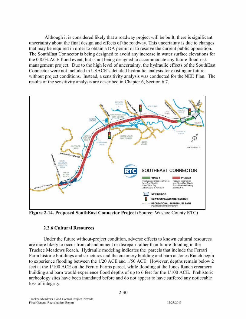
Washoe County Regional Transportation Commission (RTC) plans to construct a 5.5 mile north to south roadway in the USACE study area. This roadway is referred to as the SouthEast Connector and spans the Truckee River and smaller creeks in the study area. Construction is planned in two phases:
Phase 1 begins at the intersection of Greg Street and Sparks Boulevard in the city of Sparks and continues to just south of Clean Water Way, as shown in Figure 2-14. It includes bridges over the Truckee River and over Clean Water Way. Construction of Phase 1 has begun and is scheduled for completion in April 2014. Due to the design of the bridges, there would be no placement of dredged or fill material in waters of the United States and thus no Department of the Army (DA) permit from USACE under Section 404 of the Clean Water Act was required for Phase 1.
Phase 2 includes a roadway from Clean Water Way to the intersection of South Meadows Parkway and Veterans Parkway. Phase 2 has opposition from citizen groups, including a notice of intent to sue. This roadway does impact jurisdictional waters of the United States, so the RTC must obtain a Section 404 permit. A permit application was recently submitted to USACE. Construction is tentatively scheduled by RTC for 2014 to 2016.
Truckee Meadows Flood Control Project, NevadaFinal General Reevaluation Report 12/23/2013
2-30
Although it is considered likely that a roadway project will be built, there is significantuncertainty about the final design and effects of the roadway. This uncertainty is due to changes that may be required in order to obtain a DA permit or to resolve the current public opposition.The SouthEast Connector is being designed to avoid any increase in water surface elevations for the 0.85% ACE flood event, but is not being designed to accommodate any future flood risk management project. Due to the high level of uncertainty, the hydraulic effects of the SouthEast Connector were not included in USACE’s detailed hydraulic analysis for existing or future without project conditions. Instead, a sensitivity analysis was conducted for the NED Plan. The results of the sensitivity analysis are described in Chapter 6, Section 6.7.
Figure 2-14. Proposed SouthEast Connector Project (Source: Washoe County RTC)
2.2.6 Cultural Resources
Under the future without-project condition, adverse effects to known cultural resources are more likely to occur from abandonment or disrepair rather than future flooding in the Truckee Meadows Reach. Hydraulic modeling indicates the parcels that include the Ferrari Farm historic buildings and structures and the creamery building and barn at Jones Ranch begin to experience flooding between the 1/20 ACE and 1/50 ACE. However, depths remain below 2 feet at the 1/100 ACE on the Ferrari Farms parcel, while flooding at the Jones Ranch creamery building and barn would experience flood depths of up to 6 feet for the 1/100 ACE. Prehistoricarcheology sites have been inundated before and do not appear to have suffered any noticeableloss of integrity.
5-16
Truckee Meadows Flood Control Project, Nevada 12/23/2013Final General Reevaluation Report
features that could be added to the NED Plan by local interests to achieve NFIP compliance, without modifying the NED Plan. NFIP compliance costs have been identified pursuant to the joint FEMA-USACE memorandum, subject: FEMA/USACE Joint Actions on Planning for Flood Risk Management Projects, signed in June 2012.
USACE considered several options for NFIP compliance and determined that non-structural methods including house raising would likely be the least-cost option on the south side of the Truckee River. Through coordination with regional FEMA staff, it was verified that raising the first floors of affected residences above the new base flood elevation would comply with the NFIP regulation. Approximately 764 homes and 128 multiplex apartment buildings would need to be raised in the area south of the river. Additionally, four commercial structures and three public buildings would also need to be raised or “wet flood-proofed” with closures and sealing. Figure 5-7 identifies the land parcels with structures that are estimated to require raisingor flood-proofing. The preliminary cost estimate to raise and flood-proof structures for NFIP compliance on the south side of the Truckee River is $172 million. For the north side of the Truckee River, a 400-cfs capacity pump station on the North Truckee Drain with an outfall to the Truckee River would be the least-cost option. The estimated first cost for the pump station is $23 million. Therefore, the total estimated minimum non-Federal costs cost for NFIP compliance is $195 million.
Because compliance with the NFIP is a non-Federal responsibility, the affected NFIP communities could develop their own plan for compliance with the NFIP and would not be required to implement the specific assumed least-cost features. The estimated NFIP compliance costs are subject to change based on more detailed hydraulic analysis during final design of the project, including the results of NFIP hydraulic modeling assumptions and methods, and more detailed surveys of the elevations of existing structures.
5.8.5. Sensitivity Analysis of Potential Additional Effects of SouthEast Connector
Washoe County Regional Transportation Commission (RTC) plans to construct a 5.5 mile north to south roadway, SouthEast Connector, in the USACE study area (Figure 5-5).Although it is considered likely that a roadway project will be built, there is significant uncertainty about the final design and effects of the roadway. This uncertainty is due to changes that may be required in order to obtain a USACE permit and any changes resulting from the public opposition. However, a sensitivity analysis was conducted based on the current roadway design to determine whether it would significantly change the results of the economic analysis of the NED Plan or the recommendations in this GRR.
USACE reviewed the 50% design of the roadway and using professional hydraulic engineering judgment has estimated that the water surface elevation for the 1% ACE flood event under the NED Plan would increase up to an additional 1 foot (plus or minus 0.5 foot) primarily in the area on the west side of the roadway. An estimated 153 additional structures would have a 1% base flood elevation increased above their first floor. It is estimated that 152 of those
5-17
Truckee Meadows Flood Control Project, Nevada 12/23/2013Final General Reevaluation Report
structures would need to be elevated for NFIP compliance and one commercial structure would be floodproofed. The 899 structures identified in Section 5.8.4 would also need to be raised (orfloodproofed if appropriate) an additional foot. Based on preliminary estimates, the additional minimum non-Federal cost for NFIP compliance, if the SouthEast Connector is constructed as currently designed, would be $29 million, which is approximately $1.3 million in annual costs.A sensitivity analysis of the effect of that potential additional economic cost on the project justification is included in Section 6.7.
The hydraulic effects of the final design of the SouthEast Connector will be consideredduring PED for the Truckee Meadows Flood Control Project and adjustments will be made as appropriate.
5.9 Restoration of Fish Passage in the Truckee River
The Lahontan cutthroat trout (LCT) and cui-ui lake sucker occur only in the Truckee River and Pyramid Lake. The LCT is a Federally listed threatened species. The cui-ui is listed as endangered by both the Federal government and the State of Nevada. Both fish species are institutionally recognized as significant based on the criteria in ER 1105-2-100, Appendix E. The cui-ui is also publicly recognized as significant by the Pyramid Lake Paiute Tribe as a sacred resource. The LCT can be found throughout the entire Truckee River, although self-sustaining populations are only found in a few tributaries of the upper watershed. The cui-ui are not currently able to access the river above Derby Dam.
6-20Truckee Meadows Flood Control Project, Nevada 12/23/2013Final General Reevaluation Report
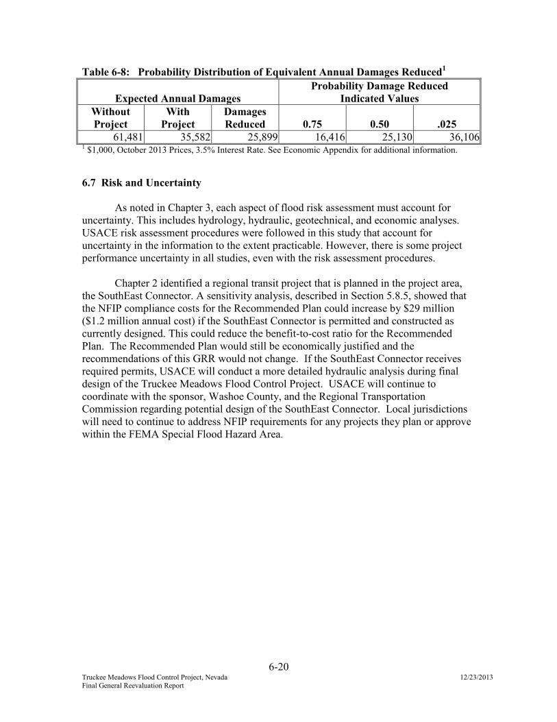
Table 6-8: Probability Distribution of Equivalent Annual Damages Reduced1
Expected Annual Damages
Probability Damage Reduced
Indicated Values
Without
Project
With
Project
Damages
Reduced 0.75 0.50 .025
61,481 35,582 25,899 16,416 25,130 36,1061 $1,000, October 2013 Prices, 3.5% Interest Rate. See Economic Appendix for additional information.
6.7 Risk and Uncertainty
As noted in Chapter 3, each aspect of flood risk assessment must account for uncertainty. This includes hydrology, hydraulic, geotechnical, and economic analyses.USACE risk assessment procedures were followed in this study that account for uncertainty in the information to the extent practicable. However, there is some project performance uncertainty in all studies, even with the risk assessment procedures.
Chapter 2 identified a regional transit project that is planned in the project area, the SouthEast Connector. A sensitivity analysis, described in Section 5.8.5, showed that the NFIP compliance costs for the Recommended Plan could increase by $29 million ($1.2 million annual cost) if the SouthEast Connector is permitted and constructed as currently designed. This could reduce the benefit-to-cost ratio for the Recommended Plan. The Recommended Plan would still be economically justified and the recommendations of this GRR would not change. If the SouthEast Connector receives required permits, USACE will conduct a more detailed hydraulic analysis during final design of the Truckee Meadows Flood Control Project. USACE will continue to coordinate with the sponsor, Washoe County, and the Regional Transportation Commission regarding potential design of the SouthEast Connector. Local jurisdictions will need to continue to address NFIP requirements for any projects they plan or approvewithin the FEMA Special Flood Hazard Area.