Trek Mount Kilimanjaro via Lemosho Route | Private Expeditions
2
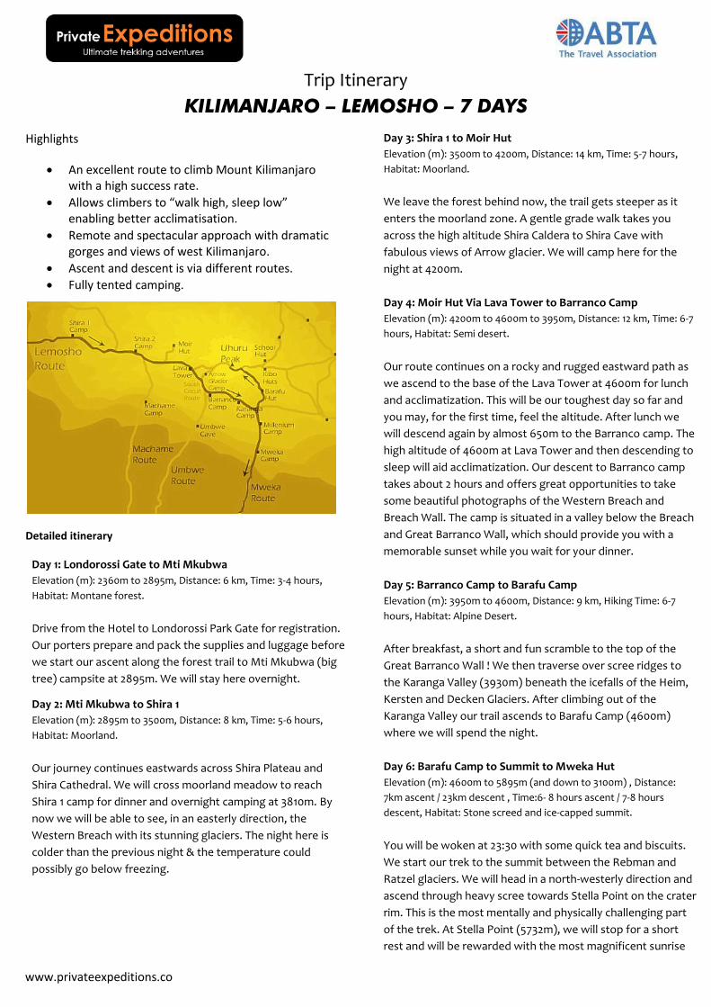
Trip Itinerary KILIMANJARO – LEMOSHO – 7 DAYS Highlights An excellent route to climb Mount Kilimanjaro with a high success rate. Allows climbers to “walk high, sleep low” enabling better acclimatisation. Remote and spectacular approach with dramatic gorges and views of west Kilimanjaro. Ascent and descent is via different routes. Fully tented camping. Detailed itinerary Day 1: Londorossi Gate to Mti Mkubwa Elevation (m): 2360m to 2895m, Distance: 6 km, Time: 3-4 hours, Habitat: Montane forest. Drive from the Hotel to Londorossi Park Gate for registration. Our porters prepare and pack the supplies and luggage before we start our ascent along the forest trail to Mti Mkubwa (big tree) campsite at 2895m. We will stay here overnight. Day 2: Mti Mkubwa to Shira 1 Elevation (m): 2895m to 3500m, Distance: 8 km, Time: 5-6 hours, Habitat: Moorland. Our journey continues eastwards across Shira Plateau and Shira Cathedral. We will cross moorland meadow to reach Shira 1 camp for dinner and overnight camping at 3810m. By now we will be able to see, in an easterly direction, the Western Breach with its stunning glaciers. The night here is colder than the previous night & the temperature could possibly go below freezing. Day 3: Shira 1 to Moir Hut Elevation (m): 3500m to 4200m, Distance: 14 km, Time: 5-7 hours, Habitat: Moorland. We leave the forest behind now, the trail gets steeper as it enters the moorland zone. A gentle grade walk takes you across the high altitude Shira Caldera to Shira Cave with fabulous views of Arrow glacier. We will camp here for the night at 4200m. Day 4: Moir Hut Via Lava Tower to Barranco Camp Elevation (m): 4200m to 4600m to 3950m, Distance: 12 km, Time: 6-7 hours, Habitat: Semi desert. Our route continues on a rocky and rugged eastward path as we ascend to the base of the Lava Tower at 4600m for lunch and acclimatization. This will be our toughest day so far and you may, for the first time, feel the altitude. After lunch we will descend again by almost 650m to the Barranco camp. The high altitude of 4600m at Lava Tower and then descending to sleep will aid acclimatization. Our descent to Barranco camp takes about 2 hours and offers great opportunities to take some beautiful photographs of the Western Breach and Breach Wall. The camp is situated in a valley below the Breach and Great Barranco Wall, which should provide you with a memorable sunset while you wait for your dinner. Day 5: Barranco Camp to Barafu Camp Elevation (m): 3950m to 4600m, Distance: 9 km, Hiking Time: 6-7 hours, Habitat: Alpine Desert. After breakfast, a short and fun scramble to the top of the Great Barranco Wall ! We then traverse over scree ridges to the Karanga Valley (3930m) beneath the icefalls of the Heim, Kersten and Decken Glaciers. After climbing out of the Karanga Valley our trail ascends to Barafu Camp (4600m) where we will spend the night. Day 6: Barafu Camp to Summit to Mweka Hut Elevation (m): 4600m to 5895m (and down to 3100m) , Distance: 7km ascent / 23km descent , Time:6- 8 hours ascent / 7-8 hours descent, Habitat: Stone screed and ice-capped summit. You will be woken at 23:30 with some quick tea and biscuits. We start our trek to the summit between the Rebman and Ratzel glaciers. We will head in a north-westerly direction and ascend through heavy scree towards Stella Point on the crater rim. This is the most mentally and physically challenging part of the trek. At Stella Point (5732m), we will stop for a short rest and will be rewarded with the most magnificent sunrise www.privateexpeditions.co
-
Upload
privateexpeditions -
Category
Travel
-
view
42 -
download
1
Transcript of Trek Mount Kilimanjaro via Lemosho Route | Private Expeditions
Trip Itinerary
KILIMANJARO – LEMOSHO – 7 DAYS
Highlights
An excellent route to climb Mount Kilimanjaro with a high success rate.
Allows climbers to “walk high, sleep low” enabling better acclimatisation.
Remote and spectacular approach with dramatic gorges and views of west Kilimanjaro.
Ascent and descent is via different routes.
Fully tented camping.
Detailed itinerary
Day 1: Londorossi Gate to Mti Mkubwa
Elevation (m): 2360m to 2895m, Distance: 6 km, Time: 3-4 hours,
Habitat: Montane forest.
Drive from the Hotel to Londorossi Park Gate for registration.
Our porters prepare and pack the supplies and luggage before
we start our ascent along the forest trail to Mti Mkubwa (big
tree) campsite at 2895m. We will stay here overnight.
Day 2: Mti Mkubwa to Shira 1
Elevation (m): 2895m to 3500m, Distance: 8 km, Time: 5-6 hours,
Habitat: Moorland.
Our journey continues eastwards across Shira Plateau and
Shira Cathedral. We will cross moorland meadow to reach
Shira 1 camp for dinner and overnight camping at 3810m. By
now we will be able to see, in an easterly direction, the
Western Breach with its stunning glaciers. The night here is
colder than the previous night & the temperature could
possibly go below freezing.
Day 3: Shira 1 to Moir Hut
Elevation (m): 3500m to 4200m, Distance: 14 km, Time: 5-7 hours,
Habitat: Moorland.
We leave the forest behind now, the trail gets steeper as it
enters the moorland zone. A gentle grade walk takes you
across the high altitude Shira Caldera to Shira Cave with
fabulous views of Arrow glacier. We will camp here for the
night at 4200m.
Day 4: Moir Hut Via Lava Tower to Barranco Camp
Elevation (m): 4200m to 4600m to 3950m, Distance: 12 km, Time: 6-7
hours, Habitat: Semi desert.
Our route continues on a rocky and rugged eastward path as
we ascend to the base of the Lava Tower at 4600m for lunch
and acclimatization. This will be our toughest day so far and
you may, for the first time, feel the altitude. After lunch we
will descend again by almost 650m to the Barranco camp. The
high altitude of 4600m at Lava Tower and then descending to
sleep will aid acclimatization. Our descent to Barranco camp
takes about 2 hours and offers great opportunities to take
some beautiful photographs of the Western Breach and
Breach Wall. The camp is situated in a valley below the Breach
and Great Barranco Wall, which should provide you with a
memorable sunset while you wait for your dinner.
Day 5: Barranco Camp to Barafu Camp
Elevation (m): 3950m to 4600m, Distance: 9 km, Hiking Time: 6-7
hours, Habitat: Alpine Desert.
After breakfast, a short and fun scramble to the top of the
Great Barranco Wall ! We then traverse over scree ridges to
the Karanga Valley (3930m) beneath the icefalls of the Heim,
Kersten and Decken Glaciers. After climbing out of the
Karanga Valley our trail ascends to Barafu Camp (4600m)
where we will spend the night.
Day 6: Barafu Camp to Summit to Mweka Hut
Elevation (m): 4600m to 5895m (and down to 3100m) , Distance:
7km ascent / 23km descent , Time:6- 8 hours ascent / 7-8 hours
descent, Habitat: Stone screed and ice-capped summit.
You will be woken at 23:30 with some quick tea and biscuits.
We start our trek to the summit between the Rebman and
Ratzel glaciers. We will head in a north-westerly direction and
ascend through heavy scree towards Stella Point on the crater
rim. This is the most mentally and physically challenging part
of the trek. At Stella Point (5732m), we will stop for a short
rest and will be rewarded with the most magnificent sunrise
www.privateexpeditions.co

Trip Itinerary
KILIMANJARO – LEMOSHO – 7 DAYS
you are ever likely to see (weather permitting). At Uhuru Peak
(5895m), we will have reached the highest point on Mount
Kilimanjaro and the continent of Africa. It can be very cold at
night at these elevations, but it will be quite warm by the end
of the hiking day. From the summit, we descend down to the
Mweka Hut camp site, via Barafu for lunch. Trekking poles will
be needed for the loose gravel going down to Mweka Camp
(3100m). Later in the evening, we will enjoy our last dinner on
the mountain and a well-earned sleep.
Day 7: Mweka Camp to Mweka Gate
Elevation (m): 3100m to 1800m, Distance: 10 km, Hiking Time: 3-4
hours, Habitat: Forest.
We depart after breakfast descending down to the Mweka
Park Gate to receive your summit certificates. At lower
elevations, it can be wet and muddy. Gaiters and trekking
poles will help. Shorts and t-shirts will be suitable (keep rain
gear and warmer clothing handy).
Topography
The Lemosho route starts from Londorossi Gate and the first two days are spent trekking through rainforest, where you may see wild game. It then traverses up to Shira Ridge, Kilimanjaro’s third summit. From here you will ascend and cross the expansive Shira Plateau with fantastic views of Shira Cathedral. On the Shira route you will take a vehicle directly up to the Shira Gate to commence your trek up to Shira Camp where you will spend your first night at 3600m. The high altitude start on the Shira route is not recommended for good acclimatisation as climbers may experience symptoms of altitude on their first day. After day 1 the Lemosho and Shira routes merge. The descent is along the Mweka Route, a descent-only route. The minimum time taken for the Lemosho route is 7 days, but again an extra day to acclimatise is recommended to improve the chances of summiting.
0
1000
2000
3000
4000
5000
6000
7000
Star
t
Mti
Ku
bw
a
Shir
a 1
Mo
ir H
ut
Lava
to
wer
Bar
anco
Bar
afu
Sum
mit
Mw
eka
Hu
t
Fin
ish
Lemosho 7 Day Climb Height in Metres
Summary Both the Lemosho and Shira routes approach Kilimanjaro from the west and cross the Shira Plateau. Lemosho is a relatively new route and is an improvement on the original Shira route as it starts much lower than Shira thus improving acclimatisation. The Lemosho route is one of our highly recommended routes, not only for its beautiful scenery but also its’ high summit success due to the longer and steadier walk in improving acclimatisation. The first two days of the route have low traffic and are quite unspoilt, however, thereafter it joins with the Machame route to the summit.
www.privateexpeditions.co
Minshi
Typewritten text
Visit Private Expeditions for More Information