Town of LaGrange
1
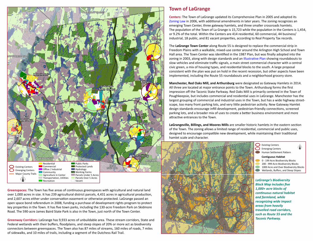
PLEASANT VALLEY C D 376 C D 82 C D 55 4 5 6 7 21 4 5 6 7 42 4 5 6 7 10 4 5 6 7 46 4 5 6 7 33 4 5 6 7 49 4 5 6 7 44 4 5 6 7 43 4 5 6 7 89 4 5 6 7 47 C E TSP Red Oaks Mill Arthursburg LaGrange Town Center Billings Moores Mills Lagrangeville Manchester POUGHKEEPSIE BEEKMAN UNION VALE WAPPINGER EAST FISHKILL Town of LaGrange Centers: The Town of LaGrange updated its Comprehensive Plan in 2005 and adopted its Zoning Law in 2006, with addional amendments in later years. The zoning recognizes an emerging Town Center, three gateway hamlets, and three smaller crossroads hamlets. The populaon of the Town of La Grange is 15,723 while the populaon in the Centers is 1,454, or 9.2% of the total. Within the Centers are 414 residenal, 60 commercial, 44 business/ industrial, 18 public, and 81 vacant properes, according to Real Property Tax records. The LaGrange Town Center along Route 55 is designed to replace the commercial strip in Freedom Plains with a walkable, mixed-use center around the Arlington High School and Town Hall area. The Town Center was idenfied in the 1987 Plan, but was finally adopted into the zoning in 2003, along with design standards and an Illustrave Plan showing roundabouts to slow vehicles and eliminate traffic signals, a main street commercial character with a central civic green, a mix of housing types, and residenal blocks to the south. A large proposal consistent with the plan was put on hold in the recent recession, but other aspects have been implemented, including the Route 55 roundabouts and a neighborhood grocery store. Manchester, Red Oaks Mill, and Arthursburg were designated as Gateway Hamlets in 2014. All three are located at major entrance points to the Town. Arthursburg forms the first impression off the Taconic State Parkway. Red Oaks Mill is primarily centered in the Town of Poughkeepsie, but includes commercial and residenal uses in LaGrange. Manchester has the largest grouping of commercial and industrial uses in the Town, but has a wide highway street- scape, too many front parking lots, and very lile pedestrian acvity. New Gateway Hamlet design standards encourage infill development, pedestrian-friendly connecons, screened parking lots, and a broader mix of uses to create a beer business environment and more aracve entrances to the Town. LaGrangeville, Billings, and Moores Mills are smaller historic hamlets in the eastern secon of the Town. The zoning allows a limited range of residenal, commercial and public uses, designed to encourage compable new development, while maintaining their tradional hamlet scale and character. LaGrange’s Biodiversity Block Map includes five 1,000+ acre blocks of connuous natural habitat and farmland, while recognizing wide impact areas from heavily travelled road corridors, such as Route 55 and the Taconic Parkway. Greenspaces: The Town has five areas of connuous greenspaces with agricultural and natural land over 1,000 acres in size. It has 239 agricultural district parcels, 4,431 acres in agricultural producon, and 2,607 acres either under conservaon easement or otherwise protected. LaGrange passed an open space bond referendum in 2008, funding a purchase of development rights program to protect key properes in the Town. It has five town parks, including the 130-acre Freedom Park on Skidmore Road. The 590-acre James Baird State Park is also in the Town, just north of the Town Center. Greenway Corridors: LaGrange has 9,933 acres of unbuildable area. These stream corridors, State and Federal wetlands with their buffers, floodplains, and steep slopes of 20% or more act as biodiversity connectors between greenspaces. The Town also has 87 miles of streams, 160 miles of roads, 7 miles of sidewalks, and 10 miles of trails, including a segment of the Dutchess Rail Trail. Existing Centers Emerging Centers Human Settlement Pattern Contiguous Habitat 1000 Acre and Over Biodiversity Blocks 200 - 999 Acre Biodiversity Blocks 0 - 199 Acre Biodiversity Blocks Wetlands, Buffers, and Steep Slopes o Major County Trails Emerging Centers Existing Centers Hydrology Protected Lands Parcels Over 5 Acres Parcels Under 5 Acres Working Farms Vacant Public Parks Residential Commercial Transportation, Utilities Community Office / Industrial Agriculture in Center Recreation o
Transcript of Town of LaGrange
PLEASANT VALLEY
CD376
CD82CD55
456721
456742
456710
456746
456733
456749
456744
456743
456789
456747
CETSP
RedOaks Mill
Arthursburg
LaGrangeTown Center
Billings
MooresMills
Lagrangeville
Manchester
POUGHKEEPSIE
BEEKMAN
UN
ION
VA
LE
WAPPINGER
EASTFISHKILL
Town of LaGrangeCenters: The Town of LaGrange updated its Comprehensive Plan in 2005 and adopted itsZoning Law in 2006, with additional amendments in later years. The zoning recognizes an emerging Town Center, three gateway hamlets, and three smaller crossroads hamlets.The population of the Town of La Grange is 15,723 while the population in the Centers is 1,454,or 9.2% of the total. Within the Centers are 414 residential, 60 commercial, 44 business/industrial, 18 public, and 81 vacant properties, according to Real Property Tax records.
The LaGrange Town Center along Route 55 is designed to replace the commercial strip inFreedom Plains with a walkable, mixed-use center around the Arlington High School and Town Hall area. The Town Center was identified in the 1987 Plan, but was finally adopted into thezoning in 2003, along with design standards and an Illustrative Plan showing roundabouts to slow vehicles and eliminate traffic signals, a main street commercial character with a centralcivic green, a mix of housing types, and residential blocks to the south. A large proposalconsistent with the plan was put on hold in the recent recession, but other aspects have been implemented, including the Route 55 roundabouts and a neighborhood grocery store.
Manchester, Red Oaks Mill, and Arthursburg were designated as Gateway Hamlets in 2014.All three are located at major entrance points to the Town. Arthursburg forms the firstimpression off the Taconic State Parkway. Red Oaks Mill is primarily centered in the Town of Poughkeepsie, but includes commercial and residential uses in LaGrange. Manchester has the largest grouping of commercial and industrial uses in the Town, but has a wide highway street-scape, too many front parking lots, and very little pedestrian activity. New Gateway Hamlet design standards encourage infill development, pedestrian-friendly connections, screenedparking lots, and a broader mix of uses to create a better business environment and more attractive entrances to the Town.
LaGrangeville, Billings, and Moores Mills are smaller historic hamlets in the eastern sectionof the Town. The zoning allows a limited range of residential, commercial and public uses,designed to encourage compatible new development, while maintaining their traditionalhamlet scale and character.
LaGrange’s Biodiversity Block Map includes five 1,000+ acre blocks ofcontinuous natural habitat and farmland, whilerecognizing wide impactareas from heavilytravelled road corridors, such as Route 55 and the Taconic Parkway.
Greenspaces: The Town has five areas of continuous greenspaces with agricultural and natural landover 1,000 acres in size. It has 239 agricultural district parcels, 4,431 acres in agricultural production,and 2,607 acres either under conservation easement or otherwise protected. LaGrange passed anopen space bond referendum in 2008, funding a purchase of development rights program to protectkey properties in the Town. It has five town parks, including the 130-acre Freedom Park on SkidmoreRoad. The 590-acre James Baird State Park is also in the Town, just north of the Town Center.
Greenway Corridors: LaGrange has 9,933 acres of unbuildable area. These stream corridors, State and Federal wetlands with their buffers, floodplains, and steep slopes of 20% or more act as biodiversityconnectors between greenspaces. The Town also has 87 miles of streams, 160 miles of roads, 7 milesof sidewalks, and 10 miles of trails, including a segment of the Dutchess Rail Trail.
Existing CentersEmerging CentersHuman Settlement Pattern
Contiguous Habitat
1000 Acre and Over Biodiversity Blocks200 - 999 Acre Biodiversity Blocks0 - 199 Acre Biodiversity Blocks
Wetlands, Buffers, and Steep Slopes
o
Major County T r a i l sEmerging CentersExisting Centers
HydrologyProtected Lands
Parcels Over 5 AcresParcels Under 5 AcresWorking Farms
Vacant
Public ParksResidentialCommercial
Transportation, Utilities
CommunityOffice / Industrial
Agriculture in Center
Recreationo