
SQL Geography Datatypes by Jared Nielsen and the FUZION Agency
40
GEOGRAPHY DATATYPES in SQL Server by jared nielsen linkedin.com/nielsendata
-
Upload
jared-nielsen -
Category
Data & Analytics
-
view
188 -
download
0
Transcript of SQL Geography Datatypes by Jared Nielsen and the FUZION Agency

GEOGRAPHY DATATYPESin SQL Server
by jared nielsenlinkedin.com/nielsendata
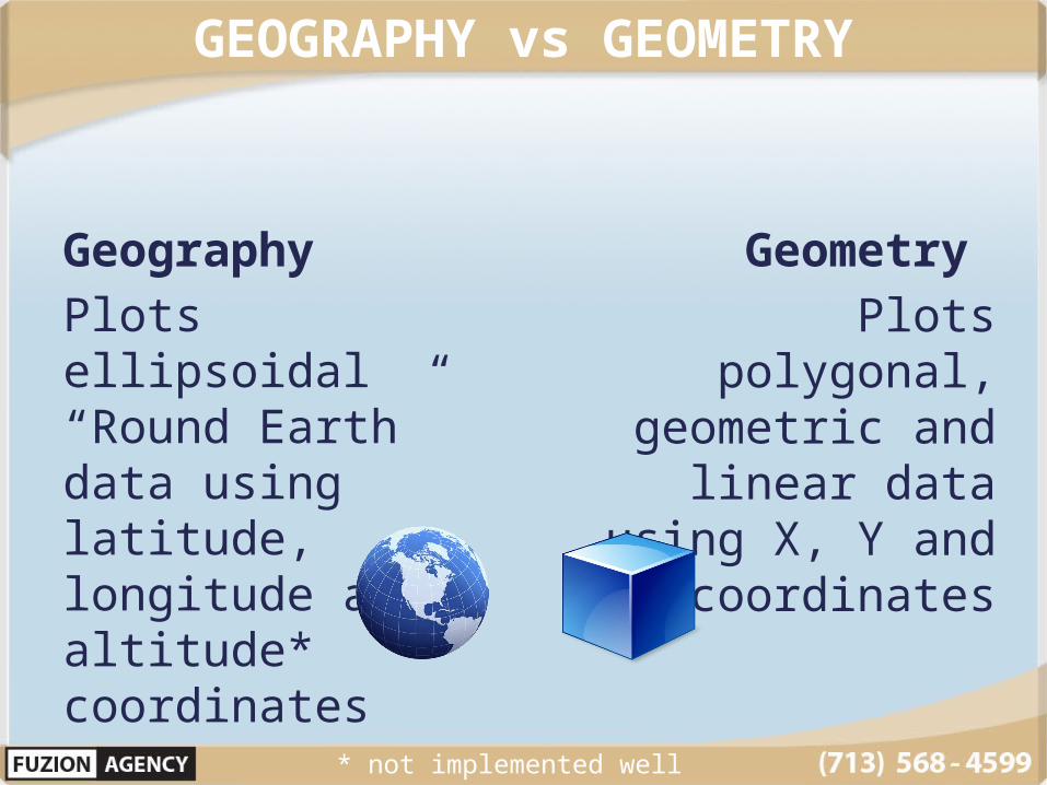
GEOGRAPHY vs GEOMETRY
Geography Plots ellipsoidal “Round Earth” data using latitude, longitude and altitude* coordinates
Geometry Plots polygonal,
geometric and linear data using
X, Y and Z* coordinates
* not implemented well

Measuring the Earth
CoordinatesLongitude = XLatitude = YAltitude = Z

Measuring the Earth
RangesLongitude = 0 to 360°Latitude = 90° to -90°Altitude = 0 to ∞ (ft)
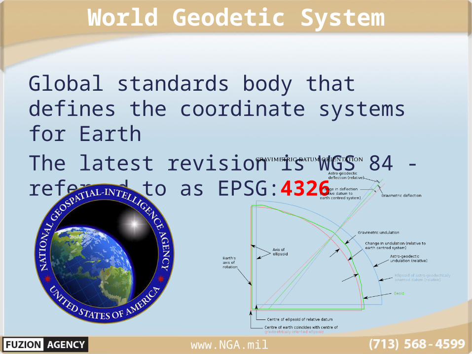
World Geodetic System
Global standards body that defines the coordinate systems for EarthThe latest revision is WGS 84 - referred to as EPSG:4326
www.NGA.mil
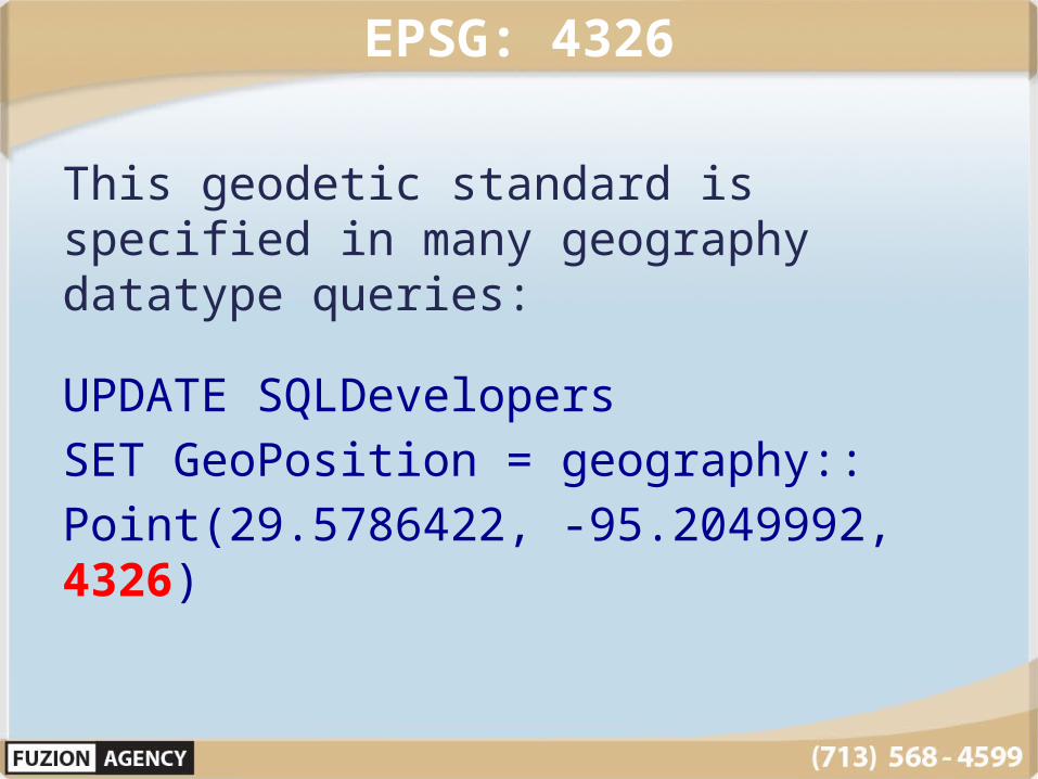
EPSG: 4326
This geodetic standard is specified in many geography datatype queries:
UPDATE SQLDevelopersSET GeoPosition = geography::Point(29.5786422, -95.2049992, 4326)
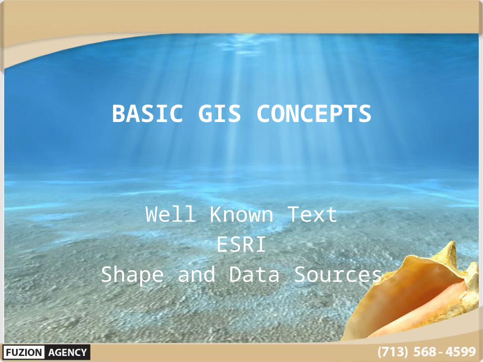
BASIC GIS CONCEPTS
Well Known TextESRI
Shape and Data Sources

Well Known Text - WKT
www.NGA.mil
Type Example Convert to Spatial
Point Point(x,y) .STPointFromText()
MultiPoint MultiPoint( (x,y), (x,y) ) .STMPointFromText()
LineString LineString( x y, x y, x y) .STLineFromText()
MultiLineString
MultiLineString( (x y, x y) (x y, x y) )
.STMLineFromText()
Polygon Polygon ( (x1 y1, x2 y2, x3 y3, x1 y1) )
.STPolyFromText()
MultiPolygon You get the idea… Keep using those parenthesis…
.STMPolyFromText()

How LONG is your LAT?
Sometimes you should use LON/LAT (WKT)Other times you need to use LAT/LON (SQL)
LAT LONSan Jacinto College = 29.578, -95.204
SET GeoPosition = geography::STGeomFromText('POINT(-95.204 29.578)', 4326)
SET GeoPosition = geography::Point(29.578, -95.204 , 4326)
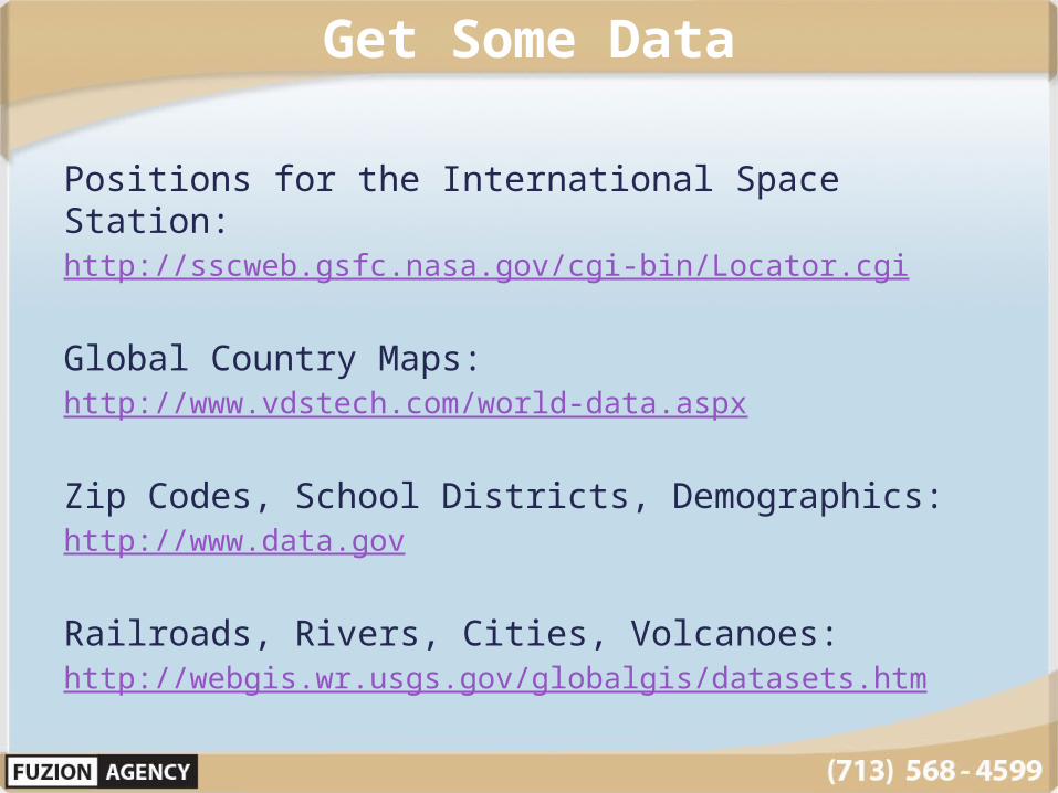
Get Some Data
Positions for the International Space Station:http://sscweb.gsfc.nasa.gov/cgi-bin/Locator.cgi
Global Country Maps:http://www.vdstech.com/world-data.aspx
Zip Codes, School Districts, Demographics:http://www.data.gov
Railroads, Rivers, Cities, Volcanoes:http://webgis.wr.usgs.gov/globalgis/datasets.htm

ESRI Shapefile Converters
Convert ESRI Shapefiles to SQL Geography:http://www.sharpgis.net/page/Shape2SQL
Queries SQL Geography to a Map:http://www.sharpgis.net/page/SqlSpatial-Query-Tool
ESRI Metadata Translation:http://resources.esri.com/help/9.3/ArcGISEngine/java/gp_toolref/conversion_tools/esri_metadata_translator_conversion_.htm
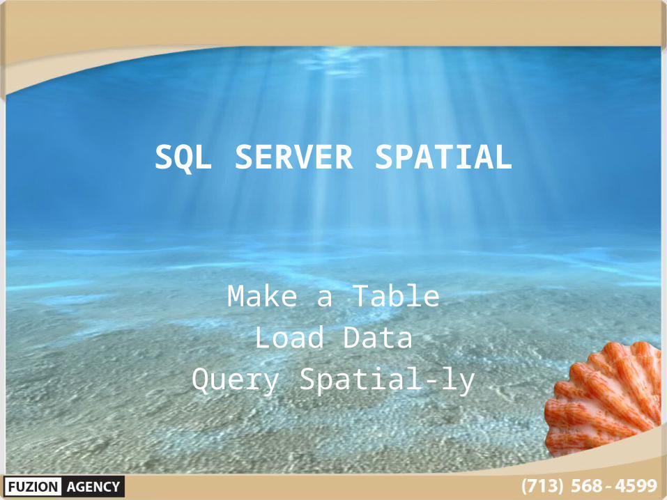
SQL SERVER SPATIAL
Make a TableLoad Data
Query Spatial-ly

Making a Table
CREATE TABLE dbo.ISSPosition(Longitude decimal(18, 15) NULL,Latitude decimal(18, 15) NULL,Sampled datetime NULL,LocalTime nvarchar(50) NULL,GeoPosition geography NULL,GeomShape geometry NULL
)

Loading Data
INSERT INTO ISSPosition (Sampled, Longitude, Latitude, LocalTime) VALUES ('01/01/2015 00:00:00',-125.4,41,'15:38:18’)
Naturally I loaded more data … one data point per minute from January 1 to present It turns out that the Space Station falls fast at
17,136 mph
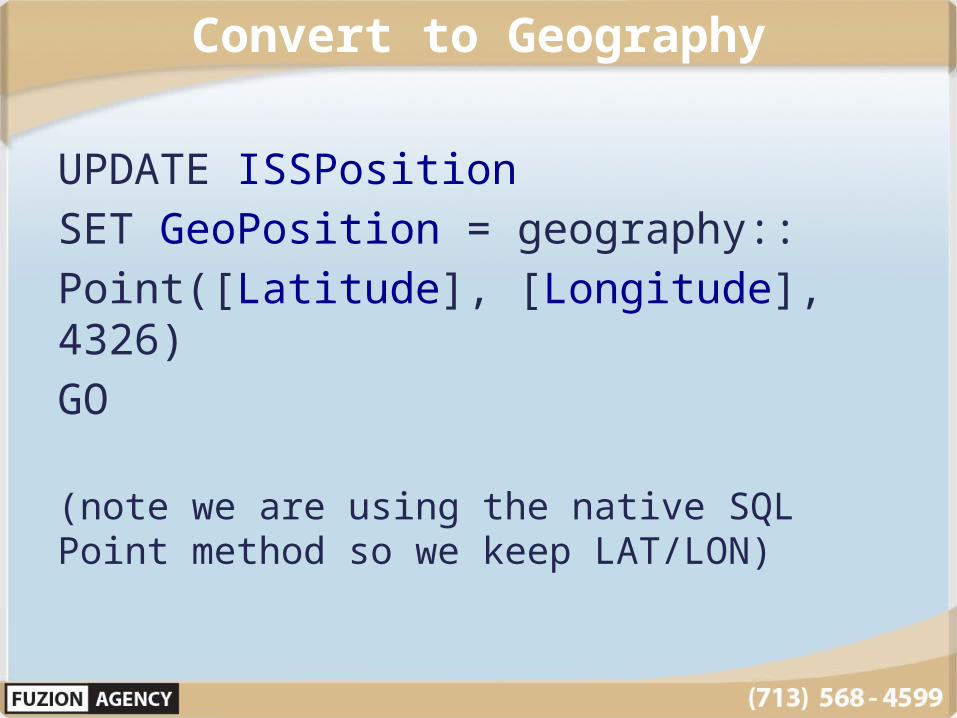
Convert to Geography
UPDATE ISSPositionSET GeoPosition = geography::Point([Latitude], [Longitude], 4326)GO
(note we are using the native SQL Point method so we keep LAT/LON)
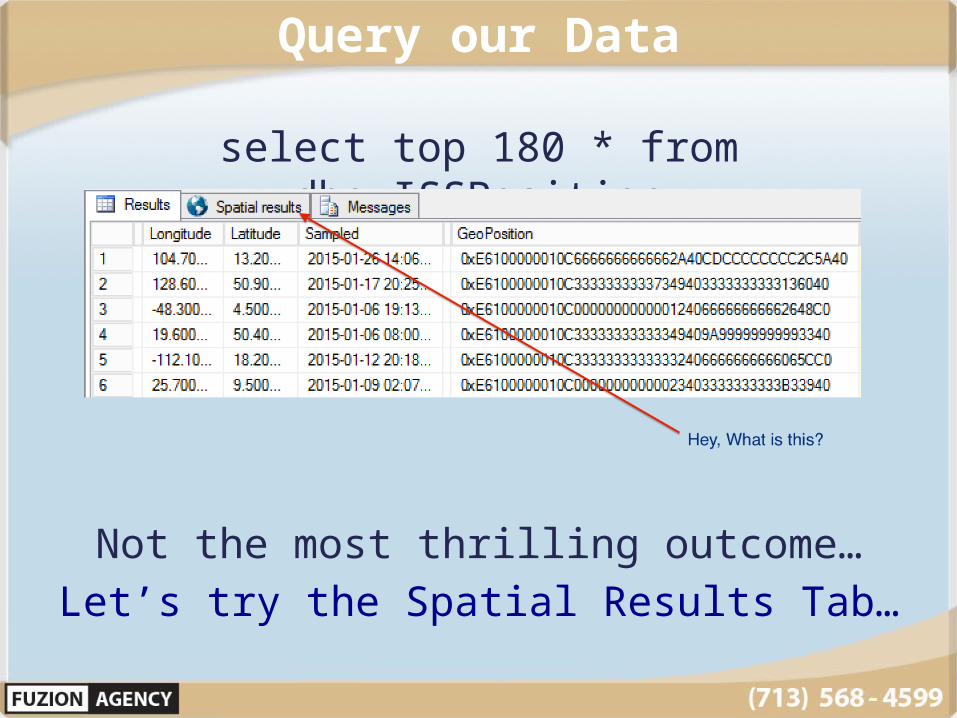
Query our Data
select top 180 * from dbo.ISSPosition
Not the most thrilling outcome…Let’s try the Spatial Results Tab…
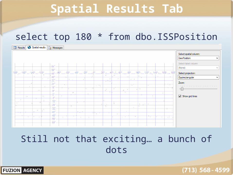
Spatial Results Tab
select top 180 * from dbo.ISSPosition
Still not that exciting… a bunch of dots
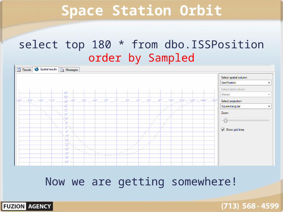
Space Station Orbit
select top 180 * from dbo.ISSPosition order by Sampled
Now we are getting somewhere!
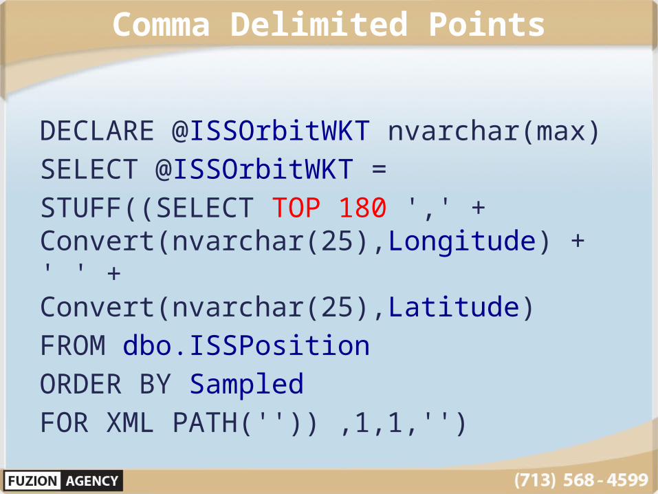
Comma Delimited Points
DECLARE @ISSOrbitWKT nvarchar(max)SELECT @ISSOrbitWKT = STUFF((SELECT TOP 180 ',' + Convert(nvarchar(25),Longitude) + ' ' + Convert(nvarchar(25),Latitude) FROM dbo.ISSPosition ORDER BY Sampled FOR XML PATH('')) ,1,1,'')
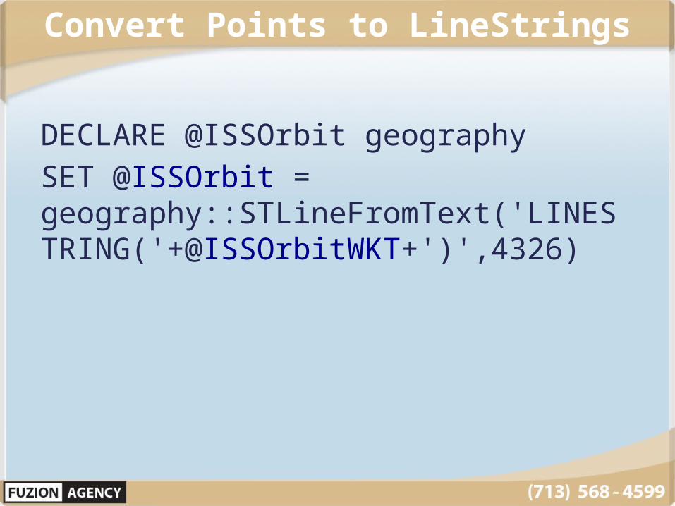
Convert Points to LineStrings
DECLARE @ISSOrbit geographySET @ISSOrbit = geography::STLineFromText('LINESTRING('+@ISSOrbitWKT+')',4326)

Space Station Orbit
SELECT @ISSOrbit
Now you have connected points in a linestring showing the orbit…

Space Station Orbit
CREATE TABLE CoolShapes(Name Nvarchar(100) NOT NULL, GeoShape geography NULL)
GOINSERT into CoolShapes (Name, GeoShape) values (‘ISS Orbital
Path’,@ISSOrbit)
I like this shape so much I’m going to keep a copy of it

World Geography
Global DatasetsFrom ESRI Shapefiles

Load Global Maps
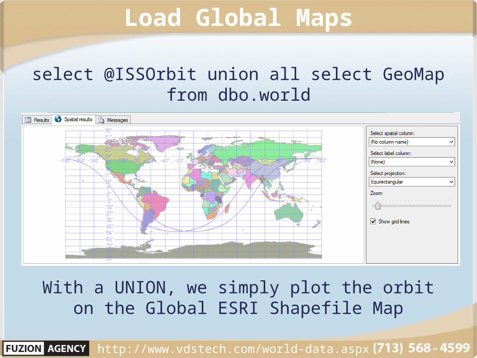
Load Global Maps
select @ISSOrbit union all select GeoMap from dbo.world
With a UNION, we simply plot the orbit on the Global ESRI Shapefile Map
http://www.vdstech.com/world-data.aspx

GEOGRAPHY Case Studies
INTERSECTIONBUFFERS
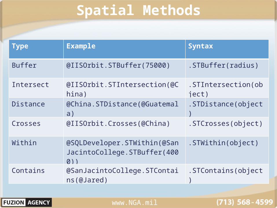
Spatial Methods
www.NGA.mil
Type Example Syntax
Buffer @IISOrbit.STBuffer(75000) .STBuffer(radius)
Intersect @IISOrbit.STIntersection(@China)
.STIntersection(object)
Distance @China.STDistance(@Guatemala)
.STDistance(object)
Crosses @IISOrbit.Crosses(@China) .STCrosses(object)
Within @SQLDeveloper.STWithin(@SanJacintoCollege.STBuffer(4000))
.STWithin(object)
Contains @SanJacintoCollege.STContains(@Jared)
.STContains(object)
STIntersection Method
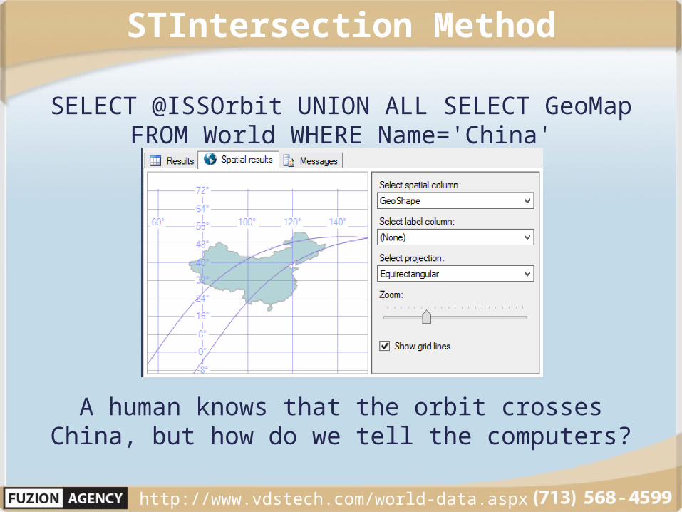
SELECT @ISSOrbit UNION ALL SELECT GeoMap FROM World WHERE Name='China'
A human knows that the orbit crosses China, but how do we tell the computers?
http://www.vdstech.com/world-data.aspx
STIntersection Method
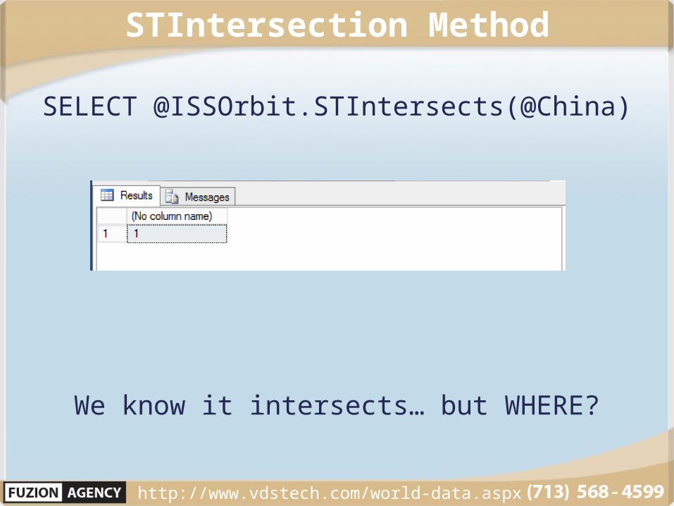
SELECT @ISSOrbit.STIntersects(@China)
We know it intersects… but WHERE?
http://www.vdstech.com/world-data.aspx

STIntersection Method
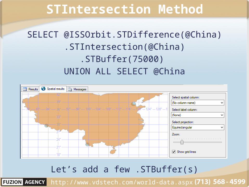
SELECT @ISSOrbit.STDifference(@China).STIntersection(@China)
Can you see them?
http://www.vdstech.com/world-data.aspx
STIntersection Method
SELECT @ISSOrbit.STDifference(@China).STIntersection(@China)
.STBuffer(75000) UNION ALL SELECT @China
Let’s add a few .STBuffer(s) http://www.vdstech.com/world-data.aspx

Can Your Sales Rep See the Customer at a Trade Show?
San Jacinto College
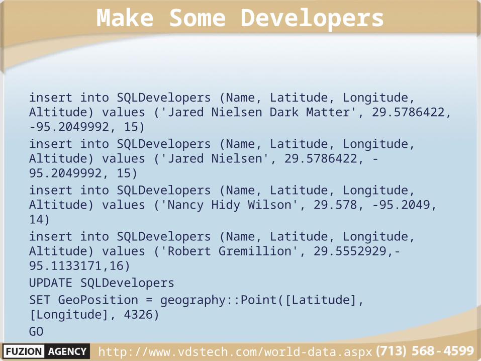
Make Some Developers
insert into SQLDevelopers (Name, Latitude, Longitude, Altitude) values ('Jared Nielsen Dark Matter', 29.5786422, -95.2049992, 15)insert into SQLDevelopers (Name, Latitude, Longitude, Altitude) values ('Jared Nielsen', 29.5786422, -95.2049992, 15)insert into SQLDevelopers (Name, Latitude, Longitude, Altitude) values ('Nancy Hidy Wilson', 29.578, -95.2049, 14)insert into SQLDevelopers (Name, Latitude, Longitude, Altitude) values ('Robert Gremillion', 29.5552929,-95.1133171,16)UPDATE SQLDevelopersSET GeoPosition = geography::Point([Latitude], [Longitude], 4326)GO
http://www.vdstech.com/world-data.aspx
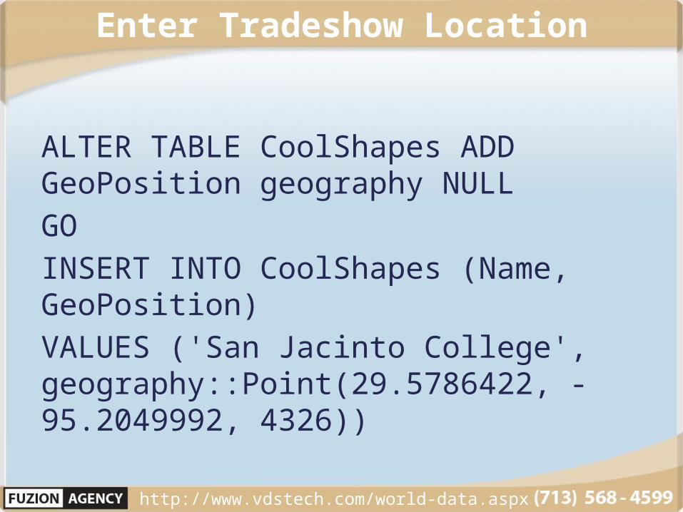
Enter Tradeshow Location
ALTER TABLE CoolShapes ADD GeoPosition geography NULLGOINSERT INTO CoolShapes (Name, GeoPosition) VALUES ('San Jacinto College', geography::Point(29.5786422, -95.2049992, 4326))
http://www.vdstech.com/world-data.aspx

STIntersection Method
One Developer is Not Attending http://www.vdstech.com/world-data.aspx
SELECT GeoPosition.STBuffer(100) FROM CoolShapes WHERE Name='San Jacinto College'UNION ALLSELECT GeoPosition.STBuffer(30) FROM SQLDevelopers

STIntersection Method
Who else is here? http://www.vdstech.com/world-data.aspx
SELECT GeoPosition.STBuffer(100) FROM CoolShapes WHERE Name='San Jacinto College'UNION ALLSELECT GeoPosition.STBuffer(30) FROM SQLDevelopers WHERE NAME NOT IN ('Robert Gremillion')

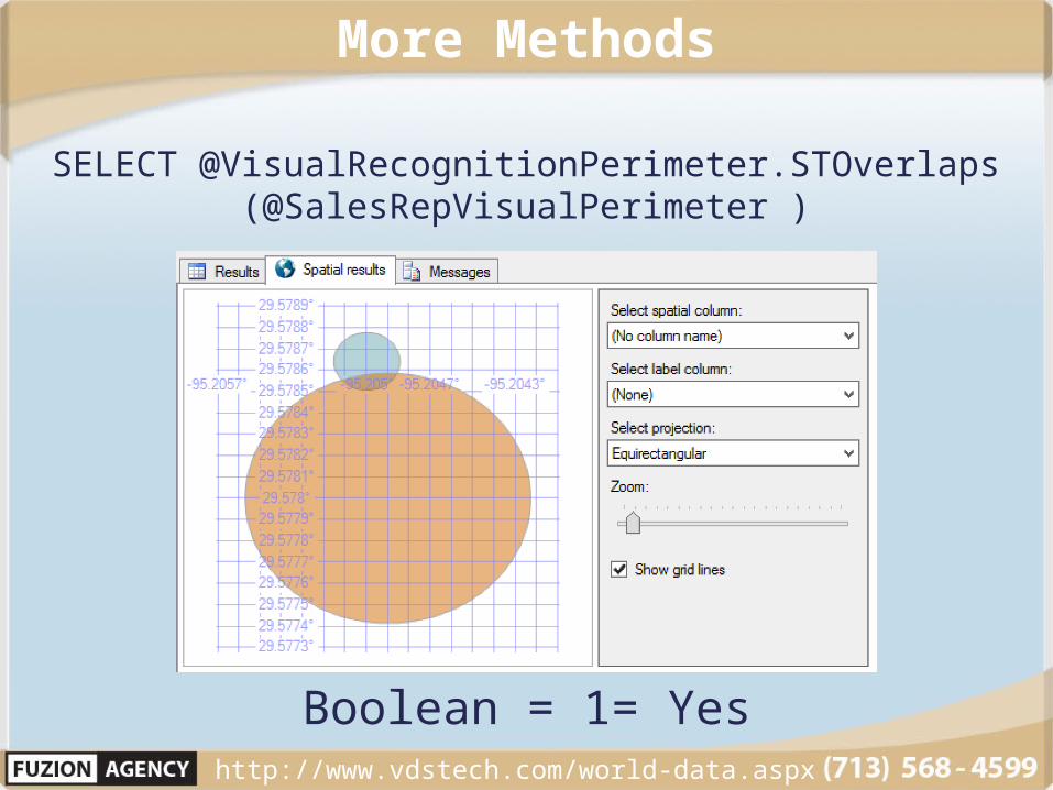
More Methods
http://www.vdstech.com/world-data.aspx
DECLARE @Jared geographyDECLARE @Robert geographyDECLARE @Nancy geographyDECLARE @SanJAC GeographyDECLARE @JaredGhost geography
SELECT @Jared = GeoPosition.STBuffer(5) FROM SQLDevelopers WHERE Name = 'Jared Nielsen'SELECT @Robert = Geoposition.STBuffer(5) from SQLDevelopers WHERE Name='Robert Gremillion'SELECT @Nancy = Geoposition.STBuffer(5) from SQLDevelopers wHERE Name LIKE 'Nancy%'SELECT @SanJAC = Geoposition.STBuffer(100) from CoolShapes WHERE Name = 'San Jacinto College'SELECT @JaredGhost = Geoposition.STBuffer(2) from SQLDevelopers WHERE Name = 'Jared Nielsen Dark Matter’
More Methods
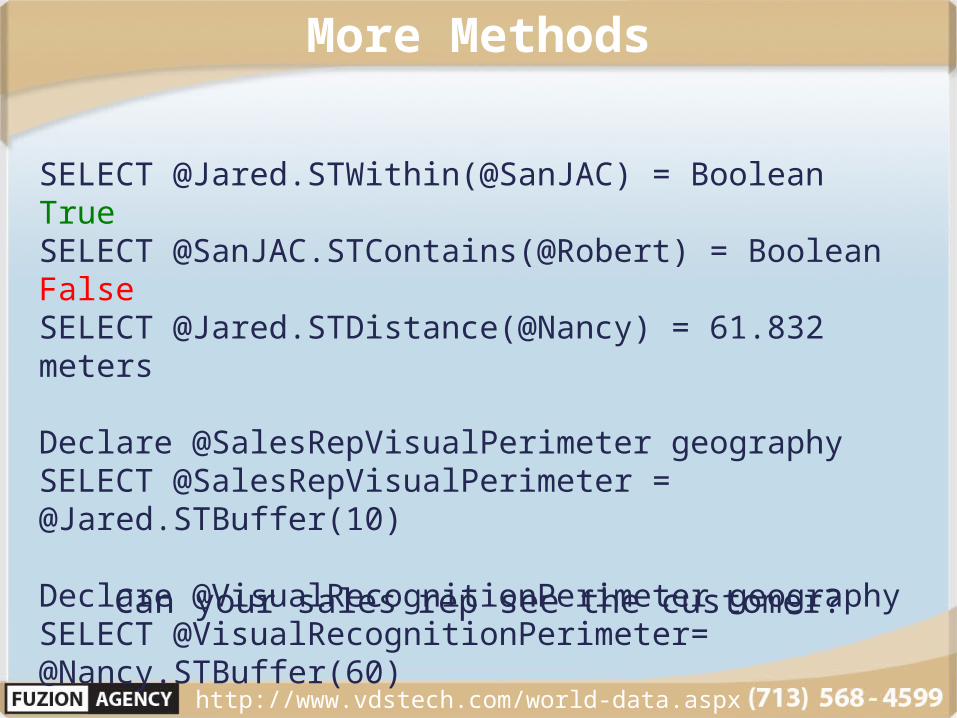
Can your sales rep see the customer?
http://www.vdstech.com/world-data.aspx
SELECT @Jared.STWithin(@SanJAC) = Boolean TrueSELECT @SanJAC.STContains(@Robert) = Boolean FalseSELECT @Jared.STDistance(@Nancy) = 61.832 meters
Declare @SalesRepVisualPerimeter geographySELECT @SalesRepVisualPerimeter = @Jared.STBuffer(10)
Declare @VisualRecognitionPerimeter geographySELECT @VisualRecognitionPerimeter= @Nancy.STBuffer(60)
More Methods
Boolean = 1= Yes http://www.vdstech.com/world-data.aspx
SELECT @VisualRecognitionPerimeter.STOverlaps(@SalesRepVisualPerimeter )

JARED NIELSENSerial Entrepreneur
InvestorSoftware Architect
Questions?


![Fuzion 5.02 [en-US] - Core Rules](https://static.fdocuments.net/doc/165x107/55cf8fa9550346703b9e84b2/fuzion-502-en-us-core-rules.jpg)
