SOIL CONSERVATION IN A FORESTED MOUNTAIN CATCHMENT
10
EQA – Environmental quality / Qualité de l’Environnement / Qualità ambientale, 33(2019) 27-36 DOI: 10.6092/issn.2281-4485/8496 27 SOIL CONSERVATION IN A FORESTED MOUNTAIN CATCHMENT Josef Křeček (1)* , Jana Nováková (2) , Ladislav Palán (1) , Eva Pažourková (1) (1) Department of Hydrology, Czech Technical University, Prague, Czech Republic (2) Independent botanist, Prague, Czech Republic * Corresponding author E.mail: [email protected] Abstract In 1982–2015, environmental impacts of commercial forestry practices were studied in the Jizerka experimental catchment (the Jizera Mountains, Czech Republic). Skidding the timber by wheelled tractors caused 10.3 km -1 of skid trails and the drainage density increased from 1.45 to 7.55 km -1 . On the harvested runoff plots, not affected by skid trails, the loss of soil 0.007 - 0.014 mm year -1 was comparable with undisturbed forests. But, the eroded soil in skid trails reached 6.17 mm (61.73 m 3 ha -1 ) by harvesting 23,882 m 3 of timber (i.e. 0.25 m 3 per 1 m 3 of harvested timber). At the catchment outlet, sediment yield reached 25% of the soil eroded. Natural regeneration of erosion rills was supported particularly by the development of herbaceous vegetation. In 2003, twelve years after the logging, only 1.5 km (15 %) of active deeper rills were still identified. Keywords: mountain catchment, acid rain, forestry practices, soil erosion, natural recovery. Introduction Topsoil erosion has been supposed as the most ultimately destructive process of soil degradation (Hillel, 2008). It results in the loss of soil productivity and off-site effects by mobilisation of agricultural chemicals and deposition of sediments. In the landscape-scale, Forman (1995) articled the role of forests as benefits on reducing drainage network connectivity, stabilisation of slopes, and protection of soil and water quality. In Europe, approx. 70 percent of forests are controlled by management plans, and 25 percent are registered as forests of non-wood services with priorities in soil and water conservation (FOREST EUROPE, 2015). Effects of commercial forest practices on soil erosion are reported by O’Loughlin and Pearce (1984), Akbarimehr and Naghdi (2012), but, there are still uncertainties in their broader environmental consequences. In the 1980s, in central Europe, the acid rain calamity lead to large-scale forest dieback and extensive timber harvest. The aim of this study is to analyze effects of forest clear cutting on drainage connectivity, soil erosion and sedimentation, and the natural recovery of a small headwater catchment in the Jizera Mts. (Czech Republic), 1982-2015.
Transcript of SOIL CONSERVATION IN A FORESTED MOUNTAIN CATCHMENT
EQA – Environmental quality / Qualité de l’Environnement / Qualità ambientale, 33(2019) 27-36
DOI: 10.6092/issn.2281-4485/8496
27
SOIL CONSERVATION IN A FORESTED MOUNTAIN CATCHMENT
Josef Křeček
(1)*, Jana Nováková
(2), Ladislav Palán
(1), Eva Pažourková
(1)
(1)
Department of Hydrology, Czech Technical University, Prague, Czech Republic (2)
Independent botanist, Prague, Czech Republic
* Corresponding author E.mail: [email protected]
Abstract
In 1982–2015, environmental impacts of commercial forestry practices were
studied in the Jizerka experimental catchment (the Jizera Mountains, Czech
Republic). Skidding the timber by wheelled tractors caused 10.3 km-1
of skid trails
and the drainage density increased from 1.45 to 7.55 km-1
. On the harvested runoff
plots, not affected by skid trails, the loss of soil 0.007 - 0.014 mm year-1
was
comparable with undisturbed forests. But, the eroded soil in skid trails reached 6.17
mm (61.73 m3 ha
-1) by harvesting 23,882 m
3 of timber (i.e. 0.25 m
3 per 1 m
3 of
harvested timber). At the catchment outlet, sediment yield reached 25% of the soil
eroded. Natural regeneration of erosion rills was supported particularly by the
development of herbaceous vegetation. In 2003, twelve years after the logging,
only 1.5 km (15 %) of active deeper rills were still identified.
Keywords: mountain catchment, acid rain, forestry practices, soil erosion, natural
recovery.
Introduction
Topsoil erosion has been supposed as the most ultimately destructive process of
soil degradation (Hillel, 2008). It results in the loss of soil productivity and off-site
effects by mobilisation of agricultural chemicals and deposition of sediments. In
the landscape-scale, Forman (1995) articled the role of forests as benefits on
reducing drainage network connectivity, stabilisation of slopes, and protection of
soil and water quality. In Europe, approx. 70 percent of forests are controlled by
management plans, and 25 percent are registered as forests of non-wood services
with priorities in soil and water conservation (FOREST EUROPE, 2015). Effects
of commercial forest practices on soil erosion are reported by O’Loughlin and
Pearce (1984), Akbarimehr and Naghdi (2012), but, there are still uncertainties in
their broader environmental consequences. In the 1980s, in central Europe, the acid
rain calamity lead to large-scale forest dieback and extensive timber harvest. The
aim of this study is to analyze effects of forest clear cutting on drainage
connectivity, soil erosion and sedimentation, and the natural recovery of a small
headwater catchment in the Jizera Mts. (Czech Republic), 1982-2015.
J. Křeček, J. Nováková, L. Palán, E. Pažourková, EQA, 33 (2019) 27-36
28
Material and methods
Study area
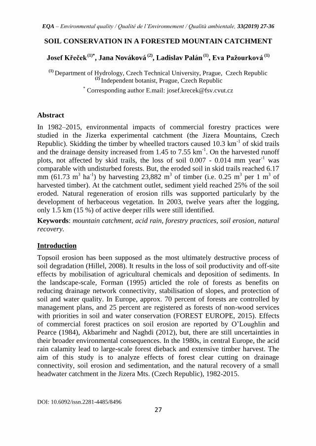
The study was performed in the upper plain of the Jizera Mts. (Fig. 1): the Jizerka
experimental catchment (50o48’21” - 50
o48’59”N, 15
o19’34” - 15
o20’48” E, Elbe
river district 1-05-01-004) operating since 1981.
950
900
860
GS – Outlet gauging station
– Region of the Jizera Mountains
– Contour map of the exp. catchment
GS
– Runoff plots A and B
A
B
TR
TR – Investigated transect
Figure 1
Jizera Mts. Region and the
Jizerka experimental
catchment.
This area belongs to the North temperate climate zone (Kőppen Dfc - sub-arctic
region) with mean annual precipitation 1,400 mm, and mean annual air temperature
4oC (Tolasz, 2007). Low-base-status soils (sandy-loamy Podzols) developed on
porphyritic granite achieves the depth from 0.5 to 1.2 m. Native forests include
namely Norway spruce (Picea abies) and Common beech (Fagus sylvatica), but
spruce plantations dominate since the second half of the 18th century. In the 1980s,
the acid atmospheric deposition, followed by insect epidemics, defoliation and
large-scale die-back of spruce plantations leaded to a forest calamity. After the
clear-cut (1984–1988), grass communities Junco effusi-Calamagrostietum villosae
became dominant, and has prolonged the forest regrowth (Křeček et al., 2010).
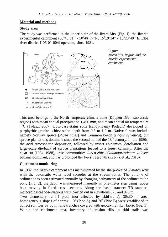
Catchment monitoring
In 1982, the Jizerka catchment was instrumented by the sharp-crested V-notch weir
with the automatic water level recorder at the stream-outlet. The volume of
sediment has been estimated annually by changing bathymetry of the sedimentation
pond (Fig. 2): the depth was measured manually in one-meter step using rubber
boat moving in fixed cross sections. Along the basin transect TR standard
meteorological observations were carried out in elevations 875 and 975 m.
Two elementary runoff plots (not affected by skid-trails), 30x30 m area,
homogeneous slopes of approx. 10o (Plot A) and 20
o (Plot B) were established to
collect soil loss by 30 m long trenches covered with geotextile filter fabric (Fig. 1).
Within the catchment area, inventory of erosion rills in skid trails was
EQA – Environmental quality / Qualité de l’Environnement / Qualità ambientale, 33(2019) 27-36
DOI: 10.6092/issn.2281-4485/8496
29
accomplished in summer months of 1983 (before the harvest), 1985, 1990, 1995,
2003 and 2015.
Figure 2
The Jizerka
catchment after
the forest
harvest (1999).
The volume of erosion rills V (m3) was calculated by the volumetric equation [1]
V = ∑ 0.5 (Ai-1 + Ai) D [1]
where: Ai – area of crossection i (m2), Ai-1 – area of crossection i-1 (m2), D –
distance between crossections (m).
Renard et al. (1997) proposed the empirical concept of revised universal soil loss
equation (RUSLE) to predict the loss of soil by water erosion [2]
A = E I30 K (L/72.6)m (a sin Θ + b) C P [2]
where: A – average annual soil loss (tons acre-1 year-1), E – storm rainfall energy
(102 foot-tons acre-1), I30 – maximum rainfall intensity in a 30 minute period
within a storm (inch hour-1), K – soil erodibility factor (-), L – slope length (feet),
m – slope length exponent, Θ – slope angle (degrees), a, b – coefficients in function
making up slope term – values depend on slope (-), C – cropping management
factor (-), P – conservation practice factor (-).
The size of eroded soil in the skidding lines was compared with the extent of
harvested areas and volumes of harvested timber. On the whole, 156
phytosociological relevès (squares of 4 x 4metres) were investigated to analyse the
herb layer development: this monitoring included 53 deep, 33 medium and 38
shallow rills, 15 plots with dead spruce stands, and 17 clear-cut spots. In the
implemented phytosociological relevès, all species abundance was estimated, and
the data transformed from Braun-Blanquet scale to 9-point scale of Van der Maarel
(1979). Using the information on higher plants only, following characteristics were
evaluated: percentage cover of herb layer; species richness (total species number
J. Křeček, J. Nováková, L. Palán, E. Pažourková, EQA, 33 (2019) 27-36
30
per relevè); life form categories of Raunkiaer (1934) according to Ellenberg et al.
(1992). ANOVA statistics was used to test differences in the vegetation features
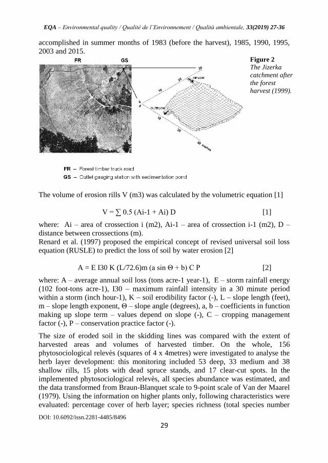
among particular stands and age groups. The archive of LANDSAT imagery
(NASA, 2014) was used to identify changes in the vegetative cover in the studied
catchments (resolution of 30 m) in 1983–2016. Only clear-sky images collected in
the high summer (June-August) were taken into account. From the multi-band
raster images, five canopy classes were identified in the consecutive years 1983 –
2015 (Křeček and Krčmář, 2015). These classes (mature spruce forests, stands of
the crown closure above 0.3, reforested plots with the crown closure below 0.3,
areas covered only by grass communities, and clear-cut) correspond with the
definition of “forest” used by the United Nations Framework Convention on
Climate Change: crown closure > 0.3, and height >2–5 m at maturity), Sasaki and
Putz (2009).
Results
Canopy changes
Initially, the Jizerka catchment was covered by mature spruce stands. In 1984, 62
% of the catchment area was harvested by clear-cutting, and about 88 % was
harvested at the end of the 1980s. Canopy changes in 1982-2015 were
reconstructed from the multi-band imagery (Fig. 3).
Figure 3
Canopy in the
Jizerka
catchment,
1983-2010
(CD – crown
closure of trees).
Drainage network development
In the Jizerka catchment, before the forest harvest (Fig. 4), the drainage network
was formed by 1,490 m of stream channels, the drainage density was 1.45 km-1
exceeding five times the value of 0.26 km-1
considered by Pallard et al. (2009) as
critical for the risk of flooding. In 1984-1990, 10.3 km of skidding trails originated
with the timber harvest; 6.1 km of rills deeper than 25 cm were directly connected
with the existing drainage system. Thus, the drainage density increased from 1.45

EQA – Environmental quality / Qualité de l’Environnement / Qualità ambientale, 33(2019) 27-36
DOI: 10.6092/issn.2281-4485/8496
31
to 7.55 km-1
. With the natural regeneration, in 2003, only 1.5 km of active deeper
rills (connected with the drainage network) and 1 km of shallow rills were
identified (Fig. 4), and this situation did not change in 2015.
Figure 4 Drainage
network and
erosion rills in
the Jizerka
catchment
before (1983)
and after the
forest harvest
(1990, 2003).
Soil erosion loss and sedimentation
Considering RUSLE parameters in the Jizerka catchment (Fig. 1), the maximum 30
minute rainstorm intensity I30 = 39 mm, soil erodibility factor K = 0.26, and
alternative values of the cropping management factor C (0.002 – coniferous forests,
0.09 – grassland, and, 0.325 - disturbed forest land, according to Panagos et al.,
2015). The predicted loss of soil achieves maximum values 0.0239 t ha-1
year-1
(spruce stands), 1.38 t ha-1
year-1
(grassland) and 5.01 t ha-1
year-1
(disturbed forest).
Thus, for the scenario of clear-cut disturbances at Jizerka, predicted loss of soil
might reach maximum 30 mm per year in extreme hill sites. Annual values of the
soil loss observed in harvested runoff plots A and B are relatively small at both
slopes (10o and 20
o): 0.007 and 0.014 mm year
-1 corresponding with those of
undisturbed forests (Elliot et al., 1996). These plots were not damaged by skid
trails, thus, the litter cover and herbaceous understory protected well the soil
surface.
Figure 5
Soil loss and annual
precipitation in the
runoff plots A and B.

J. Křeček, J. Nováková, L. Palán, E. Pažourková, EQA, 33 (2019) 27-36
32
The washed soil included particles of raw humus (65%) and fine sand (35%). In the
higher slope (plot B), there is a significant correlation of the annual loss of soil
with annual precipitation (R = 0.79, Rcrit = 0.71, p = 0.05, n = 8), contrary to the
lower slope (plot A), Fig. 5.
The development of erosion rills and volume of eroded soil with the harvest of
timber (and reduce in the area of mature stands) is given in Fig. 6. After the timber
harvest, in 1990, the total length of 10.3 km significant skid trails represented
volume of 8,122 m3
erosion rills. From ten detailed skid trail profiles on slopes 5 –
15o, there was found in average 24% of that volume lost by crushing out and soil
compaction.
Figure 6
Cumulative growth of
rills and eroded volume
of soil with forest
harvest: the Jizerka
catchment (1982-1990).
Therefore, in 1984 – 1990, the total transport of soil from the network of erosion
rills was approx. 6,173 m3 (i.e. 61.73 m
3 ha
-1, or 6.17 mm). By the harvest of
23,882 m3 of timber (i.e. 238.82 m
3 ha
-1), the loss of soil was 0.25 m
3 per each 1 m
3
of harvested timber. Annual values of sediment yield observed at the catchment
outlet are in Fig. 7.
Figure 7
Annual sediment yield
and length of active
erosion rills: the Jizerka
catchment (1980-2015).
Before the harvest (1982-1983), the annual sediment yield was 0.01 mm year-1
;
while in the harvest period (1984-1990), the total yield of sediment was 1.34 mm

EQA – Environmental quality / Qualité de l’Environnement / Qualità ambientale, 33(2019) 27-36
DOI: 10.6092/issn.2281-4485/8496
33
(i.e. 0.19 mm year-1
). Thus, in the harvest period, sediment yield increased 19
times, and accomplished 22% of the volume of soil (6.17 mm) transported from the
network of erosion rills (skid trails). In 1991-2015, the length of active erosion rills
has decreased from 10.3 to 2.5 km by natural regeneration (Fig. 7); the total
volume of sediment yield 1,525 m3
represents 25% of the eroded soil in the skid
trails (6,156 m3).
Natural recovery of skid-trails
In the Jizerka catchment, a long-term defoliation of spruce stands and the extended
clear-cut led to relatively low species richness in herb layers with dominating
Calamagrostis villosa. In all investigated relevès, only 48 plant species were
identified; the stand characterization included: dead forests with the herb layer
covering 100% of the area and low number of species (maximum 6 per relevè),
forest clearings with the herb cover 95-100% and number of species 5-10, middle
erosion rills (between 25 and 50 cm) with plant cover 20-75%, and species richness
4-9, and deep erosion rills (depth above 50 cm) with plant cover only 1-30% and
variable species richness (1-9). The species composition in forest clearings is
associated with the harvested forest type and former composition of the herb layer
(Nováková and Křeček, 2006). Plant cover was affected particularly by the depth
of erosion rills (R2 = 0.42), few species were present noticeably rarely in the
middle and deep rills in comparison with the other stands (e.g. Calamagrostis
villosa, Galium harcynicum, Vaccinium myrtillus). Considering growth forms, the
percentage of plants forming tillers decline gradually from clearings and dead
forests (almost 40%) to shallow (33%) and deep rills (29%), in the same direction,
the proportion of plants forming clusters increased from 60 to 71%. Within the life
forms, hemicryptophytes dominate, they form 70-80% of species present in rills
and dead forest stands against only 60% present in clear-cut areas. Only a weak
positive correlation (R = 0.21, p = 0.091) was found between the species richness
and slope. After the forest harvest, a relatively fast natural rehabilitation of shallow
rills (depth below 25 cm) was observed: about 15% of their surface has been
covered by grass (mainly hemicryptophytes) in 3 years, and 80% in 10 years after
timber skidding. In deep rills, there is slightly higher proportion of stress-tolerant
plants (45%) in comparison with shallow rills.
Discussion and conclusions
Before the timber harvest, in the Jizerka catchment, the annual sediment yield (0.01
mm year-1
) is below the approximate annual soil genesis (0.036 mm year-1
, given
for a mountain environment in the humid temperate climate by Vladychenskiy,
2009); but, the clear-cut (1984-1990) led to exceeding the rate of soil genesis by
four times in 12 consecutive years of 1984-1995. In 1996-2015, the sediment yield
(0.021 mm year-1
) is back below the rate of soil formation. However, still in 1996-
2015, the mean annual sediment yield (0.021 mm year-1
) is higher in comparison

J. Křeček, J. Nováková, L. Palán, E. Pažourková, EQA, 33 (2019) 27-36
34
with values (0.01 mm year-1
) before the harvest (1982-1984). After the forest
harvest, a relatively fast natural rehabilitation of shallow rills (depth below 25 cm)
was observed: about 15 % of their surface has been covered by grass (mainly
hemicryptophytes) in 3 years, and 80 % in 10 years after timber skidding. The rate
of erosion in skid trails is driven particularly by their depth and slope (Elliot et al.,
1996); but, the depth of rills depends also on the frequency of timber skidding and
hydrological conditions (Nearing et al., 1997). In deep rills at Jizerka was found a
higher proportion of stress-tolerant plants (45%) in comparison with shallow rills;
it confirms the low nutrient availability at the places where the top soil horizon was
removed (Urbanska and Fattorini, 2000). In Central Europe, 250 years tradition of
sustainable forest management has respected the ecosystem approach on multiple
functions as well as conservation of soil and water (Spathelf, 2010). However,
exogenic calamities (like the large scale acid rain impact) could affect this
approach for a relatively longer period. In the Jizerka catchment, the signs of
higher sediment runoff are remarkable from 1984 to 2015. There are several
management practices used in forestry operations to mitigate the impact of logging,
forest road and skid trail construction on stream water quality (Wallbrink and
Croke, 2002, Spathelf, 2010): these practices are designed to control erosion and to
minimize the delivery of sediments to drainage lines. Theoretically, with respect of
those regulations in the forest clear-cut at Jizerka, it was possible to avoid the
significant loss of soil by keeping the benefit of reducing the acid atmospheric load
(Křeček et al., 2017).
Aknowledgements
This research was supported by the Earthwatch Institute (Oxford, UK, Project on
Mountain Waters of Bohemia, 1991–2012), the Czech Ministry of Education
(INTER-EXCELLENCE: INTER-COST LTC 17006, 2017) and the Czech
Technical University in Prague (SGS16/140/OHK1/2T/11, 2016-2017).
References
AKBARIMEHR M., NAGHDI,R. (2012) Reducing erosion from forest roads and skid
trails by management practices. Journal of Forest Science, 58:165–169.
ELLENBERG H., WEBER H.E., DULL R., WIRTH V., WERNER W., PAULISSEN D.
(1992) Zeigerwerte von Pflanzen in Mitteleuropa. Scripta Geobotanica, 18:1-258.
FAO (2008) Forests and water, FAO Forestry paper 155, Food and Agriculture
Organization of the United Nations, Rome, Italy, 78 p.
FOREST EUROPE (2015) State of Europe’s Forests 2015, Ministerial Conference on the
Protection of Forests in Europe, FOREST EUROPE Liaison Unit Madrid, Spain, 312 p.
FORMAN R.T.T. (1995) Land Mosaics. The Ecology of Landscapes and Regions,
Cambridge University Press, Cambridge, 656 p.
HILLEL D. 2008. Soil in the Environment, Academic Press, Cambridge, 320 p.
KŘEČEK J., HOŘICKÁ Z. (2001) Degradation and recovery of mountain watersheds: the
Jizera Mountains, Czech Republic. Unasylva 52:43-49.
EQA – Environmental quality / Qualité de l’Environnement / Qualità ambientale, 33(2019) 27-36
DOI: 10.6092/issn.2281-4485/8496
35
KŘEČEK, J., NOVÁKOVÁ J., HOŘICKÁ Z. (2010) Ellenberg’s indicator in water
resources control: the Jizera Mountains, Czech Republic. Ecological Engineering, 36:1112-
1117.
KŘEČEK J., KRČMÁŘ V. (2015) Landsat imagery applications to identify vegetation
recovery from acidification in mountain catchments. Hungarian Geographical Bulletin,
64:121–126.
KŘEČEK J., PALÁN L., STUCHLÍK E. (2017) Acid atmospheric deposition in a forested
mountain catchment. iForest 10:680-686.
NASA (2014) Landsat science, http://landsat.usgs.gov, accessed on the 24th October 2016.
NOVÁKOVÁ J., KŘEČEK J. (2006) Soil erosion and plant succession at clear-cut areas in
the Jizera Mountains, Czech Republic. Ecology (Brastislava) 25:259-269.
O’LOUGHLIN C.L., PEARCE A.J. (1984) Symposium on Effects of Forest Land Use on
Erosion and Slope Stability, Environment and Policy Institute East-West Center, University
of Hawaii, Honolulu, 310 p.
PALLARD B., CASTELLARIN A., MONTANARI A. (2009) A look at the links between
drainage density and flood statistics. Hydrology and Earth System Sciences, 13:1019–1029.
PANAGOS, P., BORELLI, P., MEUSBURGER, K., ALEWELL C.; LUGATO E.;
MONTANARELLA L. (2015) Estimating the soil erosion cover-management factor at the
European scale. Land Use Policy, 48:38–50.
RAUNKIAER C. (1934) The Life Forms of Plants and Statistical Plant Geography. Oxford
University Press, Oxford, 632 p.
RENARD K.G., FOSTER G.R., WEESIES G.A., McCOOL D.K., YODER D.C. (1997)
Predicting Soil Erosion by Water: A Guide to Conservation Planning with the Revised
Universal Soil Loss Equation (RUSLE), USDA Agriculture Handbook 703, USDA-ARS,
Tucson, Arizona, 404 p.
SASAKI N., PUTZ F.E. (2009) Critical need for new definitions of “forest” and “forest
degradation” in global climate change agreements. Conservation Letters, 2:1-7.
SPATHELF P. (2010) Sustainable Forest Management in a Changing Word: A European
Perspective. Springer, Dordrecht (the Netherlands), 263 p.
TOLASZ R. (2007) Climate Atlas of the Czech Republic, Czech Hydrometeo-rological
Institute, Prague, Czech Republic, 256 p.
URBANSKA K.M., FATTORINI M. (2000) Seed rain in high-altitude restoration plots in
Switzerland. Restoration Ecology, 8:74-79.
VAN DER MAAREL E. (1979) Transformation of cover-abundance values in
phytosociology and its effect on community similarity. Vegetatio, 39:97-114.
VLADYCHENSKIY A.S. (2009) Genesis of Soil and Factors of the Soil Formation, in
Glazovsky, G.N., Zaitseva, N. (eds) Environment Structure and Function: Earth System,
Encyclopedia of Life Support Systems, EOLSS, Oxford, United Kingdom, 95-107.
WALLBRINK P.J., CROKE G. (2002) A combined rainfall simulator and tracer approach
to assess the role of Best Management Practices in minimising sediment redistribution and
loss in forests after harvesting. Forest Ecology and Management, 170:217–232.
J. Křeček, J. Nováková, L. Palán, E. Pažourková, EQA, 33 (2019) 27-36
36
CONSERVATION DES SOLS EN BASIN DE MONTAGNE FORESTIER
Résumé
De 1982 à 2015, les impacts environnementaux des pratiques forestières commerciales ont été
analysées dans le basssin experimental Jiserka situé dans les montagnes Jizera en République tchèque.
Le débusquage d’arbres par les tracteurs à roues ont causé l’envasement des sentiers sur 10.3 km-1 et
l’augmentation de la densité de drainage passant de 1.45 to 7.55 km-1. Sur les parcelles de
ruissellements récoltées non affecté par l’envasement des sentiers, la perte annuelle des sols de 0.007 à
0.014 mm 0.007 - 0.014 mm-1 était comparable avec les forêts où il n’y a pas de pratiques forestières
commerciales. Mais le sol érodé dans les sentiers envasés a atteint 6.17 mm (61.73 m3 ha-1) par la
récolte de 23,882 m3 de bois (c-à-d. 0.25 m3 par 1 m3 de bois récolté). À la sortie de captage, le
rendement sédimentaire du sol érodé a atteint 25%. La regénération naturelle de l’érosion des
ruissellements était compensée par la végétation herbacée. In 2003, douze années plus tard, seulement
1.5 km (15 %) des zones de ruissellements actifs étaient toujours repertoriées.
Mots-clés: bassin de montagne; pluie acide; pratiques forestières; érosion du sol; récupération
naturelle.
CONSERVAZIONE DEL SUOLO IN UN BACINO MONTANO BOSCATO
Riassunto
Gli impatti ambientali delle utilizzazioni forestali sono stati studiati fra il 1982 ed il 2015 nel bacino
sperimentale di Jizerka (Jizera Mountains, Repubblica Ceca). Il trascinamento dei tronchi per mezzo
di trattori forestali ha causato la formazione di 10.3 km-1 di piste di esbosco ed un aumento della
densità di drenaggio da 1.45 to 7.55 km-1. In partelle sperimentali sottoposte a taglio ma non
interessate da piste di esbosco la perdita di suolo variava fra 0.007 - 0.014 mm year-1, risultando
confrontabile con quella della foresta indisturbata. L’erosione del suolo lungo le piste di esbosco, al
contrario, raggiungeva 6.17 mm (61.73 m3 ha-1) rispetto all’asportazione di 23,882 m3 di legname
(0.25 m3 per 1 m3 of legname). Alla sezione di chiusura del bacino la produzione di sedimento
risultava pari al 25% del suolo eroso. La rigenerazione naturale dei solchi di erosione è stata
determinata principalmente dallo sviluppo di vegetazione erbacea. In 2003, dodici anni più tardi, solo
1.5 km (15 %) dei solchi di erosione attivi più profondi potevano ancora essere identificati.
Parole chiave: bacino montano; piogge acide, pratiche forestali; erosione del suolo; ripristino
naturale