Seattle Design Commission - 2014.09.16 SR 520 Montlake Lid ... · If WSDOT proceeds with a cable...
16
Ed Murray Mayor Diane Sugimura Director, DPD Marshall Foster Planning Director, DPD Osama Quotah, Chair Shannon Loew, Vice Chair Bernie Alonzo Brodie Bain Lee Copeland Thaddeus Egging Megan Groth Martin Regge Ellen Sollod Ross Tilghman Michael Jenkins Director Valerie Kinast Coordinator Nicolas Welch Planner Joan Nieman Administrative Staff MEMORANDUM To: Honorable Mayor Ed Murray Seattle City Councilmembers From: Seattle Design Commission Date: September 17, 2014 Subject: Seattle Design Commission recommendations for the Portage Bay Bridge and Montlake Lid components of the SR 520 Replacement Project Dear Mayor Ed Murray and Councilmembers: The Seattle Design Commission (SDC) is pleased to provide our comments on the conceptual design development and urban integration of two key elements of the State Route (SR) 520 project: replacement of the Portage Bay Bridge and the creation of a structure over portions of SR 520 near Montlake Blvd E (Montlake Lid). This memo provides the Mayor and City Council with the SDC’s recommendations on questions of urban design for these two critical components of the SR 520 project. The Seattle City Council requested the SDC’s review of these project elements as part of their 2012 Resolution (Resolution 31427) concerning this key transportation corridor. This resolution included a request that SDC review these two project elements before the Washington State Department of Transportation (WSDOT) proceeds with funding requests to the Washington State Legislature. WSDOT has indicated that they are ready to proceed with funding for these project elements in the 2015 legislative session. Department of Planning and Development 700 5th Avenue, Suite 2000 PO Box 34019 Seattle, WA 98124-4019 TEL 206-615-1349 FAX 206-233-7883 seattle.gov/dpd
Transcript of Seattle Design Commission - 2014.09.16 SR 520 Montlake Lid ... · If WSDOT proceeds with a cable...

Ed Murray Mayor
Diane Sugimura Director, DPD
Marshall Foster Planning Director, DPD
Osama Quotah, Chair
Shannon Loew, Vice Chair
Bernie Alonzo
Brodie Bain
Lee Copeland
Thaddeus Egging
Megan Groth
Martin Regge
Ellen Sollod
Ross Tilghman
Michael Jenkins Director
Valerie Kinast Coordinator
Nicolas Welch Planner
Joan Nieman Administrative Staff
MEMORANDUM
To: Honorable Mayor Ed Murray
Seattle City Councilmembers
From: Seattle Design Commission
Date: September 17, 2014
Subject: Seattle Design Commission recommendations
for the Portage Bay Bridge and Montlake Lid
components of the SR 520 Replacement Project
Dear Mayor Ed Murray and Councilmembers:
The Seattle Design Commission (SDC) is pleased to
provide our comments on the conceptual design
development and urban integration of two key elements
of the State Route (SR) 520 project: replacement of the
Portage Bay Bridge and the creation of a structure over
portions of SR 520 near Montlake Blvd E (Montlake Lid).
This memo provides the Mayor and City Council with the
SDC’s recommendations on questions of urban design
for these two critical components of the SR 520 project.
The Seattle City Council requested the SDC’s review of
these project elements as part of their 2012 Resolution
(Resolution 31427) concerning this key transportation
corridor. This resolution included a request that SDC
review these two project elements before the
Washington State Department of Transportation
(WSDOT) proceeds with funding requests to the
Washington State Legislature. WSDOT has indicated that
they are ready to proceed with funding for these project
elements in the 2015 legislative session.
Department of Planning and Development 700 5th Avenue, Suite 2000 PO Box 34019 Seattle, WA 98124-4019
TEL 206-615-1349 FAX 206-233-7883 seattle.gov/dpd
September 17, 2014
SDC recommendations for the Portage Bay Bridge and Montlake Lid
2
To facilitate the SDC’s review, WSDOT and City staff provided three briefings to the full SDC and
five additional workshops with an SDC subcommittee. To support this work, WSDOT engaged a
roster of consultants in urban planning, urban design, landscape design, and bridge design to
illustrate and explain design options for both project elements. At the presentations to the full
SDC, interested agencies and citizens also provided comments for the SDC to consider during
our deliberations.
We understand that WSDOT has adopted the Legislature’s Least Cost Planning approach for
infrastructure funding. The SDC’s composition of design, architecture, and engineering
professionals allowed for a unique forum to balance conceptual decisions that promote quality
design with fiscal analysis of each design alternative.
Endorsement of the Project Vision and Goals
In 2012, WSDOT developed a framework outlining their vision and goals for the SR 520 corridor
in Seattle. That framework, also supported by the SDC, established a broader urban design
framework beyond SR 520’s role as a key regional transportation corridor. In 2014, WSDOT
engaged the SDC to further define a vision and goals that specifically address the Portage Bay
Bridge and Montlake Lid. The SDC continues to support WSDOT’s visions and goals for this
corridor. Given the complexity of these projects, their impacts at both the neighborhood and
regional scale, and the importance of interdepartmental collaboration to achieve success,
WSDOT’s vision and goals should be the reference point for evaluating and proceeding with
funding options for both the Portage Bay Bridge and the Montlake Lid.
Endorsement of and Recommendations for the Design Process
The SDC greatly appreciates WSDOT staff and their consultants for their focused design process,
highly collaborative engagement, and extensive reviews with the SDC. The quality of WSDOT’s
presentations added much depth to the process. The SDC also appreciates the opportunity to
have been part of the consultant selection for key projects within the SR 520 corridor. This
collaborative approach will continue to benefit the project and is invaluable for our support of
this important transportation infrastructure. We look forward to WSDOT’s continued
consultation with the SDC as it develops future RFPs, selects designers, and contracts projects
in the corridor.
We particularly appreciate WSDOT’s commitment to extend the regional multi-use trail across
Portage Bay. The SDC advocated strongly for this important feature during the 2012 Seattle
Community Design Process. As we revisit the Portage Bay segment of the corridor, we again
thank WSDOT for their earlier work on reducing lane widths and providing flexible lanes to
minimize the overall width of the bridge.
Moving forward, we hope that WSDOT will continue to engage the City of Seattle. With DPD
and SDOT actively involved in design explorations, superior solutions can emerge that stitch the

September 17, 2014
SDC recommendations for the Portage Bay Bridge and Montlake Lid
3
freeway corridor into the urban fabric and modal networks of our city. The SDC believes that
the project will suffer if WSDOT terminates its design efforts at the edge of its right-of-way. We
hope the City will remain a proactive partner in order to build on the momentum of change for
the benefit of the communities along the corridor.
The SDC also recommends that WSDOT continue its integrative approach towards project
design, with urban design at the center of design development. We recognize the time and
resources WSDOT has spent to facilitate such a comprehensive, multidisciplinary, and
interagency design process. This innovative and collaborative approach has produced context-
sensitive infrastructure that is functional and reflects the needs, concerns, and voices of diverse
and complex users, stakeholders, and community groups. We are hopeful that WSDOT will
continue to implement this process on this and other projects.
Portage Bay Bridge
Context
Portage Bay and the
surrounding
neighborhoods form a
unique environment
within Seattle. The
arrangement of hills,
water, and wetlands
forms a curved bowl that
is intimate in scale. The
surrounding built
environment includes
large institutional uses
like the University of
Washington, smaller
institutional and water-
dependent uses in
Portage Bay, and fine-
grained residential
development on the hillsides and in floating residences to the north. As is the case in other
locations within Seattle, SR 520 passes through and touches residential neighborhoods without
the buffer of large-scale commercial or industrial uses. Sensitivity to designs that buffer the
freeway from the adjacent neighborhoods is thus essential to successful integration.
The Portage Bay Bridge is one of a series of bridges interspersed throughout the city. These
bridges provide fundamental connections among Seattle’s neighborhoods. A diversity of bridge
types surrounds Portage Bay, including the high, double-deck, steel truss Ship Canal Bridge; the
September 17, 2014
SDC recommendations for the Portage Bay Bridge and Montlake Lid
4
ornate and historic University and Montlake Bridges; and the low-profile Evergreen Point
Floating Bridge. Any new bridge at Portage Bay will (and should) acquire an equally unique
identity.
Overall Recommendations
The new Portage Bay Bridge must be both a distinctive and context-sensitive element within
the family of SR 520 bridges. Given its context, the bridge should appear elegant and light and
enhance the unique character of Portage Bay. Bridge elements such as piers, abutments, and
vertical lighting poles should complement the context without mimicking the natural, historical,
or built environments. With the addition of a shared-use path, the Portage Bay Bridge helps
complete regional connectivity for all modes of users from SR 202 in Redmond to I-5 in Seattle
and beyond.
To accommodate different users within the corridor, whose use varies based on speed,
skill, and field of vision, consider any bridge design from all perspectives including on,
above, and below the bridge and from various vantage points.
Emphasize minimizing the appearance of the bridge deck and related infrastructure for
recreational users and nearby residents.
Consider the bridge within the context of the larger SR 520 network, particularly its role
as a gateway experience both entering and leaving Seattle.
Closely examine where each bridge section lands near Montlake Blvd E to the east and
10th Avenue E and Delmar Drive E to the west in order to integrate the project within
the urban fabric of each neighborhood. Pay special attention to how the design affects
deck heights at both ends and the experience and networks of cyclists and pedestrians.
Connect the shared-use path up to and over the Delmar Lid as directly as possible.
The slope of the bridge should both enhance its contextual relationship to Portage Bay
and consider the needs of cyclists and pedestrians. While we recommend that WSDOT
continue to study retaining the elegance of hugging the natural grade, this should not
come at the expense of a consistent design for the entire Portage Bay span.
Any bridge design should emphasize lightness in appearance and scale and complement
its location within Portage Bay. This is particularly important given the size and number
of columns below the deck, which should be reduced as much as possible in number and
prominence.
Integrate architectural elements within the overall design of the bridge to provide
aesthetic interest and follow a structural logic.
Design the bridge to relate to the horizon line in a logical and compelling fashion.
Maximize the amount of natural light that reaches the water and land. To accomplish
this, pursue greater horizontal separation between the east- and westbound bridge
segments.
September 17, 2014
SDC recommendations for the Portage Bay Bridge and Montlake Lid
5
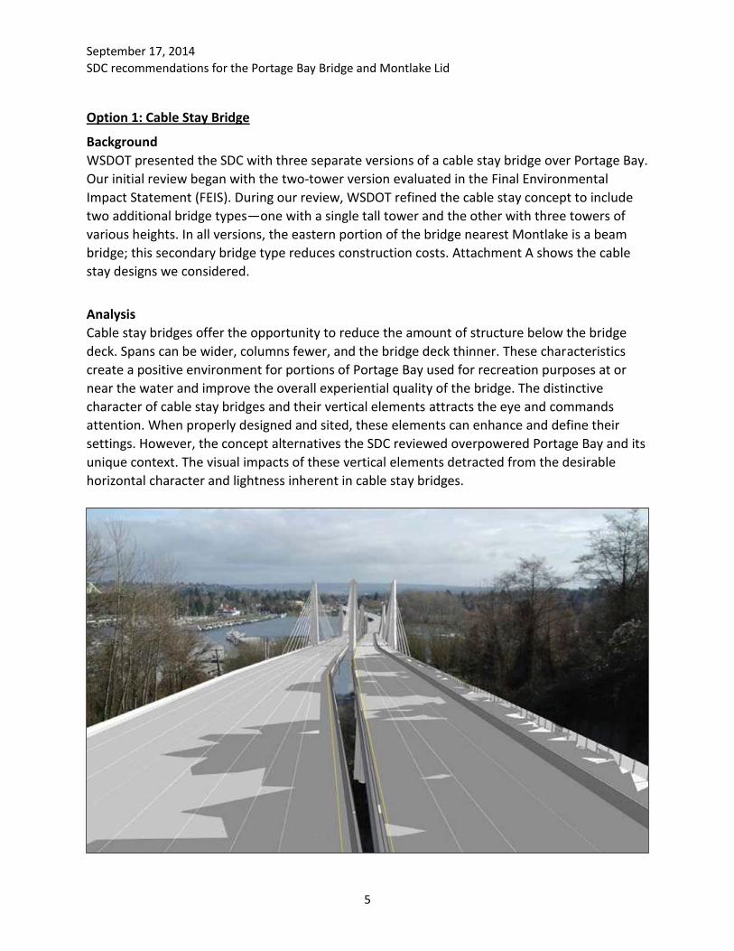
Option 1: Cable Stay Bridge
Background
WSDOT presented the SDC with three separate versions of a cable stay bridge over Portage Bay.
Our initial review began with the two-tower version evaluated in the Final Environmental
Impact Statement (FEIS). During our review, WSDOT refined the cable stay concept to include
two additional bridge types—one with a single tall tower and the other with three towers of
various heights. In all versions, the eastern portion of the bridge nearest Montlake is a beam
bridge; this secondary bridge type reduces construction costs. Attachment A shows the cable
stay designs we considered.
Analysis
Cable stay bridges offer the opportunity to reduce the amount of structure below the bridge
deck. Spans can be wider, columns fewer, and the bridge deck thinner. These characteristics
create a positive environment for portions of Portage Bay used for recreation purposes at or
near the water and improve the overall experiential quality of the bridge. The distinctive
character of cable stay bridges and their vertical elements attracts the eye and commands
attention. When properly designed and sited, these elements can enhance and define their
settings. However, the concept alternatives the SDC reviewed overpowered Portage Bay and its
unique context. The visual impacts of these vertical elements detracted from the desirable
horizontal character and lightness inherent in cable stay bridges.

September 17, 2014
SDC recommendations for the Portage Bay Bridge and Montlake Lid
6
Recommendations
After careful analysis, the SDC believes a cable stay bridge is not the most compelling option for
Portage Bay. A small number of Commissioners felt that the time allotted for the study did not
allow for a full exploration of cable stay options and that a concerted effort here could result in
an appropriate design. However, weighted against other bridge types and project
considerations, the majority of Commissioners believe a cable stay bridge to be the least
appropriate of those presented in this study.
If WSDOT proceeds with a cable stay bridge, the SDC recommends the following:
Maximize the cable stay technology to significantly reduce the profile of the bridge
deck, size of vertical elements, and number and girth of columns in the water. The
bridge should be as thin and light on the water as possible. Take great care not to create
a structure that overwhelms the scale of the Portage Bay bowl.
Leverage the bridge technology to create a dynamic and elegant formal solution to the
design.
Design the bridge lighting with consideration for the residents in the area and with the
aim of elegance rather than drama.
Option 2: Box Girder Bridge
Background
The SDC evaluated a box girder bridge and had the opportunity to help refine the design as part
of our explorations. The initial renderings presented to the SDC from the 2010 FEIS showed a
bridge with a varied slope and up to 14 columns, 11 of them in the water:

September 17, 2014
SDC recommendations for the Portage Bay Bridge and Montlake Lid
7
As our review progressed, WSDOT refined the design to have a uniform slope, which enhances
the non-motorized experience. The refined design also reduced the number of columns,
resulting in reduced environmental impacts. Attachment B shows the box girder designs we
considered.
Analysis
A box girder bridge is a utilitarian solution that places function above form and aesthetics. It is
commonly seen as part of the American highway bridge vernacular. The box girder is bulkier
and heavier at and below the bridge deck than the cable stay bridge. More columns are
necessary, adding to the innate heaviness of this bridge type. Because it does not have above-
deck structural elements, the box girder is horizontally oriented. While it lacks the presence of
more structurally expressive bridge types, the width of the deck and location within Portage
Bay will nevertheless have a visual impact that warrants careful consideration.
There are many examples of designs that have pushed the limits of this typology to achieve a
higher aesthetic and contextual standard. The work of the design consultants and our
experience reviewing the West Approach Bridge North make us confident that the box girder
can provide an elegant, distinctive solution. The design effort should focus on maximizing the
thinness and lightness of the bridge. The WSDOT team has already started to investigate
reducing the number of columns and adjusting the profile of the structure to minimize the
visual impacts of the bridge deck.
Recommendations
Given the analysis to date, the SDC believes that the box girder bridge has the greatest
potential for success in Portage Bay. However, to fully meet the vision and goals of this project,
the box girder bridge must be well funded in order to be designed for this place and its context.

September 17, 2014
SDC recommendations for the Portage Bay Bridge and Montlake Lid
8
If the budget is spare, the result will be a boxy, heavy highway bridge. Furthermore, architects
and urban designers must continue to play leading roles on the project team. WSDOT’s project
engineers and agency leadership must continue to explore solutions that push the boundaries
of standard design. An integrated team can develop and refine the box girder to be distinctive
and contextual.
Additional SDC design recommendations include:
Allocate funding commensurate to the project’s unique, dense location in order to
produce an exceptional bridge.
Stretch the bounds of the box girder design to create an elegant bridge that enhances
its unique location, while achieving lightness and a contemporary appearance.
Refine the strategy for the vertical elements to add visual interest and rhythm.
However, do not detract from the horizontal character and contemporary expression of
the bridge.
While the bridge should enhance the context without mimicking its historical and
natural elements, do not strip the bridge of all enhancements and leave a bare box
girder bridge in an effort to be contemporary.
Montlake Lid
Context
Prior to the construction
of SR 520, the Montlake
neighborhood was a
connected community
of single-family homes
bounded by the
Montlake Cut and
Portage Bay to the north
and west and the
Washington Park
Arboretum to the south.
Today, SR 520 isolates
the Shelby-Hamlin neighborhood and former MOHAI site on the north from the rest of
Montlake neighborhood to the south. The junction of SR 520 and Montlake Blvd E effectively
places a freeway interchange in the middle of this residential neighborhood, interfering with
bicycle and pedestrian traffic across the Montlake Cut to the University of Washington and the
future light rail station.

September 17, 2014
SDC recommendations for the Portage Bay Bridge and Montlake Lid
9
Past SDC Input
The SDC provided recommendations on the Montlake Lid concept during the 2010 EIS process
and 2012 Seattle Community Design process. In 2012, the SDC recommendations to WSDOT
included:
Maximize the qualitative and functionality of the lid space.
Prioritize non-motorized connections.
Provide activated open spaces.
Enhance the user experience.
Better integrate the program within the neighborhood and its context.
To achieve these recommendations, the SDC encouraged WSDOT and the City to explore
diverse design options and scales that would focus on quality over quantity, reduce the reliance
on disruptive mechanical equipment, increase benefits to users and neighbors, and provide
better connectivity and impact mitigation.
Endorsement of the Montlake Lid Design Refinements
The SDC endorses WSDOT’s refined concept design for a “smarter” lid. This approach identifies
the desired goals that the lid should achieve and then, through thoughtful moves, maximizes
the planning, engineering, and design of the project to meet or exceed these goals with an
emphasis on quality over quantity. Through these investigations, WSDOT balanced the SR 520
tunnel size with project goals, eliminating the need for ventilation infrastructure and operations

September 17, 2014
SDC recommendations for the Portage Bay Bridge and Montlake Lid
10
and maintenance facilities. This resulted in a thinner, less invasive lid that could effectively be
lowered by 15 feet.
Above all, the smarter lid concept achieves the following key benefits:
1. Enhanced regional connectivity
The smarter lid does not merely become a destination; the reductions in grade improve
multimodal connections along the SR 520 corridor, across the Montlake Cut, and through the
neighborhood. The primary north–south pedestrian and bicycle connection takes on a more
direct alignment above rather than beneath the highway, at a lower slope, and with greater
visual connection to the University of Washington. This allows the shoreline trail under SR 520
to become an overwater boardwalk with better visibility and connections to the Arboretum and
Foster Island. Finally, the refined design improves on the previous east–west connections to,
from, and across the lid.
2. More useable open space
The design and programming of open space in the refined concept focuses on quality usable
spaces over quantity. The goal is to provide meaningful activity and not promote unintended
uses. Spaces are functional, safe, and thoughtfully placed within the context of the
neighborhood and the network of paths and trails. Lowering the lid height improves visibility
and physical access and eliminates the need for large ventilation stacks that break up the open
space and decrease its functionality.
The refined design goes beyond the lid and thoughtfully integrates the stormwater facility at
the former MOHAI site as additional green space within East Montlake Park. This capitalizes on
stormwater infrastructure and captures it as an element of the open space network that will
extend north from the Arboretum toward the Montlake Triangle and Burke-Gilman Trail.
3. Enhanced view corridors
The project team studied grades and landscape elements to buffer views of the highway and
control roadway noise. Lowering the overall height of the lid maintains visual connectivity
throughout the neighborhood and from Lake Washington Blvd E.
4. Improved transit, bicycle, and pedestrian experiences
The design refinements improve the experience of pedestrians, cyclists, and transit users
through better undercrossings, enhanced site design, and greater connectivity. The project
team enhanced the pedestrian experience along Montlake Blvd E by expanding the lid to the
west to create a larger vegetated buffer between pedestrians and SR 520 and shortening
pedestrian crossings in this area.

September 17, 2014
SDC recommendations for the Portage Bay Bridge and Montlake Lid
11
Pathways across the lid were aligned to create convergence zones at two critical points: near
Montlake Blvd E in the form of urban trailhead and where the landbridge meets 24th Ave E.
This enhances non-motorized connections, improves transit access, and activates open space.
In addition, the concept refinements enhance the safety, functionality, and overall character of
the Bill Dawson trail by easing the grades, adjusting the trail alignment, improving sightlines,
and providing alternative routes.
5. Improved integration within the Montlake neighborhood fabric.
The reduced height, buffering of SR 520, and enhanced physical and visual connectivity of the
smarter lid create more seamless connections with the neighborhood. The landbridge
connection replaces the large retaining wall along the north side of SR 520 and creates an
enhanced landscaped edge.
Moving east to west along the SR 520 corridor, the landbridge and lid create a series of
thresholds that transition from the large landscape of Lake Washington to the urban fabric of
the city.
Recommendations for Further Design Development
While the SDC is very encouraged by the changes resulting from the smarter lid approach, this
approach also creates design challenges. As the SDC evaluated this updated approach, we also
provided a number of key recommendations to guide WSDOT and the City in further
development of the project.

September 17, 2014
SDC recommendations for the Portage Bay Bridge and Montlake Lid
12
1. Environment
Strengthen the sustainability strategy for the project as a whole, particularly as it relates
to stormwater, materiality, constructability and the integration of the project into our
larger network of open space and habitat.
2. Enhance the Sequential Gateway Experience
Consider the SR 520 as a succession of elements—the floating bridge, West Approach
Bridge North, landbridge, Montlake Lid, Portage Bay Bridge, Delmar Lid—that together
create a larger gateway experience as one moves into or out of our City. Consider the
Montlake Lid as part of this series of thresholds and clarify how it fits within that
context. The sequence of the landbridge and tunnel should work together to create this
threshold experience. Consider materiality, movement through the tunnel, and the
moment of emerging from under a structure to see Foster Island or Portage Bay.
In addition to east–west movement, consider the experience of thresholds moving
north to south along Montlake Blvd E and throughout the network of paths on the lid
and landbridge.
3. Strengthen Connectivity and Wayfinding
Develop a clear hierarchy for the paths and trails that transect the lid. This hierarchy
should be weighted to clearly indicate how paths connect to nearby and regional
destinations. Consider how people will connect to the Burke-Gilman Trail, Arboretum,
and future transit hub at the Montlake Triangle.
Continue to study grades, visual connections, desire lines, and buffers between
bicyclists, pedestrians, and vehicular traffic. Pay particular attention to the pinch points
where 24th Ave E crosses Lake Washington Blvd E and where the Bill Dawson Trail
connects to E Roanoke St.
4. Landbridge
Continue to study the landbridge typology. The bridge profile should be unique and
expressive without resembling typical highway infrastructure. Topography and
vegetation should provide a unique experience from all angles.
Resolve where the landbridge connects to the land at both ends and how it emerges
from the landscape. On the deck of the landbridge, explore widening the east edge to
provide adequate width for generous landforms and vegetation. Continue to develop
moments for pause and views, and provide opportunities to look eastward towards Lake
Washington.
5. West Lid

September 17, 2014
SDC recommendations for the Portage Bay Bridge and Montlake Lid
13
The “urban trailhead” area works as a strong placemaking gesture. Its success, however,
is crucial to the function of the lid as a hub within the city. It will be important to
proactively develop the kiosks and program the space to activate it and achieve the
desired civic outcomes.
Continue to focus on developing quality public space, especially at the west end of the
lid. Provide a good experience for non-motorized users moving across the lid and along
24th Ave E. To that end, consider increasing the amount of lid on the east side of
Montlake Blvd E at 24th Ave E.
6. Montlake Boulevard
Give as much attention to the design articulation of the west side of Montlake Blvd E as
to the east side. This is a major non-motorized route that links transit to the north with
the heart of Montlake to the south. It is also a desire line between Capitol Hill and the
UW.
Work with the property owner of the gas station site at Montlake Blvd E and Lake
Washington Blvd E to win space for transit users, cyclists, and pedestrians.
Continue to explore the idea of providing a bike and pedestrian bridge over the
Montlake Cut at a point close to where 24th Ave E would transect the waterway. This
would strengthen the connective function of the landbridge within the larger north–
south continuum between the Arboretum and the University of Washington. The SDC
has not thoroughly analyzed the question of a second bascule bridge, but in 2010 we
recommended that, if constructed, the second bascule bridge be limited to pedestrian,
cyclist, and transit use. A separate pedestrian/bicycle bridge over the Cut further east
would help alleviate pressure for a crossing close to the existing historic bridge. It would
also relieve pressure on Montlake Blvd E between SR 520 and the Montlake Triangle.
7. Ramps to Nowhere
Though not part of this review or our review of the West Approach Bridge North, the SDC
supports the idea of retaining a part of the “ramps to nowhere” at the Arboretum that are
slated for removal.
The ramps to nowhere are existing structures that relate to former plans to extend a freeway
through the Arboretum and the successful fight to stop those plans. The ramps represent an
important time in Seattle’s history and express a key personality trait of our city. Furthermore,
their presence has created unique experiences from the “unauthorized” pedestrian access to
the ramps, providing elevated views of the lake and opportunities to jump into the water. This
attracts spectators regularly. The structures provide an interesting sense of scale and a unique
contrast between the softness of nature and hardness of infrastructure. The ramps to nowhere
offer thought-provoking irony and ties to our history that, with further public art interventions

September 17, 2014
SDC recommendations for the Portage Bay Bridge and Montlake Lid
14
and safety and access improvements, could preserve and strengthen this extraordinary place in
the history of our city.
We recommend that the State and City explore the idea of retaining part of the ramps to
nowhere. They are located where plans are underway to expand recreational use as part of the
Arboretum North Entry project. There is an important opportunity to enrich that design of that
project with these socially significant relics of the past.
In closing, the SDC greatly appreciates the time and commitment that WSDOT and the City have
made in presenting this project. As the project proceeds, we look forward to continued
involvement.
CC: Diane Sugimura, DPD Director
Scott Kubly, SDOT Director
Nathan Torgelson, DPD Deputy Director
Lyle Bicknell, DPD
Bernard Van De Kamp, SDOT
Kerry Pihlstrom, WSDOT

Attachment A Cable stay bridge designs presented to the SDC
FEIS Baseline Design – two towers of equal height (each 216 feet above bridge deck)
June 17, 2014 – one tall tower (274 feet above bridge deck) and uniform 2.6% grade
July 8, 2014 – three towers of varied heights (102, 129, and 147 feet above bridge deck) and uniform 2.6% grade

Attachment B Box girder bridge designs presented to the SDC
FEIS Baseline Design
June 17, 2014
July 8, 2014