Route 79/I-195 Interchange Improvements Study · Route 79/I-195 Interchange Improvements Study ......
45
Route 79/I-195 Interchange Improvements Study Fall River, Massachusetts May 18, 2010
Transcript of Route 79/I-195 Interchange Improvements Study · Route 79/I-195 Interchange Improvements Study ......

Route 79/I-195 Interchange Improvements StudyFall River, Massachusetts
May 18, 2010

Agenda
1. Introduction2. Schedule for Study Completion3. Interchange Alternatives Evaluation (Part 2)4. Public Meeting preparations5. Discussion/next steps

Major Steps for Rte. 79/I-95 InterchangeStudy and Project
STEP 1 STEP 2 STEP 3
ValueEngineeringStudy
This study –required by FHWA –suggestedinvestigatingremoving Rte. 79Viaduct at the I-195Interchange.
April 2009
FeasibilityStudy
Detailed review ofValue EngineeringStudy to assessfeasibility ofremoving Rte 79Viaduct at the I-195Interchange.
July 2009
Planning –AlternativesStudy
The level of designat the end of thisstage is“conceptual.”
December 2009 –July 2010
STEP 4 STEP 5 STEP 6
State (MEPA) &Federal (NEPA)EnvironmentalReview
This more detailedengineering andenvironmentalanalysis will takeabout 12 monthsand the level ofdesign will bebetween 5% and10% complete.
August 2010 – May2011
PreliminaryEngineering
This marks the firstintensive designstage. This step willtake about 12-14months and thedesign at the endwill be 25%complete.
May 2011 – May 2012
Final Design orDesign/Build
This stage will takeabout 48 months.
Constructioncomplete Fall of2016
Currently Underway

1
2
3
4
5
6
7
8
Project Initiation
Goals & Objectives
Existing Conditions
No Build Analysis
Alternative Development
Alternative Analysis
ReportRecommendations
Prepare ENF
Kick-off meeting / Study area limitsCommunications / Task Force Members
Goals & Objectives / Evaluation CriteriaPurpose & Need Statement
Draft & Final Existing Conditions Summary
Traffic / Socio-economic / Land Use
Alternative Development / Screening of Alternatives
Mobility / Safety / EnvironmentalSocio-economic / Structures / Costs
Final Report / Public Meeting
Certificate from Secretary of EOEEA
June
* Current stage
Proposed Rte. 79 Interchange Study Work Flow
*Aug.–Dec.

Alternatives Evaluation and Analysis
• Level 1 Screening (March 23):– Fatal flaw analysis
– Constructability and right-of-way impacts– Mostly qualitative
Level 2 Screening
– Rigorous and mostly quantitative
– Relies on detailed definition of alternatives
– Requires conceptual level engineering

n.t.sNORTHAlternative 1A: Route 79 Interchange
New Street
Central
Wat
er S
t
Millike
n Blvd
Central St
Anawan St
Pocasset StR
amp
Y
New Traffic Signal
Ramp or One-way Street
New Street
Ramp
ARamp A+C+E
Ramp E
Ramp C
Ramp F+G
Battleship
Monument
Tunnel
Taun
ton
Riv
er
Alt. 1aRte. 79 viaduct removed;3 Rte. 79 signals

n.t.sNORTHAlternative 1B: Route 79 Interchange
New Street
Central
Wat
er S
t
Millike
n Blvd
Central St
Anawan St
Pocasset StR
amp
Y
New Traffic Signal
Ramp or One-way Street
New Street
Ramp
ARamp A+C+E
Ramp E
Ramp C
Ramp F+G
Battleship
Monument
Tunnel
Taun
ton
Riv
er
Right-in/Right-out Only
Alt. 1bRte. 79 viaduct removed;2 Rte. 79 signals

n.t.sNORTHAlternative 2: Bi-directional 1-Level Viaduct
New Street
Wat
er S
t
Millike
n Blvd
Central St
Anawan St
Pocasset StR
amp
Y
New Traffic Signal
Ramp or One-way Street
Ramp
ARamp C
Ramp E
Ram
p
Ramp F+G
Battleship
Monument
Tunnel
Taun
ton
Riv
er
1-Le
vel V
iadu
ct
C
Note: New Traffic Signals at Central St at Davol Stand Anawan St at Viaduct St underneath the 1-Level Viaduct. Viaduct
Ramp F
Bi-d
irect
iona
l
Alt. 2Rte. 79 NB and SBconsolidated;NB level removed.

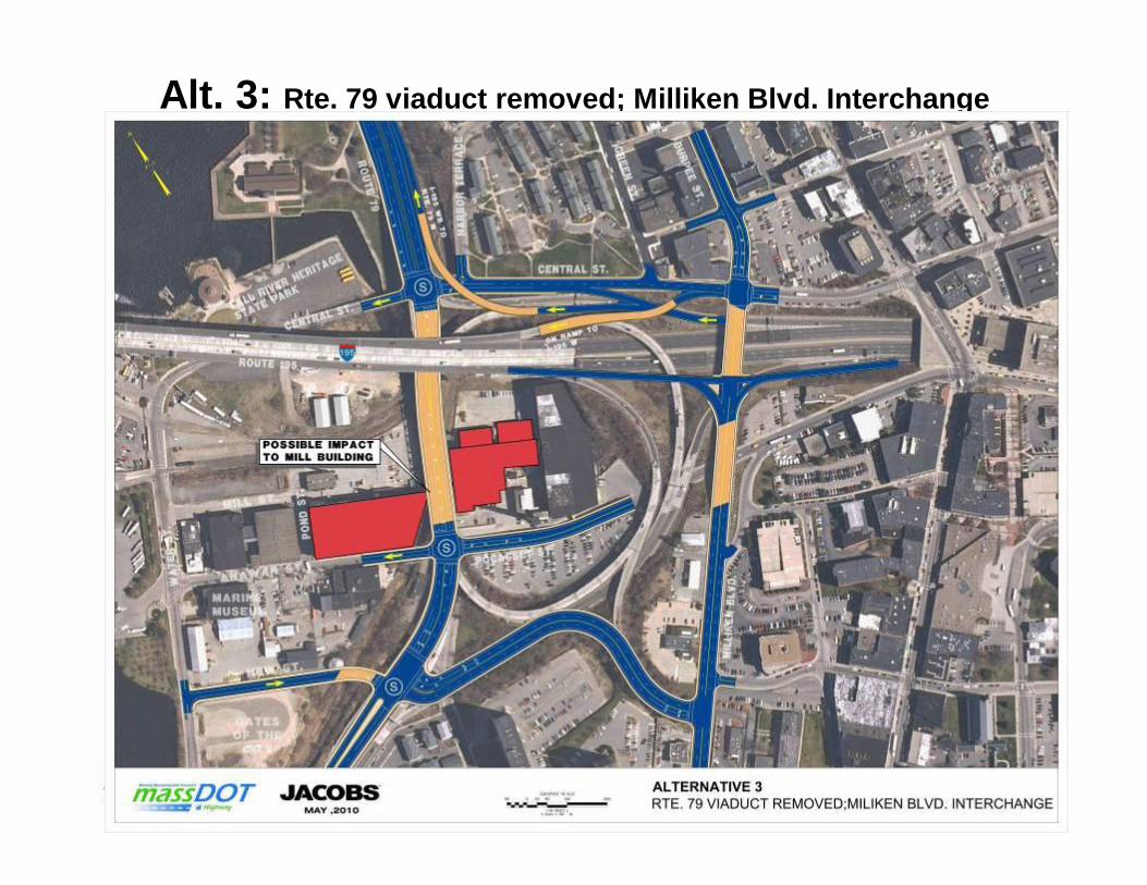
n.t.sNORTHAlternative 3: Milliken Blvd Interchange
New Street
Central
Wat
er S
t
Millike
n Blvd
Central St
Anawan St
Pocasset St
New Traffic Signal
Ramp or One-way Street
New Street
Off RampOn Ramp
Ramp Y
Ramp F+G
Battleship
Monument
Tunnel
Taun
ton
Riv
er
Right-in/Right-out Only
Ramp F
New Street
Alt. 3Rte. 79 viaduct removed;Milliken Blvd. Interchange

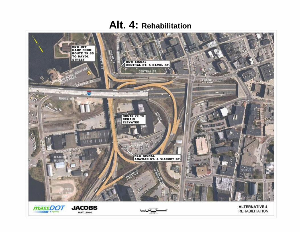
n.t.sNORTHAlternative 4: Rehabilitation of Existing
New Street
Wat
er S
t
Millike
n Blvd
Central St
Anawan St
Pocasset StR
amp
Y
New Traffic Signal
Ramp or One-way Street
Ramp
ARamp C
Ramp E
Ram
p
Ramp F+G
Battleship
Monument
Tunnel
Taun
ton
Riv
er
Ramp
D
2-Le
vel V
iadu
ct
C
Note: New Traffic Signals at Central St at Davol Stand Anawan St at Viaduct St underneath the 2-Level Viaduct. Viaduct
Alt. 4Rehabilitation

n.t.sNORTHNo-Build
New Street
Wat
er S
t
Millike
n Blvd
Central St
Anawan St
Pocasset StR
amp
Y
Ramp or One-way Street
Ramp
ARamp C
Ramp E
Ram
p
Ramp F+G
Battleship
Monument
Tunnel
Taun
ton
Riv
er
Ramp
D
2-Le
vel V
iadu
ct
C
Viaduct
No BuildRte. 79 viaduct remains;repairs done every 5-10years

Evaluation of Benefits and Impacts: Part 2
• Approx. 40 evaluation measures assess impacts &benefits related to goals and purpose
• Key measures to be reviewed today– Historic resources impacts
– Economic impacts
– Environmental impacts– Consistency with local/regional plans
– Construction-period impacts
– Local/regional traffic impacts

Vehicular Mobility Summary
• LOS at at-grade intersections does not worsenunder any alternative except No Build
• LOS at freeway and ramp junctions would notworsen under any alternative
• Speeds on I-195 would not worsen under at-gradealternatives
• Average trip lengths through interchange would beshorter under at-grade alternatives
Note: Projected traffic volumes for Alt. 3 TBD; summaryomits Alt. 3 impacts

Vehicular Mobility Summary, cont.
• Volume/capacity ratio on Rte. 79 would be <1.0for all alternatives, but viaduct alternatives havemore reserve capacity
• Vehicular capacity on Rte. 79 would beimproved with viaduct schemes over at-gradealternatives

2030 Capacity on Rte 79 Southbound
0
500
1000
1500
2000
Route 79
Cap
acity
(vph
pl)
No-Build & Alt 4 Alt 1A Alt 1B Alt 2
Anawan Street Central Street
1900 vphpl
1700 vphpl
1275 vphpl
1025 vphpl
Alt 2 No-Build, Alt 2, Alt 4
Alt 1B
No-Build, Alt 1A, Alt 4
Alt 1A, 1B[Weave Capacity Impact on No-Build & Alt 4]
[Right-in/Right-out Capacity Impact on Alt 1B]
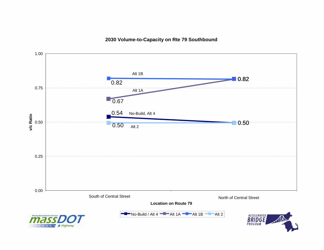
2030 Volume-to-Capacity on Rte 79 Southbound
0.50
0.820.82
0.50
0.54
0.67
0.82
0.50
0.00
0.25
0.50
0.75
1.00
1 2
Location on Route 79
v/c
Rat
io
No-Build / Alt 4 Alt 1A Alt 1B Alt 2
South of Central Street North of Central Street
No-Build, Alt 4
Alt 2
Alt 1A
Alt 1B

Safety Summary
• Local intersections would be improved under allalternatives
• Interchange safety problems would be addressedunder all alternatives except No Build andRehabilitation

Bike/Pedestrian Access Summary
• Shoulders and bike lanes on all new orreconstructed streets
• New or improved sidewalks on all new orreconstructed streets
• Signalized intersections improve conditions in allalternatives except No Build
• At-grade alternatives provide access to waterfrontvia 3 local streets

Local Access Improvements Summary
• At-grade alternatives create 3 new localstreet connections
• All at-grade alternatives reduce traveldistance by 8/10 mile to/from waterfrontfrom No Build

Roadway Context Summary
Under all alternatives:
• Functional classification (what is the primaryroadway purpose?)
Rte. 79 functional class would remain “principal arterial”; Rte.138 would remain “urban minor arterial”
• Access control (how access to adjacentproperties is regulated)
Rte. 79 would remain “limited access” with few drivewaysand signals

Design Exception Report Needed?
• Shoulder width less than minimumrecommended
• Vertical clearance less than minimumrecommended

Business & Economic ImpactsRanking of Alternatives by Economic Impact Criteria
Note: Data for Alt. 3 TBD; ranking shown is based onprofessional qualitative judgment
NOTE: 5 is Highest Rank (+)
1315132020COMPOSITE
15144Economic Development Plans
51511Displacements
13155Access to Waterfront
33355Accessibility
33355Annual Travel Time Savings
ALT 4ALT 3ALT 2ALT 1BALT 1A

Business & Economic Impacts Summary
0
5
10
15
20
25
Annual Travel TimeSavings
Acessibility Access toWaterfront
Displacements EconomicDevelopment Plans
COMPOSITE
ALT 1A
ALT 1B
ALT 2
ALT 3
ALT 4

Environmental Impacts South

Environmental Impacts North

Environmental Summary
• Environmental issues are similar for mostalternatives and are manageable
• Potential impacts to Section 4(f) parklandresources require mitigation
• Potential impacts to Chapter 91 filled tidelandswill require determination of applicability
• Other potential impacts appear to be mitigatable(e.g. storm water management)

Cultural Resources Impacts

Cultural Resources Impacts

• All at-grade alternatives except the No Build andRehabilitation alternatives would impact theAmerican Printing Co. building (National Register)
• The Central Street Bridge over the QuequechanRiver (National Register eligible) would possibly beimpacted in Alts. 1a, 1b and 3.
Cultural Resources Summary

Aesthetics Summary
• Deteriorated, blighting structures would be replaced/rehabilitated under all alternatives but the No Build
• Alt. 4 maintains same general appearance butrepainting, other repairs, and new lighting wouldimprove appearance
• Alt. 3 would eliminate the most elevated structures
• New viaduct in Alt. 2 would have fewer supports,cleaner lines…similar to ramps to new Brightman St.Bridge
• At-grade alternatives would reconstruct 4 to 5 surfacestreets

Maintenance Summary
• All structures would be improved therebyreducing long-term maintenance under allalternatives except No Build
• Alts. 1a, 1b and 3 would reduce total bridge areaand future maintenance most
• Alternative 4 would have the highest futuremaintenance cost
• Alt. 2 would have less future maintenance costthan Alt. 4 since all structures would be new

Bridge Deck Summary (SF)
287,000104,600293,500107,400114,500349,300Totals
04,80004,8004,800-New St. Bridge
021,90000034,900Milliken Blvd.
050,500043,40050,50027,400Viaduct Street
101,60027,40081,30059,20059,200101,600Ramps A-Y
185,4000212,20000185,400Rte. 79 SB &NB Viaduct
4321b1a
AlternativesExistingBridgeArea

Constructability & Traffic ManagementImpacts
4
2
3
1a & 1b
Construction Duration(Shortest to Longest)
Alternatives
ALL alternatives will require significant traffic diversions and detours

TemporaryTraffic Impacts

Constructability & Traffic Management
• Reconstruction of the Viaduct Street Bridge• Rte. 79 Viaduct needs to be demolished before
Viaduct Street can be reconstructed

Existing Sectionat Mill Buildings

Constructability & Traffic Management
• Demolition of Existing Viaduct

Demolition of Existing Viaduct
• Not Practical to Construct New “At-Grade” Roadways beforethe Viaduct is Removed

Alt. 1a: Rte. 79 viaduct removed; 3 Rte. 79 signals

Constructability & Traffic Management
• Reconstruction/Relocation of Ramps

Alt. 2: Rte. 79 NB and SB consolidated; NB level removed
Alt. 3: Rte. 79 viaduct removed; Milliken Blvd. Interchange

Constructability & Traffic Management
• Reconstruction of Milliken Blvd. Bridge– In stages to maintain traffic on Milliken
• New Ramp Construction
Alt. 4: Rehabilitation

Discussion/Next Steps
• Refine evaluation criteria• Continue detailed analysis of alternatives• Review at next Task Force Meeting• Prepare for public meeting in early June