Hi-Lake Interchange Study - Star...
53
Hi-Lake Interchange Study February 2016
Transcript of Hi-Lake Interchange Study - Star...
Hi-Lake Interchange Study
February 2016

Hi-Lake Interchange Study
Hi-Lake Interchange Study i February 2016 | FINAL
Project Management Team
Simon Blenski, City of Minneapolis
Allan Klugman, City of Minneapolis
Bob Byers, Hennepin County
Kelley Yemen, Hennepin County
Tony Drollinger, Metro Transit
Scott Janowiak, Metro Transit
Carol Hejl, Metro Transit
Bruce Otiso, Metro Transit
Gina Mitteco, MnDOT
Ron Rauchle, MnDOT
JoNette Kunhau, Kimley-Horn
John Horn, Kimley-Horn,
Chadd Larson, Kimley-Horn
William Reynolds, Kimley-Horn

Hi-Lake Interchange Study
ii Hi-Lake Interchange Study
February 2016 | FINAL
Hi-Lake Interchange Study
Hi-Lake Interchange Study iii February 2016 | FINAL
Contents
1.0 OVERVIEW OF STUDY ................................................................................................................................. 1
1.1. NEED ............................................................................................................................................................... 1
1.2. PURPOSE........................................................................................................................................................... 1
1.3. PREVIOUS STUDIES .............................................................................................................................................. 2
1.4. STUDY PROCESS ................................................................................................................................................. 2
2.0 EXISTING CONDITIONS ............................................................................................................................... 3
2.1. OPERATIONS ...................................................................................................................................................... 3
2.2. GEOMETRY ........................................................................................................................................................ 4
2.3. DEMAND ........................................................................................................................................................... 5
2.4. KEY ISSUES AND OPPORTUNITIES ......................................................................................................................... 10
3.0 EVALUATION MEASURES .......................................................................................................................... 15
3.1. DEVELOPMENT ................................................................................................................................................. 15
3.2. BASE CONDITIONS ............................................................................................................................................ 15
4.0 TIER I IMPROVEMENTS ............................................................................................................................. 18
4.1. OVERVIEW ...................................................................................................................................................... 18
4.2. IMPROVEMENT TYPES ........................................................................................................................................ 18
4.3. COSTS ............................................................................................................................................................ 24
4.4. EXPECTED OUTCOMES ....................................................................................................................................... 25
5.0 TIER II IMPROVEMENTS ............................................................................................................................ 26
5.1. OVERVIEW ...................................................................................................................................................... 26
5.2. IMPROVEMENT OPTIONS .................................................................................................................................... 27
5.3. COSTS ............................................................................................................................................................ 31
5.4. EXPECTED OUTCOMES ....................................................................................................................................... 32
6.0 TIER III IMPROVEMENTS ........................................................................................................................... 33
6.1. OVERVIEW ...................................................................................................................................................... 33
6.2. MODIFIED SPUI ............................................................................................................................................... 34
6.3. TIGHT DIAMOND .............................................................................................................................................. 36
6.4. HALF-DIAMOND WITH PROMENADE ..................................................................................................................... 39
6.5. TWO-WAY RAMPS ............................................................................................................................................ 41
6.6. DIAMOND WITH TWO-WAY RAMPS ..................................................................................................................... 44
6.7. SUMMARY ....................................................................................................................................................... 46
7.0 APPENDICES ............................................................................................................................................. 47
7.1. APPENDIX A: EXISTING, TIER II, AND TIER III CONCEPT LAYOUTS ................................................................................ 47
7.2. APPENDIX B: TIER III EVALUATION MATRIX ........................................................................................................... 47
7.3. APPENDIX C: DETAILED EVALUATION METHODOLOGY .............................................................................................. 47
7.4. APPENDIX D: TRAFFIC ANALYSIS RESULTS .............................................................................................................. 47
7.5. APPENDIX E: TIER II AND III COST ESTIMATES ......................................................................................................... 47
7.6. APPENDIX F: TRAFFIC COUNTS BY MODE ............................................................................................................... 47

Hi-Lake Interchange Study
iv Hi-Lake Interchange Study
February 2016 | FINAL

Hi-Lake Interchange Study
Hi-Lake Interchange Study 1 February 2016 | FINAL
1.0 OVERVIEW OF STUDY
1.1. Need The Hiawatha-Lake (Hi-Lake) interchange serves approximately 34,000 vehicles, 2,500 pedestrians and
bikes, 350 Metro Transit buses, and 5 freight trains per day. An additional 220 light rail trains and 37,000
vehicles per day travel overhead on Hiawatha Avenue (Trunk Highway 55). Serving all of these modes
and improving the pedestrian and bicycling environment through the area has been a growing priority,
particularly given the significant investments in transit and transit-oriented development over the last
decade.
In response to recent constituent concerns, a group of policy makers from the City of Minneapolis,
Hennepin County, and MnDOT visited the interchange and met with neighborhood residents to discuss
the pedestrian and bicycle environment. The group agreed that while the pedestrian environment clearly
needs improvement, there is no simple or obvious solution to do so. The intersection is busy, large, and
currently auto-oriented, despite good transit connectivity and high pedestrian volumes. All modes need to
be considered as various improvements are evaluated.
1.2. Purpose The purpose of this study is to develop potential solutions to improve the pedestrian and bicycle
environment of the Hi-Lake interchange while maintaining vehicle operations on Lake Street and
Hiawatha Avenue. Although the study is being led by the City of Minneapolis and Hennepin County,
Metro Transit and the Minnesota Department of Transportation also played crucial roles providing insight
on the potential improvement alternatives. At the time of this study, no participating agencies have
programmed projects or improvements in their capital improvement programs.
While improving the pedestrian environment was the primary driver of the study, several multimodal goals
emerged through the process, as summarized below:
Improve pedestrian and bicyclist comfort, safety, and security, and minimize delay at signals
Ensure the roadway configuration supports all transit movements and facilitates efficient transit operations
Reallocate right-of-way from vehicle lanes to sidewalk space where feasible to accommodate improved transit infrastructure, including arterial bus rapid transit stations
Create a dedicated connection between nearby bicycle trails and the Blue Line Lake Street Station
The neighborhood has also expressed a goal of improving the aesthetics of the interchange area through
public art and streetscape. This report presents the technical analysis of transportation options that were
studied and identifies new pedestrian spaces that could be created by those options. However, a more
detailed study and public process would be needed to explore how existing and new pedestrian spaces
may be activated through art or other treatments.
This report outlines the existing conditions that drive the need for improvements and identifies a menu of
improvements that can be implemented in phases without significant interchange reconstruction, as well
as evaluating five alternatives that would significantly reconfigure the interchange. The study documents
the key technical considerations for a variety of solutions in the area; informing potential improvements,
funding sources, and implementation timeline.
Hi-Lake Interchange Study
2 Hi-Lake Interchange Study
February 2016 | FINAL
1.3. Previous Studies
Historical summary
The Hiawatha Avenue/Lake Street intersection was grade separated in the 1990s. The single point urban
interchange (SPUI) that currently exists was constructed at that time.
Hi-Lake Pedestrian Connectivity Project (2006-2007) This study recommended multiple modifications to improve the pedestrian experience, including
shortening crossings by adding or enlarging islands
public art
lighting
While the implementation of the modified islands shortened the crossing distances in some cases, the
pedestrian routes became less direct and pedestrians remain exposed while waiting on the islands,
contributing to the overall perception of poor safety in the area.
Hiawatha LRT Trail Extension Study (2012) This study identified improvements to connect the Midtown Greenway to Lake Street, planned for
construction in 2018.
Arterial Transitway Corridor Study (2011-2012) Metro Transit studied Lake Street and other urban corridors with high-ridership bus routes that connect
major destinations for implementation of enhanced bus service. The interchange at Lake Street and
Hiawatha Avenue was identified as a station location for the Lake Street Arterial Bus Rapid Transit
(arterial BRT) Line in this study. The arterial BRT Line is scheduled to open by 2022, but the project is not
yet funded.
Midtown Corridor Alternatives Analysis (2012-2014) This transit alternatives analysis identified streetcar on the Midtown Greenway and enhanced bus on
Lake Street as the preferred alternative of the several studied alternatives.
Others
Hennepin County is involved in the development of the property in the southwest quadrant of the
interchange, which will include a Hennepin County Service Center as well as housing and office space.
Metro Transit is also participating in this work and is looking to improve street access from the site and
LRT/bus access on Lake Street. There is a proposed bicycle facility through the development.
1.4. Study Process The Hi-Lake Interchange Study took place over four months from October 2015 to January 2016. Three
Project Management Team (PMT) meetings were held during the course of the study to discuss technical
analysis, including data, improvement alternatives, evaluation of alternatives and cost estimates. The goal
of the study was to conduct the technical analysis and design needed to evaluate the feasibility of
improvement alternatives. From there, input from policy makers and the public will be needed on the
feasible alternatives to determine the phasing of improvement implementation.

Hi-Lake Interchange Study
Hi-Lake Interchange Study 3 February 2016 | FINAL
2.0 EXISTING CONDITIONS
2.1. Operations The existing interchange at Hiawatha Avenue (Trunk Highway
55) and Lake Street (Hennepin County Road 3) is referred to
as a Single Point Urban Interchange (SPUI). Unlike more
traditional diamond interchanges that include two closely
spaced intersections where the ramps intersect the arterial
street, SPUI interchanges combine all movements into one
intersection and have one signal that controls all movements.
The SPUI design is a particularly effective for minimizing
vehicle delays at high-volume interchanges with significant left
turn demand, as opposing left turn movements operate
concurrently. The wide, gradual turns also better
accommodate heavy vehicles when compared to a tight
diamond interchange. However, the size of the interchange
makes it auto-oriented and requires longer yellow and red
phase times than typical intersections, leading to some
operational inefficiencies in terms of lost green time.
As SPUIs are typically installed in the context of large
freeways, accommodating pedestrian and bicycles is not a
typical priority. In fact, it is common for SPUIs to only serve
pedestrians along the arterial, and unlike the Hi-Lake
interchange, where a pedestrian phase is provided to cross
Lake Street, several other SPUIs in the Twin Cities area at I-
494/Penn Avenue and I-494/Lyndale Avenue do not provide a
pedestrian phase to cross the arterial. Even with a pedestrian phase, however, the size and complexity of
the design typically creates an uninviting pedestrian and bicycling environment.
Figure 2-1: The Hi-Lake interchange study area within the City of Minneapolis

Hi-Lake Interchange Study
4 Hi-Lake Interchange Study
February 2016 | FINAL
2.2. Geometry
Figure 2-2: Existing geometry at the HiLake interchange
Lake Street is generally a four-lane, two-way roadway, widening in the Hi-Lake interchange area with
designated left- and right- turn lanes in both directions. Two bridges span over Lake Street at the
interchange: Hiawatha Avenue and the Blue Line LRT. Lake Street has traffic separating medians, but the
medians are not wide enough for pedestrian refuge. Lake Street has a speed limit of 30 miles per hour
(mph).
Running above Lake Street, Hiawatha Avenue is a four-lane median-separated 40 mph highway. To get
to Lake Street, southbound and northbound traffic exits from Hiawatha Avenue in a single lane, widening
into two-left turn lanes and one right turn lane at the intersection with Lake Street. The left- and right-turn
lanes are separated by pedestrian refuge islands. The islands reduce the length of the pedestrian
crossings along Lake Street and prevent vehicular through movements, including transit vehicles1. The
right turn lanes from Hiawatha onto Lake are unsignalized free right-turns (not controlled by the traffic
signal).
1 Although no regular service routes perform a through movement, during periods of LRT disruption Metro Transit operates a “bus bridge” of articulated buses to replace Blue Line service; preventing north-south through movements at the interchange therefore impacts bus bridge operations.

Hi-Lake Interchange Study
Hi-Lake Interchange Study 5 February 2016 | FINAL
There are two bus stops and one Blue Line (LRT) station at the interchange. The westbound bus stop is
located approximated 200 feet west of the intersection, connected to a new affordable housing
development called Lake Street Station. The eastbound bus stop is located approximately 100 feet west
of the intersection, built adjacent to a retaining wall. Both bus stops are farther away from the LRT station
than preferred by Metro Transit, and neither bus stop is visible from the LRT station.
Freight train tracks run at-grade on the east side of the intersection. The railroad crossing has overhead
signing and flashers that may limit sightlines for approaching westbound traffic. Minnesota Commercial
Railway (MNNR) operates approximately 4-6 trains per day through the Lake Street crossing.
For reference, a layout of existing geometric conditions can be found in Appendix A.
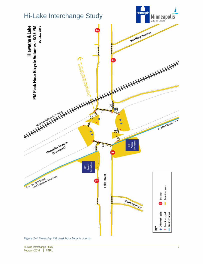
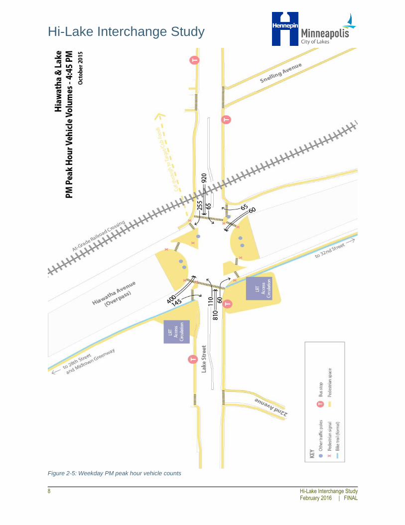
2.3. Demand Passenger vehicle, heavy vehicle, pedestrian, and bicycle counts were taken at the 28th Street, Lake
Street, and 32nd Street intersections along Hiawatha Avenue in October 2015. The counts were
conducted for 24 hours on a weekday and 24 hours on a Saturday. Field visits were also conducted to
document existing conditions. Weekend and weekday totals for each mode can be found in Appendix I.
A summary of peak hour demand for vehicles, pedestrian, and bicycles is provided in Figures 2-3
through 2-5.

Hi-Lake Interchange Study
6 Hi-Lake Interchange Study
February 2016 | FINAL
Figure 2-3: Weekday PM peak hour pedestrian counts
Hi-Lake Interchange Study
Hi-Lake Interchange Study 7 February 2016 | FINAL
Figure 2-4: Weekday PM peak hour bicycle counts
Hi-Lake Interchange Study
8 Hi-Lake Interchange Study
February 2016 | FINAL
Figure 2-5: Weekday PM peak hour vehicle counts

Hi-Lake Interchange Study
Hi-Lake Interchange Study 9 February 2016 | FINAL
Pedestrian Lake Street’s heavy traffic volumes and long crossings with no center median refuge presents
an uninviting pedestrian environment. Perhaps as a result, only around 120 pedestrians were
observed crossing Lake Street at this location in a 24-hour weekday period. By contrast, nearly 2,400
pedestrians crossed east-west within the area over the same weekday time period, traveling to and from
the light rail station and various other destinations in the area.
Bicycle With no specific bicycle facilities within the intersection, many bicycles share the pedestrian
infrastructure. Similar to pedestrians, the east-west movement along Lake Street has higher
volumes than the north-south movements across Lake Street. Around 275 bicycles were observed
crossing Lake Street at this location in a weekday 24-hour period, and over 400 bicycles crossed east-
west within the area over the same weekday time period.
Auto Similar to bicycle and pedestrian movements, the heaviest automobile movement at the Hi-
Lake Interchange is east-west along Lake Street. Over 14,000 automobiles were observed
travelling westbound and nearly 12,000 automobiles were observed travelling eastbound. The
southbound movement from Hiawatha entering Lake Street served nearly 6,000 vehicles. The northbound
movement from Hiawatha to Lake Street was the lowest volume with around 2,300 vehicles observed.
Weekday Daily Total
Direction U Turns Left Turns Straight
Through Right Turns Total
Southbound 0 3,900 0 1,900 5,800
Westbound <10 1,100 9,100 3,800 14,000
Northbound <10 1,000 0 1,300 2,300
Eastbound <50 1,800 8,900 1,000 11,700
33,800
Transit Three bus routes (Route 21, 27, and 53) and one METRO Line (METRO Blue Line) serve the
Hi-Lake Interchange. The eastbound bus stop peaks with over 600 daily alightings and the
westbound bus stop peaks with over 800 boardings. There are approximately 120 daily transfers between
LRT and the WB Route 21 bus. The Lake Street Blue Line Station is one of the busiest METRO stations
outside of a downtown with over 2,600 daily boardings.
Weekday Boardings (Alightings)
Mode Direction AM Peak PM Peak Daily Total
Bus Eastbound 30 (80) 90 (130) 410 (610)
Westbound 50 (60) 210 (100) 840 (400)
Blue Line LRT Northbound/Southbound 170 (*) 380 (*) 2,660 (*)
*LRT alightings not available

Hi-Lake Interchange Study
10 Hi-Lake Interchange Study
February 2016 | FINAL
2.4. Key Issues and Opportunities The Hi-Lake Interchange is clearly a busy intersection for all modes. The existing design creates a few
key issues and opportunities for pedestrians and bicycles in particular.
(1) Lighting The area below the Hiawatha Bridge has insufficient lighting. The lack of natural light is uncomfortable for
pedestrians and diminishes perceived safety and personal security. The contrast in lighting between the
area under the bridge and the street makes visibility difficult when entering and exiting the area under the
bridge.
Figure 2-6: Shadows and lighting contrast under bridge
(2) Vehicle-Routing, Pedestrian Visibility, and Non-Compliance
Pedestrians frequently cross on the Don’t Walk indications when they perceive a gap in traffic. However,
the large intersection makes it difficult for pedestrians to see and recognize the approaching left-turn
vehicles. The Hiawatha bridge over the interchange compounds the issue by blocking natural light and
making the intersection dark.
Figure 2-7: Left-turning vehicles approaching the pedestrian crosswalk
Hi-Lake Interchange Study
Hi-Lake Interchange Study 11 February 2016 | FINAL
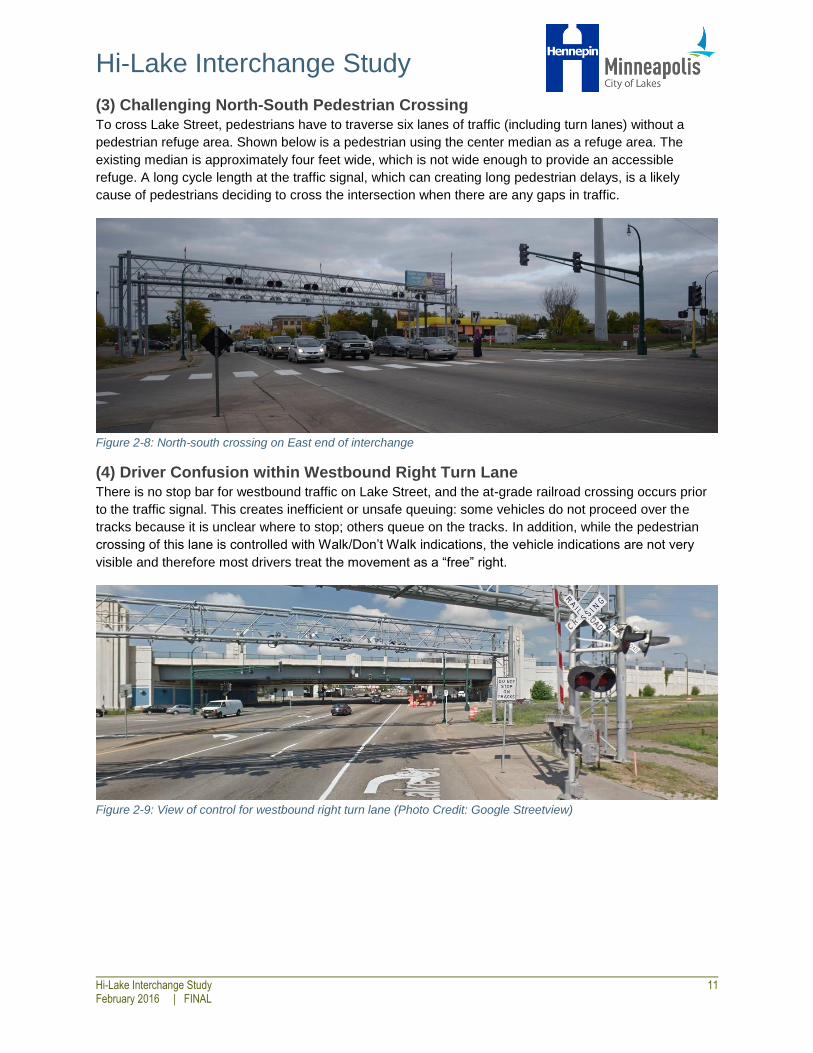
(3) Challenging North-South Pedestrian Crossing To cross Lake Street, pedestrians have to traverse six lanes of traffic (including turn lanes) without a
pedestrian refuge area. Shown below is a pedestrian using the center median as a refuge area. The
existing median is approximately four feet wide, which is not wide enough to provide an accessible
refuge. A long cycle length at the traffic signal, which can creating long pedestrian delays, is a likely
cause of pedestrians deciding to cross the intersection when there are any gaps in traffic.
Figure 2-8: North-south crossing on East end of interchange
(4) Driver Confusion within Westbound Right Turn Lane There is no stop bar for westbound traffic on Lake Street, and the at-grade railroad crossing occurs prior
to the traffic signal. This creates inefficient or unsafe queuing: some vehicles do not proceed over the
tracks because it is unclear where to stop; others queue on the tracks. In addition, while the pedestrian
crossing of this lane is controlled with Walk/Don’t Walk indications, the vehicle indications are not very
visible and therefore most drivers treat the movement as a “free” right.
Figure 2-9: View of control for westbound right turn lane (Photo Credit: Google Streetview)

Hi-Lake Interchange Study
12 Hi-Lake Interchange Study
February 2016 | FINAL
(5) Challenging North-South Bicycle Crossing The intersection is a key midpoint between the Midtown Greenway to the north and the Hiawatha Trail to
the south. With no bicycle-specific infrastructure or right-of-way (and with no through-movements allowed
for vehicles), bicyclists are forced to use pedestrian paths to cross Lake Street.
Figure 2-10: Bicyclist waiting on the island to cross Lake Street
(6) Confusing Bicycle Routing For bicyclists approaching Lake Street from the Midtown Greenway along the west side of Hiawatha
Avenue, it is unclear how to access Lake Street. Some bikes use the narrow, unmarked, and unsigned
shoulder and others use the sidewalk.
Figure 2-11: Southbound approach to Lake Street from bicyclist's perspective

Hi-Lake Interchange Study
Hi-Lake Interchange Study 13 February 2016 | FINAL
(7) Bus Bridge Operations Prior to the installation of pedestrian refuge islands, two signs below the Hiawatha bridge would illuminate
during Blue Line outages to allow buses to make a through movement. With the pedestrian refuge islands
in place, buses cannot make through movements. Instead, southbound bus bridges access the Lake
Street Station by traveling on Cedar Avenue to Lake Street. This creates inefficiencies in the bus
operations.
Figure 2-12: View of bus bridge message sign
(8) Future Plaza Space The Corcoran Parklet on the southwest corner of the intersection is the future site of a permanent one-
acre plaza that will be home to the Midtown Farmers Market. It offers yard furniture and green space in an
otherwise bustling intersection.
Figure 2-13: Corcoran Parklet

Hi-Lake Interchange Study
14 Hi-Lake Interchange Study
February 2016 | FINAL
(10) New and Future Transit-Oriented Development The intersection has a new transit-oriented senior and affordable housing development called the Lake
Street Station apartments. Proximity to transit, Nice Ride, shopping, and restaurants is an integral part of
the building’s marketing. Additionally, Hennepin County is redeveloping the former light rail park and ride
lot on the southwest quadrant of the interchange, and the development will include a Hennepin County
Service Center as well as housing and office space.
Figure 2-14: Lake Street Station Apartments

Hi-Lake Interchange Study
Hi-Lake Interchange Study 15 February 2016 | FINAL
3.0 EVALUATION MEASURES
3.1. Development In order to evaluate the potential improvement alternatives against the existing conditions, several
evaluation measures were generated. These measures, broken into seven categories (Pedestrian,
Bicycle, Vehicles, Transit, Livability & Sustainability, and Costs), attempt to address the issues and
opportunities identified in the existing conditions. The criteria are based on existing conditions and are
generally measurable (e.g. east-west crossing distance), and the goal of each criteria (e.g. to decrease
the east-west crossing distance) was based on the Humanize Hi-Lake petition and the National
Association of City Transportation Officials (NACTO) Urban Street Guide. While the goals of the
evaluation measures lay the foundation for all improvements, they were primarily used to evaluate the
Tier III Alternatives (discussed in Section 6.0) in order to objectively compare the large-scale, long-term
improvements.
3.2. Base Conditions The evaluation measures and the base condition per measure is shown in the table below. A full
description of each measure including the evaluation methodology is provided in Appendix C. Several
measures, identified in italics, would likely not change with geometric improvements, or the impacts
cannot be estimated. For these measures, the existing condition is noted, if available, and the footnote
identifies other measures that partially capture the objective of the measure in some form.
Evaluation Measures for Tier III Improvements
No. Evaluation Measure Notes
Base
Condition
Pedestrians
P1
East-West Crossing
Distance
The distance that a pedestrian on Lake Street is in a
crosswalk 200 feet
P2 East-West Signal Delay The average time a pedestrian waits for a walk signal 56 seconds
P3 East-West Crossing Time
The average time a pedestrian on Lake Street is in a
crosswalk 57 seconds
P4 East-West Total Time
The total time needed to travel from eastbound bus stop
to the railroad crossing on the north side of Lake Street 199 seconds
P5 East-West Lane Crossings
The number of vehicle lanes a pedestrian on Lake Street
crosses 5
P6
Count of Vehicle Free
Rights The number of non-signalized turns allowed 2
P71
Number and severity of
pedestrian crashes
2 pedestrian/vehicle crashes since 2010 (4% of total collisions), both at
crash severity C (possible injury). Full report available.
Bicycles
B1 Bicycle Crossing Distance
Evaluated using pedestrian crosswalk distance across Lake
Street on west side of intersection 140 Feet

Hi-Lake Interchange Study
16 Hi-Lake Interchange Study
February 2016 | FINAL
Evaluation Measures for Tier III Improvements
No. Evaluation Measure Notes
Base
Condition
B2 Average Bicycle Delay
Evaluated using average pedestrian signal delay across
Lake Street on west side of intersection 91 seconds
B3
Opportunity to connect
trails and Blue Line
station
Geometry would allow for bicycle connection between
the Hiawatha Trail extension and LRT station No
B42
Number and severity of
bicycle crashes
2 bicycle/vehicle crashes since 2010 (4% of total collisions), both at crash
severity PDO. Full report available.
B52
Number of people biking
to/from transit
This data was not available from Metro Transit or the counts conducted
for this study
Vehicles
V1
Peak Hour Delay Per
Vehicle Weighted average per vehicle for the entire intersection 35 seconds
V2
Approaches with
Spillback
Total number of approaches with spillback during peak
hour 1
V3 Queue Length Maximum 95th percentile queue length 510 feet
V4 Cut-Through Potential
Likelihood that vehicles will use interchange to avoid
traffic on Hiawatha 0
V5
Maximum
Volume/Capacity Ratio
Maximum value at Lake & Hiawatha during the peak
hour; the threshold is less than one 0.64
V6
Volume/Capacity Ratio
Sensitivity Test
Increase in traffic volumes required to surpass a volume
to capacity ratio of 1 at the intersection 25%
V7.1
Effect on adjacent
intersections: 28th St. Maximum Volume/Capacity ratio at 28th Street 0.95
V7.2
Effect on adjacent
intersections: 32nd St. Maximum Volume/Capacity ratio at 32nd Street 0.90
V83 Prevalence of speeding
Lake Street (West of intersection): 85 percent of vehicles travel at or
below 29-30 MPH in 2010; no data available for ramps
V93
Number and severity of
automobile crashes
50 auto/auto crashes since 2010 (92% of total collisions) with the
majority being rear-ends.
Full report available.
Transit
T1 Bus Movements Allowed
The number of ramps used during “bus bridge”
operations
2 (South
ramps only)
T2
Incorporates arterial BRT
Station Footprint
Whether or not geometry could include a full arterial BRT
station No
T3
Distance between bus
stop and LRT Station
Distance between LRT station and bus stop sign (120 feet
minimum assumed for arterial BRT)
WB: 140 ft.
EB: 50 ft.
T4
Delay due to merging
back into traffic
Number of times the bus experiences delay from merging
back into the travel lane after boarding passengers Multiple

Hi-Lake Interchange Study
Hi-Lake Interchange Study 17 February 2016 | FINAL
Evaluation Measures for Tier III Improvements
No. Evaluation Measure Notes
Base
Condition
Livability and Sustainability
L1 Diverted Vehicles
Number of vehicles from Hiawatha that use other routes
to access Lake Street per day 0
L2
Pavement
Removal/Opportunity
Space Area re-allocated from transportation to other uses 0
L3 Livability Aesthetics
Geometry could decrease areas of shadow, include
additional street lights, or incorporate public art Minimal
L4
Opportunity for Shade &
Trees
Geometry could include new medians with planters,
street trees, and/or boulevards Minimal
L5
Wayfinding (Decrease
Pedestrian Confusion) Geometry is simple and pedestrian space is obvious None
L64
Presence of
garbage/debris Common
L74 Crime rates
Over the past year, 7 incidents of robbery, 1 motor vehicle theft, 1
homicide, and 1 aggravated assault was reported to Minneapolis Police
Department near the intersection
L84
Surveillance/camera
coverage Unknown
Costs
C1 Capital Costs Estimated capital costs (2015 dollars) $0 1 Not carried forward as an evaluation measure. Captured by P1, P5, and P6. 2 Not carried forward as an evaluation measure. Captured by B1, B2, and B3. 3 Not carried forward as an evaluation measure. Captured by P6, V2, V3, and V5. 4 Not carried forward as an evaluation measure. Captured by L3

Hi-Lake Interchange Study
18 Hi-Lake Interchange Study
February 2016 | FINAL
4.0 TIER I IMPROVEMENTS
4.1. Overview As discussed in the Introduction, this study discusses three categories of improvements: Tier I, Tier II,
and Tier III. Tier I improvements are those that are most easily implemented and have the smallest capital
costs. Tier I improvements could occur more quickly, but have a smaller impact in terms of the scale of
the improvements. Tier I improvements include surface level enhancements and no geometric changes.
4.2. Improvement Types Potential Tier I improvements are listed below, categorized by the general goal of the strategy. Each of
these improvements have been shown to improve the pedestrian and bicycle environment and would be
expected to have a minor or negligible impact on average vehicle delays and queue lengths. Locations for
potential implementation of the Tier I improvements are shown in Figure 4-1.

Hi-Lake Interchange Study
Hi-Lake Interchange Study 19 February 2016 | FINAL
Figure 4-1: Potential locations for Tier I Improvements
Hi-Lake Interchange Study
20 Hi-Lake Interchange Study
February 2016 | FINAL
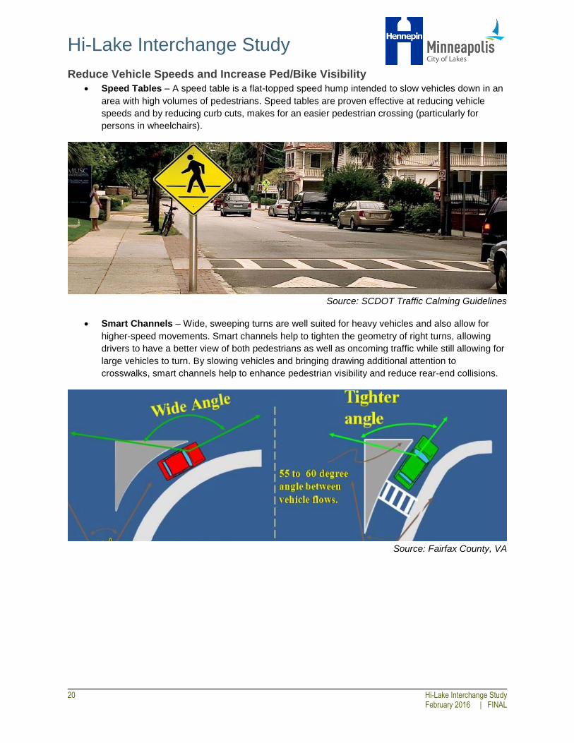
Reduce Vehicle Speeds and Increase Ped/Bike Visibility
Speed Tables – A speed table is a flat-topped speed hump intended to slow vehicles down in an
area with high volumes of pedestrians. Speed tables are proven effective at reducing vehicle
speeds and by reducing curb cuts, makes for an easier pedestrian crossing (particularly for
persons in wheelchairs).
Source: SCDOT Traffic Calming Guidelines
Smart Channels – Wide, sweeping turns are well suited for heavy vehicles and also allow for
higher-speed movements. Smart channels help to tighten the geometry of right turns, allowing
drivers to have a better view of both pedestrians as well as oncoming traffic while still allowing for
large vehicles to turn. By slowing vehicles and bringing drawing additional attention to
crosswalks, smart channels help to enhance pedestrian visibility and reduce rear-end collisions.
Source: Fairfax County, VA
Hi-Lake Interchange Study
Hi-Lake Interchange Study 21 February 2016 | FINAL
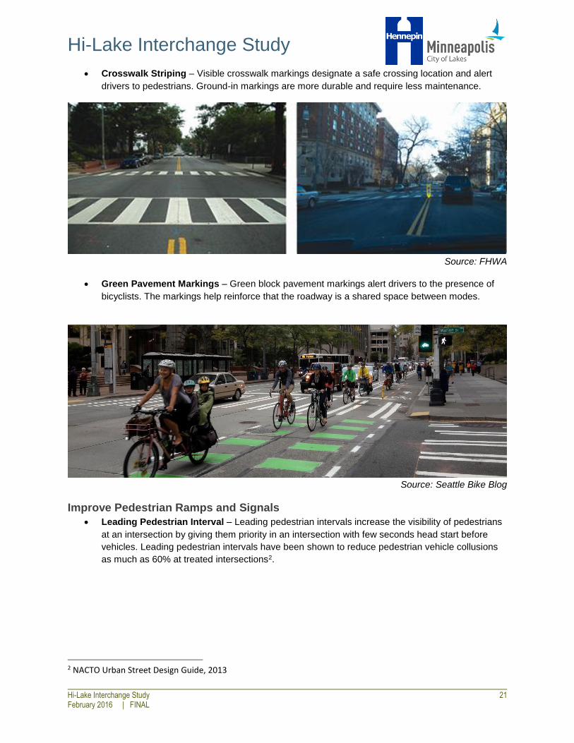
Crosswalk Striping – Visible crosswalk markings designate a safe crossing location and alert
drivers to pedestrians. Ground-in markings are more durable and require less maintenance.
Source: FHWA
Green Pavement Markings – Green block pavement markings alert drivers to the presence of
bicyclists. The markings help reinforce that the roadway is a shared space between modes.
Source: Seattle Bike Blog
Improve Pedestrian Ramps and Signals
Leading Pedestrian Interval – Leading pedestrian intervals increase the visibility of pedestrians
at an intersection by giving them priority in an intersection with few seconds head start before
vehicles. Leading pedestrian intervals have been shown to reduce pedestrian vehicle collusions
as much as 60% at treated intersections2.
2 NACTO Urban Street Design Guide, 2013

Hi-Lake Interchange Study
22 Hi-Lake Interchange Study
February 2016 | FINAL
Source: NACTO
Reconstruct Pedestrian Ramps – reconstructing the pedestrian ramps of the interchange will
bring the area up to Americans with Disabilities (ADA) standards. New detectable warning
surfaces and reconfigured slopes will make the area more easily traveled for all users. All 16
ramps were assumed to be reconstructed.
Source: FHWA
Accessible Pedestrian Signal (APS) Push Buttons – APS push
buttons provide audible information to blind or visibility impaired
pedestrians that correspond to the display of the pedestrian indications
at the intersection. The audible sounds help the pedestrian navigate to
the push button and indicates the status of the pedestrian indication, as
well as the name of the street and/or intersection to be crossed.
Source: Minneapolis
Pedestrian Master Plan

Hi-Lake Interchange Study
Hi-Lake Interchange Study 23 February 2016 | FINAL
Pedestrian Countdown Timers – APS
pushbuttons are typically installed in conjunction
with pedestrian countdown timers, which help to
inform pedestrians of the amount of time remaining
to cross the street. Countdown timers give
pedestrians more knowledge of their available
crossing time, allowing them to make a more
informed decision regarding whether it is safe to
cross. Some signal heads with countdown timers
are already installed at the interchange, but did not
appear to be functioning correctly during the field
observations. If installed in conjunction with APS
improvements, combined APS/countdown timers
would allow for an audible message of the
available remaining crossing time.
Improve Pedestrian/Bicycle Comfort and Sense of Security
Lighting Improvements – Lighting plays a large role in how safe a pedestrian feels. Lighting will
also improve pedestrian/bicycle visibility.
Street Trees – Street trees and other street-adjacent elements can slow traffic down while
enhancing the overall pedestrian environment.
Source: FHWA
Source: Minneapolis Pedestrian Master
Plan
Hi-Lake Interchange Study
24 Hi-Lake Interchange Study
February 2016 | FINAL
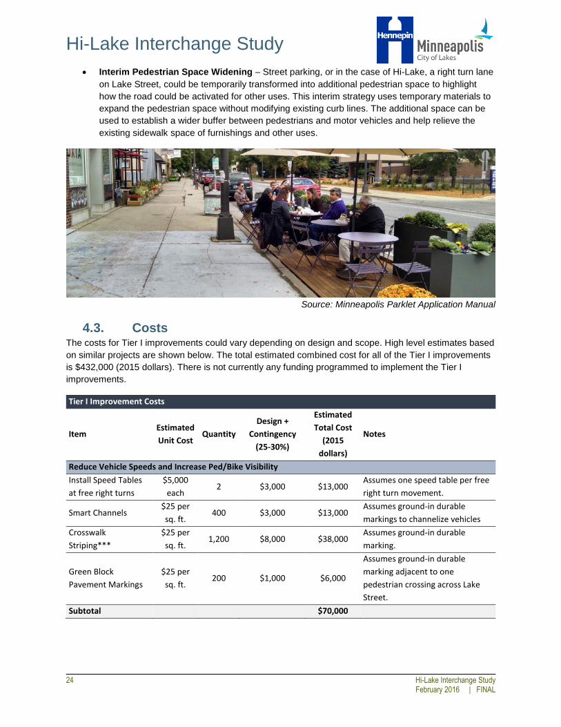
Interim Pedestrian Space Widening – Street parking, or in the case of Hi-Lake, a right turn lane
on Lake Street, could be temporarily transformed into additional pedestrian space to highlight
how the road could be activated for other uses. This interim strategy uses temporary materials to
expand the pedestrian space without modifying existing curb lines. The additional space can be
used to establish a wider buffer between pedestrians and motor vehicles and help relieve the
existing sidewalk space of furnishings and other uses.
Source: Minneapolis Parklet Application Manual
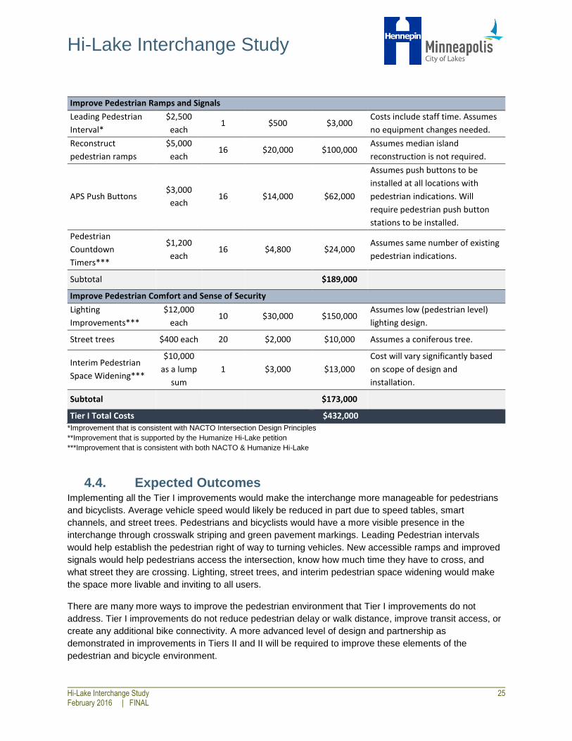
4.3. Costs The costs for Tier I improvements could vary depending on design and scope. High level estimates based
on similar projects are shown below. The total estimated combined cost for all of the Tier I improvements
is $432,000 (2015 dollars). There is not currently any funding programmed to implement the Tier I
improvements.
Tier I Improvement Costs
Item Estimated
Unit Cost Quantity
Design +
Contingency
(25-30%)
Estimated
Total Cost
(2015
dollars)
Notes
Reduce Vehicle Speeds and Increase Ped/Bike Visibility
Install Speed Tables
at free right turns
$5,000
each 2 $3,000 $13,000
Assumes one speed table per free
right turn movement.
Smart Channels $25 per
sq. ft. 400 $3,000 $13,000
Assumes ground-in durable
markings to channelize vehicles
Crosswalk
Striping***
$25 per
sq. ft. 1,200 $8,000 $38,000
Assumes ground-in durable
marking.
Green Block
Pavement Markings
$25 per
sq. ft. 200 $1,000 $6,000
Assumes ground-in durable
marking adjacent to one
pedestrian crossing across Lake
Street.
Subtotal $70,000
Hi-Lake Interchange Study
Hi-Lake Interchange Study 25 February 2016 | FINAL
*Improvement that is consistent with NACTO Intersection Design Principles
**Improvement that is supported by the Humanize Hi-Lake petition
***Improvement that is consistent with both NACTO & Humanize Hi-Lake
4.4. Expected Outcomes Implementing all the Tier I improvements would make the interchange more manageable for pedestrians
and bicyclists. Average vehicle speed would likely be reduced in part due to speed tables, smart
channels, and street trees. Pedestrians and bicyclists would have a more visible presence in the
interchange through crosswalk striping and green pavement markings. Leading Pedestrian intervals
would help establish the pedestrian right of way to turning vehicles. New accessible ramps and improved
signals would help pedestrians access the intersection, know how much time they have to cross, and
what street they are crossing. Lighting, street trees, and interim pedestrian space widening would make
the space more livable and inviting to all users.
There are many more ways to improve the pedestrian environment that Tier I improvements do not
address. Tier I improvements do not reduce pedestrian delay or walk distance, improve transit access, or
create any additional bike connectivity. A more advanced level of design and partnership as
demonstrated in improvements in Tiers II and II will be required to improve these elements of the
pedestrian and bicycle environment.
Improve Pedestrian Ramps and Signals
Leading Pedestrian
Interval*
$2,500
each 1 $500 $3,000
Costs include staff time. Assumes
no equipment changes needed.
Reconstruct
pedestrian ramps
$5,000
each 16 $20,000 $100,000
Assumes median island
reconstruction is not required.
APS Push Buttons $3,000
each 16 $14,000 $62,000
Assumes push buttons to be
installed at all locations with
pedestrian indications. Will
require pedestrian push button
stations to be installed.
Pedestrian
Countdown
Timers***
$1,200
each 16 $4,800 $24,000
Assumes same number of existing
pedestrian indications.
Subtotal $189,000
Improve Pedestrian Comfort and Sense of Security
Lighting
Improvements***
$12,000
each 10 $30,000 $150,000
Assumes low (pedestrian level)
lighting design.
Street trees $400 each 20 $2,000 $10,000 Assumes a coniferous tree.
Interim Pedestrian
Space Widening***
$10,000
as a lump
sum
1 $3,000 $13,000
Cost will vary significantly based
on scope of design and
installation.
Subtotal $173,000
Tier I Total Costs $432,000

Hi-Lake Interchange Study
26 Hi-Lake Interchange Study
February 2016 | FINAL
5.0 TIER II IMPROVEMENTS
5.1. Overview Tier II improvements include modest geometric modifications within the existing vehicle right-of-way to
reclaim space for pedestrians, bicycles, and transit infrastructure. While these improvements would not
significantly modify the geometry of the existing interchange, they could serve as an initial phase prior to
a more major infrastructure project. Locations for the proposed Tier II improvements are shown in Figure
5-1.
Figure 5-1: Potential locations for Tier II Improvements

Hi-Lake Interchange Study
Hi-Lake Interchange Study 27 February 2016 | FINAL
5.2. Improvement Options
(1) Westbound Right Turn Lane Removal at Lake Street & 22nd Avenue
The westbound approach to 22nd Avenue on Lake Street includes two through lanes, a 150-foot left turn
lane (including taper), and a 250-foot right turn lane (including taper). In general, right turn lanes are very
uncommon on Lake Street, and most cross sections in this area have on-street parking with a curb
extension at the intersection instead of a right turn lane. By removing the right turn lane and extending the
curb to the edge of the current through lane, this improvement would create a wider sidewalk and
boulevard space (approximately 20 feet), allowing for additional streetscape enhancements such as
lighting and landscaping. Additionally, the modification would allow the westbound bus stop to be moved
closer to the LRT station, provide sufficient space for a future arterial BRT station, and would eliminate
the need for buses to pull out of traffic and merge back into the through lane after picking up and dropping
off passengers, improving transit reliability.
As shown on the right, the traffic impacts at the Lake Street/22nd
Avenue intersection associated with the modification would be
minimal, with no significant increases in queuing or delay
expected for the through movement even in peak hours. Even if
right-turn volumes were to double, a shared through/right lane
would be expected to continue to operate acceptably. A planning-
level capacity analysis completed at Hiawatha Avenue/Lake
Street for this study indicated that westbound local bus routes
stopping in the through lane may have some effect on
intersection operations in the PM peak hour, which should be
analyzed further in the design phase of this improvement or the arterial BRT project.
Although the improvement does not directly impact pedestrians and bicyclists at the Hi-Lake interchange,
the transit and pedestrian benefits help to address neighborhood desires for the area.
Key Benefits
Enhanced pedestrian space
Reduced north-south pedestrian crossing distance at Lake Street and 22nd Avenue
Opportunities for streetscape improvement
Opportunities for transit station enhancements
Improved transit reliability
Potential Impacts
Increased vehicle delay during passenger pick-up/drop-off at the bus stop
Construction impacts
Weekday PM Peak Hour
Traffic Impacts
RT Demand: 110 veh./hr.
Queue Increase: +10 feet
Delay Increase: Negligible
Volume/Capacity: < 0.40

Hi-Lake Interchange Study
28 Hi-Lake Interchange Study
February 2016 | FINAL
Figure 5-2: View of westbound right turn lane at 22nd Avenue
(2) Eastbound Right Turn Lane Removal at Lake Street & Southbound Hiawatha
Avenue Entry Ramp The eastbound approach on Lake Street at Hiawatha Avenue includes two through lanes, a 300-foot left
turn lane (including taper), and a 350-foot right turn lane (including taper). As discussed above, right turn
lanes are very uncommon on Lake Street, and this particular right
lane serves only 60 vehicles during the weekday PM peak hour.
By removing the right turn lane and extending the curb to the
edge of the existing through lane, additional space could be
reclaimed for pedestrians around a heavily used bus stop and
light rail station, while also slowing vehicles and shortening the
north-south crossing distance. Additionally, the modification would
allow the eastbound bus stop to be moved closer to the LRT
station, provide sufficient space for a future arterial BRT station,
and would eliminate the need for buses to pull out of traffic and
merge back into the through lane after picking up and dropping off
passengers, improving transit reliability.
The traffic impacts associated with the modification would be minimal, with no significant increases in
queuing or delay in the peak hours under current volumes. Development in the area is expected to
increase peak hour demand on the eastbound approach by 140 vehicles by 2025, of which 20 vehicles
would make the right-turn. Under these conditions, a shared through/right lane would be expected to
continue to operate acceptably. If traffic demands increased more than expected, eastbound queues
could extend back to the 22nd Avenue intersection during limited periods in the PM peak hour. A capacity
level analysis completed for the bus operations showed that eastbound local buses stopping in the
through lane would not be expected to have a significant impact on vehicle delays. However, this should
be analyzed further in the design phase of the arterial BRT or Hi-Lake projects.
Key Benefits
Enhanced pedestrian space
Reduced north-south pedestrian crossing distance
Reduced vehicle speeds
Opportunities for streetscape improvement
Opportunities for transit station enhancements
Improved transit reliability
Weekday PM Peak Hour
Traffic Impacts
RT Demand: 60 veh./hr.
Queue Increase: Negligible
Delay Increase: Negligible
Volume/Capacity: ≈ 0.60

Hi-Lake Interchange Study
Hi-Lake Interchange Study 29 February 2016 | FINAL
Potential Impacts
Increased vehicle delay during passenger pick-up/drop-off at the bus stop
Potential for queue spillback during peak hours if traffic demand increases by more than
projections
Construction impacts
Figure 5-3: View of eastbound right turn lane at Hiawatha Avenue
(3) Northbound Left Turn Lane Removal at Lake Street & Northbound Hiawatha
Avenue Exit Ramp
The northbound approach to Lake Street from Hiawatha Avenue includes two left turn lanes and a right
turn lane, widening from a single exit lane to the three lanes at approximately 350 feet upstream of the
Lake Street intersection. This geometry is very similar to the southbound approach to Lake Street even
though vehicle demands are less than 25 percent of the southbound approach during the PM peak hour.
Because the approach lanes provide significantly more capacity compared to actual vehicle traffic
demand, the west curb could be relocated to remove one of two northbound left turn lanes without
impacting traffic operations. This improvement would reclaim space for pedestrians on the east end of the
interchange and reduce the east-west crossing distance within the roadway.
As shown on the right, the traffic impacts associated with the
modification would be minimal, with no significant increases in
delay expected for the movement in the current weekday PM
peak hour. The queues on the ramp would increase simply
because all vehicles would be in one lane, but would not have
any impacts on mainline Hiawatha Avenue. Development in the
area is expected to increase demand for the left-turn movement
by up to 20 peak hour vehicles by 2025. The approach is
currently operating well under capacity, however, and even if
demands double the approach would continue to operate
acceptably.
Weekday PM Peak Hour
Traffic Impacts
LT Demand: 60 veh./hr.
Queue Increase: +50 feet
Delay Increase: Negligible
Volume/Capacity: < 0.30

Hi-Lake Interchange Study
30 Hi-Lake Interchange Study
February 2016 | FINAL
Figure 5-4: View of double northbound left turn lane from Hiawatha Avenue to Lake Street
Key Benefits
Enhanced pedestrian space
Reduced east-west pedestrian crossing distance in roadway
Reduced vehicle speeds
Opportunities for streetscape improvement
Potential Impacts
Construction impacts
(4) Southbound Right Turn Lane Reduction at Lake Street & Southbound
Hiawatha Avenue Exit Ramp The southbound approach to Lake Street from Hiawatha Avenue includes two left turn lanes and a right
turn lane, widening from a single exit lane to the three turn lanes at approximately 500 feet upstream of
the Lake Street intersection. With vehicle traffic demands of around 400 left-turns and 150 right-turns
during the PM peak hour, the dual-left turn lanes should be preserved to prevent potential queue spillback
under future growth in traffic volumes. However, the extended right turn lane is provided primarily to allow
right turning vehicles to bypass queues from the left turn lanes, which is only a potential issue during peak
periods. By relocating the west curb line and removing the right turn lane until just upstream of the
channelizing island, additional space could be reclaimed for pedestrians around a heavily used light rail
station, while also slowing vehicles and providing additional space for an improved biking route from the
Midtown Greenway. If a mountable curb is installed as part of the curb modification, Metro Transit could
also potentially utilize the space as a temporary bus stop during ‘bus bridge’ operations.
As shown on the right, the traffic impacts associated with the
modification are expected to be minimal. It should be noted that the
high-level capacity analysis conducted does not fully capture the
impacts associated with turn lane blockage, and the results shown
may underestimate the actual impacts. A more detailed microscopic
analysis should be used to estimate the impacts with greater
reliability. However, the average delay for the left turn movement is
estimated to be approximately 50 seconds, so even if right-turn
vehicles had the same delay as the left-turning vehicles, these delays
would still be considered acceptable during peak hours. Development
Weekday PM Peak Hour
Traffic Impacts
RT Demand: 145 veh./hr.
Queue Increase: +40 feet
Delay Increase: +2 s
Volume/Capacity: < 0.30

Hi-Lake Interchange Study
Hi-Lake Interchange Study 31 February 2016 | FINAL
in the area is expected to increase PM peak hour demand for the right-turn movement by up to 30
vehicles by 2025. However, even if right-turn demands double compared to projections, the approach
would be expected to operate acceptably.
Key Benefits
Enhanced pedestrian space
Reduced vehicle speeds
Opportunities for streetscape improvement
Opportunities for improvements to bus bridge operations
Opportunities for bicycle connection improvements
Potential Impacts
Additional right turn delay and potential driver frustration
Construction impacts
Figure 5-5: View of southbound right turn lane from Hiawatha Avenue
5.3. Costs High level estimates for the Tier II improvements based on similar projects and preliminary design
concepts are shown below. The total estimated combined cost for all of the Tier II improvements is
$660,000. There is not currently any funding programmed to implement the Tier II improvements.
Tier II Improvement Costs
Item Estimated
Cost
Indirect Costs
(25%)
Construction
Contingency (20%)
Estimated
Total Cost
(2015
Dollars)
Westbound Right Turn Lane Removal at
22nd Avenue $120,000 $36,000 $24,000 $180,000
Eastbound Right Turn Lane Removal at
Hiawatha Avenue $170,000 $51,000 $34,000 $255,000
Northbound Left Turn Lane Removal at
Lake Street $70,000 $21,000 $14,000 $105,000
Southbound Right Turn Lane Reduction at
Lake Street $80,000 $24,000 $16,000 $120,000
Subtotal $660,000
Hi-Lake Interchange Study
32 Hi-Lake Interchange Study
February 2016 | FINAL
5.4. Expected Outcomes Implementing all the Tier II improvements would improve the pedestrian and bicycle environment and
allow for improved transit operations and station area amenities. Average vehicle speed would likely be
reduced, and crosswalk distances would be reduced. Additionally, more space would be allocated to the
pedestrian and bicycle realm, allowing for potential investments in streetscaping enhancements.
Despite these benefits, not all neighborhood goals would be addressed with these improvements. While
bicycle improvements could be made on the southbound approach, the existing islands would prevent
bicycle north-south through movements on the west side of the intersection. While some crossing
distances would be reduced, overall pedestrian delay would remain largely unchanged as the general
footprint of the interchange and the traffic operations would not change significantly. Addressing more
neighborhood goals for the area would require significant interchange modifications, as discussed in the
Tier III improvements.
Hi-Lake Interchange Study
Hi-Lake Interchange Study 33 February 2016 | FINAL
6.0 TIER III IMPROVEMENTS
6.1. Overview Tier III improvements incorporate many of the Tier I and Tier II improvements, but advance the concepts
further by reconfiguring the basic geometrics of the interchange. These improvements have the greatest
potential to address the pedestrian and bicycle goals for the area, but come at the highest cost and
therefore would take longer to achieve consensus and obtain funding.
Five concept alternatives were developed in the Tier III category. These alternatives were compared
against a no-build alternative (existing condition) using the evaluation measures discussed in section 3.0.
The alternatives were developed at a conceptual level only, so many of the design details would need to
be further developed through engineering design and public input. In addition, each of the alternatives
has both benefits and impacts that necessitate input from stakeholders and the public. Therefore, the key
features and technical merits of each alternative are presented along with potential benefits and impacts,
and no preferred alternative has been identified. Refer to Appendix A to see the conceptual drawings of
the Tier III improvements and Appendix B for a detailed evaluation matrix that includes quantitative
results for all evaluation measures.
An engineer’s opinion of probable cost is presented along with each alternative. The costs include a 25
percent allocation for indirect costs as well as a 20 percent construction contingency, which are
necessary at this stage due to the conceptual level of the engineering at this stage of the project
development. The cost listed includes many of the items described in both Tier I and Tier II, including
lighting improvements, street trees, APS pushbuttons, pedestrian ramp reconstruction, crosswalk
markings, and turn lane removals. The total cost of the Tier III improvements could potentially be reduced
if some of these items were implemented in an earlier phase (e.g., turn lane removals). However, some of
the Tier I improvements such as pedestrian ramps would need to be redone along with the full
intersection reconstruction. It should also be noted that the feasibility of lower cost construction
techniques such as pavement mill and overlay, instead of pavement reconstruction, were not able to be
assessed at this stage. Detailed survey and engineering would be needed to determine if and how the
cost of the improvements could be reduced.

Hi-Lake Interchange Study
34 Hi-Lake Interchange Study
February 2016 | FINAL
6.2. Modified SPUI
Geometric Changes
The modified SPUI reduces the northbound exit ramp to a single lane (from 3 lanes) and reduces the
southbound exit ramp to 2 lanes (from 3 lanes). In addition, the eastbound right-turn lane at Hiawatha
Avenue and the westbound right-turn lane at 22nd Avenue are eliminated. The modifications are similar to
a full implementation of several Tier I and all Tier II improvements, with additional island and geometric
modifications.
Pedestrian and Bicycle Improvements Pedestrians realize the most benefit on the south side of Lake Street with this alternative. A slightly
reduced crossing distance and reduced average travel time occurs when pedestrians use the south side
of Lake Street to travel east-west through the interchange. However, there is still not sufficient space for a
bicycle connection across the interchange to be provided. On the north side, pedestrians and bicyclists
would experience longer average delays due to the increased percentage of time needed to serve
vehicles on the southbound approach. In addition, the free right-turns from Hiawatha Avenue to Lake
Street would still exist.
Transit Improvements As discussed in the Tier II improvements, removing the right turn lanes on the west side of the
interchange would allow more space for transit station amenities and allow buses to stop within the travel
lane instead of having to pull out and merge back into traffic. However, the islands at the interchange
would not allow for any improved bus bridge operations.
Figure 6-1: Tier III Alternative 1 (Modified SPUI)

Hi-Lake Interchange Study
Hi-Lake Interchange Study 35 February 2016 | FINAL
Traffic Impacts With the various geometric modifications on the northbound and southbound approaches, these
approaches would require additional green time to clear peak hour vehicle queues. This reallocation of
green time to the side street approaches would have the effect of adding some east-west pedestrian
delay during peak hours. Vehicle traffic would continue to operate acceptably, but with increased delays
and increased volume to capacity (v/c) ratios, limiting the overall amount of traffic growth that could be
accommodated in the area.
Because the northbound left turn movement volumes are relatively low and can likely be accommodated
by a single lane, MnDOT indicated support for a single northbound left turn lane.
A sub-alternative was analyzed with a single southbound left turn lane, and the results are provided in
Appendix D. However, because of the large volumes in this movement, this single southbound left turn
lane would lead to queues of approximately 500 feet during peak hours, and volumes would begin to
reach capacity with anticipated growth in the area. During the study process MnDOT indicated that any
alternative which impacts the number of left turn lanes or left-turn storage capacity such that ramp traffic
queues onto mainline Hiawatha is unacceptable and would not be supported. Therefore a conceptual
layout was not developed for this sub-alternative.
Key Benefits
Reclaimed pedestrian space
Reduced pedestrian/bicycle crossing distances
Reduced vehicle speeds
Opportunities for streetscape improvements
Opportunities for transit station enhancements
Improved transit reliability
Key Issues
3 of 4 islands remain
Straightening of the east-west crossing would result in additional exposure to vehicles
Increased east-west pedestrian delay
Increase in vehicle delays, queuing, and v/c ratios
No improvement to bus bridge operations
Cost
$2,415,000 (2015 dollars)

Hi-Lake Interchange Study
36 Hi-Lake Interchange Study
February 2016 | FINAL
6.3. Tight Diamond
Geometric Changes The Tight Diamond alternative converts the SPUI to a diamond interchange (Figure 6-2). This allows the
northbound exit ramp to be reduced to a single lane and the southbound exit to two lanes. The right-turn
lanes eastbound at Hiawatha Avenue and westbound at 22nd Street were removed, similar to the Modified
SPUI. The westbound right-turn lane at Hiawatha Avenue was also removed in this alternative. The space
under the bridge is limited, so the eastbound and westbound left-turn lanes to the Hiawatha Avenue
ramps would need to be side-by-side without a median.
Figure 6-2: Tier III Alternative 2 (Tight Diamond)
The signals at the two ramp intersections would need to be controlled with one signal controller in order to
minimize any vehicle queuing on Lake Street between the ramps. Due to the angle of the ramp
intersections and the need to accommodate truck turning movements, the intersection radii are still
somewhat large. The details of the intersection corners in terms of radii and pedestrian ramps would need
to be explored further if the alternative were to move into final design.
A sub-alternative was also explored that connects the ramps at an angle closer to 90 degrees (Figure 6-
3, next page). This would create an offset between the entrance and exit ramps, which would discourage
cut-through traffic. Articulated buses can make it through the intersection in this revised alternative.

Hi-Lake Interchange Study
Hi-Lake Interchange Study 37 February 2016 | FINAL
Figure 6-3: Tier III Sub-Alternative 2 (90-Degree Tight Diamond)
Pedestrian and Bicycle Improvements
The Tight Diamond alternative allows the pedestrian/bicycle crossings of the ramps to be shortened
significantly, the pedestrian/bicycle routes to be direct, and there would be space for a dedicated east-
west bicycle connection on the south side of the intersection. The crossings would be simplified, and
median refuge could be provided for the crossings of Lake Street. All pedestrian evaluation measures are
improved compared to the base condition. The removal of the islands would also allow for a southbound
bicycle through movement. As with the Modified SPUI, this alternative would reclaim space for
pedestrians, but an additional full lane in the northeast quadrant could also be reallocated to pedestrian
space.
Transit Improvements
All benefits identified in the Tier II improvements would be maintained, and the elimination of the islands
would allow for full use of all four ramps during bus bridge operations.
Traffic Impacts
The Tight Diamond design would generally maintain or improve traffic operations due to the flexibility in
left-turn phasing on Lake Street, the reduced yellow and all red times at the intersection, and the
opportunity to shorten the green time on the northbound approach. If the current peak hour turning
movement percentages continued, this interchange design could accommodate more overall growth than
the baseline condition. Due to the short distance between intersections, some queuing between the two
ramp intersections would be expected, but this could be minimized through optimized signal coordination.
With the elimination of the islands, no physical barrier would prevent vehicles from using the interchange

Hi-Lake Interchange Study
38 Hi-Lake Interchange Study
February 2016 | FINAL
to bypass congestion on Hiawatha Avenue, unless the 90 degree interchange sub-alternative were
chosen.
Because the northbound left turn movement volumes are relatively low and can likely be accommodated
by a single lane, MnDOT indicated support for a single northbound left turn lane.
As within the Modified SPUI, a sub-alternative was analyzed with a single southbound left turn lane, and
the results are provided in Appendix D. However, because of the large volumes in this movement, this
single southbound left turn lane would lead to queues of approximately 600 feet during peak hours with
volumes nearing capacity under existing volumes. During the study process MnDOT indicated that any
alternative which reduces the number of left turn lanes on this approach would not be supported due to
the high demands and concern over queue spillback onto mainline Hiawatha with increased volumes.
Therefore a conceptual layout was not developed for this sub-alternative.
Key Benefits
Reclaimed pedestrian space
Reduced pedestrian/bicycle crossing distances
Potential for improved bicycle connection to the LRT station
Potential for median refuge crossing Lake Street
More direct pedestrian routing
Reduced vehicle speeds
Opportunities for streetscape improvements
Opportunities for transit station enhancements
Improved transit reliability
Improved bus bridge operations
Key Issues
Increased potential for cut-through traffic from Hiawatha
Cost
$4,005,000 (2015 dollars)

Hi-Lake Interchange Study
Hi-Lake Interchange Study 39 February 2016 | FINAL
6.4. Half-Diamond with Promenade
Geometric Changes
The Half-Diamond alternative includes the same improvements as the Tight Diamond alternative, but
removes both ramps on the south side of the interchange (Figure 6-4). These ramps were identified to be
removed because the daily traffic volumes are relatively low (2,000-2,500 vehicles per day) compared to
the ramps on the north side which carry 5,000-6,000 vehicles per day. By eliminating the ramps on the
south side, a very wide pedestrian and bicycle space could be created. This would provide a dedicated
pedestrian space with no vehicle conflicts and allow for a separate dedicated bicycle space between the
two north-south bike facilities.
Figure 6-4: Tier III Alternative 3 (Half-Diamond with Promenade)
Although the signal on the east side of the interchange could feasibly be eliminated based on traffic
operations, the alternative maintains two signals in order to provide a signalized north-south pedestrian
crossing on the east side of the interchange.
Pedestrian and Bicycle Improvements
The Half-Diamond alternative allows the pedestrian/bicycle crossings of the ramps to be shortened
significantly, with the added benefit of eliminating east-west crossings altogether on the south side of the
interchange, and the pedestrian/bicycle routes would be more direct than in the base condition. The
space gained from the ramp removals on the south side of the interchange could be enhanced in a
variety of ways. Overall, all pedestrian evaluation measures are improved with the alternative, and the
removal of the islands would also allow for a southbound bicycle through movement on the west side of
the interchange.
Hi-Lake Interchange Study
40 Hi-Lake Interchange Study
February 2016 | FINAL
Transit Improvements All benefits identified in the Tier II improvements would be maintained. However, the elimination of the
south legs of the interchange would require alternative routing during bus bridge operations, degrading
transit reliability during these times. Additionally, when the freight rail crossing is blocked, eastbound
transit vehicles would no longer have the option to use the south ramps to bypass the blockage.
Traffic Impacts
The Half-Diamond design would generally maintain or improve traffic operations at the interchange,
primarily due to the elimination of several vehicle movements. If the current turning movement
percentages continued, this design could accommodate more overall growth than the baseline condition
or any other alternative. Due to the short distance between intersections, some queue spillback between
the two ramp intersections would be expected, but this could be minimized through optimized signal
coordination.
In order to serve the heavy southbound left turn demand, the Half-Diamond with Promenade includes two
southbound left turn lanes. On the northbound approach, however, a single left turn lane is sufficient to
serve the relatively low volumes during peak hours. Upon review of the traffic analysis, MnDOT confirmed
this approach and indicated a left turn lane reduction would be acceptable on the northbound approach
but not on the southbound approach..
The elimination of the south legs of the interchange would divert approximately 4,400 vehicles per day to
other roadways, likely along north-south local streets such as Minnehaha Avenue or 22nd Avenue. This
would increase the left turn demand at 32nd Street and Hiawatha Avenue, causing the peak movement to
operate near or at capacity. For the screening level of analysis conducted in this study, traffic operations
on the surrounding roadway network and the traffic/LRT interactions at Hiawatha Avenue/32nd Street
were not analyzed in detail. MnDOT expressed concern that eliminating any existing ramps at the
intersection will cause greater than anticipated operational impacts at 32nd Street (and potentially 28th
Street), compounded by impacts associated with LRT operations and uncertain diversion rates.
Key Benefits
Reclaimed pedestrian space
Reduced pedestrian/bicycle crossing distances and potential for median refuge on Lake Street
Potential for improved bicycle connection to the LRT station
More direct pedestrian routing
Reduced vehicle speeds
Opportunities for streetscape improvements
Opportunities for transit station enhancements
Improved transit reliability (during normal operations)
Elimination of two roadway crossings on the south side of the interchange
Key Issues
Degraded bus bridge operations
Elimination of potential escape route for eastbound buses during railroad crossing events
Increased vehicle diversion through neighborhoods
Increased vehicle delays and v/c ratios at 32nd Street and Hiawatha Avenue, and uncertainty regarding potential operational impacts due to estimated diversion rates and LRT operations
Cost
$4,650,000 (2015 dollars)

Hi-Lake Interchange Study
Hi-Lake Interchange Study 41 February 2016 | FINAL
6.5. Two-Way Ramps
Geometric Changes
The Two-Way Ramps alternative includes the same right-turn removals as noted in the Tight Diamond
alternative. However, both exit ramps from Hiawatha Avenue are removed and the entrance ramps are
converted to two-way roadways (Figure 6-5). This would require drivers to use the intersections at
Hiawatha Avenue & 28th Street and Hiawatha Avenue & 32nd Street to access the two-way ramps. For
southbound traffic at 28th Street, there is not space to create a left-turn lane due to the LRT bridge pier,
and therefore a through lane would need to be converted to a left-turn lane to provide for the movement
to the two-way ramp. In addition, the existing northbound left-turn movement from the ramp to 28th Street
would need to be eliminated. At 32nd Street, a northbound left-turn lane already exists so only the island in
the northwest quadrant would need to be modified. It was assumed that the southbound left-turn
movement from the ramp and the southbound right-turn movement from Hiawatha Avenue would
continue to be restricted, as in the base conditions. It was noted during the evaluation of this alternative
that the movements from Hiawatha Avenue onto the two-way ramps would not be intuitive to drivers and
would have both safety and operational concerns. This is a very unusual intersection type and would
have safety and operational concerns for all modes.
Figure 6-5: Tier III Alternative 4 (Two-Way Ramps)
Pedestrian and Bicycle Improvements The Two-Way Ramps alternative allows the pedestrian/bicycle crossings of the ramps at Hiawatha/Lake
to be shortened significantly, with the added benefit of eliminating two east-west roadway crossings
altogether on the northwest and southeast sides of the interchange. This space could be enhanced in a

Hi-Lake Interchange Study
42 Hi-Lake Interchange Study
February 2016 | FINAL
variety of ways. Overall, all pedestrian evaluation measures are improved with the alternative, and the
removal of the islands would also allow for a southbound bicycle through movement.
At 32nd Street, the roadway crossing would be lengthened to accommodate the additional vehicle lane. At
both 28th Street and 32nd Street, the pedestrian and bicycle crossings would be complicated as there
would be added conflicts and more vehicle traffic.
Transit Improvements All benefits identified in the Tier II improvements would be maintained. The alternative could potentially
improve bus bridge operations compared to the base conditions, but would require buses to stop on the
southbound approach to the intersection to pick up and drop off passengers at a temporary stop.
Traffic Impacts The Two-Way Ramps design would generally maintain or improve traffic operations at the Hi-Lake
interchange. However, due to the capacity constraints of a single southbound left-turn exit lane, some
vehicle diversion would be expected; this was estimated to be around 2,100 vehicles per day. These
vehicles would be expected to instead exit southbound Hiawatha at 26th Street or choose another route,
rather than attempt to turn left at 28th Street to access Lake Street. Although the impacts to 26th Street
were not analyzed, this is a congested, constrained intersection that is preempted by LRT, and adding left
turning volume to this intersection would likely degrade operations, potentially to unacceptable levels, and
therefore require improvements.
At 28th Street, a southbound through lane would need to be restriped to a left turn lane due to the bridge
supports in the median, a new left turn phase would need to be added, and the left turning movement
from the ramp to 28th Street (less than 20 vehicles during the PM peak hour) would need to be eliminated
in order to accommodate this new phase. Even with optimized phasing and assumed vehicle diversion,
the southbound left turn lane demand would exceed capacity.
At 32nd Street, signs would need to be installed to direct drivers to the northbound left turn lane for
vehicles headed to 32nd Street as well as to Lake Street. Although no new phases would need to be
added to allow two-way operations on the Lake Street access segment, additional delay and queuing
would be expected. At the screening level of analysis conducted, light rail operational impacts on vehicle
traffic are not captured, and therefore vehicle delays may be greater than reported.
Given the proposed single southbound left turn lane at Lake Street and the geometrics and operations at
28th Street and 32nd Street, compounded by light rail operations and uncertainty regarding potential
diversion rates, MnDOT does not support the Two-Way Ramp concept as proposed. As noted previously,
MnDOT expressed significant concerns with any concept that includes a southbound left turn lane
reduction or eliminates existing ramps from the Lake Street interchange due to the potential operational
impacts on Hiawatha Avenue.
Key Benefits
Reclaimed pedestrian space
Reduced pedestrian/bicycle crossing distances
Potential for improved bicycle connection to the LRT station
Potential for median refuge crossing Lake Street
More direct pedestrian routing
Reduced vehicle speeds
Opportunities for streetscape improvements
Opportunities for transit station enhancements

Hi-Lake Interchange Study
Hi-Lake Interchange Study 43 February 2016 | FINAL
Improved transit reliability
Elimination of two roadway crossings
Key Issues
Increased vehicle diversion through neighborhoods
Anticipated operational impacts at 26nd Street; no improvements included in cost estimate
Significant operational impacts at 28th Street, with volumes exceeding capacity, and uncertainty regarding potential operational impacts due to estimated diversion rates
Increased delays and queuing at 32nd Street, and uncertainty regarding potential operational impacts due to estimated diversion rates and LRT operations
Increased crossing distance and potential pedestrian/bicycle conflicts at 32nd Street and at 28th Street near the Midtown Greenway
Cost
$5,655,000 (2015 dollars)
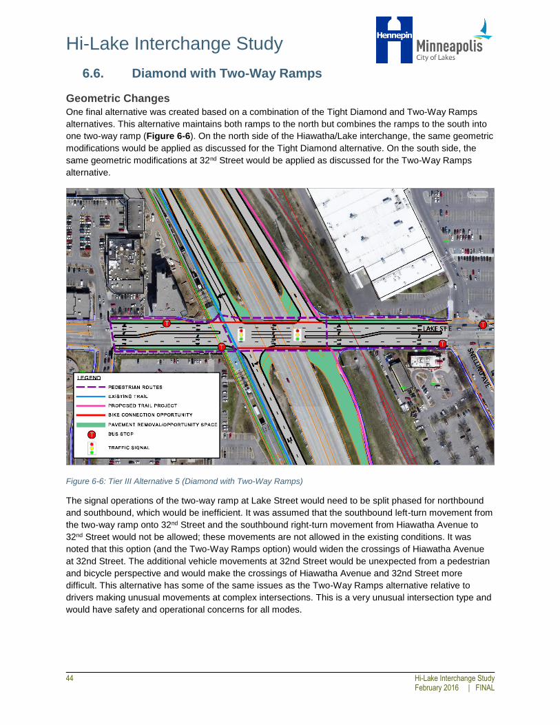
Hi-Lake Interchange Study
44 Hi-Lake Interchange Study
February 2016 | FINAL
6.6. Diamond with Two-Way Ramps
Geometric Changes
One final alternative was created based on a combination of the Tight Diamond and Two-Way Ramps
alternatives. This alternative maintains both ramps to the north but combines the ramps to the south into
one two-way ramp (Figure 6-6). On the north side of the Hiawatha/Lake interchange, the same geometric
modifications would be applied as discussed for the Tight Diamond alternative. On the south side, the
same geometric modifications at 32nd Street would be applied as discussed for the Two-Way Ramps
alternative.
Figure 6-6: Tier III Alternative 5 (Diamond with Two-Way Ramps)
The signal operations of the two-way ramp at Lake Street would need to be split phased for northbound
and southbound, which would be inefficient. It was assumed that the southbound left-turn movement from
the two-way ramp onto 32nd Street and the southbound right-turn movement from Hiawatha Avenue to
32nd Street would not be allowed; these movements are not allowed in the existing conditions. It was
noted that this option (and the Two-Way Ramps option) would widen the crossings of Hiawatha Avenue
at 32nd Street. The additional vehicle movements at 32nd Street would be unexpected from a pedestrian
and bicycle perspective and would make the crossings of Hiawatha Avenue and 32nd Street more
difficult. This alternative has some of the same issues as the Two-Way Ramps alternative relative to
drivers making unusual movements at complex intersections. This is a very unusual intersection type and
would have safety and operational concerns for all modes.

Hi-Lake Interchange Study
Hi-Lake Interchange Study 45 February 2016 | FINAL
Pedestrian and Bicycle Improvements The Diamond with Two-Way Ramps alternative allows the pedestrian/bicycle crossings of the
Hiawatha/Lake ramps to be shortened significantly, while also eliminating one east-west roadway
crossing altogether on the southeast side of the interchange. This space could be enhanced in a variety
of ways. Overall, all pedestrian evaluation measures are improved with the alternative, and the removal of
the islands would also allow for a southbound bicycle through movement.
At 32nd Street, as discussed for the Two-Way Ramps alternative, the roadway crossing would be
lengthened to accommodate the additional vehicle lane. The pedestrian and bicycle crossings would be
complicated as there would be added conflicts and more vehicle traffic
Transit Improvements
All benefits identified in the Tier II improvements would be maintained. The alternative could potentially
improve bus bridge operations as well by allowing buses to stop on the southbound approach to the
intersection to pick up and drop off passengers at a temporary stop.
Traffic Impacts The Diamond with Two-Way Ramp design would generally maintain or improve traffic operations at the
Hi-Lake interchange. However, in order to maintain two left turn lanes on the southbound approach, the
northbound and southbound approaches would need to operate using split phasing, which is less efficient
than the operations discussed for the other alternatives, and less growth could be accommodated
compared to other alternatives. Additionally, with the elimination of the islands, no physical barrier would
prevent vehicles from using the interchange to bypass congestion on Hiawatha Avenue.
At 32nd Street, signs would need to be installed to clarify that the northbound left turn lane would serve
vehicles headed to 32nd Street as well as Lake Street. Although no new phases would need to be added
to allow two-way operations on the Lake Street access segment, additional delay and queuing would be
expected. At the screening level of analysis conducted, light rail operational impacts on vehicle traffic are
not captured, and therefore vehicle delays may be greater than reported. As noted previously, MnDOT
expressed concern that eliminating any existing ramps at the intersection will cause greater than
anticipated operational impacts at 32nd Street (and potentially 28th Street), compounded by impacts
associated with LRT operations and uncertain diversion rates.
Key Benefits
Reclaimed pedestrian space
Reduced pedestrian/bicycle crossing distances and potential for median refuge on Lake Street
Potential for improved bicycle connection to the LRT station
More direct pedestrian routing
Reduced vehicle speeds
Opportunities for streetscape improvements
Opportunities for transit station enhancements
Improved transit reliability
Elimination of one roadway crossing
Key Issues
Increased potential for cut-through traffic from Hiawatha
Increased delays and queuing at 32nd Street and uncertainty regarding potential operational impacts due to LRT operations
Increased crossing distance and potential pedestrian/bicycle conflicts at 32nd Street

Hi-Lake Interchange Study
46 Hi-Lake Interchange Study
February 2016 | FINAL
Cost
$5,010,000 (2015 dollars)
6.7. Summary The benefits and issues discussed above represent a high level summary of a more detailed screening
level analysis of each alternative. For a direct comparison al all five alternatives, Appendix B includes a
completed evaluation matrix that quantifies the measures discussed. Appendix D provides detailed
summary tables of the traffic analysis performed to allow for a comparison of alternatives.
As noted previously in this section, the outcome of this study was not to identify a preferred alternative.
Additional stakeholder input and technical analysis/design should be conducted to recommend the
improvements that will move into the design and implementation phase. However, there is not currently
any funding programmed to implement the larger Tier III improvements or the more modest Tier I and II
improvements.
Additional agency coordination will be needed to determine the full impacts of any alternative that moves
forward. Though partner agencies were involved in this study, some alternatives may have broader
system impacts and trade-offs that may not be supported once more detail is known.

Hi-Lake Interchange Study
Hi-Lake Interchange Study 47 February 2016 | FINAL
7.0 APPENDICES
7.1. Appendix A: Existing, Tier II, and Tier III Concept Layouts
7.2. Appendix B: Tier III Evaluation Matrix
7.3. Appendix C: Detailed Evaluation Methodology
7.4. Appendix D: Traffic Analysis Results
7.5. Appendix E: Tier II and III Cost Estimates
7.6. Appendix F: Traffic Counts by Mode