Remote Condition Monitoring - University of Waterloo
24
Remote Condition Monitoring Carl Haas & Frederic Bosche, Saiedeh Razavi, Shahram Vaziri, Rashid Rehan, Khaled Berbash, Lixin Zhang, Sarah Baiz, Simon Marchand, Jongchul Song, David Grau, Carlos Caldas, Katherine Liapi, Hyoungkwan Kim, Alan Rauch, Hani Mahmassani, Haitham Logman, Shelley Bacik, Susan Tighe, et al.
Transcript of Remote Condition Monitoring - University of Waterloo

Remote Condition Monitoring
Carl Haas&
Frederic Bosche, Saiedeh Razavi, Shahram Vaziri, Rashid Rehan, Khaled Berbash, Lixin Zhang, Sarah Baiz, Simon Marchand, Jongchul Song, David Grau, Carlos Caldas, Katherine Liapi, Hyoungkwan Kim, Alan Rauch, Hani Mahmassani, Haitham
Logman, Shelley Bacik, Susan Tighe, et al.

Our Experiences with Remote Condition Monitoring
• RWIS (Remote Weather Information Systems)• Bridge scour• AID (Automated Incident Detection)• WIM (Weigh-in-Motion)• Traffic state estimation• Wireless communications• Web based video monitoring of projects• Hand held computers for inspection• Concrete maturity sensing via wireless embedded heat
sensors• Wireless corrosion sensing • RFID and GPS applications• LADAR and Laser scanning for 3D modeling

WIM: Why?A Tool for highway
preservation• Weight enforcement• Data collection (eg. ESALs)• Pavement design• Pavement management• Safety concerns• …

WIM Electronics• Data logger
(TCC 540 traffic counter, IRD)
• Smart modem • Battery charge• Solar panels • Piezo-electric strips
and ILD’s to trigger

CPATT WIM Site• Static weight station• SMA pavement
durable, smooth road surface
• After September 2006, about 200 vehicles per day

RFID/AVI tags, GPS, and Wireless
• supply chain management (tagging of containers, pallets and individual packages);
• infrastructure (tagging of building equipment and components);
• safety and security (vehicle collision avoidance, electronic pre-clearance of vehicles and individuals through security checkpoints, privacy issues); and
• system operations (electronic toll collection). • Etc.
• How:– Portals, and– Probes

Typical RFID Tags

Study Area for AID and traffic state estimation using AVI/RFID and ILD’s

RFID for Materials Management

Field Trials – Pipe Spools Tagged and Loaded on Truck
Load of 83 pipe spools tagged w/ i-Q tags
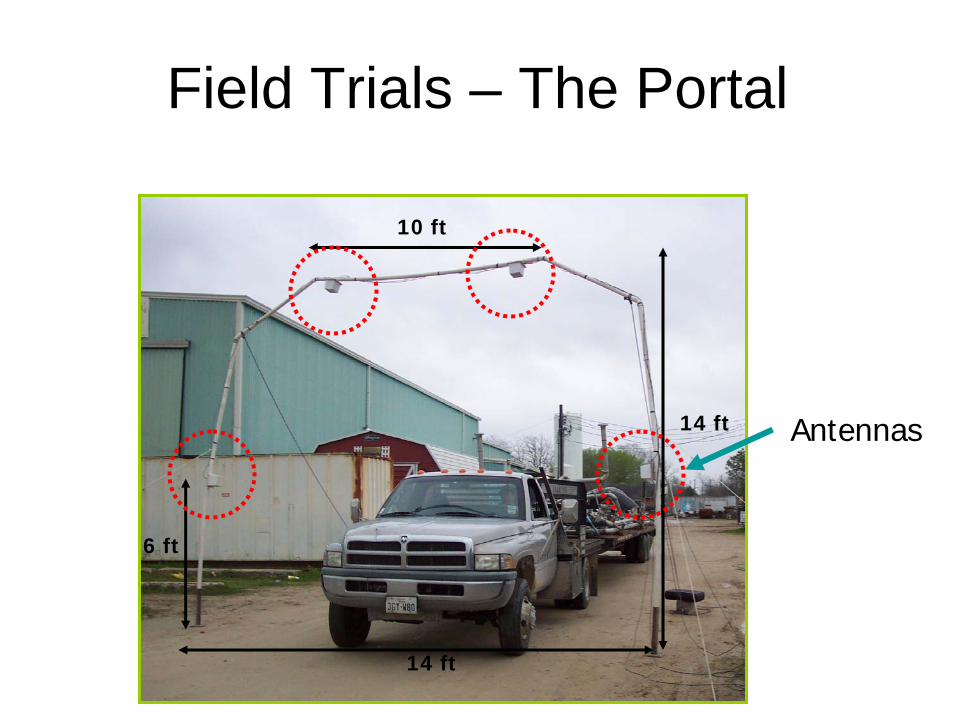
Field Trials – The Portal
Antennas
Cable to 4 antennasCable to 4 antennas
10 ft
14 ft
14 ft
6 ft

GPS Materials Locating

Preliminary Trial at KBR Office
• 20 barcode labels successfully found and identified

Pilot Trial
Manual GPS Reader
Number of Observations
81 81
Mean 6 min 42 sec 55 sec
Project Owner: BPGeneral Contractor: KBR
Time to locate each pipe spool

RFID and GPS for Asset Tracking
The foundation of effective asset management is an accurate inventory
Movable assets are challenging for maintaining an accurate and up-to-date inventory
Radio frequency identification (RFID) technology increases the ability of the organization to automatically acquire useful data about the location and status of assets

First Approach• desired infrastructure assets are tagged by active RFID
tags in advance • maintenance workers or inspectors are equipped with a
unit of GPS and an RFID reader. • Assets are being read automatically when inspectors
move throughout the infrastructure

3D Scanning and Modeling

Laser Profiler
LASS, UT Austin

3D Image Segmentation (Cont’d)
Segmented Image
Canny Edges With Liberal Threshold
Values
Original Particle Picture

0
20
40
60
80
100
0 10 20 30
LASS
Sieve
Sieve opening (mm)
6 kg Texas sample
Cumulative percent passing
Virtual Caliper / SieveExperimental Results of Size Characterization

e.g. 3D Laser Scanning (LADAR)
• For as-built drawings and data