Proposed Development Scheme...overlook parklands, a large central lake, unique waterways or wide...
68
Maroochydore City Centre Priority Development Area Proposed Development Scheme Maroochydore City Centre Priority Development Area January 2014 Proposed Development Scheme
Transcript of Proposed Development Scheme...overlook parklands, a large central lake, unique waterways or wide...

Maroochydore City Centre Priority Development Area Proposed Development SchemeMaroochydore City Centre Priority Development Area
January 2014
Proposed Development Scheme

Maroochydore City Centre Priority Development Area Proposed Development Scheme
The Department of State Development, Infrastructure and Planning is responsible for driving the economic development of Queensland.
© State of Queensland, Department of State Development, Infrastructure and Planning, November 2013, 100 George Street, Brisbane QLD 4000 (Australia).
Licence: This work is licensed under the Creative Commons CC BY 3.0 Australia licence. To view a copy of this licence, visit www.creativecommons.org/licenses/by/3.0/au/deed.en. Enquiries about this licence or any copyright issues can be directed to the Senior Advisor, Governance on telephone (07) 3224 2085 or in writing to PO Box 15009, City East, Queensland 4002.
Attribution: The State of Queensland, Department of State Development, Infrastructure and Planning.
The Queensland Government supports and encourages the dissemination and exchange of information. However, copyright protects this publication. The State of Queensland has no objection to this material being reproduced, made available online or electronically but only if it is recognised as the owner of the copyright and this material remains unaltered.
The Queensland Government is committed to providing accessible services to Queenslanders of all cultural and linguistic backgrounds. If you have difficulty understanding this publication and need a translator, please call the Translating and Interpreting Service (TIS National) on telephone 131 450 and ask them to telephone the Queensland Department of State Development, Infrastructure and Planning on telephone (07) 3227 8548.
Disclaimer: While every care has been taken in preparing this publication, the State of Queensland accepts no responsibility for decisions or actions taken as a result of any data, information, statement or advice, expressed or implied, contained within. To the best of our knowledge, the content was correct at the time of publishing.
Any references to legislation are not an interpretation of the law. They are to be used as a guide only. The information in this publication is general and does not take into account individual circumstances or situations. Where appropriate, independent legal advice should be sought.
An electronic copy of this report is available on the Department of State Development, Infrastructure and Planning’s website at www.dsdip.qld.gov.au To obtain a printed copy of this report, please contact us via the contact details provided at the end of this report.

Maroochydore City Centre Priority Development Area Proposed Development Scheme
Introduction....................................1
Strategic Context ..........................2
Land Use Plan ...............................7
Infrastructure Plan .......................50
Implementation Strategy..............53
Schedules.....................................55
1.0 Introduction....................................1
1.1 Economic Development Act.........................1
1.2 Priority Development Area............................1
1.3 Application of the development
scheme........................................................1
1.4 Elements of the development
scheme.... ...................................................1
1.5 Acknowledgements......................................1
2.0 Strategic Context...........................2
2.1 Location.......................................................2
2.2 Vision...........................................................3
2.3 Structural elements.......................................4
3.0 Land Use Plan................................7
3.1 Operation of the Land Use Plan....................7
3.2 Development assessment............................8
3.3 PDA-wide development criteria..................11
3.4 PDA Zones.................................................17
3.5 Precinct provisions.....................................17
4.0 Infrastructure Plan........................50
5.0 Implementation Strategy..............53
Schedules..........................................55
Schedule 1: Exempt development....................55
Schedule 2: Definitions.....................................57
Maps
Map 1 Maroochydore City Centre Priority Development Area boundary.......................................2
Map 2 Structural Elements Plan ......................6
Map 3 Zones and Precincts Plan....................18
Map 4 Precinct Development principles Plan.....................................20
Map 5 Maximum Building Heights..................45
Map 6 Road Hierarchy Plan...........................46

1.0 Introduction
1
1.1 Economic Development Act
The Economic Development Act 2012 (the Act) establishes the Minister for Economic Development Queensland (MEDQ), who operates as a corporation sole to exercise the functions and delegations of the MEDQ.
The main purpose of the Act is to facilitate economic development and development for community purposes in the State. The Act seeks to achieve this by establishing the MEDQ and providing for a streamlined planning and development framework for particular parts of the State declared as Priority Development Areas (PDAs).
1.2 Priority Development Area
The Maroochydore City Centre Priority Development Area (PDA) was declared by regulation on 19 July 2013.
1.3 Application of the Development Scheme
The Maroochydore City Centre PDA Development Scheme (the Scheme) is applicable to all development on land within the boundaries of the PDA.
From the date of approval under a regulation, the scheme replaces the Maroochydore City Centre PDA Interim Land Use Plan which commenced upon declaration.
1.4 Elements of the development scheme
The scheme consists of:
(a) a Vision;
(b) a Land Use Plan;
(c) an Infrastructure Plan; and
(d) an Implementation Strategy.
The vision for the PDA is expressed through the vision statement and structural elements plan; refer to Map 2 (Structural Elements Plan).
The Land Use Plan regulates development in the PDA and includes a Zones and Precincts Plan, as shown in Map 3 (Zones and Precincts Plan).
The Infrastructure Plan details the infrastructure necessary to support the Land Use Plan for the PDA.
The Implementation Strategy describes other strategies and mechanisms that will be used to complement the Land Use Plan and Infrastructure Plan to achieve the outcomes for the PDA.
1.5 Acknowledgements
The scheme was prepared under delegation by the Sunshine Coast Council in collaboration with key stakeholders including state agencies.

Strategic Context 2.0
2
Map 1 : Maroochydore City Centre Priority Development Area Boundary
2.1 Location
Maroochydore is a coastal urban area located on the Sunshine Coast in South East Queensland. It is approximately 100 kilometres north of Brisbane and is surrounded by natural assets - beaches, rivers and national parks. Maroochydore has an existing number of important functions accommodating major retail centres, government services, and residential areas for permanent residents and holiday makers alike.
The Maroochydore City Centre PDA is a 62 hectare site located centrally within Maroochydore on land including the former Horton Park Golf Course, State Government owned land, road and drainage reserve.
Comprising a largely undeveloped parcel of land in State Government and Council ownership, the PDA is located in the heart of Maroochydore and within walking distance of the coastline, with major roads surrounding it, including Maud Street, Maroochy Boulevard, Aerodrome Road and Plaza Parade.
Strategic Context - Location 2.0
6
1
4 3
2
5
Map is intended for illustration purposes only and unless stated is not to scale.
Produced by Economic Development Queensland (EDQ) 2013
Maroochydore State School
Maroochydore Police Station
Maroochydore Magistrates Court
Sunshine Plaza
Big Top Shopping Centre
Maroochydore Homemaker Centre
1
2
3
4
5
6
The PDA adjoins a number of existing urban precincts including the traditional town centre to the north, a regional shopping centre (Sunshine Plaza) to the north-west, and the Maroochydore Homemaker Centre adjoins the PDA to the west. The Aerodrome Road precinct and residential areas lie to the east of the PDA. Map 1 (Maroochydore City Centre Priority Development Area Boundary), shows the PDA boundary and location.
The Caboolture to Maroochydore Corridor Study (CAMCOS) rail alignment is located to access the PDA from the south and to terminate at the north of the PDA, running near to the western boundary.

3
A Transit Oriented Centre
The future investment and delivery of transit infrastructure - including both passenger and light rail - within Maroochydore will promote the new city centre as a key multi-modal hub within the Sunshine Coast. This will provide direct access and connectivity between local and regional centres, open space and coastal attractions.
A Sustainable New Centre
The growth and development of the new city centre provides the opportunity to implement new technologies, processes and environmental targets that will promote a cleaner, healthier and socially responsive future for Maroochydore. These will include subtropical design, energy efficiency, water cycle management, transit infrastructure and social and community facilities.
A Beautiful and Attractive Centre
New coastal contemporary buildings will overlook parklands, a large central lake, unique waterways or wide landscaped boulevards. Waterways and parklands will extend to where buildings may be positioned, creating openness and bringing sunshine, breezes and scenic vistas into the new city centre. These new places will create
ideal settings for retailing, offices, entertainment uses, restaurants and new residential accommodation.
A Vibrant and Engaging Centre
A variety of activities, uses and lifestyle opportunities within the new city centre will provide a range of safe, active and enjoyable places that are used frequently, both day and night, at all times of the year and by a wide cross section of the community. The new city centre will include a number of local, regional and tourism focussed destinations and activities.
A Safe and Inclusive Centre
The public realm will be a safe, inclusive and appealing environment for residents, visitors and workers within the new city centre, both day and night. Careful planning and design will ensure local streets, parkland and open spaces are integrated with surrounding land uses, have a wide range of activities and will be highly valued by the community.
2.0 Strategic Context - Vision
2.2 Vision
The Maroochydore City Centre PDA will be the business, community services and employment focus for the Sunshine Coast, with a diverse range and choice in housing and an efficient and effective multi-modal public transport system.
Development within the Maroochydore City Centre PDA will:
• create a city heart for Maroochydore and the Sunshine Coast;
• deliver fully approved and serviced land for commercial, retail, residential, civic, cultural and community uses;
• build publicly accessible waterways as a defining feature;
• facilitate rail based public transport via CAMCOS and possibly future light rail;
• create a multi-modal public transport system;
• deliver a new road network to provide additional capacity to the existing road network within Maroochydore;
• provide interconnected public open space; and
• establish a central Sunshine Coast location for regional entertainment and convention facilities.
A Centre of Economic Growth
Development in the Maroochydore City Centre PDA will deliver an integrated, new city centre that will support and promote existing areas in Maroochydore. Accordingly this will contribute to delivering economic and employment self-containment to the Sunshine Coast region.
Growth of the new city centre will provide a mix of uses, activities and development opportunities that will attract economic, commercial and social investment, both on a national and international scale. It will deliver regional employment opportunities as the identifiable centre for business, retail, services, cultural and commercial activity.
A Walkable City Centre
The new city centre will place high importance on walking and cycling as the key mode of transit. Safe, shaded and well connected linkages will promote and improve non-vehicular movement both within the new city centre as well as providing linkages to surrounding land uses, open space, parkland, other retail and service areas, and the coastline.
Strategic Context 2.0
4
Strategic Context - Structural elements 2.0
2.3 Structural Elements
The structural elements are identified in Map 2 (Structural Elements Plan). The structural elements show how the vision will be physically expressed in the PDA.
Development within the PDA should support the delivery of the following elements:
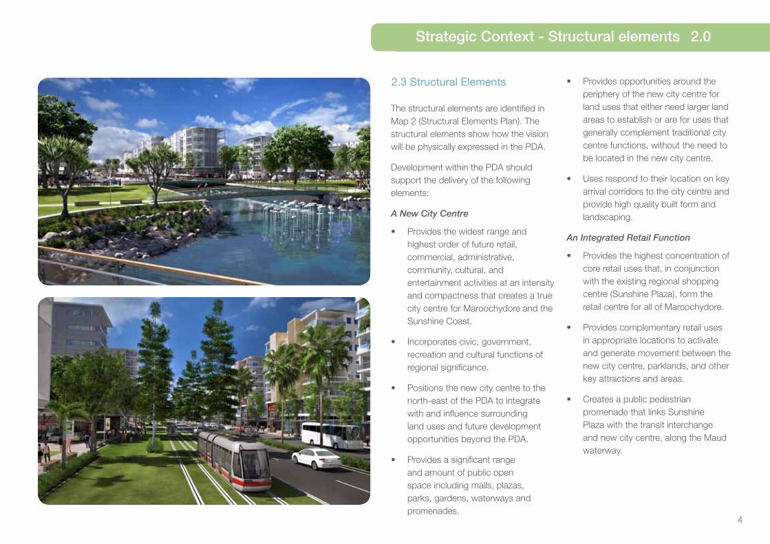
A New City Centre
• Provides the widest range and highest order of future retail, commercial, administrative, community, cultural, and entertainment activities at an intensity and compactness that creates a true city centre for Maroochydore and the Sunshine Coast.
• Incorporates civic, government, recreation and cultural functions of regional significance.
• Positions the new city centre to the north-east of the PDA to integrate with and influence surrounding land uses and future development opportunities beyond the PDA.
• Provides a significant range and amount of public open space including malls, plazas, parks, gardens, waterways and promenades.
• Provides opportunities around the periphery of the new city centre for land uses that either need larger land areas to establish or are for uses that generally complement traditional city centre functions, without the need to be located in the new city centre.
• Uses respond to their location on key arrival corridors to the city centre and provide high quality built form and landscaping.
An Integrated Retail Function
• Provides the highest concentration of core retail uses that, in conjunction with the existing regional shopping centre (Sunshine Plaza), form the retail centre for all of Maroochydore.
• Provides complementary retail uses in appropriate locations to activate and generate movement between the new city centre, parklands, and other key attractions and areas.
• Creates a public pedestrian promenade that links Sunshine Plaza with the transit interchange and new city centre, along the Maud waterway.

5
Community Assets
• Establishes a civic focus and identity for Maroochydore.
• Creates a significant community asset – a key ‘anchor’ use, gathering place and community focal point – on land designated to the north of the central parkland, and within walking distance of the future transit interchange.
• Creates high quality and permeable connections that link the PDA to existing civic uses to the north, via high quality open space, public transport, cycle ways and streetscapes.
Road and Infrastructure Network
• Establishes a robust and permeable city grid pattern connecting into the surrounding road network, improving accessibility and permeability into and across the PDA, and to the broader Maroochydore areas.
• Establishes appropriate access points (through development or land acquisition) to integrate the city grid and connect the PDA to the surrounding road network and development potential beyond the PDA.
• Creates strong vehicular and non-vehicular linkages external to the PDA.
• Maximises access to public transport and encourages walking and cycling.
• Integrates suitable active land uses in alignment with the future transit interchange, light rail and existing transit interchange.
• Provides suitable interim land uses that support or allow for future infrastructure around identified transport corridors, alignments and interchanges.
2.0 Strategic Context - Structural elements
Residential Value
• Creates an ‘urban village’ framed by the retail core, transit interchange and central parkland, suitably located to optimise amenity and convenience.
• Provides for permanent residential and tourist accommodation to be provided at an appropriate scale that supports growth and choice within the PDA, and integrates with and enhances existing Maroochydore living.
• Provides a range of dwelling types and sizes to facilitate social mix, meet changing demographic needs and opportunities for affordable living.
• Allows park vistas and park access at the end of each local street.
• Aligns blocks east to west to maximise buildings having a northern aspect.
Parklands and Water
• Provides significant public open space areas including malls, plazas, parks and gardens.
• Provides a large central parkland that connects to a variety of high quality and integrated urban parks and waterways.
• Provides for a parkland focus on the Maud waterway and provides for a wide range of informal active and passive recreation facilities and gathering spaces.
• Creates an urban water feature through the realignment of the Maud waterway to act as ‘the Corso’ - a primary movement corridor and pedestrian promenade.
• Incorporates development around a central lake and water passages as a value adding community asset and destination.
• Accommodates flood storage in the PDA, with an area of not less than 8.4 hectares.
• Landscape and open space reinforces the new city centre’s subtropical and coastal lifestyle, climate and identity.

6
Map 2: Structural Elements Plan
Legend
New City Centre and Integrated Retail Core
Other Development
Parkland
Key community / entertainment facilities
PDA Boundary
Major Boulevard Roads
Urban Open Space Links
Lakes and Waterways
Future Light Rail (indicative alignment subject to further investigations)
Future Passenger Rail Infrastructure (CAMCOS)
Strategic Context - Structural elements 2.0

7
3.0 Land Use Plan - Operation
3.1 Operation of the Land Use Plan
3.1.1 Purpose of the Land Use Plan
The Land Use Plan establishes the PDA development requirements that regulate development to achieve the vision for the PDA.
The Land Use Plan seeks to facilitate development of the PDA and enable longer term development to occur that is consistent with the vision and contributes to the delivery of the PDA.
3.1.2 PDA Development Requirements
The PDA development requirements are expressed as:
(i) PDA-wide development criteria (see section 3.3)
(ii) Precinct provisions (see section 3.5).
The PDA-wide development criteria apply to all assessable development in the PDA but do not apply to exempt development.
The precinct provisions for each precinct apply to:
(i) land in that precinct (precinct intents and preferred land uses)
(ii) all development in that precinct (Precinct Levels of Assessment Tables).
The Department of State Development Infrastructure and Planning (DSDIP) guidelines provide guidance on how to achieve the PDA-wide development criteria and Precinct provisions.
3.1.3 Levels of Assessment
Levels of assessment tables in Section 3.5 prescribe for each precinct:
(i) PDA exempt development (column 1)
(ii) PDA self-assessable development (column 2)
(iii) PDA assessable development which is permissible (column 3A)
(iv) PDA assessable development which is prohibited (column 3B).
3.1.4 Schedules
Schedule 1 identifies development that is exempt from assessment for the whole of the PDA.
Schedule 2 provides the use and administrative definitions required to interpret and apply the development scheme.
Figure 1: Purpose of the Land Use Plan and relationship of development scheme components
Vision (including Structural Elements)
PDA Development Requirements
PDA-wide development criteria
• Urban design and sustainability
• Centres design and function
• Maximum development yields
• Street and movement network
• Environment and open space
• Community safety and development constraints
Precinct provisions
• Structural elements plan (Map 2) and Zones and Precincts Plan (Map 3)
• Precinct provisions
• Levels of Assessment Tables (Section 3.5)
• Precinct Plans
Schedules• PDA-wide exempt development
• Definitions
DSDIP Guidelines

8
Land Use Plan - Development Assessment 3.0
3.2 Development assessment
3.2.1 Interpretation
Section 33 of the Act defines development.
Schedule 2 defines particular words used in this scheme, including uses and administrative terms.
3.2.2 Development Application
To the extent the PDA-wide development criteria, zone intents, precinct provisions and the DSDIP guidelines are relevant, they are to be taken into account in the preparation of a PDA development application and the assessment of the application by the MEDQ.
The Infrastructure Plan and Implementation Strategy may include further information which should be taken into account in the preparation, design and feasibility of development proposals.
3.2.3 Development approval
Identification of development as PDA assessable development does not mean that a PDA development approval (with or without conditions) will be granted.
PDA assessable development requires a PDA development application to be lodged with the MEDQ for assessment and decision.
Approval of a development permit is required before PDA assessable development is undertaken.
3.2.4 Development consistent with the Land Use Plan
PDA assessable development is consistent with the Land Use Plan if:
a. the development complies with all relevant PDA-wide development criteria, zone intent, precinct provisions and precinct plan; or
b. the development does not comply with one or more of the aspects of the PDA-wide development criteria, zone intents, precinct provisions or precinct plan but:
i. the development does not conflict with the PDA vision; and
ii. there are sufficient grounds to justify the approval of the development despite the non compliance with the PDA-wide development criteria, zone intents, precinct plan or the precinct provisions.
In this section ‘grounds’ means matters of public interest which include the matters specified as the main purposes of the Act as well as:
a. superior design outcomes; and
b. overwhelming community need.
The term ‘grounds’ does not include the personal circumstances of an applicant, owner or interested third party.
3.2.5 Development Inconsistent With The Land Use Plan
PDA prohibited development is inconsistent with the Land Use Plan. Under the Act, PDA assessable development that is inconsistent with the Land Use Plan cannot be granted approval.
3.2.6 Demonstrating development is consistent with the Land Use Plan
PDA assessable development must demonstrate how it is consistent with the PDA vision, PDA-wide development criteria and precinct provisions and should demonstrate that development will not compromise or unreasonably prejudice opportunities for the development of the remaining area in the precinct. Suggested ways applicants may demonstrate this is through a preliminary approval or Plan of Development (PoD).
3.2.7 Precinct Plan Requirement
Prior to the approval of a Plan of Development (PoD) or the first development application for permissible development, a (Precinct Plan) must be approved.
A Precinct Plan must be approved for each of the Precincts nominated on Map 3 (Zone and Precincts Plan).
The Precinct Plan must demonstrate how the precinct intent and precinct outcomes are achieved and include the following:
i. the nomination of sub-precincts to which a PoD may apply;
ii. how the maximum yields for the precinct will be achieved including the anticipated scale and distribution of land uses for each precinct; and
iii. any additional development requirements for the sub-precinct in order to achieve the required precinct outcomes.
A Precinct Plan must be consistent with the PDA-wide development criteria, zone and precinct intent.

9
3.0 Land Use Plan - Development assessment
3.2.8 Preliminary Approval
There is no requirement to obtain a PDA preliminary approval1. However, applicants may choose to use preliminary approvals to stage development or to gain approval for a development concept before undertaking detailed planning.
In this regard preliminary approvals may demonstrate how development achieves the requirements of the development scheme at an intermediate level of spatial planning between the broad spatial framework of the Structural Elements Plan (Map 2) and precinct provisions and the individual development proposals and associated Plans of Development (PoDs).
A preliminary approval may include the following:-
i. all or a relevant part of the precinct determined in consultation with the MEDQ
ii. identify the location of connections to network infrastructure, including transport, within the precinct
iii. identify land uses and development density
iv. resolve if required, any development constraints that may determine the extent of the developable area or appropriate uses
v. resolve the boundaries of centres, public open space and any identified sites for community infrastructure, and
vi. demonstrate that the development proposal:
¾ does not prejudice the ability for surrounding land to be developed in an orderly and efficient manner consistent with the PDA vision, PDA-wide development criteria and precinct provisions
¾ addresses additional requirements for development in the precinct
¾ is consistent with existing and approved development in the preliminary approval area or adjoining areas
¾ addresses other matters specified in a guideline issued by DSDIP.
Applicants should discuss the use of a preliminary approval with the MEDQ.
3.2.9 Plan of Development
A Plan of Development (PoD) may accompany an application for a material change of use or reconfiguring a lot and may deal with any proposed use as well as operational work.
A PoD is prepared by an applicant and may include maps, graphics and text that collectively demonstrate how proposed uses, works and lots will contribute towards the achievement of the vision and will be consistent with the relevant PDA development requirements and precinct provisions.
A PoD should indicate the location and function of temporary and permanent uses and structures and how these uses and structures will relate to each other.
The PoD cannot include land beyond the boundary of the land the subject of the application, but may cover only part of the land the subject of the application. An applicant may also be required to demonstrate impacts and connections to areas adjoining the subject land in a separate plan to the PoD.
Under the precinct Levels of Assessment Tables, development approved in accordance with a PoD is exempt development and requires no further development approval under the scheme.
3.2.10 Infrastructure Agreements
A PDA development condition may require the land owner to enter into an infrastructure agreement to address the provisions and requirements of the Infrastructure Plan and Implementation Strategy.
3.2.11 Notification Requirements
A PDA development application will require public notification if the application: -
a. includes a proposal for development which does not comply with Map 2 (Structural Elements Plan) and Map 3 (Zones and Precinct Plan), their intent or the precinct provisions; or
b. is for development which in the opinion of the MEDQ, may have adverse impacts on the amenity or development potential of adjoining land under separate ownership, including development for a non-residential use adjacent to land approved for or accommodating a residential use in the residential precinct.
The MEDQ may require public notification in other circumstances if the development application is for a use or of a size or nature which, in the opinion of the MEDQ, warrants public notification.
1 A PDA preliminary approval is a PDA development approval that approves development subject to conditions, but does not authorise PDA assessable development to take place. A PDA development permit is required in order to carry out PDA assessable development.

10
3.2.12 Relationship with local government planning scheme and other legislation
The development scheme may apply a provision of a planning instrument or a plan, policy or code made under the Sustainable Planning Act 2009 (SPA) or other legislation. However, the development scheme prevails to the extent of any inconsistency with those instruments.
3.2.13 Other legislation
In addition to assessment against the development scheme, development may require assessment against other legislation including for example the Plumbing and Drainage Act 2002 and the Sustainable Planning Act 2009.
3.2.14 Land not included in a precinct
This section applies to land which is not shown in the Land Use Plan as being included in a precinct (unallocated land).
Where the unallocated land adjoins land in a precinct, the unallocated land is deemed to be included in that precinct.
Where the unallocated land adjoins land included in different precincts, the unallocated land is deemed to be included in those precincts with the centreline of the unallocated land being the boundary between the precincts.
3.2.15 Interim use
An interim use is a land use that, because of its nature, scale, form or intensity, is not appropriate for long term use of the land.
Interim land uses may occur if appropriately developed and operated and where located in areas which will not compromise the precinct provision in the longer term.
The MEDQ may approve an interim use if it can be demonstrated that an interim use will not preclude or delay an appropriate long term use or intensity of development.
Information to support an application for an interim use may include:-
• a schedule of land supply and projected take-up rates, or
• plans showing how the development could transition from the proposed interim use to an appropriate longer term use.
The MEDQ may impose a condition of approval that limits the duration of an interim use.
Interim uses will only be approved if it can be demonstrated that the use will not prejudice the achievement of the vision for the PDA.
Land Use Plan - Development Assessment 3.0

11
3.0 Land Use Plan - PDA-wide development criteria
3.3 PDA-wide development criteria
The following criteria apply to all PDA assessable development in the Maroochydore City Centre PDA. To the extent that the criteria are relevant, they are to be taken into account in the preparation of PDA development applications and the assessment of those applications2.
The PDA-wide development criteria support the delivery of the structural elements expressed in Section 2.3 and Map 2 (Structural Elements Plan).
The PDA-wide development criteria should be read in conjunction with the relevant precinct provisions.
The Infrastructure Plan and Implementation Strategy may include further information, which should be taken into account in the design and feasibility of development proposals.
For more detail regarding how to comply with the specific development requirements listed below refer to relevant guidelines.
3.3.1 Urban Design and Sustainability
3.3.1.1 Neighbourhood planning
The form, type and arrangement of streets and open space:
a. achieves good neighbourhood planning and design outcomes;
b. contains significant residential and non-residential uses consistent with the PDA vision;
c. provides a mix of lot sizes and range of urban forms to accommodate mixed use, commercial, residential, community use and retail functions;
d. delivers a varied pattern that connects into the existing street grid which is permeable and legible, promoting walking and cycling;
e. achieves an appropriate interface with existing residential and commercial development adjoining the PDA boundary by:
i. considering densities through minimum lot sizes and the location of property boundaries;
ii. access arrangements;
iii. uses; and
iv. height; and
f. Supports a range of residential options and innovations within the PDA to reflect opportunities for student, live-work, and other housing types.
3.3.1.2 Placemaking
Development is to:
a. contribute to a sense of place;
b. provide a strong identity expressed through architecture, urban design, landscaping and appropriate signage at key locations;
c. establish public spaces which contribute to a variety of activities in the public realm;
d. provide a safe environment through the application of Crime Prevention through Environmental Design (CPTED) principles such as passive surveillance through residential neighbourhoods and open spaces;
e. provide for landmark buildings to create gateways and way-finding landmarks;
f. create an attractive and appealing place for residents which promotes walking and cycling and is permeable, legible and connected to surrounding areas;
g. provide for new and future technologies in the public realm which may include fibre optic to all lots, wi-fi connectivity, LED street lighting, smart lighting, smart traffic lights, smart parking systems and video surveillance of open space, streets and public realm; and
h. provide a relaxed, casual and outdoors oriented centre, through the integration and connection of water and parkland within and around the city streets, buildings and parklands.
3.3.1.3 Built Form
The form of buildings delivers:
a. high design standards and contributes to overall new city centre qualities;
b. site responsiveness which:
i. creates a recognisable town centre through the intensity, appearance, height, scale and mass of built form;
ii. delivers building heights and densities which are appropriate in the context of surrounding development and the precinct provisions in Section 3.5;2Applicants should have regard to the State Planning Policy
(SPP) December 2013, associated guidance and supporting material including mapping.

12
Land Use Plan - PDA-wide development criteria 3.0
iii. provides building setbacks that are sufficient to ensure the building:
¾ does not dominate the street or neighbouring built form;
¾ does not prejudice the development of adjoining sites;
¾ creates attractive and viable communal spaces and deep planting zones at the front and rear of the building; and
¾ has access to sufficient light and ventilation;
iv. provides built to boundary (0m setbacks) on front and side boundaries only;
v. ensures ground and podium levels of the building contribute to a fine grained, articulated streetscape, exhibiting human scale and creating interest in the facade;
vi. ensures buildings address the street and integrate with the public realm to support pedestrian connectivity and activity;
vii. maximises views to parks and waterways for buildings and streets; and
3 Refer to:
¾ EDQ Guidelines and Practice Notes, and
specifically to Guideline 2 - Accessible Housing, on
the DSDIP web-site http://www.dsdip.qld.gov.au/
resources/priority-development-areas-guidelines-
and-practice-notes.html ;
¾ Sunshine Coast Affordable Living Strategy 2010-
2020.
viii. ensures buildings located on the boundaries of the PDA are designed to provide an appropriate transition to buildings on adjoining sites;
c. Building detail which:
i. allows for larger consolidated floor plates for commercial development;
ii. ensures floor plates and ceiling heights provide for flexibility and consideration for future technologies and uses;
iii. allows for rooftop terraces, landscaping, entertainment and lifestyle uses on podium and lower levels that overlook the main street boulevard, plazas and parklands;
iv. maximises recycling opportunities and reduces waste generation; and
v. ensures adequate visual and noise amenity; and
d. Sub-tropical design which:
i. ensures residential design provides safety, privacy, comfort and responsiveness to the Sunshine Coast’s sub-tropical climate;
ii. ensures optimum solar access and north facing orientation for residential uses where possible to respect the local climatic opportunities;
iii. utilises energy efficient, climatically responsive design including appropriate solar orientation, shading, cross ventilation, natural lighting and passive cooling techniques; and
iv. incorporates green walls or roofs where possible to create feature elevations and reduce heat sink effects.
3.3.1.4 Affordable Living
Residential development (including residential components of a mixed use development) should deliver housing choice to suit a variety of households including: families, singles, couples, work-at-home occupiers, students, retirees, group accommodation households and people with special needs, by offering universal design and a variety in size, configuration, cost, location and tenure.
Development:
a. Contributes to affordable living3;
b. achieves housing choice and diversity;
c. incorporates universal design; and
d. incorporates adaptable housing.

13
3.3.4 Street and movement network
Development provides for a well designed street and movement network which:
a. creates an accessible centre, well connected to the surrounding urban area and sub-region, providing for future transit corridors for passenger and light rail;
b. provides a range of street typologies that respond to the development intent of each precinct and specific outcomes of the overall city street hierarchy as shown in Map 6 (Road Hierarchy Plan);
c. has a clear structure and maximises walking, cycling and public transport effectiveness in that pedestrian and cyclist links are direct, convenient, legible, comfortable and safe and connect with all major land uses, key destinations, public transport and existing transit infrastructure;
d. connects to and takes into consideration impacts to existing networks, ensuring acceptable levels of amenity and minimising negative impacts of through traffic;
e. provides well designed lighting, pavement treatment and materials, clear sight lines and landscaping 5;
3.3.2 Centres Design and Function
Future development:
a. delivers the vision for a new city centre for Maroochydore and the Sunshine Coast;
b. delivers a new and identifiable ‘heart’ for the Sunshine Coast that will attract economic, commercial and social investment, whilst also creating an attractive and appealing place for residents, workers and visitors;
c. ensures that future transit infrastructure creates an accessible centre, well connected to the surrounding urban area and sub-region, through the provision of corridors for passenger and light rail directly into the new city centre;
d. delivers sites for a new significant community facility, library, civic uses and entertainment, exhibition and convention centre, all of which are connected and set within high quality parkland, water ways and landscaped boulevards;
e. provides retail opportunity on the ground floor in identified mixed use precincts;
4A Precinct Plan that seeks to exceed the maximum
development yield must be accompanied by:
(a) an infrastructure network analysis that demonstrates
that the additional yield will not compromise the planned
infrastructure networks for the PDA, in particular the planned
transport infrastructure network; and
(b) an economic impact assessment for additional retail
proposed for precincts other than Precinct 3 (Retail Core) that
demonstrates:
(i) how the proposed additional area will complement and
not compromise the Maroochydore Principal Regional
Activity Centre and the Sunshine Coast Centres Hierarchy;
and
(ii) that the additional yield provides for increased
employment opportunities within the PDA.
5 Refer to Austroads - Guide to Road Design Part 6A - Pedestrian and Cycle Paths.
f. makes adequate provision for public transport infrastructure including bus stops and indent bays at appropriate locations in conjunction with Translink;
g. provides end of trip facilities for pedestrians and cyclists, including secure undercover bicycle storage facilities, showers and lockers;
3.0 Land Use Plan - PDA-wide development criteria
f. provides sufficient car parking through an integrated and convenient car parking layout; and
g. embraces new technologies, including digital and broadband, in order to expand business markets and compete nationally and globally.
3.3.3 Maximum Development Yields
The maximum development yield for the PDA allowable under this development scheme will be in the order of:
¾ Retail - 75,000m2 GFA; and
¾ Commercial - 165,000m2 GFA
While no maximum yield is placed on residential development in the PDA, it is intended that around 2,000 residential dwellings will be provided as a key outcome for the PDA.
Yield intents for precincts are described in Section 3.54.
The maximum development yields for the PDA are derived from the capacity of the currently planned infrastructure networks for the PDA, in particular the road transport infrastructure network.
Development seeking to exceed the GFA limits specified above will be assessed under Section 3.2.4 b of the development scheme.

14
h. provides cycle parking in the public realm;
i. does not unreasonably constrain future provision of public transport infrastructure and does not adversely impact on existing or future public transport corridors;
j. ensures potential public transport routes are constructed to a standard appropriate to accommodate services, footpaths and pavements;
k. ensures vehicle access and parking is safe and convenient for residents, workers, visitors and service providers;
l. provides for a range of off-street parking options that may service both non-residential and residential uses; and
m. ensures any car parking structures are suitably sleeved.
Development makes adequate car parking provision for the number and nature of vehicles expected and in compliance with Table 1 (Maroochydore City Centre PDA Car Parking Rates).
Table 1: Maroochydore City Centre PDA Car Parking Rates
Land Use Interim
(prior to the provision of first high capacity mass transit6 public
transport service)
Long Term
(after the provision of first
high capacity mass transit6
public transport service)
Residential 1 space per dwelling unit 1 space per dwelling unit
Commercial 1 space per 40m2 GFA on-site
50% to be provided on-site
50% may be provided in a shared centrally located and managed interim car parking facility or fees paid in lieu of off-site car parking, in accordance with a car parking infrastructure agreement.
1 space per 80m2 GFA
Retail 1 space per 20m2 GFA
30% to be provided on-site
70% may be provided in a shared centrally located and managed interim car parking facility or fees paid in lieu of off-site car parking, in accordance with a car parking infrastructure agreement.
1 space per 40m2 GFA
Services,
community and
other uses
1 space per 20m2 GFA
Where the applicant can provide technical assessment that demonstrates suitable alternative car parking provision for uses under this category, the alternative rates will be assessed by the assessment manager based on relevant merit.
1 space per 20m2 GFA
Land Use Plan - PDA-wide development criteria 3.0
6 ‘High Capacity Mass Transit’ is defined as light rail, passenger rail (CAMCOS) or high frequency dedicated bus service.

15
g. provides a public pedestrian promenade - the ‘Corso’ - extending along the full frontage of the Maud waterway to the future transit station and interchange;
h. integrates adjacent built form to overlook public open space and parklands, providing active frontages, passive surveillance and value adding frontages;
i. provides safe and well lit public open space by applying Crime Prevention Through Environmental Design Principles (CPTED);
j. delivers shade structures, landscaping and directional signage in public domain areas;
k. provides safe public footpaths, cross block links and pathways that have a high level of accessibility and are quality pedestrian and bicycle environments; and
l. capitalises on the value and amenity of waterways by maximising public accessibility.
3.3.5.2 Environment
Development in the PDA:
a. will be sensitive to environmental matters;
b. adequately addresses any environmentally significant matters, including any disturbance of marine plants;
c. seeks to incorporate tidal fish habitats and fish passage within waterways, specifically the realignment of the Maud Street drain7;
d. protects and retains where possible ecological values, existing mature trees including hollow bearing trees, remnant vegetation and fauna habitat;
e. incorporates landscaping with endemic species with a preference towards retaining existing endemic vegetation where possible;
f. utilises planting strategies that are site responsive and reflect the subtropical nature of the Sunshine Coast; and
g. minimises adverse impacts on receiving waters and appropriately manage stormwater including use of water sensitive urban design principles.
3.3.5 Environment and open space
3.3.5.1 - Open Space
Development for open space in the PDA:
a. incorporates the following key components:
i. major parkland; and
ii. an urban waterbody of not less than 8.4 hectares in area;
b. connects parks and open space within and adjoining the new city centre, to be accessible for all users as pedestrian and cycle friendly environments;
c. accommodates a wide variety of uses, activities, themes and purposes for both day and night time activities;
d. provides high levels of access to a public open space and a civic plaza that serves as a community focal point and gathering place;
e. treats the Maud waterway as a key landscape feature that supports inter-connectivity in the new city centre and to broader urban areas;
f. incorporates public art;
3.0 Land Use Plan - PDA-wide development criteria
7 Refer to:
Fisheries Guidelines for Fish-friendly structures, Fish Habitat
Guideline FHG 006 http://www.daff.qld.gov.au

16
3.3.6 Community safety and development constraints
Development is to:
a. be sited, designed and constructed to avoid, minimise or withstand the incidence of a development constraint;
b. ensure that people and property are safe from potential hazards including acid sulfate soils, flooding, and coastal hazards 8;
c. ensure that building and/ or structures do not intrude into the Obstacle Limitation Surface (OLS) for the Sunshine Coast Airport 9;
d. ensure the design, siting, and layout of development adjoining the public transport rail corridor addresses noise impacts and where necessary incorporates noise mitigation measures;
e. take into account the projected impacts of a variable climate;
f. manage and minimise noise from transport corridors 10; and
g. minimise adverse impacts on amenity during construction.
3.3.6.1 Natural Disaster Resilience
To ensure suitable natural disaster resilience 11, development:
a. ensures that the finished ground surface levels of lots after building development are above the defined flood event12 to protect the development from the risk of flooding;
b. allows that undeveloped lots subject to subsequent building work likely to involve basement excavation, may temporarily have lower ground surface levels which may be raised to above the defined flood event at the time of building work utilising fill material from basement excavation works; and
c. ensures all lots are free draining, avoid pondage of stormwater and do not cause adverse amenity impact or other nuisance.
Development provides an efficient drainage network 13 which:
a. provides capacity for stormwater discharge;
b. minimises flood risk from major rainfall events; and
c. does not result in adverse impacts upstream or downstream.
8 Refer to:
¾ State Planning Policy (SPP) December 2013, associated guidance and supporting material including mapping.
¾ relevant DSDIP guidelines.
¾ Cornmeal Creek Flood Study - November 2013
prepare by Cardno.
9 Refer to Regulatory Map 1.8 Sunshine Coast Airport Obstacle
Limitation Surface of the Sunshine Coast Council’s Maroochy
Plan 2000.
10 Refer to the Department of Transport and Main Roads Traffic
Noise Management: Code of Practice with respect to external
road traffic noise levels; and the Queensland Development
Code and Section MP4.4 Buildings in a Transport Noise
Corridor.
11 NB The Queensland Reconstruction Authority notes the
Flood Hazard Overlay Map OVM51H (draft Sunshine Coast
Planning Scheme 2012) identifies a significant portion of the
site affected by river and storm tide flooding. Development in
these areas must ensure it does not increase the inherent risk
of people and property to the potential impacts of flooding.
Development should be able to remain functional during and
after a natural hazard event.
12 Defined flood event is the ARI 100 (climate change) flood
event. (refer to the Cornmeal Creek Flood Study - Nov 2013
prepared by Cardno.
13 Refer to the State Planning Policy (SPP) December 2013, associated guidance and supporting material including
mapping and the Urban Stormwater Quality Planning Guidelines
2010.
Land Use Plan - PDA-wide development criteria 3.0

17
3.0 Land Use Plan - PDA zones
3.4 PDA Zones
Land within a PDA may be allocated a zone.
The zones are grouped in the following three categories: Principal Centre (CBD) Zone, High Density Residential Zone and Recreation and Open Space Zone.
The zones in the PDA are described below.
Principal Centre (CBD) Zone
The purpose of the Principal Centre Zone is to provide for the largest and most diverse mix of uses and activities that form the core of the urban centre. It includes key concentrations of high order retail, commercial, employment, residential, administration, community, cultural, recreational and entertainment activities and other uses capable of servicing the region.
High Density Residential Zone
The purpose of the High Density Residential Zone is to provide for medium and high density residential activities predominantly comprising multiple dwelling residential development for permanent residents supported by community facilities and small-scale services and facilities that cater for local residents.
Recreation and Open Space Zone
The purpose of the Recreation and Open Space Zone is to provide for a range of recreation, leisure, cultural and educational activities. The zone provides for parks that serve the recreational needs of residents and visitors.
3.5 Precinct provisions
3.5.1 -Introduction
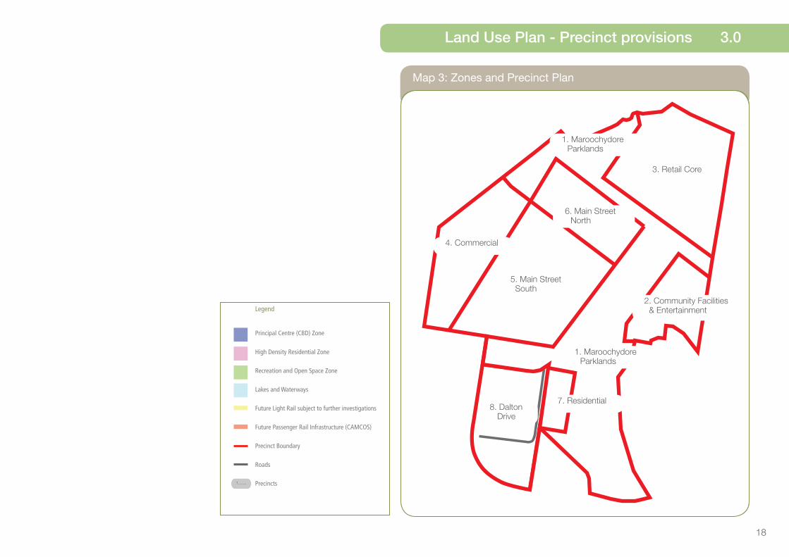
Eight precincts are identified in the PDA. These precincts and their locations are shown on Map 3 (Zones and Precincts Plan).
The precincts are as follows:
Precinct 1 – Maroochydore Parklands Precinct
Comprises key urban green space elements, including the central east-west public promenade green spine - the ‘Corso’, - central parkland, the lakelands centre piece, a civic plaza, recreation parks and gathering spaces, and a regional library.
Precinct 2 - Community Facilities and Entertainment Precinct
A community heart for Maroochydore, with major entertainment, tourism and community activities, integrated into the adjoining Maroochydore Parklands Precinct with high quality landscape and waterway treatments, public art and plaza spaces; and incorporating high sustainability and energy efficiency targets.
Precinct 3 - Retail Core Precinct
Comprises a highly pedestrianised and high intensity mixed use core with the highest concentration of retail floor space in the PDA.
Precinct 4 - Commercial Precinct
Comprises predominantly medium intensity commercial development and employment uses providing for larger floor area uses.
Precinct 5 - Main Street South Precinct
Predominantly medium and high intensity residential and commercial development with significant permanent residential and some lower levels of offices above the ground storey.
18
Map 3: Zones and Precinct Plan
Land Use Plan - Precinct provisions 3.0
1. Maroochydore Parklands
1. Maroochydore Parklands
3. Retail Core
2. Community Facilities & Entertainment
5. Main Street South
6. Main Street North
4. Commercial
8. Dalton Drive
7. Residential
Legend
Principal Centre (CBD) Zone
High Density Residential Zone
Recreation and Open Space Zone
Lakes and Waterways
Future Light Rail subject to further investigations
Future Passenger Rail Infrastructure (CAMCOS)
Precinct Boundary
Roads
Precincts1........
19
3.5.2 - Precinct Provisions
Precinct provisions seek to provide guidance on where land uses and development within the PDA are preferred and to support the achievement of the longer term development of the PDA.
Interim uses, should however have regard to the impacts on the longer term development of the PDA and ensure the delivery of infrastructure including the street and movement network, is consistent with the PDA-wide development criteria, zone intent and precinct provisions.
Precinct provisions should be read in conjunction with Section 2.3 Structural elements and Map 2 (Structural Elements Plan), zone intents and the PDA-wide development criteria.
Inclusion of land within a precinct does not imply that all such land can be developed for urban purposes. Some land may not be available or appropriate to be developed due to local site conditions or other constraints including the need to provide roads or open space etc. This will need to be addressed through a development application or precinct plan.
Development should have regard to the Infrastructure Plan.
Precinct 6 - Main Street North Precinct
Intended predominantly for high intensity residential uses with some commercial capacity at ground and podium levels as well as cafe and retail uses to activate the ground floor frontages.
Precinct 7 - Residential Precinct
Intended for predominantly medium intensity residential uses with some limited ground floor convenience retail and cafe uses adjacent and overlooking the Southern Lake.
Precinct 8 – Dalton Drive Precinct
Intended to accommodate a range of land uses which deliver a scale, character, intensity and function of development suited to the periphery of the new city centre and compatible with adjoining uses, recognising the role of Dalton Drive as a primary arrival corridor to the new city centre, and providing high quality built form and extensive landscaping to these key frontages.
3.0 Land Use Plan - Precinct provisions
20
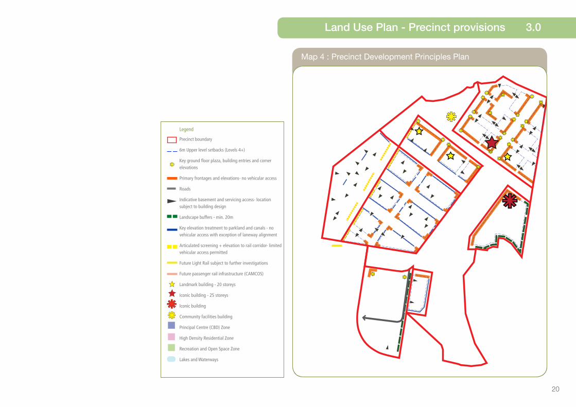
Map 4 : Precinct Development Principles Plan
Land Use Plan - Precinct provisions 3.0
Legend
Precinct boundary
6m Upper level setbacks (Levels 4+)
Key ground floor plaza, building entries and corner elevations
Primary frontages and elevations- no vehicular access
Roads
Indicative basement and servicing access- location subject to building design
Landscape buffers - min. 20m
Key elevation treatment to parkland and canals - no vehicular access with exception of laneway alignment
Articulated screening + elevation to rail corridor- limited vehicular access permitted
Future Light Rail subject to further investigations
Future passenger rail infrastructure (CAMCOS)
Landmark building - 20 storeys
Iconic building - 25 storeys
Iconic building
Community facilities building
Principal Centre (CBD) Zone
High Density Residential Zone
Recreation and Open Space Zone
Lakes and Waterways

21
h. protects ecological values and incorporates appropriate erosion and sediment control techniques; and
i. on-site stormwater management measures ensure water quality and maintain aquatic ecosystem values.
The Maroochydore Parklands Precinct will comprise five core elements:
1. Central Lakelands - A series of parkland platforms focused around the central lake.
The parklands may provide:
¾ Open kick and throw areas; ¾ Shaded picnic areas, benches
and seating; ¾ Public amenities; and ¾ Boardwalk and lake side terraces.
2. Southern Lakelands - A continuation of the central lake to the south, to create a more natural and passive area of open space. The Southern Lakelands may incorporate:
¾ Multi-use path and trail network; ¾ Fitness equipment; ¾ Play areas; ¾ Wetlands and bio-filtration
devices; ¾ Canoe and Kayak launch areas;
and ¾ Sufficient car street parking.
3. The Corso - A wide linear parkland including the realignment of Maud waterway, a wide linear park along the south bank, and integrated plaza spaces.
The Corso may deliver:
¾ Plaza areas interfacing with Maud waterway;
¾ Shaded picnic areas and seating; ¾ Public amenities; and ¾ Boardwalks and promenades.
4. Civic Plaza - A highly accessible community gathering area, including library, play space, open lawns and pathway connections. The Plaza may include:
¾ Library; ¾ Durable plaza / public square;
Children’s play space; ¾ Public art and sculpture court; ¾ Open lawns; and ¾ Planted buffer to adjoining
residential.
3.6 - Precinct 1 - Maroochydore Parklands Precinct
Precinct Intent
The Maroochydore Parklands Precinct is intended to become a major community and regional destination for informal recreation, respite and community activities.
It will comprise a major linear parkland and lake. It will be a high quality urban park with open lawns, shaded picnic areas, play equipment, public amenities and passive recreation uses.
Adjacent retail, commercial, community and residential uses will address and overlook the park; providing surveillance, address and ownership of this key public open space asset.
Precinct Outcomes
Development within the Maroochydore Parklands Precinct achieves the following:
a. comprises urban open space providing the ‘Corso’ green spine, central parklands and lakelands centre piece in the PDA;
b. includes a lake that is appropriately sized and designed to provide for stormwater management and act as a defining feature of the central parklands;
c. realigns the Maud waterway to provide a key landscape and recreational feature;
d. connects internal precincts and external land uses;
e. accommodates a civic plaza, linear recreation park, local recreation park and gathering spaces;
f. integrates with adjacent development and built form and visually, functionally and physically integrates with the Community Facilities and Entertainment Precinct;
g. incorporates landscaping with endemic species with a preference towards retaining existing remnant vegetation where possible;
3.0 Land Use Plan - Precinct provisions

22
Precinct 1 : Maroochydore Parklands Precinct5. Transit Plaza - A robust, attractive and shaded plaza space that is integrated with the transit interchange and adjacent retail uses. The Transit Plaza may provide:
¾ Durable plaza space; ¾ Shaded seating areas; ¾ Public art and sculpture court;
and ¾ Landscape gardens.
Preferred Land Uses
Preferred land uses within the Maroochydore Parklands Precinct are to include:
• Park• Waterway• Landing
Ancillary convenience uses may include:
• Food and drink outlet
The Maroochydore Parklands Precinct provides for recreational lease/ hire facilities and public berthing facility for water craft.
Legend
PDA Boundary
Precinct Boundary
Recreation and Open Space Zone
Lakes and Waterways
Community Facilities Building
Roads
Future light rail, subject to further investigation
Future passenger rail infrastructure (CAMCOS)
Land Use Plan - Precinct provisions 3.0

23
Precinct 1 Maroochydore Parklands Precinct: Levels of Assessment
Column 3 – PDA assessable development
Column 1
Exempt development
Column 2
PDA self assessable development
Column 3A
Permissible development
Column 3B
Prohibited development
Development referred to in Schedule 1. Nil All development, including development not defined in Schedule 2, other than development mentioned in Schedule 1 or Column 1, 2 or 3B.
1. Extractive industry
2. High impact industry
3. Low impact industry
4. Medium impact industry
5. Special industry
6. Warehouse
7. Agricultural supplies store
8. Animal husbandry
9. Cropping
10. Intensive animal industry
3.0 Land Use Plan - Precinct provisions

24
3.7 - Precinct 2 - Community Facilities and Entertainment Precinct
Precinct Intent
The Community Facilities and Entertainment Precinct is intended to deliver a new entertainment and convention focus for Maroochydore and the Sunshine Coast.
Located on the edge of the central lake and the new city centre, this precinct will accommodate regional level community infrastructure for major entertainment, tourism and community facilities.
Integrated with high quality landscape and waterway treatments, public art and plaza spaces, the built form will reflect contemporary, sub-tropical and coastal architecture, whilst incorporating sustainability and energy efficiency targets.
Precinct Outcomes
Development within the Community Facilities and Entertainment Precinct achieves the following:
a. community facilities and infrastructure consisting of a key civic or entertainment development and supporting uses, local community centre, meeting spaces, administration space, urban open space infrastructure; and
b. a built form which frames and activates the forecourt and the other elements of the adjoining urban open space to create a human scale and pedestrian friendly environment.
Development in the Community Facilities and Entertainment Precinct is to:
a. align development along the Maud waterway and provide for wide shaded pathways;
b. provide an iconic building in accordance with iconic building heights and design standards for key locations;
c. provide high quality, durable and robust public open spaces and landscape treatment;
d. incorporate public art and sculptural elements;
e. provide wide pedestrian promenades and forecourt connecting to the southern part of the Maroochydore Parklands Precinct and the Corso;
f. provides bridge concourses to connect the facility frontages to the Main Street;
g. provides a wide pedestrian promenade and forecourt adjacent to the facility, alongside or over the central lake;
h. provides landscape plazas for public access and open spaces for community use; and
i. incorporates a landscaped buffer to provide separation between the community and entertainment facility and adjoining existing residential development.
Preferred Land Uses
Preferred Land Uses within the Community Facilities and Entertainment Precinct include:
• Major recreation and entertainment facility
• Community Use (including: Public Amphitheatre and Civic Plaza/gathering place).
• Hotel
• Office
• Shop
• Food and Drink Outlet
• Market
• Parking Station
Land Use Plan - Precinct provisions 3.0

25
Precinct 2 Community Facilities and Entertainment Precinct: Levels of Assessment
Column 3 – PDA assessable development
Column 1
Exempt development
Column 2
PDA self assessable development
Column 3A
Permissible development
Column 3B
Prohibited development
Development referred to in Schedule 1. Nil All development, including development not defined in Schedule 2, other than development mentioned in Schedule 1 or Column 1, 2 or 3B.
1. Extractive industry
2. High impact industry
3. Low impact industry
4. Medium impact industry
5. Special industry
6. Warehouse
7. Agricultural supplies store
8. Animal husbandry
9. Cropping
10. Intensive animal industry
3.0 Land Use Plan - Precinct provisions

26
Precinct 2: Community Facilities and Entertainment Precinct
Legend
PDA Boundary
Precinct Boundary
6m Upper level setbacks (Levels 4+)
Primary frontages and elevations- no vehicular access
Landscape buffers- min. 20m
Iconic Building
Principal Centre (CBD) Zone
Recreation and Open Space Zone
Land Use Plan - Precinct provisions 3.0
27
3.8 - Precinct 3 - Retail Core Precinct
Precinct Intent
The Retail Core Precinct is intended to be the primary mixed use retail core within the PDA, capitalising on the proposed transit infrastructure and proximity to existing retail activity in areas adjoining the PDA.
Precinct Outcomes
Development within the Retail Core Precinct achieves the following:
a. a high intensity mixed-use retail core that accommodates the highest concentration of retail and office floor space within the PDA;
b. short term or permanent residential accommodation or office uses as part of mixed-use buildings located on floor levels above any retail floors;
c. lots that are a type and scale consistent with the desired built form outcomes of the precinct;
d. primarily transit orientated development optimising access to public transit convenience (CAMCOS, light rail, cycle ways etc);
e. active retail frontages;
f. high quality, sub-tropical landscape design;
g. public art and gateway elements;
h. car parking sleeved or screened from street view;
i. quality public spaces and streets with a high level of pedestrian and cyclist accessibility, and connection to surrounding precincts;
j. maximum yields for this precinct are expected to be in the order of 14:
¾ Retail - 40,000 m2 GFA; and
¾ Commercial - 60,000 m2 GFA; and
k. approximately 600 residential dwellings.
Buildings provide for:
a. sculptural and articulated architectural building design;
b. 1-3 storey podium height;
c. up to 15 storey building height (except in 8 storey height restricted parcels) in compliance with Map 5 (Maximum Building Heights);
d. opportunity for a landmark building up to 25 storeys in height, that responds to key locations in compliance with Map 5 (Maximum Building Heights); and
e. opportunity for a landmark building up to 20 storeys in height that responds to key locations in compliance with Map 5 (Maximum Building Heights).
Preferred Land Uses
Preferred Land Uses within the Retail Core Precinct include:
• Shop
• Shopping Centre
• Office
• Hotel
• Multiple Dwelling
• Market
• Indoor Sport and Recreation
• Food and Drink Outlet
• Theatre
• Short-term accommodation
• Place of Worship
14 A Precinct Plan that seeks to exceed the maximum
development yield must be accompanied by:
(a) an infrastructure network analysis that demonstrates
that the additional yield will not compromise the planned
infrastructure networks for the PDA, in particular the planned
transport infrastructure network; and
(b) an economic impact assessment for additional retail
proposed for precincts other than Precinct 3 (Retail Core) that
demonstrates:
(i) how the proposed additional area will complement and
not compromise the Maroochydore Principal Regional
Activity Centre and the Sunshine Coast Centres Hierarchy;
and
(ii) that the additional yield provides for increased
employment opportunities within the PDA.
3.0 Land Use Plan - Precinct provisions

28
Precinct 3: Retail Core Precinct
Legend
PDA Boundary
Precinct Boundary
Principal Centre (CBD) Zone
Recreation and Open Space Zone
6m Upper level setbacks (Levels 4+)
Key ground floor plaza, building entries and corner elevations
Primary frontages and elevations- no vehicular access
Indicative basement and servicing access- location subject to building design
Future Light Rail subject to further investigations
Roads
Landmark building- 20 storeys
Landmark building- 25 storeys
Land Use Plan - Precinct provisions 3.0
29
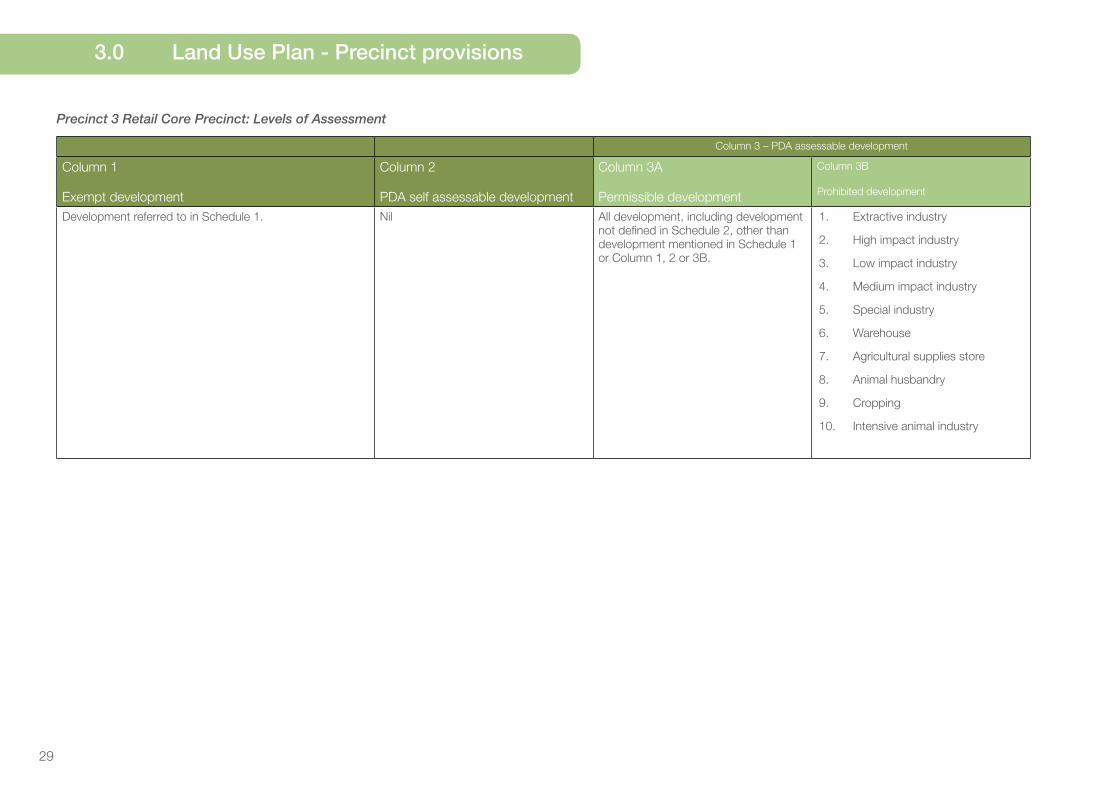
Precinct 3 Retail Core Precinct: Levels of Assessment
Column 3 – PDA assessable development
Column 1
Exempt development
Column 2
PDA self assessable development
Column 3A
Permissible development
Column 3B
Prohibited development
Development referred to in Schedule 1. Nil All development, including development not defined in Schedule 2, other than development mentioned in Schedule 1 or Column 1, 2 or 3B.
1. Extractive industry
2. High impact industry
3. Low impact industry
4. Medium impact industry
5. Special industry
6. Warehouse
7. Agricultural supplies store
8. Animal husbandry
9. Cropping
10. Intensive animal industry
3.0 Land Use Plan - Precinct provisions

30
3.9 - Precinct 4 - Commercial Precinct
Precinct Intent
The Commercial Precinct is intended for predominantly medium grade commercial and office building development, along with a limited amount of larger format retail.
Precinct Outcomes
Development within the Commercial Precinct achieves the following:
a. medium intensity commercial development consisting of office based commercial uses and entertainment uses that provide a key employment hub for the Sunshine Coast region;
b. integration with the transit plaza and the transit station and interchange (CAMCOS); Retail Core Precinct; regional shopping centre (Sunshine Plaza); and Plaza Parade;
c. a central public parking facility;
d. a site for a communications and technology data centre;
e. lane way connections/shared zone streets around linear parks;
f. maximum development yields for this precinct are expected to be in the order of 15:
¾ Retail - 3,900 m2 GFA; and
¾ Commercial - 50,000 m2 GFA; and
g. development does not provide for residential uses, other than caretakers accommodation.
The built form is to:
a. sleeve or screen car parking from street view;
b. provide high quality screening or cladding of eastern interface with the future rail corridor;
c. provide a high degree of landscape, lighting and pedestrian access along the railway frontage and western street to activate the street level; and
d. respond to corner elevations and frontages to provide building entries and articulated building form to create visual interest and activity along the rail corridor.
Preferred land uses
Preferred land uses within the Commercial Precinct include:
• Office
• Health Care Services
• Indoor Sport and Recreation
• Food and Drink Outlet
• Nightclub entertainment facility
• Hardware and Trade Supplies
• Centralised Data Centre
15 A Precinct Plan that seeks to exceed the maximum
development yield must be accompanied by:
(a) an infrastructure network analysis that demonstrates
that the additional yield will not compromise the planned
infrastructure networks for the PDA, in particular the planned
transport infrastructure network; and
(b) an economic impact assessment for additional retail
proposed for precincts other than Precinct 3 (Retail Core) that
demonstrates:
(i) how the proposed additional area will complement and
not compromise the Maroochydore Principal Regional
Activity Centre and the Sunshine Coast Centres Hierarchy;
and
(ii) that the additional yield provides for increased
employment opportunities within the PDA.
Land Use Plan - Precinct provisions 3.0

31
Precinct 4 Commercial Precinct: Levels of Assessment
Column 3 – PDA assessable development
Column 1
Exempt development
Column 2
PDA self assessable development
Column 3A
Permissible development
Column 3B
Prohibited development
Development referred to in Schedule 1. Nil All development, including development not defined in Schedule 2, other than development mentioned in Schedule 1 or Column 1, 2 or 3B.
1. Extractive industry
2. High impact industry
3. Low impact industry
4. Medium impact industry
5. Special industry
6. Warehouse
7. Agricultural supplies store
8. Animal husbandry
9. Cropping
10. Intensive animal industry
3.0 Land Use Plan - Precinct provisions

32
Precinct 4: Commercial Precinct
Legend
PDA Boundary
Precinct Boundary
Principal Centre (CBD) Zone
Recreation and Open Space Zone
Key elevation treatment to parkland and canals- no vehicular access with exception of laneway alignment
Indicative basement and servicing access- location subject to building design
Articulated screening + elevation to rail corridor- limited vehicular access permitted
Future passenger rail infrastructure (CAMCOS)
Roads
Land Use Plan - Precinct provisions 3.0
33
3.10 - Precinct 5 - Main Street South Precinct
Precinct Intent
The Main Street South Precinct is intended to provide a residential village environment oriented along the Main Street Boulevard with lower intensity of commercial activity, lower building heights and predominantly residential uses. Ground floor retail and commercial tenancies in key locations, will be encouraged to create activity at street level.
Development will optimise views to, and access along linear open space parklands and waterways. The amenity of the Main Street South Precinct has a clear connection to the Maroochydore Parklands Precinct to the east.
The streetscape, landscape and architectural intent and outcomes will relate to the Retail Core Precinct, aiming to achieve high quality, contemporary and coastal architectural responses.
Precinct Outcomes
Development within the Main Street South Precinct achieves the following:
a. mixed-use residential and commercial development incorporating predominantly permanent residential uses;
b. some offices and retail development;
c. maximum development yields for this precinct are expected to be in the order of 16:
¾ Retail - 6,000 m2 GFA; and
¾ Commercial - 20,000 m2 GFA; and
d. approximately 1,000 residential dwellings.
Built form is to:
a. provide sculptural and articulated architectural building design;
b. provide high quality sub-tropical landscape design;
c. create active interfaces and frontages to linear parklands and waterway areas;
d. provide primary frontages and elevations where nominated;
e. incorporate public art and gateway elements, upon entering the precinct from the south;
f. ensure that carparking is sleeved or screened from street view; and
g. provide a 2-3 storey podium height and up to 15 storey building height in compliance with Map 5 (Maximum Building Heights).
Preferred Land Uses
Preferred land uses within the Main Street South Precinct includes:
• Shop
• Office
• Hotel
• Indoor Sport and Recreation
• Food and Drink Outlet
• Multiple dwelling
16 A Precinct Plan that seeks to exceed the maximum
development yield must be accompanied by:
(a) an infrastructure network analysis that demonstrates
that the additional yield will not compromise the planned
infrastructure networks for the PDA, in particular the planned
transport infrastructure network; and
(b) an economic impact assessment for additional retail
proposed for precincts other than Precinct 3 (Retail Core) that
demonstrates:
(i) how the proposed additional area will complement and
not compromise the Maroochydore Principal Regional
Activity Centre and the Sunshine Coast Centres Hierarchy;
and
(ii) that the additional yield provides for increased
employment opportunities within the PDA.
3.0 Land Use Plan - Precinct provisions

34
Precinct 5: Main Street South Precinct
Legend
PDA Boundary
Precinct Boundary
Principal Centre (CBD) Zone
Recreation and Open Space Zone
Lakes and Waterways
6m Upper level setbacks (Levels 4+)
Primary frontages and elevations- no vehicular access
Roads
Key elevation treatment to parkland and canals- no vehicular access with exception of laneway alignment
Indicative basement and servicing access- location subject to building design
Articulated screening + elevation to rail corridor-
limited vehicular access permitted
Land Use Plan - Precinct provisions 3.0

35
Precinct 5 Main Street South Precinct: Levels of Assessment
Column 3 – PDA assessable development
Column 1
Exempt development
Column 2
PDA self assessable development
Column 3A
Permissible development
Column 3B
Prohibited development
Development referred to in Schedule 1. Nil All development, including development not defined in Schedule 2, other than development mentioned in Schedule 1 or Column 1, 2 or 3B.
1. Extractive industry
2. High impact industry
3. Low impact industry
4. Medium impact industry
5. Special industry
6. Warehouse
7. Agricultural supplies store
8. Animal husbandry
9. Cropping
10. Intensive animal industry
3.0 Land Use Plan - Precinct provisions

36
3.11 - Precinct 6 - Main Street North Precinct
Precinct Intent
The Main Street North Precinct is intended to be a ‘frame’ to the Retail Core Precinct and will deliver predominantly a mix of retail, commercial and residential uses.
Precinct Outcomes
Development within the Main Street North Precinct achieves the following:
a. high intensity residential uses with some capacity for commercial and retail uses at ground and podium;
b. integration with the transit plaza and the transit station and interchange (CAMCOS), other bicycle and pedestrian infrastructure, the urban open space infrastructure in the Maroochydore Parklands Precinct, Retail Core Precinct and Commercial Precinct;
c. maximum development yields for this precinct are expected to be in the order of 17:
¾ Retail - 15,000 m2 GFA; and
¾ Commercial - 20,000 m2 GFA; and
d. approximately 250 residential dwellings.
Development in the Main Street North Precinct is to:
a. provide for uses such as cafes and retail to activate ground floor frontages;
b. create gateway and feature building design responses to corner parcels;
c. deliver residential uses to provide balconies and building entries addressing external roads;
d. ensure car parking is sleeved or screened from street view;
e. encourage semi-basements (preferred to ground floor car parking) to allow balconies to address the street, but with some grade change for privacy and separation;
f. up to 15 storey building heights in compliance with Map 5 (Maximum Building Heights); and
g. provide opportunity for buildings up to 20 storeys in height, that respond to key locations in compliance with Map 5 (Maximum Building Heights).
Preferred land uses
Preferred Land Uses within the Main Street North Precinct include:
• Shop
• Office
• Hotel
• Indoor Sport and Recreation
• Food and Drink Outlet
• Multiple dwelling
17 A Precinct Plan that seeks to exceed the maximum
development yield must be accompanied by:
(a) an infrastructure network analysis that demonstrates
that the additional yield will not compromise the planned
infrastructure networks for the PDA, in particular the planned
transport infrastructure network; and
(b) an economic impact assessment for additional retail
proposed for precincts other than Precinct 3 (Retail Core) that
demonstrates:
(i) how the proposed additional area will complement and
not compromise the Maroochydore Principal Regional
Activity Centre and the Sunshine Coast Centres Hierarchy;
and
(ii) that the additional yield provides for increased
employment opportunities within the PDA.
Land Use Plan - Precinct provisions 3.0

37
Precinct 6 Main Street North Precinct: Levels of Assessment
Column 3 – PDA assessable development
Column 1
Exempt development
Column 2
PDA self assessable development
Column 3A
Permissible development
Column 3B
Prohibited development
Development referred to in Schedule 1. Nil All development, including development not defined in Schedule 2, other than development mentioned in Schedule 1 or Column 1, 2 or 3B.
1. Extractive industry
2. High impact industry
3. Low impact industry
4. Medium impact industry
5. Special industry
6. Warehouse
7. Agricultural supplies store
8. Animal husbandry
9. Cropping
10. Intensive animal industry
3.0 Land Use Plan - Precinct provisions

38
Precinct 6: Main Street North Precinct
Legend
PDA Boundary
Precinct Boundary
Principal Centre (CBD) Zone
Recreation and Open Space Zone
Lakes and Waterways
6m Upper level setbacks (Levels 4+)
Key ground floor plaza, building entries and corner elevations
Primary frontages and elevations- no vehicular access
Roads
Key elevation treatment to parkland and canals- no vehicular access with exception of lane way alignment
Articulated screening + elevation to rail corridor- limited vehicular access permitted
Indicative basement and servicing access- location subject to building design
Landmark building - 20 storeys
Land Use Plan - Precinct provisions 3.0

39
3.12 - Precinct 7 - Residential Precinct
Precinct Intent
The Residential Precinct is intended for predominantly residential uses that overlook the southern lake lands.
It will comprise up to 8 storey residential buildings in compliance with Map 5 (Maximum Building Heights), achieving medium and high density residential uses and capitalising on the amenity and character of the southern lakelands.
Precinct Outcomes
Development within the Residential Precinct achieves the following:
a. predominantly medium and high intensity residential uses with some limited ground floor convenience retail and cafe uses; and
b. maximum development yields for this precinct are expected to be in the order of 18:
¾ Retail - up to 100m2 GFA; and
¾ approximately 200 residential dwellings.
Buildings and uses in the Residential Precinct:
a. include gateway and feature building design responses to the southern arrival road frontage and vista;
b. locate ground floor retail uses to overlook the lake; and
c. ensure car parking is sleeved or screened from street view.
Preferred land uses
Preferred land uses in the Residential Precinct include:
• Multiple dwelling
• Residential care facility
• Food and drink outlet
3.0 Land Use Plan - Precinct provisions
18 A Precinct Plan that seeks to exceed the maximum
development yield must be accompanied by:
(a) an infrastructure network analysis that demonstrates
that the additional yield will not compromise the planned
infrastructure networks for the PDA, in particular the planned
transport infrastructure network; and
(b) an economic impact assessment for additional retail
proposed for precincts other than Precinct 3 (Retail Core) that
demonstrates:
(i) how the proposed additional area will complement and
not compromise the Maroochydore Principal Regional
Activity Centre and the Sunshine Coast Centres Hierarchy;
and
(ii) that the additional yield provides for increased
employment opportunities within the PDA.

40
Precinct 7: Residential Precinct
Legend
PDA Boundary
Precinct Boundary
High Density Residential Zone
Recreation and Open Space Zone
6m Upper level setbacks (Levels 4+)
Primary frontages and elevations- no vehicular access
Road
Indicative basement and servicing access- location subject to building design
Key elevation treatment to parkland and canals- no vehicular access with exception of lane way alignment
Land Use Plan - Precinct provisions 3.0

41
Precinct 7 Residential Precinct: Levels of Assessment
Column 3 – PDA assessable development
Column 1
Exempt development
Column 2
PDA self assessable development
Column 3A
Permissible development
Column 3B
Prohibited development
Development referred to in Schedule 1. Nil All development, including development not defined in Schedule 2, other than development mentioned in Schedule 1 or Column 1, 2 or 3B.
1. Extractive industry
2. High impact industry
3. Low impact industry
4. Medium impact industry
5. Special industry
6. Warehouse
7. Agricultural supplies store
8. Animal husbandry
9. Cropping
10. Intensive animal industry
3.0 Land Use Plan - Precinct provisions

42
3.13 Precinct 8 - Dalton Drive Precinct
Precinct Intent
The Dalton Drive Precinct is intended to accommodate a range of land uses which deliver a scale, character, intensity and function of development suited to the periphery of the new city centre and compatible with existing adjoining uses.
Precinct Outcomes
Development within the Dalton Drive Precinct achieves the following:
a. recognises the role of Dalton Drive as a primary arrival corridor to the new city centre and provide high quality built form and extensive landscaping to these key frontages;
b. provides for Dalton Drive to be established as a landscaped boulevard incorporating public transport infrastructure, wide pedestrian paths, generous established landscaped verges and medians within the road reserve and limited lot access for buildings;
c. activates the intersection of Dalton Drive and the proposed new entry roads as a key gateway site into the new city centre;
d. provides a primary active frontage treatment to the north west corner of the precinct;
e. designs car parking areas to be sensitively positioned to protect amenity and maintain a significant landscaped urban streetscape;
f. provide a landscaped interface between the rear of buildings and the Residential Precinct in order to protect the amenity of future uses; and
g. maximum development yields for this precinct are expected to be in the order of 18:
¾ Retail - 10,000 m2 GFA; and
¾ Commercial - 15,000 m2 GFA; and
h. medium density residential dwellings.
Preferred land uses
Preferred land uses in the Dalton Drive Precinct are:
• Food and drink outlet
• Health care services
• Office
• Showroom / Hardware and trade supplies
Ancillary development within the Dalton Drive Precinct may also include:
• Child care centre
• Community use
• Limited multiple dwellings
• Service station
18 A Precinct Plan that seeks to exceed the maximum
development yield must be accompanied by:
(a) an infrastructure network analysis that demonstrates
that the additional yield will not compromise the planned
infrastructure networks for the PDA, in particular the planned
transport infrastructure network; and
(b) an economic impact assessment for additional retail
proposed for precincts other than Precinct 3 (Retail Core) that
demonstrates:
(i) how the proposed additional area will complement and
not compromise the Maroochydore Principal Regional
Activity Centre and the Sunshine Coast Centres Hierarchy;
and
(ii) that the additional yield provides for increased
employment opportunities within the PDA.
Land Use Plan - Precinct provisions 3.0

43
Precinct 8 Dalton Drive Precinct: Levels of Assessment
Column 3 – PDA assessable development
Column 1
Exempt development
Column 2
PDA self assessable development
Column 3A
Permissible development
Column 3B
Prohibited development
Development referred to in Schedule 1. Nil All development, including development
not defined in Schedule 2, other than
development mentioned in Schedule 1 or
Column 1, 2 or 3B.
1. Extractive industry
2. High impact industry
3. Low impact industry
4. Medium impact industry
5. Special industry
6. Warehouse
7. Agricultural supplies store
8. Animal husbandry
9. Cropping
10. Intensive animal industry
3.0 Land Use Plan - Precinct provisions

44
Precinct 8 : Dalton Drive Precinct
Legend
PDA Boundary
Precinct Boundary
Principal Centre (CBD) Zone
Key ground floor plaza, building entries and corner elevations
Indicative basement and servicing access- location subject to building design
Roads
Landscape buffers - min. 20m
Primary frontages and elevations - no vehicular access
Land Use Plan - Precinct provisions 3.0

45
Map 5: Maximum Building Heights
3.0 Land Use Plan - Maps
Legend
max. 8 storeys- plot ratio of 1.5
max. 8 storeys- plot ratio of 2
max. 15 storeys- plot ratio of 3
max. 15 storeys- plot ratio of 4
max. 20 storeys- plot ratio of 5
max. 25 storeys- plot ratio of 6
Legend
max. 6 storeys and no more than 25m - plot ratio of 2
max. 8 storeys and no more than 25m - plot ratio of 1.5
max. 8 storeys and no more than 25m - plot ratio of 2
max. 15 storeys and no more than 50m - plot ratio of 3
max. 15 storeys and no more than 50m - plot ratio of 4
max. 8 storeys and no more than 25m
max. 20 storeys and no more than 66m - plot ratio of 5
max. 25 storeys and no more than 83.5m - plot ratio of 5
Iconic building

46
Map 6: Road Hierarchy Plan
Land Use Plan - Maps 3.0
Mar
ooch
y Bl
vd.
Legend Minimum
Reserve
Width
Lane
Width
Verge
Width
Median Cycle
Lane
Car
Parking
Public
Transit
1. Corso Esplanade 27.5m 2x 3.5m 6.5m - - varies Bus
2. Town Centre Boulevard 40m 4 x 3.5m 4m 3m 2 x 1.5m restricted Bus and
Light Rail
3. Town Centre Avenue 20m 2 x 3.5m 6.5m - - both sides Bus and
Light Rail
4. Main Street Boulevard 25m 4 x 3.5m 6.5m 3m - restricted Bus
5. Residential Avenues 19m 2 x 3m 6.5m - - one side -
6. Park Esplanade 28m 4 x 3.5m 4m 3m 2 x 1.5m restricted Bus
7. Railway Street varies varies varies varies - one side Bus
8. Residential Parkway 14.5 2 x 3m 6.5m/2m - - one side -
9. Residential Waterway 15.5 2 x 3m 6.5m/3m - - one side -
10. Laneways 8m 2 x 2.5m 1.5m - - in lot -
Major Signalised Intersections
Potential light rail subject to further investigations
Future passenger rail infrastructure (CAMCOS)
Note: All dimensions are indicative and subject to detailed engineering design

47
4. Main Street Boulevard
2. Town Centre Boulevard1. Corso Esplanade
27.5m 26.5m
15m wide ‘Corso’ Civic Parkland providing a
wide landscaped connection between Plaza
Parade and Maud Street
Maud Waterway (20m wide)
8m wide light rail corridor along
Maud Waterway
6.56.5 78520147
3. Town Centre Avenues
Road Hierarchy Profiles
3.0 Land Use Plan - Road Hierarchy Profiles
Town Centre Avenue + Lightrail
Landscaped pedestrian footpath to
each side of the street including rest
seating, public art and opportunities
for street side dining.
On street parking provision
Avenue style planting to reinforce the
sub-tropical and parkland character of the
city centre
20m
76.5 6.5
25m
Potential grade separation to ground
floor residential units to provide privacy
whilst maintaining surveillance
Opportunity for ground floor retail
tenancies at key corners or high
amenity frontages
Highly landscape road profile,
including central median
4 47 3 7
30m
Tall columnar trees (i.e. Kauri Pines) to
provide vertical scale to offset central
boulevard building heights, within
median
40m
6m wide verge to provide wide
pedestrian footpath and opportunities
for street side dining, public art and
plaza areas
Light rail, cycle ways and wide
landscaped verge providing activity,
visual interest and connectivity
34 7 8
1.5
7 8

48
Land Use Plan - Road Hierarchy Profiles 3.0
5. Residential Avenues
Landscaped pedestrian footpath to each side of
the street including rest seating, public art and
opportunities for street side dining.
Avenue style planting to reinforce a
sub-tropical and parkland character
19m
66.5 6.5
6. Park Esplanade
Wide multi use pathway as a feature pedestrian and cyclist
connection on the edge of the central parkOpportunity for street side
dining and boutique retail
tenancies at street levelCentral median provides pedestrian refuge islands at regular
intervals allowing safer road crossings
28m
34 7 4
1.5
7
Landscape buffer to improve
amenity and outlook from
adjoining commercial buildings
Landscaped verges to improve
visual amenity to adjoining
addresses and partially
mask view the elevated rail
infrastructure.
25-40m approx.
7. Railway Street

49
3.0 Land Use Plan - Road Hierarchy Profiles
10. Laneways
Service and access to one side
of lane way
Potential car park, landscape and
small courtyards to ‘open up’
lane way
8-10m approx.
8. Residential Parkway
9. Residential Waterway
15.5m
2566.5 3
Potential laneway/ service
access if required
14.5m
25266.5
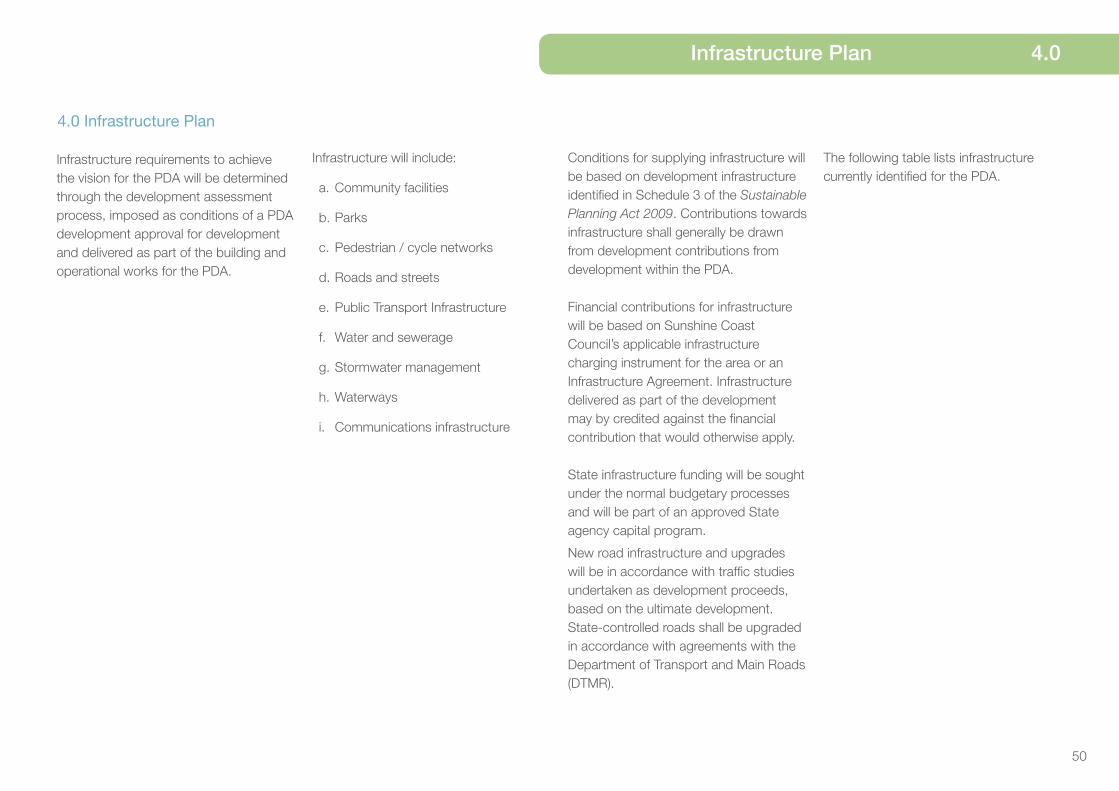
50
Infrastructure Plan 4.0
4.0 Infrastructure Plan
Infrastructure requirements to achieve the vision for the PDA will be determined through the development assessment process, imposed as conditions of a PDA development approval for development and delivered as part of the building and operational works for the PDA.
Infrastructure will include:
a. Community facilities
b. Parks
c. Pedestrian / cycle networks
d. Roads and streets
e. Public Transport Infrastructure
f. Water and sewerage
g. Stormwater management
h. Waterways
i. Communications infrastructure
Conditions for supplying infrastructure will be based on development infrastructure identified in Schedule 3 of the Sustainable Planning Act 2009. Contributions towards infrastructure shall generally be drawn from development contributions from development within the PDA.
Financial contributions for infrastructure will be based on Sunshine Coast Council’s applicable infrastructure charging instrument for the area or an Infrastructure Agreement. Infrastructure delivered as part of the development may by credited against the financial contribution that would otherwise apply.
State infrastructure funding will be sought under the normal budgetary processes and will be part of an approved State agency capital program.
New road infrastructure and upgrades will be in accordance with traffic studies undertaken as development proceeds, based on the ultimate development. State-controlled roads shall be upgraded in accordance with agreements with the Department of Transport and Main Roads (DTMR).
The following table lists infrastructure currently identified for the PDA.

51
Infrastructure Description of Works
Community Facilities Infrastructure
Land for a new Regional Library to be located within the Civic Plaza (Maroochydore Parklands Precinct). Co-location with other community facilities infrastructure will be considered.
Provision of 3.2 ha of land for a new regional entertainment, exhibition and convention centre within the Community Facilities and Entertainment Precinct.
New public amphitheatre within the Community Facilities and Entertainment Precinct.
Urban Open Space and Recreation Infrastructure
New public promenade (“The Corso”) including the realignment and improvement to the Maud waterway.
New public Transit Plaza adjoining the proposed Transit Interchange within the Maroochydore Parklands Precinct.
New Civic Plaza within the Maroochydore Parklands Precinct.
New urban open space waterways comprising an 8.4 ha central lake and waterway corridors within the Maroochydore Parklands Precinct.
New Major Linear recreation park within the Maroochydore Parklands Precinct.
New Local recreation park within the Maroochydore Parklands Precinct.
Bicycle and Pedestrian Infrastructure
New bicycle and pedestrian infrastructure within the road transport infrastructure network.
New bicycle and pedestrian infrastructure within the Maroochydore Parklands Precinct providing safe and convenient pedestrian and bicycle access within the precinct and linking to existing external bicycle and pedestrian networks.
Road Transport Infrastructure
New road transport infrastructure (within and outside the PDA boundary) in compliance with Map 6 (Road Hierarchy Plan) and the Road Hierarchy Profiles.
Accommodate potential future light rail infrastructure with in the proposed Main Street Boulevard Road.
Public Parking Infrastructure
Land for public car parking facilities to be provided in consolidated locations within the PDA and located to minimise traffic circulation and promote ‘park and walk’ opportunities.
4.0 Infrastructure Plan

52
Infrastructure Plan 4.0
Infrastructure Description of Works
Public Transport Infrastructure
Protection of land for the CAMCOS rail corridor and interchange.
Water and Sewerage Infrastructure
Water and sewer networks will be upgraded at the time of developments being undertaken and will be provided in accordance with the Water and Sewer Assessment Report undertaken by Cardno as supporting documentation to the development scheme. Any development in excess of the planned network demand, as determined by the network operator at the time of development, may trigger an assessment of the surrounding infrastructure to determine any requirement for surrounding infrastructure upgrades.
New sewer pump station to be provided in accordance with Water and Sewer Assessment Report undertaken by Cardno as supporting documentation to the development scheme.
New major sewer pressure main to be provided in accordance with Water and Sewer Assessment Report undertaken by Cardno as supporting documentation to the development scheme.
Stormwater Management Infrastructure
New stormwater management infrastructure comprising a 8.4 ha waterway and waterway corridors.
Water recirculation system for the 8.4 ha waterway.
Telecommunications Infrastructure
New state of the art telecommunications infrastructure to service the development.
Site for a centralised communications and data centre.

1.0 Introduction
53
5.0 Implementation Strategy
The Economic Development Act 2012 (the Act) requires a development scheme to include an Implementation Strategy to “achieve the main purposes of the Act for this area, to the extent that they are not achieved by the Land Use Plan or the plan for infrastructure”.
The Implementation Strategy for the Maroochydore City Centre PDA Development Scheme (the scheme) fulfils this requirement by identifying a suite of actions that support the achievement of the vision for the PDA and support the delivery of economic development and development for community purposes within the PDA.
This strategy focuses on:
1. Delivery of the Maroochydore City Centre - land acquisitions and business attraction.
2. Delivery of key transport corridors - including passenger rail and light rail - to service the new city centre and the broader Maroochydore city, in accordance with State and Local Government commitments and resourcing.
3. Construction of infrastructure to mitigate the impact of flooding.
4. Construction of major parks and public open spaces.

54
Implementation Strategy 5.0
Element Measure Actions
Delivery of the Maroochydore City Centre - land acquisitions and business attraction
Catalyst development occurs in the PDA.
• Acquisition of identified sites external to the PDA for the purposes of delivering access, movement and network infrastructure that is integrated and efficient and encourages investment and development in the new city centre.
• Delivery of early works infrastructure to prepare the PDA for development and streamline the delivery process for preferred development.
• Establish a coordinated marketing plan and brand for the Maroochydore city centre.
• Develop an economic development investment strategy focussed on coordinating investment attraction and diversifying employment opportunities while supporting organic business growth.
• Establish a governance and management framework to progress the delivery, marketing and sales phases of the Maroochydore City Centre.
Delivery of key transport corridors
Land for key transport corridors is available for the construction of passenger and light rail infrastructure.
• Land is retained in Council ownership to accommodate future transport corridors.
• Interim land uses, whilst permitted, are approved with conditions to ensure land availability as and when required.
• Development adjoining identified key transport corridors is undertaken to respond to potential rail infrastructure and servicing requirements.
Construction of infrastructure to mitigate the impact of flooding
Progressive delivery of flood mitigation infrastructure to ensure flood immunity
• Land required for construction of major lakes and drainage system remains in Council control until flood mitigation infrastructure is completed.
• Flood mitigation infrastructure is built in accordance with timing and design requirements established in a Maroochydore Central Precinct Flood Study.
Construction of major parks and public open space
Progressive delivery of parklands and open space will be aligned with staged construction of adjoining infrastructure.
• Create a project staging plan to identify parkland and open spaces to be built on a staged basis.

55
6.0 Schedules
Schedule 1: Exempt Development Development prescribed in Schedule 4 of the Sustainable Planning Regulation 2009, other than Table 2, item 2 and Table 5, item 14.
Building Work
Minor building and demolition work.
Carrying out building work associated with a material change of use that is PDA exempt or self-assessable development.
Carrying out building work associated with an approved material change of use.
Material change of use of premises
Making a material change of use of premises for a Park.
Reconfiguring a lot
Subdivision involving road widening and truncations required as a condition of development approval.
Operational work
Erecting no more than one (1) satellite dish on premises, where the satellite dish has no dimension greater than 1.8 metres.
Filling or excavation where:
(a) not exceeding 50m3 in volume or
(b) top dressing to a depth of less than 100 vertical millimetres from ground level.
Carrying out operational work if consistent with an approved Plan of Development (PoD).
Carrying out operational work associated with a material change of use that is PDA exempt development (excluding Park).
Carrying out operational work associated with an approved material change of use.
Carrying out operational work associated with an approved reconfiguration of a lot.
Carrying out operational work associated with the decontamination of land.
Carrying out operational work that is clearing of vegetation:
(a) other than Significant vegetation, or
(b) Significant vegetation where:
¾ the clearing is consistent with an approved PoD
¾ carried out by or on behalf of Council or a public sector entity, where the works being undertaken are authorised under a state law
¾ in accordance with the conditions of a PDA development approval for a material change of use or reconfiguring a lot.

56
Schedules 6.0
Carrying out operational work that is the placing of advertising devices that:
¾ do not exceed 5m2 for office, industrial, recreational or entertainment use
¾ are attached to a front fence or facade of a main building
¾ do not project more than 150mm from front facade or front fence
¾ are not illuminated
¾ contain the name of business or operator, the use of premises, the contact details or name and address of building and
¾ comprise no more than two signs.
Plumbing or drainage work
Carrying out plumbing or drainage work.
All aspects of development
Development undertaken for the purposes of public housing.
Development for the purposes of Community Infrastructure.
Development for a Home based business.
Development consistent with an approved PoD.

57
6.0 Schedules - Use definitions
Schedule 2: Definitions Commercial use category
Car Wash
Premises primarily used for commercially cleaning motor vehicles by an automatic or partly automatic process.
Hardware and trade supplies
Premises used for the sale, display or hire of hardware and trade supplies including household fixtures, timber, tools, paint, wallpaper, plumbing supplies and the like.
Health care services
Premises for medical, paramedical, alternative therapies and general health care and treatment of persons that involves no overnight accommodation.
Office
Premises used for an administrative, secretarial or management service or the practice of a profession, where no goods or materials are made, sold or hired and where the principal activity provides for the following:
¾ business or professional advice
¾ service of foods that are not physically on the premises
¾ office based administrative function of an organisation.
Parking Station
Premises used for parking vehicles where the parking is not ancillary to another use.
Sales office
The temporary use of premises for displaying a land parcel or buildings that can be built for sale or can be won as a prize. The use may include a caravan or relocatable dwelling or structure.
Veterinary services
Premises used for veterinary care, surgery and treatment of animals that may include provision for the short-term accommodation of the animals on the premises.
Industrial use category
Extractive industry
Premises used for the extraction and / or processing of extractive resources and associated activities, including their transportation to market.
High impact industry
Premises used for industrial activities that include the manufacturing, producing, processing, repairing, altering, recycling, storing, distributing, transferring or treating of products and have one or more of the following attributes:
¾ potential for significant impacts on sensitive land uses due to off-site emissions including aerosol, fume, particle, smoke, odour and noise
¾ potential for significant offsite impacts in the event of fire, explosion or toxic release
¾ generates high traffic flows in the context of the locality or the road network
¾ generates a significant demand on the local infrastructure network
¾ the use may involve night time and outdoor activities
¾ on-site controls are required for emissions and dangerous goods risks.
Low impact industry
Premises used for industrial activities that include the manufacturing , producing, processing, repairing, altering, recycling, storing, distributing, transferring or treating of products and have one or more the following attributes:
¾ negligible impacts on sensitive land uses due to off-site emissions including aerosol, fume, particle, smoke, odour and noise
¾ minimal traffic generation and heavy-vehicle usage
¾ demands imposed upon the local infrastructure network consistent with surrounding uses
¾ the use generally operates during the day (e.g. 7am to 6pm)
¾ offsite impacts from storage of dangerous goods are negligible
¾ the use is primarily undertaken indoors.
Medium impact industry
Premises used for industrial activities that include the manufacturing, producing, processing, repairing, altering, recycling, storing, distributing, transferring or treating of products and have one or more of the following attributes:
¾ potential for noticeable impacts on sensitive land uses due to off-site emissions including aerosol, fume, particle, smoke, odour and noise
¾ potential for noticeable offsite impacts in the event of fire, explosion or toxic release
¾ generates high traffic flows in the context of the locality or the road network

58
Schedules - Use definitions 6.0
¾ generates an elevated demand on the local infrastructure network
¾ potential for offsite impacts in the event of fire, explosion or toxic release
¾ on-site controls are required for emissions and dangerous goods risks
¾ the use is primarily undertaken indoors
¾ evening or night activities are undertaken indoors and not outdoors.
Special industry
Premises used for industrial activities that include the manufacturing, producing, processing, repairing, altering, recycling, storing, distributing, transferring or treating of products and have one or more of the following attributes:
¾ potential for extreme impacts on sensitive land uses due to off-site emissions including aerosol, fume, particle, smoke, odour and noise
¾ potential for extreme off-site impacts in the event of fire, explosion or toxic release
¾ onsite controls are required for emissions and dangerous goods risks
¾ the use generally involves night time and outdoor activities
¾ the use may involve the storage and handling of large volumes of dangerous goods
¾ requires significant separation from non-industrial uses.
Research and technology industry
Premises used for innovative and emerging technological industries involved in research design, manufacture, assembly, testing, maintenance and storage of machinery, equipment and components.
This use may include emerging industries such as energy, aerospace, and biotechnology.
Service Industry
Premises used for industrial activities that have no external air, noise or odour emissions from the site and can be suitably located with other non-industrial uses.
Warehouse
Premises used for the storage and distribution of goods, whether or not in a building, including self-storage facilities or storage yards.
The use may include sale of goods by wholesale where ancillary to storage. The use does not include retail sales from the premises or industrial uses.
Residential use category
Caretaker’s accommodation
A dwelling provided for a caretaker of a non-residential use on the same premises.
Community residence
Any dwelling used for accommodation for a maximum of six persons who require assistance or support with daily living needs, share communal spaces and who may be unrelated.
The use may include a resident support worker engaged or employed in the management of the residence.
Dual occupancy
Premises containing two dwellings on one lot (whether or not attached) for separate households.
Dwelling house
A residential use of premises for one household that contains a single dwelling.
The use includes out-buildings and works normally associated with a dwelling.
Dwelling unit
A single dwelling within a premises containing non residential use(s).
Home based business
A dwelling used for a business activity where subordinate to the residential use.
Rooming Accommodation
Premises used for the accommodation of one or more households where each resident:
¾ has a right to occupy one or more rooms
¾ does not have a right to occupy the whole of the premises in which the rooms are situated
¾ may be provided with separate facilities for private use
¾ may share communal facilities or communal space with one or more of the other residents.

59
The use may include:
¾ rooms not in the same building on-site
¾ provision of a food or other service
¾ on-site management or staff and associated accommodation.
Multiple dwelling
Premises containing three or more dwellings for separate households.
Relocatable home park
Premises used for relocatable dwellings (whether they are permanently located or not) that provides long-term residential accommodation.
The use may include a manager’s residence and office, ancillary food and drink outlet, kiosk, amenity buildings and the provision of recreation facilities for the exclusive use of residents.
Residential care facility
A residential use of premises for supervised accommodation where the use includes medical and other support facilities for residents who cannot live independently and require regular nursing or personal care.
Retirement facility
A residential use of premises for an integrated community and specifically built and designed for older people.
The use includes independent living units and may include serviced units where residents require some support with health care and daily living needs.
The use may also include a manager’s residence and office, food and drink outlet, amenity buildings, communal facilities and accommodation for staff.
Short term accommodation
Premises used to provide short term accommodation for tourists or travellers for a temporary period of time (typically not exceeding three consecutive months) and may be self contained.
The use may include a manger’s residence and office and the provision of recreation facilities for the exclusive use of visitors.
Tourist park
Premises used to provide for accommodation in caravans, self-contained cabins, tents and similar structures for the public for short term holiday purposes.
The use may include, where ancillary, a manager’s residence and office, kiosk, amenity buildings, food and drink outlet, or the provision of recreation facilities for the use of occupants of the tourist park and their visitors, and accommodation for staff.
Retail use category
Bar
Premises used primarily to sell liquor for consumption on the premises and that provides for a maximum capacity to seat sixty persons at any one time. The use may include ancillary sale of food for consumption on the premises and entertainment activities.
Bulk landscape supplies
Premises used for bulk storage and sale of landscaping and gardening supplies, which may include soil, gravel, potting mix and mulch, where the majority of materials sold from the premises are not in pre-packaged form.
Food and drink outlet
Premises used for preparation and sale of food and drink to the public for consumption on or off the site. The use may include the ancillary sale of liquor for consumption on site.
Garden Centre
Premises used primarily for the sale of plants and may include sale of gardening and landscape products and supplies where these are sold mainly in prepackaged form.
The use may include an ancillary food and drink outlet.
Market
Premises used for the sale of goods to the public on a regular basis, where goods are primarily sold from temporary structures such as stalls, booths or trestle tables. The use may include entertainment provided for the enjoyment of customers.
Outdoor sales
Premises used for the display, sale, hire or lease of products where the use is conducted wholly or predominantly outdoors and may include construction, industrial or farm plant and equipment, vehicles, boats and caravans. The use may include ancillary repair or servicing activities and sale or fitting of accessories.
Service station
Premises used for the sale of fuel including petrol, liquid petroleum gas, automotive distillate and alternative fuels.
6.0 Schedules - Use definitions

60
The use may include, where ancillary, a shop, food and drink outlet, maintenance, repair servicing and washing of vehicles, the hire of trailers, and supply of compressed air.
Shop
Premises used for the display, sale or hire of goods or the provision of personal services or betting to the public.
Shopping centre
Premises comprising two or more individual tenancies that is comprised primarily of shops and that function as an integrated complex.
Showroom
Premises used primarily for the sale of goods of a related product line that are of a size, shape or weight that requires:
¾ a large area for handling, display or storage
¾ direct vehicle access to the building by members of the public for loading and unloading items purchased or hired.
Rural use category
Agricultural supplies store
Premises used for the sale of agricultural products and supplies including agricultural chemicals and fertilisers, seeds, bulk veterinary supplies, farm clothing, saddlery, animal feed and irrigation materials.
Animal husbandry
Premises used for production of animals or animal products on either native or improved pastures or vegetation.
The use includes ancillary yards, stables and temporary holding facilities and the repair and servicing of machinery.
Animal Keeping
Premises used for boarding, breeding or training of animals. The use may include ancillary temporary or permanent holding facilities on the same site and ancillary repair and servicing of machinery.
Cropping
Premises used for growing plants or plant material for commercial purposes where dependent on the cultivation of soil.
The use includes harvesting and the storage and packing of produce and plants grown on the site and the ancillary repair and servicing of machinery used on the site.
Intensive animal industry
Premises used for the intensive production of animals or animal products in an enclosure that requires the provision of food and water either mechanically or by hand.
The use includes the ancillary storage and packing of feed and produce.
Intensive horticulture
Premises used for the intensive production of plants or plant material on imported media and located within a building or structure or where outdoors, artificial lights or containers are used.
The use includes the storage and packing of produce and plants grown on the subject site.
Wholesale nursery
Premises used for the sale of plants, but not to the general public, where the plants are grown on or adjacent to the site. The use may include sale of gardening materials where these are ancillary to the primary use.
Service, community and other uses category
Cemetery
Premises used for the interment of bodies or ashes after death.
Child care centre
Premises used for minding or care, but not residence of children.
Community care centre
Premises used to provide social support where no accommodation is provided. Medical care may be provided but is ancillary to the primary use.
Community use
Premises used for providing artistic, social or cultural facilities and community support services to the public and may include the ancillary preparation and provision of food and drink.
Crematorium
Premises used for the cremation or aquamation of bodies.
Educational establishment
Premises used for training and instruction designed to impart knowledge and develop skills.
Schedules - Use definitions 6.0

61
The use may include after school care for students or on-site student accommodation.
Emergency services
Premises used by government bodies or community organisations to provide essential emergency services or disaster management services including management support facilities for the protection of persons, property and the environment.
Funeral parlour
Premises used to arrange and conduct funerals, memorial services and the like, but do not include burial or cremation.
The use includes a mortuary and the storage and preparation of bodies for burial or cremation.
Health care services
Premises for medical, paramedical, alternative therapies and general health care and treatment of persons that involves no overnight accommodation.
Hospital
Premises used for medical or surgical care or treatment of patients whether or not involving overnight accommodation. The use may include ancillary accommodation for employees and
ancillary activities directly serving the needs of patients and visitors.
Place of worship
Premises used by an organised group for worship and religious activities.
The use may include ancillary facilities for social, educational and associated charitable activities.
Telecommunications facility
Premises used for systems that carry communications and signals by means of radio, including guided or unguided electromagnetic energy, whether such facility is manned or remotely controlled.
Utility installation
Premises used to provide the public with the following services:
¾ supply or treatment of water, hydraulic power or gas
¾ sewerage, drainage or stormwater services
¾ transport services including road, rail or water
¾ waste management facilities or
¾ network infrastructure.
The use includes maintenance and storage depots and other facilities for the operation of the use.
Veterinary services
Premises used for veterinary care, surgery and treatment of animals that may include provision for the short-term accommodation of the animals on the premises.
Sport, recreation and entertainment use category
Club
Premises used by persons associated for social, literary, political, sporting, athletic or other similar purposes for social interaction or entertainment. The use may include the ancillary preparation and services of food and drink.
Function facility
Premises used for conducting receptions or functions which may include the preparation and provision of food and liquor for consumption on site.
Hotel
Premises used primarily to sell liquor for consumption. The use may include short-term accommodation, dining and entertainment activities and facilities.
Indoor sport and recreation
Premises used for leisure, sport or recreation conducted wholly or mainly indoors.
Landing
A structure for mooring, launching, storage and retrieval of vessels where passengers embark and disembark.
Major sport, recreation and entertainment facility
Premises with large scale built facilities designed to cater for large scale events including major sporting, recreation, conference and entertainment events.
Nightclub entertainment facility
Premises used to provide entertainment, which may include cabaret, dancing and music. The use generally includes the sale of liquor and food for consumption on site.
Outdoor sport and recreation
Premises used for a recreation or sport activity that is carried on outside a building and requires areas of open space and may include ancillary works necessary for safety and sustainability.
The use may include ancillary food and drink outlet(s) and the provision of ancillary facilities or amenities conducted indoors such as changing rooms and storage facilities.
6.0 Schedules - Use definitions

62
Park
Premises accessible to the public generally for free sport, recreation and leisure, and may be used for community events or other community activities.
Facilities may include children’s playground equipment, informal sports fields and ancillary vehicle parking and other public conveniences.
Resort complex
Premises used for tourist and visitor short-term accommodation that include integrated leisure facilities including: restaurants and bars
¾ meeting and function facilities
¾ sporting and fitness facilities
¾ staff accommodation
¾ transport facilities directly associated with the tourist facility such as a ferry terminal and air services.
Theatre
Premises used for presenting movies, live entertainment or music to the public and may include provision of food and liquor for consumption on the premises.
The use may include the production of film or music, including associated
ancillary facilities, which are associated with the production, such as sound stages, wardrobe and laundry facilities, makeup facilities, set construction workshops, editing and postproduction facilities.
Tourist attraction
Premises used for providing onsite entertainment, recreation or similar facilities for the general public.
The use may include provision of food and drink for consumption on site.
Other development
Filling or excavation
Filling removal or importation of material to, from or within a lot that will change the ground level of the land.
Material change of use
As defined in the Economic Development Act 2012.
Minor building work or demolition work
An alteration, addition or extension to an existing building where the floor area including balconies is less than five per cent of the building or twenty-five square meters, whichever is lesser.
Operational work
As defined in the Economic Development Act 2012.
Substation
Premises forming part of a transmission grid or supply network under the Electricity Act 1994, and used for:
¾ converting or transforming electrical energy from one voltage to another
¾ regulating voltage in an electrical circuit
¾ controlling electrical circuits
¾ switching electrical current between circuits
¾ a switchyard or
¾ communication facilities for ‘operating works’ as defined under the Electricity Act 1994 or for workforce operational and safety communications.
Reconfiguring a lot
As defined in the Economic Development Act 2012.
Administrative definitions
Accessible housing
Housing in accordance with the applicable EDQ guideline.
Affordable housing
Housing that is appropriate to the needs of households with low to moderate incomes.
Basement
A space that is situated between one floor level and the floor level next below where no part of the space projects more than one metre above ground level.
Building
As defined in the Sustainable Planning Act 2009.
Building facade
The facade of a building that fronts the street or other public space.
Building work
As defined in the Economic Development Act 2012.
Schedules - Use definitions 6.0

63
Building height
If specified:
(a) in metres, the vertical distance between the ground level and the highest point of the building roof (apex) or parapet at any point, but not including load-bearing antenna, aerial, chimney, flagpole or the like
(b) in storeys, the number of storeys above ground level or
(c) in both metres and storeys, both (a) and (b) apply.
Contaminated Land Register
As defined in the Environmental Protection Act 1994.
Community Infrastructure
Community Infrastructure has the same meaning as the Sustainable Planning Act 2009 (SPA) that is undertaken by, or on behalf of, the Minister. In this section, Minister has the same meaning as SPA in Chapter 5.
Demolition work
Work to demolish or dismantle systematically a structure, or a part of a structure, but does not include the systematic dismantling of:
¾ a part of a structure for alteration, maintenance, remodelling or repair, or
¾ formwork, falsework, scaffold or other construction designed or used to provide support, access or containment during construction work.
Development
As defined in the Economic Development Act 2012.
Development scheme
As defined in the Economic Development Act 2012.
Dwelling
A building or part of a building used or capable of being used as a self contained residence which must include:
a. food preparation facilities
b. a bath or shower
c. a toilet and wash basin
d. clothes washing facilities.
This term includes outbuildings, structures and works normally associated with a dwelling.
Ecological sustainability
As defined in the Sustainable Planning Act 2009.
Environmental Management Register
As defined in the Environmental Protection Act 1994.
Environmentally relevant activities
As defined in the Environmental Protection Act 1994.
Gross floor area (GFA)
The total floor area of all storeys of a building (measured from the outside of the external walls or the centre of a common wall), other than areas used for the following:
a. building services, plant and equipment
b. access between levels
c. ground floor public lobby
d. a mall
e. the parking, loading and manoeuvring of motor vehicles
f. unenclosed private balconies whether roofed or not.
Ground level
The level of the natural ground, or, where the level of the natural ground has been changed, the level as lawfully changed.
Habitat values
Those characteristics of an area that make it suitable as a habitat or refuge for indigenous plants and animals. These characteristics include the physical structure, nutrient and energy flows, condition and extent of habitat and the location of the area in relation to other habitats.
Mezzanine
An intermediate floor within a room.
Net residential density
Net residential density means the total number of dwellings divided by the combined area of residential lots, local parks, internal local roads and half the width of local roads bordering the site. Average net residential density means net residential density calculated for a whole neighbourhood.
Planning scheme
The planning scheme applying to Sunshine Coast Council.
6.0 Schedules - Administrative definitions

64
Plan of Development
See section 3.2.6.
Plot ratio
The ratio of gross floor area to the area of the site.
Premises
As defined in the Economic Development Act 2012.
Private open space
An outdoor space for the exclusive use of occupants of a building.
Public benefit
Refers to an outcome that benefits the wider community rather than local, site specific or land ownership desires.
Public housing
As defined in the Sustainable Planning Act 2009.
Public interest
Refers to an outcome that benefits the wider community rather than local, site specific or land ownership desires.
Public realm
Refers to spaces that are used by the general public, including streets, squares, plazas and parks.
Sensitive uses
Means each of the following defined uses: child care centre, community care centre, community residence, dual occupancy, dwelling house, educational establishment, health care services, hospital, hostel, multiple dwellings, office, relocatable home park, residential care facility, retirement facility, short-term accommodation, tourist park.
Setback
For a building or structure, the shortest distance measured horizontally from the outer most projection of a building or structure to the vertical projection of the boundary of the lot.
Significant vegetation
Means all vegetation, except those listed as pest vegetation by State or local government, that is significant in its:
¾ ecological value at local, state or national levels including vegetation mapped as endangered remnant vegetation on the regional ecosystem maps prepared under the Vegetation Management Act 1999
¾ contribution to the preservation of natural landforms 19 The root precinct is described by the vertical projection
of the foliage to a depth of 1 metre below the surface and including buttress roots on and above the soil surface.
Schedules - Administrative definitions 6.0
¾ contribution to the character of the landscape
¾ cultural or historical value
¾ amenity value to the general public.
Note: vegetation may be living or dead and the term includes their root precinct19.
Site cover
The proportion of the site covered by a building(s), structure(s) attached to the building(s) and carport(s), calculated to the outer most projections of the building(s) and is expressed as a percentage.
The term does not include:
¾ any structure or part thereof included in a landscaped open space area such as a gazebo or shade structure;
¾ basement car parking areas located wholly below ground level.
Site density
Site density is the number of dwellings on a particular site area expressed as dwellings per hectare. It does not include roads, footpaths and public open space.
Storey
A space that is situated between one floor level and the floor level next above, or if there is no floor above, the ceiling or roof above, but not a space that contains only:
(a) a lift shaft, stairway or meter room
(b) a bathroom, shower room, laundry, water closet, or other sanitary compartment
(c) a combination of the above.
A mezzanine is a storey.
A roofed structure on or part of a rooftop that does not solely accommodate building plant and equipment is a storey.
A basement is not a storey.
Urban Design
Refers to the holistic design of urban environments, including the overall townscape, individual buildings, street networks, streetscapes, parks and other public spaces.

Contact Us
Visit our website at: www.dsdip.qld.gov.au
Write to us at:Economic Development QueenslandGPO Box 2202
Brisbane QLD 4001
Telephone us: 1300 130 215
Fax us: (07) 302 44199
Email us: [email protected]
January 2014
The information contained herein does not represent Commonwealth, State or Local Government policy. Economic Development Queensland does not guarantee or make any representations as to its accuracy or completeness, nor will they accept any responsibility for any loss or damage arising from its use.
Contact Us
Visit our website at: www.sunshinecoast.qld.gov.au
Write to us at:Sunshine Coast CouncilLocked Bag 72 Sunshine Coast Mail Centre QLD 4560Telephone us: 07 5475 7373
Fax us: 07 5475 7277
Email us: [email protected]