Preliminary Assessment of Water Supply/Management … Port Pirie... · Preliminary Assessment of...
27
Preliminary Assessment of Water Supply/Management Options for Port Pirie Port Pirie Regional Council Prepared for: Port Pirie Regional Council PO Box 45 Port Pirie SA 5540 5 September 2013
Transcript of Preliminary Assessment of Water Supply/Management … Port Pirie... · Preliminary Assessment of...
Preliminary Assessment of Water Supply/Management Options for Port Pirie
Port Pirie Regional Council
Prepared for:
Port Pirie Regional Council
PO Box 45 Port Pirie
SA 5540
5 September 2013
Preliminary Assessment of Water Supply/Management Options for Port Pirie 30093 01_Rpt_Final_05sep13
Preliminary Assessment of Water Supply/Management Options for Port Pirie
Port Pirie Regional Council
Prepared by: BlueSphere Environmental Pty Ltd 115A Ferrars Street South Melbourne VIC 3205
ABN: 33 095 162 893 ACN: 146 980 761
Distribution
Copies Recipient Copies Recipient
1 Dr Andrew Johnson Chief Executive Officer Port Pirie Regional Council PO Box 45 PORT PIRIE SA 5540
1 BlueSphere Environmental Project Library 115A Ferrars Street SOUTH MELBOURNE VIC 3205
Authored and Reviewed by:
Role BlueSphere Personnel Signature
Author: Desirée Craig
Project Hydrogeologist
Author: Darren Ellis
Senior Principal Hydrogeologist
Editorial Review: Dr Matt Edwards
Associate Hydrogeologist
Technical Review: Greg Luke
Senior Associate Hydrogeologist
Preliminary Assessment of Water Supply/Management Options for Port Pirie 30093 01_Rpt_Final_05sep13
i
Table of Contents
1 Introduction 3 1.1 Background 3 1.2 Previous Investigations 3
2 Water Supply Requirements 3
3 Aquifer Storage and Recovery – Nyrstar BSEA 5 3.1 Concept 5 3.2 Description of the BSEA 5 3.3 Slag Description 5 3.4 BSEA Slag Aquifer Description 5 3.5 Underlying Sediments and Aquifers 6
3.5.1 Foundations 6 3.5.2 Underlying Stratigraphy and Aquifers 6
3.6 BSEA Water Storage Development 7 3.6.1 Water Storage Potential 7 3.6.2 Bunding 7 3.6.3 Water Supply for Harvesting 7 3.6.4 Recharging the BSEA 8 3.6.5 Extracting the water 8
3.7 Water Quality Issues 9 3.7.1 Stormwater Quality 9 3.7.2 BSEA Aquifer Water Quality 9 3.7.3 Possible need for treatment post BSEA storage 9
3.8 Regulatory Requirements 10 3.8.1 Acts, Policy and Guidelines 10 3.8.2 Regulatory Approval 10
3.9 Other Third Party Issues 11 3.9.1 Nyrstar 11 3.9.2 PIRSA 11 3.9.3 Community 11
3.10 Cost 11 3.11 Summary 12
4 Groundwater Supply Potential 12 4.1 Concept 12 4.2 Regional Geology and Hydrogeology 12 4.3 Site Selection 13 4.4 Northeast Foothills 13 4.5 South of Port Pirie Township 15 4.6 Northwest-Southeast Palaeodrainage 16 4.7 Regulatory Requirements 16 4.8 Cost 17

Preliminary Assessment of Water Supply/Management Options for Port Pirie 30093 01_Rpt_Final_05sep13
ii
Table of Contents
4.9 Summary 17
5 Recommendations 18 5.1 Stormwater Harvesting and Storage in the BSEA 18 5.2 Groundwater Supply 18
5.2.1 Northeast Foothills 18 5.2.2 South of Port Pirie Township 19 5.2.3 Northwest – Southeast Palaeodrainage 19
6 References 20
7 Limitations 21
List of Tables (Body of Report)
Table 1 Selected Well Data for the Northeast Foothills Province 14
Table 2 Selected Well Data for the South of Port Pirie Province 15
Table 3 Summary of Registered Bores – Northwest-Southeast Paleodrainage 16
List of Figures
Figure F1 Black Sand Emplacement Area 23
Figure F2 Cross Section Nyrstar Black Sands Emplacement and SX Holdings 23
Figure F3 Selected Registered Groundwater Bores 23
Preliminary Assessment of Water Supply/Management Options for Port Pirie 30093 01_Rpt_Final_05sep13
3
1 Introduction BlueSphere Environmental Pty Ltd (BlueSphere) was commissioned by the Port Pirie Regional Council (PPRC) on 10 April 2012 to assess water supply options based on a proposal issued to PPRC on 3 April 2012.
An initial review of available data was reported verbally to PPRC on 9 May 2012 and it was agreed that BlueSphere would focus on two main options:
• Storing stormwater in the Nyrstar Western Slag Dump (referred to herein as the Black Sands Emplacement Area - BSEA) and retrieving it for use; and
• Assessing the potential to develop a traditional groundwater supply utilising local aquifers.
This report documents findings and progress related to these two options.
1.1 Background The PPRC has been exploring opportunities to supplement its fresh water supply, in particular to facilitate irrigation of parklands and other recreational areas. This exploration has included some study of the formal surface water/storm water drainage system in the town for potential harvesting, commissioning of a study to consider opportunities for storm water aquifer storage and recovery (ASR) and negotiations with Nyrstar Port Pire (Nyrstar) for access to a water supply generated by a new reverse osmosis water treatment plant (currently in commissioning phase). Work to date has identified that provision of adequate water supply (within reasonable monetary constraints) is not straight forward and may not be possible.
No clear strategy (or set of potentially viable options or combination of options) for the required water supply has been identified to date. A preliminary study was required to develop an understanding of the supply requirements, existing infrastructure opportunities and constraints, improve understanding of the subsurface environment (including relevant knowledge obtained from more than 15 years of groundwater study at Nyrstar) and from this point to holistically explore and identify opportunities (including ‘left field’ opportunities) for the water supply.
The initial objective of this study was to identify at least one potentially viable option (or range of options) for the supply, to assess information gaps and to recommend an ongoing work program to assess the viability of the option(s) in more detail.
Review of available reports and discussion with PPRC resulted in an agreed focus for further assessment on the two options identified above.
1.2 Previous Investigations The following key documents have formed part of the basis for this assessment to date:
• Australian Groundwater Technologies, (2007). Desktop Assessment of the Potential for ASR at Pt Pirie, October 2007;
• Natural Logic, (2011). Port Pirie - Water Supply Augmentation Preliminary Feasibility Study, Project Business Case, August 2011;
• Tonkin, (2009). Port Pirie - Stormwater Management Plan, April 2009; and
• Worley Parsons, (2008). Port Pirie Water Recycling – Feasibility Study, April 2008.
2 Water Supply Requirements Understanding PPRC’s water supply requirements (volume/rate and quality) is important in the assessment of the viability of the two options.
The city of Port Pirie historically draws 2.1 GL per annum of water through the Morgan-Whyalla pipeline from the Murray River. The usage of this water is split between the Port Pirie township

Preliminary Assessment of Water Supply/Management Options for Port Pirie 30093 01_Rpt_Final_05sep13
4
(0.5 GL per annum) and the Nyrstar Smelter (1.6 GL per annum). Aside from domestic rainwater tanks (not suitable for drinking), water pumped via this pipeline is the only source of potable water available to the City and the primary source of water for irrigation (Natural Logic, 2011). The State Natural Resource Management Plan 2012 - 2017 has set a target for the City of Port Pirie that approximately 25% of household, secondary industry, recreational and commercial consumptive demand will be fulfilled by alternative water sources by 2020.
The resulting 2020 target for the City of Port Pirie is to have 525 ML of consumed water being sourced from water sources other than the Murray River. A Reverse Osmosis Water Treatment Plant (RO Plant) is currently being commissioned at the Nyrstar Port Pirie site, with water feeds from the Nyrstar Process Effluent Treatment System (PETS) and possibly other site sources for reuse. The water will be re-used in the smelting process (250 ML per annum) with the balance to be available to the City of Port Pirie (100 ML per annum). In order to meet the 2020 alternate water source target the City of Port Pirie requires an additional 425 ML per annum.
Water from the Morgan-Whyalla pipeline is treated at the Morgan Treatment Plant prior to distribution to the city. General water quality of the treated water is slightly basic, has a maximum Total Dissolved Solids (TDS) of 230 mg/L and maximum concentrations of nitrate and phosphorus, 0.366 mg/L and 0.290 mg/L respectively (SA Water, 2011). Water from the treatment plant complies with the South Australian Drinking Water Quality Guidelines (SA Water, 2011) and ideally, an alternative water supply would be of similar quality.
However, as alternative water sources may be utilised for non-potable applications with the main focus of usage on irrigation of green space, the quality of the alternative water should comply with the water quality criteria for agriculture/aquaculture – irrigation guidelines under the South Australian Environmental Protection (Water Quality) Policy 2003. This guideline does not specify an irrigation limit based on salinity (TDS), however, the ANZECC (2000) guidelines report salinity ranges for specified tolerance of plants. To sustain crops of moderate tolerance a maximum TDS of ranging between 845 mg/L to 1885 mg/L TDS was adopted.

Preliminary Assessment of Water Supply/Management Options for Port Pirie 30093 01_Rpt_Final_05sep13
5
3 Aquifer Storage and Recovery – Nyrstar BSEA
3.1 Concept To collect town stormwater runoff and store it in the BSEA for subsequent irrigation use.
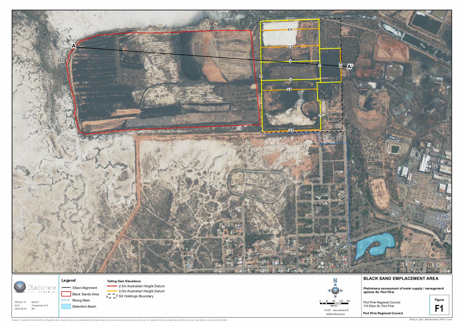
3.2 Description of the BSEA Figure F1 shows the location of the BSEA, the Dead Horse Creek (DHC) Detention Basin and surrounding catchments.
The BSEA is essentially a large rectangular mound (approximately 56 ha in size) of mainly granulated spent slag (the main solid waste product from the smelting process) that has been deposited on flat, clayey samphire.
The BSEA is active with the mound being progressively built up from east to west. There is currently no clear final target landform or rehabilitation plan for the mound. There are future plans to potentially build another mound or to extend the existing mound to another area of samphire to the south.
The BSEA is surrounded to the north, west and south by vacant samphire flats. To the east of the BSEA is the SX Holdings site which has had a range of uses including the processing of ore from the Radium Hill uranium mine. The western SX Holdings tailings dam wall defines the eastern boundary of the area of interest. Further information relating to this site is discussed in Section 3.9.2. Slag deposition has also occurred over the much of the SX Holdings site and the main operational areas of Nyrstar.
The slag is like a fine to coarse unconsolidated sand. Some covering/rehabilitation of the slag pile surface has occurred particularly in the east of the mound.
[Paragraph Removed]
The BSEA straddles a subtle topographic/drainage divide where drainage from the eastern part of the BSEA flows towards the Port Pirie River and drainage from the western part of the BSEA flows to the Spencer Gulf.
3.3 Slag Description The slag in the BSEA largely comprises silicate minerals (containing residual metals) from the smelting process, which have been cooled rapidly to form a glassy material with a sand-like consistency.
As part of the approvals process for allowing deposition of slag on the samphire, extensive leachability testing has been conducted which shows that the slag is relatively benign and has low reactivity. Further testing of the slag leaching potential using town runoff water would need to be conducted as part of further feasibility assessment.
Salt water (sourced from the Port Pirie River) is used in the slag granulation process and some of this salt is entrained with the slag during deposition.
3.4 BSEA Slag Aquifer Description The low samphire area upon which the BSEA sits is a groundwater discharge area. Groundwater levels beneath the area are close to, and in some cases, above ground surface. Groundwater discharge occurs via evaporation from the ground surface and through discharge to rivulets and creeks, which drain towards the Port Pirie River and Spencer Gulf. Covering the samphire with slag removes the potential for groundwater evaporation and to some degree holds up lateral drainage resulting in water saturation at the base of the slag (the formation of a slag aquifer).
Preliminary Assessment of Water Supply/Management Options for Port Pirie 30093 01_Rpt_Final_05sep13
6
Rainfall infiltration at the slag surface adds to water accumulation in the slag. Further, high tides that flood the samphire, result in lateral seepage into the slag mass.
Discharge from the slag aquifer is expected to occur to the BSEA margins, predominantly to the north, west and south. The SX Holdings tailings dam bunds are expected to substantially restrict seepage to the east. Some downward seepage from the slag aquifer is expected to occur when the water level in the slag builds up to a level higher than that of the underlying groundwater.
[Paragraphs Removed]
3.5 Underlying Sediments and Aquifers The underlying sediments and aquifers of the BSEA are important for the following reasons:
• They provide the foundations for any development proposed;
• The permeability of the underlying sediments and water levels within underlying aquifers will, in part, determine the amount of potential leakage from any such storage facility; and
• The sensitivity of the underlying aquifers and associated environments to any promoted leakage, both from an impact on water table level and groundwater quality point of view, would need to be considered.
3.5.1 Foundations
Geotechnical/engineering design and testing would be required as part of further studies.
[Paragraph Removed] 3.5.2 Underlying Stratigraphy and Aquifers
The regional geology and hydrogeology is discussed in more detail in Section 4.2 of this report and should be read first for context. This section focuses on shallow aquifers more likely to be potentially impacted by/or have influence on this development.
The shallow stratigraphy (of relevance to this study) of the BSEA comprises an anthropogenic slag fill layer of variable thickness, underlain by the natural coastal/estuarine sands and clays of the St Kilda Formation comprising samphire clay and a silty/sandy clay aquifer. A sharp contact marks the boundary between the St Kilda formation and the underlying Hindmarsh Clay. The typical stratigraphic section of the BSEA is summarised (from youngest to oldest) below:
• Fill - Granulated Slag;
• St Kilda Formation – Samphire Clay Facies;
• St Kilda Formation – Upper Natural Aquifer Facies (i.e. constituting the upper most natural groundwater system beneath the BSEA); and
• Hindmarsh Clay.
These sediments are shown in cross section on Figure F2.
The St Kilda Formation consists of a variety of sedimentary materials derived from coastal, estuarine and lagoonal environments deposited during the Holocene which directly underlie the granulated slag aquifer within the BSEA. At this locality, the formation can be divided into two distinct sedimentary facies: the Samphire Clay and the Upper Natural Aquifer (UNA).
The Samphire Clay, a brown/blue/grey, soft to stiff, clayey silt and silty clay, is characterised by a lack of coarser alluvium and the presence of shells or shell fragments, seagrass, wood fibres and minor sand, often with a hydrogen sulphide odour In the BSEA, the Samphire Clay has a reported thickness of approximately 2 m. These sediments partially confine the underlying UNA.
The Samphire Clay is underlain by a sequence of grey to brown clayey sand, sandy clay and low plasticity silty clay defined, in this report, as the UNA. The UNA consists of fine to coarse grained sand often containing intact shells, shell fragments and seagrass fibres with hydrogen sulphide odours.
Preliminary Assessment of Water Supply/Management Options for Port Pirie 30093 01_Rpt_Final_05sep13
7
The Hindmarsh Clay located in the BSEA is characterised as a mottled red/brown/grey, stiff to very stiff, medium to high plasticity clay. Aquifers occur in the sandy sediments of the Hindmarsh clay and there is naturally an upward hydraulic gradient from the Hindmarsh Clay aquifer(s) to the UNA.
[Paragraph Removed]
The groundwater quality within the UNA and underlying shallow Hindmarsh Clay aquifers is saline to hypersaline (seawater salinities or higher). Potential contaminants deriving from the slag and/or town runoff water have the potential to impact on the quality of the groundwater in the shallow aquifers underlying and surrounding the BSEA. The principal beneficial use of these shallow aquifers is the maintenance of marine ecosystems in the Spencer Gulf, Port Pirie River and the samphire environment (Government of South Australia, 2003).
Leakage from the slag aquifer could impact potential contaminant migration patterns on the neighbouring SX Holding site. Elevated water levels in the slag aquifer within the BSEA and related elevated water levels in the underlying UNA could promote lateral movement of contamination towards the SX Holdings site. If water levels in the BSEA exceeded the bund height of the tailings dams (approximately 3.0 m AHD as shown on Figure F2) substantial leakage of groundwater (from the perched aquifer system) would likely occur to the tailings dams promoting the potential for further contamination migration. Thus, the state government (specifically PIRSA) would be important stakeholders in any such development.
Any proposed development of the BSEA would have to demonstrate that potential impacts on the underlying and surrounding environment could be effectively managed.
[Paragraph Removed]
3.6 BSEA Water Storage Development 3.6.1 Water Storage Potential
The area of the BSEA has been approximated using Geographical Information System (GIS) methods at 56 Ha. At 20% porosity (conservative estimate) this would equate to the potential to store approximately 112 ML per metre of saturation. Having a target level of say 2.5 m AHD (i.e. 0.5 m below the eastern bund with SX Holdings), this equates to a storage capacity of 112 ML, assuming the base of the slag is at 1.5 mAHD (Figure F2). This is of obvious significance relative to town requirements.
This would still mean that the water table is well below the top of the existing/potential slag surface and not likely to be subjected to significant evaporation.
3.6.2 Bunding
Low permeability and appropriately engineered bunding (or similar) would be required around all the margins of the BSEA for it to be effectively used as a water storage facility. If this was not done, substantial leakage to the slag margins would occur not allowing the build up of the required storage. The engineering design of this bunding, including the assessment of potentially available materials would need to be conducted as part of further studies. It should be noted that Nyrstar has an old clay quarry that may be able to supply some material if this was considered appropriate.
It may be possible to reduce the required bunding length by extending the BSEA to the south, to the existing town levee bank. This would substantially reduce the costs of bund construction, increase potential water storage capacity and provide additional disposal air space for spent slag. An alternative disposal option for Dead Horse Creek Catchment stormwater, in excess of BSEA storage capacity, would need to be sought to replace current overflow basin located to the south of the current BSEA. Further assessment would be required for this.
3.6.3 Water Supply for Harvesting
Any of the town catchments could be used to collect water for potential recharge to the BSEA. The most obvious sources of water are the catchments that report to the Dead Horse Creek (DHC) wetland, which is relatively proximal to the BSEA.
Preliminary Assessment of Water Supply/Management Options for Port Pirie 30093 01_Rpt_Final_05sep13
8
There is already existing infrastructure of a rising main that pumps water from the DHC basin to an outlet drain on the southern boundary of the BSEA. The location of the DHC basin, BSEA, and the existing rising mains are presented on Figure F1.
[Paragraph Removed]
It is well known that dust deposition from Nyrstar has impacted on stormwater quality within the town. This in turn has impacts on the current receiving environment, but also has implications for the quality and usefulness of any harvested stormwater. Collecting water from relatively impacted catchments could be advantageous from an environmental perspective but have limitations on ultimate water quality for use. Capture of this water and promoting greater on-land residence time should create greater opportunity for contaminants to be physically and chemically attenuated.
The three most likely catchments for stormwater harvesting are the DHC catchment (including the city centre), Moppett Road Catchment and Wandearah Road Catchment. This is based on:
• The relatively high load of dust fallout from the Nyrstar smelter, which is further discussed in Section 3.7 below; and
• The utilisation of existing (or partially existing) infrastructure for water transport to the BSEA. The rising main could potentially connect Dead horse Creek Catchment, City Centre Catchment and possibly Wandearah Road Catchment. A second rising main currently pumps stormwater from the Moppett Road Catchment detention basins to the west to an outfall beyond the sea wall. It may be possible to add to this main and direct a branch to the north and then east along the southern boundary of the BSEA.
Of these three catchments, Dead Horse Creek (including the City Centre) could be considered the most favourable for capture due to the relatively high concentrations of lead and zinc reported in dust deposition (Nyrstar, 2012), moderate catchment area and potential yields, proximity to the BSEA and the presence of existing infrastructure. The Wandearah Road catchment could be considered preferable to Moppet Road, based on the higher lead concentrations reported in air samplers within Wandearah Road catchment; however, Moppett Road catchment is larger and reporting higher concentrations of zinc (Nyrstar, 2012).
If the stormwater from the three catchments (Dead Horse Creek, City Centre Catchment, Wandearah Road Catchment) is harvested, a combined yield of approximately 174 ML/year is predicted. A further 150 ML/year is possible if additions to piping infrastructure are possible from the Moppett Road Catchment to the BSEA, resulting in an annual predicted yield of approximately 324 ML.
Assuming that all this water is available for recharge then the BSEA aquifer (set at a 2.5 m AHD water level) could be filled in a period of 3 – 4 months, depending on seasonal factors (assuming no leakage losses or direct rainfall accessions).
It is noted that if targeting relatively impacted stormwater catchments adversely impacted of downstream usability of the water, alternative catchments could be targeted to improve the overall quality of the water harvested.
3.6.4 Recharging the BSEA
Water would need to be largely sediment (and other waste material) free to help prevent clogging of the slag. Some evaluation of this would need to be conducted as part of further assessment.
Water could be pumped into a central BSEA dam(s) and/or trench(es) and simply allowed to infiltrate. Injection bores could also be used. The best configuration could be assessed using numerical groundwater modelling.
A detailed assessment and engineering design of a recharge system would be required as part of subsequent studies.
3.6.5 Extracting the water
This could be done using a series of vertical extraction bores, equipped with pumps and manifolded to a single water main.
Preliminary Assessment of Water Supply/Management Options for Port Pirie 30093 01_Rpt_Final_05sep13
9
It may be more efficient to install a series of horizontal wells (say running north – south) manifolded along the southern boundary which may facilitate gravity drainage to a single main which could be connected to existing pumping infrastructure.
The best configuration could be assessed using the aforementioned numerical groundwater modelling methodologies.
3.7 Water Quality Issues 3.7.1 Stormwater Quality
As noted above, stormwater quality is expected to be impacted, to some degree, by dust deposition from the smelter. Data for the DHC wetland or other stormwater storage water quality is not available for reporting. Some sampling and analysis should be completed as part of further assessment.
A range of organic and inorganic contaminants are commonly expected in stormwater. Despite some potential contribution to the stormwater contaminant load, the issue of bringing a broader range of contaminants back onto the Nyrstar site will need to be resolved.
The DHC Wetland would provide some treatment potential for contaminants (which could possibly be enhanced). The timing and location of water extraction from DHC for recharge could also be manipulated to reduce potential for contamination.
3.7.2 BSEA Aquifer Water Quality
Water quality in the BSEA will vary over time, as water levels build up to supersede the UNA water level and as flushing and leaching occurs. It may take several years of flushing before there is potential (on a salinity basis) to extract directly for irrigation use from the BSEA. This would need to be assessed, perhaps in pilot scale.
Water quality in the BSEA aquifer will also vary pending the quality of the input water (see stormwater quality discussion above). A monitoring program would need to be developed to assess water quality over time.
It is considered likely that the BSEA aquifer may reach capacity and water quality will be unacceptable for intended use and some feedback to the DHC wetland system and ultimate discharge to the Port Pirie River will be required. It is anticipated that this process may result in a net benefit to the surface water system from an environmental perspective (i.e. due to increased residence time increases and associated filtering).
It may be plausible to treat the BSEA aquifer in situ or post storage to improve water quality (see Section 3.7.3 below).
3.7.3 Possible need for treatment post BSEA storage
A number of issues may impact on the ability to use the BSEA stored water. These may include, but not be limited to:
• The suitability of the water for the intended irrigation (i.e. it may be too saline at least initially); and.
• Regulatory requirements mainly relating to the quality of the water and its intended use and potential impacts on human health and the environment.
Treatment options would need to be further assessed and could include, but not limited to:
• Increasing residence times in the BSEA;
• Mixing with mains water or another water source (i.e. groundwater);
• Chemical (i.e. pH adjustment) and physical (i.e. aeration); and
• Filtering (i.e. reverse osmosis).
Given that the town sewer mining is not looking prospective for the Nyrstar ROWT Plant feed, the collection and storage of town runoff water within the BSEA may be an important source of water
Preliminary Assessment of Water Supply/Management Options for Port Pirie 30093 01_Rpt_Final_05sep13
10
for the RO plant. Preliminary discussions with relevant Nyrstar personnel suggest that there is a requirement for an additional 15 ML/annum of water on top of what is available from their Process Effluent Treatment system (PETs) (B.Stanton pers.comm.). The relatively low salinity feed that may be achieved from the BSEA may cost less to treat and in turn provide cost savings to PPRC.
3.8 Regulatory Requirements 3.8.1 Acts, Policy and Guidelines
Injection of stormwater into the BSEA may be legislated under the Code of Practice for Aquifer Storage and Recovery, (SAEPA, 2004). The ASR code complies with the Environment Protection Act 1993 and the Environment Protection (Water Quality) Policy 2003 and is primarily concerned with protection of the environment during ASR schemes. Requirements under the ASR code potentially relevant to the usage of the BSEA as a location of aquifer storage and recovery are outlined below:
• Protection or improvement of the groundwater quality where ASR is practiced, stating that artificial recharge should improve or at least maintain groundwater quality;
• Operators of an ASR project must use a multiple barrier approach (e.g. knowledge of pollutant sources in catchment, detention time, injection shutdown system) to reduce the risk of contamination;
• Water quality of the recovered water should be compliant with the guidelines for the designated environmental value as per the Water Quality Policy (2003); and
• Ongoing monitoring of the aquifer is essential in protecting the groundwater quality and the intended use of the recovered water.
The ASR code may or may not be considered relevant given that the BSEA is not a natural aquifer. However, if the stormwater has higher concentrations of contamination than the groundwater of the current BSEA aquifer system, this could still be problematic. Furthermore, the stormwater may be classified as waste under the South Australian Environmental Protection Act (1993) if it has high concentrations of heavy metals.
Given the high TDS of the groundwater in the region, protected environmental values are likely to be limited to the marine ecosystem guidelines. However, use of the stored groundwater for irrigation in the City of Port Pirie would be subject to the provisions of the Environmental Protection (Water Quality) Policy 2003, South Australia under the Environment Protection Act 1993, which includes maximum pollutant concentrations for irrigation.
3.8.2 Regulatory Approval
The regulatory process for approval of a BSEA water storage facility has not been assessed to date. Overall, the EPA is considered likely to see such a project as a positive one for the environment and community.
However, there are many regulatory steps with this project and strong early support should be sought including some assistance with mapping out the regulatory process.
Key issues will likely be but not limited to:
• Transferring contaminated water from one site to another (i.e. DHC Wetland to the BSEA);
• Potential flushing of the BSEA aquifer back through the DHC wetland (including above issue);
• Impacts on the surface water and groundwater environment on the BSEA aquifer storage;
• Environmental impacts of infrastructure emplacement (pipelines/pumps/roads/bunds etc);
• Irrigation water quality and potential impacts on human health and the environment; and
• Monitoring that would be required.
Preliminary Assessment of Water Supply/Management Options for Port Pirie 30093 01_Rpt_Final_05sep13
11
3.9 Other Third Party Issues 3.9.1 Nyrstar
This project could be seen as a major distraction to core business for the Nyrstar Port Pirie Smelter in a pressured local and global environment. The General Manager has supported in principal the concept of aquifer storage in the BSEA. However, substantial development of the concept and business case will be required.
Any project development team would continue to need strong support from both PPRC and Nyrstar.
Bringing contaminated town run off onto the Nyrstar site (contamination not belonging to Nyrstar) could be a substantial hurdle. Further, the potential to highlight other groundwater issues on its’ site would be a concern.
Strong drivers for Nyrstar support would include:
• The opportunity to help PPRC and the Port Pirie community develop a new water supply and the fact that it will likely help with dust suppression;
• The overall environmental benefit (particularly to the Port Pirie River) specifically in relation to collecting potential Nyrstar derived contamination as well as town contamination;
• The opportunity to leverage the broad ranging benefits – a good news story;
• The possibility of securing a feed water supply to their new ROWT Plant;
• Relatively cheap supply of irrigation water onsite;
• Having a positive use for its slag dumps which may facilitate future approvals for expansion; and
• Sharing costs with PPRC and the possibility of funding through grants.
Note that future expansion of the BSEA to the south could include up front engineering, such as gravity drains and sumps, to enhance water storage and collection potential.
3.9.2 PIRSA
PIRSA is likely to be extremely sensitive to any development that highlights potential issues/creates negative perception at its SX Holdings site.
PIRSA will also have a high level of interest/input in relation to technical studies around how such a development will impact their site. This could be assessed using a numerical groundwater model.
A strategy for engagement of PIRSA would need to be developed carefully.
3.9.3 Community
Although the overall concept could be broadly accepted, there may be issues with perceptions around potentially contaminated water being pumped into park lands around town. In addition, any notion of impacts from SX Holdings may not be received well.
The project will potentially highlight surface water and groundwater contamination issues for the town in general.
A comprehensive community engagement plan would need to be developed.
3.10 Cost A detailed cost benefit analysis (including consideration of alternatives) should be conducted.
Relatively substantial cost items could include:
• Design and approvals process including consulting and permitting;
• Sourcing materials for and creating lateral barriers to BSEA aquifer flow (i.e. bunds);
• Pipe-lines and pumps;
Preliminary Assessment of Water Supply/Management Options for Port Pirie 30093 01_Rpt_Final_05sep13
12
• Water treatment required; and
• Community and other third party consultation.
Some costs could be offset for council through:
• Government grants (existing and new);
• Sharing costs with Nyrstar;
• Undertaking as much work as practicable in-house; and
• Staging the work.
3.11 Summary In summary, use of the BSEA to store town runoff for subsequent use, could be a plausible and important project in helping the PPRC to meet its water supply objectives. There are a number of technical, financial, regulatory, political and community challenges to meet. However, there is potential for a win for all stakeholders and the environment. There appears to be strong merit in pursuing the project further at this stage.
4 Groundwater Supply Potential
4.1 Concept To source a water supply from a local aquifer system via a groundwater bore or bore field for use as an irrigation water supply.
4.2 Regional Geology and Hydrogeology The Port Pirie area lies within a sedimentary basin underlain by Proterozoic-age metasediments of the Adelaide Geosyncline, which form the eastern margin of the basin where they outcrop as the Mt Lofty – Flinders Ranges approximately 15 km west of the Port Pirie township.
The basement geology is comprised of metasediments including feldspathic quartzites and shales, interbedded with dolomitic shales and marble.
A Tertiary and Quaternary age sequence of sediments occurs above basement and is reported to be composed largely of sands, sandy clays and clays (Geological Survey of South Australia, 1964). The overlying Quaternary sequence is reported to contain a basal sequence comprised of sands, gravels and calcrete up to 20 m in thickness, which is overlain by a thick sequence (~80 m) of Hindmarsh Clay (PIRSA, 2004).
The Hindmarsh Clay is overlain in the Port Pirie region by Holocene-aged estuarine/coastal and Aeolian derived clays, silts and sands of the St Kilda Formation, the upper surface of which is composed of samphire clay flats and marshes.
Regional groundwater flow is expected to occur broadly in a westerly direction from regional recharge areas in the southern Mount Lofty – Flinders Ranges and associated colluvial foothills towards the Spencer Gulf. Groundwater flow is expected to occur predominantly within the basal sandy unit of the Quaternary sequence and within the sandy portions of the Tertiary sequence; with the exception of sandy and gravelly lenses, which are likely to be discontinuous. The Hindmarsh Clay is considered to be a regional aquitard. It is expected that the basement rocks would act as a significant regional fractured rock aquifer. The recharge over the basin from rainfall is estimated at 5 mm/yr (Martin et al., 1998).
Discharge of the regional groundwater system is inferred to occur by direct submarine discharge to the Spencer Gulf and by vertical discharge to the coastal flats, including the Port Pirie River and samphire swamplands which characterise the marine margin throughout the region. The geomorphology and ecology of the coastal environment is consistent with it being a regional groundwater discharge zone, consisting of flat, low lying swampland traversed by rivulets, a
Preliminary Assessment of Water Supply/Management Options for Port Pirie 30093 01_Rpt_Final_05sep13
13
watertable lying at or near the ground surface, hypersaline groundwater conditions, salt tolerant vegetation and, in places, salt efflorescence.
Recharge to the deeper Tertiary aquifer (fine grained sands) is reported to occur adjacent to fault lines at the base of the Mount Lofty – Flinders Ranges where the lowest salinity groundwater is typically found (Dooley et al., 2002). This aquifer occurs at depths of up to 100 metres throughout the Pirie Basin and is reported to be under artesian pressure (Martin et al., 1998).
The townships of Nelshaby and Napperby, located approximately 12 km north east of Port Pirie are reportedly underlain by more than 100 m of Tertiary and Quaternary sediments. The deeper Tertiary aquifer supplies good quality water for irrigation but mains water is now being used in preference to groundwater for irrigation (Dooley et al., 2002). It is unclear why mains water is preferred, but presumably it is due to availability and comparable cost.
Aquifers contained in overlying Quaternary sediments are generally unconfined. These aquifers occur in outwash alluvium along old drainage courses (Martin et al., 1998). Groundwater salinity is lowest (800 to 5000 µS/cm) near the foothills of the Mt Lofty - Flinders Ranges and can increase to more than 40,000 mg/L near the Spencer Gulf (Martin et al., 1998).
4.3 Site Selection Prospective areas for an exploitable groundwater resource were identified utilising publicly available map information and borehole databases, primarily on the basis of geological setting, reported groundwater salinity and reported groundwater yield.
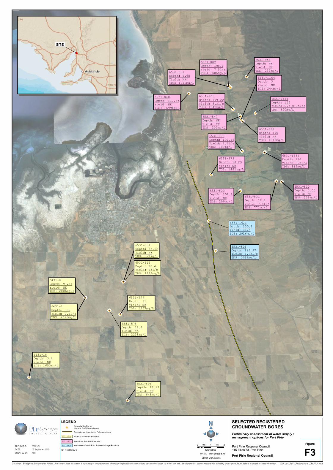
BlueSphere accessed the South Australian Resources Information Geoserver (SARIG) to identify groundwater wells within PPRC boundaries. Features such as palaeodrainage and geological faults were also identified using SARIG. The PIRSA Drillhole Enquiry System (DES) was also accessed and the database information included well construction details, salinity, yield and geological logs. The information accessed from the DES has limitations and should be taken as indicative only as the data presented are single measurement points that have not been verified by repeated measurements. Selected well details are presented in Table 1 – 3 and on Figure F3.
Based on yield and salinity data, two primary areas of interest and a third potential area for groundwater supply were identified as follows:
• The foothills of the Mt Lofty Ranges near Napperby and Nelshby (NortheastNortheast Foothills) ;
• In the vicinity of the Port Pirie airport (South of Port Pirie Township); and
• A palaeodrainage feature running to the south east of Port Pirie (North West – South East Palaeodrainage).
These potential groundwater supply areas are further discussed in the following sections.
4.4 Northeast Foothills A number of existing groundwater wells have been identified to the north east of Port Pirie township, in the foothills of the Mt Lofty Ranges, that exhibit relatively low salinity and/or relatively high yield, indicative of a potential groundwater resource in this area. These bores are shown on Figure F3.
Geologically, the area is underlain by more than 100m of Quaternary and Tertiary unconsolidated sediments abutting basement rocks of the Mt Lofty – Flinders Ranges. The basement rocks in this area are characterised by a relatively high density of fault structures (Martin et al., 1998) with the dominant orientation being approximately north – south, parallel to the edge of the foothills. These structures may allow preferential recharge to the deeper confined aquifer (fine grained Tertiary sands) along the western edge of the Mt Lofty - Flinders Ranges. Quaternary aquifers, referred to collectively as Telford Gravel are reported to be the major aquifers exploited for groundwater supply in the region and are described as coarse-grained alluvial and/or colluvial deposits containing large boulders.
Preliminary Assessment of Water Supply/Management Options for Port Pirie 30093 01_Rpt_Final_05sep13
14
The salinity in the Quaternary aquifers is reported to vary from less than 1,000 mg/L near the foothills of the Flinders and Mt Lofty Ranges to more than 40,000 mg/L near the Spencer Gulf, with salinities in the range of 500 – 3,000 mg/L confined to the immediate area west of the basement hills (Martin et al., 1998), consistent with the data presented on Figure F3. Based on the SARIG well search, groundwater in the Napperby – Nelshaby area typically exhibits relatively low salinity (<1,500 mg/L) and relatively high yield (>2 L/s) across a range of depths, with an increasing salinity trend towards the west. The well locations, depths, yield and salinities are presented on Figure F3 and are summarised below in Table 1.
Table 1 Selected Well Data for the Northeast Foothills Province
Geological Unit
DES Well ID
Year of Data Collection
Depth (m) Yield (L/s) Salinity (mg/L)
SWL (m)
Colluvial Deposits
6531-801 1993 1.65 NK 1012 9.79
6531-830 1949 3.05 NK 528 NK
6531-831 1949 12.8 7.6 771 9.75
6531-973 1949 18.29 NK 1485 NK
6531-1164 1983 3 NK 244 NK
Nelshaby Sandstone / Adelaidean
6531-802 1975 198.1 7.5 1586 3.65
6531-805 1960 179.22 6.3 1642 24.38
6531-808 1949 170.69 2.5 968 30.48
6531-812 1928 175 NK 1213 NK
6531-823 1929 158.8 NK 200 9.14
6531-1534 1998 176 3.3 816 84.81
6531-1535* 1998 154 0.5-0.75 820 72.3
6531-848 1959 117.35 NK 1699 NK
Unknown
6531-958 1974 NK NK 233 NK
6531-847 1949 NK NK 200 NK
Notes: NK – data not known.
SWL (m) refers to Standing Water Level (m below measuring point)
* Source – Martin et al., 1998
Based on the data presented above and previous investigations for a groundwater supply (Martin et al., 1998), there appears to be potential for a borefield to be developed at the foothills of the Flinders Ranges, which could possibly provide an irrigation supply of appropriate quality and volume to met the supply objective. Any such development would require a pipeline and associated infrastructure to reticulate the supply to Port Pirie township.
Preliminary Assessment of Water Supply/Management Options for Port Pirie 30093 01_Rpt_Final_05sep13
15
4.5 South of Port Pirie Township Several wells were identified in the vicinity of the Port Pirie airport that had relatively low TDS (less than 3,000 mg/L) and based on the constructed depths, were likely to be constructed in Quaternary sediments. The well locations, depths, yield and salinity data are presented on Figure F3 and summarised below in Table 2.
Table 2 Selected Well Data for the South of Port Pirie Province
Geological Unit
DES Well ID Year of Data Collection
Depth (m) Yield (L/s) Salinity (mg/L) SWL (m)
Quaternary gravel sand
and clay alluvium
6431-8 1975 97.5 NK 2086 6
6431-18 1975 3.4 NK 1653 1.9
6531-578 1949 78.6 NK 2228 3.1
6531-579 1975 91 NK 1957 5
6531-596 1979 12.2 NK 648 4.6
6531-854 1963 64.6 NK 371 1.8
6531-856 1975 88.4 13 2866 3.6
Basement 6431-7 1949 395 0.6 2628 3.1
Notes: NK – data not known.
SWL (m) refers to Standing Water Level (m below measuring point)
In general, the available data presented above from wells reporting relatively low TDS (<3,000 mg/L) are characterised by a paucity of bore yield information; however, based on the salinity data alone, there appears to be potential for a viable groundwater resource in this area, should sustainable yields be sufficient.
Well 6531-854 was constructed at a depth of 64.6 m below ground surface (bgs) and reported relatively fresh groundwater with a salinity of 371 mg/L. The construction and yield of this bore was not reported. The closest lithological log is from bore 6431-8, located approximately 3 km to the south west, which reported ‘mottled clay, a few thin sand bands’ to a depth of 97.5 m. This area has fluviatile gravels, sand and clay of recent drainage channels (Geological Survey of South Australia, 1983), which are likely to represent alluvial deposits from the meandering Broughton River. Nearby wells reported salinities between 1,950 and 2,886 mg/L TDS, but were constructed approximately 30 m deeper than 6531-854, possibly indicating declining quality with depth in this area.
Several wells were also identified as part of a desktop assessment of the potential for ASR at Port Pirie (AGT, 2007) as having relatively high yields (greater than 2 L/s) from the PIRSA Drillhole Enquiry System (DES), and were thought to be possibly associated with a palaeochannel (AGT, 2007). These wells had salinities between 2,866 mg/L (6531-856) and 6,786 mg/L TDS (not presented in Table 2), and therefore may represent less prospective sequences for a high quality groundwater resource. However, bore 6531-856 (Table 2) has a reported yield of 13 L/s (albeit at a relatively higher salinity), which, if sustainable and/or representative could be considered significant in the context of the water supply objectives for this project.
Preliminary Assessment of Water Supply/Management Options for Port Pirie 30093 01_Rpt_Final_05sep13
16
4.6 Northwest-Southeast Palaeodrainage A number of regional datasets, interpreted from airborne electromagnetic data, including SARIG (2012) and PIRSA (2006), indicate the presence of palaeodrainage features within the Port Pirie Basin.
Palaeodrainage features often host aquifers that typically have a higher storage capacity and hydraulic conductivity than adjacent and more extensive weathered and fractured basement aquifers, and bores can yield relatively higher quantities of water. Cross-sectional areas of palaeodrainage aquifers are often limited by their relatively shallow depth and narrow widths (typically 100’s to 1,000’s of metres), but they can extend for great distances longitudinally down-valley (typically 10’s to 100’s of kilometres). As such, palaeodrainage aquifers often represent valuable groundwater resources.
The available datasets all report a single palaeodrainage feature lying approximately 6 km west of the Port Pirie township with a north – south orientation and extending from the vicinity of the Port Pirie River floodplain to the south for 10’s of kilometres (Figure F3). There is little information available regarding the depth and extent of this feature, water quality or the nature of the stratigraphic sequence. The origin of this feature is also unclear. Based on the former alignments of the Broughton River presented by Rowlett (1997), it does not appear to be a former channel of this or other known major drainage systems in the area.
Two registered groundwater bores have been identified which appear to intersect this feature in the vicinity of Port Pirie. These are shown on Figure F3 and the available data for these wells are summarised in Table 3.
Table 3 Summary of Registered Bores – Northwest-Southeast Paleodrainage
Geological Unit DES Well ID Year of Data Collection
Depth (m)
Yield (L/s)
Salinity (mg/L)
SWL (m)
Lignitic Clays, Sandstone and
Siltstone
6531-1621 1997 130 3 2916 NK
6531-836 1964 125 3.8 3029 NK
Notes: NK – data not known.
SWL (m) refers to Standing Water Level (m below measuring point).
Geological data (driller’s log) from well 6531-1621 indicates lignitic clays, sandy clays, siltstone and sandstone. These descriptions are not necessarily consistent with palaeodrainage strata, which might typically present higher energy deposits such as gravels and sands. Reported salinities are high relative to the other provinces assessed with yields that are comparable or lower than other areas.
On the basis of the available data, it is considered that the identified palaeodrainage feature may represent a lesser prospect for an appropriate groundwater supply when compared to the other options identified. However, it could be targeted for further intrusive investigation, should the other provinces prove unproductive.
4.7 Regulatory Requirements Groundwater resources are managed by the Department of Environment, Water and Natural Resources (DEWNR) and regional NRM boards, under the Natural Resources Management Act (2004).
The provinces identified in this review fall outside all of South Australia’s current Prescribed Water Resources Areas, such that they are not covered by water allocation plans and not subject to the same licensing controls as prescribed areas.
At the very least, any proposal to develop a town water supply from a groundwater well or wells would require a permit to drill and construct a well from the Department for Water. However, an allocation of several hundred ML would likely be subject to review by the relevant NRM board and

Preliminary Assessment of Water Supply/Management Options for Port Pirie 30093 01_Rpt_Final_05sep13
17
government department. Consideration of sustainable yield and potential impacts to surrounding groundwater users would also need to be considered.
Any pipeline and associated infrastructure would also likely to be subject to a regulatory review and approvals process by the relevant authorities.
4.8 Cost As for the BSEA option, a detailed cost benefit analysis would need to be conducted. Relatively substantial cost items could include:
• Exploratory drilling, testing and permitting;
• Pipe-lines and pumps;
• Any water treatment requirements; and
• Community and other third party consultation.
Some costs could be offset for council through:
• Government grants (existing and new);
• Targeting existing pipeline easements, as appropriate;
• Using available information to propose initial exploratory locations;
• Undertaking as much work as practicable in-house; and
• Staging the work.
4.9 Summary In summary, based on the limited available data obtained to date, the concept of obtaining a significant water supply from groundwater (i.e. yields of the order of 50 - 500 ML/annum of adequate quality (i.e. TDS less than 2,000 mg/L)) is considered feasible. The relative prospects of each province identified is briefly summarised below:
• Northeast Foothills: This province is considered the most prospective based on the limited available data and the regional conceptual hydrogeological model. Publically available bore date indicate that the potential yields and quality of groundwater bores in this area are significant in the context of the water supply objective for Port Pirie.
• South of Port Pirie Township: This province is considered less prospective based on salinity data, which is typically higher than the Northeast Foothills. The general paucity of yield data is problematic as it is currently unclear what a representative groundwater yield may be for the alluvial aquifers within this province. However, this could be addressed through further testing.
• Northeast – Southwest Palaeodrainage: This province/feature is considered the least prospective, with the limited available data indicating higher salinities at comparable yields. Palaeodrainage features can form very significant water resources and this particular feature may warrant further investigation should the other provinces prove unproductive or otherwise problematic.
Overall, it is recommended that the PPRC continue to pursue a groundwater supply (in addition to stormwater harvesting and storage in the BSEA). In the event that a stormwater harvesting program proves unfeasible for environmental, regulatory or other reasons, it is considered that a traditional groundwater supply has the potential to provide the required demand, subject to the various considerations noted above.
Preliminary Assessment of Water Supply/Management Options for Port Pirie 30093 01_Rpt_Final_05sep13
18
5 Recommendations Based on the review conducted to date, BlueSphere believes there is merit in pursuing both the stormwater harvesting and storage, and traditional groundwater supply options to a detailed feasibility assessment stage. This will provide a higher level of surety with respect to securing an alternative water supply by the target year 2020.
While the harvesting of stormwater for storage in the BSEA and later reuse for irrigation presents opportunities for positive outcomes on a number of fronts, the approach faces many technical, regulatory and community challenges and is regarded as having only a moderate likelihood of future implementation and success as a result.
By contrast a traditional groundwater supply is likely to have a higher level of initial acceptance, as the concept is well established with regulators and the wider community.
Recommendations specific to each option identified are provided in the following sections.
5.1 Stormwater Harvesting and Storage in the BSEA The following actions are recommended to further advance the investigation of the BSEA as a potential storage facility for town storm water runoff, for later extraction and reuse as irrigation water:
• Continue discussion with Nyrstar management with the view of establishing a project team with joint representation to scope and undertake more detailed assessments including cost benefit analysis. Areas of assessment will likely include but not be limited to:
The likely approval process required;
Future development plans for the BSEA;
Feasibility and applicability of existing or new bund structures to contain storage groundwater in the BSEA;
Investigation of potential clay supplies for possible bunding;
Hydrogeological and geotechnical investigations of the BSEA and surrounds to confirm conditions and provide base data for detailed design;
Design of groundwater recharge and extraction systems;
Recharge and extraction water quality assessment including slag leaching tests;
Assessment of potential environmental impacts;
Numerical modelling of slag BSEA recharge, groundwater extraction and leakage etc.;
Pumping and reticulation planning and design; and
Development of a consultation strategy with third parties.
5.2 Groundwater Supply 5.2.1 Northeast Foothills
The following scope of work is recommended to advance to investigation into the feasibility of establishing a groundwater extraction facility in the Northeast Foothills:
• Undertake a mapping exercise to identify potential drilling targets with reference to available geological and hydrogeological data, land use, including exclusion areas (i.e. National Parks, roads etc.) and existing infrastructure (e.g. the Morgan - Whyalla Pipeline easement);
• Perform aquifer recovery tests and collect groundwater samples, where possible, where existing wells are present within shortlisted areas to confirm the hydrogeological conditions at those locations.
Preliminary Assessment of Water Supply/Management Options for Port Pirie 30093 01_Rpt_Final_05sep13
19
5.2.2 South of Port Pirie Township
The following scope of work is recommended to advance the investigation for a potential water supply South of Port Pirie from the well data identified above.
• Physically locate wells 6531-854 and 6531-856 and confirm their operational state (with permission from the owner/s);
• Gamma log the wells if the casing is accessible to map the lithology, and use a calliper log or down hole camera to help investigate the screen location;
• Perform an aquifer test (pumping or recovery test) to confirm the sustainable yield of the well; and
• Collect groundwater samples for water quality analysis.
5.2.3 Northwest – Southeast Palaeodrainage
No further work is recommended at this stage to further assess the viability of a water supply from the reported palaeodrainage feature. BlueSphere believes there is currently greater merit in pursuing the other options identified.
Preliminary Assessment of Water Supply/Management Options for Port Pirie 30093 01_Rpt_Final_05sep13
20
6 References ANZECC (2000), Australian and New Zealand Guidelines for Fresh and Marine Water Quality. National Water Quality Management Strategy, 2000.
Australian Groundwater Technologies, (2007). Desktop Assessment of the Potential for ASR at Pt Pirie, October 2007.
BlueSphere, 2012. Interim Groundwater Assessment Report, Nyrstar Port Pirie, Site Groundwater Monitoring and Management Plan Implementation, 11 July 2012.
Dooley, T., Henschke, C. and Longbottom, H. (2002). Salinity Management in Province 9, A Groundwater Flow System in the Northern and Yorke Agricultural Districts. March 2002.
EPA South Australia (2004). Code of Practice for Aquifer Storage and Recovery. January 2004.
Geological Survey of South Australia (1964) Burra 1:250,000 Geological Map Sheet I 54-5. Department of Mines Adelaide.
Geological Survey of South Australia (1983) Whyalla 1:250,000 Geological Map Sheet SI 53-8. South Australia Geological Atlas Series.
Government of South Australia (1993). Environmental Protection Act 1993. Version 1.2.2010.
Government of South Australia (2003) Environment Protection (Water Quality) Policy under the Environment Protection Act 1993.
Government of South Australia (2004). Natural Resources Management Act 2004. Version 26.4.2012.
Martin, R., Sereda, A. and Clarke, D. (1998). Spencer Regions Strategic Water Management Study. Primary Industries and Resources SA, DME 37/95. 122pp
Natural Logic, (2011). Port Pirie - Water Supply Augmentation Preliminary Feasibility Study, Project Business Case, August 2011.
PIRSA, 2004. Port Pirie Uranium Treatment Plant. Management Plan – Phase 1 Preliminary Investigation. Report Book 2004/10
PIRSA, 2006. Palaeodrainage and Tertiary Coastal Barrier of South Australia. Digital Geological Map of South Australia 1:2,000,000 Series (1st Edition)
SA Department of Minerals and Energy, (1953). CE 124 Tailings dams design drawings.
SA Department of Minerals and Energy, (1981). Map 4 Port Pirie Tailings Dam Proposed Rehabilitation Plan.
SA Water (2011) SA Water Drinking Water Quality Report 2010-11
Tonkin, (2009). Port Pirie - Stormwater Management Plan, April 2009.
URS, 2006 Port Pirie Rare Earth Treatment Plant - Hydrogeological Investigation, PIRSA PP04-02 Additional Groundwater Characterisation Report
Worley Parsons, (2008). Port Pirie Water Recycling – Feasibility Study, April 2008.
Preliminary Assessment of Water Supply/Management Options for Port Pirie 30093 01_Rpt_Final_05sep13
21
7 Limitations This report was prepared for the sole use of the Port Pirie Regional Council and should not be relied upon by any other person. None of BlueSphere Environmental Pty Ltd or any of its related entities, employees or directors (each a BlueSphere Person) owes a duty of care (whether in contract, tort, statute or otherwise) to any third party with respect to or in connection with this report and no BlueSphere Person accepts any liability for any loss or damage suffered or costs incurred arising out of or in connection with the use this report by any third party.
The report has been prepared with the objectives and scope of work outlined in the proposal dated 3 April 2012. The work was carried out in accordance with the BlueSphere Standard Terms and Conditions.
The conclusions and recommendations provided in this report are based on available information and it is possible that different conclusions and recommendations could be made should new information become available, or with changing site conditions over time. These opinions, conclusions and recommendations are subject to uncertainty given the potentially complex nature of any subsurface environment. Variation in soil and groundwater conditions may vary significantly between the specific sampling and testing locations and other locations at the site.
The report will not be updated if anything occurs after the date of this report and BlueSphere Environmental Pty Ltd will not be obliged to inform any person of any matter arising or coming to its attention after that date.

Preliminary Assessment of Water Supply/Management Options for Port Pirie 30093 01_Rpt_Final_05sep13
22
Figures
A
A'
3
2.5
3
3
2.5
2.5
3
3
2.5
2.5
F1FigurePROJECT ID
DATE30055.2713 September 2012
CREAT ED BY ART
30093_01_FigF1_BlackSandArea_DRAF T_A.mxd
Port Pirie Regional Council115 Ellen St, Port Pirie
BLACK SAND EMPLACEMENT AREAPreliminary assessment of water supply / managementoptions for Port Pirie
Port Pirie Regional Council
0 40 80 120 160Metres
1:6,203 when printed at A3GDA94 MGA Zone 54
Disc laim er: B lu eS phere E nvironm ental P ty Ltd. (Bl ueS phere) does not wa rran t th e accuracy or com pl eten ess of i nfo rm at ion di sp layed in th is m ap and any person us ing it d oes so at thei r own risk . Bl ueS phere shall be ar no respon si bili ty or l iabil it y for an y errors , f ault s , defects or o mi ss i ons i n the inform ati on.
LegendXSect AlignmentBlack Sands AreaRising MainDetention Basin
Tailing Dam Elevations
SX Holdings Boundary
A A' 2.5m Australian Height Datum3.0m Australian Height Datum

? ? ? ? ? ? ? ? ? ? ? ? ? ? ? ? ? ? ? ? ? ? ? ? ? ? ? ? ? ? ? ? ? ? ? ? ? ? ? ? ? ? ? ? ? ? ?
? ? ? ? ? ? ? ? ? ? ? ? ? ? ? ? ? ? ? ? ? ? ? ? ? ? ? ? ? ? ? ? ? ? ? ? ? ? ? ? ? ?
? ? ? ? ? ? ? ? ? ? ? ? ? ? ? ? ? ? ??
? ? ? ? ? ? ? ? ? ? ? ? ? ? ? ? ? ? ? ? ?
? ? ? ? ? ? ? ? ? ? ? ? ? ? ? ? ? ? ? ? ? ? ? ? ? ? ? ? ? ? ? ? ? ? ? ? ? ? ? ? ? ? ?
SX HOLDINGS
WEST
ERN
SITE
BOU
NDAR
YREC DAMDAM x 3
BLAC
K SA
ND E
MPL
ACEM
ENT
BOUN
DARY
-10
-5
0
5
10
15
Eleva
tion m
AHD
WEST EAST
0 100 200 300 400Metres
Disc laimer: BlueSphere Environmental Pty Ltd. (BlueSphere) does not war rant the accuracy or completeness of information displayed in this map and any person using it does so at their own risk. BlueSphere shall bear no responsibili ty or l iabil ity for any errors, faults, defects or omiss ions in the information.
F2Figure
Hor izontal Scale 1:4500
Port Pirie Regional Council115 Ellen St, Port Pirie
CROSS SECTION - NYRSTAR BLACKSANDS EMPLACEMENT & SX HOLDINGSPreliminary assessment of water supply / managementoptions for Port Pirie
Port Pirie Regional Council
30055_19_F7_XSect_BB_Rev_00.mxd
PROJECT IDDATE
30093.0113 September 2012
CREAT ED BY ART
Ground surfaceInterpreted Geological Boundary
? Inferred Geological Boundary
LEGEND
Slag (Slag Aquifer)
Silty / Sandy Clay (Upper Natural Aquifer)
Miscellaneous FillFill
Saint Kilda Formation
Tailings
Samphire Clay
Hindmarsh SandsHindmarsh Clay
SX Holdings Tailings Dam Bunds
@A
@A
@A@A
@A
@A
@A
@A
@A@A
@A
@A
@A
@A
@A
@A
@A
@A@A
@A
@A
@A
@A
@A
@A
6531-1535Depth: 154Yield: 0.5-0.75l/sTDS: 820mg/L
6531-836Depth: 124.97Yield: 3.79l/sTDS: 3029mg/L
6531-1621Depth: 130.3Yield: 3l/sTDS: 2916mg/L
6531-856Depth: 88.4Yield: 13l/sTDS: 2866mg/L
6531-578Depth: 78.6Yield: NKTDS: 2228mg/L
6531-1164Depth: 3Yield: NKTDS: 244mg/L
6531-958Depth: NKYield: NKTDS: 233mg/L
6531-847Depth: NKYield: NKTDS: 200mg/L
6431-18Depth: 3.4Yield: NKTDS: 1653mg/L
6431-7Depth: 395Yield: 0.6l/sTDS: 2628mg/L
6531-579Depth: 91Yield: NKTDS: 1957mg/L
6431-8Depth: 97.54Yield: NKTDS: 2086mg/L
6531-830Depth: 3.05Yield: NKTDS: 528mg/L
6531-812Depth: 175Yield: NKTDS: 1213mg/L
6531-1534Depth: 176Yield: 3.3l/sTDS: 816mg/L
6531-854Depth: 64.62Yield: NKTDS: 371mg/L
6531-831Depth: 12.8Yield: 7.6l/sTDS: 771mg/L
6531-823Depth: 158.8Yield: NKTDS: 200mg/L
6531-801Depth: 1.65Yield: NKTDS: 1012mg/L
6531-596Depth: 12.19Yield: NKTDS: 648mg/L
6531-973Depth: 18.29Yield: NKTDS: 1485mg/L
6531-848Depth: 117.35Yield: NKTDS: 1699mg/L
6531-808Depth: 170.69Yield: 2.5l/sTDS: 968mg/L
6531-802Depth: 198.1Yield: 7.5l/sTDS: 1586mg/L
6531-805Depth: 179.22Yield: 6.3l/sTDS: 1642mg/L
0 0.5 1 1.5 2Kilometres
Disc laimer: BlueSphere Environmental Pty Ltd. (BlueSphere) does not war rant the accuracy or completeness of information displayed in this map and any person using it does so at their own risk. BlueSphere shall bear no responsibili ty or l iabil ity for any errors, faults, defects or omissions in the information.
1:85,000 when printed at A3 F3Figure
GDA94 MGA Zone 55
PROJECT IDDATE
30093.0113 September 2012
CREAT ED BY ART
30093_01_FigF3_RegionalBores_DRAFT_A.mxd
Port Pirie Regional Council115 Ellen St, Port Pirie
SELECTED REGISTEREDGROUNDWATER BORESPreliminary assessment of water supply /management options for Port Pirie
Port Pirie Regional Council
LEGENDGroundwate r Bores(Source: SARI G dat abase )@A
6531-596
6531-831
6531-836
South of Port Pirie Province
North East Foo thills ProvinceNorth West- South East Palaeodrainage Province
NK = Not Known
App roxim ate Location of Palaeodrainage
!(
SITE