Planning & Development Department FINAL PLAT ...
21
301 W. Jefferson St., 1 st Floor, Suite 170 Phoenix AZ 85003 (602) 506-3301 Final Plat Index Internet: www.maricopa.gov/planning 11/19/2021 SUBMITTAL FORMS INDEX Notes: As of December 31, 2012, all Plan of Development applications are subject to ARS §1605. - As of September 13, 2013 all Residential uses are excluded per ARS §11-1605 M.2. The Maricopa County Environmental Services Department (MCESD) – Approval to Construct (ATC) application is also a requirement for Final Plats/Infrastructure Permits. This document can be obtained at MCESD and the ATC is to be submitted directly at MCESD. 1001 N. Central Avenue., Suite 201, Phoenix, AZ 85004 - Telephone: (602) 506-1058. The Maricopa County Environmental Services Stormwater Quality Program – Submittal of Stormwater Pre-Construction Application may be required. Please check the Stormwater Quality website for details on requirements. Applications can be obtained at MCESD and submitted directly at 1001 N. Central Avenue, Suite 300, Phoenix, AZ 85004 – Telephone: (602) 506-5557. http://www.maricopa.gov/2392/Stormwater-Program Final Plat & Infrastructure Permit Application Packet – Any Final Plat application packets printed prior to the listed Effective date identified below are invalid. Please check the Planning and Development website for the most recent version with a listing of application materials and checklists. Planning & Development FINAL PLAT/INFRASTRUCTURE PERMIT PROCESS FINAL PLAT/INFRASTRUCTURE PERMIT CHECKLIST FINAL PLAT APPLICATION FINAL PLAT PROCESS & TIMEFRAME INFRASTRUCTURE PERMIT PROCESS & TIMEFRAME BUILDING ACTIVITY APPLICATION FOR INFRASTRUCTURE PERMIT CONTACT SUPPLEMENTAL FOR INFRASTRUCTURE PERMIT DEADLINE DATES AND BOARD OF SUPERVISORS HEARING DATES Planning & Development Department FINAL PLAT & INFRASTRUCTURE PERMIT This packet can also be used for Re-Plats
Transcript of Planning & Development Department FINAL PLAT ...

301 W. Jefferson St., 1st Floor, Suite 170 Phoenix AZ 85003 (602) 506-3301 Final Plat Index Internet: www.maricopa.gov/planning 11/19/2021
SUBMITTAL FORMS INDEX
Notes:
As of December 31, 2012, all Plan of Development applications are subject to ARS §1605. - As of September 13, 2013 all Residential uses are excluded per ARS §11-1605 M.2.
The Maricopa County Environmental Services Department (MCESD) – Approval to Construct (ATC) application is also a requirement for Final Plats/Infrastructure Permits. This document can be obtained at MCESD and the ATC is to be submitted directly at MCESD. 1001 N. Central Avenue., Suite 201, Phoenix, AZ 85004 - Telephone: (602) 506-1058. The Maricopa County Environmental Services Stormwater Quality Program – Submittal of Stormwater Pre-Construction Application may be required. Please check the Stormwater Quality website for details on requirements. Applications can be obtained at MCESD and submitted directly at 1001 N. Central Avenue, Suite 300, Phoenix, AZ 85004 – Telephone: (602) 506-5557. http://www.maricopa.gov/2392/Stormwater-Program
Final Plat & Infrastructure Permit Application Packet – Any Final Plat application packets printed prior to the listed Effective date identified below are invalid. Please check the Planning and Development website for the most recent version with a listing of application materials and checklists.
Planning & Development
FINAL PLAT/INFRASTRUCTURE PERMIT PROCESS
FINAL PLAT/INFRASTRUCTURE PERMIT CHECKLIST
FINAL PLAT APPLICATION
FINAL PLAT PROCESS & TIMEFRAME
INFRASTRUCTURE PERMIT PROCESS & TIMEFRAME
BUILDING ACTIVITY APPLICATION FOR INFRASTRUCTURE PERMIT
CONTACT SUPPLEMENTAL FOR INFRASTRUCTURE PERMIT
DEADLINE DATES AND BOARD OF SUPERVISORS HEARING DATES
Planning & Development Department
FINAL PLAT & INFRASTRUCTURE PERMIT This packet can also be used for Re-Plats

301 W. Jefferson St., 1st Floor, Suite 170 Phoenix AZ 85003 (602) 506-3301 Final Plat Infrastructure Permit Process Internet: www.maricopa.gov/planning 11/19/21
A SUBDIVISION, is defined by ARS §32-2101. Any subdivision within the unincorporated area of Maricopa County must be approved by the Board of Supervisors prior to being recorded. An application for a Final Plat and Infrastructure Permit must be filed with the Planning and Development Department. Please note that applications must be complete. Intake may reject incomplete applications and/or applications that are submitted after 4:00 p.m. Both a pre-application meeting discussing the submittal requirements and a pre-submittal meeting documenting the required submittal documents are required.
ARS § 1605 PROCESS
After the Preliminary Plat is approved, the owner or authorized agent may submit the Final Plat and related Infrastructure Plans to the Planning and Development Department. The Final Plat must meet the requirements set forth by the Planning and Zoning Commission, the Maricopa County Subdivision Regulations, and be in substantial compliance with the approved Preliminary Plat. The Final Plat and Infrastructure Permit will be reviewed by Maricopa County Departments of Transportation, Environmental Services, Stormwater Quality, Library, Parks and Recreation, Flood Control District, Drainage Review, Addressing, Building Plan Review, Comprehensive Planning, and Current Planning. The Final Plat may also be routed electronically to applicable fire department, any town or city within three miles of the site of the plat, and other interested parties. These reviewing agencies may require additional information in order to review the Final Plat. As of September 13, 2013, both the Final Plat and Infrastructure Permit process shall be subject ARS § 1605, a State statute that mandates establishment of timeframes to either approve or deny a “license” as defined by the statute. The full statute may be viewed at:
http://www.azleg.gov/arstitle/ The statute sets up two types of review timeframes: Administrative and Substantive. The Board of Supervisors (BOS) through the P-30 Licensing Timeframes Ordinance has adopted a 90 (working) day administrative timeframe and a 180 (working) day substantive timeframe for Final Plats and Infrastructure Permits (Subdivision). These are separate applications with separate timeframes. An application related to a residential use is not subject to the statute.
An application that is part of a design build project may establish a negotiated timeframe process during the pre-application meeting. Administrative Review Period The statutes allow for multiple reviews during the administrative review period. Substantive Review Period Only one review is allowed for the substantive review period. The County can amend the substantive review comments to address legal requirements not identified on the original substantive review comments. After receipt of the concurrent submittal of both the Final Plat and the Infrastructure Permit, the statutory review process differs. Whereas the Infrastructure Permit is deemed administratively complete at acceptance of submittal, after receipt of a Final Plat application, the administrative review period begins and Planning will review for administrative completeness. The applicant will receive a formal response from their assigned planner and may be required to submit additional information. Once Final Plat administrative comments have been given to the applicant, the timeframe clock will stop and will resume upon resubmittal of the Final Plat application materials. Once the application is deemed administratively complete, the planner will formally notify the applicant and One Stop Shop (OSS) agencies that the Final Plat has entered the substantive review period. At this time the Final Plat substantive review will commence and the Final Plat substantive timeframe clock stops from receipt of comments until the applicant makes a formal resubmittal. **Note: The Infrastructure Permit is on a separate review and substantive timeframe clock. A Infrastructure Permit combined review will be provided to the applicant separately from the Final Plat review comments at which point the Infrastructure Permit Substantive timeframe clock will stop. At any time during the process, an applicant can check the status of their applications by viewing the Online Permit Manager on the Planning and Developments website:
https://accela.maricopa.gov/citizenaccessmcoss/ The applicant’s assigned planner can also be utilized as a resource for checking the status of the applications. If at any time comments are given to the applicant, a notation will be made as to the administrative or substantive timeframe frame remaining which will not resume until a resubmittal is made.
Planning & Development Department
FINAL PLAT/INFRASTRUCTURE PERMIT PROCESS

301 W. Jefferson St., 1st Floor, Suite 170 Phoenix AZ 85003 (602) 506-3301 Final Plat Infrastructure Permit Process Internet: www.maricopa.gov/planning 11/19/21
**Note: It is very important to return the planner’s comment memo upon resubmittal so that the appropriate statutory timeframe can resume. Depending on the comments received, the application materials may need revisions. The applicant must submit revised materials for both the Final Plat and Infrastructure Permit, reflecting the comments, to the OSS, which will forward the revised materials to the appropriate agencies. The applicant’s resubmittal must meet the County’s technical requirement or it will be denied.
BOARD OF SUPERVISORS (BOS)
When the reviewing County agencies have deemed that substantive review is complete for both the Final Plat and related Infrastructure Permit and surety has been posted, the Final Plat will be scheduled for a Board of Supervisors hearing date and the statutory clock will stop. The applicant will be directed by the assigned Planner to obtain property owner signatures
on one (1) set of mylars. These mylars will then be submitted to the Planner who will obtain signatures from Planning and Development, Assessor’s and Treasurer’s offices. Please note, a later BOS date may be necessary if signatures are delayed or not obtained.
POST-BOS ACTIVITY
After the BOS approves and signs the Final Plat, the assigned planner will pick up the mylars from the Clerk of the Board (typically takes 1 week after Board hearing). The applicant will be contacted to pick up the mylars for recordation. The applicant will then resubmit two (2) full-size folded paper copies of the recorded final plat and an Adobe PDF version to the planner with completed plan revision sheet as an “Addendum” including project name and tracking number. Failure to submit the Addendum as required, shall delay the approval of the Infrastructure Permit. OSS Quality Control will notify the contact person upon approval of the related Infrastructure Permit and the payment of fees will authorize the permit to be issued.

301 W. Jefferson St., 1st Floor, Suite 170 Phoenix AZ 85003 (602) 506-3301 Final Plat Checklist Internet: www.maricopa.gov/planning 11/19/2021
Applications submitted to the Maricopa County Planning & Development Department shall include all of the exhibits and information listed in this checklist. Applications will not be accepted for processing until the following information has been provided. Application(s) determined to be incomplete shall not be processed by staff. An intake meeting must be scheduled with the assigned Planner that processed the Preliminary Plat for submittal of the Final Plat and Infrastructure permit, intake of application materials must be submitted prior to 4:00 p.m.
REQUIRED MEETINGS PRIOR TO FINAL PLAT AND INFRASTRUCTURE PERMIT(S) SUBMITTAL 1. PRE-APPLICATION MEETING ____ One (1) copy of the pre-application meeting form. 2. PRE-SUBMITTAL MEETING ___ Contact the assigned Planner to schedule a Pre-Submittal meeting with Planning and
Development Services representatives. The meeting is to review the Final Plat and Infrastructure checklists and to address any questions or comments. Date: __________________________ Time:______________________________
3. INTAKE MEETING – SUBMITTAL OF FINAL PLAT AND INFRASTRUCTURE PERMIT(S) ____ Contact the assigned Planner to schedule an Intake Meeting for Final Plat and Infrastructure
Permit submittal. The meeting will allow County staff to review application materials and to coordinate the intake of application/permits with assignment of a Final Plat case number and Infrastructure Permit numbers. Intake Meeting must be scheduled before 4:00 p.m. Date: __________________________ Time:______________________________
FINAL PLAT CHECKLIST 4. APPLICATION: ____ Copy of the Pre-application meeting form – 1 copy ____ Final Plat application forms - Nine (9) copies ____ Letter addressed to Board of Supervisors with the following information: (1 copy) Request for approval, name and address of subdivider, party responsible for preparing the
plat and verification of Final Plat submittal to cities or towns within three (3) miles of plat. ____ Copy of Certificate of 100 – Year Assured Water Supply from Arizona Department of Water
resources (1 copy – optional with initial application submittal, required prior to scheduling for Board of Supervisors).
____ Recorded deed (unofficial copy is acceptable)- 1 copy ____ Electronic copy of application materials – 2 CDs or 2 Flash Drives
Final Plat application (PDF copy with signatures) save as APPL-FORM-1 Narrative Report- PDF copy save as NARR-RPTS-1 Final Plat – PDF copy save as PLAT-PLAN-1 Excel files of the lot, tract and site summary tables - Excel files Building activity application – PDF copy save as BLDG-APPL Contact supplement – PDF copy save as CONT-DETL Infrastructure Plans – PDF copy Sealed Surveyor’s Boundary Closure Report – PDF copy save as SURV-RPTS
Planning & Development Department
FINAL PLAT/INFRASTRUCTURE PERMIT APPLICATION CHECKLIST

301 W. Jefferson St., 1st Floor, Suite 170 Phoenix AZ 85003 (602) 506-3301 Final Plat Checklist Internet: www.maricopa.gov/planning 11/19/2021
Planning & Development Department
FINAL PLAT/INFRASTRUCTURE PLAN APPLICATION CHECKLIST
5. FINAL PLAT INFORMATION: Please see Maricopa County Subdivision Regulations for additional
requirements. Provide Nine (9) collated, folded, and stapled copies of large-scale plans (not to exceed 24” x 36” in size), and 1 copy of an 8 ½” x 11” reduction of each page.
____ Date of plat and subsequent revision dates ____ Vicinity map with location of plat ____ Include Index sheet with small scale map. ____ Name, address, phone and fax numbers of the property owner, developer/sub divider,
Engineer/Surveyor, etc. ____ Identification of Plat by name, location by section, township, range and county, legal
description, zoning district, and case number ____ Provide plat specific plan legend. The legend shall include all linework, hatching,
abbreviation and symbols used. Do not include items not shown on plat. ____ Excepted parcels accurately described by bearings and distances ____ Add the following under a NOTES section on the coversheet of the Final Plat ____ This site consists of a total of ___ lots, ____ tracts, and ____ parcels in the ______ zoning
district. ____ Final Plat is in substantial conformance with the Preliminary Plat case number_______
If the Plat is not in substantial conformance with the Preliminary Plat, state the reasons for modification/changes with the Final Plat.
____ There shall be no further division of land or parcels within the area of this Subdivision Plat without approval by the Board of Supervisors.
____ This subdivision was issued a Certificate of Assured Water Supply by the Arizona Department of Water Resources on _______, ADWR Certificate Number ________________. This subdivision will be served by the ____________ Water Company.
____ Fire protection for this subdivision will be served by ______. A ‘will serve’ letter dated ______ has been received from __________.
____ Development and use of this site will conform to all applicable Maricopa County Codes and Ordinances.
____ All new and relocated utilities shall be placed underground. ____ All roads, private or public shall be designed and constructed to minimum County
standards. The appropriate roadway dedication(s) shall be contained on the plat.
Where all streets are public include the following dedication on the plat: All streets identified on this plat are hereby dedicated to Maricopa County so that upon recordation of this plat, the fee of the streets reserved to the use of the public vests in trust to Maricopa County for the uses and to the extent depicted on the plat. Approval of a plat shall not be deemed to constitute or effect an acceptance by the County for designation of any street into the County maintenance system. However, at the time the streets are fully completed in accordance with the approved plat and written specifications made by the Maricopa County Board of Supervisors, the County shall accept the streets into the County maintenance system within one year of completion.
Where internal streets are private but perimeter streets are public include the following dedication on the plat): The streets identified on this plat as _______________________________ [insert names of appropriate (perimeter) streets] are hereby dedicated to Maricopa County so that upon recordation of this plat, the fee of said streets reserved to the use of the public vests in trust to Maricopa County for the uses and to the extent depicted on the plat.

301 W. Jefferson St., 1st Floor, Suite 170 Phoenix AZ 85003 (602) 506-3301 Final Plat Checklist Internet: www.maricopa.gov/planning 11/19/2021
Planning & Development Department
FINAL PLAT/INFRASTRUCTURE PLAN APPLICATION CHECKLIST
Approval of a plat shall not be deemed to constitute or effect an acceptance by the County for designation of any street into the County maintenance system. However, at the time said streets are fully completed in accordance with the approved plat and written specifications made by the Maricopa County Board of Supervisors, the County shall accept the streets into the County maintenance system within one year of completion. The streets identified on this plat as ______________________________[insert names of appropriate (private/internal) streets] within Tract(s) ____ are and shall remain private streets and all obligations related to said streets, including but not limited to maintenance, shall rest with the fee title holder of said streets.
Where all streets are private streets include the following dedication on the plat: The streets identified on this plat as ______________________________ [insert names of appropriate private streets] within Tract(s) ___are and shall remain private streets and all obligations related to said streets, including but not limited to maintenance, shall rest with the fee title holder of said streets.
Where some or all of the perimeter streets are within other jurisdictions include the following dedication on the plat: The street(s) identified on this plat as _______________________ [insert name(s) of appropriate street(s)] is (are) hereby dedicated to <INSERT NAME OF CITY OR TOWN> so that upon recordation of this plat, the fee of the streets vests in trust to <INSERT NAME OF CITY OR TOWN> for the uses and to the extent depicted on the plat.
____ No structure of any kind shall be constructed or any vegetation to be planted or be allowed to grow within any drainage easements which would impede the flow of water over, under or through the easement.
____ All new landscape improvements installed by this subdivision within County Right-of-Way shall comply with MCDOT Roadway Design Manual and be maintained by the ________ Homeowners Association.
____ The __________________ Homeowners Association shall be responsible for the maintenance and upkeep of all landscaping and drainage facilities within tracts and easement as dedicated on said plat.
____ All outdoor lighting will conform to the provisions of Section 1112 of the Maricopa County Zoning Ordinance.
____ Ingress/egress access and maintenance rights shall be granted to Maricopa County for all tracts dedicated on said plat for the purpose of inspection and maintenance of public drainage facilities adjacent to or within said tracts.
____ Boundary of parcel(s) to be subdivided fully balanced and closed. Provide signed and sealed surveyor’s Boundary Closure Report.
____ Corners noted and monuments found or set indicated; excluded tracts indicated ____ Location and description of cardinal points to which all dimensions, angles, bearings, and
similar data shall be referenced. Each of two corners shall be tied to separate section or quarter section corners
____ North arrow and scale (written and graphic). Scale no more than 100 feet to inch ____ If applicable – Identification of UPD characteristics, including a table comparing the base
zoning district standards to the proposed UPD standards (see example in Zone Change packet).

301 W. Jefferson St., 1st Floor, Suite 170 Phoenix AZ 85003 (602) 506-3301 Final Plat Checklist Internet: www.maricopa.gov/planning 11/19/2021
Planning & Development Department
FINAL PLAT/INFRASTRUCTURE PLAN APPLICATION CHECKLIST
____ Tables containing each lot, tract/parcel by number, width, area and use (tracts only). If on separate sheet, must be sealed and signed by preparer of plat; identify all changes made from preliminary plat by footnote. See sample tables below, provide Excel files of tables as part of the electronic copies.
Lot Tract Table Lot # Sq. Ft. Acres Width Zoning
District 1 2 * TOTAL - -
* Lots that changed in width, size, number from the approved Preliminary Plat Case Number: _______.
Tracts/Parcel Table Tract Sq.
Ft. Acres Use
Tract A Tract B Parcel 1 TOTAL -
Site Summary Table
Square Feet Acreage Gross Acreage Total Lots Acreage Total Tracts Acreage Total Parcels Acreage Total Right-of-way Acreage Net (Gross Minus Right-of-way)
____ Street names and right-of-way dimensions. Name, centerline, right-of-way lines, course,
lengths and widths of all public and private streets, alleys, crosswalks and utility easements; radii, points of tangency and central angles of all curvilinear streets and alleys and radii of rounded street intersections.
____ 25’ x 25’ sight-visibility triangles (SVTs) at all street corners ____ Typical lot layout for interior and street-side lots with the zoning district standards for lot width,
front, rear, side and street side setbacks. ____ Identification of all lots reserved for schools or fire stations ____ Identification of all drainage easements and tracts (Note: Drainage Tracts are preferable
over easements). ____ Indicate FEMA FIRM information and floodplain designation. Show boundaries for all
floodplain and/or floodway limits. ____ Name, book, and page number of adjacent recorded subdivisions, with location of existing
adjacent lots, easements, and rights-of-way. Provide note “unsubdivided” where appropriate.
____ If applicable – Identification of a condominium and its characteristics ____ If applicable – Identification of all “hillside areas” per MCZO ____ The following Surveyor’s Certification Statement shall be included on the Final Plat cover
sheet: ____ i. I, _________________________, hereby certify that I am registered professional land
surveyor in the State of Arizona; that this plat hereon has been prepared from a survey performed by me or under my direct supervision; that the survey is true and accurately represents the property described heron. I further certify that all monuments exist or will be set as shown, that all lot corners are set or will be set, in accordance with the latest adapted “Arizona Boundary Survey Minimum

301 W. Jefferson St., 1st Floor, Suite 170 Phoenix AZ 85003 (602) 506-3301 Final Plat Checklist Internet: www.maricopa.gov/planning 11/19/2021
Planning & Development Department
FINAL PLAT/INFRASTRUCTURE PLAN APPLICATION CHECKLIST
Standards”; and that said monuments are sufficient to enable the survey to be retraced. _________________________________________ (provide Surveyor name Arizona registration number, contact information)
____ Space for Certifications (signatures) from the following Maricopa County agencies:
____ i. ASSURANCE STATEMENT – PLANNING AND DEVELOPMENT Assurance, for provision of required subdivision improvements and infrastructure, sufficient to protect Maricopa County and in accordance with the requirements of A.R.S. § 11-821 and A.R.S. § 11-822 and the Zoning Ordinance for the Unincorporated Area of Maricopa County has been provided in a form acceptable to the Director of the Maricopa County Planning and Development Department. ___________________________________ ____________ Planning & Development Date
____ ii. CERTIFICATION OF COUNTY ASSESSOR I, the undersigned, as a Deputy County Assessor, Maricopa County, Arizona, do herby certify that as of this date, the records of this office reflect that ______ and _______ as designated on the plat as owners of the properties as shown on the plat and more particularly described as assessor parcel number(s) ______________________. ___________________________________ ____________ Deputy County Assessor Date
____ iii. CERTIFICATION OF COUNTY TREASURER I, the undersigned, as a Deputy County Treasurer, Maricopa County, Arizona, do herby certify that as of this date the records of this office reflect that there are no tax liens on any of the parcels comprising the plat, as listed in the Assessor’s Certification with the following exceptions: ______________________. ___________________________________ ____________ Deputy County Treasurer Date
____ iv. Space for approval by the Board of Supervisors under the signature of the Chairman of the Board, and attested to by the Clerk of the Board BOARD OF SUPERVISORS Approved by the Board of Supervisors of Maricopa County, Arizona on this _____ day of _____ 20__. ___________________________________ Attested by: __________________ Chairman of the Board Clerk of the Board

301 W. Jefferson St., 1st Floor, Suite 170 Phoenix AZ 85003 (602) 506-3301 Final Plat Checklist Internet: www.maricopa.gov/planning 11/19/2021
Planning & Development Department
FINAL PLAT/INFRASTRUCTURE PLAN APPLICATION CHECKLIST
____ v.
Blank space (up to 2” x 4”) on each plat sheet for Maricopa County Recorder’s Office to place Recordation information sticker.
6. NARRATIVE REPORT: (Brief explanation of the project. Nine (9) copies – 8½” x 11” paper. Underlined
wording indicates a section heading.) ____ A. Title Page – include project name, general location, case/tracking # and vicinity map ____ B. Purpose of Request ____ C. Description of Proposal ____ D. Relationship to Surrounding Properties ____ E. Location and Accessibility ____ F. Circulation System (on & off-site) – include proposed improvements or dedications ____ G. Development Schedule (phasing) ____ H. Community Facilities and Services (school district, parks, amenities, etc.) ____ I. Public Utilities and Services (refuse, sewer, water, police, fire, etc.) ____ J. Attach copy of the Notice of Intent of (NOI) for Stormwater Discharges
7. Soils Report – Two (2) copies (if required). Check with Engineering - to determine if a Soils Report is required.
8. Traffic Impact Study/Analysis – Two (2) copies (if required). Check with Engineering – MCDOT to determine if required.
9. DRAINAGE REPORT (2 copies with CDs) – Drainage Report to include CD with PDF file of the report with all exhibits, and digital executable file of all hydrology and hydraulic models used (i.e. HEC-1, FlowMaster, Excel files, etc.).
10. INFRASTRUCTURE PERMIT (7 completed, collated, and rolled plan sets and 7 transmittal letters):
Plan sheets must be numbered consecutively and be accompanied with a transmittal letter which includes the name of the Final Plat with Subdivision case number and Infrastructure Permit number(s) with each item by description and quantity. Subsequent submittals, the number of revised infrastructure plans may be reduced, the Combined Review Comments will specify the number of copies for resubmittal. Infrastructure permit plans shall be completed, collated and rolled in the following order:
____
Coversheet with Index
____ Grading and Drainage (including Subdivision Perimeter Walls and Retaining Walls) ____ Wet and Dry Utilities ____ Paving and Storm Drain ____ Signage and Striping ____ Streetlight Plans (if applicable) ____ Landscape Plans (plantings and ground covers, all right-of-way and common areas,
irrigation water meters and landscape electrical meters). Infrastructure Permits plan review approvals are valid for one (1) year upon issuance, building permit expires 180 days from date issued or the last approved/passed inspection.
Note: it is the responsibility of the owner or authorized agent to submit complete sets of plans and
all required documents. Any errors or omissions will result in rejection or a request for complete plans that meet submittal requirements. Intake may accept the submittal based on the transmittal letter.
____
Building Activity Application and Contact Supplemental - Seven (7) copies.

301 W. Jefferson St., 1st Floor, Suite 170 Phoenix AZ 85003 (602) 506-3301 Final Plat Checklist Internet: www.maricopa.gov/planning 11/19/2021
Planning & Development Department
FINAL PLAT/INFRASTRUCTURE PLAN APPLICATION CHECKLIST
11. FINAL PLAT AND INFRASTRUCTURE PERMIT FEES Final Plat Application Fees (due at initial application submittal): ____ A. Planning Review Fee:
Final Plat $40 per lot, tract, or parcel ($1000 min., $10,000 max.) Change to an application for a license in progress - $50 For an application to be added to an application for a license in progress - $50 To re-initiate application for a license administratively denied due to time (within 180 days) - $50 Appeal of administrative denial of a license due to time (within 30 days) - $150 No application shall be scheduled for hearing by the Board of Supervisors unless and until all fees and fines owed to the Department as a result of any activity or inactivity attributable to the property that is the subject of the application are brought current and paid in full or any amounts owed pursuant to an agreement of compliance are current, as the case may be. This requirement shall not be waived by the Board of Supervisors. See Maricopa County Subdivision Regulations (MCSR), Chapter 4 – (www.maricopa.gov/planning)
____ B. Addressing Review Fee - $10 per lot.
____ C. Maricopa County Department of Transportation (MCDOT) Review Fee - $100.
____ D.
Maricopa County Environmental Services Department (MCESD) Review Fee of $225.
____ E. Drainage Review Fee: $1,000 + $25 per acre Maximum of $10,000
____ F. Recording fees are due after Final Plat recordation. Infrastructure Permit Upfront Review Fees (fees due at initial permit submittal): Building Plan Review Fee - $300
Drainage Review Fee - $2,000 + $250 per acre (Maximum of $42,300) MCDOT Review Fee - $100 per sheet Zoning Review Fee - $250 Address Verification - $10 A portion of remaining fees will be due with resubmittal of infrastructure permits; the remaining fees will be due at time of infrastructure permit issuance, whichever occurs first.
How to Calculate Projected Total Infrastructure Permit Costs 1. Building Plan Review fees – based upon cut & fill – See Local Additional & Addenda – Section
208 Fees – Grading and Plan Review Fees: Maricopa County Local Additions & Addenda Landscape water meters $100 each ($50 Address assignment, $50 permit fee)
2. Landscape electrical meters $100 each ($50 Address assignment, $50 permit fee) 3. Retaining walls exceeding four feet in height, as measured from the bottom of footing to top
of wall: building plan review and building permit fees based on height and linear footage as listed in the Local Additions & Addenda, Section 208.

301 W. Jefferson St., 1st Floor, Suite 170 Phoenix AZ 85003 (602) 506-3301 Final Plat Checklist Internet: www.maricopa.gov/planning 11/19/2021
Planning & Development Department
FINAL PLAT/INFRASTRUCTURE PLAN APPLICATION CHECKLIST
4. Ramadas and shade structures exceeding 200 sq. ft. or with plumbing, mechanical or electrical: building plan review and building permit fees based upon square footage and type of construction as listed in the Local Additions & Addenda, Section 208.
5. Signs: building plan review and building permit fees based on valuation as listed in the Local Additions & Addenda, Section 208.
6. Walls to be used as pool barriers: building plan review and building permit fees based on wall material type and linear footage as listed in the Local Additions & Addenda, Section 208.
7. Pool barrier requirements are outlined in the Local Additions & Addenda, Section 210 and summarized in Maricopa County Department Directive DD-2012-15.
Other Related Fees: MCDOT Right-of-Way & Floodplain Use Permit or Floodplain Delineation Review – will be assessed directly from MCDOT and Flood Control District upon application submittal. MCDOT Right-of-way Permit fee is based upon 3% of the approved Engineer’s Cost Estimate and will be collected at time of right-of-way permit issuance. Subdivision Surety Bond Requirements: A subdivision surety will be required to be posted prior to approval of Final Plat and subdivision infrastructure permits.
1. Surety amount will be based on approved engineer’s cost estimate for the subdivision infrastructure improvements. Cost Estimate will be requested by County Engineering reviewers as part of the infrastructure plan review process, typically after plans are in substantial conformance and ready for approval.
2. Engineer’s cost estimate shall be signed and sealed by an Arizona registered Civil Engineer. 3. Surety may be provided in the form of cash/check or performance bond. 4. If a performance bond will be used, a fully executed copy of the bond must be submitted for
review and approval first, prior to posting of the bond. All performance bond forms will be reviewed and approved by Maricopa County Attorney’s Office (MCAO). A copy of the County standard performance bond form is available for download on MCDOT website:
http://www.mcdot.maricopa.gov/DocumentCenter/View/357
Any modification to the standard County form or submittal of alternate forms will require additional review time.
12. APPROVAL TO CONSTRUCT (ATC) – MARICOPA COUNTY ENVIRONMENTAL SERVICES (MCESD) The following documents are to be submitted directly to Maricopa County Environmental Services – Subdivision Infrastructure and Planning Program:
Cover/Transmittal Page for MCESD Projects ATC Fees Approval to Construction application (1 copy) Full size set of plans with each page sealed and signed by Engineer (1 set) Water Design Report – Water project only (must be sealed and signed by registered Engineer) Sewer Design Report – Sewer projects only (must be sealed and signed by registered Engineer) Sewer Capacity Letter – must be issued by the sewer utility provider, NOT the Engineer
ATC packet can be downloaded at the following web address:
www.maricopa.gov/environmental services/subdivisions/forms/applications Submit ATC directly to MCESD Permit Dropbox at Planning and Development Department :
301 W. Jefferson St., Suite 170 Phoenix, Arizona 85003 Telephone: 602-506-6160

301 W. Jefferson St., 1st Floor, Suite 170 Phoenix AZ 85003 (602) 506-3301 Final Plat Checklist Internet: www.maricopa.gov/planning 11/19/2021
Planning & Development Department
FINAL PLAT/INFRASTRUCTURE PLAN APPLICATION CHECKLIST
13. AMENITY CONSTRUCTION PERMITS: Amenity construction plans are to be submitted after construction of the subdivision infrastructure. Follow the Commercial Building Permit application packet for submittal documents. Amenity Construction Permits include ramadas, subdivision signage, common area lighting, and structures in common areas. These do not include plantings and related landscaping within right-of-way. 14. REPLAT SUBMITTAL DOCUMENTS: See checklist above for specific detail information:
Nine (9) Final Plat application form One (1) Letter to the Board of Supervisors One (1) copy of Certificate of 100- Year Assured Water Supply form the ADWR One (1) Unofficial or official recorded deed One (1) CD of electronic copy of application materials Nine (9) copies of the replat on 24” x 36” One (1) replat reduction on 8 ½” x 11” Two (2) Drainage Reports & 1 CD/DVD/Flash Drive of report - if required (check with Planning
Engineering) 15. REPLAT FEE SCHEDULE
____ A. Planning Review Fee: Final Plat $40 per lot, tract, or parcel ($1000 min., $10,000 max.) Change to an application for a license in progress - $50 For an application to be added to an application for a license in progress - $50 To re-initiate application for a license administratively denied due to time (within 180 days) - $50 Appeal of administrative denial of a license due to time (within 30 days) - $150 No application shall be scheduled for hearing by the Board of Supervisors or administratively approved unless and until all fees and fines owed to the Department as a result of any activity or inactivity attributable to the property that is the subject of the application are brought current and paid in full or any amounts owed pursuant to an agreement of compliance are current, as the case may be. This requirement shall not be waived by the Board of Supervisors. See Maricopa County Subdivision Regulations (MCSR), Chapter 4 – (www.maricopa.gov/planning)
____ B. Addressing Review Fee - $10 per lot. ____ C. Maricopa County Department of Transportation (MCDOT) Review Fee - $100. ____ D. Maricopa County Environmental Services Department (MCESD) Review Fee of $225. ____ E. Drainage Review Fee:
$1,000 + $25 per acre Maximum of $10,000 Re-Plat for Note Corrections or Easement Adjustments without Drainage Input -
$60.00 Other Corrections: $1,000 + $25 per acre – Maximum of $10,000
____ F. NOTE: Recording fees are due after Replat recordation.

301 W. Jefferson St., 1st Floor, Suite 170 Phoenix AZ 85003 (602) 506-3301 Final Plat Checklist Internet: www.maricopa.gov/planning 11/19/2021
Planning & Development Department
FINAL PLAT/INFRASTRUCTURE PLAN APPLICATION CHECKLIST
Map Recordation Criteria checklist can be obtained from the Maricopa County Recorder’s Office:
http://recorder.maricopa.gov/site/maprecordation.aspx Map Recordation Criteria for Subdivisions:
24” x 36” on Polyester or Linen (Mylar) per ARS §11-481B – original map Title Section with type of plat, name of subdivision, description by section, township & range, name
of owner of record. Seal and Signature – All seals and signatures must be originals and in black ink to ensure
reproduction. Legibility – all maps must be legible to reproduce legibility. Drawn to accurate scale with at least 11 point type with left margin of 2 inches. Approvals by governing body of County with original signatures per ARS § 9-475; ARS §9-478
16. MARICOPA COUNTY AGENCY CONTACTS: Planning and Development: (602) 506-3301 Planning Engineering
(Drainage, Flood Control and Transportation - MCDOT)
(602) 506-3301
Addressing: (602) 506-3301 Environmental Services (MCESD): (602) 506-1058 Stormwater Quality Program: (602) 506-5557 Assessor: Recorder: Treasurer:
(602) 506-3406 (602) 506-3535 (602) 506-8511

301 W. Jefferson St., 1st Floor, Suite 170 Phoenix AZ 85003 (602) 506-3301 Final Plat Application Internet: www.maricopa.gov/planning 11/19/2021
Is this Design Build? Yes No Is this Residential? Yes No
Please select the type of application from the checkboxes: Final Plat with Infrastructure Re-Plat REQUEST
Final or Re-Plat: Title of Project: Description of Request: Number of Lots, Tracts, and/ or Parcels: Gross Density per Dwelling Unit: Existing Zoning District: Related Case Number/s:
PROPERTY INFORMATION Address (if known): General location (include nearest city/town):
Net acres: Township: Range:
Gross acres: Legal Description Section: Assessor’s Parcel Number/s: Subdivision Name (if applicable):
OWNER’S AUTHORIZED AGENT INFORMATION Name: Contact: Address: City: State: Zip: Phone #: Fax#: E-mail Address:
PROPERTY OWNER INFORMATION Name: Contact: Address: City: State: Zip: Phone #: Fax#: E-mail Address:
PROPERTY OWNER AND OWNER’S AGENT AUTHORIZATION
I (property owner) authorize (owner’s agent) to file this application on all matters relating to this request with Maricopa County. By signing this form as the property owner I hereby agree to abide by any and all conditions that may be assigned by the Maricopa County Board of Supervisors, Maricopa County Planning and Zoning Commission, or Maricopa County Planning and Development Department staff as applicable, as part of any approval of this request, including conditions, development agreements, and/or any other requirement that may encumber or otherwise affect the use of my property.
INSPECTIONS By submitting this application, I am inviting County staff to conduct all site inspections they deem necessary. PROPOSITION 207 WAIVER
The property owner acknowledges that the approval being sought by this application may cause a reduction in the existing rights to use, divide, sell or possess the private property that is the subject of this application. The property owner further acknowledges that it is the property owner who has requested the action sought by the filing of this application. Therefore, with full knowledge of all rights granted to the property owner pursuant to A.R.S.§12-1132 through 1138, the property owner does hereby waive any and all claims for diminution in value of the property with regard to any action taken by Maricopa County as result of the filing of this application.
Property Owner Signature: Date:
VERIFICATION OF APPLICATION INFORMATION I certify that the statements in this application and support material are true. Any approvals or permits granted by Maricopa County in reliance upon the truthfulness of these statements may be revoked or rescinded. Owner or Authorized Agent Signature: Date:
ARS § 1605 TIMEFRAME EXTENSION I authorize a 50% timeframe extension for the review of my application as adopted by the Board of Supervisors per ARS § 1605 and as amended.
Property Owner Signature: Date:
Planning & Development Department
FINAL PLAT APPLICATION ALL FEES ARE DUE AT TIME OF APPLICATION AND ARE NON-REFUNDABLE

301 W. Jefferson St., 1st Floor, Suite 170 Phoenix AZ 85003 (602) 506-3301 Final Plat Process Internet: www.maricopa.gov/planning 11/19/2021
* Approximate Final Plat timeframe of 5 months. ** Concurrent review of related infrastructure permit may delay in Final Plat timeframe. *** See Final Plat Checklist for Surety Bond Requirements.
Planning & Development Department
FINAL PLAT PROCESS AND TIMEFRAME
Submittal of application at front counter or via EDR **
Technical Advisory Committee (TAC) meeting (approximately 4 – 6 weeks based upon availability)
Board of Supervisors hearing (approximately 4 weeks following sign-off)
Assigned to planner & routed to reviewing agencies and stakeholders (approximately within 1 week of application) Review comments will be provided prior to TAC Meeting.
Sign-off (approximately 2 weeks)
Post TAC resubmittal (within 2 weeks)
Review comments (approximately 2 weeks
following resubmittal)
Application resubmittal (at applicant’s discretion)
* 60 days
Final Plat Approval by the Board of Supervisors Recordation of the Mylars
(approximately 1 week after Board hearing)
Applicant to deliver 2 copies of recorded Mylars to Planning and Development, pay outstanding infrastructure permit fee
with infrastructure permit issuance.
*** Surety to be posted with delivery of Mylars Applicant to obtain owner and notary
signatures
Planner will obtain Planning, Assessor and Treasurer signatures on Mylars prior to scheduling for Board
Infrastructure Permit submittal (see Infrastructure
Permit Process)
Approval to Construct submittal to MCESD
Approval to Construct must be Issued before Final Plat
approval
Infrastructure Permit must be in a ready to be issued
Status before scheduling Final Plat for the Board of
Supervisors

301 W. Jefferson St., 1st Floor, Suite 170 Phoenix AZ 85003 (602) 506-3301 Final Plat Process Internet: www.maricopa.gov/planning 11/19/2021
Planning & Development Department
INFRASTRUCTURE PERMIT PROCESS & TIMEFRAME
Submittal of Infrastructure Permit at front counter or via EDR
Combined Review Comments will be sent via e-mail to applicant from all County agencies
(approximately 2 – 4 weeks based upon availability)
Routed to reviewing agencies (MCESD, Zoning, Engineering) (approximately within 1 week of permit submittal)
Technical Sign-off received, Infrastructure Permit in Ready to be Issued Status, pending
Final Plat approval by the Board and recordation of the
mylars.
Post resubmittal (at applicant’s discretion)
Standard Plans – Allowance of unlimited permits on a construction plan with a limited number of options can be used. Standard Plans once approved and issued are valid
for three years.
Standard Plans can be utilized with Single Family Residential, pools, spas, and accessory buildings.
See Substantive Policy Statements for submittal
requirements and additional information.
https://www.maricopa.gov/1911/Department-Directives
Model Home Complex – see Substantive Policy Statements for submittal requirements to construct a
Model Home Complex in a recorded Subdivision
http://www.maricopa.gov/1911/Department-Directives
Model Home Complexes 2018-06
Infrastructure Permit Plan Approval – valid for a 1 year timeframe.

Planning & Development Department BUILDING ACTIVITY APPLICATION PACKET
DEVELOPMENT DISCLAIMER NOTICE By initialing / signing this application and disclaimer, I state that I am either the owner of record of the parcel and/or authorized by the owner(s) to represent them regarding the subject parcel. I understand that the issuance of a Building Permit for this property (APN _______________) by Maricopa County DOES NOT GUARANTEE THE AVAILABILITY OF POTABLE WATER AT THIS SITE. I also am aware and understand that issuance of the Building Permit does not obligate Maricopa County to issue a permit for electrical service for a shared well to serve this site, should this site be included within a private shared well agreement. FEE INFORMATION • For residential projects, there is an online fee estimator to assist with planning / preparing for your project
- Fee Schedule and Estimators • An upfront fee will be required upon acceptance. • If the application / permit submittal is not approved on the initial review, full permit fees will be required at
the time the revised submittal is accepted. • Any remaining fee balance must be paid prior to permit issuance. • If a permit application is denied, any unearned fees will be refunded. LICENSING TIMEFRAMES - A.R.S. 11-1605 As of September 13, 2013, residential, subdivision and commercial design-build permitting projects have been exempted from the above referenced statute. Commercial and industrial permitting projects continue to have two review phases – Administrative (performed at the point of intake) and Substantive involving technical review of the submittal plans and documents. Depending on the permit type, there may be multiple areas and departments reviewing the plan submittal, i.e., Zoning Plan Review, Building Plan Review, Drainage Plan Review, Environmental Services, the Flood Control District, and/or the Department of Transportation. Once all areas have reviewed, any comments will be sent by email in a Combined Review format listing each area and the results or findings. The combined review cycle must be complete prior to any resubmittal. Any review comments or requests for supplemental information will reference the applicable ordinance, regulation or code supporting the comment / request. PRE-APPLICATION MEETINGS • Commercial projects will require a Pre-Application meeting at a cost of $350.00
o (Excluding wireless cell tower facilities, tenant improvements and those projects that participated in the Pre-Application process during the entitlement or Planning phase).
• Residential projects with an open Code Enforcement Violation case may be required to have a Pre-Application meeting prior to accepting the application / submittal packet at a cost of $150.
• Residential projects may choose to participate or schedule a Pre-Application meeting at a cost of $50.
Initials: ____________

Planning & Development Department BUILDING ACTIVITY APPLICATION PACKET
(Continued – Page 2)
304 4/25/2017
PERSONAL ASSURANCE OF SUBMITTAL ACCURACY I, ______________________________, hereby unconditionally and without reservation guarantee and warranty to Maricopa County that the documents submitted to Maricopa County Planning and Development, including but not limited to the application materials and/or any and all site plan(s) and building plans, provide a true and accurate depiction of the requested construction and accurately reflect the existing conditions of the subject parcel. I also certify, to the best of my knowledge, that each of the buildings, structures, and conditions reflected on the submitted plan is in compliance with the Maricopa County Zoning Ordinance, which may be found at Zoning Ordinance (P-18) I am aware that Maricopa County Planning and Development will rely upon the accuracy of the materials provided to perform a Zoning Clearance review, as required in the Maricopa County Zoning Ordinance, Section 1504.5. I have also seen and verified that the submitted site plan materials include and accurately provide all listed items on the Department’s Site Plan Checklist. I am aware and understand that the issuance of a Building Permit does not represent that Maricopa County has verified or authenticated the veracity of any materials submitted in support of the application for permit. I understand that Maricopa County will issue a Building Permit based upon the subject materials and that any falsification of documentation submitted as part of this permit application may void the Building Permit upon which it is based. In addition, issuance of a Zoning Clearance in conjunction with this application by the Department does not approve or imply the approval of other structures, permitted or unpermitted, which may be on the same property, but which are not the subject of this permit request. PERSONAL GUARANTEE OF FINANCIAL RESPONSIBILITY I, __________________________, (print name) hereby absolutely, unconditionally and irrevocably guarantee to Maricopa County the prompt payment of any and all fees and charges in connection with this application, without the necessity of Maricopa County first seeking payment from the named applicant. This includes that if at any time, a written cancellation is submitted for this project application, I personally guarantee prompt payment of the balance of any and all fees and charges incurred. Initials:
____________
Initials: ____________


301 W. Jefferson St, Suite 170 Phoenix AZ 85003 (602) 506-3301 (602) 506-8510 fax 3043
Internet: www.maricopa.gov/planning 09/13/2013
EMAIL ADDRESS IS REQUIRED FOR ALL APPLICATIONS
CONTRACTOR INFORMATION / LICENSED CONTRACTOR VERIFICATION
Provide your information below and if licensed, verify that you are a licensed contractor under ARS Title 32, Chapter 10, Article 2.
LICENSE NUMBER AND CLASS:
NUMBER CLASS
TRUST ACCOUNT NUMBER:
TYPE OF LICENSE: Check one:
Architect Contractor Developer Engineer
COMPANY NAME:
STREET ADDRESS:
CITY/STATE/ZIP:
MAILING ADDRESS: (If different from above)
CITY/STATE/ZIP:
CONTACT 1: CONTACT 2:
TITLE: TITLE:
PHONE NUMBER: ( ) PHONE NUMBER: ( )
ALTERNATE NUMBER: ( ) ALTERNATE NUMBER: ( )
BUSINESS FAX: ( ) BUSINESS FAX: ( )
E-MAIL: E-MAIL:
OWNER / AGENT / CONTACT INFORMATION
OWNER NAME: BUSINESS NAME:
ADDRESS: ADDRESS:
CONTACT 1:
PHONE NUMBER: ( )
PHONE NUMBER: ( ) CONTACT 2:
ALTERNATE: ( ) PHONE NUMBER: ( )
FAX NUMBER: ( ) FAX NUMBER: ( )
E-MAIL: E-MAIL:
Planning & Development Department
CONTACT SUPPLEMENTAL
PLANNING & DEVELOPMENT DEPARTMENT
301 W. Jefferson St., 1st Floor, Suite 170 ▪ Phoenix AZ 85003 ▪ (602) 506-3301 www.maricopa.gov/planning
Final Plat & Infrastructure Permit 11/19/2021
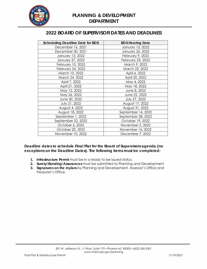
2022 BOARD OF SUPERVISOR DATES AND DEADLINES
Scheduling Deadline Date for BOS BOS Hearing Date December 16, 2021 January 12, 2022 December 30, 2021 January 26, 2022
January 13, 2022 February 9, 2022 January 27, 2022 February 23, 2022 February 10, 2022 March 9, 2022 February 24, 2022 March 23, 2022 March 10, 2022 April 6, 2022 March 24, 2022 April 20, 2022
April 7, 2022 May 4, 2022 April 21, 2022 May 18, 2022 May 12, 2022 June 8, 2022 May 26, 2022 June 22, 2022 June 30, 2022 July 27, 2022 July 21, 2022 August 17, 2022
August 4, 2022 August 31, 2022 August 18, 2022 September 14, 2022
September 1, 2022 September 28, 2022 September 22, 2022 October 19, 2022
October 6, 2022 November 2, 2022 October 20, 2022 November 16, 2022
November 10, 2022 December 7, 2022
Deadline dates to schedule Final Plat for the Board of Supervisors agenda (no exceptions on the Deadline Dates). The following items must be completed:
1. Infrastructure Permit must be in a ready to be issued status. 2. Surety/Bonding/Assurances must be submitted to Planning and Development 3. Signatures on the mylars by Planning and Development, Assessor’s Office and
Treasurer’s Office.