Potential of remote sensing of cirrus optical thickness by ...

Optical Remote Sensing
GIMA: Geographical Information Management and Applications

False colour photograph (NIR – 1.0 µm)

Thermal infrared image (TIR – 10 µm)

Remote Sensing (Earth Observation)
Earth
Sensor at a distance
EM energy

Scanning systems
Opto-mechanical scanner (whiskbroom scanner): - image construction point by point - 1 line at a time - photon detectors
Linear array scanner (pushbroom scanner): - image construction line by line - CCD detectors
Progression sensor platform
2-dimensional image construction

Principles imaging sensor systems
Pushbroom scanner Whiskbroom scanner
digital recording analogue recording digital recording
scanning mirror shutter
“point” detector
aerial image plane line array detector
imaging optics imaging optics
Camera (aerial photography)
imaging optics

Remote sensing instrumentation
General concept
Terrain objects
Sens
or
Recorder Detector
angular aperture
IFOV
Instanteneous field of view - ground resolution element
β
IFOV= β*H (in Nadir!)
H
Collector
Ground receiving station
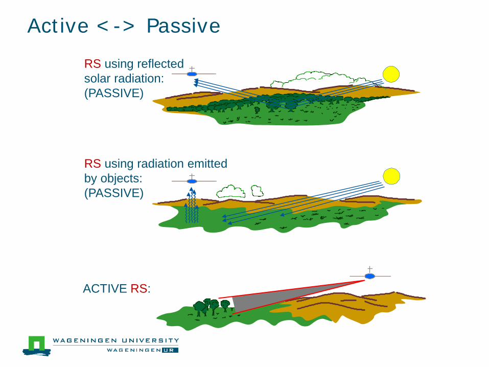
Active <-> Passive
RS using radiation emitted by objects: (PASSIVE)
RS using reflected solar radiation: (PASSIVE)
ACTIVE RS:

Lelystad Airport: Dornier (Foreground) Piper (Back)

Dornier (inside) with camera mount (foreground) and MSS-scanner (middle)

Multispectral scanner

Resolution concepts
Spectral resolution ● Band width in nm or Hz ● Mid-value ● Sensitivity curve
Spectral range
● Number and position of bands
λ 0
½
1
“50% - width”
sensitivity
0.3 µm 70 cm

IKONOS Multispectral bands

Resolution -2-
Spatial resolution ● Size IFOV or ● Pixel size in terms of terrain size
D = β·H at nadir ≥ β·H at oblique viewing angles
H
β
sens
or
radiometer
D ground resolution element (resolution cell)
β = angular aperture (mrad)

Example of resolution simulation

Resolution -3-
Radiometric resolution ● Smallest measurable step ∆Q ● Noise level Qmin
● Saturation level Qmax
● Dynamic range =10·log(Qmax/ Qmin) in dB
S
Q B Qmax
A Qmin
∆Q
Smax B’
Smin A’
∆S

AD conversion
• 6 bits: 64 digitization levels • 8 bits: 256 digitization levels • 10 bits: 1024 digitization levels • 12 bits: 4096 digitization levels
NOISE may be caused by: • sensor/imaging system • atmosphere • variability terrain object
76543210 Number 79: 01001111 How many bit levels are significant?

The position of the spectral bands of some Remote Sensing sensor systems in the optical window
wavelength (µm)
red middle-
infrared near- infrared bl
ue
gree
n
dry soil
water wet soil vegetation re
flect
ance
(%)
SPOT HRG Panchromatic
Pan: IKONOS, Quickbird, GeoEye, WorldView
Meteosat NOAA AVHRR
Landsat TM
40
20
0 0.8
60
0.4 1.2 1.6 2.0 2.4
SPOT HRG multispectral
Multispectral: IKONOS, Quickbird, GeoEye, WorldView

Some sensor specifications
Altitude (km) FOV (km) Radiometric resolution
(bits)
Spatial resolution (m)
nadir
Meteosat 36,000 hemisphere 8 2500/5000
NOAA-AVHRR 835 3,000 10 1100
Landsat-TM 705 185 8 30/120
SPOT (P/XS)
822 120 8 10/20
SPOT-Vegetation 822 2250 8 1165
IKONOS (P/MS)
681 11 11 1/4
QuickBird (P/MS) 450 14 11 0.6/2.4