Metropolitan and Micropolitan Statistical Areas in ... · Library of Michigan / LDDS Department of...
16
Library of Michigan / LDDS Department of History, Arts, and Libraries Revised June 25, 2003 Page 1 Metropolitan and Micropolitan Statistical Areas in Michigan Based on the 2000 Census Overview. Each decade, the U.S. Office of Management and Budget makes new designations of metropolitan areas based on the latest census. New designations were released in OMB Bulletin 03-04, dated June 6, 2003. In addition to reflecting updated information, the new lists reflect major changes to definitions and criteria. Four counties—Barry, Cass, Ionia, and Newaygo—are classified as metropolitan for the first time. Three other counties which have been metropolitan until now—Allegan, Lenawee, and Midland—have been shifted to a new “micropolitan” category. Twenty other Michigan counties are also classified as micropolitan. Twenty-two metropolitan and micropolitan counties are part of newly established “combined statistical areas.” In addition, the term “central city” has been replaced by the term “principal city.” Twenty- nine Michigan communities have been designated as principal cities of metropolitan areas, including thirteen communities that had not been central cities in the past. Only one Michigan central city—Port Huron—has not been designated as a principal city. Midland, which had previously been one of the central cities of a metropolitan area, is among the sixteen Michigan cities that have been designated as principal cities of micropolitan areas. Tables 1 through 3 list Michigan’s metropolitan areas, micropolitan areas, and combined statistical areas. The attached maps show the counties that have been classified as metropolitan under the standards implemented in 1993 as well as the counties that are classified as metropolitan or micropolitan under the new standards. Tables 4 and 5 list the Michigan communities that were designated as central cities in 1993 or as principal cities in 2003. Table 6 shows the population of each designated statistical area. At the time of the 2000 Census, 92 percent of Michigan’s population resided in the 49 counties that are now designated as metropolitan or micropolitan: Number of Counties Percent of State Census Count Metropolitan Areas 26 81% Micropolitan Areas 23 11% Other Counties 34 8% Additional Resources. The following additional resources are available: The new designations were officially released in OMB Bulletin 03-04: http://www.whitehouse.gov/omb/bulletins/b03-04.html http://www.whitehouse.gov/omb/bulletins/b03-04_attach.pdf
Transcript of Metropolitan and Micropolitan Statistical Areas in ... · Library of Michigan / LDDS Department of...
Library of Michigan / LDDSDepartment of History, Arts, and LibrariesRevised June 25, 2003 Page 1
Metropolitan and Micropolitan Statistical Areasin Michigan Based on the 2000 Census
Overview. Each decade, the U.S. Office of Management and Budget makes newdesignations of metropolitan areas based on the latest census. New designations werereleased in OMB Bulletin 03-04, dated June 6, 2003.
In addition to reflecting updated information, the new lists reflect major changes todefinitions and criteria. Four counties—Barry, Cass, Ionia, and Newaygo—are classified asmetropolitan for the first time. Three other counties which have been metropolitan untilnow—Allegan, Lenawee, and Midland—have been shifted to a new “micropolitan” category.Twenty other Michigan counties are also classified as micropolitan. Twenty-twometropolitan and micropolitan counties are part of newly established “combined statisticalareas.”
In addition, the term “central city” has been replaced by the term “principal city.” Twenty-nine Michigan communities have been designated as principal cities of metropolitan areas,including thirteen communities that had not been central cities in the past. Only oneMichigan central city—Port Huron—has not been designated as a principal city. Midland,which had previously been one of the central cities of a metropolitan area, is among thesixteen Michigan cities that have been designated as principal cities of micropolitan areas.
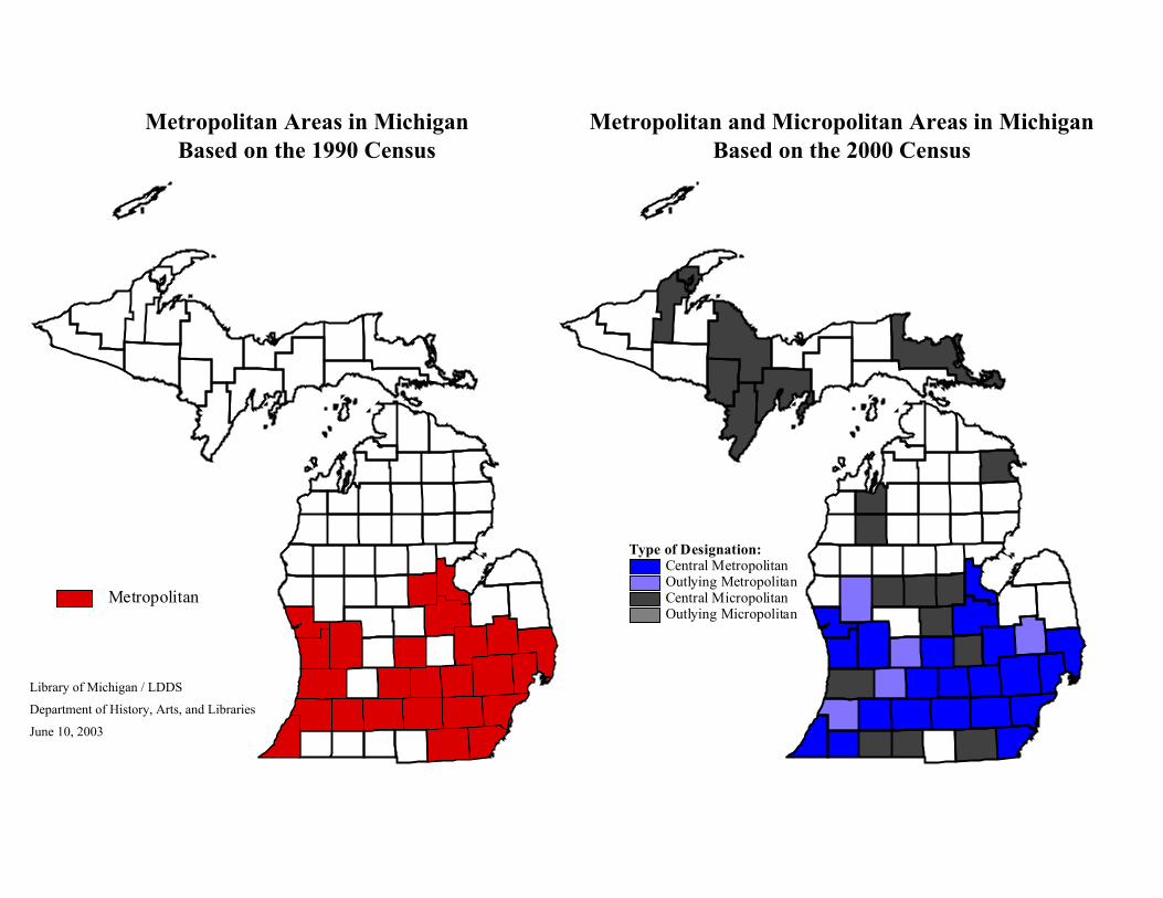
Tables 1 through 3 list Michigan’s metropolitan areas, micropolitan areas, and combinedstatistical areas. The attached maps show the counties that have been classified asmetropolitan under the standards implemented in 1993 as well as the counties that areclassified as metropolitan or micropolitan under the new standards. Tables 4 and 5 list theMichigan communities that were designated as central cities in 1993 or as principal cities in2003. Table 6 shows the population of each designated statistical area.
At the time of the 2000 Census, 92 percent of Michigan’s population resided in the 49counties that are now designated as metropolitan or micropolitan:
Number of Counties Percent of State Census Count Metropolitan Areas 26 81% Micropolitan Areas 23 11% Other Counties 34 8%
Additional Resources. The following additional resources are available:
The new designations were officially released in OMB Bulletin 03-04:http://www.whitehouse.gov/omb/bulletins/b03-04.htmlhttp://www.whitehouse.gov/omb/bulletins/b03-04_attach.pdf

Library of Michigan / LDDSDepartment of History, Arts, and LibrariesRevised June 25, 2003 Page 2
The newly implemented standards for metropolitan and micropolitan statistical areas werepublished in the Federal Register for December 27, 2002, pp. 82228-82237:
http://www.census.gov/population/www/estimates/00-32997.pdf
The previous standards for metropolitan areas were published in the Federal Register forMarch 30, 1990, pp. 12154-12160.
Implications of the New Designations. The new designations can potentially affect anyfederal, state, or non-governmental programs that use metropolitan categories for funddistribution, program qualification, or other purposes. Some uses are required by legislationor regulations, while others are subject to agency discretion.
Uses of metropolitan categories at the federal level have included:� Compilation of statistics by the Census Bureau, Bureau of Labor Statistics, Department
of Agriculture, Bureau of Economic Analysis, Department of Energy, National Center forHealth Statistics, and other agencies.
� Definition of the wage indices, cost levels, and cost limits used in computing Medicareand Medicaid payments.
� Computation of employment benchmarks for use in monitoring equal employmentopportunity.
� Calculation of school and library “E-Rate” discounts for telecommunication servicesunder the Telecommunication Act of 1996.
� Targeting of loans by the Farmers Home Administration.� Targeting and financing of programs by the Health Resources and Services
Administration.� Targeting of Community Development Block Grants.� Calculation of rent subsidy levels by the Department of Housing and Urban
Development.� Determination of prevailing wage rates for federal contracts.� Monitoring of compliance with fair housing and fair lending laws.� Definition of local banking markets and community reinvestment areas.� Definition of areas covered by geographically-targeted air pollution control
requirements.1
Examples of state laws that are potentially affected by changes in the Census Bureau’smetropolitan categories include:� Metropolitan Transportation Authorities Act (Act 204 of 1967).2
1 Most examples cited at the federal level are from “Uses of Metropolitan Areas by Federal Agencies,” attachment toOffice of Management and Budget Memorandum M-94-22, May 5, 1994.2 See MCL 124.402, Sec. (2)(g). This act is referenced in several other state laws, such as the Motor Carrier FuelTax Act (Act 119 of 1980), the General Property Tax Act (Act 206 of 1893), the State Highway Trunkline SystemAct (Act 51 of 1951), the Limousine Transportation Act (Act 271 of 1990), the Motorbus Transportation Act (Act432 of 1982); and the Motor Carrier Safety Act (Act 181 of 1963).
Library of Michigan / LDDSDepartment of History, Arts, and LibrariesRevised June 25, 2003 Page 3
� Metropolitan Councils Act (Act 292 of 1989).3
� Article VII, section 27 of the Michigan Constitution.� Obsolete Property Rehabilitation Act (Act 146 of 2000).4
� General Sales Tax Act (Act 67 of 1933).5
� Single Business Tax (Act 228 of 1975).6
� Acquiring Property for Highway Purposes (Act 352 of 1925).7
� Acquisition of Property for Public Highways (Act 295 of 1966).8
� Public Health Code (Act 368 of 1978).9
� Mortgage Lending Practices Act (Act 135 of 1977).10
It should be noted that legislative bodies can make exceptions to the federal classificationswith respect to specific laws. For example, although Lapeer county has been classified asmetropolitan since 1963, it is not considered part of a metropolitan statistical area forpurposes of the Metropolitan Transportation Authorities Act of 1967.11 Any federal, state, orother agency that uses the designations for non-statistical purposes can also modify them forthose particular purposes, unless constrained by contrary legislation.12
Terminology. The new standards retain some previous terminology and introduce newterminology:- “Urbanized Areas” are densely settled areas with 50,000 or more persons that can cut
across city and township boundaries. Although the standards for defining urbanizedareas change somewhat each decade, the term has been in use for many years. Newurbanized areas were designated in 2002 based on the 2000 Census.
- “Urban Clusters” are densely settled areas with fewer than 50,000 persons that can cutacross city and township boundaries. This term was introduced with the 2000 Census,and urban clusters were first designated in 2002.
- The term “Urban Area” encompasses both urbanized areas and urban clusters.- “Metropolitan Statistical Areas” consist of one or more counties that contain an urbanized
area or have a high level of commuting to or from counties that contain an urbanizedarea. Although the standards for defining metropolitan areas change somewhat eachdecade, this term has been in use since the 1980’s. (A similar term—Standard
3 See MCL 124.653, Sec. (3)(d).4 See MCL 125.2782, Sec. 2 (i)(D).5 See MCL 205.54l, Sec. 2(b).6 See MCL 208.37b, Sec. (5)(b).7 See MCL 213.171, Sec. 1(f).8 See MCL 213.361, Sec. 1(f).9 See MCL 333.21566, Sec. (2)(a), which designates essential access community hospitals; 333.21567 Sec. (2)(a),which designates rural primary care hospitals; and 333.22207 Sec. (7), which specifically amends the provisions forrural primary care hospitals to reflect application of the new federal standards for metropolitan and micropolitanareas.10 See MCL 445.1601, Sec. 1 (h); 445.1602, Sec. 2(1); 445.1608, Sec. 8(3); 445.1675a, Sec. 25a (1)(e).11 See MCL 124.402, Sec. 2(g).12 See U.S. Office of Management and Budget, OMB Bulletin 03-04, June 6, 2003, section 4.

Library of Michigan / LDDSDepartment of History, Arts, and LibrariesRevised June 25, 2003 Page 4
Metropolitan Statistical Area—was used from the time metropolitan standards were firstestablished in 1950 until 1983.) The new standards for designating metropolitan countiesare described in detail below.
- “Micropolitan Statistical Areas” consist of one or more counties that contain a sizeableurban cluster or have a high level of commuting to or from a county containing an urbancluster. This term was introduced with the new standards being implemented in 2003.Standards for designating micropolitan counties are described in detail below.
- The term “Core Based Statistical Area” (CBSA) encompasses both MetropolitanStatistical Areas and Micropolitan Statistical Areas. This term was introduced with thenew standards being implemented in 2003.
- “Combined Statistical Areas” (CSA’s) are groupings of metropolitan and/or micropolitanareas that are linked economically, as measured by substantial levels of commuting. Forvery large metropolitan areas, this term is comparable to the term “ConsolidatedMetropolitan Statistical Area” that was used in the standards that were implemented in1993. However, because the CSA standards recognize economic linkages that are nolonger recognized in the metropolitan standards themselves, other CSA’s are actuallycomparable to previously defined MSA’s.
- “Metropolitan Divisions” are subdivisions of very large metropolitan areas. The Detroit-Warren-Livonia metropolitan area is the only area in Michigan that is divided intometropolitan divisions.
- “Principal Cities” are cities, villages, or Census Designated Places that meet criteriainvolving number of people and relative number of in-commuters and out-commuters.This term replaces the term “central city” that was used in previous decades.
Several other important concepts are not associated with official terminology. This papertherefore uses the following additional terms:- The entire set of metropolitan statistical areas, micropolitan statistical areas, combined
statistical areas, and metropolitan divisions is referred to in this paper by the term“designated statistical areas.”
- The largest designated statistical area associated with a group of counties is referred to inTable 6 as a “principal statistical area.” The principal statistical area is a CSA in areasfor which CSA’s are designated, but otherwise it is a metropolitan or micropolitan area.Previously designated MSA’s are generally more comparable to principal statistical areasthan they are to the new metropolitan statistical areas.
- The metropolitan or micropolitan areas that comprise CSA’s are referred to in Table 6 as“secondary statistical areas.”
The New Standards. The new simplified standards for designating CBSA’s are as follows:
(1) Each CBSA must be associated with an urban area of at least 10,000 population. EachCBSA associated with one or more urban areas of at least 50,000 persons (i.e.“urbanized” areas) is now classified as a “metropolitan statistical area,” and otherCBSA’s are classified as “micropolitan statistical areas.” (The urban areas associated

Library of Michigan / LDDSDepartment of History, Arts, and LibrariesRevised June 25, 2003 Page 5
with metropolitan or micropolitan areas are listed in the second columns of Tables 1and 2.)
(2) The central county or counties of a CBSA are those counties that:(a) have at least 50 percent of their population in urban areas of at least 10,000
population; or(b) have within their boundaries a population of at least 5,000 located in a single
urban area of at least 10,000 population.Central counties are associated with the urban area that accounts for the largest portionof the county’s population. (Central counties are listed in the third columns of Tables 1and 2.)
(3) Adjacent counties are considered outlying counties of a CBSA if either:(a) at least 25 percent of the employed residents of the county work in the central
county or counties of the CBSA; or(b) at least 25 percent of the employment of the county is accounted for by workers
who reside in the central county or counties of the CBSA.If a metropolitan area has more than one central county, those counties are grouped forpurposes of calculating commuting rates. (Outlying counties are listed in the rightcolumns of Tables 1 and 2.)
(4) Adjacent CBSA’s are merged to form one CBSA if the central county or counties (as agroup) of one CBSA qualify as outlying to the central county or counties (as a group) ofthe other CBSA, based on the measures and thresholds stated above. However,commuting percentages are not re-calculated to determine whether additional countieswould qualify as outlying to the merged areas. (Merged CBSA’s are shown betweenhorizontal lines in Table 1.)
(5) Pairs of adjacent CBSA’s are combined if their “employment interchange measure” isgreater than 25. (The difference between a “combined” statistical area” and a “merged”statistical area is that the components of a combined area maintain their identities asseparate CBSA’s.) The employment interchange measure is the sum of (a) theestimated percentage of workers residing in the smaller CBSA who work in the largerCBSA, and (b) the estimated percentage of persons working in the smaller CBSA whoreside in the larger CBSA. (CBSA’s that meet this standard are listed in the top portionof Table 2.)
Pairs of CBSA’s with Employment Interchange Measures of at least 15 but less than 25were also eligible to combine, subject to local opinion as reported by the congressionaldelegations of both areas. The only combination which took place under this provisionin Michigan was the incorporation of the Muskegon MSA with the Grand Rapids,Holland, and Allegan CBSA’s.

Library of Michigan / LDDSDepartment of History, Arts, and LibrariesRevised June 25, 2003 Page 6
Counties Near the Specified Thresholds. The new standards are much simpler than thoseused in the past. This simplicity permits small variations in a single key variable to becomecritical. If the new census counts, commuting statistics, or designation standards were justslightly different, several counties would fall into different categories.
In contrast, the standards used after the 1990 Census took several factors into account andprovided six alternative sets of conditions for being designated as an outlying metropolitancounty. Even a county with a commuting rate over 50% had to either meet a populationdensity requirement or else contain a substantial portion of the core urban area. Therequirements became progressively more stringent for counties with commuting rates of 40to 50 percent, 25 to 40 percent, or 15 to 25 percent, and they involved rate of populationgrowth, percent of population in urban communities, population density, and number ofcounty residents living in the core urbanized area. Even a county with a very lowcommuting rate could be an outlying county if it had 2500 residents in a central city of themetropolitan area. These standards were much more difficult to explain, but they were ableto recognize significant linkages among counties that are overlooked by the new standards.The new standards, on the other hand, recognize linkages that are arguably much weaker andthat would have been insufficient for incorporation in a metropolitan area under the oldstandards.
The cases described below illustrate the simplicity of the new standards and their tendency toemphasize a single key factor.
Midland County. Midland county, which has been part of a combined Saginaw-Bay City-Midland metropolitan area since 1983, is now classified as a separate micropolitan county.With 49,387 residents, the Midland urbanized area falls short of the 50,000 populationthreshold for being classified as metropolitan by only 1.2 percent. Midland county wouldstill be designated as metropolitan based on 2000 census data if the old standards had beenused.13
13 Midland county would still be part of an MSA with Bay and Saginaw counties if the standards had not beenchanged. There were several ways to qualify as part of an MSA under the old standards, and Midland county wouldhave qualified by meeting a population density standard, an urbanization standard, and a commuting standard,
With 159 persons per square mile in 2000, Midland county would easily meet the population density standard of 60persons per square mile. With 54.8 percent of its population living in urban areas, Midland county would easilymeet the urbanization standard of 35 percent. The commuting standard could be met in three alternative ways, andMidland county would have qualified under any of the three alternatives:-- The number of Midland residents commuting to jobs in Bay and Saginaw counties exceeds 15 percent of thenumber of employed workers residing in Midland county (actual percentage in 2000: 16.8%)-- The number of workers commuting from Bay and Saginaw counties to jobs in Midland county exceeds 15 percentof the number of employed workers residing in Midland county (actual percentage in 2000: 19.0%)-- The sum of the number of workers commuting to or from Bay and Saginaw counties exceeds 20 percent of thenumber of employed workers residing in Midland county (actual percentage in 2000: 35.8%)

Library of Michigan / LDDSDepartment of History, Arts, and LibrariesRevised June 25, 2003 Page 7
Cass County. Only 5,002 Cass county residents—less than 10 percent of the county’spopulation—live in the South Bend urbanized area. Fewer than 15 percent of Cass County’sworkers commute to Saint Joseph county, Indiana. However, Cass county qualifies as acentral county of the South Bend CBSA because it meets the criterion of having at least5,000 residents in a single urban area of at least 10,000 population. Moreover, since theSouth Bend urbanized area surpasses the 50,000 population threshold, its associated countiesare metropolitan rather than micropolitan. (In contrast, although Berrien county has over29,000 residents in the South Bend urbanized area, it is part of the Benton Harbormetropolitan area because Benton Harbor is the dominant urbanized area in Berrien county.)
Grand Rapids, Holland, and Muskegon Metropolitan Areas. Kent, Ottawa, Muskegon, andAllegan counties were combined into a single metropolitan area in 1993, but these fourcounties are now central counties of separate CBSA’s. Several of the counties adjacent toKent county are close to the 25 percent commuting threshold, with three counties barelyqualifying for inclusion in the Grand Rapids metropolitan area and several others barelyfailing to qualify. Grand Rapids comes close to being a nine-county metropolitan area, but italso comes close to being just a single-county metropolitan area.� Three counties qualify as outlying counties of the Grand Rapids metropolitan area
because they barely meet the 25 percent commuting standard: Newaygo (26.7 percent),Ionia (26.6 percent), and Barry (25.8 percent).
� Ottawa county has close economic ties to Grand Rapids and Muskegon, and its censuspopulation for 2000 includes 59,000 residents of the Grand Rapids urbanized area and36,000 residents of the Muskegon urbanized area. Nevertheless, it now constitutes aseparate metropolitan area because its 82,000 residents in the Holland urbanized areaexceed its number in either of the other urbanized areas taken by itself. The estimatedpercentage of its workers who commute to Kent county (24.7 percent) does not quitemeet the 25 percent threshold for merging with the Grand Rapids metropolitan area.
� Montcalm county does not qualify as part of the Grand Rapids metropolitan area becauseonly an estimated 24.6 percent of its workers commute to Kent county.
� Allegan county could have qualified as a central county of the Holland metropolitan areabased on its 9,752 residents in the Holland urbanized area, but it is a separatemicropolitan area instead because it has a slightly larger number of residents—10,871—in the Plainwell-Otsego urban cluster. Its commuting levels are not very close to thethreshold for merger with any of its nearby metropolitan areas. However, with 19.6percent of its workers commuting to Ottawa county and 16.4 percent commuting to Kentcounty, it would easily qualify as part of a joint Grand Rapids-Holland metropolitan areaif the standards allowed those metropolitan areas to be merged.
� Oceana county almost qualifies for inclusion in the Muskegon metropolitan area, since24.0 percent of its workers commute to Muskegon county. It would easily qualify as anoutlying county of a joint Grand Rapids-Muskegon or Holland-Muskegon metropolitanarea.
Library of Michigan / LDDSDepartment of History, Arts, and LibrariesRevised June 25, 2003 Page 8
Although Grand Rapids, Holland, Muskegon, and Allegan county are in separate CBSA’s, itshould be noted that they are all incorporated in a “combined” statistical area that consists ofseven counties.
Manistee County. The Manistee urban cluster had census count of 9,970—just 30 personsshort of the population level required to be the core of a micropolitan area.
Kalkaska County. With an estimated 26.1 percent of its workers commuting to GrandTraverse county, Kalkaska county barely qualifies for inclusion in the Traverse Citymicropolitan area.
Keweenaw County. As the most sparsely populated county in Michigan, Keweenaw countyis not often thought of as “almost metropolitan.” However, 58.7 percent of its workerscommute to Houghton county—the highest rate of commuting to a core county in the entirestate of Michigan. Because commuting percentages are the only factor considered indesignating outlying counties, Keweenaw county—including Isle Royale—is classified aspart of the Houghton micropolitan area.
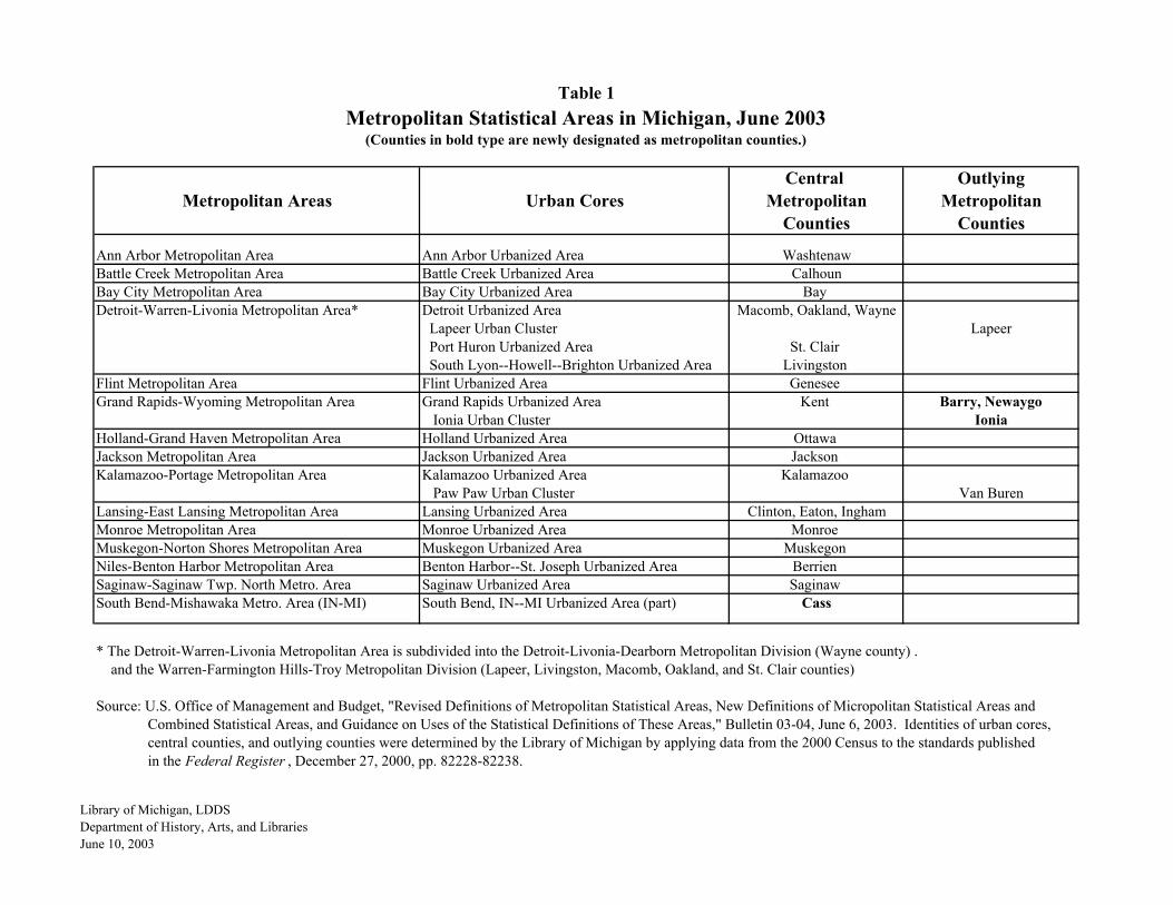
Central OutlyingMetropolitan Areas Urban Cores Metropolitan Metropolitan
Counties Counties
Ann Arbor Metropolitan Area Ann Arbor Urbanized Area WashtenawBattle Creek Metropolitan Area Battle Creek Urbanized Area CalhounBay City Metropolitan Area Bay City Urbanized Area Bay Detroit-Warren-Livonia Metropolitan Area* Detroit Urbanized Area Macomb, Oakland, Wayne
Lapeer Urban Cluster Lapeer Port Huron Urbanized Area St. Clair South Lyon--Howell--Brighton Urbanized Area Livingston
Flint Metropolitan Area Flint Urbanized Area Genesee Grand Rapids-Wyoming Metropolitan Area Grand Rapids Urbanized Area Kent Barry, Newaygo
Ionia Urban Cluster IoniaHolland-Grand Haven Metropolitan Area Holland Urbanized Area Ottawa Jackson Metropolitan Area Jackson Urbanized Area Jackson Kalamazoo-Portage Metropolitan Area Kalamazoo Urbanized Area Kalamazoo
Paw Paw Urban Cluster Van BurenLansing-East Lansing Metropolitan Area Lansing Urbanized Area Clinton, Eaton, InghamMonroe Metropolitan Area Monroe Urbanized Area Monroe Muskegon-Norton Shores Metropolitan Area Muskegon Urbanized Area Muskegon Niles-Benton Harbor Metropolitan Area Benton Harbor--St. Joseph Urbanized Area Berrien Saginaw-Saginaw Twp. North Metro. Area Saginaw Urbanized Area Saginaw South Bend-Mishawaka Metro. Area (IN-MI) South Bend, IN--MI Urbanized Area (part) Cass
* The Detroit-Warren-Livonia Metropolitan Area is subdivided into the Detroit-Livonia-Dearborn Metropolitan Division (Wayne county) . and the Warren-Farmington Hills-Troy Metropolitan Division (Lapeer, Livingston, Macomb, Oakland, and St. Clair counties)
Source: U.S. Office of Management and Budget, "Revised Definitions of Metropolitan Statistical Areas, New Definitions of Micropolitan Statistical Areas and Combined Statistical Areas, and Guidance on Uses of the Statistical Definitions of These Areas," Bulletin 03-04, June 6, 2003. Identities of urban cores, central counties, and outlying counties were determined by the Library of Michigan by applying data from the 2000 Census to the standards published in the Federal Register , December 27, 2000, pp. 82228-82238.
Table 1Metropolitan Statistical Areas in Michigan, June 2003
(Counties in bold type are newly designated as metropolitan counties.)
Library of Michigan, LDDSDepartment of History, Arts, and LibrariesJune 10, 2003

Central OutlyingMicropolitan Areas Urban Cores Micropolitan Micropolitan
Counties Counties
Adrian Micropolitan Area Adrian Urban Cluster Lenawee Allegan Micropolitan Area Plainwell--Otsego Urban Cluster Allegan Alma Micropolitan Area Alma Urban Cluster Gratiot Alpena Micropolitan Area Alpena Urban Cluster Alpena Big Rapids Micropolitan Area Big Rapids Urban Cluster Mecosta Cadillac Micropolitan Area Cadillac Urban Cluster Wexford Missaukee Coldwater Micropolitan Area Coldwater Urban Cluster Branch Escanaba Micropolitan Area Escanaba Urban Cluster Delta Houghton Micropolitan Area Houghton Urban Cluster Houghton KeweenawIron Mountain Micropolitan Area (MI-WI) Iron Mountain-Kingsford WI Urban Cluster (part) Dickinson Marquette Micropolitan Area Marquette Urban Cluster Marquette Marinette Micropolitan Area (WI-MI) Marinette WI-Menominee Urban Cluster (part) MenomineeMidland Micropolitan Area Midland Urban Cluster Midland Mount Pleasant Micropolitan Area Mount Pleasant Urban Cluster Isabella Owosso Micropolitan Area Owosso Urban Cluster Shiawassee Sault Ste. Marie Sault Ste. Marie Urban Cluster Chippewa Sturgis Micropolitan Area Sturgis Urban Cluster St. Joseph Traverse City Micropolitan Area Traverse City Urban Cluster Grand Traverse Benzie, Kalkaska, Leelanau
Source: U.S. Office of Management and Budget, "Revised Definitions of Metropolitan Statistical Areas, New Definitions of Micropolitan Statistical Areas and Combined Statistical Areas, and Guidance on Uses of the Statistical Definitions of These Areas," Bulletin 03-04, June 6, 2003. Identities of urban cores, central counties, and outlying counties were determined by the Library of Michigan by applying data from the 2000 Census to the standards published in the Federal Register , December 27, 2000, pp. 82228-82238.
Table 2Micropolitan Statistical Areas in Michigan, June 2003
(Counties in bold type were classified as metropolitan counties prior to June, 2003.)
Library of Michigan, LDDSDepartment of History, Arts, and LibrariesJune 10, 2003

Combined Statistical Areas Component Metro and Micro Areas
Detroit-Warren-Flint CSA Ann Arbor Metropolitan Area WashtenawDetroit-Warren-Livonia Metropolitan Area Lapeer, Livingston, Macomb, Oakland, St. Clair, WayneFlint Metropolitan Area GeneseeMonroe Metropolitan Area Monroe
Grand Rapids-Muskegon-Holland CSA Allegan Micropolitan Area AlleganGrand Rapids-Wyoming Metropolitan Area Barry, Ionia, Kent, NewaygoHolland-Grand Haven Metropolitan Area OttawaMuskegon-Norton Shores Metropolitan Area Muskegon
Lansing-East Lansing-Owosso CSA Lansing-East Lansing Metropolitan Area Clinton, Eaton, InghamOwosso Micropolitan Area Shiawasee
Saginaw-Bay City-Saginaw Twp. North CSA Bay City Metropolitan Area BaySaginaw-Saginaw Twp. North Metropolitan Area Saginaw
Source: U.S. Office of Management and Budget, "Revised Definitions of Metropolitan Statistical Areas, New Definitions of Micropolitan Statistical Areas and Combined Statistical Areas, and Guidance on Uses of the Statistical Definitions of These Areas," Bulletin 03-04, June 6, 2003.
Component Counties
Table 3Combined Statistical Areas in Michigan, June 2003
Library of Michigan, LDDSDepartment of History, Arts, and LibrariesJune 10, 2003

Community Metropolitan Statistical Area in 1993 Metropolitan Statistical Area in 2003Name (if designated as a central city in 1993) (if designated as a metropolitan principal city in 2003)
Ann Arbor Ann Arbor MSA Ann Arbor Metropolitan AreaBattle Creek Kalamazoo-Battle Creek MSA Battle Creek Metropolitan AreaBay City Saginaw-Bay City-Midland MSA Bay City Metropolitan AreaBenton Harbor Benton Harbor MSA Niles-Benton Harbor Metropolitan AreaDearborn Detroit PMSA Detroit-Warren-Livonia Metropolitan AreaDetroit Detroit PMSA Detroit-Warren-Livonia Metropolitan AreaEast Lansing Lansing-East Lansing MSA Lansing-East Lansing Metropolitan AreaFarmington Hills Detroit-Warren-Livonia Metropolitan AreaFlint Flint PMSA Flint Metropolitan AreaGrand Haven Holland-Grand Haven Metropolitan AreaGrand Rapids Grand Rapids-Muskegon-Holland MSA Grand Rapids-Wyoming Metropolitan AreaHolland* Grand Rapids-Muskegon-Holland MSA Holland-Grand Haven Metropolitan AreaJackson Jackson MSA Jackson Metropolitan AreaKalamazoo Kalamazoo-Battle Creek Metropolitan Area Kalamazoo-Portage Metropolitan AreaLansing Lansing-East Lansing MSA Lansing-East Lansing Metropolitan AreaLivonia Detroit-Warren-Livonia Metropolitan AreaMidland** Saginaw-Bay City-Midland MSAMonroe Monroe Metropolitan AreaMuskegon Grand Rapids-Muskegon-Holland MSA Muskegon-Norton Shores Metropolitan AreaNiles Niles-Benton Harbor Metropolitan AreaNorton Shores Muskegon-Norton Shores Metropolitan AreaPontiac Detroit PMSA Detroit-Warren-Livonia Metropolitan AreaPortage Kalamazoo-Portage Metropolitan AreaPort Huron Detroit PMSASaginaw Township North*** Saginaw-Saginaw Twp. North Metro. AreaSaginaw Saginaw-Bay City-Midland MSA Saginaw-Saginaw Twp. North Metro. AreaSouthfield Detroit-Warren-Livonia Metropolitan AreaTaylor Detroit-Warren-Livonia Metropolitan AreaTroy Detroit-Warren-Livonia Metropolitan AreaWarren Detroit-Warren-Livonia Metropolitan AreaWyoming Grand Rapids-Wyoming Metropolitan Area
* Holland is the principal city of the Allegan Micropolitan Area as well as a principal city of the Holland-Grand Haven Metropolitan Area. ** Midland does not appear in this list for 2003 because it is now the principal city of a micrpolitan area rather than a metropolitan area.*** Saginaw Township North is an unincorporated area that was recognized as a Census Designated Place for the 2000 Census.
Source: Based on U.S. Office of Management and Budget, OMB Bulletin 04-03, June 6, 2003, and OMB Bulletin 83-20, June 27, 1983.
Metropolitan Principal Cities Designated in 2003 and Table 4
Corresponding Central Cities Designated in 1993 for Michigan
Library of Michigan / LDDSDepartment of History, Arts, and LibrariesJune 25, 2003

Community Metropolitan Statistical Area in 1993 Micropolitan Statistical Area in 2003Name (if designated as a central city in 1993) (if designated as micropolitan principal city in 2003)
Adrian Adrian Micropolitan AreaAlma Alma Micropolitan AreaAlpena Alpena Micropolitan AreaBig Rapids Big Rapids Micropolitan AreaCadillac Cadillac Micropolitan AreaColdwater Coldwater Micropolitan AreaEscanaba Escanaba Micropolitan AreaHoughton Houghton Micropolitan AreaIron Mountain Iron Mountain Micropolitan Area (MI-WI)Marquette Marquette Micropolitan AreaMidland Saginaw-Bay City-Midland MSA Midland Micropolitan AreaMount Pleasant Mount Pleasant Micropolitan AreaOwosso Owosso Micropolitan AreaSault Ste. Marie Sault Ste. MarieSturgis Sturgis Micropolitan AreaTraverse City Traverse City Micropolitan Area
Source: Based on U.S. Office of Management and Budget, OMB Bulletin 04-03, June 6, 2003, and OMB Bulletin 83-20, June 27, 1983.
Corresponding Central Cities Designated in 1993 for Michigan
Table 5
Micropolitan Principal Cities Designated in 2003 and
Library of Michigan / LDDSDepartment of History, Arts, and LibrariesJune 25, 2003
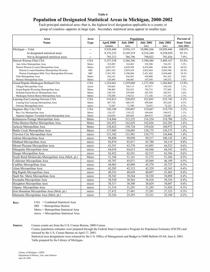
Area Area Percent ofName Type April 2000 July 2000 July 2001 July 2002 State Total
(census) (est.) (est.) (est.) (July 2002)Michigan -- Total -- 9,938,444 9,956,115 10,006,266 10,050,446 100.0% In designated statistical areas -- 9,153,232 9,169,319 9,216,244 9,258,020 92.1% Not in designated statistical areas -- 785,212 786,796 790,022 792,426 7.9%Detroit-Warren-Flint CSA CSA 5,357,538 5,366,296 5,390,484 5,409,167 53.8% Ann Arbor Metropolitan Area Metro 322,895 324,483 329,308 334,351 3.3% Detroit-Warren-Livonia Metropolitan Area Metro 4,452,557 4,458,389 4,474,446 4,484,140 44.6% Detroit-Livonia-Dearborn Metropolitan Division MD 2,061,162 2,059,529 2,052,964 2,045,540 20.4% Warren-Farmington Hills-Troy Metropolitan Division MD 2,391,395 2,398,860 2,421,482 2,438,600 24.3% Flint Metropolitan Area Metro 436,141 436,943 438,800 441,423 4.4% Monroe Metropolitan Area Metro 145,945 146,481 147,930 149,253 1.5%Grand Rapids-Muskegon-Holland CSA CSA 1,254,661 1,259,060 1,273,304 1,284,862 12.8% Allegan Micropolitan Area micro 105,665 106,113 107,877 109,336 1.1% Grand Rapids-Wyoming Metropolitan Area Metro 740,482 742,932 750,733 757,848 7.5% Holland-Grand Haven Metropolitan Area Metro 238,314 239,494 243,528 245,913 2.4% Muskegon-Norton Shores Metropolitan Area Metro 170,200 170,521 171,166 171,765 1.7%Lansing-East Lansing-Owosso CSA CSA 519,415 520,055 522,893 525,742 5.2% Lansing-East Lansing Metropolitan Area Metro 447,728 448,355 450,840 453,620 4.5% Owosso Micropolitan Area micro 71,687 71,700 72,053 72,122 0.7%Saginaw-Bay City CSA CSA 320,196 320,067 319,667 319,759 3.2% Bay City Metropolitan Area Metro 110,157 110,122 109,694 109,672 1.1% Saginaw-Saginaw Township North Metropolitan Area Metro 210,039 209,945 209,973 210,087 2.1%Kalamazoo-Portage Metropolitan Area Metro 314,866 315,232 316,354 318,706 3.2%Niles-Benton Harbor Metropolitan Area Metro 162,453 162,629 162,026 162,285 1.6%Jackson Metropolitan Area Metro 158,422 158,724 159,826 160,972 1.6%Battle Creek Metropolitan Area Metro 137,985 138,085 138,175 138,375 1.4%Traverse City Micropolitan Area micro 131,342 131,981 134,773 136,846 1.4%Adrian Micropolitan Area micro 98,890 99,050 99,517 100,145 1.0%Midland Micropolitan Area micro 82,874 83,017 83,780 84,119 0.8%Mount Pleasant Micropolitan Area micro 63,351 63,370 63,893 64,523 0.6%Marquette Micropolitan Area micro 64,634 64,613 64,566 64,342 0.6%Sturgis Micropolitan Area micro 62,422 62,541 62,515 62,366 0.6%South Bend-Mishawaka Metropolitan Area (Mich. pt.) Metro 51,104 51,161 51,273 51,284 0.5%Coldwater Micropolitan Area micro 45,787 45,871 45,849 46,189 0.5%Cadillac Micropolitan Area micro 44,962 45,098 45,379 45,727 0.5%Alma Micropolitan Area micro 42,285 42,312 42,329 42,365 0.4%Big Rapids Micropolitan Area micro 40,553 40,658 40,897 41,465 0.4%Sault Ste. Marie Micropolitan Area micro 38,543 38,564 38,530 38,898 0.4%Escanaba Micropolitan Area micro 38,520 38,562 38,418 38,336 0.4%Houghton Micropolitan Area micro 38,317 38,308 38,029 38,087 0.4%Alpena Micropolitan Area micro 31,314 31,291 31,245 31,026 0.3%Iron Mountian Micropolitan Area (Mich. pt.) micro 27,472 27,481 27,291 27,325 0.3%Marinette Micropolitan Area (Mich. pt.) micro 25,326 25,293 25,231 25,109 0.2%
Key:
Source:
Table 6
Population
Population of Designated Statistical Areas in Michigan, 2000-2002Each principal statistical area--that is, the highest-level designation applicable to a county or group of counties--appears in large type. Secondary statistical areas appear in smaller type.
Census counts are from the U.S. Census Bureau, 2000 Census.County population estimates were prepared through the Federal State Cooperative Program for Population Estimates (FSCPE) and released by the U.S. Census Bureau on April 17, 2003.Statistical area designations were released by the U.S. Office of Management and Budget in OMB Bulletin 03-04, June 6, 2003.Table prepared by the Library of Michigan.
CSA = Combined Statistical Area MD = Metropolitan District Metro = Metropolitan Statistical Area micro = Micropolitan Statistical Area
Library of Michigan / LDDSDepartment of History, Arts, and LibrariesJune 20, 2003
Library of Michigan / LDDS
Department of History, Arts, and Libraries
June 10, 2003
Metropolitan Areas in Michigan Metropolitan and Micropolitan Areas in MichiganBased on the 1990 Census Based on the 2000 Census
Type of Designation:Central MetropolitanOutlying MetropolitanCentral MicropolitanOutlying Micropolitan
Metropolitan

MICHIGAN COUNTIESMICHIGAN COUNTIES
IRON
DELTA
LUCE
KENT
MARQUETTE
ALGER CHIPPEWA
GOGEBIC
HURON
SANILAC
LAKE
BAY
BARAGA
IONIA
ONTONAGON
MACKINAC
OAKLAND
CASS
ALLEGAN
HOUGHTON
IOSCO
WAYNE
CLARE
TUSCOLA
SAGINAW
MENOMINEE
ALCONA
LAPEER
EATONBARRY
NEWAYGO
SCHOOLCRAFT
ST. CLAIR
LENAWEE
JACKSON
ALPENA
CALHOUN
INGHAM
DICKINSON
MASON
ANTRIM
OTTAWA
GENESEE
EMMET
OSCODA
CLINTON
BERRIEN
OCEANA
GRATIOTMONTCALM
CHEBOYGAN
MONROEBRANCH
OTSEGO
OGEMAW
ISABELLA
OSCEOLA
MIDLANDMECOSTA
HILLSDALE
WEXFORD
GLADWIN
KALKASKA
WASHTENAW
MANISTEE
MACOMB
VAN BUREN
MISSAUKEE
LIVINGSTON
BENZIECRAWFORD
PRESQUE ISLE
KALAMAZOO
MUSKEGON
ST. JOSEPH
ARENAC
ROSCOMMON
SHIAW
ASSEE
MON
TMORENCY
LEELANAU
CHARLEVOIX
KEWEENAW
GRANDTRAVERSE
Produced byMichigan Information CenterOffice of the State Budget
June 29, 2000
001003005007009011013015017019021023025027029031033035037039041043045047049051053055057059061063065067069071073075077079081
ALCONAALGERALLEGANALPENAANTRIMARENACBARAGABARRYBAYBENZIEBERRIENBRANCHCALHOUNCASSCHARLEVOIXCHEBOYGANCHIPPEWACLARECLINTONCRAW FORDDELTADICKINSONEATONEMMETGENESEEGLADWINGOGEBICGRAND TRAVERSEGRATIOTHILLSDALEHOUGHTONHURONINGHAMIONIAIOSCOIRONISABELLAJACKSONKALAMAZOOKALKASKAKENT
LAKELAPEERLEELANAULENAWEELIVINGSTONLUCEMACKINACMACOMBMANISTEEMARQUETTEMASONMECOSTAMENOMINEEMIDLANDMISSAUKEEMONROEMONTCALMMONTMORENCYMUSKEGONNEWAYGOOAKLANDOCEANAOGEMAWONTONAGONOSCEOLAOSCODAOTSEGOOTTAW APRESQUE ISLEROSCOMMONSAGINAWST. CLAIRST. JOSEPHSANILACSCHOOLCRAFTSHIAWASSEETUSCOLAVAN BURENWASHTENAWWAYNEWEXFORD
KEWEENAW083085087089091093095097099101103105107109111113115117119121123125127129131133135137139141143145147149151153155157159161163165