Martini 2011 Zihuatanejo Shortening
12
ABSTRACT Terrane accretion, variations of the con- vergence rate, and interaction with the Carib- bean plate have been proposed as the causes of the Mexican Laramide orogeny. However, the mechanism that triggered this regional deformation event remains unknown. Based on available data, some authors supported the notion that the Laramide shorten- ing migrated from the present-day Pacific coast to the Mexican mainland. However, such migration has been inferred based on paleontologic and isotopic data from the cen- tral and eastern parts of the fold-and-thrust belt, without considering the western part of the orogen. The identification of a chrono- logic pattern of the deformation is crucial to understand the cause of the Laramide orog- eny, because it is a direct consequence of the tectonic process that triggered this regional shortening. Here we present the first structural study of the Zihuatanejo area, which is located in southwestern Mexico, within the interior of the Guerrero composite terrane. Our data document that this region underwent pro- gressive shortening during the Late Creta- ceous, which resulted in regional uplift and unconformable deposition of continental red beds over a Lower Cretaceous marine arc succession. We interpret the continental rocks as the infill of a piggyback basin related to the early evolution of the Laramide orog- eny. According to this scenario, the ~94 Ma age obtained for the oldest continental strata constrains the beginning of the Laramide shortening in the Zihuatanejo area, which was thus the first area of the Laramide belt to be deformed. Considering that during ter- rane accretion the deformation propagates from the suture zone to the continent and terrane interiors, the timing of the Laramide deformation in southern Mexico cannot be explained as a direct consequence of the accretion of the Guerrero terrane. In fact, we document that the Laramide shortening started at the Cenomanian–Turonian bound- ary within the interior of the terrane, and migrated progressively eastward involving the suture belt and the continental mainland. Based on the chronologic pattern docu- mented for the Late Cretaceous–Paleogene shortening in southern Mexico, the Laramide deformation front can be envisioned as a tec- tonic wave that propagates from the present- day Pacific coast to the continental mainland, probably as the result of the increasing sub- duction rate or collision of a Caribbean ter- rane along the Mexican Pacific trench. INTRODUCTION Based on the style and age of deformation, the Late Cretaceous–Early Paleogene shorten- ing structures in southern Mexico have been assimilated to the Laramide orogeny of the North American Cordillera (Campa et al., 1976; Dickinson et al., 1988; Salinas-Prieto et al., 2000; Nieto-Samaniego et al., 2006). Currently, terrane accretion, variations of the convergence rate, and interaction with the Caribbean plate have been proposed as the causes for the Mexi- can Laramide orogeny (Mendoza and Suástegui, 2000; Salinas-Prieto et al., 2000; Keppie, 2004; Cerca et al., 2007; Solari et al., 2007). However, the driving force for this regional shortening event has never been discussed in detail and remains a matter of debate. Only in the past decade the timing, geometry, and kinematics of the structures related to the Laramide orog- eny began to be established in southern Mexico (Cabral-Cano et al., 2000a, 2000b; Elías- Herrera et al., 2000; Salinas-Prieto et al., 2000; Nieto-Samaniego et al., 2006; Cerca et al., 2007; Solari et al., 2007; Martini et al., 2009). Some workers support the notion that the Laramide shortening migrated from west to east during the Late Cretaceous–Early Paleogene (De Cserna et al., 1980; Nieto-Samaniego et al., 2006; Mar- tini et al., 2009). However, such migration has been constrained by paleontologic and isotopic data from the eastern and central fold-and-thrust belt, but no structural study has been presented for the westernmost part. The timing of the Late Cretaceous shortening is crucial to test the ter- rane accretion model as a possible cause for the Laramide deformation. In fact, during the initial stage of terrane accretion the compres- sive stresses are confined along the collisional boundary, resulting in the formation of a strain- localized suture. Subsequently, the deformation eventually propagates away from the suture, producing a wide fold-and-thrust belt that involves the continental mainland and the inte- rior of the terrane. Following such a scenario, rocks of the suture belt should record the oldest deformation, whereas the continental mainland and the terrane interior would be shortened in a subsequent stage, as the result of the progres- sive impingement of the terrane along the conti- nental margin. In this paper we present new structural and U-Pb geochronologic data from the Zihuatanejo area, which is located in southwestern Mexico, within the interior of a large Mesozoic terrane accreted to the North American Pacific margin. Our data improve the definition of the Laramide chronologic pattern in southern Mexico, and per- mit us to test the terrane accretion hypothesis. OVERVIEW OF THE LARAMIDE DEFORMATION IN SOUTHWESTERN MEXICO The Laramide orogeny is represented in southern Mexico by a NNW-SSE to NE-SW fold-and-thrust belt, which extends for ~700 km from the present-day Pacific coast to the Vera- cruz basin (e.g., Nieto-Samaniego et al., 2006) For permission to copy, contact [email protected] © 2011 Geological Society of America 1469 Geosphere; December 2011; v. 7; no. 6; p. 1469–1479; doi:10.1130/GES00743.1; 9 figures; 1 supplemental table. Style and chronology of the Late Cretaceous shortening in the Zihuatanejo area (southwestern Mexico): Implications for the timing of the Mexican Laramide deformation Michelangelo Martini 1, * and Luca Ferrari 1,2 1 Instituto de Geología, Universidad Nacional Autónoma de México, México D.F. 04510, México 2 Centro de Geociencias, Universidad Nacional Autónoma de México, Campus Juriquilla, 76230, Querétaro, México *E-mail: [email protected] on January 14, 2012 geosphere.gsapubs.org Downloaded from
-
Upload
lizbeth-avena-hernandez -
Category
Documents
-
view
224 -
download
1
description
Geologia del Terreno Guerrero
Transcript of Martini 2011 Zihuatanejo Shortening
ABSTRACT
Terrane accretion, variations of the con-vergence rate, and interaction with the Carib-bean plate have been proposed as the causes of the Mexican Laramide orogeny. However, the mechanism that triggered this regional deformation event remains unknown. Based on available data, some authors supported the notion that the Laramide shorten-ing migrated from the present-day Pacifi c coast to the Mexican mainland. However, such migration has been inferred based on paleon tologic and isotopic data from the cen-tral and eastern parts of the fold-and-thrust belt, without considering the western part of the orogen. The identifi cation of a chrono-logic pattern of the deformation is crucial to understand the cause of the Laramide orog-eny, because it is a direct consequence of the tectonic process that triggered this regional shortening.
Here we present the fi rst structural study of the Zihuatanejo area, which is located in southwestern Mexico, within the interior of the Guerrero composite terrane. Our data document that this region underwent pro-gressive shortening during the Late Creta-ceous, which resulted in regional uplift and unconformable deposition of continental red beds over a Lower Cretaceous marine arc succession. We interpret the continental rocks as the infi ll of a piggyback basin related to the early evolution of the Laramide orog-eny. According to this scenario, the ~94 Ma age obtained for the oldest continental strata constrains the beginning of the Laramide shortening in the Zihuatanejo area, which was thus the fi rst area of the Laramide belt to be deformed. Considering that during ter-rane accretion the deformation propagates from the suture zone to the continent and
terrane interiors, the timing of the Laramide deformation in southern Mexico cannot be explained as a direct consequence of the accretion of the Guerrero terrane. In fact, we document that the Laramide shortening started at the Cenomanian–Turonian bound-ary within the interior of the terrane, and migrated progressively eastward involving the suture belt and the continental mainland.
Based on the chronologic pattern docu-mented for the Late Cretaceous–Paleogene shortening in southern Mexico, the Laramide deformation front can be envisioned as a tec-tonic wave that propagates from the present-day Pacifi c coast to the continental mainland, probably as the result of the increasing sub-duction rate or collision of a Caribbean ter-rane along the Mexican Pacifi c trench.
INTRODUCTION
Based on the style and age of deformation, the Late Cretaceous–Early Paleogene shorten-ing structures in southern Mexico have been assimilated to the Laramide orogeny of the North American Cordillera (Campa et al., 1976; Dickinson et al., 1988; Salinas-Prieto et al., 2000; Nieto-Samaniego et al., 2006). Currently, terrane accretion, variations of the convergence rate, and interaction with the Caribbean plate have been proposed as the causes for the Mexi-can Laramide orogeny (Mendoza and Suástegui, 2000; Salinas-Prieto et al., 2000; Keppie, 2004; Cerca et al., 2007; Solari et al., 2007). However, the driving force for this regional shortening event has never been discussed in detail and remains a matter of debate. Only in the past decade the timing, geometry, and kinematics of the structures related to the Laramide orog-eny began to be established in southern Mexico (Cabral-Cano et al., 2000a, 2000b; Elías-Herrera et al., 2000; Salinas-Prieto et al., 2000; Nieto-Samaniego et al., 2006; Cerca et al., 2007; Solari et al., 2007; Martini et al., 2009). Some
workers support the notion that the Laramide shortening migrated from west to east during the Late Cretaceous–Early Paleogene (De Cserna et al., 1980; Nieto-Samaniego et al., 2006; Mar-tini et al., 2009). However, such migration has been constrained by paleontologic and isotopic data from the eastern and central fold-and-thrust belt, but no structural study has been presented for the westernmost part. The timing of the Late Cretaceous shortening is crucial to test the ter-rane accretion model as a possible cause for the Laramide deformation. In fact, during the initial stage of terrane accretion the compres-sive stresses are confi ned along the collisional boundary, resulting in the formation of a strain-localized suture. Subsequently, the deformation eventually propagates away from the suture, producing a wide fold-and-thrust belt that involves the continental mainland and the inte-rior of the terrane. Following such a scenario, rocks of the suture belt should record the oldest deformation, whereas the continental mainland and the terrane interior would be shortened in a subsequent stage, as the result of the progres-sive impingement of the terrane along the conti-nental margin.
In this paper we present new structural and U-Pb geochronologic data from the Zihuatanejo area, which is located in southwestern Mexico, within the interior of a large Mesozoic terrane accreted to the North American Pacifi c margin. Our data improve the defi nition of the Laramide chronologic pattern in southern Mexico, and per-mit us to test the terrane accretion hypothesis.
OVERVIEW OF THE LARAMIDE DEFORMATION IN SOUTHWESTERN MEXICO
The Laramide orogeny is represented in southern Mexico by a NNW-SSE to NE-SW fold-and-thrust belt, which extends for ~700 km from the present-day Pacifi c coast to the Vera-cruz basin (e.g., Nieto-Samaniego et al., 2006)
For permission to copy, contact [email protected]© 2011 Geological Society of America
1469
Geosphere; December 2011; v. 7; no. 6; p. 1469–1479; doi:10.1130/GES00743.1; 9 fi gures; 1 supplemental table.
Style and chronology of the Late Cretaceous shortening in the Zihuatanejo area (southwestern Mexico):
Implications for the timing of the Mexican Laramide deformation
Michelangelo Martini1,* and Luca Ferrari1,2
1Instituto de Geología, Universidad Nacional Autónoma de México, México D.F. 04510, México2Centro de Geociencias, Universidad Nacional Autónoma de México, Campus Juriquilla, 76230, Querétaro, México
*E-mail: [email protected]
on January 14, 2012geosphere.gsapubs.orgDownloaded from
Martini and Ferrari
1470 Geosphere, December 2011
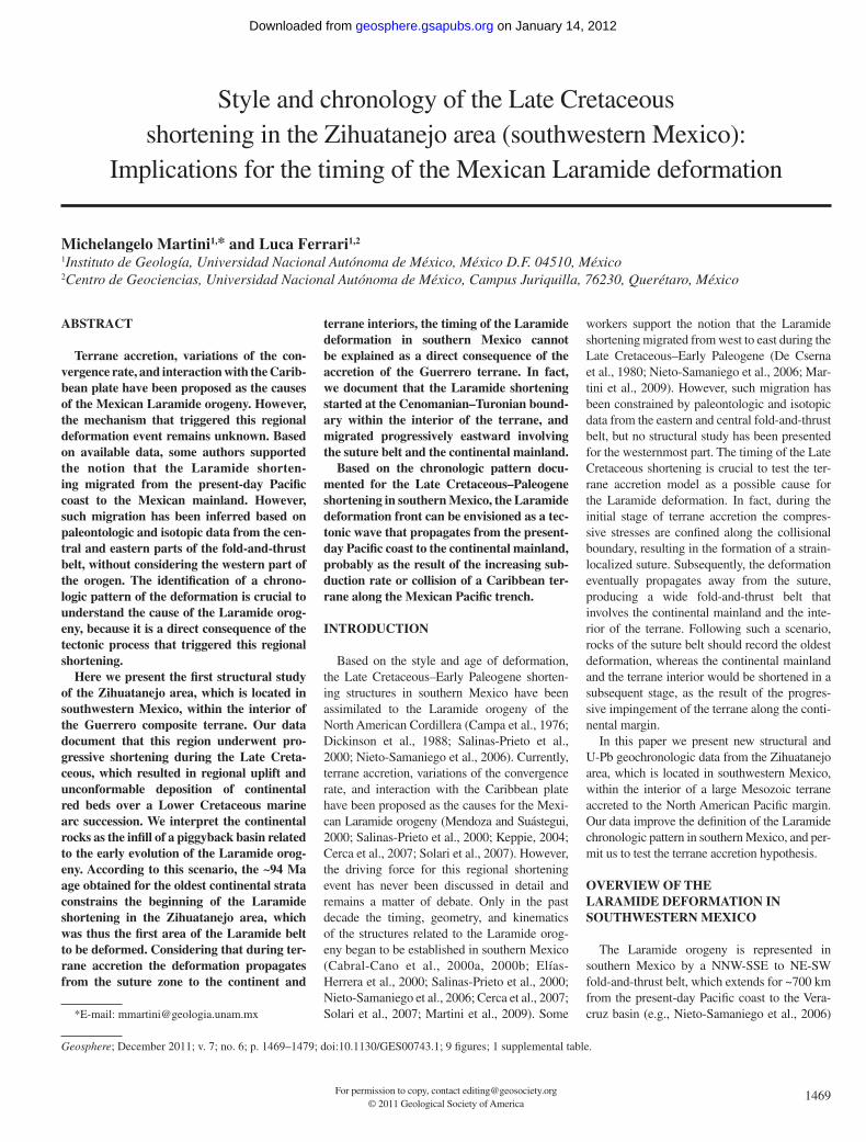
(Figs. 1A and 1B). This paper will focus on the western part of the Laramide belt, where the timing and style of deformation have never been studied in detail. In the following sections we summarize the available data constraining the age of the Laramide shortening, as well as the mechanism proposed for this orogeny.
The Age of the Laramide Deformation
In southwestern Mexico, the timing of the Laramide shortening is best constrained by the age of the infi lls of the foreland basins, which were later deformed and incorporated into the Laramide wedge. According to paleontologic data from the foreland successions, the main shortening took place during the Early Maas-trichtian–Paleocene between Temalac and Atenango del Río, in the Coniacian–Campanian in the Axaxacoalco and Teloloapan areas, and during the Turonian in the Arcelia region (Figs.
1B and 1C) (Guerrero-Suástegui et al., 1991; Hernández-Romano et al., 1997; Lang and Frerichs, 1998; Mendoza and Suástegui, 2000; Perrilliat et al., 2000).
In the Huetamo region (Fig. 1B), rocks deposited in a foreland basin are apparently lacking (Centeno-García et al., 2008; Martini et al., 2009). However, two major Laramidic folding pulses have been recognized in this area (Centeno-García et al., 2008; Martini et al., 2009). The fi rst one caused regional uplift, which produced the end of calcareous sedimen-tation and the unconformable deposition of con-tinental red beds over the marine strata. Scarce paleontologic and isotopic data from the marine and continental successions constrain this event between the late Cenomanian and Santonian (Buitrón-Sánchez and Pantoja-Alor, 1998; Mariscal-Ramos et al., 2005). Although the age of this shortening phase is poorly constrained, available data do not preclude an eastward
migration of the Laramide contractional front. During the Paleocene, a second shortening event gently folded the continental strata and ampli-fi ed the preexisting folds within the marine suc-cession (Martini et al., 2009).
The kinematics and age of the shortening structures along the coastal region, between Zihuatanejo and Manzanillo (Fig. 1A), have not been studied in detail. However, the age of the deformation in this area is critical to defi ne the migration pattern of the Laramide front and, con-sequently, to test the terrane accretion hypothesis.
The Cause for the Laramide Orogeny in Southern Mexico
The mechanism that produced the Laramide orogeny in southern Mexico is poorly under-stood. Several authors considered this regional deformation event to be a result of the accre-tion of a large Mesozoic terrane, the Guerrero
Zihuatanejo
Fold Thrust
Laramide beltUndifferentiated Tertiary volcanics
20°N
W°001W°201W°401
18°N
Zihuatanejo
N
Trans-Mexican Volcanic Belt
0 65 130 km
Pacific Ocean
Study area
HuetamoTeloloapan
Arcelia
Axaxacoalco
Atenangodel Río
Temalac
Guerrero terraneMixteco terrane
Trace of geologic section
Z H A T Axa AR Tm
SW NE WSW ENE WNW ESE
Guerrero terrane Mixteco terrane
Turonian
Coniacian
Early Maastrichtian
Infills of the Laramidic foreland basins
? ?
Veracruz Basin
0 500 1000 km
G MO JX
tleb
edi
mara
Leh
tfot
norF
TMVB
A
B
C
Arteaga
Arteaga Complex
Manzanillo
Figure 1. (A) Tectonic sketch representing the extension of the Mexican Laramide fold-and-thrust belt and the terrane subdivision of Campa and Coney (1983). (B) Schematic tectonic map of southwestern Mexico, showing the distribution of the major Laramidic contractile structures and the localization of the study area. (C) Schematic geologic section across the Laramidic belt, showing the progressive eastward migration of the successions depos-ited in the Laramide foreland basins. J—Juarez terrane; O—Oaxaca terrane; M—Mixteca terrane; X—Xolapa terrane; G—Guerrero terrane; Z—Zihuatanejo area; H—Huetamo area; A—Arcelia area; T—Teloloapan area; Axa—Axaxacoalco area; AR—Atenango del Río area; Tm—Temalac area.
on January 14, 2012geosphere.gsapubs.orgDownloaded from

Late Cretaceous shortening in the Zihuatanejo area (southwestern Mexico)
Geosphere, December 2011 1471
composite terrane (Fig. 1), to the Mexican main-land (Salinas-Prieto et al., 2000; Mendoza and Suástegui , 2000; Keppie, 2004). According to these authors, the suture between the Guerrero terrane and nuclear Mexico is represented by the Teloloapan thrust system, along which the Guer-rero terrane was overthrusted onto the Mesozoic cover of the Mexican craton (Fig. 1).
An alternative scenario suggests that, by analogy with the USA and Canadian Cordillera, the Laramide shortening in southern Mexico could be the result of a period of fl at-slab sub-duction, related to an increase of the convergence rate along the Pacifi c trench (Solari et al., 2007).
Finally, an intriguing scenario has been pro-posed by Cerca et al. (2007). These authors consider that the Laramide shortening may be the result of the entering of the Caribbean plate between North and South America, producing the collision of an arc, an oceanic plateau, or an aseismic ridge with the Mexican Pacifi c margin.
STRATIGRAPHY OF THE ZIHUATANEJO AREA
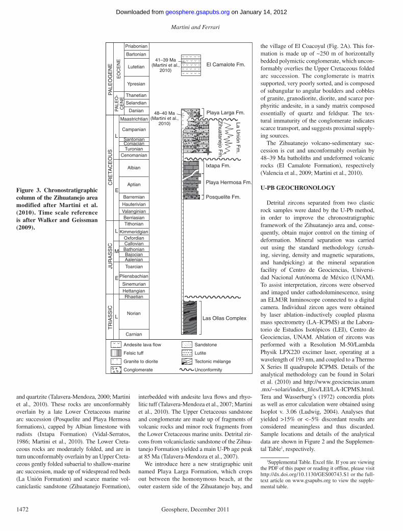
A detailed stratigraphic description of the Zihuatanejo area has been recently presented in Martini et al. (2010). Here we present an
upgrade of such stratigraphic framework, based on new fi eld observations. The areal distribution and geometric relation between the main litho-logic units are shown in the geologic maps of Figure 2. A synthesis of the stratigraphy is pre-sented in Figure 3.
The oldest rocks exposed in the Zihuatanejo area are pre-Cretaceous, polydeformed, quartz-rich metasandstone, phyllite, and schists of the Las Ollas Complex (Centeno-García et al., 2008; Martini et al., 2009). They show a block in matrix texture, and contain decameter- to kilometer-scale slices of banded metagabbro, serpentinite, metabasalt, dunite, plagiogranite,
456
3046
56
3425 33
21
0 10 km
Las Ollas
El Calabacalito
1733
28
Arroyo Seco
3946
28
38
29
La Salitrera
Pantla
S.José Ixtapa
Playa Linda
Zihuatanejo
Ixtapa
17°45′N17°40′N
101°40′W 101°30′W
La Unión
30
24
Feliciano
26 35
37
38 5727
37
38
4838
4150
40.1 ± 0.7 Ma
21
5232
3039
19
Barrancade San Diego
101°40′W102°00′W
Agua Zarca
18°0
0′N
18°1
5′N
20
37
28
0 10 km
Balsas River
Quaternary alluvial and beach sediments
Eocene undifferentiated volcanic rocks
Eocene undifferentiated intrusive rocks
La Unión Formation
Zihuatanejo Formation
Ixtapa FormationPlaya Hermosa Formation
Las Ollas Complex
50 Bedding
Anticline axe trace
Syncline axe trace
Left-lateral fault
Right-lateral fault
Fold axes50
A
Major towns
Playa Larga Formation
El Coacoyul
A
A′
B
B’
Trace of geologic sectionA
A′
U-Pb age (this work)
Playa Larga
PL
UN1
Upper Cretaceous continental to shallow marine arcsuccession
Lower Cretaceous marine arc succession
B N
N
101°20′W
Pacific Ocean
Zihuatanejo
La Unión
Lázaro Cárdenas
Bal
sas
Riv
er NB
17°3
0′N
18°0
0′N
17°4
5′N
18°1
5′N 101°40′W102°00′W
0 20 40 km
A
Unconformity
Figure 2. Detailed geologic maps of the Zihuatanejo (A) and La Unión areas (B), which show the extension of the Mesozoic–Paleogene lithostratigraphic units, the main structures, and the location of the dated samples. Inset shows the geographic location of the mapped areas.
on January 14, 2012geosphere.gsapubs.orgDownloaded from
Martini and Ferrari
1472 Geosphere, December 2011
and quartzite (Talavera-Mendoza, 2000; Martini et al., 2010). These rocks are unconformably overlain by a late Lower Cretaceous marine arc succession (Posquelite and Playa Hermosa formations), capped by Albian limestone with rudists (Ixtapa Formation) (Vidal-Serratos, 1986; Martini et al., 2010). The Lower Creta-ceous rocks are moderately folded, and are in turn unconformably overlain by an Upper Creta-ceous gently folded subaerial to shallow-marine arc succession, made up of widespread red beds (La Unión Formation) and scarce marine vol-caniclastic sandstone (Zihuatanejo Formation),
interbedded with andesite lava fl ows and rhyo-litic tuff (Talavera-Mendoza et al., 2007; Martini et al., 2010). The Upper Cretaceous sandstone and conglomerate are made up of fragments of volcanic rocks and minor rock fragments from the Lower Cretaceous marine units. Detrital zir-cons from volcaniclastic sandstone of the Zihua-tanejo Formation yielded a main U-Pb age peak at 85 Ma (Talavera-Mendoza et al., 2007).
We introduce here a new stratigraphic unit named Playa Larga Formation, which crops out between the homonymous beach, at the outer eastern side of the Zihuatanejo bay, and
the village of El Coacoyul (Fig. 2A). This for-mation is made up of ~250 m of horizontally bedded polymictic conglomerate, which uncon-formably overlies the Upper Cretaceous folded arc succession. The conglomerate is matrix supported, very poorly sorted, and is composed of subangular to angular boulders and cobbles of granite, granodiorite, diorite, and scarce por-phyritic andesite, in a sandy matrix composed essentially of quartz and feldspar. The tex-tural immaturity of the conglomerate indicates scarce transport, and suggests proximal supply-ing sources.
The Zihuatanejo volcano-sedimentary suc-cession is cut and unconformably overlain by 48–39 Ma batholiths and undeformed volcanic rocks (El Camalote Formation), respectively (Valencia et al., 2009; Martini et al., 2010).
U-PB GEOCHRONOLOGY
Detrital zircons separated from two clastic rock samples were dated by the U-Pb method, in order to improve the chronostratigraphic framework of the Zihuatanejo area and, conse-quently, obtain major control on the timing of deformation. Mineral separation was carried out using the standard methodology (crush-ing, sieving, density and magnetic separations, and handpicking) at the mineral separation facility of Centro de Geociencias, Universi-dad Nacional Autónoma de México (UNAM). To assist interpretation, zircons were observed and imaged under cathodoluminescence, using an ELM3R luminoscope connected to a digital camera. Individual zircon ages were obtained by laser ablation–inductively coupled plasma mass spectrometry (LA–ICPMS) at the Labora-torio de Estudios Isotópicos (LEI), Centro de Geociencias, UNAM. Ablation of zircons was performed with a Resolution M-50/Lambda Physik LPX220 excimer laser, operating at a wavelength of 193 nm, and coupled to a Thermo X Series II quadrupole ICPMS. Details of the analytical methodology can be found in Solari et al. (2010) and http://www.geociencias.unam.mx/~solari/index_fi les/LEI/LA-ICPMS.html. Tera and Wasserburg’s (1972) concordia plots as well as error calculation were obtained using Isoplot v. 3.06 (Ludwig, 2004). Analyses that yielded >15% or <–5% discordant results are considered meaningless and thus discarded. Sample locations and details of the analytical data are shown in Figure 2 and the Supplemen-tal Table1, respectively.
41–39 Ma(Martini et al.,
2010)
Las Ollas Complex
Maastrichtian
Campanian
SantonianConiacianTuronian
Cenomanian
Albian
Aptian
Barremian
Hauterivian
ValanginianBerriasianTithonian
KimmeridgianOxfordianCallovianBathonianBajocianAalenian
Toarcian
Pliensbachian
Sinemurian
HettangianRhaetian
Norian
Carnian
SU
OE
CAT
ER
C
L
E
CIS
SA
RUJ
L
E
M
CIS
SAI
RT
L
Danian
Selandian
Thanetian
Ypresian
Lutetian
Bartonian
Priabonian
EN
EG
OEL
AP
EN
EC
OE
-O
ELA
PE
NE
C
Posquelite Fm.
Playa Hermosa Fm.
Ixtapa Fm.
.m
Foj
enat
auhi
Z
.m
Fnó
i nU
aL
Playa Larga Fm.
El Camalote Fm.
48 40 Ma(Martini et al.,
2010)
–
Andesite lava flow
Felsic tuff
Granite to diorite
Conglomerate
Sandstone
Lutite
Tectonic mélange
Unconformity
Figure 3. Chronostratigraphic column of the Zihuatanejo area modified after Martini et al. (2010). Time scale reference is after Walker and Geissman (2009).
1Supplemental Table. Excel fi le. If you are viewing the PDF of this paper or reading it offl ine, please visit http://dx.doi.org/10.1130/GES00743.S1 or the full-text article on www.gsapubs.org to view the supple-mental table.
on January 14, 2012geosphere.gsapubs.orgDownloaded from
Late Cretaceous shortening in the Zihuatanejo area (southwestern Mexico)
Geosphere, December 2011 1473
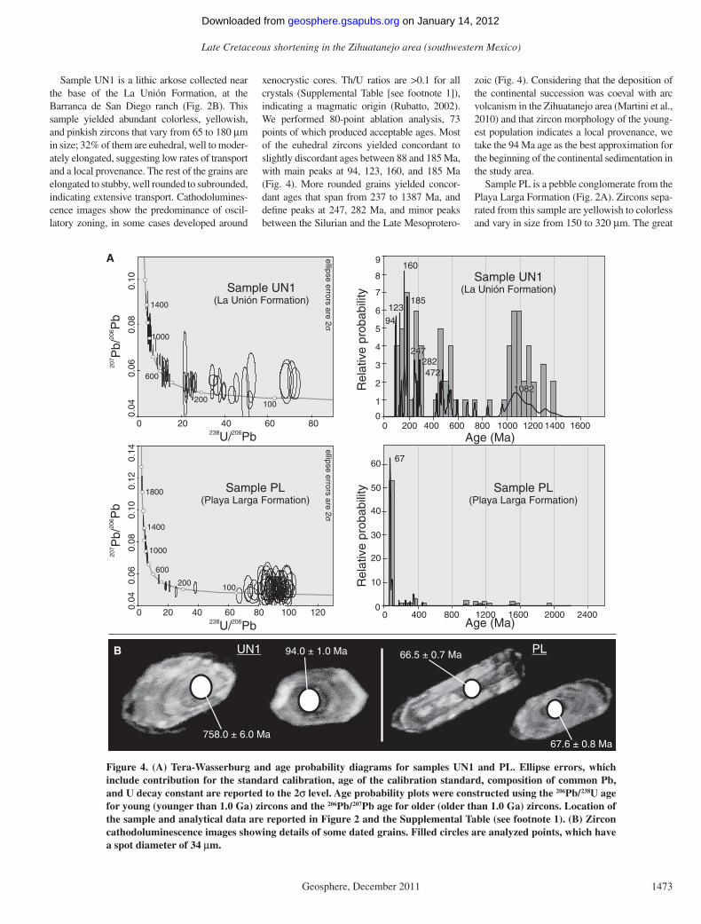
Sample UN1 is a lithic arkose collected near the base of the La Unión Formation, at the Barranca de San Diego ranch (Fig. 2B). This sample yielded abundant colorless, yellowish, and pinkish zircons that vary from 65 to 180 μm in size; 32% of them are euhedral, well to moder-ately elongated, suggesting low rates of transport and a local provenance. The rest of the grains are elongated to stubby, well rounded to subrounded, indicating extensive transport. Cathodolumines-cence images show the predominance of oscil-latory zoning, in some cases developed around
xenocrystic cores. Th/U ratios are >0.1 for all crystals (Supplemental Table [see footnote 1]), indicating a magmatic origin (Rubatto, 2002). We performed 80-point ablation analysis, 73 points of which produced acceptable ages. Most of the euhedral zircons yielded concordant to slightly discordant ages between 88 and 185 Ma, with main peaks at 94, 123, 160, and 185 Ma (Fig. 4). More rounded grains yielded concor-dant ages that span from 237 to 1387 Ma, and defi ne peaks at 247, 282 Ma, and minor peaks between the Silurian and the Late Mesoprotero-
zoic (Fig. 4). Considering that the deposition of the continental succession was coeval with arc volcanism in the Zihuatanejo area (Martini et al., 2010) and that zircon morphology of the young-est population indicates a local provenance, we take the 94 Ma age as the best approximation for the beginning of the continental sedimentation in the study area.
Sample PL is a pebble conglomerate from the Playa Larga Formation (Fig. 2A). Zircons sepa-rated from this sample are yellowish to colorless and vary in size from 150 to 320 μm. The great
602702
bP
/ bP
40. 060. 0
80. 001. 0
21. 041. 0
0 20 40 60 80 100 120
Sample PL(Playa Larga Formation)
238 206U/ Pb
0
10
20
30
40
50
60
400 8000 1200 1600 2000 2400
ytilibabor pevit al e
R
Age (Ma)
Sample PL(Playa Larga Formation)
67
602702
bP
/ bP
238 206U/ Pb
ytilibabor pevit al e
R
Age (Ma)0 20 40 60 80
40.060. 0
80. 001. 0 Sample UN1
(La Unión Formation)
0
1
2
3
4
5
6
7
8
9
Sample UN1(La Unión Formation)
160
123
94
185
282247
472
1082
2000 400 600 800 1000 1200 1400 1600
1000
600
200
1400
100
100200
600
1000
1400
1800
σ2er
asr
orr e
espil
l e2
era
sror
r ees
pill e
σ
A
B 94.0 ± 1.0 Ma
758.0 ± 6.0 Ma
66.5 ± 0.7 MaUN1 PL
67.6 ± 0.8 Ma
Figure 4. (A) Tera-Wasserburg and age probability diagrams for samples UN1 and PL. Ellipse errors, which include contribution for the standard calibration, age of the calibration standard, composition of common Pb, and U decay constant are reported to the 2σ level. Age probability plots were constructed using the 206Pb/238U age for young (younger than 1.0 Ga) zircons and the 206Pb/207Pb age for older (older than 1.0 Ga) zircons. Location of the sample and analytical data are reported in Figure 2 and the Supplemental Table (see footnote 1). (B) Zircon cathodoluminescence images showing details of some dated grains. Filled circles are analyzed points, which have a spot diameter of 34 μm.
on January 14, 2012geosphere.gsapubs.orgDownloaded from
Martini and Ferrari
1474 Geosphere, December 2011
majority of them are euhedral and prismatic, suggesting low rates of transport. Zircons are highly elongated to stubby, with a width/length ratio that spans from 1:5 to 1:1.5. Cathodolumi-nescence images show a continuous oscillatory zoning for all crystals. Th/U ratios are >0.09 (Supplemental Table [see footnote 1]), indi-cating a magmatic origin (Rubatto, 2002). We performed 89-point analysis, 72 points of which produced concordant to slightly discordant ages from 62 to 1948 Ma, with a single major peak at 67 Ma (Fig. 4). Jurassic to Proterozoic ages rep-resent 26% of the determinations, and produce subordinate peaks (Fig. 4). Based on these data, the deposition of the Playa Larga Formation is constrained between 67 Ma, age of the young-est zircons population, and the 42 Ma U-Pb age reported for a granitic intrusive cutting the con-glomerate (Valencia et al., 2009).
SHORTENING DEFORMATION IN THE ZIHUATANEJO AREA
The volcano-sedimentary succession of the Zihuatanejo area records multiple phases of short-ening during the Mesozoic. In this section we present a detailed geometrical description and a
statistical analysis of the main shortening events. Major structures are depicted in the geologic maps of Figure 2. Structural sections and stereo-graphic projections are shown in Figures 5, 6, and 7 to illustrate the geometry of the deformation.
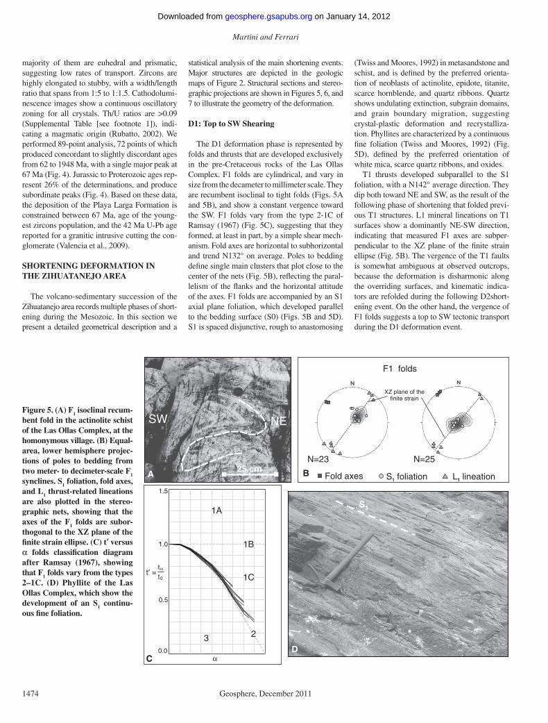
D1: Top to SW Shearing
The D1 deformation phase is represented by folds and thrusts that are developed exclusively in the pre-Cretaceous rocks of the Las Ollas Complex. F1 folds are cylindrical, and vary in size from the decameter to millimeter scale. They are recumbent isoclinal to tight folds (Figs. 5A and 5B), and show a constant vergence toward the SW. F1 folds vary from the type 2-1C of Ramsay (1967) (Fig. 5C), suggesting that they formed, at least in part, by a simple shear mech-anism. Fold axes are horizontal to subhorizontal and trend N132° on average. Poles to bedding defi ne single main clusters that plot close to the center of the nets (Fig. 5B), refl ecting the paral-lelism of the fl anks and the horizontal attitude of the axes. F1 folds are accompanied by an S1 axial plane foliation, which developed parallel to the bedding surface (S0) (Figs. 5B and 5D). S1 is spaced disjunctive, rough to anastomosing
(Twiss and Moores, 1992) in metasandstone and schist, and is defi ned by the preferred orienta-tion of neoblasts of actinolite, epidote, titanite, scarce hornblende, and quartz ribbons. Quartz shows undulating extinction, subgrain domains, and grain boundary migration, suggesting crystal-plastic deformation and recrystalliza-tion. Phyllites are characterized by a continuous fi ne foliation (Twiss and Moores, 1992) (Fig. 5D), defi ned by the preferred orientation of white mica, scarce quartz ribbons, and oxides.
T1 thrusts developed subparallel to the S1 foliation, with a N142° average direction. They dip both toward NE and SW, as the result of the following phase of shortening that folded previ-ous T1 structures. L1 mineral lineations on T1 surfaces show a dominantly NE-SW direction, indicating that measured F1 axes are subper-pendicular to the XZ plane of the fi nite strain ellipse (Fig. 5B). The vergence of the T1 faults is somewhat ambiguous at observed outcrops, because the deformation is disharmonic along the overriding surfaces, and kinematic indica-tors are refolded during the following D2short-ening event. On the other hand, the vergence of F1 folds suggests a top to SW tectonic transport during the D1 deformation event.
A B
SW NE
25 cm
F1 folds
N=23 N=25
Fold axes S foliation1
S1
D
t′ =tα
t0
1.5
1.0
0.5
0.0
3
1A
1B
2
1C
αC
XZ plane of thefinite strain
L lineation1
Figure 5. (A) F1 isoclinal recum-bent fold in the actinolite schist of the Las Ollas Complex, at the homonymous village. (B) Equal-area, lower hemisphere projec-tions of poles to bedding from two meter- to decimeter-scale F1 synclines. S1 foliation, fold axes, and L1 thrust-related lineations are also plotted in the stereo-graphic nets, showing that the axes of the F1 folds are subor-thogonal to the XZ plane of the fi nite strain ellipse. (C) t′ versus α folds classifi cation diagram after Ramsay (1967), showing that F1 folds vary from the types 2–1C. (D) Phyllite of the Las Ollas Complex, which show the development of an S1 continu-ous fi ne foliation.
on January 14, 2012geosphere.gsapubs.orgDownloaded from
Late Cretaceous shortening in the Zihuatanejo area (southwestern Mexico)
Geosphere, December 2011 1475
F Feliciano anticline2 :
N=421000
m
Ix PH
Un
NESW
Section AA′
2000
0 Un
Ti
Measured fold axesPH: Playa Hermosa FormationIx: Ixtapa Formation
Un: La Union FormationTi: Eocene intrusiveTL: Eocene lava flow
S2 axial plane foliationLOC: Las Ollas Complex
A
m
0
1000
LOCIxPH
SW NE SSW NNE
Un TL
Ti
BSection BB′F2 : La Salitrera synclineN
N=58
(Playa Hermosa andIxtapa formations)
(La Unión Formation)
N=57
Figure 6. Geologic sections across the Feliciano kilometer-scale anti-cline (A) and the La Salitrera syncline (B), which illustrate the geometry of the major structures recognized on the fi eld. Sections are built perpendicular to the axes of the main structures. Traces of sec-tions are in Figure 2. Equal-area pole to bedding projections show the variation in the interlimb angle between F2 folds developed in the Lower Cretaceous marine rocks and in the Upper Cretaceous continental succession.
ENWS
A
S0-S1
S2
2 mm
S2
S0-S1
C
t′ =tαt0
1.5
1.0
0.5
0.0
1A
3
1B
2
1C
α
F2 decimeter-scale Laramidic folds
Measured fold axesS2 axial plane foliation
N=48
(Las Ollas Complex)
B
D E
Figure 7. (A) F2 upright folds in the Las Ollas Complex. (B) Equal-area, lower hemisphere projections of poles to bedding from decimeter-scale F2 anticlines and synclines. S1 foliation and fold axes are also plotted in the stereo-graphic nets. (C) t′ versus α folds classifi cation diagram after Ramsay (1967), showing that F2 folds vary from the types 1B to 2. (D) Detail of the S1 and S2 foliations in the actinolite schist of the Las Ollas Complex. (E) Photomicro-graph of a polydeformed quartz-schist of the Las Ollas Complex showing the superposition of the S2 crenulation cleavage on the S1 foliation. Photographed using parallel-polarized light.
on January 14, 2012geosphere.gsapubs.orgDownloaded from
Martini and Ferrari
1476 Geosphere, December 2011
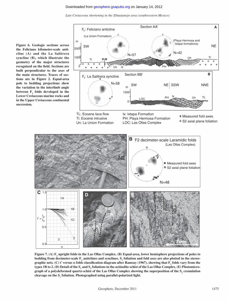
D2: NE-SW Shortening
The most remarkable features of the study area are NW-SE–trending folds that involve both the Cretaceous volcano-sedimentary succession and the Las Ollas Complex. F2 folds are cylin-drical and mostly symmetrical upright (Figs. 6, 7A, and 7B). In the Las Ollas Complex and the Lower Cretaceous marine succession, they vary in size from the millimeter to the kilometer scale, and show interlimb angles between 60° and 115°. In contrast, in the Upper Cretaceous rocks they developed from the decameter to the kilome ter scale, with interlimb angles vary-ing from 120° to 140° (Fig. 6). Sandstone and metasandstone competent layers develop 1B to 1C fold type of Ramsay (1967), whereas 1C to 2 types are characteristic of incompetent lutite and phyllite layers (Fig. 7C). F2 axial planes are ver-tical to moderately inclined, with a N141° main direction. Scarce NW-SE moderately recum-bent folds are also observed, showing a constant vergence toward the NE. F2 axes are horizon-tal to gently SE dipping, and show an average direction of N138° (Figs. 6 and 7B). In the surroundings of La Unión and Zihuatanejo, F2 axes display a sigmoidal geometry in plan view (Fig. 2), which results from the local clockwise rotation of the D2 structures during a subsequent post-D2 right-lateral deformation. The latter is not the subject of this work and will be treated in
a separate paper. Poles to bedding of kilometric F2 folds at Feliciano and La Salitrera areas (Figs. 2 and 6) cluster symmetrically in the NE and SW quadrants, refl ecting the cylindrical nature of these structures and the horizontal attitude of the fold axes. Stereographic projections of these major structures are similar, suggesting that F2 folds formed during a homogeneous NE-SW regional shortening. Scarce mechanic striae on the fold limbs surfaces indicate that F2 structures formed, at least in part, by fl exural slip.
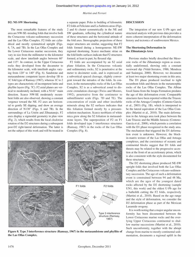
F2 folds are accompanied by an S2 axial plane foliation. In the Cretaceous volcanic and sedimentary rocks, S2 is penetrative at the meter to decimeter scale, and is expressed as a subvertical spaced cleavage, slightly conver-gent toward the intradox of the folds. In con-trast, in the metamorphic rocks of the Las Ollas Complex, S2 is as a subvertical zonal to dis-crete crenulation cleavage (Twiss and Moores, 1992), penetrative from the centi meter to submillimeter scale (Figs. 7D and 7E). The concentration of oxide and other insoluble minerals along the S2 surfaces indicates that this foliation formed mostly by a pressure-solution mechanism. Scarce neoblasts of white mica grew along the S2 foliation in metasand-stone layers. The superposition of F2 on F1 folds developed type 3 interference structures (Ramsay, 1967) in the rocks of the Las Ollas Complex (Fig. 8).
DISCUSSION
The integration of our new U-Pb ages and structural analysis with previous data provides a more coherent interpretation of the deformation history and tectonics of southwestern Mexico.
The Shortening Deformation in the Zihuatanejo Area
Previous studies briefl y described the Meso-zoic rocks of the Zihuatanejo region as essen-tially undeformed, showing only a constant westward dip (Vidal-Serratos, 1986; Mendoza and Suástegui, 2000). However, we document at least two major shortening events in this area.
The D1 phase produced isoclinal to tight recumbent folds and thrusts in the metamorphic rocks of the Las Ollas Complex. The Albian fossil fauna from the Ixtapa Formation predates the age of this deformation event. Comparable structures have been reported within the Triassic rocks of the Arteaga Complex (Centeno-García et al., 2003) (Fig. 1B), which is interpreted to be the lateral equivalent of the Las Ollas Com-plex (Martini et al., 2010). The main deforma-tion in the Arteaga area took place between the Late Triassic and the Middle Jurassic (Centeno-García et al., 2008), which permits a correlation with the D1 phase recognized in the study area. The mechanism that triggered the D1 deforma-tion event is unknown. However, the block-in-matrix texture of the Las Ollas and Arteaga complexes, and the coexistence of oceanic and continental blocks suggest that D1 folds and thrusts may be related to the progressive accre-tion at the front of an accretionary prism, which is also consistent with the style documented for these structures.
The D2 shortening phase produced NE-SW upright folds that involved both the Las Ollas Complex and the Cretaceous volcano-sedimen-tary succession. The age of such a deformation event is constrained between 94 and 48 Ma, which are the ages of the youngest dated rocks affected by the D2 shortening (sample UN1, this work) and the oldest U-Pb age for a batholith cutting the F2 folds, respectively (Martini et al., 2010). Based on the age range and the style of deformation, we consider the D2 deformation phase as part of the Mexican Laramide orogeny.
It is worth noting that a major angular uncon-formity has been documented between the Lower Cretaceous marine rocks and the over-lying Upper Cretaceous continental to shal-low marine successions (Martini et al., 2010). Such unconformity, together with the abrupt change from marine to mostly continental sedi-mentation, documents a regional uplift in the
S0-S1
F2 axial plane
F1 axial plane
S0
F1 folds F2 folds
Type 3 interferencestructure (Ramsay,
1967)
Figure 8. Type 3 interference structure (Ramsay, 1967) in the metasandstone and phyllite of the Las Ollas Complex.
on January 14, 2012geosphere.gsapubs.orgDownloaded from
Late Cretaceous shortening in the Zihuatanejo area (southwestern Mexico)
Geosphere, December 2011 1477
Zihuatanejo area. Effects of the progressive uplift are recorded by the clastic rocks of the La Union, Zihuatanejo, and Playa Larga for-mations. In fact, sandstone and conglomerate of the La Union and Zihuatanejo formations are dominantly composed of fragments of vol-canic rocks and other less abundant lithologies proceeding from the Lower Cretaceous marine succession. Detrital zircons from two sand-stones of these formations show Th/U ratios typical of magmatic origin, and main peaks at 94 Ma (sample UN1, this work) and 85 Ma (Talavera-Mendoza et al., 2007). In addition, the Playa Larga conglomerate mainly con-sists of granite to diorite cobbles and boulders, and contains detrital zircons with ages mostly comprised between 95 and 62 Ma (sample PL, this work). These data indicate that the clastic rocks that unconformably overlie the Lower Cretaceous marine succession were derived mostly from the erosion of the Late Creta-ceous Zihuatanejo arc. The progressive uplift initially produced the erosion of the Late Cre-taceous volcanic edifi ces that supplied detritus to the La Union and Zihuatanejo formations. Subsequently the exhumation and erosion of the arc roots resulted in the deposition of the Playa Larga Formation. Based on these consid-erations, the beginning of the uplift can be con-strained at ~94 Ma, which is the age that best approximates the beginning of the continental sedimentation in the study area.
The uplift documented in the Zihuatanejo region fi ts temporally with the age range esti-mated for the D2 deformation event. In this sense, the F
2 folds of the study area can be
interpreted in terms of a progressive NE-SW shortening and thickening of the crust. In this scenario , the shortening of the Lower Creta-ceous marine succession started at ~94 Ma, pro-ducing regional uplift in the Zihuatanejo area and the beginning of the continental sedimen-tation. Subsequently, the progressive shorten-ing produced the fl attening and amplifi cation of the earlier F
2 folds and the gentle folding of the
Upper Cretaceous red beds. This interpretation explains the increase in the F
2 interlimb angle
from the Lower to the Upper Cretaceous suc-cessions and justifi es the occurrence of a major unconformity separating rocks with the same style of deformation.
The Laramide Continental Sedimentation in the Zihuatanejo Area
Our data document that the Laramide defor-mation in the Zihuatanejo area started at ~94 Ma, producing progressive shortening and crustal thickening that triggered widespread conti-nental sedimentation. A comparable tectonic
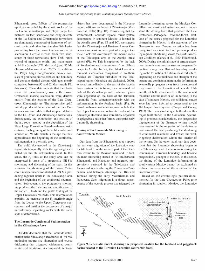
history has been documented in the Huetamo region, ~70 km northeast of Zihuatanejo (Mar-tini et al., 2009) (Fig. 1B). Considering that the westernmost Laramide regional thrust system documented in southern Mexico is located in the Arcelia area (Figs. 1B and 1C), we suggest that the Zihuatanejo and Huetamo Lower Cre-taceous successions were part of a single tec-tonic block that overthrusted the marine rocks of the Teloloapan area at the Arcelia thrust system (Fig. 9). This is supported by the lack of foreland-related successions from Zihua-tanejo to Arcelia. In fact, the oldest Laramidic foreland successions recognized in southern Mexico are Turonian turbidites of the Telo-loapan region (Mendoza and Suástegui, 2000), exposed immediately to the east of the Arcelia thrust system. In this frame, the continental red beds of the Zihuatanejo and Huetamo regions were deposited on the back of the Turonian Laramidic front, contemporaneously with the sedimentation in the foreland basin (Fig. 9). Based on these considerations, we conclude that the Upper Cretaceous continental rocks of the Zihuatenjo-Huetamo area were likely deposited in a piggyback basin that formed during the early Laramidic shortening.
Timing of the Laramide Shortening in Southwestern Mexico
Our data from the Zihuatanejo area support the eastward migration of the Laramide con-tractile front from the western part of the Guer-rero terrane to the Mexican mainland. In fact, the main shortening started at ~94 Ma between Zihuatanejo and Huetamo, and migrated pro-gressively eastward in the Teloloapan and Axaxacoalco areas during the Coniacian–Cam-panian, and between Atenango del Río and Temalac during the early Maastrichtian and Paleocene. Such migration is a direct conse-quence of the tectonic process that triggered the
Laramide shortening across the Mexican Cor-dillera, and must be taken into account to under-stand the driving force that produced the Late Cretaceous–Paleogene fold-and-thrust belt. One of the causes proposed for the Laramide shortening in Mexico is the accretion of the Guerrero terrane. Terrane accretion has been recognized as a main tectonic process produc-ing regional shortening across the North Ameri-can Cordillera (Coney et al., 1980; Hildebrand, 2009). During the initial stage of terrane accre-tion, tectonic compressive stresses are generally confi ned along the collisional boundary, result-ing in the formation of a strain-localized suture. Depending on the thickness and strength of the terrane and continental margin, the deformation eventually propagates away from the suture and may result in the formation of a wide fold-and-thrust belt, which involves the continental mainland and the interior of the terrane. In the case of southern Mexico, the collisional suture zone has been inferred to correspond to the Teloloapan thrust system (Campa and Coney, 1983). The main shortening at both sides of this major fault started in the Coniacian. Accord-ing to previous considerations, the progressive impingement of the Guerrero terrane should have resulted in the migration of the deforma-tion toward the east, producing the shortening of continental mainland, and toward the west, triggering deformation within the interior of the terrane. On the other hand, our data docu-ment that the Laramide shortening began in the Zihuatanejo and Huetamo areas during the Cenomanian–Turonian boundary, and become progressively younger to the east. In this sense, the timing of the Laramide deformation in southwestern Mexico cannot be explained as a direct consequence of the accretion of the Guerrero terrane.
Based on the chronologic pattern docu-mented for the Late Cretaceous–Paleogene shortening in southern Mexico, the Laramide
N
Uplift and continentalsedimentation
Infill of the forelandbasin
mets
ysts
urht
ailec
rA
Teloloapan-Axaxacoalco
area
Zihuatanejo-Huetamo area
Farallon
North AmericaLate Cretaceous arc
Turonian
Figure 9. Schematic sketch showing the proposed location for the foreland and piggyback basins related to the Turonian Laramide contractile front.
on January 14, 2012geosphere.gsapubs.orgDownloaded from

Martini and Ferrari
1478 Geosphere, December 2011
deformation front resembles a tectonic wave that propagates from the present-day Pacifi c coast toward the interior of to the Mexican mainland. This suggests that the Guerrero terrane was already accreted to the Mexican mainland by the Late Cretaceous, and that increasing subduction rates or collision of a Caribbean terrane along the Pacifi c continental margin of Mexico remain available hypotheses to explain the Laramide shortening in southern Mexico.
CONCLUSION
Stratigraphic and structural data, combined with U-Pb geochronology, document a major Laramidic shortening in the Zihuatanejo area. This deformation phase produced progressive folding and regional uplift, which resulted in the fi nalization of the Early Cretaceous marine sedi menta tion, and the unconformable depo-sition of a 2000-m-thick continental succes-sion during the Late Cretaceous. We interpret the continental rocks as the infi ll of a piggy-back basin related to the early evolution of the Laramide orogeny. According to this scenario, the oldest continental strata constrain the begin-ning of the Laramide shortening in the Zihua-tanejo area at ~94 Ma, supporting the eastward migration of the orogenic deformation from the western part of the Guerrero terrane to the Mex-ican mainland. Considering that during terrane accretion the deformation propagates from the suture zone to the continent and terrane interi-ors, the timing of the Laramide deformation in southern Mexico cannot be explained as a direct consequence of the accretion of the Guerrero terrane. In fact, we document that the Laramide shortening started at the Cenomanian–Turonian boundary within the interior of the terrane, and migrated progressively eastward involving the suture belt and the continental mainland. Based on the chronologic pattern documented for the Late Cretaceous–Paleogene shortening in southern Mexico, the Laramide deformation front resembles a tectonic wave that propagates from the present-day Pacifi c coast to the con-tinental interior, probably as the result of the increase in the subduction rates or the colli-sion of a Caribbean terrane along the Mexican Pacifi c trench.
ACKNOWLEDGMENTS
The research was funded by Consejo Nacional de Ciencias y Tecnología (CONACyT) grant SEP 2003-C02-42642 to Luca Ferrari. Juan Tomás Vasquez pre-pared thin sections. We thank Luigi Solari for assis-tance with LA-ICP-MS at Laboratorio de Estudios Isotópicos (LEI). The helpful revisions of Gabriel Chávez-Cabello and an anonymous reviewer greatly improved this manuscript.
REFERENCES CITED
Buitrón-Sánchez, B.E., and Pantoja-Alor, J., 1998, Albian gastropods of the rudist-bearing Mal Paso Formation, Chumbítaro región, Guerrero, Mexico: Revista Mexi-cana de Ciencias Geológicas, v. 15, no. 1, p. 14–20.
Cabral-Cano, E., Draper, G., Lang, H.R., and Harrison, C.G.A., 2000a, Constraining the late Mesozoic and Early Tertiary tectonic evolution of southern Mexico: Structure and deformation history of the Tierra Caliente region: The Journal of Geology, v. 108, p. 427–446, doi:10.1086/314414.
Cabral-Cano, E., Lang, H.R., and Harrison, C.G.A., 2000b, Stratigraphic assessment of the Arcelia-Teloloapan area, southern Mexico: Implication for southern Mexico’s post-Neocomian tectonic evolution: Journal of South American Earth Sciences, v. 13, p. 443–457, doi:10.1016/S0895-9811(00)00035-3.
Campa, M.F., and Coney, P.J., 1983, Tectono-stratigraphic terranes and mineral resource distribution in Mexico: Canadian Journal of Earth Science, v. 20, p. 1040–1051.
Campa, M.F., Oviedo, R., and Tardy, M., 1976, La cabal-gadura laramídica del dominio volcano-sedimentario (Arco de Alisitos-Teloloapan) sobre el miogeosinclinal mexicano en los límites de los estados de Guerrero y México: III Congreso Latino-Americano de Geología, México, Resúmenes, p. 23.
Centeno-García, E., Corona-Chávez, P., Talavera-Mendoza, O., and Iriondo, A., 2003, Geologic and tectonic evolu-tion of the western Guerrero terrane—A transect from Puerto Vallarta to Zihuatanejo, Mexico, in Alcayde, M., and Gómez-Caballero, A., eds., Geologic Tran-sects across Cordilleran Mexico: Puerto Vallarta, Jalisco, Mexico, Guidebook for the fi eld trips of the 99th Geological Society of America Cordilleran Sec-tion Annual Meeting, April 4–7, 2003, Universidad Nacional Autónoma de México, Instituto de Geología, Special Paper 1, p. 201–228.
Centeno-García, E., Guerrero-Suastegui, M., and Talvera-Mendonza, O., 2008, The Guerrero composite terrane of western Mexico: Collision and subsequent rifting in a suprasubduction zone: Geological Society of Amer-ica Special Paper 436, p. 279–308.
Cerca, M., Ferrari, L., López-Martínez, M., Martiny, B., and Iriondo, A., 2007, Late Cretaceous shortening and early Tertiary shearing in the central Sierra Madre del Sur, northern Mexico: Insights into the evolution of the Caribbean–North American plate interaction: Tecton-ics, v. 26, p. TC3007, doi:10.1029/2006TC001981.
Coney, P.J., Jones, D.L., and Monger, J.W.H., 1980, Cor-dilleran suspect terranes: Nature, v. 288, p. 329–333, doi:10.1038/288329a0.
De Cserna, Z., Ortega-Gutiérrez, F., and Palacios-Nieto, M., 1980, Reconocimiento geológico de la parte central de la cuenca del alto Río Balsas, estados de Guerrero y Puebla, En Sociedad Geológica Mexicana, Libro Guía de la excursión geológica a la parte central de la cuenca del alto Río Balsas: V Convención Geológica Nacio-nal, p. 2–33.
Dickinson, W.R., Klute, M.A., Hayes, M.J., Janecke, S.U., Lundin, E.R., McKittrick, M.A., and Olivares, M.D., 1988, Paleogeographic and paleotectonic setting of Laramide sedimentary basins in the central Rocky Mountain region: Geological Society of America Bulletin, v. 100, p. 1023–1039, doi:10.1130/0016-7606(1988)100<1023:PAPSOL>2.3.CO;2.
Elías-Herrera, M., Sánchez-Zavala, J.L., and Macias-Romo, C., 2000, Geologic and geochronologic data from the Guerrero terrane in the Tejupilco area, southern Mexico: New constraints on its tectonic interpretation: Journal of South American Science, v. 13, p. 355–375, doi:10.1016/S0895-9811(00)00029-8.
Guerrero-Suastegui, M., Ramírez-Espinosa, J., Talavera-Mendoza, O., and Campa-Uranga, M.F., 1991, El desarrollo carbonatado del Cretácico Inferior asociado al arco de Teloloapan, Noroccidente del Estado de Guerrero: Pachuca, Convención sobre la evolución Geológica Mexicana, 1er Congreso Mexicano de Min-eralogía Memoir, p. 67–70.
Hernández-Romano, U., Aguilera-Franco, N., Martínez-Medrano, M., and Barceló-Duarte, J., 1997, Guerrero-Morelos platform drowning at the Cenomanian–
Turonian boundary, Huitziltepec area, Guerrero State, southern Mexico: Cretaceous Research, v. 18, p. 661–686, doi:10.1006/cres.1997.0078.
Hildebrand, R.S., 2009, Did Westward Subduction Cause Cretaceous–Tertiary Orogeny in the North American Cordillera?: Geological Society of America Special Paper 457, 71 p.
Keppie, D.J., 2004, Terranes of Mexico revisited: A 1.3 bil-lion year odyssey: International Geology Review, v. 46, p. 765–794, doi:10.2747/0020-6814.46.9.765.
Lang, H.R., and Frerichs, W.E., 1998, New planktic forami-niferal data documenting Coniacian age for Laramide orogeny onset and paleoceanography in southern Mexico: The Journal of Geology, v. 106, p. 635–640, doi:10.1086/516047.
Ludwig, K.R., 2004, Isoplot/Ex, version 3, A geochronologi-cal toolkit for Microsoft Excel: Berkeley Geochronol-ogy Center, Publication no. 4.
Mariscal-Ramos, C., Talavera-Mendoza, O., Centeno-García, E., Morales-Gámez, M., and Benammi, M., 2005, Preliminary magnetostratigraphic study of the upper Cretaceous dinosaur site from La Barranca Los Bonites, Tiquicheo (Michoacán State, southern Mex-ico): Reunión Annual de la Unión Geofísica Mexicana, v. 25, no. 1, p. 57–58.
Martini, M., Ferrari, L., López-Martínez, M., Cerca-Mar-tínez, M., Valencia, V., and Serrano-Duran, L., 2009, Cretaceous–Eocene magmatism and Laramide defor-mation in southwestern Mexico: No role for terrane accretion, in Kay, S.M., Ramos, V.A., and Dickinson, W.R., eds., Backbone of the Americas: Shallow Sub-duction, Plateau Uplift, and Ridge and Terrane Col-lision: Geological Society of America Memoir 204, p. 151–182.
Martini, M., Ferrari, L., López-Martínez, M., and Valencia, V., 2010, Stratigraphic redefi nition of the Zihuatanejo area, southwestern Mexico: Revista Mexicana de Cien-cias Geológicas, v. 27, no. 3, p. 412–430.
Mendoza, O., and Suátegui, M., 2000, Geochemistry and iso-topic composition of the Guerrero terrane (western Mex-ico): Implication for the tectono-magmatic evolution of southwestern North America during the late Meso-zoic: Journal of South American Earth Sciences, v. 13, p. 297–324, doi:10.1016/S0895-9811(00)00026-2.
Nieto-Samaniego, A.F., Alaniz-Álvarez, S.A., Silva-Romo, G., Eguiza-Castro, M.H., and Mendoza-Rosales, C.C., 2006, Latest Cretaceous to Miocene deformation events in the eastern Sierra Madre del Sur, Mexico, inferred from the geometry and age of major struc-tures: Geological Society of America Bulletin, v. 118, no. 1–2, p. 1868–1882.
Perrilliat, M.C., Vega, F., and Corona, R., 2000, Early Maastrichtian mollusca from the Mexcala Formation of the State of Guerrero, southern Mexico: Journal of Paleontology, v. 74, no. 1, p. 7–24, doi:10.1666/0022-3360(2000)074<0007:EMMFTM>2.0.CO;2.
Ramsay, J.G., 1967, Folding and Fracturing of Rocks: New York, McGraw-Hill, 568 p.
Rubatto, D., 2002, Zircon trace element geochemistry: Par-titioning with garnet and the link between U-Pb ages and metamorphism: Chemical Geology, v. 184, p. 123–138, doi:10.1016/S0009-2541(01)00355-2.
Salinas-Prieto, J.C., Monod, O., and Faure, M., 2000, Duc-tile deformations of opposite vergence in the eastern part of the Guerrero terrane (SW Mexico): Journal of South American Earth Sciences, v. 13, p. 389–402, doi:10.1016/S0895-9811(00)00031-6.
Solari, L., Torres de León, R., Hernández Pineda, G., Solé, J., Solís-Pichardo, G., and Hernández-Treviño, T., 2007, Tectonic signifi cance of Cretaceous–Tertiary magmatic and structural evolution of the northern margin of the Xolapa Complex, Tierra Colorada area, southern Mexico: Geological Society of America Bul-letin, v. 119, no. 9–10, p. 1265–1279, doi:10.1130/B26023.1.
Solari, L.A., Gómez-Tuena, A., Bernal, J.P., Pérez-Arvizu, O., and Tanner, M., 2010, U-Pb zircon geochronology by an integrated LA-ICPMS microanalytical work station: Achievements in precision and accuracy: Geostandards and Geoanalytical Research, v. 34, no. 1, p. 5–18.
Talavera-Mendoza, O., 2000, Mélange in southern Mexico: Geochemistry and metamorphism of the Las Ollas
on January 14, 2012geosphere.gsapubs.orgDownloaded from

Late Cretaceous shortening in the Zihuatanejo area (southwestern Mexico)
Geosphere, December 2011 1479
Complex (Guerrero terrane): Canadian Journal of Earth Sciences, v. 13, no. 4, p. 337–354.
Talavera-Mendoza, O., Ruiz, J., Gehrels, G.E., Valencia, V.A., and Centeno-García, E., 2007, Detrital zircon U/Pb geochronology of southern Guerrero and west-ern Mixteca arc successions (southern Mexico): New insights for the tectonic evolution of the southwestern North America during the late Mesozoic: Geological Society of America Bulletin, v. 119, p. 1052–1065, doi:10.1130/B26016.1.
Tera, F., and Wasserburg, G.J., 1972, U-Th-Pb systemat-ics in three Apollo 14 basalts and the problem of ini-
tial Pb in lunar rocks: Earth and Planetary Science Letters, v. 14, p. 281–304, doi:10.1016/0012-821X(72)90128-8.
Twiss, R.S., and Moores, E.M., 1992, Structural Geology: W.H. Freeman and Company, 532 p.
Valencia, V.A., Ducea, M., Talavera-Mendoza, O., Gehrels, G., Ruiz, J., and Shoemaker, S., 2009, U-Pb geo chronol-ogy of granitoids in the northwestern boundary of the Xolapa terrane: Revista Mexicana de Ciencias Geológicas, v. 26, no. 1, p. 189–200.
Vidal-Serratos, R., 1986, Tectónica de la región de Zihua-tanejo, Guerrero, Sierra Madre del Sur [B.S. thesis]:
Instituto Politecnico Nacional, Ciudad de México, México, 155 p.
Walker, J.D., and Geissman, J.W., 2009, Commentary: 2009 Geologic Time Scale: GSA Today, v. 19, p. 60–61, doi:10.1130/1052-5173-19.4-5.60.
MANUSCRIPT RECEIVED 03 AUGUST 2011MANUSCRIPT ACCEPTED 04 AUGUST 2011
on January 14, 2012geosphere.gsapubs.orgDownloaded from

Copyright of Geosphere is the property of Geological Society of America and its content may not be copied or
emailed to multiple sites or posted to a listserv without the copyright holder's express written permission.
However, users may print, download, or email articles for individual use.