MALAYSIA INLAND WATERWAY TRANSPORT SYSTEM · relevant to Sarawak. A natural resource, large rivers...
61
MALAYSIA INLAND WATERWAY TRANSPORT SYSTEM I N S A R A WA K
Transcript of MALAYSIA INLAND WATERWAY TRANSPORT SYSTEM · relevant to Sarawak. A natural resource, large rivers...

M A L A Y S I A I N L A N D W A T E R W A Y
T R A N S P O R T S Y S T E MI N S A R A W A K
SS AABBAAHH MMAAJJUU JJAAYYAA

M A L A Y S I A I N L A N D W A T E R W A Y
T R A N S P O R T S Y S T E MI N S A R A W A K
SS AABBAAHH MMAAJJUU JJAAYYAA

Published by the United Nations Development Programme (UNDP), Malaysia.
© UNDP. All rights reserved.
First published March 2008.
ISBN 983-3904-07-5
United Nations Development ProgrammeWisma UN, Block C, Kompleks Pejabat Damansara,Jalan Dungun, Damansara Heights, 50490 Kuala Lumpur, Malaysia.www.undp.org.my
A catalogue record for this book is available from the Library of UNDP.
The contents may be freely reproduced for non-commercial purposes with attribution to thecopyright holders.
Maps are not authoritative on boundaries.
Design: Thumb-Print Studio Sdn Bhd.

There has been a resurgence in commercial inland waterway transport, particularly for cargo, in Asia andEurope. The major rivers of India, China and Southeast Asia are being used as an alternative to roadtransport in order to achieve greater fuel conservation, reduce emissions of greenhouse gases, and
lower road and vehicle maintenance costs. Experiences of Asian countries, where more sparsely settled areas of rural population have historically
relied on boats for passenger and cargo transport, such as Cambodia, Vietnam, and Thailand, are especiallyrelevant to Sarawak. A natural resource, large rivers like the Mekong, Chao Phraya and Rajang, offer a viableoption to difficult and expensive construction, maintenance and operation of roads, of bridges and vehicles,especially through steep and difficult terrain.
In Sarawak, the road network is still underdeveloped and, unlike Sabah and Peninsular Malaysia, there isno rail network passing through rural areas and connecting the main towns. Under the Ninth Malaysia Plan2006–2010, RM702 million has been allocated to Sarawak to upgrade rural and village roads in order toimprove accessibility and connectivity between rural and urban areas. But building roads is a slow and costlyprocess and, meantime, the state’s rivers can serve efficiently as superhighways from coastal ports into theinterior. In a recent comment reported in The Borneo Post (November 7, 2007), the Chief Minister ofSarawak, Pehin Sri Abdul Taib Mahmud, reiterated this view when he said, ‘Sarawak has many rivers, andwater transportation is always cheaper than land transportation. I think bulk transportation has to beundertaken by water.’
Efficient transport is essential for connecting the rural communities to Sarawak’s larger towns and cities,for reducing isolation, and for providing employment opportunities. And since human needs are not justphysical, effective modes of transport can help increase community interconnectedness and social capital.Furthermore, the promotion of community-based ecotourism along rivers not only provides additionalrevenue for the State, but also generates income for poor communities and helps raise awareness of theneed for sustainable river management.
As elsewhere in Malaysia, the water quality of Sarawak’s rivers is deteriorating. With development, riverpollution has increased and water quality has declined. Polluted rivers affect the health of plants, animals,and human beings. According to data from the Ministry of Natural Resources and Environment, there hasbeen a steady deterioration in the water quality of rivers throughout the country, and the Ninth Malaysia Plan2006–2010, has set aside a huge allocation to help clean them up.
River pollution is caused by discharges of sewage, wastewater, wood waste, toxic chemical waste, heavymarine and spilt oil waste, discarded plastic containers, thermal pollution, accelerated riverbank erosion, andnatural river debris from trees and sedimentation. With appropriate discipline, care and attention, most of theseundesirable impacts can be eliminated, so that we can enjoy and preserve the utility and beauty of our rivers.
The Sarawak Inland Waterway Transport System Study, which supports the preparation of an InlandWaterway Transportation Master Plan, aims to promote the development and use of community watertransport, primarily for the benefit of the rural communities located in scattered settlements along the state’snavigable rivers. At the aggregate level, Sarawak has an enviable record of development, and an overallpoverty level of just 8 percent in 2004. However, development in the rural areas is more limited, and the ruralpoverty rate was 14 percent in 2004. The poor tend to be scattered along the rivers, and it is thesecommunities who potentially stand to benefit most from improvements in river transport.
Besides its advantages in making use of a major accessible resource that is available to all participatingcommunities - the rivers - community water transport is an environmentally friendly, energy efficient and
iii
F o r e w o r d

iv
low-emission mode of transport. Such development has the potential to enhanceeconomic benefits through the increased market activity of more consumer goods movingupstream, and raw materials (coal, logs, agricultural output) and cottage-industryproducts moving downstream. Similarly, access to hospitals, clinics and schools can beimproved, facilitating use of essential services and enhancing the daily lives ofcommunities up and down the rivers.
But the management of community water transport is also a challenge given theunpredictable and sudden changes in the condition of the rivers, the threateningcombination of king tides and heavy rainfall in the river watersheds, and low-water levelsacross rapids and shallow riverbeds during periods of little rainfall. Consequently, thecarrying capacity of the boats, the prospective demand for services, and the boats’operating costs and earning capacity, must all be taken into account.
The study reports on a UNDP supported project designed to encourage improvement inthe safety of boat operations, and cargo and passenger movement on the rivers. Asoperators tend to favour large, high-powered boats and travel at high speeds of 15-25knots (28–56 km per hour) or more, the risk of boat accidents and collisions is high.Furthermore, the supporting rural transport infrastructure is often in need of attention, asterminals, jetties and landing points are often in disrepair, and have precarious, erodedlandward approaches and footholds. Services and the safety provisions need to cater forall users including both the very young and the elderly who are most likely to be accessingschools, clinics and hospitals.
This volume is the seventh in a series of periodic publications reporting on UNDPMalaysia’s work in its energy, environment and human development practice area. Thelarge range of projects being undertaken in this portfolio is designed particularly to supportMalaysia’s efforts to achieve high human development for all its people, to eradicate povertyand ensure environmental sustainability.
I would like to thank the Sarawak State Government, especially to the Sarawak PlanningUnit, the Ministry of Infrastructure Development and Communications, and the SarawakRivers Board for their support in implementing this project. I would especially like to thankmembers of the State Technical Working Committee and the stakeholders for theircommitment to the project. I would also like to express my sincere appreciation to allproject participants and members of the Project Team as listed on page ix, led by Dr. ChungTsung Ping, for their commitment to the success of the project and for putting thispublication together. I sincerely hope that it will be widely read and will increase awarenessof the critical importance of rivers in Sarawak and its role in reducing extreme poverty
Richard Leete PhDResident RepresentativeUnited Nations Development ProgrammeMalaysia, Singapore, and Brunei Darussalam
C o n t e n t s
Foreword
Boxes, Tables, Figures and Maps
Abbreviations and Acronyms
Participants
Development of Infrastructure and TransportationNetworks
A Profile of SarawakThe EconomyThe PeopleThe incidence of poverty
Inland Waterways Are a Major Natural Asset
Conserving and Utilizing Sarawak’s RiversTransport Developments in SarawakMedium-term prospectsThe Sarawak Rivers Board
Policy Framework for Malaysia and Sarawak
The Sarawak Inland Waterway Transport SystemStudy
The Study Methodology
Scope of the Sarawak Inland Waterway TransportMaster Plan
ObjectiveTime Horizon
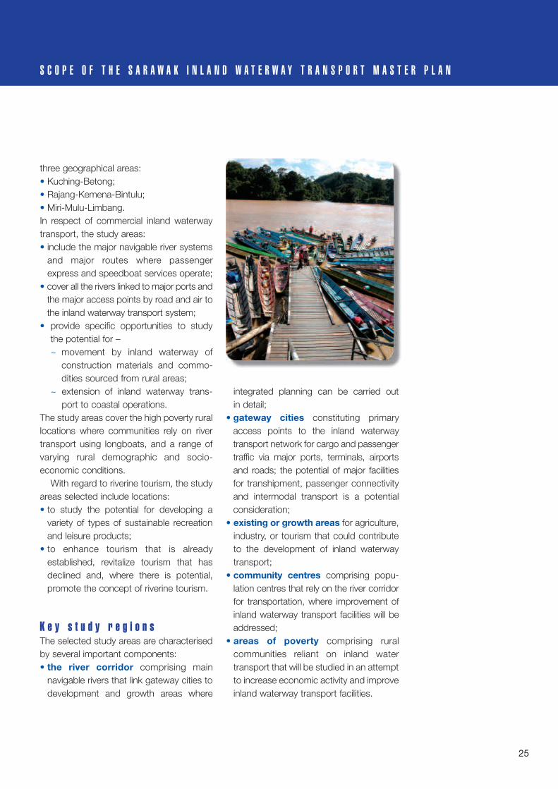
Delineating the Study AreasSelection of Study AreasKey Study Regions
iii
vii
viii
ix
1
3
10
13
16
19
22
24

C o n t e n t s
Addressing Strategies and IssuesEnhancing Commercial Inland Waterway and IntermodalTransport
Supporting Community Water TransportEncouraging Sustainable Riverine TourismImproving Safety and SecurityAdvocating Environmental Sustainability and EnhancementPromoting Institutional Strengthening and Capacity BuildingAdvancing Sustainable Development, Public Participation, Communication Strategy, and Knowledge Management
Two Pilot Projects
Lessons Learnt
Issues and Challenges
Sources of Information
Previous Reports in this UNDP Series
28
43
47
48
49
50

vii
B o x e sBox 1 Advantages and disadvantages of river transport
Box 2 Major developments affecting the river systems
Box 3 Water transport and the Ninth Malaysia Plan, 2006-2010
Box 4 Sarawak Inland Waterway Transport System Study
Box 5 Focus on important components in each study area
Box 6 Stakeholder feedback on promotion of river transportation
Box 7 Public private partnerships
T a b l e sTable 1 Population of Malaysia by region, 1957–2005
Table 2 Ethnic communities in Sarawak, 1960–2000
Table 3 Poverty in states with the highest rates, 2004
Table 4 Sarawak poverty rates by ethnic group, 2004
F i g u r e sFigure 1 Connectedness of the key components of the SIWT Master Plan
Figure 2 Institutional strengthening and capacity building
Figure 3 Construction of pontoon and facilities on Limbang and Mendamit Rivers
M a pMap 1 States and state capitals of Malaysia
Map 2 Major navigable rivers in Sarawak
Map 3 Study areas comprising the inland waterway transport corridor
Map 4 The concept plans for the key study areas
Map 5 Key tourist attractions in Sarawak
Map 6 Community water transport network in Mukah Division
B o x e s , Ta b l e s , F i g u r e s a n d M a p s
viii
A b b r e v i a t i o n s a n d A c r o n y m s
Btg Batang (river)
CWT Community Water Transport
GDP Gross Domestic Product
EPU Economic Planning Unit
ICT Information and Communications Technology
INTIMS Integrated Transport Infrastructure Master Plan for Sarawak
IWT Inland Water Transport
MDGs Millennium Development Goals
NREB Natural Resources and Environment Board
RECODA Regional Corridor Development Authority
RM Malaysian ringgit
SCORE Sarawak Corridor of Renewable Energy
Sg Sungai (river)
SIWT Sarawak Inland Waterway Transport
SPU (Sarawak) State Planning Unit
SRB Sarawak Rivers Board
TC Technical Committee
UNDP United Nations Development Programme
UNESCAP United Nations Economic and Social Commission for Asia and the Pacific

ix
I n s t i t u t i o n a l P a r t i c i p a n t sExecuting Agency Economic Planning Unit, Prime Minister’s Department
State Planning Unit, Chief Minister’s Department
Ministry of Infrastructure Development and Communications
Implementing Agency Sarawak Rivers Board (SRB)
S a r a w a k I n l a n d W a t e r w a y T r a n s p o r t ( S I W T ) P r o j e c t T e a mSRB Chairman Dr. Stephen Rundi a/k Utom
SRB Controller En. Muhamad Yakup bin Kari
SRB Deputy Controller Mr. Teo Swee Ann
SRB Senior Assistant Controller (T&T) En. Hatta Bin Morshidi
SRB Assistant Controller (Legal) Mrs. Dayang Amelia Bte Abg.Hj. Morshidi
Programme Manager Dr Chung Tsung Ping
Project Manager Ms Sharon Ng
Project Assistant Ms Geneve Tan
SRB Planning Team Mr Angga ak Maga
Mr Zehegkiel Piree
En Hazizan Bin Sapiee
R e p o r t T e a mDr Chung Tsung Ping Programme Manager, UNDP
Ms Sharon Ng Project Manager, UNDP
Ms Geneve Tan Project Assistant, UNDP
Professor Warwick Neville University of Auckland, Consultant
S t a k e h o l d e r sEconomic Planning Unit, Prime Minister’s Department
State Planning Unit, Chief Minister’s Department
Ministry of Infrastructure Development and Communication
Ministry of Planning and Resource Management
Public Works Department (JKR)
Ministry of Urban Development and Tourism Sarawak
Natural Resources and Environment Board (NREB)
Lands and Surveys Department Sarawak
Marine Department Sarawak
Riverine Communities of Sarawak
P a r t i c i p a n t s

Historically, patterns of settlement inMalaysia have been strongly influenced bythe physical relief of the country; by itsnatural resources (though actual oil and gasdeposits are largely offshore); tin, forests,and land suitable for agriculture; and morerecently, by the country’s pattern of urbanindustrialization.
On the peninsula, from the mid-nineteenth century, early Malay settlementand subsistence farming on the coastalplains, especially those to the west of themain divide, gave way to plantation cropsand opencast tin mines. And waterbornetransportation along the coast and inlandfor the length of the navigable riverswas soon superseded by road and rail links that followed the north-south grain of the peninsula’s relief. Together with a substantial influx of migrant labour from southern China and south India, the investment of large, international
commercial houses, and acceleratingurbanization, the basic patterns ofeconomic growth and infrastructuredevelopment were well established by mid-twentieth century.
Since gaining independence from Britainin 1957, the west coast states of PeninsularMalaysia have continued to lead Malaysia’s development. The railways, road networks and airports, as well as othercommunication and physical infrastructuresystems, have been at the forefront of thenation’s development, supporting inter-national trade by land, sea (through theStrait of Malacca), and air. These statescontain most of the free trade zones andhave attracted and benefited most from theflow of foreign direct investment and newtechnology supporting economic growth(largely through industrialization) and rapidurbanization from the 1980s onwards. Bycontrast, the communications systems on
1
D e v e l o p m e n t o f I n f r a s t r u c t u r e a n dTr a n s p o r t a t i o n N e t w o r k s

2
the east coast, especially before thediscovery of offshore oil and gas inTerengganu, were much less developed.
The greatest contrast, however, hasbeen with the states of East Malaysia:Sabah and Sarawak. Always sparselypopulated, heavily forested over much oftheir land surface, and with a differentadministrative history that left themrelatively neglected in terms of economicand social development, these two statesare among the least urbanised andindustrialised in Malaysia.
Although their history prior toindependence as part of Malaysia andrelatively sparse population havecontributed to their present level ofdevelopment, the physical character ofSabah and Sarawak has played adominating role in moderating change.Alluvial coastal plains are succeeded inlandby undulating hill country and a sharplyrising mountainous interior. The river valleyflood and coastal plains (mainly peatswamps in Sarawak), form only a smallproportion of the total area, but it is herethat most of the state’s limited settlement,agriculture, road and river transportnetworks are concentrated.
The construction of transport networks inSabah and Sarawak did not occur at thesame scale or time as the establishmentand growth of the road and rail systems inPeninsular Malaysia. The Ninth MalaysiaPlan 2006–2010 acknowledges thisdeficiency and targets ‘expansion ofnetworks to underserved areas as well ascapacity expansion’. Strategies cited in the Plan for infrastructure developmentinclude: enhancing accessibility to qualityinfrastructure facilities in rural areas, to
reduce the urban-rural development gap;providing efficient and reliable services toensure optimal utilisation of infrastructurefacilities; and recognition that ‘rivertransport will continue to support the socio-economic and cultural development ofSarawak. In this regard a study will beconducted to identify the potentials ofdeveloping inland water transport as anefficient alternative mode of transportationas well as promoting tourism.’ That study isthe subject of this volume.
M A L A Y S I A I N L A N D W A T E R W A Y T R A N S P O R T S Y S T E M I N S A R A W A K

The very large tropical island of Borneo isdivided into four political territories: Sarawakand Sabah (both states of Malaysia),Kalimantan (a province of Indonesia), and the independent sultanate of BruneiDarussalam. Soon after the Second WorldWar, Sarawak and Sabah became Britishcolonies and Brunei remained a British-protected sultanate. Set as they were withinan area of emergent nationalism and newlyindependent states, the two Malaysianstates were regarded as politicalanachronisms as they had been before thewar when Sarawak was ruled by a ‘WhiteRajah’, and Sabah by a Chartered Company.
Borneo quickly moved into theinternational limelight in the early postwarperiod because of its huge oil and gaspotential and the changing political status ofthe surrounding countries. Amidst somecontroversy, Sabah and Sarawak, togetherwith Singapore, joined the Federation ofMalaya to form Malaysia. Singaporesubsequently became independent in its
own right, so that Malaysia now comprisesPeninsular Malaysia and the East Malaysianstates of Sarawak and Sabah.
Sabah and Sarawak are separated fromPeninsular Malaysia by the South China Sea,the location of much of the oil and naturalgas wealth of Malaysia and Brunei. With anarea of 124,450 km2, Sarawak is the largeststate in Malaysia, and with some 37.5% ofthe country’s total area is almost as large asthe whole of Peninsular Malaysia. However, ithas less than one-tenth of the country’spopulation, giving it the lowest populationdensity of any state in the country.
The state is divided into elevenadministrative divisions. Each division (oradministrative region) is headed by aResident, and subdivided into between 2and 4 districts. This is a form ofadministrative decentralization to empowerthe Residents and District Officers, heads ofthe civil service administration at thedivisional and district levels respectively, tomake day-to-day decisions.
3
A P r o f i l e o f S a r a w a k
KELANTAN
PAHANG
TERENGGANU
MELAKA
SARAWAK
SABAH
LABUAN
INDONESIA
SINGAPORE
THAILAND
NEGERI SEMBILAN
SELANGOR
PULAUPINANG
PERLISKangar
Georgetown
South China Sea
Strait of Malacca
Sulu Sea
Alor Setar
Ipoh
Kuala LumpurPutrajaya Seremban
Kuantan
Kuala Terengganu
Kota Bahru
Johor Bahru
Kuching
Sibu
Bintulu
Miri
Kota KinabaluSandakan
Tawau
JOHOR
PERAK
KEDAH
International boundaryState (negeri) boundaryState CapitalMajor TownNorth-South HighwayEast-Cost Highway
0 100 200 300KM
N
Map 1 States and state capitals of Malaysia

Sarawak is characterized by anextensive network of navigable rivers thatpotentially form an inland waterwaytransport system. Sarawak has 35gazetted rivers (under the Sarawak RiversOrdinance 93) rivers with a combinedlength of about 5,000 km, of whichapproximately 3,300 km are navigable. TheSungai Rajang, with a length of 567 km, is not only the most important river in Sarawak, but also the longest river inMalaysia. The other major navigable riverscomprise the Sungai Baram, SungaiKemena, Sungai Tatau, Sungai Limbang,Sungai Lupar, Sungai Sadong, and SungaiSarawak (Map 2).
The inland waterway transport system ofSarawak plays a significant role as theprimary means of transportation for a largesection of the population living in the interiorand along the coast, performing functionsthat, in the states of Peninsular Malaysia,
are undertaken mainly by road and rail.Although coastal shipping is not part ofSarawak’s inland waterway transportsystem, it provides an important linkbetween rivers and settlements in theoverall system.
Recognition of the need to developriverine transport in Sarawak supportsUNDP’s view that such infrastructure has adirect and indirect impact on humanpoverty reduction, thus playing a significantrole in the achievement of the MillenniumGoals (MDGs). The impact of developingriverine transportation has the potential todirectly improve access to basic amenitiessuch as health and educational servicesand indirectly enhances economic growth.Furthermore, this study supports nationaland state government plans to furtherdevelop the rivers of Sarawak as a mode of transportation, as noted in the NinthMalaysia Plan, 2006–2010 for example.
4
M A L A Y S I A I N L A N D W A T E R W A Y T R A N S P O R T S Y S T E M I N S A R A W A K

5
A P R O F I L E O F S A R A W A K
T h e e c o n o m ySarawak’s economy is largely export-oriented and dominated by primaryproducts. Primary production, comprisingmainly mining, agriculture and forestry,contributes about 40% of the state’s GDP, with the secondary sector, made up largely of construction and manufacturing,contributing almost 30%.
Sarawak has an abundance of naturalresources, with natural gas and oilconstituting the mainstay of the state’seconomy over several decades. Tropicalhardwood timber has also been a majorrevenue earner, but the imposition of log-production quotas in recent years in orderto manage remaining forests sustainablyfollowing wide-scale deforestation hasintroduced constraints. Nevertheless,Sarawak still produces about 9 to 10 millioncubic metres of logs annually.
Agricultural production other thanforestry and log production is basedpredominantly on rapidly expanding areasof oil palm plantation and, to a lesser extent,on rubber, wet and upland rice, pepper,cocoa and sago. Significant but greatlydiminished proportions of the state remainunder tropical rainforest, parts of which aredesignated as national parks, and togetherwith Sabah, the state’s outstandingbiodiversity attracts ecotourism andinternational scientific attention.
Despite the rapid depletion of timberresources in Sarawak, and mainly becauseof its high production level of oil and naturalgas (from which it receives 5% of the grossvalue) and its relatively diversified economy,the impact on income levels of reduced jobopportunities in logging has been lesssevere than in Sabah, and stringently
controlled immigration flows have avoidedmajor unemployment problems.
Since the 1980s, Sarawak has beenattempting to diversify its economy throughindustrialization. Most of the industrialdevelopment has been based on theprocessing of local natural resources thatinclude the manufacture of hardwoodfurniture, laminated board and specialisedmouldings and joinery; and production ofpetroleum and petrochemicals. The townof Bintulu in particular has developed athriving petrochemical industry, and has thefacilities to cater for an expandedpetrochemical sector.
T h e p e o p l eMalaysia’s population has grown sub-stantially in recent decades with naturalincrease contributing the greater part of the increase in all states. In 2005, Sarawak

was the fourth most populous state, havinggrown at slightly less than the nationalaverage rate, and considerably more slowly than in Sabah, where immigrationhas played a much larger role in populationgrowth. Consequently, despite beingalmost as large as Peninsula Malaysia,Sarawak has less than 9% of the country’stotal population (Table 1).
Sarawak has a large number ofindigenous ethnic groups, most of themwith a distinctive language, culture andlifestyle, plus a substantial Chinese
community that had its early roots in thelarge-scale nineteenth century migration toSoutheast Asia.
By the 2000 Malaysian census ofpopulation, no one group predominated.The Ibans, who are mainly Christians andpredominantly rural, comprised 32% ofSarawak’s population in 1960, but thisshare had fallen to 29% by 2000. TheChinese are the next largest group,accounting for 26% in 2000, also a smallershare than the 31% in 1960, but aproportion similar to that of Chinese in the
6
M A L A Y S I A I N L A N D W A T E R W A Y T R A N S P O R T S Y S T E M I N S A R A W A K
Source: Leete, 2007, Table 2.1.
Year Peninsular Malaysia Sabah Sarawak Malaysia
1957 6,278.8 410.5 693.2 7,382.51970 8,809.5 653.6 976.3 10,439.41980 11,426.6 1,011.0 1,307.6 13,745.21991 14,797.6 1,863.7 1,718.4 18,379.72000 18,523.2 2,679.4 2,071.5 23,274.72005 20,799.8 3,015.2 2,312.6 26,127.7
Table 1 Population of Malaysia by region, 1957–2005
Number (000)
1957 85.0 5.6 9.4 1001970 84.4 6.3 9.4 1001980 83.1 7.4 9.5 1001991 80.5 10.1 9.3 1002000 79.6 11.5 8.9 1002005 79.6 11.5 8.9 100
Distribution (per cent)
1957-1970 2.6 4.7 2.6 2.71970-1980 2.2 3.8 2.4 2.31980-1991 2.4 5.6 2.5 2.61991-2000 2.5 4.0 2.1 2.62000-2005 2.3 2.4 2.2 2.3
Average annual growth rate (per cent)

peninsula. Whilst the proportions of Ibansand Chinese have declined over time, theshare of Malays in Sarawak’s populationhas grown, rising from 17% in 1960 to 22%in 2000 (Table 2).
Chinese and Malays tend to predominatein the state capital of Kuching, and in theother main towns such as Sibu, Miri and Bintulu, whereas the indigenouscommunities are mainly located in the muchless developed rural areas. The isolatedlocation and poverty of many of theindigenous communities is evident in poorhousing, unsafe environmental conditions,inadequate access to health care and muchhigher incidence of malaria than in thepeninsula. Communication systems areless well developed and some ruralcommunities lack access to electricity andclean water.
The sparse and unevenly distributedpopulation of Sarawak in the context of itsvery large size gives rise to significant
7
A P R O F I L E O F S A R A W A K
• food security can be threatened when an area is opened up:~ through loss of land and resources ;
• cash earning opportunities can become available:~ but are dependent on skills, knowledge, wages;
• commercial agricultural cultivation, especially of intensive crops,necessitates:~ significant socio-cultural changes;~ high value, small volume, low weight, transport-tolerant, time-tolerant;~ intemodal bulking agents and facilities;~ cost considerations: multiple handling, transport tolerant;
• improved transport:~ implies increased cash dependence;
• greater role of cash economy:~ impacts to reduce social solidarity and community-based social-security
safety nets;• out-migration, encouraged by isolation and poverty:
~ can make uplift of rural conditions more difficult;~ create new problems economically and socially;~ may raise problems of social regulation.
R e d u c i n g i s o l a t i o n a n d p o v e r t y c a n b e a t o r t u o u s p r o c e s s
1 Before 1991, ‘Others’ included mainly Indians and others, such as Europeans, but from 1991 it also included Filipinos.Source: Leete, 2007, Table 2.4.
Community 1960 1970 1980 1991 2000
Table 2 Ethnic communities in Sarawak, 1960–2000
Malays 17.4 18.6 19.7 21.0 22.3Ibans 31.9 31.1 30.3 29.5 29.1Bidayuhs 7.7 8.6 8.2 8.2 8.0Melanaus 6.0 5.5 5.7 5.7 5.5Other Indigenous 5.1 5.2 5.3 6.1 5.7Chinese 30.8 30.1 29.5 27.7 25.9Others1 1.1 1.0 1.3 0.9 0.4Non-Malaysian no data no data no data 1.1 3.0citizens
Total percent 100.0 100.0 100.0 100.0 100.0Total numbers 744.5 976.3 1,307.6 1,718.4 2,071.5

challenges in the provision of physical andsocial infrastructure, the delivery of social andeconomic services, the restricted possibilitiesof market-based policies for economicexpansion and poverty eradication, and thejustification on a per capita economic basisfor the provision of a modern infrastructureand services.
T h e i n c i d e n c e o f p o v e r t ySarawak has an enviable record in povertyreduction. A poverty incidence of nearly60% of households in 1976 had beenreduced to 8% by 2004. From a conditionmuch worse than the country average,Sarawak is now only a couple ofpercentage points above it (Table 3).However, despite this achievement,Sarawak remains in the bottom half of aranking of states by incidence of poverty,having slipped behind two more states(Kedah and Perlis) since 2002.
In Sarawak, poverty is largely a ruralphenomenon. In 2004, the rural pooraccounted for 90% of the state’s poorhouseholds and for 98% of hardcore poor households. Most of this rural povertyis associated with families working inagriculture. In that same year, thesehouseholds accounted for two-thirds of all poor households in the state, and for70% of the hardcore poor households.
The occurrence of poverty also varies
8
M A L A Y S I A I N L A N D W A T E R W A Y T R A N S P O R T S Y S T E M I N S A R A W A K
Source: Leete, 2007, p.147. Source: Khoo, 2007, Table 12.
State Poverty rate (%)Sabah 23Terengganu 15Kelantan 11Sarawak 8Kedah 7Malaysia 5.7
Table 3Poverty in states with the highest rates,Malaysia 2004
Ethnic group Incidence of Share of state’s Share of poor
poverty (%) households (%) households (%)
Other Bumiputera 17.2 4.5 9.7Bidayuhs 16.6 10.6 21.9Malays 9.0 21.1 23.7Ibans 8.9 28.0 31.1Melanaus 8.3 6.7 6.9Chinese 1.9 28.4 6.7
Table 4 Sarawak poverty rates by ethnic group, 2004

significantly by ethnic group (Table 4). Withan incidence of around 17%, Bidayuhs andOther Bumiputera account for nearly 32%of poor households although they compriseonly 15% of the total. Ibans, Malays and Melanaus, each with an estimatedincidence of around 9%, account for nearly62% of the poor households but comprisejust 56% of all households. Chinesecomprise the largest number of householdsbut have the lowest incidence of householdpoverty. Ibans and Bidayuhs accounted forthe large majority of hardcore poor.
Whilst the poor are overwhelmingly rural,they also tend to be predominantly small-scale agriculture-dependent communitiesthat are generally the least educated, andcommonly average a family size above thenational norm. In addition to financialhardship, the poor face many challengesincluding securing land rights and otherbasic rights to development. Many of theseindigenous communities have low levels ofhuman capital, lack ready access to basicamenities and facilities, and because thephysical infrastructure is underdeveloped inthe areas where they live, they remainpoorly connected to markets. They seem to be locked into an unrelentingintergenerational cycle of poverty, andrequire outside assistance to break free(Leete, 2007).
9
A P R O F I L E O F S A R A W A K

10
I n l a n d W a t e r w a y s A r e A M a j o r N a t u r a l A s s e t
In Sarawak, broadly speaking, two maingroups of rivers drain the state: the largerrivers that flow from the mountain rangesmarking the Sarawak-Kalimantan borderthat constitutes the watershed for all therivers flowing into the South China Sea; andthe short, meandering coastal rivers acrossthe mid-Sarawak lowlands. It is the formergroup, extending far up into the remoteareas of the state, with which this SarawakInland Waterway Transport (SIWT) Study isprimarily concerned.
Before the advent of Europeans in thesixteenth century, the island of Borneo had
belonged to various other island-kingdomsof Southeast Asia that had a very differentperspective on the region. Within this islandworld, ocean and riverine waterways wereperceived as unifying rather than dividing,and the mountain ranges towards thecentre of the islands, not the coasts, werealways regarded as the real frontiers thatseparated and divided.
The rivers of Sarawak have been themain, and often the only, means oftransporting passengers and goods in bothurban and rural areas. River transportpossesses significant advantages when
LABUAN
TELUK BRUNEI(BRUNEI BAY)
Batu Timbul PelongTg PelongP. Muara BK.
Lawas Btg
Bt.Suang
L.Semado
Ulu Trusan
Hulu
S. Madirit G. Murud
BaKalalan
Ruan Tong
S.Dap
urS.
Kela
pang
LAWASLawas
DU
AT
Trusan
Batang
Merapok
L.Sukang
Btg. Limbang
Bt.Ladan
Bt.BatuLawi
Bt. Teraja
Bakung
Tinj
or
Batan
g
S. Baku
ng Bar
om
L. Linel
Tg. Baram
LutongTg. Lobong
TELUK LOAK
Sibuti
L.Miri
Bt. Abandong
S. Dopa
Bt. Batu Song
Pa Tik
Bareo
Bt. Selalap
L. SenialL. Lalang
G. Malapa
Lio Matoh
L. AtipL. Wat
S. Palutan
SilotS.
HuluBoram
S.Aka
h
Niah
S. Sebuti
K. SUAISuai
Btg
Suai
S. Niah
BekanuK. Nyabor
S.Pa
tah
Bt. Nakan
L. Terbangan
Bt. Simang
L.Palai
DATARAN TINGGI USUN
L.Toan G. Panjang
BANJARAN
TAMA
ABU
L. Akah
Bt. Kalulong
Apo Upa
Bt. Lawan
BELAGABt.
Segaham
Bt.Punan
Bt. Ajau
L. Murum
L. Gang
Bt. Bora
Bt. Kayo
Bedian
BAHAGIAN KAPIT
Bt. DamaDATARAN TINGGI
BATU LAGA
G.Kajang
Bt. TasuG. BaningBt. Bakak
SONGKANOWIT
SIBU
BINTANGOR
BAHAGIAN SIBU
SARIKEIJULAU
DARO
MATU
DALAT
Balingian
MUKAHTATAU
K A L I M A N T A N
K.Tatau
Lemai
BINTULU
BAHAGIAN BINTULU
Meluah
BAHAGIAN
Rajang
SalalangMERADONG
SARATOK
Pakan
SRI AMAN
Pantu
Lingga
Bt. Batu
SARIKEI
LUBOK ANTU
Bt. Entimau
BETONG
SAMARAHAN
SIMUNJAN
BAHAGIAN KUCHING
Sematang
Sg. Sematang
Sg. Sarawak
Sg. Santubong
Btg. Samaran Btg. Sadong Btg. SaribasBtg. Rambungan
Btg. Rajang Btg. Igan
Btg. OyaBtg. Balingan
Btg. Kemena
Sg. Similajau
Sg. Sebuti
Sg. Miri
Sg. LimbangSg. Lawas
Btg. Niah
Btg. Baram
Btg. Tatau
Btg. Mukah
Btg. Kayan
SantubongBako
KUCHINGBatu Kawa
BAUKOTA
SAMABAHAN
BAHAGIAN
Asajaya
SERIAN
Mongkos
Tebedu
Tebakang
Balai Ringin
Tg. Serabang
Tg. Datuk
P. SompadiP. Satang
P. Lakei S. Nga
mah
Poi Batang
S.Po
i
Batang Oya
Kabong
Tg. JerijehDurin
Tg. SirikBatang
ya
Btg. Matu
Btg
Lass
a
Tg. Kidurong
Batang
Btg. Mukah
Btg.
S. Anap
S. Posar
Igan
PulauB
ruit
Batang. Mukah
S.Gigis
S. Tamin
Tatau
Bal
ingi
an
Tg. Similajau
S. Penyuan
S. Maliah
S. Murum
S. Seping
Pajang
Batang Bakui
Batang
S.Ba
S. Kakus
S.Se
bauh
K. BINTULU Sebiu
BatangSebauh
Pandan
Labang
Tubau
Bt. Sekiwa
M. L
ASSA
Tg. PoP. Burung
RobangS. Seblak
S. Kerian
Spaoh
Pusa DobakS. Rimbang
Tg. Melaban
S. Maludam
K. SARBAS
K. RAJANG
K. PALOH
K. IGAN
K. MUKAH
K. TATAU
S. Sera
S. Likau
S. Similajau
Kemena
S. Jelalang
S. Kay
an
Beloga
Batang
S. Pandan
S.Tubau
S.Bi
no
K.SADONG
Tg. Batu
G. Puah
G. Berumput
G. Kandai
Bt. Besi
Btg.
Kaya
n
Bt. Gumbang
Bt. Penrisson Padawan
Bt. Meranja Kecil
Bt. RawanBt. Niat
Bt.Balau Hulu
S.Julau
Bt. Besai
Batang
Btg. S
eker
ang
Btg. L
ayar
S.En
gkar
i
Engkari Bt. Biru
Bt. Makup
Bt. Condong
Tintang Kedang
G. Libu
Batang
G. Loi
G. CemaruBt. Batu Tiban
G. Makital
G. Batubulan
S. Bilang
S. Batang Balui
S. Seran
Lebu
wai
S. KajangS. Linau
S. Malarang
S. Linau
S. Kaluan S. Danum
S. PieranS. Ti
yut
S. Bahau
BolehBt. Tunggal
RajangS. Katibas
S. Katibas
S. Mengiong
S. Majau
S. MujangS.Pila
S. Entuloh
S.M
elat
ai
S. Gaat
BatangBoleh
S. Putai
S. GoatS. BalangS. Bangkit
S.En
tulu
G. Meraci
Btg.
Sada
ng
P. Talang-Talang
BAHAGIAN SRI AMANBt. Grogo
Bt. Sengkajau
Bt.Raya
Bt.Sidi
KAPIT
Bt. Kumbong
G.N
IEU
WEN
HUIS
Bt. Jimbong
L.Jawi
BANJARANDULIT
L.Lama
SungaiTutuh
Bat
ang
Beluru
S. Kargo
MIRI
MARUDI
BAHAGIAN MIRI
S. Miri
K. Baram
K. Baram
G. Buda
G. MuluL.
Seridan
Bt.Batu
Patam
L.S. Buang
S. Kubaan
S. MagohBt.
TemalaApoh
S. Medalam
Bt.Ratak
LIMBANG
BRUNEI
BRUNEI
BAHAGIAN LIMBNG
SABAH
BANJARA
NM
ALIG
AN
Limbang
Btg. Matu
M. Sereaeag
S. Simunjan
Kanan
Btg. Kerang
Btg. SaribasBatang Lupar
Btg. Seterap
BANJARAN KELINGKANG
Btg. Sadang
S. Kanowit
S.Ka
hoi
PEGUNUNGAN IRAN
BAN
JARA
NAP
O
G. Puting
LUNDU
Igan
PEGUNUNGANHOSE
Map 2 Major navigable rivers in Sarawak

compared to competing modes oftransport, although it also has somedisadvantages (Box 1).
Until recently, the extensive network ofnavigable rivers provided the main means oftransport between the major urban centresof Kuching, Sibu, Bintulu and Miri, and thewidely patronised means of access forpeople living in many interior districts andvillages. In addition, freight has traditionallybeen transported between the interior andthe main river and sea ports by small shipsand barges. Between 300 and 500 vesselscurrently ply the rivers daily and about halfof these are engaged in the transport ofpassengers, with the remainder involved intransporting bulk and break-of-bulk freight.
In terms of passenger transport,Sarawak has an extensive express boatservice which connects various coastaltowns and the rural areas of the interior thatare, in the main, inaccessible by road.These scheduled services are operated byprivate companies under an authorisedriver transport permit from the SarawakRivers Board with which the timetable andfares are agreed. At present there is noevidence of a formal pricing methodologysuch as average or marginal cost-basedpricing. In practice, fares are determined on
the basis of historical rates moderated byinflationary cost increases and equityconsiderations. Similarly, there are no‘through’ multimodal fares.
Passengers use various modes oftransport for onward travel from express-boat terminals. In urban centres, thesecomprise walking, motorised privatetransport, buses and minivans. Otheractivities involving the river system,especially in urban areas, include shortriver-crossing and cruising trips, and baycrossing. In rural riverine locations, a varietyof methods is used involving privatespeedboats, longboats and smallpaddleboats. With regard to express boatservices, residents frequently state theirconcerns about cost, reliability, comfort andsafety, particularly with regard to embarkingand disembarking at passenger landingsand jetties. At the village level, local peopleoften lack direct access to any basictransport service.
A limited number of new passengerterminals have been built to serve expressboats. However, congestion often occurs,especially during festive seasons whenexpress boats, speedboats, longboats andother craft compete for the limited quayspace available. There are 83 gazetted
11
I N L A N D W A T E R W A Y S A R E A M A J O R N A T U R A L A S S E T
The rivers are of greatsignificance for they as yetprovide the only practicalline of movement. In anundeveloped, forested andhilly country where thereare no integrated road andrail networks, it is notsurprising that most, if notall, the settlements arewholly dependent on rivertransport… Rivers andtracks in most areas formthe link between hinterlandand coast, a circumstancewhich at once results from, and contributes to,the low level of internaldevelopment… Thepresent-day consequenceof this completedependence on waterwaysis the dominance ofcoastal and rivercivilizations, with the bulkof the population livingwithin easy reach of rivers.
Lee, 1970, p.7.
R i v e r s r u l e d t h ew a y o f l i f e

12
wharves and jetties (under the River TrafficRegulation 1993), and available statisticsalso indicate there are over 900 otherfacilities operating in Sarawak. Numeroussmall jetties and piers exist along theriverbanks serving the dispersed villagesettlements. Some are scarcely identifiableas regular jetties, and many are dangerousand in need of repair.
Freight transport comprises a wide rangeof services that include the bulk shipment oflogs, coal and gravel by a variety of meanssuch as: the towing of floating logs; smallbulk carriers; and tug-barge systems.These cargoes are transported to riverineand coastal ports for transhipment todomestic or export destinations. Generalcargoes and provisions are moved in arange of craft, and loaded and dischargedat private and Government wharves andjetties using shipboard and shore-basedcranes. Services are provided either by theshippers themselves, or by privately ownedcommon carriers at negotiated freight rates. Very little use is made of moderncargo-handling or unitized shipmentmethods outside the main ports.
The main ports in Sarawak are inKuching, Sibu, Bintulu, and Miri. The latestaddition, Senari Port, a new deepwater portat Kampung Senari, complements theexisting facilities of the Kuching PortAuthority. All Sarawak’s ports are wellequipped to handle general and bulk cargodry, liquid and gaseous. With the exceptionof Bintulu Port (a deep sea, federal port), all ports are managed by State PortAuthorities. As the state relies heavily onexternal trade for its economic growth, thedevelopment of port facilities is important.Port development will be an essential
element in the creation of an effectiveintermodal system that utilizes inlandwaterways transport to its full potential.
A study developing the first IntegratedTransport Infrastructure Master Plan forSarawak (INTIMS) has been completed andthe Final Report was submitted to the StatePlanning Unit in 2006. The findings of thisstudy provide a broader framework withinwhich the SIWT system will be developedand will be reviewed during the mid-termreview of the Ninth Malaysia Plan.
M A L A Y S I A I N L A N D W A T E R W A Y T R A N S P O R T S Y S T E M I N S A R A W A K
AdvantagesRiver transport has:~ the least impact on the environment in terms of congestion, noise and pollution; ~ the lowest costs for domestic and international transport;~ enormous capacity reserves;~ the least energy consumption;~ relatively low demands on land use.~ opens-up opportunities for scattered rural communities.
DisadvantagesInland waterway transportation has:~ relatively high travel time costs;~ constraints imposed by physical limitations on geographical expansion;~ a vulnerability to the influence of fluctuating hydro and meteorological
conditions;~ limits to the comfort and quality of the transport service provided to
passengers ~ while vessels are in motion;~ an erosive impact on riverbanks as a consequence of passenger express
boats travelling at speeds between 15 and 25 knots (about 28 – 56 km per hour).
The extent and relative importance of such advantages and disadvantagesdepends on the specific circumstances of the waterways system and thealternative modes of transport available.
Box 1 Advantages and disadvantages of river transport

T r a n s p o r t d e v e l o p m e n t s i nS a r a w a kThe recent development of airports andtrunk roads, such as the Pan-BorneoHighway between the major urban centres,has created a significant shift in passengerand freight transport from the inlandwaterways to road and air services. Inconsequence, there has been a reduction ininterurban movement of people and cargoby river transport in the last few years. Inmuch of the interior, however, the rivers stillprovide the only transport links to the mainurban centres.
Further road development is planned,but this will primarily comprise urban roadschemes and feeder links into the newtrunk road network. River transport willtherefore face growing competition fromroad and air transport for urban and inter-urban freight and passenger traffic. Withinthe current planning horizon to 2020,however, the rivers will remain the primarymode of transport to, from and within the interior.
The development of roads, ports andairports is creating intermodal transporthubs or gateways for the movement ofpassengers and cargoes to the regionsthey serve. Kuching, Sibu, Bintulu, and Miriare the major current gateways. A systemis emerging that comprises intraregionaland long-haul inter-urban services that linkto the riverine transport corridors served bythese hubs. The rivers that form thetransport corridors have transport nodes atthe larger centre of economic activity suchas Song, Kapit, and Belaga on the SungaiRajang. The residents of the dispersedlonghouse villages, however, still use avariety of methods of transport. Access
and mobility to the transport system areoften problematic for these remote riverinecommunities.
The expansion of the transportinfrastructure, and particularly thedevelopment of skeletal road network, isfundamentally changing the position ofinland waterways in Sarawak’s transportsystem as a whole. Since inland waterwaysform a natural infrastructure that issignificantly underutilized, and their usecreates least environmental damage,continuing improvements designed tofacilitate growing usage of the inlandwaterway system are an important objective.The Ninth Malaysia Plan 2006–2010recognizes this, and is supportive of thefurther definition and promotion of the roleof river transport in the economic andsocial development of the state.
M e d i u m - t e r m p r o s p e c t sThe economy of the state can be expectedto continue to grow at a fairly rapid pace,
13
C O N S E R V I N G A N D U T I L I Z I N G S A R A WA K ’ S R I V E R S

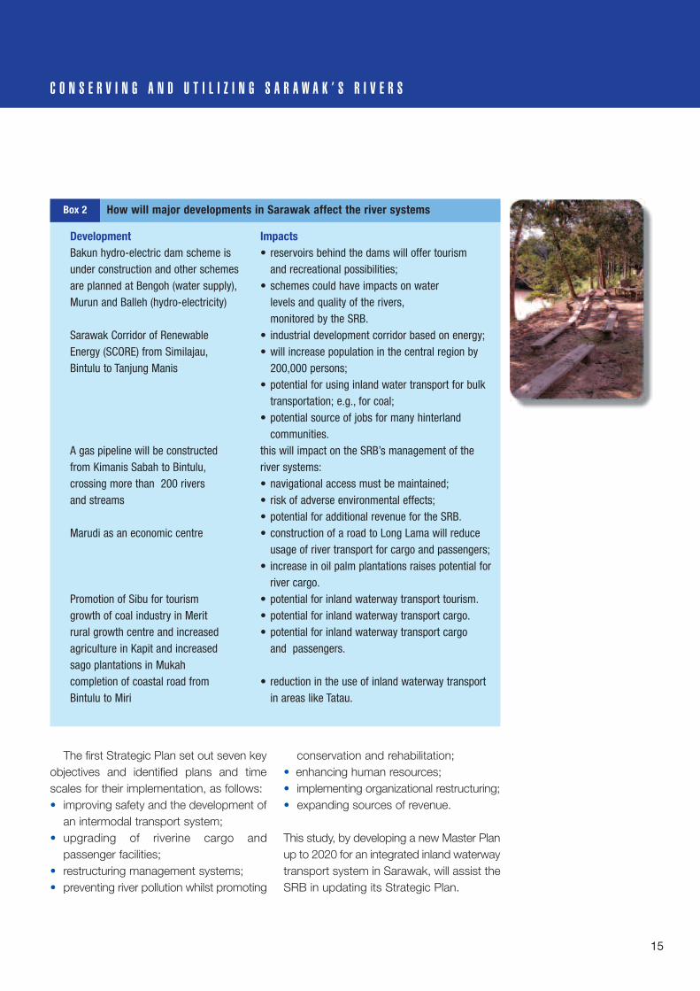
14
M A L A Y S I A I N L A N D W A T E R W A Y T R A N S P O R T S Y S T E M I N S A R A W A K
accompanied by population growth. Urbanpopulations can be expected to grow fasterthan rural populations, with internalmigration to urban areas, particularlyamong younger rural adults, in search of new opportunities. Economic andpopulation growth combined will increasedemand for domestic transport ofpassengers and cargo.
The transport modal mix on roads andwaterways is likely to continue to changebut with some modification. The extendedand improved road network is attractingpassengers to cheaper, faster, and moreconvenient low-cost bus services. Bycontrast, increasing cargo traffic on thewaterways continues its steady expansion,reflecting the cost of transporting heavy andbulky goods.
However, the difficulties of further rapidexpansion of the road system headinginland from the coast are likely to makethis trend unsustainable in the short termbecause of the nature of the steep uplandterrain, the high cost of road building forsuch a sparse population, and the highvehicle operating costs in such steepterritory. Furthermore, implementation ofimprovements proposed in the SIWTMaster Plan can be expected to increasethe efficiency of the waterways,rebalancing the modal mix somewhat infavour of inland waterway transport. Thiswould ensure the continued use of thisvaluable natural asset for the foreseeablefuture, and contribute to the alleviation ofescalating fossil fuel consumption on theroads. Other major developments areunderway or planned that could havesignificant impacts on the river system(Box 2).
T h e S a r a w a k R i v e r s B o a r dThe planning and management of the inland waterway transport system is the responsibility of the Sarawak RiversBoard (SRB). The SRB was established in October 1993 under the Sarawak Rivers Ordinance. The functions of theSRB stipulated in the Ordinance includedevelopment and improvement of theriverine transport system within the state,control and regulation of river traffic,provision and improvement of wharfs andpassenger terminals and navigationalfacilities, protection and restoration ofriverbanks, implementation of safetymeasures, and river environmentmanagement.
In the first few years of its operation, theSRB’s role was restricted to regulatingriverine traffic and providing navigationaland terminal facilities. As the Board was anew agency, plans tended to be conceivedand implemented on an ad hoc basis inresponse to immediate needs of riverinetraffic safety and cleanliness. However, by2000, it had become apparent thatstrategic planning was essential given theneed to achieve safe, clean and naturalrivers. This can be achieved throughsustainable development in the provision ofquality services to ensure optimal domestic,commercial and recreational use ofSarawak’s rivers. The development of therivers is seen as important to Sarawak’sheritage for present and future generations.
A Strategic Plan was initiated in 1999,and has provided a guiding document forthe SRB in the implementation of its shortand medium-to-long-term programmes.These cover the years 2001–2005 and2006–2016 respectively.
Whilst it is true that rivertransport will neversupplant the ubiquitouslorries and trucks in termsof speed, efficiency andflexibility, there can be nodoubt that optimizing theuse of the river system formovement of bulk andfinished products willbenefit both the transportuser and the public atlarge, financially andeconomically.
Christopher Chan,2003, p.104.
15
C O N S E R V I N G A N D U T I L I Z I N G S A R A W A K ’ S R I V E R S
The first Strategic Plan set out seven keyobjectives and identified plans and timescales for their implementation, as follows:• improving safety and the development of
an intermodal transport system;• upgrading of riverine cargo and
passenger facilities;• restructuring management systems;• preventing river pollution whilst promoting
conservation and rehabilitation;• enhancing human resources;• implementing organizational restructuring;• expanding sources of revenue.
This study, by developing a new Master Planup to 2020 for an integrated inland waterwaytransport system in Sarawak, will assist theSRB in updating its Strategic Plan.
Development ImpactsBakun hydro-electric dam scheme is • reservoirs behind the dams will offer tourism under construction and other schemes and recreational possibilities;are planned at Bengoh (water supply), • schemes could have impacts on waterMurun and Balleh (hydro-electricity) levels and quality of the rivers,
monitored by the SRB.Sarawak Corridor of Renewable • industrial development corridor based on energy;Energy (SCORE) from Similajau, • will increase population in the central region by Bintulu to Tanjung Manis 200,000 persons;
• potential for using inland water transport for bulk transportation; e.g., for coal;
• potential source of jobs for many hinterland communities.
A gas pipeline will be constructed this will impact on the SRB’s management of the from Kimanis Sabah to Bintulu, river systems:crossing more than 200 rivers • navigational access must be maintained;and streams • risk of adverse environmental effects;
• potential for additional revenue for the SRB.Marudi as an economic centre • construction of a road to Long Lama will reduce
usage of river transport for cargo and passengers;• increase in oil palm plantations raises potential for
river cargo.Promotion of Sibu for tourism • potential for inland waterway transport tourism.growth of coal industry in Merit • potential for inland waterway transport cargo.rural growth centre and increased • potential for inland waterway transport cargo agriculture in Kapit and increased and passengers.sago plantations in Mukahcompletion of coastal road from • reduction in the use of inland waterway transportBintulu to Miri in areas like Tatau.
Box 2 How will major developments in Sarawak affect the river systems
16
P O L I C Y F R A M E W O R K F O R M A L A Y S I A A N D S A R A WA K
Within the context of the long-term Vision2020 that details the emergence ofMalaysia as an industrialized nation, theshorter term national policy framework forthe Sarawak Inland Waterway Transport(SIWT) Master Plan is outlined in the Ninth Malaysia Plan 2006–2010. Whileaddressing the broader issue of
infrastructure that applies to all of thestates of Malaysia, the Ninth Plan explicitlyidentifies continuity of river transport inSarawak for the purpose of supportingsocial, economic and cultural developmentand promoting tourism (Box 3), and makesspecific reference to the Master Plan Study(Ninth Malaysia Plan, 2006–2010. p. 384).
River transport will continue to support the socio-economic and cultural development of Sarawak.
Ninth Malaysia Plan 2006-2010, p.384.
The thrust for further infrastructure development cited in the Ninth Plan is directly supportive of improved conservation and utilization of Sarawak’s inland waterways, namely by:• greater utilization of existing facilities;• increased emphasis on better service delivery and quality services;• extension of networks to underserved areas;• expansion of capacity.
Some of the strategies for infrastructure development set out in the Ninth Plan are directlyrelevant to specific Master Plan priorities for Sarawak, including:• enhancing accessibility to quality infrastructure facilities in rural areas to reduce the
urban-rural development gap: community water transport;• providing efficient and reliable services to ensure optimal utilization of infrastructure
facilities: commercial inland water transport;• improving the safety and comfort of users: safety and security;• increasing the competency and capability of service providers: institutional development
and • capacity building of SRB.
Waterborne transport is dealt with in the Infrastructure section of the Ninth Plan under theheading of ‘Ports’. This states that the use of Information and Communications Technology(ICT) will be intensified and expanded to improve port efficiency, and electronicdocumentation systems will be extended to smaller ports. The focus will continue to be onthe expansion of navigation safety systems, reducing pollution (including the disposal ofwrecks), and increasing dredging works to allow larger vessels to operate.
Box 3 Water transport and the Ninth Malaysia Plan, 2006–2010
17
P O L I C Y F R A M E W O R K F O R M A L A Y S I A A N D S A R A W A K
At the state level, a number of strategiesand plans are contributing to the promotionof economic growth and sustainabledevelopment. The following are threenotable examples.
1. The Integrated Transport InfrastructureMasterplan for Sarawak (INTIMS) aims,among a range of objectives (recommendedbut not currently adopted), to:• introduce bigger and more efficient
commercial vessels; • develop integrated public transport
terminals; • enhance the role of the SRB to be a ‘one-
stop-shop’ for internal waterwaystransport;
• privatize facilities and make the SRB apurely regulatory body;
• qualify the SRB to receive governmentgrants and generate additional fundingfrom revenues;
• ensure the SRB has the power and staffresources to act effectively.
The final report of the INTIMS was
submitted in 2006, and its proposals arescheduled to be considered as part of the mid-term review of the NinthMalaysia Plan. Meantime, these issues andrecommendations are still being discussedand debated.
2. Sarawak Rivers Ordinance created theSRB as the competent authority to managethe river systems of Sarawak. The Vision ofthe SRB is ‘Towards Safe, Clean andNatural Rivers’:• ensuring the safety of riverine traffic in
order to promote the development of anefficient inland water transport systemcontributing to the balanced developmentof Sarawak;
• ensuring the rivers remain clean and freefrom pollution by any means for domestic,commercial and recreational purposes;
• ensuring the rivers remain in their naturalstate as our common heritage, for thebenefit of present and future generations.
In its mission statement, the SRB iscommitted to achieving its Vision through

M A L A Y S I A I N L A N D W A T E R W A Y T R A N S P O R T S Y S T E M I N S A R A W A K
18
Sustainable Development and QualityServices for the Optimum domestic,commercial and recreational uses, and torealise the development of the rivers as astate heritage for present and futuregenerations. As noted above, an SRBStrategic Plan was initiated in 1999continuing into the period 2006 to 2010.
However, several other governmentagencies also have defined responsibilitiesrelating to inland water transport, and someof these overlap SRB duties. They include:Marine Department of the federal Ministry of Transport; federal and state portauthorities; Sarawak Public WorksDepartment; Sarawak Drainage andIrrigation Department; and Sarawak NaturalResources and Environment Board.
3. 2nd Sarawak Tourism Master Plan1993–2010 reflects the federal TourismStrategic Plan and the Ninth Malaysia Planwith emphasis on:• ensuring sustainable tourism develop-
ment;• developing innovative tourism products
and services;• encouraging domestic tourism;• ensuring comfort and safety of tourists.The Tourism Master Plan provides the guiding framework for Sarawak’stourism development, defining sustainablemanagement strategies. The main themesof the Plan are product development,marketing management, marketingoperations, access and contribution tosocio-economic development. The productdevelopment strategies focus on nature,adventure, and cultural tourism products.
19
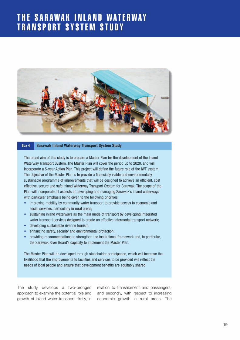
T H E S A R A W A K I N L A N D W A T E R WA YT R A N S P O R T S Y S T E M S T U D Y
The study develops a two-prongedapproach to examine the potential role andgrowth of inland water transport: firstly, in
relation to transhipment and passengers;and secondly, with respect to increasingeconomic growth in rural areas. The
The broad aim of this study is to prepare a Master Plan for the development of the InlandWaterway Transport System. The Master Plan will cover the period up to 2020, and willincorporate a 5-year Action Plan. This project will define the future role of the IWT system.The objective of the Master Plan is to provide a financially viable and environmentallysustainable programme of improvements that will be designed to achieve an efficient, costeffective, secure and safe Inland Waterway Transport System for Sarawak. The scope of thePlan will incorporate all aspects of developing and managing Sarawak’s inland waterwayswith particular emphasis being given to the following priorities:• improving mobility by community water transport to provide access to economic and
social services, particularly in rural areas;• sustaining inland waterways as the main mode of transport by developing integrated
water transport services designed to create an effective intermodal transport network;• developing sustainable riverine tourism;• enhancing safety, security and environmental protection;• providing recommendations to strengthen the institutional framework and, in particular,
the Sarawak River Board’s capacity to implement the Master Plan.
The Master Plan will be developed through stakeholder participation, which will increase thelikelihood that the improvements to facilities and services to be provided will reflect theneeds of local people and ensure that development benefits are equitably shared.
Box 4 Sarawak Inland Waterway Transport System Study
development of a competitive strategy forSIWT includes moves to:• establish economic and environmental
benefits of inland water transport asopposed to other modes of transport;
• strengthen the market position of existingcargo and passenger services;
• increase market share by establishing aniche market for Sarawak’s inland watertransport;
• ensure interventions incorporatemeasures that address security andsafety concerns;
• define targets in terms of modal share,job creation, and potential revenuegeneration from inland water transport;
• participate in education programmes andknowledge exchange with other inlandwaterway transport authorities in Asia asa base for long-term harmonisation ofinland waterway transport in the region.
The SIWT project is being completed overa period of two years, September 2006 toAugust 2008. The first year was devoted tocompleting the necessary preliminary work,writing the project document, makingorganizational arrangements, gainingapprovals, and recruiting staff.
The study itself is being carried out in thesecond year and adopts the broad conceptof CONNECTivity, encapsulating the keyfeatures of the Master Plan-studyapproach.
This concept highlights the study’sintention of examining all aspects oftransport in Sarawak’s river-systeminfrastructure: commercial cargo andpassenger services, transport at thecommunity level, and transport for tourism.The study is addressing issues relating tosafety and the capacity of the Sarawak
Rivers Board to manage inland watertransport. The study emphasizes that theMaster Plan must be economically,financially, environmentally and sociallysustainable.
Most importantly, the concept definesthe approach of preparing the Master Planin partnership with organisations andcommunities with interests in this sector.This is crucial to achieving sustainability. Ifthe Master Plan is to be implementedsuccessfully, it must be realistic, practical,and address the needs and priorities of thestakeholders by whom, ultimately, it mustbe owned. A participatory approach to thepreparation of the Master Plan involving allstakeholders—public and private, civilsociety, boat owners/operators and
20
M A L A Y S I A I N L A N D W A T E R W A Y T R A N S P O R T S Y S T E M I N S A R A W A K
• ensure international performance standards in the development ofefficient inland waterway transport are applied to Sarawak’s riversystems to exploit the comparative economic advantages of commercialriver transportation as one component of an integrated state transportnetwork;
• promote development of viable community water transport, takingaccount of the characteristics of rural Sarawak, to increase the mobilityand access of communities (cheaper, faster, more reliable and safertransport) and promote poverty reduction;
• promote high standard, sustainable riverine tourism, competitive in theinternational market and benefiting rural communities;
• adopt international best practices and standards for navigation, wharfand terminal safety and security adapted to Sarawak’s river systems,and protective of the river environment and heritage
• identify core functions of the Sarawak Rivers Board as the competentauthority for river transportation clearly defined, properly resourced andefficiently implemented.
G o a l s f o r t h e p r e p a r a t i o n a n d i m p l e m e n t a t i o n o f t h e M a s t e r P l a n
Defining CONNECTivity~ Community and -~ Organization partnership~ Networked river
infrastructure for safenavigation
~ Nature and sustainability~ Equity for all stakeholders~ Capacity building for SRB~ Transportation and
tourism

21
T H E S A R A W A K I N L A N D W A T E R W A Y T R A N S P O R T S Y S T E M S T U D Y
users—is intended to maximise thelikelihood that the proposed improvementsreflect real needs and ensure thatdevelopment benefits are equitably shared.
T h e s t u d y m e t h o d o l o g yThe study was divided into 3 stages to beimplemented over the course of 52 weeks.The schedule has been subject to someunavoidable delays but the study isproceeding satisfactorily.
Stage One: Goal setting (6 weeks).In Stage One, the task of a speciallyorganised SRB team working with a smallgroup of international consultants was todevelop goals and competitive strategy;define issues and key geographical areasfor study; develop the concept plan and, bymeans of a workshop, outline the detailedterms of reference for Stage 2. Thedeliverable for Stage One was the ConceptMaster Plan (Inception Report). This willform an integral part of the completedMaster Plan.
Stage Two: Detailed study of the issues (20 weeks).Stage Two involves the planning team, withthe subsequent support of internationalconsultants, overseeing a cluster of miniconsultancies, mainly by local consultantswho are optimizing stakeholder involvementin each component. The consultants areundertaking and submitting the analysis,demand, operational and layer plans and guidelines developed through groundsurveys, focus groups, and workshops.This stage includes the utilization of a localteam overseeing the mini consultancies
with international consultants; the miniconsultancies allow for better stake-holder control over each component. Thedeliverable for Stage Two is the DetailedComponents (Interim Report). This will alsoform an integral part of the completedMaster Plan.
Stage Three: Synthesis and production (22 weeks).In Stage Three, the findings from the miniconsultancies will be utilized to formulatethe final SRB Master Plan and 5-yearAction Plan. These will be developed by theplanning team consisting of the local SRBteam and the international consultants. The development and phasing strategy,implementation and capacity strategies willalso be determined during this stage. Thedeliverables for Stage Three are the DraftFinal Master Plan Report and the FinalMaster Plan Report.

22
S C O P E O F T H E S A R A W A K I N L A N D W A T E R WA YT R A N S P O R T M A S T E R P L A N
O b j e c t i v eAs previously noted (Box 4), the objective ofthe Sarawak Inland Waterway Transport(SIWT) Master Plan is to provide a financiallyviable and environmentally sustainableprogramme of improvements designed toachieve an efficient, cost-effective secureand safe inland waterway transport systemserving the needs of Sarawak.
An efficient and cost-effective inlandwaterway transport system, integrated withother modes into an intermodal nationaltransport network, will serve the needs
of Sarawak in two ways: • it will contribute economic growth by
increasing the overall efficiency of thetransport sector, supporting the NinthMalaysia Plan thrust of developinginfrastructure services to facilitate growthin other sectors;
• it will impact directly and indirectly onpoverty reduction by reducing ruralisolation and improving access, especiallyby disadvantaged groups, to health andeducation services, and to income-earning opportunities.

23
Items 1.-3. comprise the three main elements of riverine transport; the
other items deal with their operation and management.
1. commercial cargo and passenger inland water transport, and
intermodal transport;
2. community water transport;
3. sustainable riverine tourism;
4. the priorities of safety and security;
5. the cross-cutting environmental sustainability and enhancement;
6. the cross-cutting institutional strengthening and capacity building;
7. all-embracing priorities of sustainable development, public
participation, communication strategy, and knowledge management.
K e y c o m p o n e n t s o f t h e S I W T M a s t e r P l a n
S C O P E O F T H E S A R A W A K I N L A N D W A T E R W A Y T R A N S P O R T M A S T E R P L A N
T i m e h o r i z o nThe Master Plan has three time horizons:• a long-term Master Plan running from
2008 to 2020;• a five-year Action Plan beginning in 2008;• Pilot Projects to initiate implementation of
the Master Plan beginning in 2008(subject to approval of funding).
S t a g e O n eThe Master Plan addresses currentconstraints for realizing the potential forutilizing the valuable natural resource ofnavigable river systems efficiently, andidentifies sustainable improvements. ThePlan aims to exploit the potential to increase modal share of cargo carried byinland water transport; consolidate inlandwaterway passenger services; and provideefficient community water transport,complementing improved rural roads toincrease the mobility and access of ruralcommunities. The Stage One ConceptMaster Plan (Inception Report) sets out theproposed goals, future directions andcompetitive strategies for the developmentof inland waterway transport.
Stage Two, the detailed study of theissues, is currently proceeding, and StageThree will see the culmination of the study in the synthesis and production of theMaster Plan itself.
Sust
aina
ble
Dev
elop
men
t
Communication Strategy & Knowledge Management
Publ
icPa
rtic
ipat
ion
Safety and Security
Environment
Institutional Strengthening& Capacity Building
Com
mun
ityW
ater
Tran
spor
t
Com
mer
cial
Inla
ndW
ater
Tran
spor
t
Sust
aina
ble
Rive
rTou
rism
Figure 1 Connectedness of the key components of the SIWT Master Plan

24
D E L I N E A T I N G T H E S T U D Y A R E A S
S e l e c t i o n o f s t u d y a r e a sThe limited time scale and resourcesavailable for the Master Plan Study meanthat detailed field investigation covering allnavigable river systems of Sarawak is notfeasible. Consequently, available secondarydata for the whole of Sarawak’s river systemwas assembled and analyzed, but detailedfieldwork focused on three regions selectedas important and representative. Theselocations were selected to represent thediffering conditions of:• sustainable commercial inland water
transport of cargo and passengers;
• community water transport;• sustainable riverine tourism.The study areas, selected throughworkshop discussion, cover the upland,middle and lower altitude terrain conditionsof the river systems in Sarawak as well asthe low-lying Rajang delta area (Map 3).They also encompass areas with differentpotential for economic development,including existing and future growth areasfor industry, agriculture and tourism.
Conceptually, the regions selectedidentify the potential for an interconnectedinland waterway corridor or network across
LABUAN
TELUK BRUNEI(BRUNEI BAY)
Batu Timbul PelongTg PelongP. Muara BK.
Lawas Btg
Bt.Suang
L.Semado
Ulu Trusan
Hulu
S. Madirit G. Murud
BaKalalan
Ruan Tong
S.Dap
urS.
Kela
pang
LAWASLawas
DU
AT
Trusan
Batang
Merapok
L.Sukang
Btg. Limbang
Bt.Ladan
Bt.BatuLawi
Bt. Teraja
Bakung
Tinj
or
Batan
g
S. Baku
ng Bar
om
L. Linel
Tg. Baram
LutongTg. Lobong
TELUK LOAK
Sibuti
L.Miri
Bt. Abandong
S. Dopa
Bt. Batu Song
Pa Tik
Bareo
Bt. Selalap
L. SenialL. Lalang
G. Malapa
Lio Matoh
L. Wat
S. Palutan
SilotS.
HuluBoram
S.Aka
h
Niah
S. Sibuti
K. SUAISuai
Btg
Suai
S. Niah
BekanuK. Nyabor
S.Pa
tah
Bt. Nakan
L. Terbangan
Bt. Simang
L.Palai
DATARAN TINGGI USUN
L.Toan G. Panjang
BANJARAN
TAMA
ABU
L. Akah
Bt. Kalulong
Apo Upa
Bt. Lawan
BELAGABt.
Segaham
Bt.Punan
Bt. Ajau
L. Murum
L. Gang
Bt. Bora
Bt. Kayo
Bedian
BAHAGIAN KAPIT
Bt. DamaDATARAN TINGGI
BATU LAGA
G.Kajang
Bt. TasuG. BaningBt. Bakak
SONGKANOWIT
BAHAGIAN SIBU
SARIKEI
DARO
MATU
DALAT
Balingian
MUKAHTATAU
K A L I M A N T A N(INDONESIA)
SOUTH CHINA SEA
K.Tatau
Lemai
BAHAGIAN BINTULU
Meluah
BAHAGIAN
Rajang
SalalangMERADONG
Pakan
SRI AMANLingga
Bt. Batu
SARIKEI
LUBOK ANTU
Bt. Entimau
BETONG
SAMARAHAN
SIMUNJAN
BAHAGIAN KUCHING
LUNDU
Sematang
Bako
KUCHING
KOTASAMABAHAN
BAHAGIAN
Asajaya
Mongkos
TebeduTebakang
Balai Ringin
Tg. Serabang
Tg. Datuk
P. SompadiP. Satang
P. Lakei S. Nga
mah
Poi Batang
S.Po
i
Batang Oya
Kabong
Tg. JerijehDurin
Tg. Sirik IganBatang
ya
Btg. Matu
Btg
Lass
a
Tg. Kidurong
Batang
Btg. Mukah
Btg.
S. Anap
S. Posar
Igan
PulauB
ruit
Batang. Mukah
S.Gigis
S. Tamin
Tatau
Bal
ingi
an
Tg. Simlajau
S. Penyuan
S. Maliah
S. Murum
S. Seping
Pajang
Batang Bakui
Batang
S.Ba
S. Kakus
S.Se
bauh
K. BINTULU Sebiu
BatangSebauh
Pandan
Labang
Tubau
Bt. Sekiwa
M. L
ASSA
Tg. PoP. Burung
Robang
S. Kerian
Spaoh
Pusa DobakS. Rimbang
Tg. Melaban
S. Maludam
K. SARBAS
K. RAJANG
K. PALOH
K. IGAN
K. MUKAH
K. TATAU
S. Sera
S. Likau
S. Simlajau
Kemena
S. Jelalang
S. Kay
an
Beloga
Batang
S. Pandan
S.Tubau
S.Bi
no
K.SADONG
Tg. BatuG. PutingG. Puah
G. Berumput
G. Kandai
Bt. Besi
Btg.
Kaya
n
Bt. Gumbang
Bt. Penrisson Padawan
Bt. Meranja Kecil
Bt. RawanBt. Niat
Bt.Balau Hulu
S.Julau
Bt. Besai
Batang
Btg. S
eker
ang
Btg. L
ayar
S.En
gkar
i
Engkari Bt. Biru
Bt. Makup
Bt. Condong
Tintang Kedang
G. Libu
Batang
G. Loi
G. CemaruBt. Batu Tiban
G. Makital
G. Batubulan
S. Bilang
S. Batang Balui
S. Seran
Lebu
wai
S. KajangS. Linau
S. Malarang
S. Linau
S. Kaluan S. Danum
S. PieranS. Ti
yut
S. Bahau
BolehBt. Tunggal
RajangS. Katibas
S. Katibas
S. Mengiong
S. Majau
S. MujangS.Pila
S. Entuloh
S.M
elat
ai
S. Gaat
BatangBoleh S. Putai
S. GoatS. BalangS. Bangkit
S.En
tulu
G. Meraci
Btg.
Sada
ng
P. Talang-Talang
Bt. Grogo
Bt. Sengkajau
Bt.Raya
Bt.Sidi
KAPIT
Bt. KumbongG.
NIE
UW
ENHU
IS
Bt. Jimbong
L.Jawi
BANJARANDULIT
Sungai
Bat
ang
Beluru
S. Kargo
MIRI
MARUDI
BAHAGIAN MIRI
S. Miri
K. Baram
K. Baram
G. Buda
G. Mulu
Bt.Batu
Patam
L.S. Buang
S. Kubaan
S. MagohBt.
TemalaApoh
S. Medalam
Bt.Ratak
LIMBANG
BRUNEI
BRUNEI
BAHAGIAN LIMBNG
SABAH
BANJARA
NM
ALIG
AN
Limbang
Btg. Matu
M. Sereaeag
S. Simunjan
Kanan
Btg. Kerang
Btg. SaribasBatang Lupar
Btg. Seterap
BANJARAN KELINGKANG
Btg. Sadang
S. Kanowit
S.Ka
hoi
PEGUNUNGAN IRAN
BAN
JARA
NAP
O
REFERENCESempadan Antarabangsa..................International BoundarySempadan Negeri................................State BoundarySempadan Bahagian...........................Divisional BoundaryJalan Raya Utama................................Trunk RoadJalan Raya Kedua................................Secondary RoadJalan Raya Sedang Dibina.................Road Under ConstructionIbu Bahagian........................................Divisional HeadquartersIbu Daerah............................................District HeadquartersPekan.....................................................BazaarKampung................................................VillagePadang Terbang, Lapangan TerbangAirport, AirfieldRumahapi...............................................Lighthouse
– + – ——– + – ——
—— – – – ———— – – – ——
—— – – – ———— – – – ——Kilometre
0 30 120 150
Scale 1 : 2,000,000
Mile0 20 30 40 50 ?010 70 80 90 100
A R E A 1Rajang Delta, MidRajang & Kemena
A R E A 2Miri, Mulu &
Limbang
A R E A 3Kuching & Betong
BINTANGOR
SIBU
BAHAGIAN SRI AMAN
SARATOK
Batu Kawa
BAU
Pantu
Santubong
SERIAN
JULAU
BINTULU
L. AtipL.Lama
Tutuh
L.Seridan
S. Seblak
PEGUNUNGANHOSE
Map 3 Study areas comprising the inland waterway transport corridor
25
S C O P E O F T H E S A R A W A K I N L A N D W A T E R W A Y T R A N S P O R T M A S T E R P L A N
three geographical areas:• Kuching-Betong;• Rajang-Kemena-Bintulu;• Miri-Mulu-Limbang.In respect of commercial inland waterwaytransport, the study areas:• include the major navigable river systems
and major routes where passengerexpress and speedboat services operate;
• cover all the rivers linked to major ports andthe major access points by road and air tothe inland waterway transport system;
• provide specific opportunities to studythe potential for –~ movement by inland waterway of
construction materials and commo-dities sourced from rural areas;
~ extension of inland waterway trans-port to coastal operations.
The study areas cover the high poverty rurallocations where communities rely on rivertransport using longboats, and a range ofvarying rural demographic and socio-economic conditions.
With regard to riverine tourism, the studyareas selected include locations:• to study the potential for developing a
variety of types of sustainable recreationand leisure products;
• to enhance tourism that is alreadyestablished, revitalize tourism that hasdeclined and, where there is potential,promote the concept of riverine tourism.
K e y s t u d y r e g i o n sThe selected study areas are characterisedby several important components:• the river corridor comprising main
navigable rivers that link gateway cities todevelopment and growth areas where
integrated planning can be carried out in detail;
• gateway cities constituting primaryaccess points to the inland waterwaytransport network for cargo and passengertraffic via major ports, terminals, airportsand roads; the potential of major facilitiesfor transhipment, passenger connectivityand intermodal transport is a potentialconsideration;
• existing or growth areas for agriculture,industry, or tourism that could contributeto the development of inland waterwaytransport;
• community centres comprising popu-lation centres that rely on the river corridorfor transportation, where improvement ofinland waterway transport facilities will beaddressed;
• areas of poverty comprising ruralcommunities reliant on inland watertransport that will be studied in an attemptto increase economic activity and improveinland waterway transport facilities.
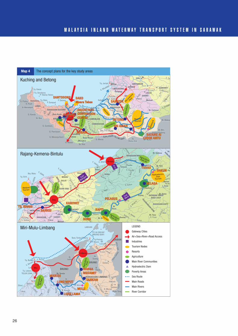
26
M A L A Y S I A I N L A N D W A T E R W A Y T R A N S P O R T S Y S T E M I N S A R A W A K
KANOWITTW
SARIKEISA
hMeluahhM
BAHAGIANN
SalalanSalalangSalalanlalangMERADONGO
Pakan
aLinggaaLL
Bt. Batu
SARIKEIIISA
aimauBt. Entimaumau
SAMARAHANAMARS NS NANA
SAMUNJANS N N
BAHAGIAN KUCHINGB HAGIAN KUCA K HCHIN
LUNDUNDUU
Sematangg
ANMABAHMABAHANSAMABAHMSSS MABAHA
BAHAGIANGHAGIB
Asajayaasajaya
ggMongkosgM
TebedubTebakangkebakangkTeTebakange
Balai Ringinlai RinRin
Tg. Serabang
Tg. Datuk
P. SompadiP. Satang
P. Lakei S. Nga
mah
N. Ng
Poi Batangi B
S.Po
iS
Po
Kabong
Tg. JerijehDurin
S. Tam
Tg. PoP. Burung
RobangR ng
S. KerianK
hpSpaohp h
aPusaa DebakDebaS. Rimbang
RTg. Melabana
S. Maludam
K. SARBASSK. SARBAS
K. RAJANG
K.SADONG
Tg. BatuG. PutingG. Puah
G. Berumput
G. Kandai
Bt. Besi
Btg.
Kaya
nKKa
yayKa
G. Gumbang
G. Penrisson nnaanPadawanwanan
G. Meranja Kecil
G. RawanBt. NiatBB
Bt.Balau Hulu
S.JulauJul u
Bt. Besai
Batang
BBtg
. Sek
eran
g
Btg. L
BBBLa
yar
BL
r
S.En
gkar
iEn
EngkiliE Bt. Biru
Bt. Makup
Tintang Kedang
SS. Katibasba bS. at ba
G. Meraci
Btg.
tgtgBSa
dang
daSa
P. Talang-Talang
ereeaaaeeeaggggg
S. Simunjan
Kannan
BBtB g. KeK rang
BBBtttg. SaribasBatang Lupppaarr
Btggg. Seterapp
BANJARAN KELINGKAK NANA G
BBBtttggg.. Sadanngg
SSS.. KKKKKanowiitt
ANGOANGORBINTANGOB NGOOANGO
SIBU
BBAHAGIAN SRI AMANB RBAHAGIAN SRI AMAN
Batu Kawat wwa
BAU
PantuP
LAUJULAUUL
S. Seblakbl
LABUAN
TELUK BRUNEI(BRUNEI BAY)
Batu Timbul PelongTg Pelong
P. Muara BK.Lawasassas Btg
Bt
Bt.Suang
L.Semadom
Uluu nTrusann
Hulu
S. Madirit
Mirit G. Murud
BaBKalalanK
Ruan TongRRuR
LAWASLAAWASLALawasas
DU
AT
Trusan
Batangng
MerapokkMMM oM
L.Sukang
Btg. Limbang
gLim
gLim
bam
bL
g
Bt.Ladan
Bt.Bt.Batu
wiLawiLawiLawiLLawi
Bt. Teraja
Bakungaku
Tinj
orn
akakung
kkngng B
arom
L. LinelL
Tg. Baram
LutongTg. Lobong
TELUK LOAK
Sibuti
L. WatL at
Niah
S. Sibuti
S.u
BekanuBekanuK. NyaborrK.
SungaiBeluruelurBB
S. Kargoo
S. Miri
K. Baram
K. Baram
G. BudaBB
G. MuluG
Bt.Batu
Patam
L.LS. BuangSS g S. Magoh
gBt.TemalaTTTT
ApohAApohog
ApohApoh
S.Medalamam
Bt.RatakkkBRUNEI
BRUNEI
BAHAGIAN LIMBNGAHA
SABAH
BANJARA
NM
ALIG
AN
LimbbangTutuh
L.LL.Seridann
ii
Bt. NB
Bt.Segahamme
BPuna
Bt. Ajaut Ajau
L. MurumL.
L. Gang
BAHAGIAN KAPITG
Bt. DamaDATARAN TINGGI
BATU LAGATU LAG
G.Kajang
PEGUNUNGANHOSE
EGN
HOSE
Bt. TasuG. BaningBt. Bakak
SONGKANOWITTW
BAHAGIAN SIBUSIBU
SARIKEISARIKEI
DARO
MATUUMA
DALATT
Balingian
MUKAHTATAUU
K.TatauT
Lemai
BAHAGIAN BINTULUBB A B L
hMeluahhM
BAHAGIANN
SalalangSalalangSalalanglalangMERADONGONG
Pakan
S.SNNga
mah
N. Ng
Poi Batangi B
S.Po
iS
Po
gg
erijehDurin
Tg. Sirik gIganggg
tanatang
Batangatan
Btg. Matu
Btg
Lass
a
Tg. Kidurong
Batang
Btg. Mukah
Btg.g
S. AnapAn p
S. Posarsa
So
Igan
PulauB
ruit
Batang. Mukahukahah
BBBgS.Gigis
SSSSs
S. Tamin
Tatau
Bal
ingi
ani S. Penyuanyuan
S. Maliah
liah
S. MuSS Mu
S. SepingS S pi
L M
S
Pajang
Pj
g
P
Batang Bakui
Batang Bakui
Batangg
S.Ba
S. Kakus
S.Se
bauh
Suh
S
K. BINTULU SebiuSSS bi
BatangB angSebauhh
Pandan
Labang
kBt. Sekikiwak
M. L
ASSA
RobangR ng
AJANG
K. PALOHHH
K. IGAN
K. MUKAHHH
K. TATAU
S. Sera
S. Likauuu
Simlajau
S
Kemena
S. Jelalang
S
n
S. Kay
an
Beloga
B
Batang
S. Pandandan
S.Tubau
S.Bi
no
S.JulauJul u Le
buw
aiL
w
S
S
Rajangang
s
S. Katibas
KKa
S. Majauajau
S. Mujang
MujS.Pila
atat
BatanggBolehB
S. PutaiS
Bt.Rayaa
KAPITKAPITL.
Jawiiw
BANJARA
ANJA
BBtg. Matu
MM. Sereeaaaeeeaggggg
SSS.. KKKKKanowiitt
ANANGORBINTANBIN NGOROAN
SIBU
LAUJULAUUL
S. Seblakbl
Kuching and Betong
Rajang-Kemena-Bintulu
Miri-Mulu-Limbang
AgricultureRecreatio
nal
Park
Tourism
RiverineTourism
WetlandTourism
Coal
Balingan
Coal
Merit
HydroelectricDam
Tourism
Maludam
Bata
ngAi
Agric
ultu
reTownCentre
Agric
ultu
re
Agric
ultu
reOi
l Pal
m
Agric
ultu
reFr
uit
SANTOBONGSANTOBONG
SERIANSERIAN
LUBOK ANTULUBOK ANTUBATANG AIBATANG AI
SRI AMANSRI AMAN
BETONGBETONG
SARATOKSARATOK
KUCHINGKUCHING
BAKOBAKOMuara TebasMuara Tebas
INDUSTRIESINDUSTRIESCONVENTIONCONVENTIONCENTRECENTRE
Agric
ultu
reSa
go
AgriculturePalm Oil
AgriculturePalm Oil
Miri
Limbang
MARUDIMARUDI
LONG KIPUTLONG KIPUTTARIKANTARIKAN
NANGA MEDAMITMEDAMIT
Sibu
Bintulu
TG. MANISTG. MANISSARIKEISARIKEI
KANOWITKANOWIT
SONGSONG
PELAGUSPELAGUS
BELAGABELAGA
TUBAUTUBAUBAKUNBAKUN
KAPITKAPIT
LONG LAMALONG LAMA
MULUMULU
Tourism
NG
LEGEND
Gateway Cities
Air+Sea+River+Road Access
Industries
Tourism Nodes
Resorts
Agriculture
Main River Communities
Hydroelectric Dam
Poverty Areas
Sea Route
Main Roads
Main Rivers
River Corridor
Map 4 The concept plans for the key study areas
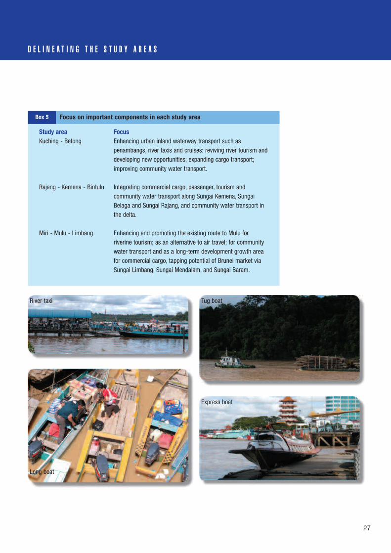
27
D E L I N E A T I N G T H E S T U D Y A R E A S
Study area FocusKuching - Betong Enhancing urban inland waterway transport such as
penambangs, river taxis and cruises; reviving river tourism anddeveloping new opportunities; expanding cargo transport;improving community water transport.
Rajang - Kemena - Bintulu Integrating commercial cargo, passenger, tourism andcommunity water transport along Sungai Kemena, SungaiBelaga and Sungai Rajang, and community water transport inthe delta.
Miri - Mulu - Limbang Enhancing and promoting the existing route to Mulu forriverine tourism; as an alternative to air travel; for communitywater transport and as a long-term development growth areafor commercial cargo, tapping potential of Brunei market viaSungai Limbang, Sungai Mendalam, and Sungai Baram.
Box 5 Focus on important components in each study area
River taxi
Long boat
Tug boat
Express boat

A D D R E S S I N G S T R A T E G I E S A N D I S S U E S
28
E n h a n c i n g C o m m e r c i a lI n l a n d W a t e r w a y a n dI n t e r m o d a l T r a n s p o r tThe future direction is to transformcommercial inland waterway transport inSarawak into a modern, efficient and safe system, exploiting its comparativeeconomic and environmental advantagesas a key component of an integrated state-wide transport system. The strategy will beto define a programme to improve thewaterway and landside infrastructure forcommercial inland waterway transport andits management to international standards;and to facilitate the operation of modern,efficient vessels and the provision ofcompetitive and demand-responsiveservices by the private sector.
The critical issues for the commercialinland waterway transport sub-sector allrelate to its transformation into a modern,efficient and safe transport system whichwill realize its potential economic andenvironmental advantages over roadtransport. Exploiting these potentialadvantages by developing efficientcommercial inland waterway transport, aspart of an integrated state transport systemwith the necessary intermodal linkages, will be an effective use of investmentresources and reduce the total costs of the transport sector.
To be successful, the transformation ofcommercial inland waterway transport intoa modern and safe system necessitates:• accepting that efficient inland waterway
transport has lower operating costs thanroad transport for movement of longdistance cargo;
• defining future regional and domesticscope and components of inland
water transport;• establishing the potential future demand
for inland waterway transport traffic cargoand passenger services;
• identifying the measures required to reachinland waterway transport’s full potential.
An assessment has been made of themeasures required to realise the potentialfuture demand for inland waterwaytransport cargo and passenger services.These include the following:
Waterway infrastructure. Dredging todeepen channels, and the installation ofnavigation lights would permit betteraccess for cruise vessels, and theoperation of larger cargo vessels withlower unit costs; these steps would
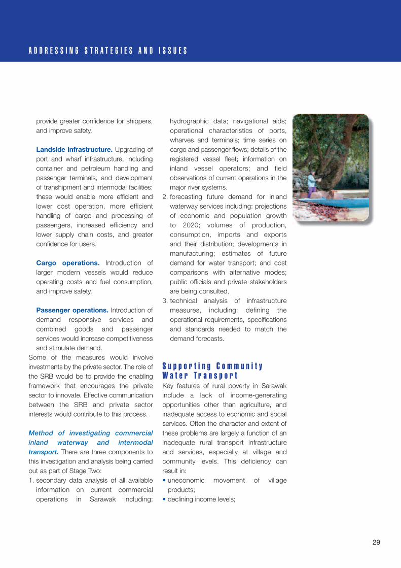
provide greater confidence for shippers,and improve safety.
Landside infrastructure. Upgrading ofport and wharf infrastructure, includingcontainer and petroleum handling andpassenger terminals, and developmentof transhipment and intermodal facilities;these would enable more efficient andlower cost operation, more efficienthandling of cargo and processing ofpassengers, increased efficiency andlower supply chain costs, and greaterconfidence for users.
Cargo operations. Introduction oflarger modern vessels would reduceoperating costs and fuel consumption,and improve safety.
Passenger operations. Introduction ofdemand responsive services andcombined goods and passengerservices would increase competitivenessand stimulate demand.
Some of the measures would involveinvestments by the private sector. The role ofthe SRB would be to provide the enablingframework that encourages the privatesector to innovate. Effective communicationbetween the SRB and private sectorinterests would contribute to this process.
Method of investigating commercialinland waterway and intermodaltransport. There are three components tothis investigation and analysis being carriedout as part of Stage Two: 1. secondary data analysis of all available
information on current commercialoperations in Sarawak including:
hydrographic data; navigational aids;operational characteristics of ports,wharves and terminals; time series oncargo and passenger flows; details of theregistered vessel fleet; information oninland vessel operators; and fieldobservations of current operations in themajor river systems.
2. forecasting future demand for inlandwaterway services including: projectionsof economic and population growth to 2020; volumes of production,consumption, imports and exports and their distribution; developments inmanufacturing; estimates of futuredemand for water transport; and costcomparisons with alternative modes;public officials and private stakeholdersare being consulted.
3. technical analysis of infrastructuremeasures, including: defining theoperational requirements, specificationsand standards needed to match thedemand forecasts.
S u p p o r t i n g C o m m u n i t yW a t e r T r a n s p o r tKey features of rural poverty in Sarawakinclude a lack of income-generatingopportunities other than agriculture, andinadequate access to economic and socialservices. Often the character and extent ofthese problems are largely a function of aninadequate rural transport infrastructureand services, especially at village andcommunity levels. This deficiency can result in:• uneconomic movement of village
products;• declining income levels;
A D D R E S S I N G S T R A T E G I E S A N D I S S U E S
29

30
M A L A Y S I A I N L A N D W A T E R W A Y T R A N S P O R T S Y S T E M I N S A R A W A K
• increased cost of imported basic goodsand provisions;
• restricted access to public services,resulting in declining health, nutrition andeducation status;
• marginalization of households andpopulation subgroups;
• isolation from knowledge/networks anddiminished social capital.
Ease of access to transport services, riveror otherwise, has a significant and positiveimpact on social and economic indicatorsof ‘wellbeing’ and on the overall quality oflife in rural communities. The availability,affordability and reliability of communitywater transportation directly affect accessto markets as well as to primary healthservices and education. Furthermore, thelack of community water transport (CWT)services negatively affects the ability of localgovernment to supply public services andcivil organisations to operate in rural areas.
Community water transport has twomajor considerations that requireaddressing: operational costs, and qualityof infrastructure. The most critical issuefacing the community water transport sub-sector is the high and increasing cost ofoperation of motorized longboats, dueprimarily to rising fuel prices. Twoapproaches are possible in addressing thisissue; regulation/subsidy of fuel process,and technical innovation.
Regulation/subsidy of fuel prices. Fuelprices are regulated in the urban centres ofSarawak, but there is a fairly steep rise inthe price gradient for fuel distributed tomore remote areas. The consequence isthat the poor, disadvantaged groups, whoare dependent on their longboats, pay a
significantly higher price for fuel than higher-income urban dwellers.
The study is reviewing the possibleresponses, which include a single, pan-territory price regulation of fuel; priceregulation at different levels to take accountof actual distribution costs; and targetedfuel subsidies for rural boat users (for whichfisheries have already set a precedent). Thisis a complex and controversial issue, andfurther economic analysis is required inorder to provide a basis for informed policyrecommendations.
Technical innovations to reduceoperating costs. International experienceindicates that it is worthwhile exploring thepotential for reducing operating coststhrough technical innovation. Mostlongboats in Sarawak are powered byoutboard petrol engines. This contrasts withthe practice in most parts of Southeast Asiawhere diesel engines predominate,mounted either inboard or as ‘long-tail
• at the time of the 2000 census, about 600,000 people, or about one-quarter of the total population of Sarawak, depended on rivertransportation;
• a higher than average fertility rate among rural communities will haveincreased this number significantly (although this will have been partlyoffset by some outward migration among young people); this trend canbe expected to continue;
• river-dependent people are predominantly rural and lower income;• the Orang Ulu and Iban people are the most dependent on river
transportation;• other groups especially reliant on the river include Melanau, Malays and
Chinese.
C o m m u n i t y W a t e r T r a n s p o r t

31
A D D R E S S I N G S T R A T E G I E S A N D I S S U E S
motors’ pivoted on the stern of the boat.Outboard petrol engines are relativelycostly, not very durable, and have higherfuel consumption costs.
Other possible innovations include:improved design of transmission systemsincorporating a reduction gearbox betweenengine and propeller; a more efficientsystem of protecting the propeller withguards and a mechanism analogous to thatof the long-tail motors that facilitate raisingthe propeller in very low-water conditions;and improvement in hull designs formotorised boats based on traditional styles.
There are several problems to beaddressed in considering improvements tocommunity water transport infrastructure,including the efficiency of actual movementof transport along the rivers themselves.
Navigation in shallow water. Stretchesof shallow water during periods of low flowcan be hazardous, particularly upstream.Spot dredging, marking and maintenanceof navigation channels, and prevention ofriverbank erosion, offer the most practicalsolutions.
Hazards presented by rapids.Negotiating rapids, especially at times oflow-water levels, can be tricky andhazardous. Where rapids are of noparticular environmental or tourist value,alternative by-pass channels may befeasible in some instances, and navigationroutes can be established and marked.
Inadequate jetties and landings. Manylandings are unsafe, inefficient and difficultto use. At the community level, availability ofstandard designs for construction and
operation to suit varying conditions, withsafety equipment and awareness trainingfor frequent users, would be a fundamentalimprovement. In addition, technical andfinancial assistance, together with supplykits of standard components, and lighting,could achieve substantial improvements.
An integrated planning approach.Construction of other facilities such asroads and bridges crossing navigablerivers, and other elements of the physicalinfrastructure, need to take account of boat movements and access. Atappropriate localities, passenger and cargolanding facilities designed as part of bridgeswould be highly advantageous.
Method of investigating communitywater transport. There are four componentsto the community water transportinvestigation and analysis being carriedout during Stage Two including:1. secondary data analysis of the extent of
community water transport operationson the various river systems, and theirrelationship to low-income levels, socio-economic disadvantage and poverty; theintention is to map these operations andhow they relate to poverty, and to

M A L A Y S I A I N L A N D W A T E R W A Y T R A N S P O R T S Y S T E M I N S A R A W A K
32
develop a secondary database oncommunity water transport.
2. primary case studies to be carried out inthe key geographical study areas;participatory case-study analyzes arebeing carried out in selected communitiesto understand the role of water transportin the lives of communities and sub-groups such as women; establishpresent practice for the construction andmaintenance of boats, and purchase of engines and fuel; collect examples oflongboat operating costs in differentriverine conditions; and identify issues,constraints and priorities amonglongboat users.
3. the broader institutional framework:meetings and discussions are being heldwith state and local government officials, private sector and civil societystakeholders to understand theirperceptions of issues, and to identifypotential future roles for them.
4. economic analysis of the high and risingfuel price issue.
E n c o u r a g i n g R i v e r i n eT o u r i s mThe upgrading, protection andenhancement of Sarawak’s rivers areattracting increasing flows of domestic andinternational visitors. Activities such as theSarawak Festival Regatta, travel upstreamto the longhouses, and the introduction ofnew events such as the International Tattooconvention, are all serving to raise thestate’s profile as a tourist destination.
The impact of tourism on the ruraldisadvantaged can be expected tocontinue to evolve as communities
participate in the establishment andoperation of tourism businesses. Thesupport systems for developing ruraltourism alongside some of the rivers willrequire the development of market-led,
Costs• use of rivers is almost free but, unlike roads, transport costs are
unsubsidized;• the more remote, the more dependent, the more costly:
~ fuel costs rise steeply in the interior~ the greater the distances, the greater the time and cost;~ greater wear and tear on boats in interior (shallow riverbeds etc.);~ goods supplied by boat are expensive (but no cheaper by road);
• greater social solidarity offsets some costs.
Hazards of river dependence• river conditions somewhat within control:
~ familiarity: know location and risks of routes, rapids, rocks• river conditions not under control, unpredictable, other users:
~ express boats, speedboats, logs and tugs with log-barges;• changing currents, bad weather, no night navigation aids;
~ risk of accidents:~ collision;~ getting on and off on precarious landings;~ fast, large boats create a wake that can overturn light boats.
Isolation• not usually an issue for access to primary schools and clinics:
~ over 95% of primary-aged children are attending school;~ majority of births are in a clinic of hospital;~ Malaysian Medical Resources service reaches over 90% of target
group;~ telecommunications; mainly a market failure of current technology;
• problematic for:~ commercial agriculture;~ access to transport and services 24/7.
T h e p r o s a n d c o n s o f r i v e r - d e p e n d e n c e
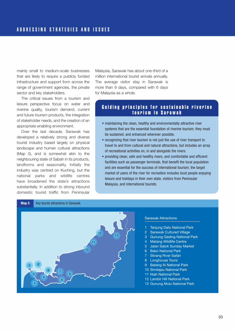
33
A D D R E S S I N G S T R A T E G I E S A N D I S S U E S
mainly small to medium-scale businessesthat are likely to require a publicly fundedinfrastructure and support from across therange of government agencies, the privatesector and key stakeholders.
The critical issues from a tourism andleisure perspective focus on water andriverine quality, tourism demand, currentand future tourism products, the integrationof stakeholder needs, and the creation of anappropriate enabling environment.
Over the last decade, Sarawak hasdeveloped a relatively strong and diversetourist industry based largely on physicallandscape and human cultural attractions(Map 5), and is somewhat akin to theneighbouring state of Sabah in its products,landforms and seasonality. Initially theindustry was centred on Kuching, but thenational parks and wildlife centres have broadened the state’s attractionssubstantially. In addition to strong inbounddomestic tourist traffic from Peninsular
Malaysia, Sarawak has about one-third of amillion international tourist arrivals annually.The average visitor stay in Sarawak is more than 9 days, compared with 6 daysfor Malaysia as a whole.
• maintaining the clean, healthy and environmentally attractive riversystems that are the essential foundation of riverine tourism; they mustbe sustained, and enhanced wherever possible.
• recognizing that river tourism is not just the use of river transport totravel to and from cultural and natural attractions, but includes an arrayof recreational activities on, in and alongside the rivers.
• providing clean, safe and healthy rivers, and comfortable and efficientfacilities such as passenger terminals, that benefit the local populationand are essential for the success of international tourism; the targetmarket of users of the river for recreation includes local people enjoyingleisure and holidays in their own state, visitors from PeninsularMalaysia, and international tourists.
G u i d i n g p r i n c i p l e s f o r s u s t a i n a b l e r i v e r i n et o u r i s m i n S a r a w a k
1312
11
10
9
8
7
1 2
3
4
5
6
Sarawak Attractions
1 Tanjung Datu National Park2 Sarawak Cultured Village3 Gunung Gading National Park4 Matang Wildlife Centre5 Jalan Satok Sunday Market6 Bako National Park7 Skrang River Safari8 Longhouse Tours9 Batang Ai National Park10 Similajau National Park11 Niah National Park12 Lambir Hill National Park13 Gunung Mulu National Park
Map 5 Key tourist attractions in Sarawak

34
M A L A Y S I A I N L A N D W A T E R W A Y T R A N S P O R T S Y S T E M I N S A R A W A K
With the support of local andinternational agencies, the nurturing of theof tourist industry can be an effectivedevelopment tool in the implementation ofthe Millennium Development Goals (MDGs)for the eradication of poverty and itsaccompaniments by directing economicbenefits towards the poor.
This process requires focused policies,plans and actions if the disadvantagedsections of the community are to benefit.This pro-poor approach is focused oncreating suitable tourism locations andattractions, providing locally producedgoods for the tourist industry, and offeringassociated services from local sources. Forvisits to many of the attractions such asparks, caves and longhouses, river travel onexpress boats, longboats, and penambangare an integral part of the experience,ferrying people far and wide. Theseopportunities can provide significant incomefor the rural poor, although the possibility ofnegative social impacts cannot be ignored.
Method of investigating sustainableriverine tourism. The core tourism andleisure study team comprises a SRB projectteam member and a tourism and leisuresub-consultant. The task is to assess thecurrent and potential role of Sarawak’sinland waterway transport system intourism and recreational activities and in travel between tourist destinations, andto identify sustainable riverine tourismdevelopments including those benefitingdisadvantaged rural communities, theirinfrastructure and service requirements.The environmental impact is also beingaddressed. Again, a participatory approachis being adopted, including discussions,
consultations and workshops with stake-holders. This work, being carried out duringStage Two, includes:1. a review of the 2nd Sarawak Tourism
Master Plan 1993–2010, the tourismsection of the INTIMS Report, theMalaysian Tourism Strategy, the MalaysianRural Tourism Plan and other relatedinformation;
2. an analysis of the state’s comprehensivetourist arrival and national park visitorstatistics;
3. an assessment of regional tourist trends,patterns, and length of stay;
4. an assessment of study areas for tourismand leisure development potential andassociated environmental impacts;
5. the role of the SRB in managing thedevelopment of sustainable riverinetourism.
I m p r o v i n g S a f e t y a n dS e c u r i t ySafety is considered by the SRB to be ofparamount importance. The future directionof strategies for river transport safety andsecurity must be to continue to enhanceriver transport safety and security in thecontext of changing patterns of use of thewaterway, to cultivate a safety culture, andto promote the good safety record of theriver systems.

35
A D D R E S S I N G S T R A T E G I E S A N D I S S U E S
The SRB has functions, powers andduties to control and regulate the safety ofwaterborne traffic on the river systems ofSarawak, and in its ports and harbours. Thearea of jurisdiction of the SRB extendsbeyond the inland rivers to the three-milestate territorial waters limit along the coast.As noted in its Strategic Plan 2006–2010,the SRB places great emphasis on makingthe river systems safer, and will continue toconduct safety campaigns.
There is a common perception amongthe general public, and some policymakers,that river transport is unsafe and unclean.People are clearly sceptical about the safetyof travelling by boat, and accidents on therivers nearly always feature as news items.In fact official data demonstrate that watertransport is safer than most other forms oftransport, but there certainly are recurrentissues relating to boats, crews, the rivers,jetties and the environment, that requireongoing attention. Such matters are beingaddressed in the Master Plan and includethe following elements:
Vessels and boats plying the rivers.Vessels and equipment vary greatly inage, design, condition, life-saving gear,capacity and risk from overloading, andprovision of minimal security measures.
Vessels and boat crews. Crew areoften inexperienced, untrained, un-familiar with regulations, disregardsafety measures, and unaware of localprocedures and customs.
River systems. The rivers themselvescan be dangerous with hazardousstretches especially in the upperreaches; sand bars and shallows occur
in the river estuaries; unmarked wrecksand other submerged objects can bedangerous; many stretches of river lacknavigational aids and signage; andinclement weather can change sailingconditions very rapidly. A Marine andRisk Traffic Analysis (MRTA) report hasbeen proposed as a requirement, to besubmitted by any parties wanting toconstruct any structures within the rivers.
Terminals and jetties. In upriver ruralareas, safe terminals and jetties are rareor non-existent; many, including some of
• apply a risk management strategy of objectively assessing differentcategories of risk and prioritising enhancement measures accordingly,and continue to monitor risk;
• define a coherent and rational structure of responsibilities among thedifferent agencies involved, and achieve a common, cooperativeapproach among these agencies;
• apply relevant international standards and practices to improve safetymanagement;
• develop a safety culture, promote safety awareness and training, andenforce safety procedures effectively, so that prevention of problemsprevails;
• carry out investigations of serious incidents and casualties in order tolearn lessons for improving safety.
S t r a t e g y f o r e n h a n c i n g s a f e t y a n d s e c u r i t y

36
M A L A Y S I A I N L A N D W A T E R W A Y T R A N S P O R T S Y S T E M I N S A R A W A K
the larger new ones, are poorlydesigned; illegal jetties do not complywith regulations and may be difficult andrisky to use; operational procedures takelittle account of safety; and movement ofpassengers and cargo between land andboat is often precarious.
Environment and safety. Substantialamounts of floating debris, particularlylogs and solid waste, present a hazard;and there is a lack of facilities at terminalsfor boats to discharge bilge water,sewage and solid waste.
Enforcement. Enforcement isproblematic due to insufficient man-power for this purpose in the SRB; thereis often a lack of training among shipsurveyors, inspectors and enforcementofficers; there is a need to regularlyreview and update rules and regulations;and there is a lack of communication and cooperation among enforcementagencies.
These and similar issues of safety andsecurity are being addressed andrecommendations for improvement made inthe Master Plan.
Method of investigating safety andsecurity. The procedure for investigatingsafety and security included the following,being carried out during Stage Two:1. a full risk analysis of all recorded fatalities,
casualties, and incidents relating to watertransport over the last decade, is beingundertaken, and this will proved adatabase for tracking future trends.
2. a comparison is being made ofinternational norms and practices for the
management of water transport safetyand security with the current situation inSarawak; this will enable the identificationof shortcomings and inadequacies inlocal regulations and procedures.
3. the two preceding sets of findings willprovide the basis for enhancing safetyand security, and introducing specificmeasures and training for improvementsin local river transport and terminaloperations.
4. a critical assessment is being made ofwhether the International Association ofLighthouse Authorities Risk ManagementTool for Ports and Restricted Waterways(employing both its qualitative andquantitative risk assessment criteria) isappropriate to the scale of operations forwhich the SRB is responsible.
A d v o c a t i n g E n v i r o n m e n t a lS u s t a i n a b i l i t y a n dE n h a n c e m e n tThe future direction for environmentalmanagement of Sarawak’s river systemsneeds to be the reinforcement of the SRB’sexisting efforts to remove, minimise andmonitor the unfavourable environmentaleffects of riverine transport, and achieve itsvision of clean rivers and the preservation ofcultural heritage.
Protecting and enhancing the riverenvironment is a critical issue that cutsacross many different aspects and vestedinterests. The three components of inlandwaterway transport (commercial inlandwaterway transport, community waterwaytransport and riverine tourism), safety andsecurity operations, and institutionalmanagement of the sector, all have

37
A D D R E S S I N G S T R A T E G I E S A N D I S S U E S
implications for the environment. Althoughthe SRB’s emphasis on clean rivers andpreserving the cultural heritage has had asignificant impact, there are stillenvironmental issues related to existingriverine transport operations, and the majorexamples of these are as follows:
Vessel operations. The main issuesrelate to air pollution from engineexhausts; disposal of bilge water andother waste in the river; disposal ofgarbage by operators and passengersinto the river; floating logs and otherdebris; and riverbank erosion exacer-bated by fast moving craft.
Ports, terminals and wharves. Thedisposal of waste oil, sewage, garbageand other materials into the river at thesedestinations is a serious problem, withcumulative and disfiguring results.
Other landside facilities. Uncontrolleddisposal of various waste materials andhousehold garbage into the river is aperpetual problem.
Riverine tourism. Promotion of riverinetourism risks damaging the culturalheritage, and therefore requires pre-cautionary measures.
Safety enforcement. In addition topersonal injury or loss of life, accidentson the waterway can cause environ-mental damage: through spillage of fueland engine oil; abandonment of boat orother wreckage in the river; and loss ofcargo on the river which, in the case ofhazardous materials, could have seriousconsequences.
Institutional capacity. Lack ofresources and regulatory authority todeal with all existing environmentalconcerns creates uncertainty and allowsundesirable outcomes to occur.
The Master Plan’s proposal is to increasethe utilization of Sarawak’s river systems,but the volume of traffic on the rivers willfurther increase the risk of environmentaldamage. Appropriate measures are there-fore essential to mitigate such risks.
Method of investigating environmentalsustainability and enhancement. Issuesof environmental sustainability andenhancement are subsumed in each of theother components because of their cross-cutting character and are being dealt with inthose contexts. The relevant proceduresbeing carried out during Stage Two include:1. reviewing the extent of relevant
current environmental problems andrecommending how they should beaddressed;
2. assessing the level of potentialenvironmental risks associated withproposed improvements, and identifyingameliorating measures.

38
M A L A Y S I A I N L A N D W A T E R W A Y T R A N S P O R T S Y S T E M I N S A R A W A K
A separate environmental consultancywill be carried out during Stage Three of thestudy, once the content of the completeMaster Plan has been defined in moredetail. This will aim to:1. reinforce SRB’s capacity to protect and
enhance the environment;2. make an overall assessment of the
environmental implications of the MasterPlan proposals;
3. carry out an initial environmentalexamination of those measures identifiedas having significant risks;
4. define the institutional strengtheningmeasures required by the SRB to fulfil its obligations in managing theimplementation of the Master Plan.
P r o m o t i n g I n s t i t u t i o n a lS t r e n g t h e n i n g a n dC a p a c i t y B u i l d i n gThe SRB, along with other governmentagencies with responsibilities for inlandwaterway transport, will be operating withina legal and regulatory framework, withhistorical functions, powers, duties, andpractices that may have been satisfactory inthe past, but may be inappropriate in thefuture. It is therefore timely to review thecurrent functions, powers and duties of theSRB with a view to responding positively tofuture challenges, thereby enhancing theeffectiveness and efficiency in managinginland water transport in Sarawak.Alongside this, it would be appropriate forthe SRB to review and revise itsorganisational structure to ensure that it hasthe resources, competencies andcapabilities to fulfil its duties. There areseveral issues that could usefully be
addressed to enable the SRB to optimise itsefforts, as follows:
Organizational structure in the SRBcurrently results in an imbalance in staffcomposition so that about 95% of staffcomprise administrative support andenforcement personnel, leaving just 5%to perform all other functions such assenior and middle management, and theprofessional roles such as those oflawyers, accountants, engineers, andcomputer specialists. This structure hasmajor implications for the way that theSRB is able to function. Such a structurein an organization like the SRB makesplanning difficult, and reactions tochanging circumstances frustratinglyslow. To effectively fulfil its function, theSRB requires a different structure.
Funding for the SRB, a government not-for-profit agency, comes from twosources: government grants and revenuefrom service charges for some activities.There is no clear linkage between thecosts associated with its duties and thegrants and revenues available for fulfillingthose duties (such as barrage operation,installation of navigational aids, clearanceof wrecks, maintenance of terminals andthe like). Issues raised in the section onsafety and security clearly imply a needfor adequate financial resourcing.
Legal framework issues highlight theneed for adequate powers to enable theSRB to carry out its functions and dutiesincluding controlling and regulatingwaterborne traffic (including pilotage);keeping water clean and minimisingpollution generally; improving navigation

39
A D D R E S S I N G S T R A T E G I E S A N D I S S U E S
with respect to debris; providing buoysand aids for navigation; providing and maintaining wharves and jetties;preventing obstructions; makingrecommendations for river safety andprevention of collisions; operating and maintaining the barrage system;planning and making developmentalrecommendations to government; andreducing erosion of riverbanks. SRB also provides and manages extensivepassenger boat services.
Overall, SRB has responsibility forthe enforcement of safety and securitymeasures on certain terminals and rivervessels. However, it is not always clearwhere the functions of the MarineDepartment end and those of the SRBbegin, nor is it satisfactory to have theSRB as both operator and enforcementagency.
Environmental responsibilities of theSRB include reducing the rate ofriverbank erosion; removing anddisposing of all pollutants, floating debris,and dilapidated fencing; and preventingrubbish from accumulating in or flowingdown the river. Whilst ensuring vessels,terminals and wharves have facilities todischarge bilge water, sewage, and solidwaste is itself a major task, being the soleenvironmental agency responsible for thepristine condition of all rivers in the stateis a complex and difficult undertaking.
Method of investigating institutionalstrengthening and capacity building. Theproposed strategy to review and analysethe institutional strengthening and capacitybuilding capabilities of the SRB is being
carried out in five stages during Stage Two,as follows:1. audit current functions, powers and
duties of the government agenciesinvolved in the inland waterway transportsector, including those outside thecurrent ordinance, their funding, revenueand costs, to assist in identifyinginadequately covered or overlappingjurisdictions;
2. undertake an organizational structureanalysis of the SRB in terms of humanresources, staffing costs, duties andresponsibilities, including an assessmentof the adequacy of funding and revenuearrangements against the costs offulfilling its functions, powers and duties,and a SWOT analysis of competencies,
Plan & makerecommendations
to Government
Manage &maintain wharfs
THE NEED TO CLARIFY THE FUNCTIONS OF SRB• Port Authority• Inland Waterway Authority (SRB)• Terminal regulator & operator• Environmental protection
SRB
Regulate traffic
Operate &maintainbarrage
Safety onrivers
Preventobstructions
Provide wharfsand maintain
Keepwater clean
Reduce erosionof banks
Improvingnavigation
Provide buoysand aids
Figure 2 Institutional strengthening and capacity building

capabilities, and resources;3. review international norms and practices
regarding the functions, powers andduties of inland water transport ports,riverine organizations and agencies, anduse this information as the basis for acritical evaluation of Sarawak’s riverineorganizations and agencies with particularreference to conflicting, irregular,overlapping, and omitted provisions injurisdiction, functions, powers, andresponsibilities for commercial rivercraft, terminals and jetties.
4. consider the implications of the MasterPlan in terms of new or potentialfunctions, powers, and duties of theagencies involved, especially for theSRB, for which consideration of revisedfunding and revenue arrangementsunder different assumptions andscenarios will be required;
5. propose institutional strengthening andcapacity building requirements for a 5-year Plan of Action and long-termplanning to 2020, by: conducting a gapanalysis between the SRB’s current andpreferred organizational structure;conducting a training-needs analysis forthe SRB at the organization and individuallevels for key staff; identifying priority-training needs for the improvement of jobcompetencies for key departments andstaff; identifying human resourcedevelopment strategies and priorities inthe areas of planning, project evaluation,modern inland waterway technologiesand safety; conducting workshops,training sessions and seminars toenhance understanding and explore bestpractice in management and operation ofan inland waterway system.
A d v a n c i n g S u s t a i n a b l eD e v e l o p m e n t , P u b l i cP a r t i c i p a t i o n , C o m -m u n i c a t i o n S t r a t e g y , a n dK n o w l e d g e M a n a g e m e n tA number of strategies have been adopted in order to engage stakeholdersthroughout Sarawak in an education andawareness programme. This has involvedorganising newsworthy events relating tothe rivers that involve all levels of society,including the civil, private and publicsectors, that can be enjoyable as well aseducational. The process and key lessonslearnt during the study period aredocumented in brochures, manuals,slides, conference papers, DVDs or othermedia. These are used for distribution andpresentation to the community, schools,universities, other government bodies,local and international forums.
Another strategy adopted is tocollaborate with local media, withcontributions from all stakeholders torelease a series of articles about the riversof Sarawak. The articles focus oncommunity, river transportation andinfrastructure, rural poverty, river tourism,river safety, policy, management and
40
M A L A Y S I A I N L A N D W A T E R W A Y T R A N S P O R T S Y S T E M I N S A R A W A K

environment, for public consumption.Ultimately these articles will be assembledas a book entitled ‘Reflections fromSarawak’s Rivers’, as documentation ofissues faced by the rivers in Sarawak .
Other challenges for the education andawareness programme include: under-standing stakeholders specific needs indifferent locations and designingappropriate events; creatively developinginteresting educational events andactivities to ensure participation and long-term learning; optimising the use of limitedresources, time and budget in reachingpeople throughout the state; and applyingresources and appropriate methods formeasuring the quantitative and qualitativesuccess of events and activities.
Method of investigating sustainabledevelopment, public participation,communication strategy and knowledgemanagement. Efficient communication atand between all aspects, (1)-(4), covering:1. concept development: confirm objectives
and research and develop event concept;estimate preliminary budget breakdown;develop detailed education andawareness; these are carried forwardunder (2);
2. stakeholder participation: survey, inter-
view and evaluate preliminary proposalswith inputs from local stakeholders;engage key stakeholders including localResident and District Officer; discusswith community leaders; explore public/private partnerships; seek sponsorships;
3. implementation: mobilize site inspectionsby the SRB and UNDP team; hold the event;
4. knowledge management: quantifydeliverables; compile feedback andprepare post hoc report; eventdocumentation requires updating web-sites, collating event publications, writingarticles for publication in The Borneo Post,and collating the photo gallery.
41
A D D R E S S I N G S T R A T E G I E S A N D I S S U E S

42
M A L A Y S I A I N L A N D W A T E R W A Y T R A N S P O R T S Y S T E M I N S A R A W A K
Everybody has a view!
• Local government official (with a laugh): Everybody wants roads; nobody is interested in river
transportation now.
• Key government decision maker: The rivers are an untapped infrastructure we don’t have to pay
any money to construct, not like roads.
• Rural longhouse resident: My community wants to be modern, have electricity 24 hours, televisions,
hand phones and cars. We don’t want to live in the traditional way.
• Tourism operator: The tourists don’t come all the way to see a modern longhouse made of concrete
with cable TV, they want to see tradition and culture. We have to travel further and further into the rural
areas now for this.
• School headmaster: Education in Malaysia is free, books, uniforms, boarding fees, everything. It is the
standard of the students that we need to be concerned about.
• Tourism consultant: Water quality and the river environment are critical to riverine tourism. No
operator will invest money in developing a tourism business and infrastructure if there is no guarantee
that, next year, the rivers will not be polluted due to activities up-stream.
• SRB staff: The local community knows the rivers better than anyone else; we don’t need to educate
them.
• Local tourist: I only booked the boat to Mulu because the flights were full. The boat journey is longer,
costs more, and then, if the water level is low, I even have to get out and help carry the boat!
Box 6 Stakeholder feedback on promotion of river transportation

43
T W O P I L O T P R O J E C T S
If funding is available, two pilot projects willbe initiated during Stage 3 of the study asa precursor to the full-scale implementationof the Master Plan once approved. Thepilot projects afford the opportunity to verifythe feasibility and effectiveness of theproposals to improve facilities and safetymeasures for rural riverine communities.
P i l o t P r o j e c t O n e :I m p r o v i n g r i v e r f a c i l i t i e sa n d c a p a c i t y b u i l d i n g i ns a f e t y , f o r l o c a lc o m m u n i t i e s i n M e n d a m i ta n d L i m b a n g .Improving river facilities, and capacitybuilding safety measures for localcommunities in Mendamit and LimbangContextThere are about 30 communities, 13 schoolsand 3 clinics along the Limbang, Mendamitand Tarikan Rivers up to the ‘back’ entranceof the Mulu National Park via theHeadhunters’ Trail. A large number of thelocal community, numbering over 20,000,are totally dependent on the rivers fortransportation. In addition, up to 700 touristsa year take boats from Nanga Mendamit toMulu and this number is expected to grow.
Due to the topography, soil conditionsand scattered nature of the communities,there are no immediate development plansfor roads from Nanga Mendamit onwards.However, many of the existing facilities,including landings and navigation channelsfor river transport used by students, clinicpatients, villagers and tourists, are in poorcondition and potentially unsafe.
Objective• to develop a public, private and
community partnership to ensure thecomfort, safety and well-being of the ruralcommunities and tourists by improvingthe basic amenities such as river landings,safety equipment, lighting, signage andclear navigable channels;
• to improve the quality of life of the ruralcommunities dependent on rivertransportation by providing facilities thatalso encourage use by tourist operatorsand growth of tourist numbers, thusgenerating income for the ruralcommunities that provide boat andhomestay services;
• to develop capacity building and a cultureof river safety through a trainingprogramme for river rescue, navigation,cardiopulmonary resuscitation (CPR) andfirst aid;
• to develop a sustainable approach to river management through communityinvolvement, classification of rivers, and
Corporate Social Responsibility (CSR) is about doing good and doing well.It is about corporations rising to the social and environmental challengeshumankind is facing. Increasingly, UNDP engages businesses through CSRand public-private partnerships in support of national developmentaspirations. We seek to get some convergence of cultures, building thecapacity of corporations to view development and environment issuesfrom new perspectives.
New partnerships, sharper management tools and better national andlocal policy frameworks are all necessary to make a difference.Individuals, corporations, government and civil society alike have a role toplay. While CSR on its own can only bring about little islands ofimprovement, collectively it has the potential to make a sea change inprogress. Let the private sector therefore step forward as trustedambassadors for Sarawak’s rivers.
Box 7 Public private partnerships
Source: Tan, 2008, Borneo Post

improvement of river buffers, vegetationand river maintenance.
Project components1. Undertake a survey of river conditions for
river clearing and design of adjustablepontoons with landing steps, safetyequipment, lighting, and signage; andfurther improve the condition of riverbanks.
2. Utilize lightweight and modulartechnology designs for the pontoons toreduce cost and allow communityparticipation in assembly and maintenance.
3. Develop an ongoing safety trainingprogramme to be delivered by the SRBfor long-term upgrading, practice andmaintenance of safety skills.
The total length of the Limbang River fromthe mouth to Tarikan is 298 km, and the facilities required are extensive.Consequently, the initial phase will coveronly the communities from Nanga Mandamitto Tarikan: this involves 5 schools, 1 clinic, 7 communities with (shared) tourist landingsroutinely used by up to 2,900 persons plus about 700 tourists a year.
This project can be implemented within atime frame of 10 to 12 months. The outputswill include the construction of 5 pontoonsand integrated facilities, and the training ofup to 1,000 community members and rivertourism services in safety training.
If the lightweight and modular integratedpontoon systems, lighting, signage andsafety equipment are deemed to besuccessful and cost effective, thesesystems could also be adopted by othercommunities in Limbang, Tatau, Ulu Baram,Kapit, and Belaga, where there is a need.With cleared waterways and proper landingfacilities, additional services like floatinglibraries and trading banks become an
option in improving the quality of life forthese rural communities.
P i l o t P r o j e c t T w o :D e v e l o p i n g t h e R i v e r s -S t r e e t s o f T o m o r r o w ( 2 )Improving service delivery to the rural rivercommunities of Daro, Matu and Dalat, MukahDivisionContextThere are over 45,000 people living in ruralcommunities in Daro, Matu and Dalat. Manyof these communities and 29 schools along
44
M A L A Y S I A I N L A N D W A T E R W A Y T R A N S P O R T S Y S T E M I N S A R A W A K
CONCRETEPATH
REINFORCEDEMBANKMENT
RAMPSTEPS LIFE BUOY
SOLAR LIGHTS(FOR NAVIGATION)
FLOATING PONTOON BOAT PLANTING
High Water Level
Low WaterLevel
SIGNAGE
Figure 3 Construction of pontoon and facilities for Limbang and Mendamit Rivers

the Igan, Oya and Lassa Rivers aredependent on the rivers for transportationand support of their livelihood – as in thecase of sago production and processing.
There are no immediate developmentplans for roads in the Daro and Matudistricts. The communities use express-boat services and small channels asshortcuts to reach larger towns such asSibu, Sarikei and Mukah, in order to accessservices such as banks and clinics. Theriver is also a source of water for drinkingand bathing – especially during the dryseason.
The Kut Canal, river and channels areused by the local community as a means oftransportation, as a water source, and as atoilet for the disposal of sewage. Thisproject will address the multiple uses ofwaterways that overlap in rural rivercommunities to increase the standard andquality of life in these areas.
The establishment of the SarawakCorridor of Renewable Energy (SCORE) willhelp to ensure the growth and improvementof this region. The Authority has, as apriority, the improvement of basic amenities,public services and public transportation insupport of rural growth and development.
Objective• to clear and improve community
navigation channels for safe and easyaccess;
• to improve services to rural communitiesby bringing mobile services such as alibrary, banks and healthcare to ruralareas via river transportation;
• to ensure a sustainable river environmentand improve quality of life for rural rivercommunities by developing improved
sewage systems, and thus reducingpollution of the river and sources of water.
Project components1. Survey and clear Kut Canal and other
channels that link the Igan, Oya andLassa Rivers, and work on improving theriverbanks.
2. Deploy a floating mobile library and bank,to increase services to the nearby ruralcommunities, working in partnership withthe Education Department and theprivate sector.
3. Construct an economical andsustainable sewage system for ruralcommunities (of a type developed inBangladesh) that can be constructedand maintained by individual communitymembers.
This project can be implemented within atime frame of 12 to 18 months. The outputswill include the clearance by the SRB ofapproximately 30 km along the Kut Canaland channel links. The mobile library andbank will service Daro and involve a route ofabout 120 km that includes about 15,000people and 23 schools, and will be run for atrial period of 12 months. There will betraining to raise awareness of the need for improved sewage disposal andimplementation of 20 rural sewage systemsin 5 communities.
In the long-term it is planned to introducean holistic plan to improve basic amenitiesand public health services to all of theserural communities. The rivers provide alargely untapped infrastructure that can beutilized to improve service delivery. If thesemobile service boats and sewage systemsprove successful, there is the potential toincrease service delivery to the entire districtof Mukah and beyond.
45
T W O P I L O T P R O J E C T S

46
M A L A Y S I A I N L A N D W A T E R W A Y T R A N S P O R T S Y S T E M I N S A R A W A K
Tanjung Budu
S.Dar
o
Batang
Lass
o
S. Rasau
S.A
ssan
S. Kut
S. Sanar
S. Baoh
Sg Mukah
S. Sikat
S. Penipah
S. Paku
S.TillianS.
Elas
S. Kabang
S.Sa
wai
SgLebaan
S. Bunau
S. SiungS. Pasai
S. Bawan
S. Kanowit
Kg. Mudan
P. Patuk
Daro
Matu
Julau
Kanowit
Mukah
Dalat
Kg. Bawang
Kg. Beruan Besar
Kg. Matadeng
Oya
KenyanaR. Manggal
R. Ingka
R. Bakar
R. Jabu
R. MajaR. PanjangR. Iala
Tanjung Mahat
Tanjung Jerijeh
Kg. Muara SelalangRajang Mangrove
Kg. Grigat
R. Rentap
R. Kana
Durin
R. Briak
R. Sakai
SibintekSekuau
Keranji
Teku
N. Tamin
Tanjung Sirik
P. Beruit
Kg. Sai
Kg. Tekajong
Kg. Kelupu
Paloh
R. Empaling
Belawai
Tanjung Manis
Nibong
S. Paloh
S.B
elaw
ai
Selalang
RajangS. Batang
R. Dato
Bintangor
Igan
Passin
Sarikei
Sibu
Kg. Judan
Kg. TutusTowns with banks
Roads
Existing Boat Express Route
Community Transport (<20seaters)
Safe Crossings
LEGEND
Towns without banks/supermarket/entertainment centres
Daro, Matu, Dalat Districts:~ 4 towns~ About 29 schools~ Communities travel to Sibu, Sarikei or Mukah for banking, supplies, entertainment~ There is need for proper infrastructure such as jetties, signage, safety buoys/lights, dredging of channels.
Map 6 Community water transport network in Mukah Division

47
D e v e l o p m e n t o f P r o j e c t D e s i g n• The original terms of reference defined 23 navigable
rivers for study over the project’s duration of oneyear. However, the vastness of Sarawak, thedifficulty of travel in many rural areas of the state,and a lack of available data on inland watertransport, made it impossible to complete such astudy within twelve months. Consequently theproject team ran a workshop to redefine and limitthe study to three major navigable systems linked tocore passenger and freight routes, rural riverinepoverty areas, and tourism activities.
• In general terms, strategic master planning (carriedout by Sarawak’s State Planning Unit), tourism,and community transport are not part of the coreactivity of the Implementing Partner, the SarawakRivers Board. An SRB Planning Team wastherefore set up to ensure that the SRB is fullyinformed and involved, and that members of thePlanning Team participate on a continuing basis inthe planning process.
• The project aimed at increasing the participation ofSRB team members to encourage technology andknowledge transfer and maintain continuity indeveloping the pilot projects and negotiating apublic-private partnership. This strategy wasadopted with the aim of building capacity in theareas of project conceptualization, business plans,river promotion and corporate social responsibility.
• A key requirement of the project was to hire localconsultants for the detailed component of the study,working under an international consultant. This hasnot proved easy as inland waterway transport hasnot been the focus of research or investigation inMalaysia, and there are few calibered transporteconomists specializing in this field.
• The rivers are greatly affected by ‘king’ tides, the‘landas’ (monsoon season) and ‘kemarau’ (dryseasons). During these periods, travel is severelyimpeded due to flooding and strong currents or, incontrast, by the difficulty of navigating in the upperreaches of the rivers when water levels are very low.Timing of fieldwork and surveys to avoid oraccommodate these conditions is essential.
• Consultation with local communities from the verybeginning of a project can provide importantinsights into the issues that need to be addressed,the people that should be interviewed andacknowledged, and the pitfalls to be avoided thatare not necessarily obvious to members of theproject team coming from different environments.
E f f e c t i v e u s e o f m e d i a a n dp u b l i c i t y• There are notable benefits in maintaining a regular
presence in the local newspapers, raising aware-ness of the issues relating to the state’s rivers, andadvising people of the objectives and benefits of the study.
• A comprehensive Education and AwarenessProgramme conducted in each of the 11 divisions ofSarawak, has brought together government officialsand enabled them to see for themselves the issuesand challenges people are confronted by whenliving in a rural, riverine environment.
L e s s o n s L e a r n t
48
• Taking responsibility for river management.Giving agencies clearly defined responsibilities andthe authority to enforce the requisite regulations,would improve conditions on and around thewaterway system. River management is not aclearly defined or designated responsibility, andjurisdictions are unclear and overlap. This inevitablyresults in confusion, uncertainty, and anunwillingness to take urgently needed initiatives.
• Investing in rivers. Changing the mindset ofdecision makers in positions of authority andinfluence so that they are enthusiastic aboutinvesting in the rivers as a long-term, economicallyfeasible, environmentally sustainable form oftransportation. Many countries around the world aredemonstrating that inland water transport is atwenty-first century technology worth investing in.
• Project implementation. The project wasdesigned to complete a Master Plan that would behanded to the local agency for implementation.Given the Sarawak Government’s comments thatmany such projects are shelved and notimplemented, the recommendation has been madethat pilot projects should be started while the MasterPlan is being completed, which would provide anopportunity to assess the implementation agency’sneeds for capacity building, and for resolving anyother implementation issues.
• Supporting the Master Plan. Engaging publicand private sector participation, civil society, boatusers and operators, and the travelling public sothat the Master Plan is accepted, owned, andsupported by all stakeholders.
• Identifying an appropriate rivers authority.There is no integrative or authoritative riversmanagement authority. The SRB is charged withtwo core roles: safety and cleanliness; and theirimplementation involves supervision of navigationaids, terminals, riverbanks and related matters. Thelarger issues of strategic planning, riverinfrastructure, promotion of the rivers, and socialresponsibility toward the river communities and theirbasic amenity needs are not part of the SRB’s directresponsibilities. Is this provision really adequate forsuch a major task?
• Enhancing community water transportinfrastructure. Improving facilities for inlandwaterway transport in rural areas should be driven bythe needs of the communities who use watertransport for their daily activities like going to market,to school, to work on smallholdings and onplantations. Tourism should not be the primary driverfor such infrastructure but should access what isdeveloped primarily for the community; communitywater transport is an issue of social responsibility forthe well-being of the local population.
• Revitalizing river transportation. Can the naturaldeath of river transportation be avoided? Aslogging tracks are developed and plans for newroads are announced, existing operators stopinvesting in the maintenance and upkeep of boats,schedules become more irregular, patronagedeclines, and the demise of the system canbecome a self-fulfilling prophecy. Is this inanybody’s best interest?
• Holistic river management. There is an urgentneed to adopt a more holistic approach to themanagement of rivers in all phases of planning,development, conservation, restoration andpromotion.
I S S U E S A N D C H A L L E N G E S

49
S O U R C E S O F I N F O R M A T I O N
P r i n tChan Ah Man, C (2003) River Transport in Batang Rajang, Sarawak: Operations andEconomics, MBA thesis, Irish International University of the European Union, unpublished.
Khoo Khay Jin (2007) Poverty, Inequality and Welfare in Sarawak: Study to IdentifyStrategies and Programmes to Eradicate Poverty and Improve Employment and EquityRestructuring in Sabah and Sarawak, UNDP Malaysia, unpublished.
Lee Yong Leng (1970) Population and Settlement in Sarawak, Asia Pacific Press,Singapore.
Leete, R (2007) Malaysia: from Kampung to Twin Towers: 50 Years of Economic and SocialDevelopment, Oxford Fajar, Shah Alam, Malaysia.
Malaysia Economic Planning Unit (2001) Eighth Malaysia Plan 2001–2005, Kuala Lumpur,Malaysia.
Malaysia Economic Planning Unit (2006) Ninth Malaysia Plan 2006–2010, Kuala Lumpur,Malaysia.
Sarawak Rivers Board (n.d.) Strategic Plan for 2006–2010, PowerPoint presentation.
SRB-UNDP (2007) Sarawak Inland Waterway Transport (SIWT) System Study, Stage OneConcept Master Plan (Inception Report), August, unpublished.
SRB-UNDP (2007) Sarawak Inland Waterway Transport (SIWT) System Study: Stage 1:Inception Report, PowerPoint presentation to National Steering Committee forEndorsement, September, unpublished.
State Planning Unit (2007) Sarawak Facts and Figures, Kuching.
The Borneo Post: series of 18 articles on the Sarawak Inland Waterway Transport PublicAwareness and Education Programme, in The Sunday Post, from 18 March, 2007 to 04November, 2007.
UNDP (2006) Sarawak Inland Waterway Transport (SIWT) System Study, ProjectDocument, unpublished.
I n t e r n e tSarawak Electronic Government website. http://www.sarawak.gov.my
Sarawak Rivers Board website. http://www.riversboard.gov.my
UNDP Malaysia website. http://www.undp.org.my
50
E a r l i e r R e p o r t s i n S e r i e s1 Malaysia’s Peat Swamp Forests: Conservation and Sustainable Use,
Kuala Lumpur, 2006.
2 Achieving Industrial Energy Efficiency in Malaysia, Kuala Lumpur, 2006.
3 Protecting the Ozone Layer: Malaysia Implementing the MontrealProtocol, Kuala Lumpur, 2007.
4 Malaysia Generating Renewable Energy from Palm Oil Wastes,Kuala Lumpur, 2007.
5 Community Forestry and Sustainable Forest Management in Sabah,Kuala Lumpur, 2008.
6 Malaysia Developing A Solid Waste Management Model for Penang,Kuala Lumpur, 2008.
Copies of this current report, as well as earlier reports in this series, can be obtainedby writing to:
Chung Tsung PingAssistant Resident Representative (Programme)Wisma UN, Block C,Kompleks Pejabat Damansara,Jalan Dungun, Damansara Heights,50490 Kuala Lumpur, Malaysia
Email: [email protected] or [email protected]
P R E V I O U S R E P O R T S I N T H I S U N D P S E R I E S

United Nations Development ProgrammeWisma UN, Block C, Kompleks Pejabat Damansara Jalan Dungun, Damansara Heights, 50490 Kuala Lumpur, Malaysia.
Tel: 03 2095 9122 Fax: 03 2095 2870 www.undp.org.my