
Lineaments Analysis Determined from Landsat Data ...scienceasia.org/2004.30.n3/v30_269_278.pdf ·...
10
Chiangmai Bangkok Thailand Study area Loei Laos 100 0 200 Km N 15 20 97 E o 100 10 5 N o 97 o 106 o 5 o 105 o o 20 km 102 ํ 24' 102 ํ 20 0 10 N 101 ํ 30' o 18 ํ 05' 101 ํE 18 00' 17 ํ 45' 17 ํ 12' N 17 ํ 30' Figure 1 Neawsuparp K. INTRODUCTION Loei area, the major province of NE Thailand close to Laos (Fig. 1), has been a focus of interest for several ScienceAsia 30 (2004): 269-278 Lineaments Analysis Determined from Landsat Data Implication for Tectonic Features and Mineral Occurrences in Northern Loei Area, NE Thailand Kachentra Neawsuparp 1,2* and Punya Charusiri 1* 1 Department of Geology, Faculty of Science, Chulalongkorn University, Bangkok, 10330, Thailand. 2 Geological Resources Conservation and Management Division, Department of Mineral Resources, Bangkok, 10400, Thailand. * Corresponding author, E-mail: [email protected] and cpunya @chula.ac.th Received 25 Feb 2004 Accepted 23 Jun 2004 ABSTRACT: Digitally enhanced Landsat TM5 images along with geological and mineral occurrence information were applied for investigation of lineament systems in the northern Loei area, NE Thailand. Prior to visual interpretation, enhancement process was performed, including contrast stretching, edge enhancing and directional filter analyses. Image interpretation indicates 3 major lineament systems: north-south, northwest- southeast, and northeast-southwest trending lineaments. The north-south trending lineaments are inferred to be closely related to substantial, nearly parallel thrust faults and fold axes, which, to some extent, follow the major and regional structural feature. Combination of major lineaments with pre-existing structural geology is useful for delineating tectonic features of the area. The overlay of mineral occurrences onto the lineament map indicates that the mineralizations have good coincidence not only with the shorter in northeast-southwest lineaments intersected by the longer in northwest-southeast lineaments but also with the intrusive igneous bodies. The mineral occurrences are mostly concentrated in areas of high-density lineaments. Our preliminary analysis also indicates that lineaments from Landsat interpretation fit fairly well with those of the geologic data. It is concluded that lineaments observed from enhanced spaced-borne images can be used to comprehend the tectonic setting and to select the target areas for follow-up mineral exploration. KEYWORDS: Landsat image, lineament, mineralization, northeastern Thailand, Loei, tectonic. decades due to its significant mineral resources 1- 4 . Jacobson et al. 5 made the first systematic mapping for metal-deposit investigation of the Loei area and its surroundings. Charusiri (1989) made a reconnaissance Fig 1. Map of the Loei study area with major district boundary and overlain Un-enhanced image data and Index map of Thailand showing the area under study.
Transcript of Lineaments Analysis Determined from Landsat Data ...scienceasia.org/2004.30.n3/v30_269_278.pdf ·...

Chiangmai
BangkokThailandStudy area Loei
Laos
1000 200 Km
N
N
15
20
oo
97 Eo 100
10
5 No
97o
106o5o
105o
o
o20
km
102 ํ 24'102 ํ
200 10
N
101 ํ 30'
o
18 ํ 05'101 ํE
18 00'
17 ํ 45'
17 ํ 12' N
17 ํ 30'
Figure 1 Neawsuparp K.
INTRODUCTION
Loei area, the major province of NE Thailand closeto Laos (Fig. 1), has been a focus of interest for several
ScienceAsia 30 (2004): 269-278
Lineaments Analysis Determined from Landsat DataImplication for Tectonic Features and Mineral
Occurrences in Northern Loei Area, NE ThailandKachentra Neawsuparp1,2* and Punya Charusiri1*
1 Department of Geology, Faculty of Science, Chulalongkorn University, Bangkok, 10330, Thailand.2 Geological Resources Conservation and Management Division, Department of Mineral Resources,
Bangkok, 10400, Thailand.
* Corresponding author, E-mail: [email protected] and cpunya @chula.ac.th
Received 25 Feb 2004 Accepted 23 Jun 2004
ABSTRACT: Digitally enhanced Landsat TM5 images along with geological and mineral occurrence informationwere applied for investigation of lineament systems in the northern Loei area, NE Thailand. Prior to visualinterpretation, enhancement process was performed, including contrast stretching, edge enhancing anddirectional filter analyses. Image interpretation indicates 3 major lineament systems: north-south, northwest-southeast, and northeast-southwest trending lineaments. The north-south trending lineaments are inferredto be closely related to substantial, nearly parallel thrust faults and fold axes, which, to some extent, followthe major and regional structural feature. Combination of major lineaments with pre-existing structuralgeology is useful for delineating tectonic features of the area. The overlay of mineral occurrences onto thelineament map indicates that the mineralizations have good coincidence not only with the shorter innortheast-southwest lineaments intersected by the longer in northwest-southeast lineaments but also withthe intrusive igneous bodies. The mineral occurrences are mostly concentrated in areas of high-densitylineaments. Our preliminary analysis also indicates that lineaments from Landsat interpretation fit fairly wellwith those of the geologic data. It is concluded that lineaments observed from enhanced spaced-borneimages can be used to comprehend the tectonic setting and to select the target areas for follow-up mineralexploration.
KEYWORDS: Landsat image, lineament, mineralization, northeastern Thailand, Loei, tectonic.
decades due to its significant mineral resources1- 4.Jacobson et al.5 made the first systematic mapping formetal-deposit investigation of the Loei area and itssurroundings. Charusiri (1989) made a reconnaissance
Fig 1. Map of the Loei study area with major district boundary and overlain Un-enhanced image data and Index map of Thailandshowing the area under study.

270 ScienceAsia ScienceAsia ScienceAsia ScienceAsia ScienceAsia 30 (2004)30 (2004)30 (2004)30 (2004)30 (2004)
unconformably overlaid by alternated strata of shaleand siltstone with tuff and intercalated limestone (BanNong Formation). Intensely folded chert (Pak ChomFormation) of Middle to probably Paleozoic age12 isrestricted to the western part. The chert unit is situatedadjacent to spilitic basaltic rocks ranging in age fromDevonian to Permian.13 Both chert and basalt unitsform a long, narrow north-south trending belt. Thisbasaltic unit extruded on the sea floor and formed hugemasses of volcanic tuff and pillow lava associated withsporadic manganese deposits. Moreover, serpentinitebodies, exposed sporadically as a narrow north-southtrending zone, have been reported in the eastern partof the Loei area.4 In Late middle Devonian toCarboniferous; thick graywacke intercalated with shaleand reef limestone (Wang Saphung Formation) wasdiscovered in several places. Late Paleozoic, reeflimestone (Tham Nam Maholand, Huai E-Lert and PhaDua Formations) lie unconformably over the olderrocks. Felsic rhyolitic tuff and granodiorite of mostlyTriassic age3 cover a large area located mostly in thecentral part of the investigated area. Lower Jurassicnon-marine sediments of the Khorat Group occupyprincipally in the eastern margin of the Loei area.
In the study area, we recognize two major structuralfeatures, viz. folds and faults. The main faults and foldaxes orient in the north-south direction. Additionally,Bunopas2 and Chairangsee et al.4 reported theunconformities in the mapped area between strata ofdifferent ages, for example, between Permian and LateTriassic and between Lower Carboniferous andDevonian. However, they are stratigraphically poorlydefined.
Bunopas14 recognized the Loei area as part of themajor fold belt called “ Loei Fold Belt” which correspondto some extent with the Loei - Phetchabun – Ko Changvolcanic rocks. . . . . Large anticlines and synclines, whoseaxes are mainly in the north-south direction, arerecorded especially in Silurian and Permian rocksequences. Many folds are dislocated by several sets offaults. Strike-slip faults oriented in northeast-southwestand northwest-southeast directions seem to bedominant and they dislocate major folds and pre-existing thrust faults. Sinistral movement, which is morecommon than dextral movement, is present especiallyin the western part of Loei. This is probably due to thecontinuous clockwise rotation of continental SE Asia.1
The large north-south trending overthrust in the easternpart of Loei area separates Silurian-Devonianmetamorphic rocks from Carboniferous sedimentaryrocks.
IMAGE PROCESSING AND ENHANCEMENT METHODSRemotely sensed images play a significant role in
defining geological structures and tectonic fabrics of
survey on granitic rocks in the Loei area using the 40Ar/39Ar method, and Middle to Late Triassic was proposedfor the major age of granitic magmatism. However, fewworks have been focused on remote-sensinginterpretation of the study region. The pioneer workis that of Jantaranipa et al.6 who applied multispectralscanner (MSS) space-borne images to visualizelineaments of the Loei area. It was demonstrated thatthe selection of target areas for mineral or petroleumexploration could be achieved by using integrated imagedata showing high-density lineaments and relevantmaps.
This study is an attempt to correlate lineaments (orgeologically linear features) visible on Thematic Mapper(TM) Landsat imagery, which has become the essentialremote sensing tool for geological exploration. Thebetter spatial resolution (30 m) of TM imagerycompared to that of the Landsat MSS (80 m) and theextra spectral channels provide more detailedinformation for geological mapping. Many reviewedand specialist papers written on Landsat TM data, suchas Abram et al.7, Crosta and Moore8 and Drury 9, alsoemphasized these advantages. For this study, details oflineaments, including geometry, pattern, distributionand density, are involved in the lineament analysis. Theinterpretation of major lineaments related to thestructural tectonics and the reconstruction of structuralgeologic map was carried out in this work. Overlay ofnew mineral occurrences map onto lineament map hashelped to define these relationships. Not all bands ofthe Landsat images can be applied. Only band-7 imagedepicts good contrast and clarity as earlier applied byCharusiri et al10. In this study, the enhanced images areapplied for interpretation without field support ofground-truth evidences. Interpretation, however, hasbeen done together with geological map of Bunopas2
and Chairangsee et al.4 and mineral occurrences mapfrom Economic Division, Department of MineralResources (DMR), Thailand (Mineral ResourcesDevelopment Project)11.
The study area is located in the northern part of theLoei province at latitudes between 101°and 102° 24¢and longitudes between 17° 12¢ and 18° 05 ¢, as shownin Fig 1.
GEOLOGIC SETTINGThere are various literatures regarding geology in
Loei and neighboring areas. Geologic setting of thispaper is summarized from the report of Bunopas2 atscale 1:100,000 and of Chairangsee et al.4 at scale 1:50,000. According to the geological map of Loei area(Fig. 2), rock sequences begin with Middle Paleozoicmetamorphic rocks, which mainly include quartziteand phyllite. In the eastern part of the area, thesemetamorphic rocks (Na Mo Formation) are

SdenceAsia 30 (2004)
'"::IQ..'"<0
...<0::
.. ..<Ow= I.. '".. .-
... '"= '"<0 .~::I ..
OlE-<
= = ='" '" '"
Os Os Os..
.,., .,~~~
= =os os'S 'S
'" '" Q Q= = ......Q Q ......
~ ~::::=11.- .- OS = == = ,- OS OSQ Q = ,-.-.Q .Q Q ... ...... ... ... = =c5c5~~~
'"..II:~0~~
:E~ ~0 ) ~
~ ! ~ i 1 !:E~" .~ ~]~
IHLiH!H~liLe:;OJ! ~;:j;:j ~ J: e.=.. 5 :t.=,Ii J\
101 IIIIII ~I II00 ~ ~
I~~~]j~~~~ ~~~~ E~ ~~! ooo:!~o 000 u. u. U. m - U. U. u.
~~3~~~i5 §',j!.:g ~ ~ &'i <3 ~ ::; ~~ ~ E g> g> ~ .!i;.~~~- -
E~
~
bM.
§
271
c.>";;]'"<U
";:Eo<
'".;;; ""~ '".;: is... ...
I ~ == .- ~~ = .-
.- 0 =
E of ~
~6~
H,l 8'~0
I}
'"
'0.ce,.,
rJ:J
80\0\.-i
<l)<l)<fJb.()>::CIS....
"@
..<::U"d>::CIS
I'-CIJ0\.-i
0..;-
CIeo<:
;;8S0
J:::"d
<l)~;.c;
0
:5CIS<l)
....
CIS
"oJ0
-J<l)
.s
'0P.-CIS
S
oJu
"500
'0<l)
"
NC)u::
'"
~
~~
i;!~
.S~H
272 ScienceAsia ScienceAsia ScienceAsia ScienceAsia ScienceAsia 30 (2004)30 (2004)30 (2004)30 (2004)30 (2004)
km
102 ํ 24'102 ํ
2 00 1 0
N
10 1 ํ 30'
o
1 8 ํ 05'101 ํE
18 00 '
17 ํ 4 5'
17 ํ 12' N
17 ํ 3 0'
Mae Khon
g Rive
r
N
1 02 ํ 102 ํ 2 4'
2 00 10 km
1 01 ํ 30'18 ํ 0 5'
1 8 00'
1 7 ํ 45'
o
101 ํE
1 7 ํ 30'
1 7 ํ 12' N
(a )(b)
(c ) (d)
F igu re 3 N eaw suparp K .
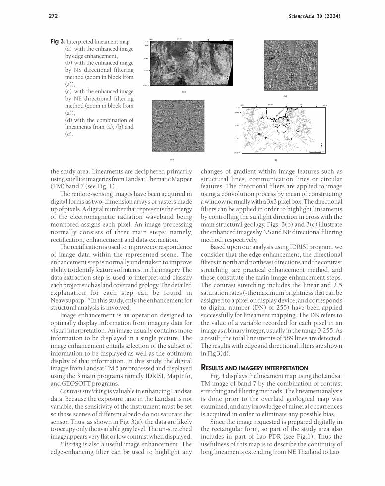
Fig 3. Interpreted lineament map(a) with the enhanced imageby edge enhancement,(b) with the enhanced imageby NS directional filteringmethod (zoom in block from(a)),(c) with the enhanced imageby NE directional filteringmethod (zoom in block from(a)),(d) with the combination oflineaments from (a), (b) and(c).
the study area. Lineaments are deciphered primarilyusing satellite imageries from Landsat Thematic Mapper(TM) band 7 (see Fig. 1).
The remote-sensing images have been acquired indigital forms as two-dimension arrays or rasters madeup of pixels. A digital number that represents the energyof the electromagnetic radiation waveband beingmonitored assigns each pixel. An image processingnormally consists of three main steps; namely,rectification, enhancement and data extraction.
The rectification is used to improve correspondenceof image data within the represented scene. Theenhancement step is normally undertaken to improveability to identify features of interest in the imagery. Thedata extraction step is used to interpret and classifyeach project such as land cover and geology. The detailedexplanation for each step can be found inNeawsuparp.15 In this study, only the enhancement forstructural analysis is involved.
Image enhancement is an operation designed tooptimally display information from imagery data forvisual interpretation. An image usually contains moreinformation to be displayed in a single picture. Theimage enhancement entails selection of the subset ofinformation to be displayed as well as the optimumdisplay of that information. In this study, the digitalimages from Landsat TM 5 are processed and displayedusing the 3 main programs namely IDRISI, MapInfo,and GEOSOFT programs.
Contrast stretching is valuable in enhancing Landsatdata. Because the exposure time in the Landsat is notvariable, the sensitivity of the instrument must be setso those scenes of different albedo do not saturate thesensor. Thus, as shown in Fig. 3(a), the data are likelyto occupy only the available gray level. The un-stretchedimage appears very flat or low contrast when displayed.
Filtering is also a useful image enhancement. Theedge-enhancing filter can be used to highlight any
changes of gradient within image features such asstructural lines, communication lines or circularfeatures. The directional filters are applied to imageusing a convolution process by mean of constructinga window normally with a 3x3 pixel box. The directionalfilters can be applied in order to highlight lineamentsby controlling the sunlight direction in cross with themain structural geology. Figs. 3(b) and 3(c) illustratethe enhanced images by NS and NE directional filteringmethod, respectively.
Based upon our analysis using IDRISI program, weconsider that the edge enhancement, the directionalfilters in north and northeast directions and the contraststretching, are practical enhancement method, andthese constitute the main image enhancement steps.The contrast stretching includes the linear and 2.5saturation rates (-the maximum brightness that can beassigned to a pixel on display device, and correspondsto digital number (DN) of 255) have been appliedsuccessfully for lineament mapping. The DN refers tothe value of a variable recorded for each pixel in animage as a binary integer, usually in the range 0-255. Asa result, the total lineaments of 589 lines are detected.The results with edge and directional filters are shownin Fig 3(d).
RESULTS AND IMAGERY INTERPRETATIONFig. 4 displays the lineament map using the Landsat
TM image of band 7 by the combination of contraststretching and filtering methods. The lineament analysisis done prior to the overlaid geological map wasexamined, and any knowledge of mineral occurrencesis acquired in order to eliminate any possible bias.
Since the image requested is prepared digitally inthe rectangular form, so part of the study area alsoincludes in part of Lao PDR (see Fig.1). Thus theusefulness of this map is to describe the continuity oflong lineaments extending from NE Thailand to Lao

Scienc£Asia 30 (2004)
~N
~....
"""Q....
~-<=-inQ
OQC)....
273
~j
~ L~~" "
&~~1~!~
Ilt%t~>-l'"
ci.'"s
(isu
'5iJ0011.0
~'oJ-;::
0):>0
0)
.s
.s'~P..'"
S~0)s'"0)
E"t:J
0)
.,....P......0)
,S"t:J
0)~
.:i3S0u
-<'<iC)u::

274 ScienceAsia ScienceAsia ScienceAsia ScienceAsia ScienceAsia 30 (2004)30 (2004)30 (2004)30 (2004)30 (2004)
Mae Khong River
(a)
Loei
N
102 ํ 102 ํ 24'
200 10 km
101 ํ 30'18 ํ 05'
18 00'
17 ํ 45'
o
101 ํE
17 ํ 30'
17 ํ 12' N
Mae Khong River
(b)
Loei
N
102 ํ 102 ํ 24'
200 10 km
101 ํ 30'18 ํ 05'
18 00'
17 ํ 45'
o
101 ํE
17 ํ 30'
17 ํ 12' N
Mae Khong River
(c)
Loei
N
102 ํ 102 ํ 24'
200 10 km
101 ํ 30'18 ํ 05'
18 00'
17 ํ 45'
o
101 ํE
17 ํ 30'
17 ํ 12' N
Mae Khong River
(d)
Loei
N
102 ํ 102 ํ 24'
200 10 km
101 ํ 30'18 ํ 05'
18 00'
17 ํ 45'
o
101 ํE
17 ํ 30'
17 ํ 12' N
Figure 5 Neawsuparp K
PDR. In this study, interpretation is performed only inThailand so the Mae Khong River demarcates thenorthern end for this analysis.
In our current investigation, we subdivide the studyarea into three parts, namely western, central andeastern parts by using the difference in pattern,geometry, and density of lineaments. For comparisonof nature and styles of lineaments, the geological mapof this area16 is overlaid onto the lineament map asshown in Fig.4. The length of lineaments is describedin term of major (>10 km long), and minor (<5 km long)lineaments. Linear features of this study area cangenerally be equated with the structural elements suchas faults, joints, or fractures. Minor linear features,such as small-scale fault and joints, are often notapparent on the imagery due to limitations of resolution.
WWWWWesteresteresteresterestern Parn Parn Parn Parn PartttttMain orientations of major lineaments are roughly
in the north-south direction. Some lineament patternstrend in the roughly northeast-southwest direction. Inthe northern part of this zone, long major lineamentsare observed in north-south to northwest-southeastdirections. Lineaments of these directions run fromthe southern part of the mapped area in Wang Saphungand extend to the north in Laos (see also Fig. 1). Theselineaments are located almost at the contact betweenMesozoic clastics and Upper Paleozoic rocks. Thesenorth-trending lineaments in the northern part areshifted tectonically to southeast direction in thesouthern part. In some part, these lineaments aresubsequently crosscut by the northeast-trendinglineaments. The linear features in this zone form a
complex pattern especially in the northwestern (to LaoPDR) by which multi-directional lineaments are clearlyobserved.
Central PartCentral PartCentral PartCentral PartCentral PartCurvi-linear and circular features are unique
features of the central part. The circular features, asindicated by curved drainage patterns in the enhancedimages, mark the area that is concealed by igneousplugs.17 The main lineaments are in the northeast-southwest trend, and they have short length in northernpart (Chiang Khan district in Fig.1). A large number ofmulti-directional lineaments are prominent, but in theother parts a few lineaments are observed. Main rocksof this part, including Permian sediments, Permo-Triassic volcanics, and Triassic granites, are shown inthe geological map (see Fig.2 and Fig.4).
Eastern PartEastern PartEastern PartEastern PartEastern PartMain lineaments in the eastern part align mostly in
the north-south direction. They mostly have mediumlength (about 5-10 km) and are related to some extentwith the major fold axes and the pre-existing north-trending thrust fault. This thrust fault is located at theboundary between Silurian-Devonian metamorphicrocks and Carboniferous sediments. In the vicinity ofthe thrust fault, several minor lineaments are observedto concentrate in the northeast-southwest direction. Itis obvious that both the northwest-trending lineamentsin the south and the northeast-trending in the northcross- cut the north-trending lineaments.
Our interpretation on lineaments displayed incombination with the geological map of DMR16 is
Fig 5. (a) Lineament mapusing combinedenhancement methoddisplay by MapInfoprogram,(b) Lineament mapshowing only theNORTH- trendinglineaments,(c) Lineament mapshowing only theN W - t r e n d i n glineaments,(d) Lineament mapshowing only the NE-trending lineaments.

ScienceAsia ScienceAsia ScienceAsia ScienceAsia ScienceAsia 30 (2004)30 (2004)30 (2004)30 (2004)30 (2004) 275
Mae Khong River
Lo ei R iver
(d)
Χ
Χ1
Χ
Χ σ
σ3
3σ
RR'σ1
N
102 24
200 10 km
18 ํ 05'
18 00'
17 ํ 45'
o
17 ํ 30'
17 ํ 12' N
Mae Khong RiverThrust F.Fault
AnticlineSyncline
(b)
N
102 ํ 102 ํ 24'
200 10 km
101 ํ 30'18 ํ 05'
18 00'
17 ํ 45'
o
101 ํE
17 ํ 30'
17 ํ 12' N
Mae Khong River
FaultThrust F.AnticlineSynclineLinearA. linear
(c)
N
102 ํ 102 ํ 24'
200 10 km
101 ํ 30'18 ํ 05'
18 00'
17 ํ 45'
o
101 ํE
17 ํ 30'
17 ํ 12' N
Mae Khong RiverDiscon.major L.Cont.major L.
Minor linear
(a)
N
102 ํ 102 ํ 24'
200 10 km
101 ํ 30'18 ํ 05'
18 00'
17 ํ 45'
o
101 ํE
17 ํ 30'
17 ํ 12' N
Figure 6 Neawsuparp K.
illustrated in Fig.4.
LINEAMENT ANALYSISLineament analysis, which integrates the analyses
of linear patterns, geometry, kinematics and dynamics,17
can be applied to mineral exploration in an attempt todefine the most favorable locations for mineralconcentrations on the basis of tectonic contexts.
Fig. 5(a) displays all lineaments within the studyarea, which appear difficult to analyze because of thecomplicated features in terms of length and direction.Figs. 5 (b), (c) and (d) show the separated directions oflineaments, trending north-south, northwest-southeastand northeast-southwest, respectively. This scheme ofwork can be easily done using MapInfo program. Foreach lineament direction, the distribution, pattern, andlength of lineaments are considered.
North-South DirectionNorth-South DirectionNorth-South DirectionNorth-South DirectionNorth-South DirectionFig. 5(b) display the north-trending lineaments
distributed essentially in the eastern and western partsof the study area. No distinct lineament of this directionis detected in the central part of the study area. Anumber of lineaments are almost parallel to the majorfolds and faults described above. The main lengths oflineaments are about 20 km whereas some short (lessthan 5 km) lineaments are in the zone of the thrustfault. Most patterns of lineaments are not straight andexhibit the swinging pattern, possibly indicating majorfold axes in this area. The long lineament very close toLoei district is interpreted to represent the normalfault, which is considered to have caused thedevelopment of the Loei river valley (see Figs. 5b and6b).
Northwest-Southeast DirectionNorthwest-Southeast DirectionNorthwest-Southeast DirectionNorthwest-Southeast DirectionNorthwest-Southeast DirectionFig. 5(c) depicts two remarkably straight and
continuous, northwest-trending lineaments, especiallythose in the central part of the area. These majorlineaments presumably extend from southern Loei areato Lao PDR. A number of less obvious lineaments (10km up to 20 km long), can be observed clearly on theimage, form the second-order fractures branching tothe two major faults. Many of the lineaments aredistributed in the northern and southern parts of thestudy area.
Northeast-Southwest DirectionNortheast-Southwest DirectionNortheast-Southwest DirectionNortheast-Southwest DirectionNortheast-Southwest DirectionFig 5(d) illustrates the northeast-trending
lineaments (5-10 km long) that are shorter than theother direction and become denser than those of theother directions. These northeast-trending lineamentswith an average length of 7 km are distributedthroughout the study area. The major lineaments ofthis direction are considerably essential since theypresumably involve in mineralization, which will bediscussed later.
DISCUSSION
Lineaments Related to StrLineaments Related to StrLineaments Related to StrLineaments Related to StrLineaments Related to Structural Tuctural Tuctural Tuctural Tuctural TectonicsectonicsectonicsectonicsectonicsIn an effort to relate lineaments with geological
structures, we subdivide major lineaments intocontinuous and discontinuous patterns. It is interestingthat the discontinuous pattern is well recognized onlyin the eastern part of the study area. The easternmostpart of the discontinuous pattern conforms very wellwith the structural feature mapped as the thrust faultby DMR16 (see Fig. 6b). Moreover, it is essential, with
Fig 6. (a) Major and minorlineaments of the Loeistudy area as visualizedfrom the enhancedLandsat data.(b) Major structuralfeatures deduced froma geological map ofDMR (1992),(c) Combination ofmajor lineaments andDMR major structuralfeatures,(d) Combined features(Fig. c) onto DMRgeological map.
276 ScienceAsia ScienceAsia ScienceAsia ScienceAsia ScienceAsia 30 (2004)30 (2004)30 (2004)30 (2004)30 (2004)
M ae Khong R iv er
Lo ei R ive r
A u#
∀ B a! F e∃ C u
& M n% P b
## #
#&
&
## #
∀
∀ ∀∀∀∀∀
!
#
∀
∀∀∀∀∀∀∀∀
∀
&&%
∀∀
#
∀∀
∀∀∀
!
&
&
&
%
& ##
&&&
&&&&
&%
##
###
#
#
!∃
∃%%
###
#
#
#
∀
∀
!
!
!!
!
!
∃
%%
#
### ####
##
#
∀
!
#
#
#####
#∀
∃
∃
%%∃
∃ ∃∃
%%
(b )
Loei
N
102 ํ 102 ํ 24 '
200 10 km
101 ํ 30 '18 ํ 05 '
1 8 00 '
17 ํ 45 '
o
101 ํE
1 7 ํ 30 '
17 ํ 12 ' N
M ae Khong R iver
Lo ei R iver
A u#
∀ B a! F e∃ C u
& M n% P b
## #
#&
&
## #
∀
∀ ∀∀∀∀∀
!
#
∀
∀∀∀∀∀∀∀∀
∀
&&%
∀∀
#
∀∀
∀∀∀
!
&
&
&
%
& ##
&&&
&&&&
&%
##
###
#
#
!∃
∃%%
###
#
#
#
∀
∀
!
!
!!
!
!
∃
%%
#
### ####
##
#
∀
!
#
#
#####
#∀
∃
∃
%%∃
∃ ∃∃
%%
(c)
Loei
N
102 ํ 102 ํ 24 '
200 1 0 km
101 ํ 30 '18 ํ 05 '
18 00 '
17 ํ 4 5'
o
101 ํE
17 ํ 30 '
17 ํ 12 ' N
M ae Khong R iver
L oei Riv erA u
#
∀ B a! F e∃ C u
& M n% P b
## #
#&
&
## #
∀
∀ ∀∀∀∀
∀
!
#
∀
∀∀∀∀∀∀∀∀
∀
&&%
∀∀
#
∀∀
∀∀∀
!
&
&
&
%
& ##
&&&
&&&&
&%
##
###
#
#
!∃
∃%%
###
#
#
#
∀
∀
!
!
!!
!
!
∃
%%
#
### ####
##
#
∀
!
#
#
#####
#∀
∃
∃
%%∃
∃ ∃∃
%%
(d )
Loei
N
1 02 ํ 1 02 ํ 2 4'
200 10 km
1 01 ํ 3 0'18 ํ 0 5'
18 00 '
1 7 ํ 45 '
o
1 01 ํE
17 ํ 30 '
1 7 ํ 12 ' N
M ae Khong R iv er
Lo ei R iver
A u#
∀ B a! F e∃ C u
& M n% P b
## #
#&
&
## #
∀
∀ ∀∀∀∀∀
!
#
∀
∀∀∀∀∀∀∀∀
∀
&&%
∀∀
#
∀∀
∀∀∀
!
&
&
&
%
& ##
&&&
&&&&
&%
##
###
#
#
!∃
∃%%
###
#
#
#
∀
∀
!
!
!!
!
!
∃
%%
#
### ####
##
#
∀
!
#
#
#####
#∀
∃
∃
%%∃
∃ ∃∃
%%
(a )
Loei
N
1 02 ํ 102 ํ 24 '
200 10 km
101 ํ 30 '18 ํ 05 '
18 0 0 '
17 ํ 4 5'
o
10 1 ํE
17 ํ 30 '
17 ํ 12 ' N
F igure 7 N eaw suparp K
the exception of the western part, that our lineamentpatterns correspond quite well with the structuralfeature mapped by DMR.16 However, for the westernpart, our result on lineament analyses is useful in areaswhere accessibility is quite difficult and structuralfeatures are not shown at all in the DMR map. With acombination of the Landsat and geological data we canconstruct the new structural features of this area asshown in Fig. 6(d).
The structural map by DMR,16 revealed that majorstructures in north-south direction (see Fig. 6b), fromfield survey provide good supporting evidence for ourwork, and that the north-south lineaments deducedfrom the Landsat image data constitutes the fault zoneespecially in the eastern part of the study area.
Several lineaments in the study area provide anadequate evidence of lateral displacement, and theycan be considered as the strike-slip (or wrench) fault.In the northwestern part, the major north-andnorthwest-trending fault structures display significantdisplacement by the cross cutting northeast-trendingstrike-slip fault, suggesting that the former developedprior to the latter. In the northern part of the studyarea, some large northeast-trending lineaments,considered herein as faults, interrupt the north-andnorthwest trending ones without significant offset, andare affected subsequently by the north-trending normalfaults. On the other hand, the fault patterns in thenortheastern part reveal that the structures with minormovement perhaps indicate the difference in stressregimes through times. Their kinematics relationshipscan be described on the basis of assuming simple shear
mechanisms, and using the strain ellipsoid (see Fig. 6d). Orientation of the thrust fault and fold axes in thisstudy area, indicate the compression force (σ1) in theeast-west direction and the extension force (σ3) in thenorth-south direction. The strike-slip faults innorthwest-southeast and northeast-southwestdirections are the R and R’, respectively.
Based on 40Ar/39Ar and Rb-Sr whole-rock isochronalgeochronological data of granites in the westernThailand and eastern Myanmar,3 northward drifting ofwestern Burma block,19 and perhaps from the southernhemisphere,20 may have caused subduction of oceanicslab beneath the amalgamated mainland southeast Asiaterrain during Middle to Late Cretaceous. Such thecompressive tectonics may have provided enormousstress roughly in the north-south direction to the studyarea. The en echelon NE-trending strike-slip faults withsinistral displacement may have formed due to thistectonic stress. The NW- trending lineaments in thewestern part of the study area are observed to cutacross the Paleozoic strata. But these lineaments seemnot to extend into the Loei basin, at least from surfaceindication. This may indicate that the deformation alonglineaments was ceased in early Cenozoic. The north-trending thrust and the northwest-trending fault, whichdeveloped earlier, may have formed due to theamalgamated terrain within mainland southeast Asia,i.e., plate interaction of Shan-Thai14 or Sibumasu20 tothe west, Indochina19 and intervened plates21 to theeast. Such plate interaction, particularly eastwardsubduction of an oceanic slab beneath Indochina wherethe study area is located, may have given rise to the
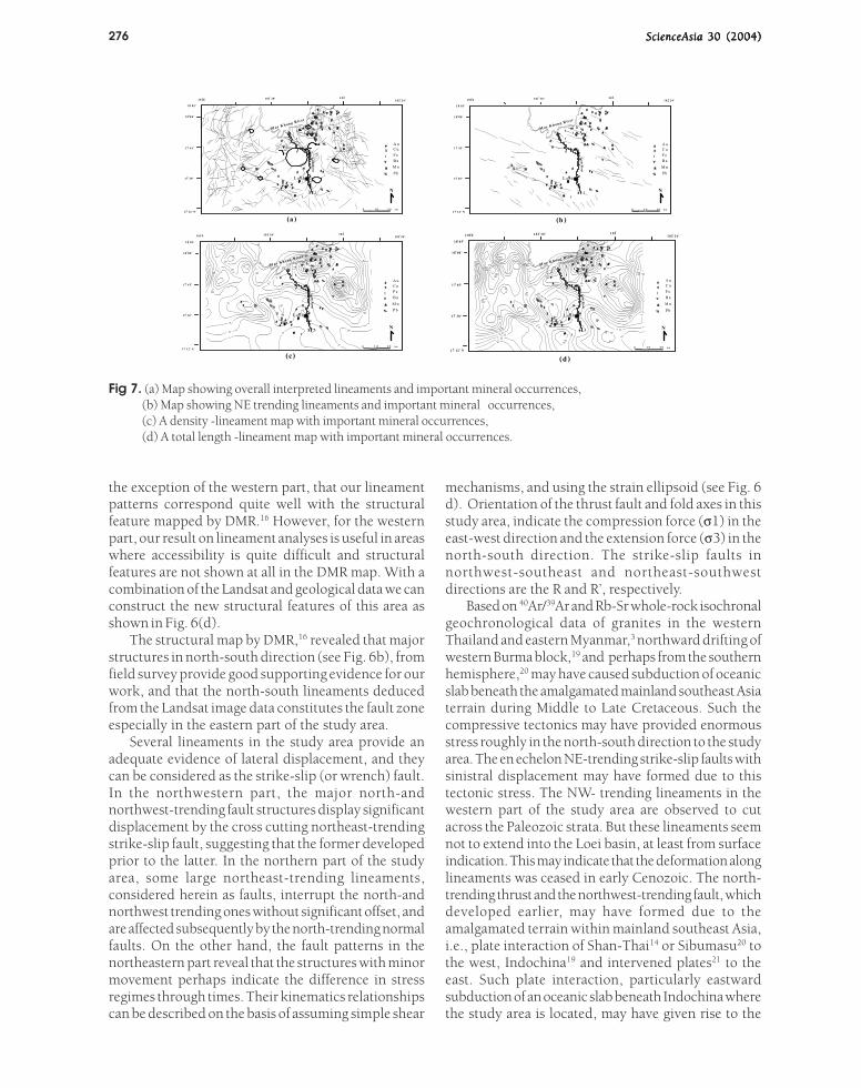
Fig 7. (a) Map showing overall interpreted lineaments and important mineral occurrences,(b) Map showing NE trending lineaments and important mineral occurrences,(c) A density -lineament map with important mineral occurrences,(d) A total length -lineament map with important mineral occurrences.

ScienceAsia ScienceAsia ScienceAsia ScienceAsia ScienceAsia 30 (2004)30 (2004)30 (2004)30 (2004)30 (2004) 277
emplacement of felsic to intermediate magmas. Theintrusive bodies are clearly detected by previouslydescribed circular features in the study area. The north-trending normal fault in the central part of the studyarea cannot be explained using circular strain ellipsoiddue to its much later development. We, therefore,consider that a major change in tectonic regime mayhave occurred after Cretaceous and this maycorrespond to the India-Asia collision22, which mayhave caused the development of the possibly normalfault-bound basin of the north-trending Loei river valley.
Lineaments Related to Mineral DepositsLineaments Related to Mineral DepositsLineaments Related to Mineral DepositsLineaments Related to Mineral DepositsLineaments Related to Mineral DepositsFig. 7 shows the relationship between mineral
occurrences of northern Loei area and lineaments.Most mineral occurrences (Au, Cu, Fe, Ba, Mn and Pb)are located in the central part of the study area. It isclear that mineral deposits, particularly Cu, Fe and Auare significantly related to circular features northwestof the Loei area as shown in Fig. 7 (a). Circular featuresin Thailand were earlier interpreted to represent graniteintrusions producing abundant cracks.23 Such fractureswere able to serve as channel ways for hydrothermaland mineralizing fluids, as discussed by Sawkins,24
Mitchell & Garson,19 and Hutchison.25 Fig. 7 (b) displaysthe minerals occurrences related to the northeast-southwest short lineaments, which generally arebranches of long northwest-trending lineaments,especially at the lineament intersection. We also countnumbers of lineaments and measure their total lengthwithin each square-grid area of 10*10 km using theMapInfo and GEOSOFT programs and present them asdensity and total-length lineament maps as shown inFigs. 7(c) and 7(d), respectively. It can be assumed that,most of mineral occurrences are concentrated in areaswhere lineaments denote both high density andcontinuous total length.
On the bases of these relationships, it appears thatthe northeast-trending lineaments may serve to controlore mineralization. For further exploration we shouldselect targets along this direction starting at prominentintersection, and attention should be focused in areaswith high density and total length of lineaments, suchas an area to the northwest corner of the map (e.g.,further to Laos and nearby area).
CONCLUSIONS
Digital image enhancement processing is a usefultool to help analyzing space-borne image data.Interpretation of images is a qualitative technique andshould be tested against other data such as the airbornegeophysical data, air-photo data and ground-truth fieldchecks.
Combination of major lineaments from enhanced
Landsat data and structures from this and previousgeological maps can delineate new structural featuresof the area. Based upon our lineament analysis, thesuitable area for further mineral exploration can beselected.
ACKNOWLEDGEMENTS
We thank V. Daorerk, head of Department ofGeology Chulalongkorn University and J. Tulatid, asenior geophysicist, Economic Geology Division,Department of Mineral Resources (DMR), for theirfruitful discussion on previous field and remote-sensinginformation, respectively. K. Neawsuparp thanks S.Pothisat, the Director General of DMR, for hisencouragement and permission to publish this result.Thailand Remote Sensing Center, National ResearchCouncil of Thailand (NRC Bangkok) provide all theLandsat data. Parts of this project are sponsored byNRCT, Thailand Research Fund (TRF grant no. PHD/0017/2545), and DMR research fund.
REFERENCES
1. Bunopas S (1981) Paleogeographic history of westernThailand and adjacent part of Southeast Asia-a plate tectonicinterpretation. Ph.D. thesis, Victoria University of Wellington,New Zealand, 810 p.
2. Bunopas S (1988) Summary of Geology of Loei Area andAccompanying 1:100,000 Geological map. MineralResources Development Project, Department of MineralResources, Thailand, 61 p.
3. Charusiri P (1989) Lithophile Metallogenetic Epochs ofThailand: A Geological and Geochonological Investigation.Ph. D Thesis, Queen’s University, Canada, 819 p.
4. Chairangsee C, Hinze C, Machareonsap S, Nakornsri N,Silpalit N and Sinpool- Anunt S (1990) Geological Map ofThailand 1:50,000: Explanation for the sheets Amphoe PakChom 5345 II, Ban Na Kha 5344 I, Ban Huai Khop 5445 II,King Amphoe Nam Som 5444 IV. Hanover: GeologisuhesJahrbuch, Reihe B, 55 p.
5. Jacobson H.S, Pierson C.T, Danusawad T, Japakaset T,Inthuputi B, Siriratanamomgkol C, Prapassornkul S andPholphan N (1969) Mineral Investigations in NorthernThailand. Geological Survey Professional Paper 618,Washington, D.C, 96 p.
6. Jantaranipa W, Vongpromek R, Sukko T. and Preammanee J(1981) Application of Enhanced Landsat to MineralResources of Loei Province, Northeastern Thailand.Economic Geology Bulletin No.30, Economic GeologyDivision, Department of Mineral Resources, Bangkok,Thailand, 40 p.
7. Abrams MJ, Rothery DA and Pontual A (1988) Mapping inthe Oman ophiolite using enhanced Landsat ThematicMapper images. Tectonophysics, 151151151151151:387-401
8. Crosta AP and Moore JMcM (1989) Geological mappingusing Landsat Thematic Mapper imagery in AlmeriaProvince, south-east Spain. International Journal of RemoteSensing, 10(10(10(10(10(3): 505-514.
9. Drury SA (1993) Image interpretation in geology. 2ndedition,Chapman & Hall, London, 283p.

278 ScienceAsia ScienceAsia ScienceAsia ScienceAsia ScienceAsia 30 (2004)30 (2004)30 (2004)30 (2004)30 (2004)
10. Charusiri P, Charusiri B, Pongsapich W andSuwanwerakamtorn R (1993) Application of enhancedsatellite-borne images to the relationship between fracturesand mineralization in Nam Mae Moei-Nam Mae Ping area,
northern Thailand. Nonrenewable Resource, 22222:45-59.11. Mineral Resources Development Project. (1988) Geology
of Loei area. Geological Compilation and Editing Section,Geological Research and Technology Geological SurveyDivision, Bangkok, Department of Mineral Resources,Thailand, 61 p.
12. Sashida K, Igo H, Hisada K, Nakornsri N andAmphornmaha A (1993)Occurrence of Paleozoic and EarlyMesozoic Radiolaria in Thailand (Preliminary Report).Journal of Southeast Asian Earth Sciences, 8:97-108.
13. Intasopa S and Dunn T (1993) Petrology and Srn-Ndisotropic systems of the basalts and rhyolites, Loei. Thailand.Journal of Southeast Asian Earth Sciences, 99999:167-80.
14. Bunopas S (1991) The pre-late Triassic collision and beltsof Shan-Thai and Indochina Microcontinents in Thailand.Proceedings of the papers presented at the first InternationalSymposium of the IGCP Project 321, Gondwana: Dispersaland Accretion of Asia, Kunming, China, 25-30 November,1991.
15. Neawsuparp K (1997) Image processing of Landsat TM andintegration with aeromagnetic data for the structuralinterpretation of Nan suture zone. A Conference on“Geophysics in Prospect ion for Natural ResourcesEngineering and Environmental Problems”, 31 March-1April, organized by Prince of Songkhla University, Songkhla,pp. 139-48.
16. Department of Mineral Resources (DMR) (1992) Commentaryon the Geological Map of Thailand 1:250,000. Bangkok,Thailand, 19 p.
17. Nakapadungrat S and Putthapiban P (1992) Granites andassociated mineralization in Thailand. National conferenceon Geologic Resources of Thailand: Potential for FutureDevelopment, Department of Mineral Resources, Bangkok,Thailand, 17-24 November 1992.
18. Katz M (1980 Lineament analysis of Landsat imagery appliedto mineral exploration. in Laming, D.J.C., and Gibbs, A.K.(eds.) Hidden weath: Mineral exploration techniques intropical forest areas: Geosciences in InternationalDevelopment, AGID Report No.77777, pp.157-66
19. Mitchell AGH and Garson MS (1981) Mineral Deposits andGlobal Tectonic Settings. Academic Press Inc. (London) Ltd.London, 405 p.
20. Metcafe I (1995) Gonwand Disperson and Asian accretion.In Proceedings of the IGCP Symposium of Geology of SEAsi, Hanoi, 1995, pp. 233-66.
21. Charusiri P, Kosuwan S and Imsamut S (1997) TectonicEvolution of Thailand: From Bunopas (1981)’s to a newscenario. In Dheeradilok, P. (ed. in chief), Proceedings ofthe International Conference on Stratigraphy and TectonicEvolution of SE Asia and the Soulth Pacific, Department ofMineral Resources, Bangkok, Thailand, 19-24 August 1997,pp. 414-20
22. Leigh H, Royden, and B. Clark Burchfiel (1997) The TibetanPlateau and Surrounding Region. An Introduction toStructural Geology and Tectonic, McGraw-Hill, Quebec,pp.146-423
23. Charusiri P, Chonglakmani C, Daorek V, Supananthi Sand Imsamut S ( 1994) Detailed Stratigarphy of the BanThasi, Lampang, Northern Thailand: Implications forPaleoenvironments and Tectonic History. In. P. Angsuwathana,T. Wongwanich, W. Tansathien, S.Wongsomsak, and J.Tulayatid (eds.), Proceedings of the International Symposium
on Stratigraphic Correlation of Southeast Asia, IGCP 306,15-20 November 1994, Asia Hotel, Bangkok, pp. 226-4,
24. Sawkins FJ (1976) Massive Sulfide Deposits in Relation toGeotectonics, Metellogeny and Plate Tectonics. GeologicalAssociation of Canada. Special papers 14, pp. 221-40.
25. Hutchison CS (1989) Geological Evolution of Southeast Asia.Oxford Monographs on Geological and Geophysics 13, p.368