LANCASTER CORRIDOR REDEVELOPMENT ROSEDALE STREET REDESIGN ...€¦ · LANCASTER CORRIDOR...
36
LANCASTER CORRIDOR REDEVELOPMENT ROSEDALE STREET REDESIGN PEACH STREET RAILROAD CROSSINGS Presented at the SEE Development Excellence Workshop By Councilmember Wendy Davis, City of Fort Worth March 24, 2004
Transcript of LANCASTER CORRIDOR REDEVELOPMENT ROSEDALE STREET REDESIGN ...€¦ · LANCASTER CORRIDOR...

LANCASTER CORRIDOR REDEVELOPMENTROSEDALE STREET REDESIGN
PEACH STREET RAILROAD CROSSINGS
Presented at theSEE Development Excellence Workshop
ByCouncilmember Wendy Davis, City of Fort Worth
March 24, 2004
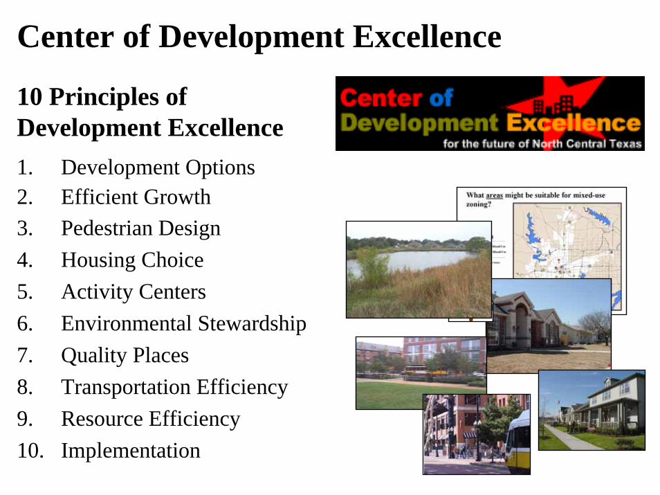
Center of Development Excellence
10 Principles of Development Excellence1. Development Options 2. Efficient Growth3. Pedestrian Design4. Housing Choice5. Activity Centers6. Environmental Stewardship7. Quality Places8. Transportation Efficiency9. Resource Efficiency10. Implementation
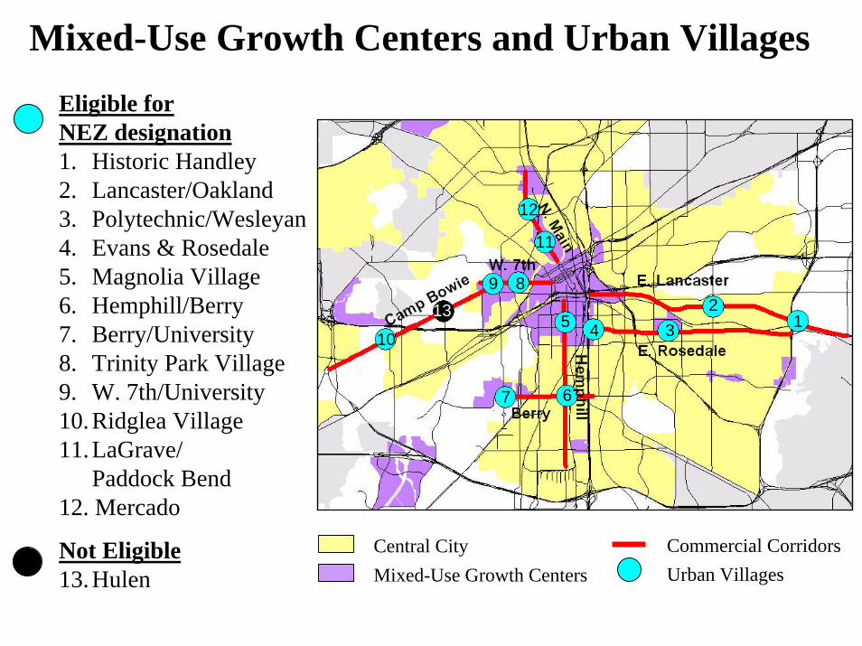
Mixed-Use Growth Centers and Urban VillagesEligible for NEZ designation1. Historic Handley2. Lancaster/Oakland3. Polytechnic/Wesleyan4. Evans & Rosedale5. Magnolia Village6. Hemphill/Berry7. Berry/University8. Trinity Park Village9. W. 7th/University10.Ridglea Village11.LaGrave/
Paddock Bend12. Mercado
Not Eligible13.Hulen
12
345
67
11
12
89
10
13
Commercial CorridorsCentral CityUrban VillagesMixed-Use Growth Centers
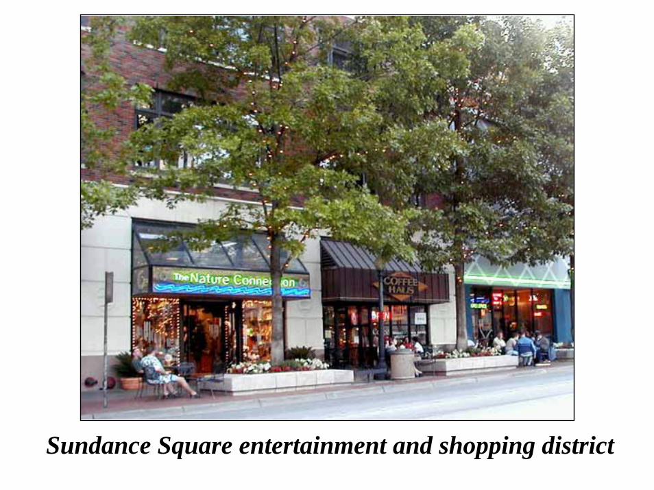
Sundance Square entertainment and shopping district

Sundance Square before reinvestment
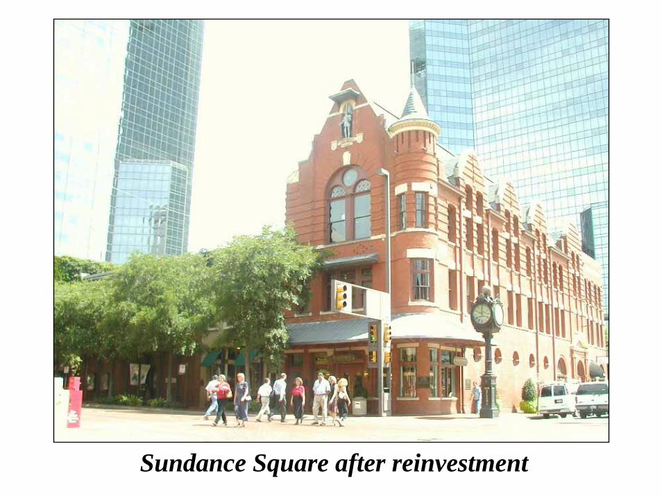
Sundance Square after reinvestment

Lancaster CorridorThe Lancaster Corridor Redevelopment Project is an ambitious effort to revitalize the south end of Downtown.
1. Freeway Relocation2. Lancaster Avenue Redesign3. Hemphill/Lamar/Taylor Connector4. Convention Center Expansion5. Water Gardens Improvements6. Houston/Commerce Two-Way Conversion7. Ramada Plaza Hotel8. Convention Hotel9. Commuter Rail10. ITC11. Rail Market12. Hyde Park13. Ninth Street14. Light Rail Streetcar15. Acquisition of Surplus Property16. TCC Relocation/Expansion17. T&P Terminal18. City Hall Parking Garage19. Vickery TOD site
CompletedSubstantially UnderwayPending Completion of Other Initiatives
3
10
11
4
5 78
13
17
19
15 16
18
12
6
14
1
2
9
Lancaster AveH
ende
rson
W. 9th
Vickery Blvd
CORRIDOR INITIATIVES

FREEWAY RELOCATION1
Before relocation After relocation
The Texas Department of Transportation (TxDOT) has relocated Interstate 30 to the south side of the Union Pacific railroad tracks. The overhead freeway was removed in December of 2001. The $173 million I-30/I-35W reconstruction project was recently completed.

LANCASTER AVENUE REDESIGN2
With the redesign of Lancaster Avenue, the street can be transformed into a great urban place with a lively mix of pedestrian-oriented activities.

116-Foot Cross-Section
23’0” 23’0”
116’0” R.O.W.
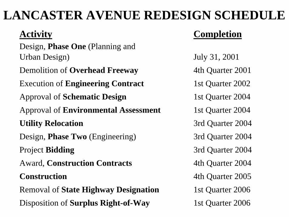
LANCASTER AVENUE REDESIGN SCHEDULEActivity CompletionDesign, Phase One (Planning and Urban Design) July 31, 2001 Demolition of Overhead Freeway 4th Quarter 2001 Execution of Engineering Contract 1st Quarter 2002Approval of Schematic Design 1st Quarter 2004Approval of Environmental Assessment 1st Quarter 2004Utility Relocation 3rd Quarter 2004Design, Phase Two (Engineering) 3rd Quarter 2004 Project Bidding 3rd Quarter 2004 Award, Construction Contracts 4th Quarter 2004Construction 4th Quarter 2005 Removal of State Highway Designation 1st Quarter 2006 Disposition of Surplus Right-of-Way 1st Quarter 2006
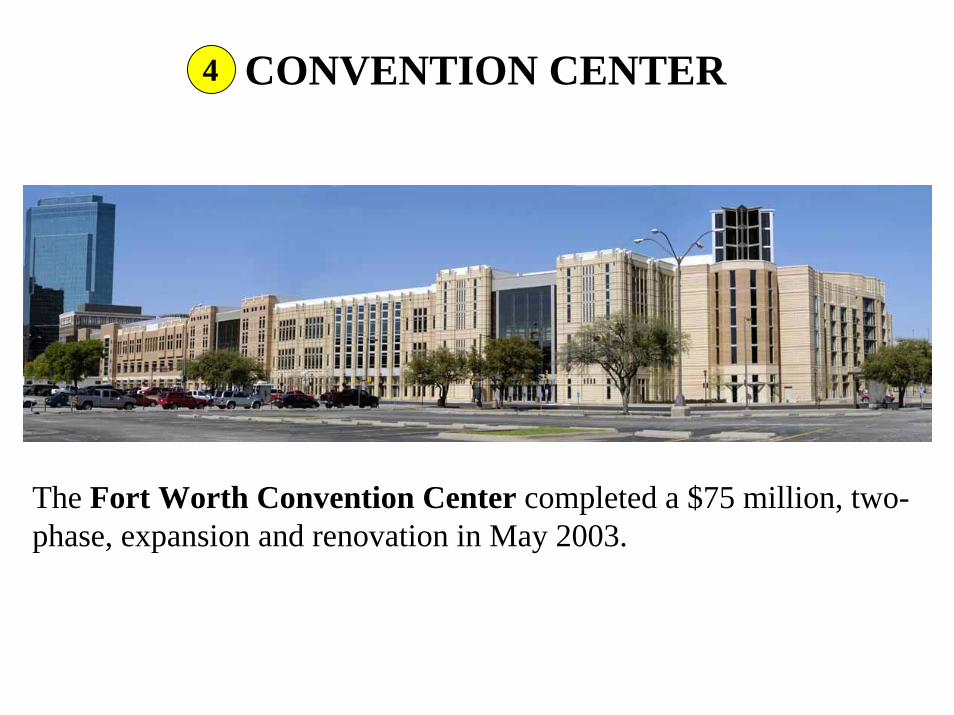
CONVENTION CENTER4
The Fort Worth Convention Center completed a $75 million, two-phase, expansion and renovation in May 2003.
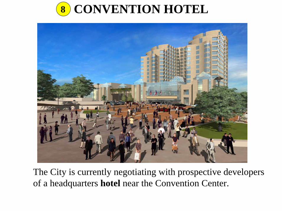
CONVENTION HOTEL8
The City is currently negotiating with prospective developers of a headquarters hotel near the Convention Center.

T&P TERMINAL17
The City expects to execute a development agreement for the redevelopment of the historic Texas and Pacific terminal building as luxury apartments.

ROSEDALE STREET
DowntownDowntown
Fort Worth South
Fort Worth South
Southeast Fort WorthSoutheast Fort Worth
ROSEDALE STREETROSEDALE STREET
I-30I-30 I-35WI-35W
Rosedale Street…• is a principal east-west arterial that serves Fort Worth’s Medical
District (Fort Worth South) and east Fort Worth;• connects to I-30 and I-35W; and• is part of the state highway system maintained by TxDOT.

ROSEDALE STREET IN FORT WORTH SOUTH

PROJECTS IN FORT WORTH SOUTH
Chez Moi TownhomesModern Drug Village
Southside LoftsFairmount Lofts
Oleander WalkSchaumburg Lofts
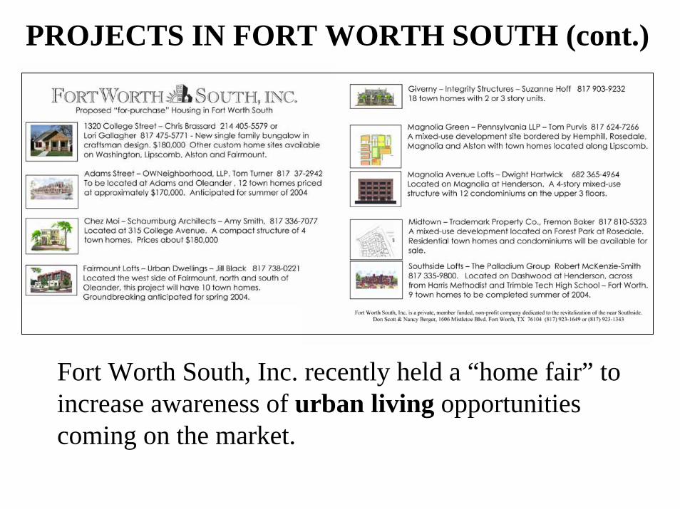
PROJECTS IN FORT WORTH SOUTH (cont.)
Fort Worth South, Inc. recently held a “home fair” to increase awareness of urban living opportunities coming on the market.

MIXED-USE URBAN VILLAGES IMPACTED BY PROPOSED REDESIGN OF ROSEDALE
Magnolia Village Evans And Rosedale Village
ROSEDALE STREETROSEDALE STREET
I-35WI-35W
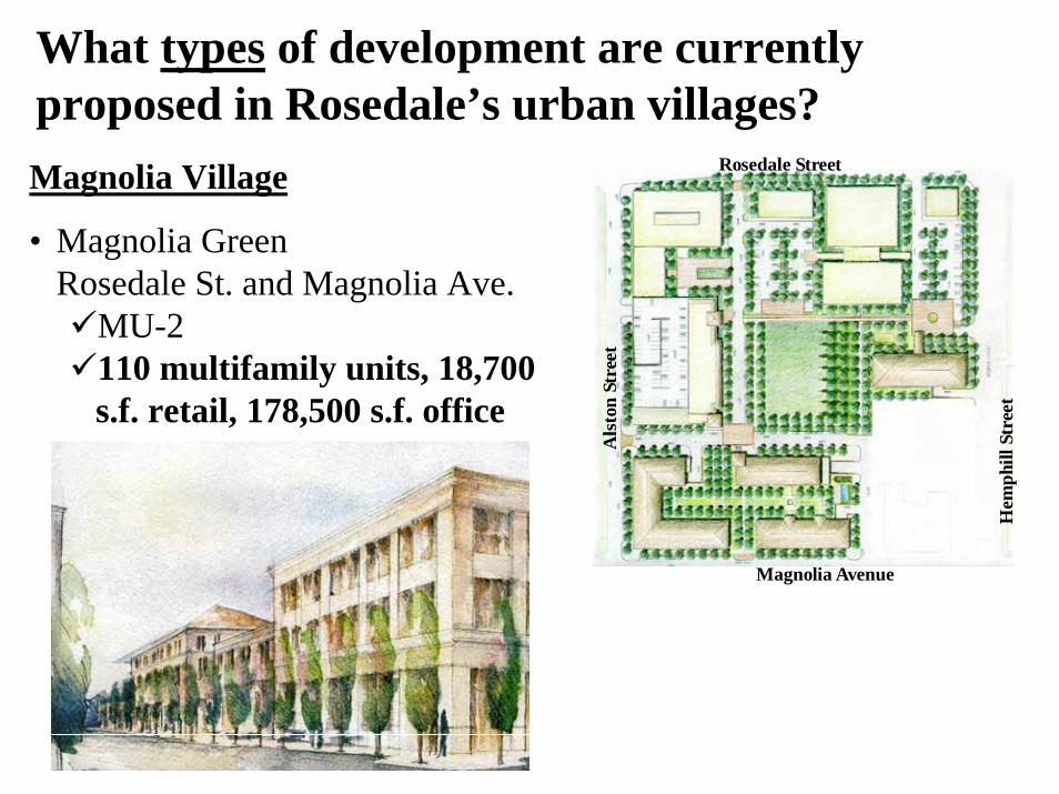
What types of development are currently proposed in Rosedale’s urban villages?Magnolia Village
• Magnolia GreenRosedale St. and Magnolia Ave.
MU-2110 multifamily units, 18,700 s.f. retail, 178,500 s.f. office
Als
ton
Stre
et
Magnolia Avenue
Hem
phill
Str
eet
Rosedale Street

What types of development are currently proposed in Rosedale’s urban villages? (cont.)Evans and Rosedale Village
Conceptual renderings of Evans & Rosedale Village (left). The village centerpiece is the redesigned Evans Avenue (right), with a public plaza (above) celebrating the area’s history and culture.
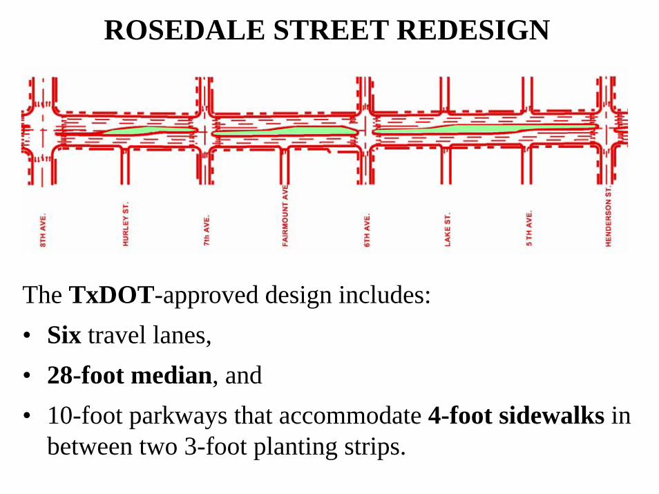
ROSEDALE STREET REDESIGN
The TxDOT-approved design includes:• Six travel lanes, • 28-foot median, and• 10-foot parkways that accommodate 4-foot sidewalks in
between two 3-foot planting strips.
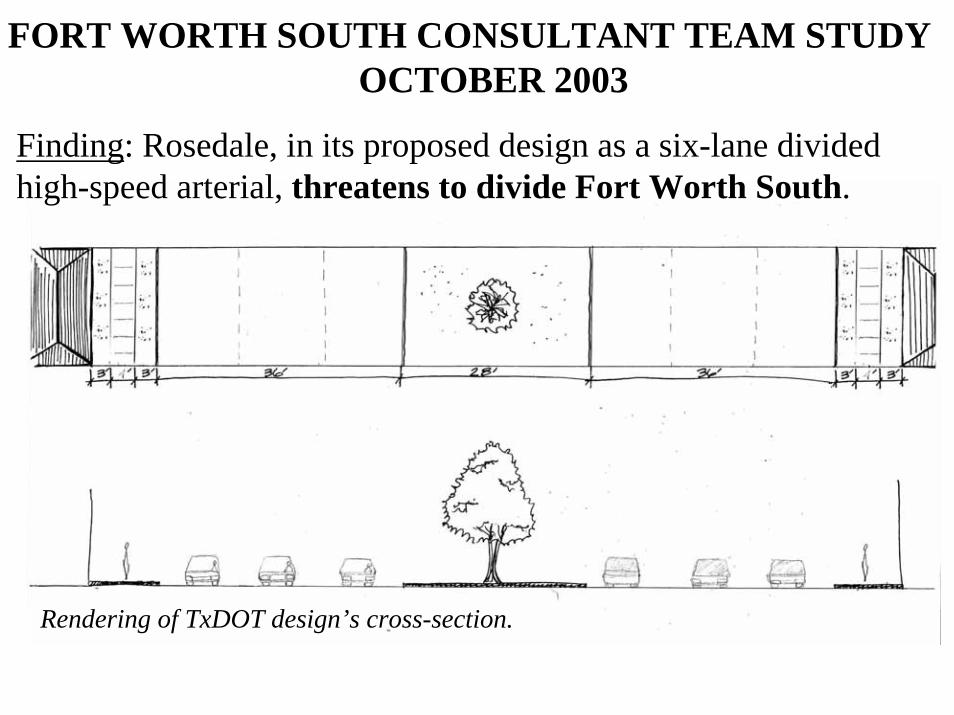
FORT WORTH SOUTH CONSULTANT TEAM STUDY OCTOBER 2003
Finding: Rosedale, in its proposed design as a six-lane divided high-speed arterial, threatens to divide Fort Worth South.
Rendering of TxDOT design’s cross-section.

FORT WORTH SOUTH CONSULTANT TEAM STUDY OCTOBER 2003
Recommendation: Redesign Rosedale as a pedestrian-friendly, landscaped street that unites the district.
Rendering of consultant team’s proposed cross-section.

STATUS OF REDESIGNThe City has been working with TxDOT in analyzing a variety of design options. To minimize the need for budget and schedule adjustments, one option would be to move forward with the six-lane design, leaving open the possibility for future modifications. As additional funding is identified, the City would provide additional landscaping and construct bulb-outs that would allow on-street parking and shorten crossing distances, making the street more pedestrian-oriented.
Rendering of TxDOT design modified to include proposed bulb-outs at intersections.
PEACH STREET AREARAILROAD PROJECT

N
Live Oak
E 1st St
Peach
Gounah
Samuels
GilvinIH
-35W
3rd St
4th StBN/UP
HamptonBluff
BN
SF
2
Peach Street Area Map
RR track
RR crossing
RR underpass
UP
Belknap
Weatherford
1
5
Fire Station
No 1
Pharr
5
4
3
Nash Elem.
The Existing Situation

East 1st Street & BN/UP
• Three major railroad lines go through the neighborhood.
• 60 trains per day.• Trains up to 1 ½ miles long.• Six crossings, some with multiple tracks (one with
nine tracks)
Peach Street & BNSF
The Existing Situation

Safety & Environmental Concerns
• Railroad crossings blocked by stopped or slow-moving trains:– Obstruct cars and children's routes to school.– Delay emergency service response.
• Train horn noise.
East 1st Street & BN/UP

Tower 55 Railroad Interchange:• At-grade rail crossing• 130 EW & NS trains per day• Busiest rail crossing west of the
Mississippi
IH-35W
Note: Mixmaster under construction
North
Convention Center
The Primary Cause

4
5
2
1
3
N
Live Oak
E 1st St
Peach
Gounah
Samuels
Weatherford
GilvinIH
-35W
3rd St
4th St
Belknap
BN
SF
BN/UP
UP
HamptonBluff
XX
FeaturesConstruct Live Oak Connector to 4th St
Close crossing 1 1st St & UPClose crossing 2 1st St & BN/UP
Construct Live Oak ConnectorC
Alternatives
Several alternatives were
discussed with the neighborhood
Solutions

Solutions
• Construct two pedestrian underpasses.• Construct new connector road.• Close unnecessary railroad crossings.• Create a Quiet Zone.
Peach Street & BNSF
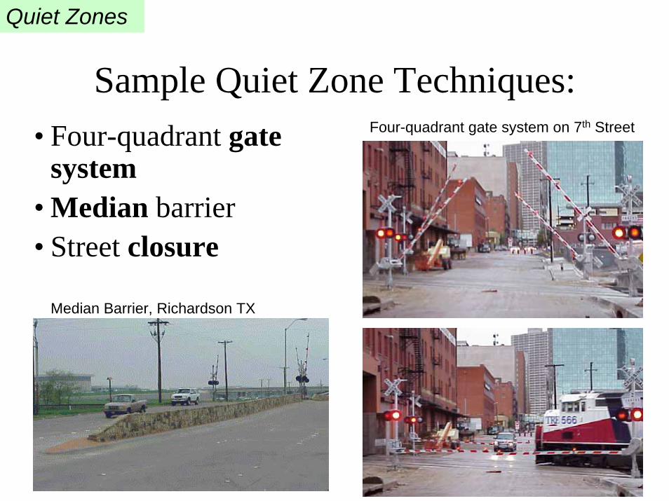
Quiet Zones
Sample Quiet Zone Techniques:• Four-quadrant gate
system• Median barrier• Street closure
Four-quadrant gate system on 7th Street
Median Barrier, Richardson TX

Ongoing Partnerships• Rock Island/Samuels Avenue Neighborhood Association
• Trinity Bluff development
• BNSF Railroad
• Union Pacific Railroad
• Purina Mills
• FBM Trading Co.
• City of Fort Worth, Fire Department
• City of Fort Worth, Transportation and Public Works Department