Geostat Summer School - GitHub Pagesbarryrowlingson.github.io/geostat/geopython.pdf ·...
27
Geostat Summer School 1
Transcript of Geostat Summer School - GitHub Pagesbarryrowlingson.github.io/geostat/geopython.pdf ·...

Geostat Summer School
1

GeoPython
Your Python Starter. . .
Python?
Its easy!
Its like R
Like this:
>>> x = 1>>> y = 4>>> x * y4>>> x + y5
2

Not like this though:
>>> x = [1, 2, 3]>>> y = 3 + xTraceback (most recent call last):
File "<console>", line 1, in <module>TypeError: unsupported operand type(s) for +: 'int' and 'list'
Like this:
>>> x = [1, 2, 3]>>> y = [3 + z for z in x]>>> y[4, 5, 6]
Functions
def
• Define functions:
>>> def poly(x, a, b, c):... y = [a * z**2 + b * z + c for z in x]... return y...
• Call functions:
>>> poly([1,2,3], 2,-1,3)[4, 9, 18]>>>>>> poly([1,2,3], a=2, b=-1, c=3)[4, 9, 18]>>>>>> poly([1,2,3], c=2, b=-1, 3)
File "<console>", line 1SyntaxError: non-keyword arg after keyword arg>>>>>> poly([1,2,3], 2, b=-1, c=3)[4, 9, 18]
3

Args
Defaults etc. . .
>>> def foo(myparameter=99):... return myparameter*2...>>> foo()198>>> foo(100)200>>> foo(myp=100)Traceback (most recent call last):
File "<console>", line 1, in <module>TypeError: foo() got an unexpected keyword argument 'myp'>>> foo(myparameter=100)200>>> foo(myparameterandabit=100)Traceback (most recent call last):
File "<console>", line 1, in <module>TypeError: foo() got an unexpected keyword argument 'myparameterandabit'
Loops
for loops
>>> word = ["B", "A", "R", "R", "Y"]>>> for letter in word:... print letter...BARRY
Nested
Loops in loops
>>> n = len(word)>>> for ia in range(0,n):
4

... a = word[ia]
... for ib in range(ia+1, n):
... b = word[ib]
... print a,b
...B AB RB RB YA RA RA YR RR YR Y
That’s a fairly common pattern, we’ve cluttered it up. All we really want to dois:
for (a,b) in pairs(word):print a,b
Generators
Advanced stuff made easy
>>> def pairs(v):... n = len(v)... for i in range(0,n):... a = v[i]... for j in range(i+1, n):... b=v[j]... yield (a,b)...>>> for (a,b) in pairs(word):... print a,b...B AB RB RB YA RA R
5

A YR RR YR Y
imports
get code from files
## this is samples.py in my working directory#def bar(x):
return x*2
def baz(x):return x*3
>>> import samples>>> samples.bar(99)198>>>>>> from samples import baz>>> baz(100)300>>>>>> # if I edit samples.py....>>>>>> reload(samples)<module 'samples' from '/home/rowlings/Work/Teaching/GeostatSummerSchool/2014/Site/geostat/samples.pyc'>
Library Modules
Get installed module code
>>> import os>>> os.path.realpath(".")'/home/rowlings/Work/Teaching/GeostatSummerSchool/2014/Site/geostat'>>> os.path.join("foo","bar","baz")'foo/bar/baz'>>> os.uname()('Linux', 'barry-OptiPlex-755', '3.8.0-31-generic', '#46-Ubuntu SMP Tue Sep 10 20:03:44 UTC 2013', 'x86_64')
6

Python comes with a complete standard library. R didn’t have a full file namehandling package until 2014 (the pathological package on github).
Help!
How to get help
>>> help(os.uname)Help on built-in function uname in module posix:
uname(...)uname() -> (sysname, nodename, release, version, machine)
Return a tuple identifying the current operating system.
Unlike R, you can get help from objects!
Methods
What can I do with X?
>>> x="hello world">>> dir(x)['__add__', '__class__', '__contains__', '__delattr__', '__doc__', '__eq__', '__format__', '__ge__', '__getattribute__', '__getitem__', '__getnewargs__', '__getslice__', '__gt__', '__hash__', '__init__', '__le__', '__len__', '__lt__', '__mod__', '__mul__', '__ne__', '__new__', '__reduce__', '__reduce_ex__', '__repr__', '__rmod__', '__rmul__', '__setattr__', '__sizeof__', '__str__', '__subclasshook__', '_formatter_field_name_split', '_formatter_parser', 'capitalize', 'center', 'count', 'decode', 'encode', 'endswith', 'expandtabs', 'find', 'format', 'index', 'isalnum', 'isalpha', 'isdigit', 'islower', 'isspace', 'istitle', 'isupper', 'join', 'ljust', 'lower', 'lstrip', 'partition', 'replace', 'rfind', 'rindex', 'rjust', 'rpartition', 'rsplit', 'rstrip', 'split', 'splitlines', 'startswith', 'strip', 'swapcase', 'title', 'translate', 'upper', 'zfill']>>> x.title()'Hello World'>>> x.upper()'HELLO WORLD'>>> x.split()['hello', 'world']>>> help(x.split)Help on built-in function split:
split(...)S.split([sep [,maxsplit]]) -> list of strings
Return a list of the words in the string S, using sep as thedelimiter string. If maxsplit is given, at most maxsplitsplits are done. If sep is not specified or is None, anywhitespace string is a separator and empty strings are removedfrom the result.
7

Python Objects
Lots of things are objects
• x = "hello world" creates an object x
• x.split() runs the split “method” on x , returns a list. xdoesn’t change. . .
• but methods can change the object they run on.
>>> z = [9,6,2,3]>>> z.sort()>>> z[2, 3, 6, 9]
• They can return a value and change the object:
>>> last = z.pop()>>> last9>>> z[2, 3, 6]
A sample class
Point object
>>> class Point(object):... def __init__(self,x,y):... self.x = x... self.y = y... def coord(self):... return [self.x, self.y]... def shift(self, dx, dy):... self.x = self.x + dx... self.y = self.y + dy...>>> p = Point(2.4, 4.5)>>>>>> p.x2.4>>>>>> p.coord()
8

[2.4, 4.5]>>>>>> p.shift(1000,2000)>>> p.coord()[1002.4, 2004.5]>>>
Distance
Pythagoras
>>> import math>>> def pythagoras(p0, p1):... return math.sqrt((p1.x-p0.x)**2 + (p1.y-p0.y)**2)...>>> pythagoras(Point(0,0),Point(3,4))5.0
Sphere Distance
Spherical Distance
>>> # From: https://gist.github.com/gabesmed/1826175>>>>>> EARTH_RADIUS = 6378137 # radius in metres>>>>>> points = [... Point(40.750307,-73.994819),... Point(40.749641,-73.99527)... ]>>>>>> def great_circle_distance(latlong_a, latlong_b):... lat1, lon1 = latlong_a.coord()... lat2, lon2 = latlong_b.coord()...... dLat = math.radians(lat2 - lat1)... dLon = math.radians(lon2 - lon1)... a = (math.sin(dLat / 2) * math.sin(dLat / 2) +... math.cos(math.radians(lat1)) * math.cos(math.radians(lat2)) *... math.sin(dLon / 2) * math.sin(dLon / 2))... c = 2 * math.atan2(math.sqrt(a), math.sqrt(1 - a))... d = EARTH_RADIUS * c
9

...
... return d
...>>> great_circle_distance(points[0], points[1])83.32536285505579
Ellipses?
Vincenty’s Formula (wikipedia)
Part one. . .
Serious numbers
Use numpy for maths
>>> import numpy as np>>> [math.sin(x) for x in [1,2,3]][0.8414709848078965, 0.9092974268256817, 0.1411200080598672]>>> np.sin([1,2,3])array([ 0.84147098, 0.90929743, 0.14112001])>>> np.random.poisson(10,20)array([11, 12, 10, 8, 13, 11, 14, 10, 10, 13, 7, 15, 8, 12, 10, 10, 8,
6, 11, 11])
>>> m = np.matrix([[1,2], [3,4]])>>> m
10

matrix([[1, 2],[3, 4]])
>>> m * mmatrix([[ 7, 10],
[15, 22]])>>> m * m.transpose()matrix([[ 5, 11],
[11, 25]])>>> m * m.Imatrix([[ 1.00000000e+00, 0.00000000e+00],
[ 8.88178420e-16, 1.00000000e+00]])
External Libraries
Geopy
>>> import geopy>>> from geopy.distance import great_circle>>>>>> d = great_circle(points[0].coord(), points[1].coord())>>> dDistance(0.0832555738102)>>> help(d)Help on great_circle in module geopy.distance object:
class great_circle(Distance)| Use spherical geometry to calculate the surface distance between two| geodesic points. This formula can be written many different ways,| including just the use of the spherical law of cosines or the haversine| formula.|| Set which radius of the earth to use by specifying a 'radius' keyword| argument. It must be in kilometers. The default is to use the module| constant `EARTH_RADIUS`, which uses the average great-circle radius.|| Example::|| >>> from geopy.distance import great_circle| >>> newport_ri = (41.49008, -71.312796)| >>> cleveland_oh = (41.499498, -81.695391)| >>> great_circle(newport_ri, cleveland_oh).miles| 537.1485284062816|| Method resolution order:
11

| great_circle| Distance| __builtin__.object|| Methods defined here:|| __init__(self, *args, **kwargs)|| destination(self, point, bearing, distance=None)| TODO docs.|| measure(self, a, b)|| ----------------------------------------------------------------------| Methods inherited from Distance:|| __abs__(self)|| __add__(self, other)|| __bool__ = __nonzero__(self)|| __cmp__(self, other)|| __div__(self, other)|| __mul__(self, other)|| __neg__(self)|| __nonzero__(self)|| __repr__(self)|| __str__(self)|| __sub__(self, other)|| __truediv__ = __div__(self, other)|| ----------------------------------------------------------------------| Data descriptors inherited from Distance:|| __dict__| dictionary for instance variables (if defined)|
12

| __weakref__| list of weak references to the object (if defined)|| feet|| ft|| kilometers|| km|| m|| meters|| mi|| miles|| nautical|| nm
>>>>>> d.meters83.255573810242>>>>>> d.feet273.1482079345222>>>>>> geopy.distance.EARTH_RADIUS = EARTH_RADIUS/1000>>> great_circle(points[0].coord(), points[1].coord()).meters83.32357305730429
geopy again
Vincenty distance
>>> from geopy.distance import vincenty>>> great_circle(points[0].coord(), points[1].coord()).m83.32357305730429>>> vincenty(points[0].coord(), points[1].coord()).m83.19003856394464
13

More geopy magic
geocoding
>>> from geopy.geocoders import osm>>> g = osm.Nominatim(timeout=10)>>> home = g.geocode("Lancaster, UK")>>> away = g.geocode("Bergen")>>> vincenty(home.point, away.point).miles532.7862059372253>>> vincenty(home.point, away.point).km857.4362841353374
fiona
Read data with fiona
>>> import fiona>>> england = fiona.open("./data/England/engos.shp","r")>>> england.meta{'crs': {u'lon_0': -2, u'k': 0.9996012717, u'datum': u'OSGB36', u'y_0': -100000, u'no_defs': True, u'proj': u'tmerc', u'x_0': 400000, u'units': u'm', u'lat_0': 49}, 'driver': u'ESRI Shapefile', 'schema': {'geometry': 'Polygon', 'properties': OrderedDict([(u'ADMIN_NAME', 'str:16'), (u'AREA', 'float:12.3'), (u'PERIMETER', 'float:12.3'), (u'ADMIN2_', 'float:11'), (u'ADMIN2_ID', 'float:11'), (u'GMI_ADMIN2', 'str:16'), (u'COUNTRY', 'str:16')])}}>>> england.meta['crs']{u'lon_0': -2, u'k': 0.9996012717, u'datum': u'OSGB36', u'y_0': -100000, u'no_defs': True, u'proj': u'tmerc', u'x_0': 400000, u'units': u'm', u'lat_0': 49}>>> england.meta['schema']['properties']OrderedDict([(u'ADMIN_NAME', 'str:16'), (u'AREA', 'float:12.3'), (u'PERIMETER', 'float:12.3'), (u'ADMIN2_', 'float:11'), (u'ADMIN2_ID', 'float:11'), (u'GMI_ADMIN2', 'str:16'), (u'COUNTRY', 'str:16')])
features
get the features
>>> features = list(england)>>> features[31]['properties']OrderedDict([(u'ADMIN_NAME', u'Greater London'), (u'AREA', 0.208), (u'PERIMETER', 2.344), (u'ADMIN2_', 68.0), (u'ADMIN2_ID', 68.0), (u'GMI_ADMIN2', u'GBR-ENG-GLN'), (u'COUNTRY', u'England')])>>> features[32]['geometry'].keys()['type', 'coordinates']>>> features[32]['geometry']['type']'Polygon'>>> features[32]['geometry']['coordinates'][0][:10][(331218.2373748748, 158030.96091701294), (331552.45641719806, 159850.56801485896), (331184.5610176229, 161275.67909807622), (332744.8749578969, 162213.8018719227), (333147.93532494607, 163443.23593871036), (333276.9293876288, 164430.18301096238), (332605.5811962088, 164841.68800689976), (332557.7609554768, 165614.56502538442), (333861.26445889025, 166247.08819716435), (335210.2781934715, 165920.42688398046)]
14

processing with shapely
example
>>> from shapely.geometry import mapping, shape>>>>>> import fiona>>>>>> input_shp = "./data/England/engos.shp">>> output_shp = "./data/England/buffered.shp">>> width = 10000>>>>>> def bufferinout(input_shp, output_shp, width):... input = fiona.open(input_shp, "r")... schema = { 'geometry': 'Polygon', 'properties': { 'name': 'str' } }... output = fiona.open(output_shp, "w", "ESRI Shapefile", schema, crs = input.crs)... for feature in input:... output.write({... 'properties': {... 'name': feature['properties']['ADMIN_NAME']... },... 'geometry': mapping(shape(feature['geometry']).buffer(width))... })...>>> bufferinout(input_shp, output_shp, width)
Scripting
Command-line scripts
With this in buffering.py for example:
import sys
import fiona
def bufferinout(input, output, width):" compute the buffer... "....
if __name__=="__main__":input = sys.argv[1]
15
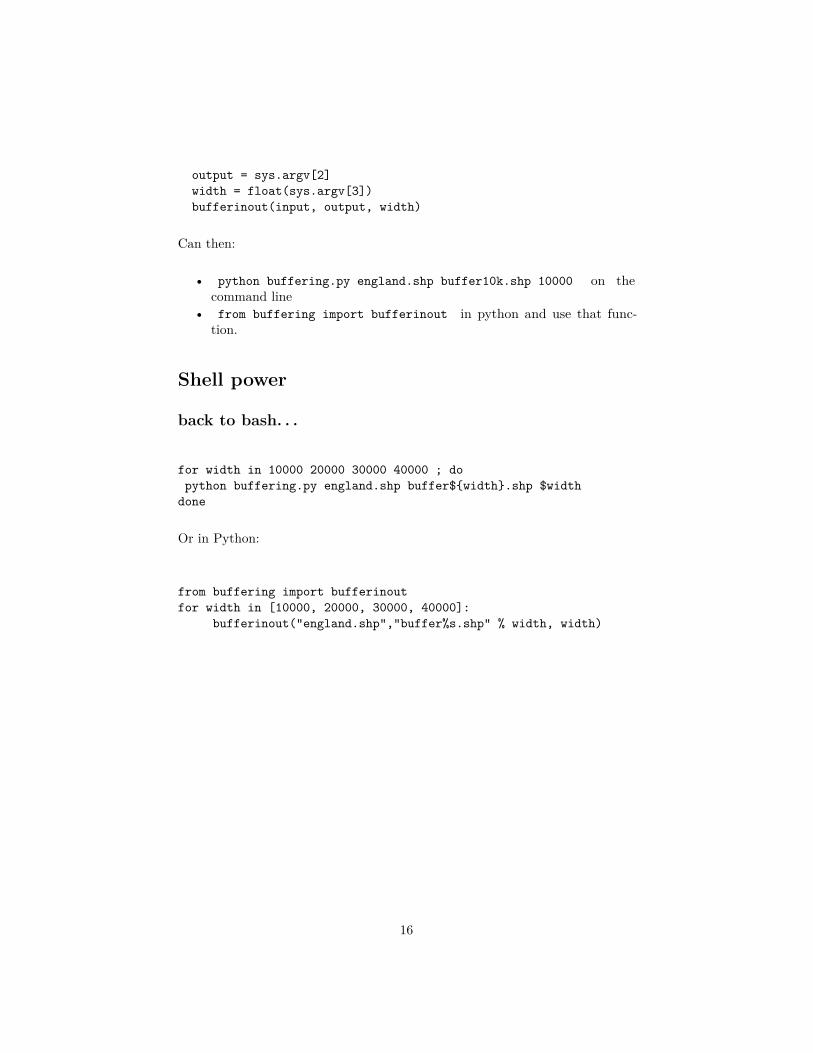
output = sys.argv[2]width = float(sys.argv[3])bufferinout(input, output, width)
Can then:
• python buffering.py england.shp buffer10k.shp 10000 on thecommand line
• from buffering import bufferinout in python and use that func-tion.
Shell power
back to bash. . .
for width in 10000 20000 30000 40000 ; dopython buffering.py england.shp buffer${width}.shp $width
done
Or in Python:
from buffering import bufferinoutfor width in [10000, 20000, 30000, 40000]:
bufferinout("england.shp","buffer%s.shp" % width, width)
16
Geopandas
The future
Geopandas
Like Spatial Data Frames
>>> import geopandas as gpd>>> africa = gpd.read_file("./data/Africa/africa.shp")>>> africa[:5]
CNTRY_NAME COUNT FIRST_CONT FIRST_FIPS FIRST_REGI SUM_POP_AD \0 Algeria 48 Africa AG Northern Africa 342225701 Angola 18 Africa AO Middle Africa 11527258
17

2 Benin 6 Africa BN Western Africa 51753943 Botswana 10 Africa BC Southern Africa 11852504 Burkina Faso 30 Africa UV Western Africa 10817069
SUM_SQKM_A SUM_SQMI_A geometry0 2320972.339 896127.445 POLYGON ((2.963609933853149 36.80221557617188,...1 1252420.770 483559.643 (POLYGON ((11.77499961853027 -16.8047256469726...2 116514.769 44986.354 POLYGON ((2.484417915344238 6.340485572814941,...3 580011.123 223942.302 POLYGON ((26.16782760620117 -24.66396713256836...4 273719.207 105682.987 POLYGON ((-1.003023386001587 14.8400993347168,...
[5 rows x 9 columns]
plotting
plot method
>>> import matplotlib.pyplot as plt>>> fig = africa.plot(column="SUM_POP_AD")>>> plt.show()>>> plt.cla()>>> fig = africa.plot(column="FIRST_REGI",legend=True)>>> plt.show()
18

19

Buffering Geopandas
GeoPandas methods for geometry
>>> from geopandas import GeoSeries>>> england = gpd.read_file("./data/England/engos.shp")>>> fig = england.plot()>>> plt.show()>>> plt.cla()>>> coast = GeoSeries(england.geometry.unary_union)>>> coastal_buffer = GeoSeries(coast.buffer(20000))>>> fig = coastal_buffer.plot()>>> fig = coast.plot()>>> plt.show()
20

21

JS Mapping
Packages
• mplleaflet
import mplleafletniger = gpd.read_file("./data/Africa/niger.shp")niger.plot()# write an HTML file and show in browsermplleaflet.show()
• folium
# convert to geoJSON fileopen("niger.json","w").write(niger.to_json())
map_osm = folium.Map(location=[17,10])
# add map to outputmap_osm.geo_json("./niger.json", data=niger,
columns=['ADM2','POP'], key_on='feature.properties.ADM2',fill_color='YlGn', fill_opacity=0.7, line_opacity=0.2,legend_name="Fake Population")
# create and view in browsermap_osm.create_map("niger.html")
22

Leaflet map
From folium
23

ipython
notebooks
pysal
Local Moran calculation
>>> import geopandas as gpd>>> import numpy as np>>> import pysal>>> shapefile = "data/NewYork/NY8_utm18.shp">>> galfile = "data/NewYork/NY_nb.gal">>> spdf = gpd.read_file(shapefile)>>>>>> y = np.array(spdf['Cases'])>>> w = pysal.open(galfile).read()>>> lm = pysal.Moran_Local(y,w,transformation="V")>>> lm.Is[:5]array([ 0.56778845, 0.70374966, -0.51771761, -0.19487455, -0.17114584])
24

Map
Plot the I values
>>> spdf['I']=lm.Is>>> spdf.plot(column="I")<matplotlib.axes.AxesSubplot object at 0x60dbc10>>>> plt.show()
pysal
Features• esda (moran, geary. . . )
25

• smoothing (empirical bayes. . . )• regression with spatial weights (ols, probit. . . )
Unfeatures• graphics• summaries• documentation?
Rpy2
Fill in the gaps
>>> import rpy2.robjects as robjects>>> from rpy2.robjects.packages import importr>>> spdep = importr("spdep")>>> NY_nb = spdep.read_gal(galfile, region=range(281))>>> lmR = spdep.localmoran(robjects.FloatVector(spdf['Cases']), listw = spdep.nb2listw(NY_nb, style="S"))>>> fig = plt.hist(lmR.rx(True,"Z.Ii"))>>> plt.show()
26

Summary
Stuff you might want to look into. . .• Python• ipython notebooks are cool!• Numpy for numeric matrix/raster ops• Scipy - scientific python• shapely, fiona, rasterio for data and geometry• Geopandas for spatial data• Pysal for spatial statistics• pymc for MCMC calculations (like BUGS)• LOTS of machine learning stuff• Rpy2 when all else fails
27