
GEOLOGICAL REPORT - aris.empr.gov.bc.ca
11
GEOLOGICAL REPORT on the ELM PROPERTY-TENURE #508266 KAMLOOPS M.D. NTS 921/15W LA T 50-58 N LONG 120-52 W by J.D.MURPHY OWNER AND OPERATOR 2010/08/26
Transcript of GEOLOGICAL REPORT - aris.empr.gov.bc.ca

GEOLOGICAL REPORT
on the
ELM PROPERTY-TENURE #508266
KAMLOOPS M.D. NTS 921/15W
LA T 50-58 N LONG 120-52 W
by
J.D.MURPHY
OWNER AND OPERATOR
2010/08/26
ldegroot
Text Box
BC Geological Survey Assessment Report 31638

TABLE OF CONTENTS
Page
INTRODUCTION 1
SUMMARY AND CONCLUSIONS 2
RECOMMENDATIONS 2
FIELD PROCEDURES 2
DISCUSSION OF RESULTS 2
STATEMENT OF COSTS 3
STATEMENT OF QUALIFICATIONS 4
REFERENCES 5
Claim Map
Plate No. 2
LIST OF ILLUSTRATIONS
1
Back Cover

^BRITISH COLUMBIA
Ministry of Energy & Mines Energy & Minerals Division Geological Survey Branch
RECEIVED SEP Q 2 2010
B C Gold Commissioner's Office
Vancouver, B C
ASSESSMENT REPORT TITLE PAGE AND SUMMARY
TITLE OF REPORT [type of survey{s>] TOTAL COST
AUTHORfS> J- t>, tMK WL SIGN ATI) REfS) VL t u
NOTICE OF WORK PERMIT NUMBERfSVDATEfSl fj/k
STATEMENT OF WORK - CASH PAYMENT EVENT NUMBER(S)/DATE(S)_
YEAR OF WORK £0 J O
PROPERTY NAME^ — CLAIM NAME(S) (on vwtiich work was done}_
u2 ?m« COMMODITIES SOUGHT Au , /?] & . Ma.
MINERAL INVENTORY MINFtLE NUMBER(S), IF KNOWN Q£JL1 6 i £j£L t£L
MINING DIVISION K$ML0OPS NTS J2jfIS W LATITUDE a d(3 LONGITUDE / 2Q o Sj
OWNER(S)
1) y , p. Muzpftf 2)
48 (at centre of work)
MAILING ADDRESS
/34S T&Pb
OPERATOR(S) [who paid for the work]
J, P. MU&P/JV 2)
MAILING ADDRESS
MfrMLAPP?,
PROPERTY GEOLOGY KEYWORDS (lithology, age, stratigraphy, structure, alteration, mineralization, size and attitude):
Juro-istt- A skrrc f J~ ttrrnti ft r-^ e e-n j t a m e r a fa . ,
6 U C 4 fg ijl /<? JffockS-
REFERENCES TO PREVIOUS ASSESSMENT WORK AND ASSESSMENT REPORT NUMBERS £2&3jet. ?2943> £3437,
£43&t (OVER)

TYPE OF WORK IN
1 HIS REPORT
EXTENT OF WORK
(IN METRIC UNITS)
_M _J[ \ • _ -•
ON WHICH CLAIMS PROJECT COSTS APPORTIONED (incl. support)
GEOLOGICAL (scale, area)
Ground, mapping ///oca ' 3 h&cJ-Q Z4 9-4 .Zi~
Photo Interpretation
GEOPHYSICAL (line-kilometres)
Ground • "
Magnetic
Electromagnetic
Induced Polarization
Radiometric
Seismic
Other ,
Airborne
G E O C H E M I C A L
(number of samples analysed for...)
Soli
Silt
Rock
Other
DRILLING
(total metres; number of holes, size)
Core
Non-core
RELATED TECHNICAL
Sampling/assaying
Pelrographic
Mineralographic
Metallurgic
PROSPECTING (scale, araa}
PREPARATORY/PHYSICAL
Une/grid (kilometres)
Topographic/Photogrammetric (scale, area)
• •
Legal surveys (scale, area)
Road, local access (kilometres)/trail
Trench (metres) _ _ _ _ _ _ _ _ _ _
Underground dev. (metres)
Other
TOTAL COST
INTRODUCTION
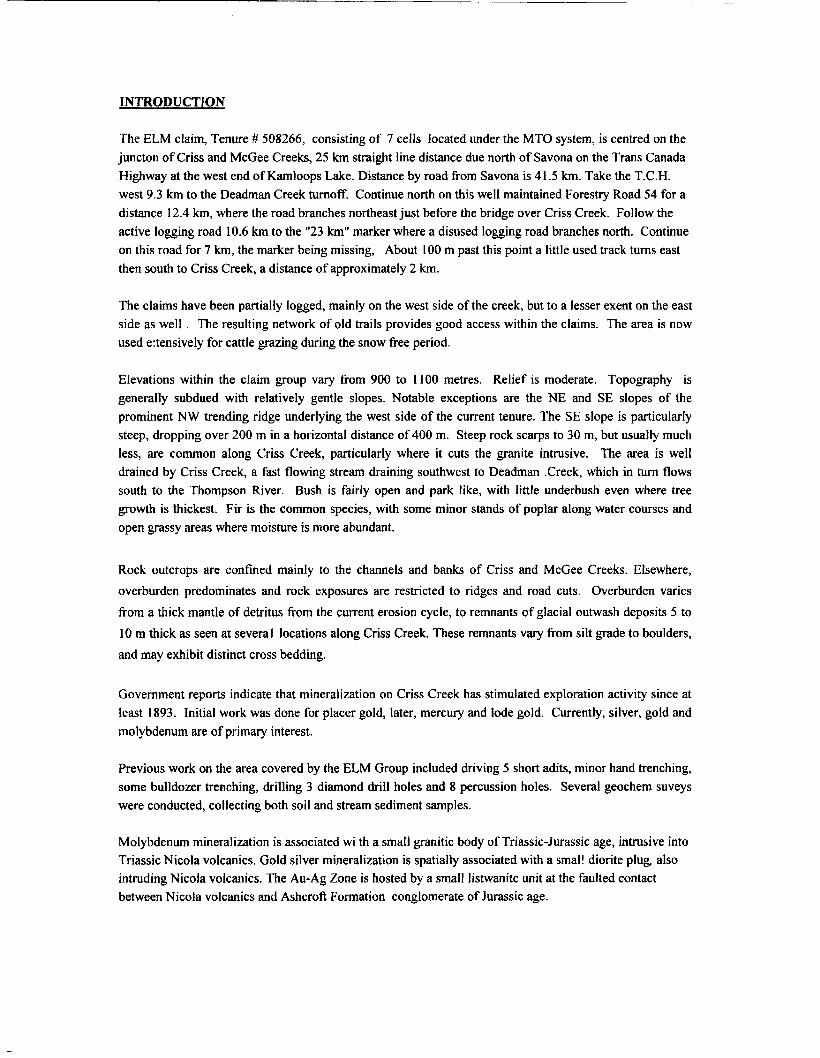
The ELM claim, Tenure # 508266, consisting of 7 cells located under the MTO system, is centred on the juncton of Criss and McGee Creeks, 25 km straight line distance due north of Savona on the Trans Canada Highway at the west end of Kamloops Lake. Distance by road from Savona is 41.5 km. Take the T.C.H. west 9.3 km to the Deadman Creek turnoff. Continue north on this well maintained Forestry Road 54 for a distance 12.4 km, where the road branches northeast just before the bridge over Criss Creek. Follow the active logging road 10.6 km to the "23 km" marker where a disused logging road branches north. Continue on this road for 7 km, the marker being missing, About 100 m past this point a little used track turns east then south to Criss Creek, a distance of approximately 2 km.
The claims have been partially logged, mainly on the west side of the creek, but to a lesser exent on the east side as well . The resulting network of old trails provides good access within the claims. The area is now used e:tensively for cattle grazing during the snow free period.
Elevations within the claim group vary from 900 to 1100 metres. Relief is moderate. Topography is generally subdued with relatively gentle slopes. Notable exceptions are the NE and SE slopes of the prominent NW trending ridge underlying the west side of the current tenure. The SE slope is particularly steep, dropping over 200 m in a horizontal distance of 400 m. Steep rock scarps to 30 m, but usually much less, are common along Criss Creek, particularly where it cuts the granite intrusive. The area is well drained by Criss Creek, a fast flowing stream draining southwest to Deadman .Creek, which in turn flows south to the Thompson River. Bush is fairly open and park like, with little underbush even where tree growth is thickest. Fir is the common species, with some minor stands of poplar along water courses and open grassy areas where moisture is more abundant.
Rock outcrops are confined mainly to the channels and banks of Criss and McGee Creeks. Elsewhere, overburden predominates and rock exposures are restricted to ridges and road cuts. Overburden varies from a thick mantle of detritus from the current erosion cycle, to remnants of glacial outwash deposits 5 to 10 m thick as seen at several locations along Criss Creek. These remnants vary from silt grade to boulders, and may exhibit distinct cross bedding.
Government reports indicate that mineralization on Criss Creek has stimulated exploration activity since at least 1893. Initial work was done for placer gold, later, mercury and lode gold. Currently, silver, gold and molybdenum are of primary interest.
Previous work on the area covered by the ELM Group included driving 5 short adits, minor hand trenching, some bulldozer trenching, drilling 3 diamond drill holes and 8 percussion holes. Several geochem suveys were conducted, collecting both soil and stream sediment samples.
Molybdenum mineralization is associated wi th a small granitic body of Triassic-Jurassic age, intrusive into Triassic Nicola volcanics. Gold silver mineralization is spatially associated with a small diorite plug also intruding Nicola volcanics. The Au-Ag Zone is hosted by a small listwanite unit at the faulted contact between Nicola volcanics and Ashcroft Formation conglomerate of Jurassic age.
3
-•- Vernon'. Vancouver Trail :
Vi cfbri a
Legend
This map is a user generated static output from an internet mapping site and is for general reference only. Data layers that appear on this map may or may not be accurate, current, or otherwise reliable. THIS MAP IS NOT TO BE USED FOR NAVIGATION.
Sec 151 TP 23, Rge 21 \
Map center: 50° 58' 30" N, 120" 51' 50f W
Indian Reserves National Parks Conservancy Areas
Parks MTO Grid (WTO)
Blocked by MEM Other Mineral Tenure (current) Mineral Claim Mineral Lease
Mineral Reserves (current)
Placer Claim Designation Placer Lease Designation No Staking Reserve Conditional Reserve Release Required Reserve Surface Restriction Recreation Area Others
Integrated Cadastral Fabric
Survey Parcels
BCGS Grid Contours (TRIM)
Contour - Index Contour - In dex.ln definite Contour • Index-Depression Contour - index.Depression Indefinite Contour - Intermediate Contour - Intermediate.Indefinite Contour - Intermediate .Depress ion Contour - intermediate.Depression Indefinite Areaof Exclusion
Scaie: 1:10,000

SUMMARY AND CONCLUSIONS
It is thought that current work more accurately delineating the unusual conglomeratic Nicola unit will not directly outline mineralization of interest, but will help fill in the geological picture, and may be useful in defining fault structures if offsets are found.
RECOMMENDATIONS
Check for exposures of the conglomeratic unit on the east side of Criss Creek and further to the northwest along the indicated strike.
FIELD PROCEDURES
Fieldwork was prepared by transferring the UTM grid from the 1:15000 Forestry map of the area to the 1:1000 scale map (PLATE NO. 2) to facilitate plotting the results from a GPS survey using a Garmin GPSMAP 76 unit. This transfer was made by scaling and the use of common topographic features such as creeks, roads, etc. This method introduced some errors considered acceptable and comparable to those inherent in the GPS results.
Fieldwork consisted of taking GPS readings on outcrop exposures and topographic features, mainly the section of Criss Creek at the junction with McGee creek, where the former has altered course during the time elapsed since the topography of the area was prepared.
DISCUSSION OF RESULTS
The object of current work was to get a more accurate picture of an unusual phase of Nicola Volcanics having a distinctly conglomeratic appearance. Typically this unit consists of pebble to cobble size fragments with coarse bedding, and in some cases appear almost devoid of volcanic material. Fragments exhibit a variety if rock types where resistant, fine grained cherty sediments predominate, but where granitic types are always present. Granitic boulders up to 30cm have been seen enclosed by andesite, but most fall within the pebble to cobble size range.
Current work has clarified the size and extent of the conglomeratic Nicola unit in question. This unit is much wider than previously thought and may extend further to the northwest than shown on PLATE NO.2. To the southeast the unit is shown to terminate at Criss Creek, raising the possibility of an as yet undefined fault along the creek, and that offset extensions of conglomeritic Nicola volcanics may be present on the east side of the creek.
The conglomeratic unit has a maximum width of 60m, a strike length of 300m, and is cut by a small diorite plug some 80m in diameter as shown on PLATE NO. 2 by unit 3 along or within the 920m contour line. No contacts have been seen, but coarse bedding within the unit show a northwest strike and near vertical dip. To date no economic mineralization or sulphides are found hosted by the conglomeratic unit.

STATEMENT OF COSTS
The following costs were incurred on the ELM property, Tenure 508266, from 2010/05/23 to 2010/05/31. All work carried out was by J. D .Murphy, P.Eng. Four field days were lost due to weather.
Labour
5 field days @ $350/day 1750
Transportaion 5 days 4 x 4 rental @ %50/day 250 448km @$.40 179.20
Total transportation 429.20 429.20
Food snd Lodging 9 days @ $35/day 315 T O T A L COST 2494.20

- 4 -
STATEMENT OF QUALIFICATIONS
I, Jay D. Murphy, hereby certify;
1. That I am a Consulting Geological Engineer, resident at 1345 Todd Road, KAMLOOPS, 8C, V2C 5B4.
2. That I am a graduate of the University of Manitoba with a BSc in Geological Engineering.
3. That I have practiced my profession continuously since graduation.
4. That I am a member of The Association of Professional Engineers and Geoscientists of British Columbia.
5. That the information contained in this report is based on a personal examination of the subject property.

-5-
REFERENCES
1967 Philipchuck, P.A. The Chess Claims Kamloops Mining Division
1990 Murphy, J.D. Geological Report on the ELM Group of Mineral Claims Kamloops Mining Division


![ASSESSMENT GEOLOGICAL REPORT ON [AIRPHOTO FRACTURE …aris.empr.gov.bc.ca/ARISReports/11832.pdf · assessment geological report on [airphoto fracture density analysis] on the perk](https://static.fdocuments.net/doc/165x107/5accbba17f8b9a93268cd027/assessment-geological-report-on-airphoto-fracture-arisemprgovbccaarisreports11832pdfassessment.jpg)


