

Geography of China. Yellow River Also known as the Huang He The 6 th longest river in the world –...
15
Geography of China
-
Upload
posy-bryan -
Category
Documents
-
view
215 -
download
0
Transcript of Geography of China. Yellow River Also known as the Huang He The 6 th longest river in the world –...
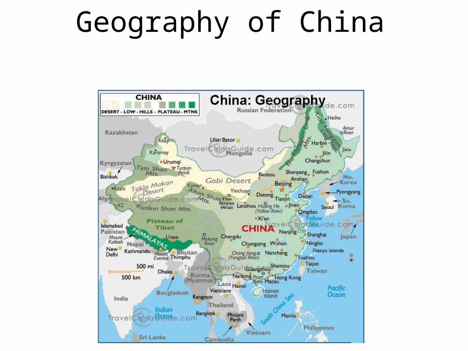
Geography of China

Yellow River• Also known as the Huang He • The 6th longest river in the world– 3,400 miles long
• Yellow because of a material called Loess found in the water
• Sediment builds up in the river, forming natural dams. These natural dams cause major floods– The river has shifted course over 20
times!– Yellow River

Yellow River• Known as “China’s Sorrow” because floods
have devastated the area
How does it help?

Yangtze (Chang Jiang) River• The longest river in Asia. The 3rd longest in the world– 3,900 miles
• Major flooding• Home to Three Gorges Dam, the largest dam in the
world
• http://geography.howstuffworks.com/7143-china-three-gorges-dam-video.htm

Top 10 Deadliest FloodsRank Death toll Event Location Year
1. 2,500,000 + 1931 China Floods- Yangtze River and Yellow River China 1931
2. 2,000,000 + 1887 Yellow River Flood China 1887
3. 700,000 + 1938 Yellow River Flood China 1938
4. 230,000Failure of 62 dams, the largest of which was Bangiaou Dam, result of Typhoon Nina
China 1975
5. 145,000 1935 Yangtze River Flood China 1935
6. Over 100,000 St. Felix Flood, storm surge Netherlands 1530
7. 100,000 Hanoi and Red River Delta flood North Vietnam 1971
8. 100,000 1911 Yangtze River flood China 1911
9. 50,000–80,000 St. Lucia flood, storm surge Netherlands 1287
10. 2,400 North Sea flood, storm surgeScotland,
Netherlands, England, Belgium
1953

East China Sea
• Large sea that borders China, the Korean Peninsula, Japan, and Taiwan
• The Yangtze River flows into the East China Sea
• Dense population on coast

Yellow Sea• Located between mainland China and the
Korean Peninsula– The northern part of the East China Sea
• It is yellow due to sand particles from the Gobi Desert and sediment from the Yellow River

South China Sea• Borders China, Taiwan, the
Philippines, Indonesia, Singapore, Malaysia and Vietnam
• 1/3 of all the world’s ships passes through the South China Sea
• Contains over 250 islands- most uninhabited.

Plateau of Tibet
• Called the “Roof of the World”– The world’s highest and largest plateau– About four times larger than France
• Stretches 1,600 miles east to west and 620 miles north to south

Plateau of Tibet
• Average height is 16,000 feet (about 3 miles high)
• Since the Himalayan Mountains block rain clouds, it is usually very dry
• The Dalai Lama is a spiritual leader of Tibetan Buddhism.
• Tibetan Plateau

The Plateau of Tibet from space

Gobi Desert
• Located in present-day Mongolia• The fifth largest desert in the world– The largest in Asia
• 1,000 miles long and 500 miles wide• A rainshadow desert: – The Himalayan Mountains block rain clouds

Gobi Desert
• Cold Desert– Located far north– High elevation (on a plateau)
• Extreme temperatures: Parts of the Gobi Desert can change up to 95 degrees in 24 hours– Record High: 122 F ̊̊��
– Record Low: -43 F ̊̊��
– Gobi Desert

In your notebook…
• What is the most important geographic feature of China and why?


