Geographic Information System (GIS) Study GIS Study Final02012008.pdfA geographic information system...
51
Geographic Information System (GIS) Study As Directed by House Bill 1473 Section 6.13(a), 6.13(b) and 6.13(c) February 2008 Prepared By: Office of State Budget and Management
Transcript of Geographic Information System (GIS) Study GIS Study Final02012008.pdfA geographic information system...
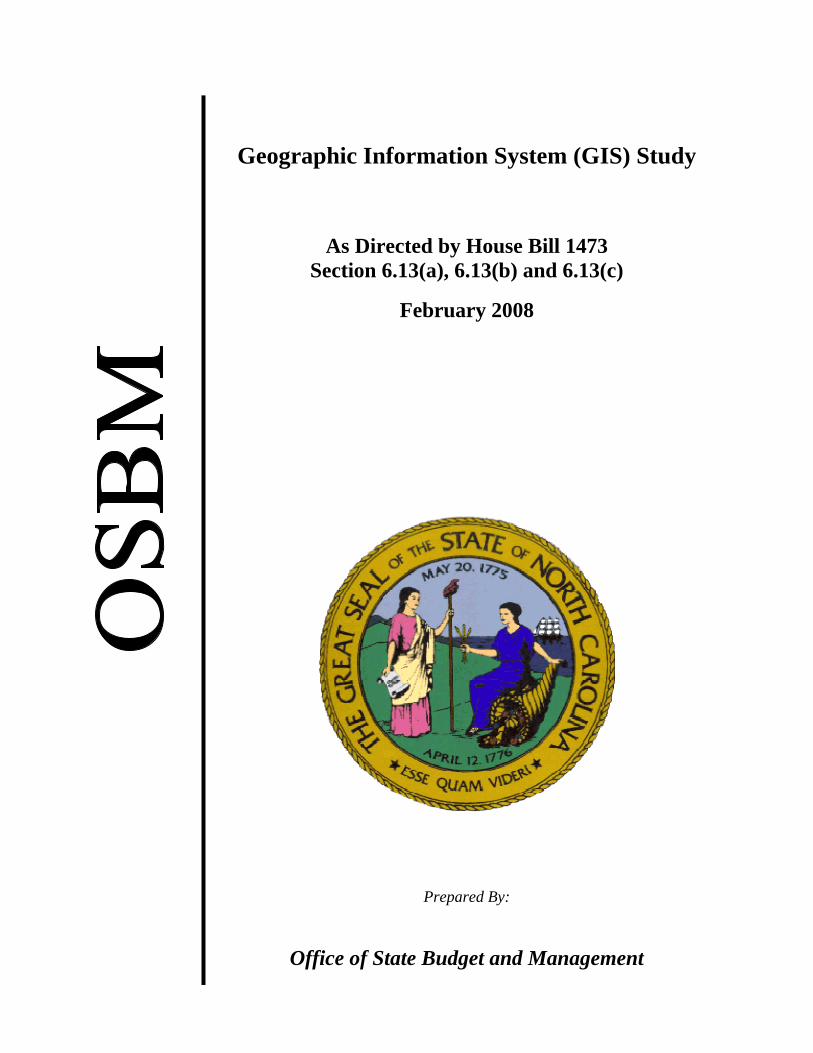
Geographic Information System (GIS) Study
As Directed by House Bill 1473 Section 6.13(a), 6.13(b) and 6.13(c)
February 2008
Prepared By:
Office of State Budget and Management

[THIS PAGE IS INTENTIONALLY LEFT BLANK]
3
TABLE OF CONTENTS Contents Page Executive Summary…………………………………………………………….. 4 Recommendations for improving GIS in North Carolina…………………….…. 5 Introduction……………………………………………………………………….8 Scope of GIS Study……………………………………………………..…….… 8 Methodology……………………………………………………………………. 8 Background……………………………………………………………………… 8 Business Case for GIS in North Carolina ………………………………………. 9 GIS Coordination Criteria……………………………………………………… 11 GIS Survey Findings – Stakeholder Input……………………………………….12 GIS Survey Findings – Data Input……………………………………………… 12 GIS Uses, Users and Resources………………………………………………. .13 GIS Data Update Frequency, Timeliness and Completeness……………….… 15 GIS Data Accessibility…………………………………………………………19 GIS Duplicity………………………………………………………………….…20 Major Areas of Focus and Recommendations…………………………………...23 Governance………………………………………………………………………23 Organization……………………………………………………………………. 25 Staffing / Funding Model………………………………………………………..26 Infrastructure…………………………………………………………………….27 Leveraging Local and Federal Support………………………………………….28 Consolidation of State GIS Initiatives…………………………………………..29 Appendix A: North Carolina GICC Statue 143-725 thru 143-…………………..31 Appendix B: North Carolina OneMap Initial Data Layers to Serve Listing…….35 Appendix C: House Bill 1473 Geographic Information Systems (GIS) Study.....37 Appendix D: Geographic Information Systems Glossary…………………….....38 Appendix E: Spatial View / Table View of GIS Study Survey Participants……46 Appendix F – NSGIC Coordination Criteria – How North Carolina Fares……..48 Appendix G – ILT Business Case by Data Layer……………………………….51

4
EXECUTIVE SUMMARY “As the workforce becomes digitally empowered, geospatial data organized in GIS databases will be critical in the operational functions of most enterprises, private and public, for profit and not for profit, manufacturing, retail, and service. A comprehensive, accurate, and current statewide GIS database would enhance the operational efficiency of North Carolina enterprises and thus boost their productivity and the State's economy”. The above quote from Herb McKim, President of McKim and Creed, a North Carolina based Engineering, Survey and Architectural Firm serving multiple States, addresses a key goal of this study which is to provide recommendations that enable an effective GIS governance and infrastructure to facilitate a statewide GIS database. This goal will only be achieved through a collaborative and cooperative effort throughout the various levels of government, universities, public utilities and the private sector. Geographic Information Systems (GIS) combine layers of data to give needed information on specific locations which provide extremely powerful and critical decision making tools for State and local agencies. Examples of decisions that are made using GIS are the Department of Transportation (DOT) planning highways and understanding environmental impacts, biologists plotting spreads of infectious disease throughout the State, Crime Control & Public Safety determining how best to speed emergency personnel to an accident or a crime scene and legislators making important district line decisions. Showing positional data spatially 1and overlaying critical decision data elements2 enables quicker, better and more informed decisions which in turn lead to savings to tax payers by optimizing service delivery and in many cases, savings of life. The power and value of GIS is not simply in ‘map making’; it is through the analysis of the various data layers3 that manifest the interdependencies of the variables. The power also comes from bringing different levels of government together for more effective problem solving. North Carolina’s General Assembly recognized the importance of GIS and provided statutory authority to set up the Geographic Information Coordinating Council (GICC)4. This has allowed North Carolina to have a National presence as a leader in Statewide GIS coordination and governance maturity. The current structures in place with the GICC, the Center for Geographic Information & Analysis (CGIA)5, and the NC OneMap6 GIS data clearinghouse and North Carolina’s active participation in national GIS
1 Data pertaining to the location of geographical entities together with their spatial dimensions. Spatial data are classified as point, line, area, or surface. 2 Specific item of information appearing in a set of data, e.g. well site locations. 3 Refers to the various "overlays" of data each of which normally deals with one thematic topic. These overlays are registered to each other by the common coordinate system of the database. 4 Reference Appendix A GICC Statute 5 CGIA serves as staff to the GICC and its committees. Reference Appendix A Statue 143-725(b) 6 NC OneMap is the official statewide geospatial data clearinghouse. It is a mechanism for providing a platform for data sharing and collaboration.

5
organizations7 manifest the strength of North Carolina’s GIS focus. North Carolina was the first state to host a statewide GIS conference and it was one of the first States to have Enterprise Licensing for the GIS Environmental Systems Research Institute (ESRI) software8
.
While North Carolina has made significant strides in setting up the structure for enabling GIS, there are several areas where improvements can be made to take GIS for North Carolina to the next level and truly affect synergistic relationships among State agencies and with other levels of government as well as universities, public utilities and private sector firms. More effective and efficient GIS in the State of North Carolina will drive more commerce to the State. It will allow North Carolina to manage environmental challenges better which includes water quantity and quality assessments and land use planning. GIS will also help provide the best response with Emergency Services and Public Safety. It is critical for North Carolina to act now and enable GIS to be used to its fullest potential. The growth of the State over the next twenty-five years is going to be significant. The longer the State lags in moving ahead with concentrated GIS initiatives, the further behind North Carolina will become. The backlog of outdated and unusable data layers will grow which could potentially impede North Carolina’s growth and could catch North Carolina off guard as it did with the acknowledgement of out dated flood maps in eastern North Carolina brought to light by Hurricane Floyd. Therefore, more collaboration and cooperation is needed along with greater investment, allocated more efficiently than at the present time. Investment in GIS today will help ensure North Carolina’s prosperity and high quality of life. RECOMMENDATIONS FOR IMPROVING GIS IN NORTH CAROLINA Governance: ♦ Task the existing Management & Operations (M&O) Committee of the GICC with
the responsibility of setting and managing the Statewide GIS Strategy.
♦ Task the CGIA with the responsibility of coordinating the execution of the Statewide GIS strategy and GICC policies and standards.
♦ Provide the GICC, M&O and the CGIA with the authority to: • Create, update and enforce GIS related standards for State agencies and
collaborate with counties and local municipalities. • Establish Statewide GIS roles and responsibilities for all agencies that develop
and maintain GIS data and give GICC the authority to hold agencies accountable
7 Some of the national GIS organizations include the National States Geographic Information Council (NSGIC), Urban and Regional Information Systems Association (URISA) and GIS Certification Institute (GISCI) 8 ESRI is the world leader in GIS (geographic information system) modeling and mapping software and technology.

6
for updating framework plus other key data layers9 relating to GIS in State agencies.
• Establish data stewards of framework and other key data layers within agencies. ♦ Establish a GIS Reserve account, by which OSBM will have oversight to manage
annual General Assembly appropriated funding for framework data plus other key data layers; funding would be allocated by the M&O Committee to agencies’ data stewards.
• The GICC / CGIA, OSBM and the Agencies will identify both the existing and
required recurring funds for framework data layer maintenance to establish the GIS Reserve account. The amounts must be netted out for any anticipated cost share from federal or local governments.
Organization: ♦ Move the CGIA and all of its responsibilities (currently under DENR) to the State
Chief Information Officer (CIO).
♦ Align the current CGIA Director to report directly to the State CIO.
♦ Leave agency GIS personnel in agencies. Staffing / Funding Model: ♦ Subject to inclusion in the Governor’s Recommended Budget for 2008-09,
appropriate funding for additional CGIA positions.
♦ Leave 15 positions as ‘fee based’ to support the development of multi state agency enterprise GIS product offerings.
♦ Subject to inclusion in the Governor’s Recommended Budget for 2008-09, appropriate funding for an additional OSBM position for GIS Reserve oversight.
Infrastructure: ♦ Subject to inclusion in the Governor’s Recommended Budget for 2008-09,
appropriate funding for system architecture plan and follow up with funding for implementation of that plan to complete the NC OneMap vision.
Leveraging Local and Federal Support: ♦ GICC/CGIA should coordinate a statewide flyover for orthophotography both
logistically and via funding across the different levels of government.
9 Reference Appendix B for a list of framework plus other key data layers served by NC OneMap
7
♦ GICC/CGIA should implement an aggregate cost share model that has Counties contributing 50%, State to contribute 25% and the Federal Government to contribute 25% for a leaf off product based on the GICC adopted orthophotography standard.
♦ Consideration should be given regarding the 50% County participation to ensure counties with very high growth which require more frequent orthophotography pay more of a share versus counties with little to no growth who should pay a much smaller to no share of the cost.
♦ Subject to inclusion in the Governor’s Recommended Budget for 2008-09, appropriate 25% or ($635,625) to the GICC for the State’s participation and / or
♦ Request 911 Board to review the language pertaining to the 911 Fund to consider specifically allocating monies for the State flyover.
♦ GICC via the Department of Crime Control and Public Safety (CCPS) should seek Homeland Security Grants to augment flyover dollars.
♦ Agencies / GICC / CGIA should continue to aggressively seek federal funding grants to fund GIS projects in addition to orthophotography flyovers.
Consolidation of State GIS Initiatives: ♦ Information Technology Projects using GIS should be reviewed by CGIA to ensure
no cross state government agency duplication and to ensure that the business case has been made for the requested investment. If multiple projects are solving the same problem, then an enterprise offering should be considered and built by the CGIA.
♦ State Agencies should evaluate consolidation opportunities to reduce the number of servers if and where appropriate.

8
INTRODUCTION Scope of Study A study provision was passed in House Bill 1473, Section 6.13(a, b & c) that requested the Office of State Budget and Management (OSBM) in consultation with the Center for Geographic Information & Analysis (CGIA), the State Chief Information Officer (SCIO) and the Chairman of the Geographic Information Coordinating Council (GICC) to review Geographic Information Systems (GIS) in North Carolina. The provision called for identifying the development and uses of GIS as well as an assessment of the completeness, timeliness and accessibility of the GIS data. The study provision requested recommendations on governance, organization and staffing and a cost effective State investment strategy for GIS that would leverage local and federal support and eliminate any duplication of capabilities. The full text of the provision can be found in Appendix C. Methodology The following tasks were performed for this study:
• Identified the GIS user contacts in the State agencies, Counties, Municipalities, and Universities10.
• Developed a survey to address ‘uses’ of GIS data in the State of North Carolina. • Requested GIS users to update and /or register their data layer inventories in
North Carolina OneMap to address GIS data development. • Held one on one discussions and round table meetings with over seventy GIS
stakeholders which included State, Federal, Local, County, Public Utilities and Private Sector GIS users to obtain input and views on improving GIS in the State of North Carolina.
• Researched other states’ GIS initiatives. • Met with consulting firm to obtain input on governance and organization best
practices. • Developed self assessment of GIS Coordination Criteria for North Carolina.
BACKGROUND A geographic information system (GIS) is a computer-based data collection, storage and analysis tool that combines previously unrelated information into easily understood maps. GIS gives the public sector manager and the business leader the power to understand complex relationships, the power to plan for tomorrow, the power to present data in a clear and compelling way, the power to make informed decisions, and the power to save time, money and lives. Local governments use GIS technology to manage land records, manage their infrastructure, perform addressing and routing as part of E-911 operations, and for many other purposes. State government agencies use it for school bus routing,
10 Though Universities were exempted (section 6.13c), many filled out the survey since this group is a very important part of the GIS community.
9
management and monitoring of natural resources, emergency response, and tracking of sex offenders, among many other daily uses. BUSINESS CASE FOR GIS IN NORTH CAROLINA The development of a business case is commonplace and fundamental to any corporate entity or government organization seeking success. The creation of a business case involves a structured process upon which organizations address business goals, identify key objectives and identify methods to measure performance. The process is intended to help an organization (or a group of stakeholders such as with NC OneMap) save money and time, increase efficiencies, improve productivity, collaborate, improve revenue streams, and support decision-making. Organizations that implement GIS solutions to address business processes are increasingly aware of the need and value of a solid business case. Because solutions for statewide GIS involve numerous stakeholders who leverage and depend on shared resources across many sectors in the enterprise, it is paramount that a business case model be used to justify individual and comprehensive investment strategies. Investments in GIS should be based on business case fundamentals guided by principles. A recommendation for future business case development is that stakeholders acknowledge the increased inter-reliance and value of their geospatial technology projects in support of business processes across documented priorities. In order to realize the expected benefits and expected return on investments, more formal and tightly integrated partnerships must be in place among key stakeholders during the ‘business case-making’ process and upon implementation. As a result, the statewide community will realize increased opportunities to maximize benefits from shared investments, realize economies of scale benefits, support business lines in focusing on core competencies, and identify opportunities to streamline duplicate investments in infrastructure and data maintenance. The business case for GIS in North Carolina was first established in the 1970s and 1980s as state and local government agencies began to use geospatial data for modernization of land records, for planning of roads and other infrastructure, and for evaluating the state of our natural resources, among other important purposes. Since then, GIS has become a widespread, effective tool in improving service delivery to citizens and as a key element of emergency response, planning and management. The Interagency Leadership Team (ILT) is one important example of the value of geospatial data in support of decision making in North Carolina. A report11 was developed by the ILT12 in March, 2006 and endorsed by the Secretaries of DOT, DENR, Commerce, Cultural Resources and the Wildlife Resources Commission. The intent of the report was to bring attention to the critical need to better coordinate North Carolina’s
11 Reference the following url: http://www.ncdot.org/programs/environment/development/interagency/NCILT/download/Goal1/GISBusiness_CaseReport.pdf 12 Interagency Leadership Team is comprised of cross agency members with the mission to develop and interagency leadership plan for NC to balance successfully mobility, natural and cultural resource protection, community values, and economic vitality.

10
data layer development and maintenance. The report contained a business case13 that addressed the cost of developing and maintaining the key data layers for North Carolina. These investments not only benefit the ILT agencies but all others who rely on current GIS data such as orthophotography, parcel boundaries, roads, and rivers and streams. The total cost, summarized below was $39.2M non recurring and $33.2M recurring over a 10-year period. The investment requirements and corresponding benefits are spread as follows over multiple years:
Year 1 Year 2 Year 3 Year 4 Year 5 Year 6 Year 7 Year 8 Year 9 Year 10Investment Non Recurring $8,971,673 $9,761,600 $9,855,800 $7,373,800 $2,841,000 $216,300 $216,300 Recurring (Maint) $55,430 $976,882 $1,605,382 $2,397,382 $4,128,182 $4,795,971 $4,805,971 $4,795,971 $4,795,971 $4,805,971 Total Cost $9,027,103 $10,738,482 $11,461,182 $9,771,182 $6,969,182 $5,012,271 $5,022,271 $4,795,971 $4,795,971 $4,805,971
Benefits $0 $50,375,722 $50,375,722 $50,375,722 $50,375,722 $50,375,722 $50,375,722 $50,375,722 $50,375,722 $50,375,722
Net (cost) / benefit -$9,027,103 $39,637,240 $38,914,540 $40,604,540 $43,406,540 $45,363,451 $45,353,451 $45,579,751 $45,579,751 $45,569,751 The benefits associated with this investment total $50.4M annually starting in year 2. Though the benefits above are only related to the ILT agencies14, there are considerable upside benefits when non-ILT agencies, private sector and public at large are factored in. The major drivers for the benefits are listed below: • Cost savings can be realized through decreasing the amount of overall time for project delivery through better screening of projects for the Merger process15 and use of GIS to reduce the number of alternatives that need to be carried forward for detailed studies. The largest cost savings are derived from the increased construction costs due to inflation and direct labor savings. • Current and reliable data for decision-making: Each agency that is a stakeholder in the transportation planning and environmental/cultural resource review process can be assured that it is accessing the most current data supplied by the source agency. The stakeholders will be able to be confident of the accuracy, currency, and completeness of the GIS data since it has been updated and maintained specifically to improve those key aspects of the data. • Improved decision making will occur with current, reliable information. The early identification and avoidance of key environmental resources will result in greater efficiencies in the delivery of transportation projects and better predictability of project costs and schedules. These reductions of impacts to these resources will also improve the overall quality of life for North Carolina’s residents. Secondary benefits will come from non-transportation related programs and activities at the local, state and federal levels. One example is the use of GIS in local planning and development efforts. 13 Reference Appendix G for ITL business case by data layer. 14 ILT agencies include DOT, DENR, Commerce, Cultural Resources, Wildlife Resource Commission, and Agriculture, US Army Corps of Engineers, Federal Highway Administration, US Fish & Wildlife Service, US Environmental Protection Agency and National Marine Fisheries Service. 15 Merger 01 is a process to streamline the project development and permitting processes, agreed to by the USACE, NCDENR (DWQ, DCM), FHWA and NCDOT and supported by other stakeholder agencies and local units of government.

11
• Productivity gains: A savings in staff resources will be realized in the review agencies in the long term once the GIS database is up to date, available, and routinely used by the stakeholders in the transportation planning process. The time and resources spent researching and studying transportation alternatives, many of which are eventually deemed unviable because of the impact to resources, will be greatly reduced. GIS COORDINATION CRITERIA In 2005, the Federal Geographic Data Committee (FGDC) initiated a program entitled the “Fifty States Initiative”, a set of policy guidelines for successful GIS operations for states. The National States Geographic Information Council (NSGIC) subsequently published a set of coordination criteria (listed below) that its members believe are essential for effective coordination of GIS at the state level. The criteria are as follows:
1. A full-time paid coordinator position is designated and has the authority to implement the state’s business and strategic plans.
2. A clearly defined authority exists for statewide coordination of geospatial information technologies and data production.
3. The statewide coordination office has a formal relationship with the state’s Chief Information Officer (or similar office).
4. A champion (political or executive decision-maker) is aware and involved in the process of coordination.
5. Responsibilities for developing the National Spatial Data Infrastructure (NSDI) and a State Clearinghouse are assigned.
6. The ability exists to work and coordinate with local governments, academia, and the private sector.
7. Sustainable funding sources exist to meet projected needs. 8. Coordinators have the authority to enter into contracts and become capable of
receiving and expending funds. 9. The Federal government works through the statewide coordinating authority.
Of the nine criteria, North Carolina easily meets eight of them with a conservative self graded ‘C’ or better. Reference Appendix F for a full view of self grading. However, the unmet criterion and very essential element for sustained GIS success is criterion #7 – “Sustainable funding sources to meet projected needs”. The idea of GIS data layer coordination and sustainable funding to ensure consistent, complete and frequently updated data will be a consistent theme throughout the study findings and recommendations. GIS SURVEY FINDINGS GIS survey findings presented below were based on a combination of input from one on one discussions, round table meetings, NC OneMap input/updates and a GIS Study Survey. 16 16 Reference Appendix E for a listing of survey participants
12
GIS Stakeholder Input The overall recurring themes related to improving GIS in North Carolina gathered from the one on one discussions and round table meetings with over seventy GIS stakeholders including Federal, State, County, and City Government, Universities, Public Utilities and Private Sector were as follows:
• Critical need for GIS data layer coordination and sustainable funding to ensure consistent, complete and frequently updated data.
• Appropriated funding is required for the CGIA staff to GICC to allow them to
focus more on coordination, training, consultation and technical out reach of GIS across the State. This would be in lieu of having the CGIA ‘tin cup’ for funding to support ad hoc agency projects and have to add the overhead cost of supporting the GICC to their GIS products provided to the agencies.
• Further develop the cost share model for updating the orthophotography data layer with goal to cover all 100 counties on a regular, timely schedule into the future.
• Better data sharing is needed to solve the problem of repetitive and redundant data
requests by state agencies and local governments.
GIS Data Input GIS Uses, Users and Resources The study revealed that the types of GIS data used by agencies are very diverse. The chart below provides a view of the numerous GIS data types.

13
The next graphic shows the diverse spread of applications that the respondents develop using the GIS data identified in the prior chart. These applications enable critical decision making and optimization of service delivery across a wide range of areas.

14
When building applications from GIS data, the first challenge brought up by most GIS users is locating the data and then ensuring that the data is current and reliable. Often, much time is wasted at this stage. Multiplied across many agencies and users in state government, this is a very inefficient use of finite resources. However, if data layers are consistently updated on a frequent basis and shared centrally (e.g. NC OneMap), the time savings for all stakeholders will be significant. Survey data collected from state agencies conveyed that at least 1,200 employees use GIS data daily for decision making to support their operations. The daily user community is much larger when you add in County and City GIS users. The number of users multiplies even more when the private sector and the public are factored in. Across the state agencies, there are just under 175 dedicated full time equivalents (FTEs) supporting GIS operations, at a cost of approximately $12 million.

15
Annual hardware cost reported by agencies totaled approximately $355,000 per year. Annual software (ESRI)17 costs run approximately $600,000 and that amount is currently paid out of a Statewide Information Technology (IT) Fund. An Enterprise Licensing Agreement (ELA) was procured in 2005 and has proved to be very beneficial by saving the State money. The ELA has also proved to be a key factor, especially for agencies that may not have been able to afford the software licenses, in accelerating the adoption rate of those agencies deploying GIS initiatives. The following chart summarizes, by government entity, the costs for both internal and external GIS data development. Note that this is only a representation of the number of respondents identified in the table below.
Annual Cost of GIS Data Production (includes all FTE costs)
# of In House External / Acquired Total Data Government Entity Respondents Data Production Data Production Production Costs
State Agencies 12 $7,462,668 $7,241,242 $14,703,910Counties 34 $6,841,355 $1,082,200 $7,923,555Cities 16 $3,365,000 $600,000 $3,965,000Council of Government 1 $30,000 $2,500 $32,500 Total $17,699,023 $8,925,942 $26,624,965 External or acquired data production makes up 49% of the respondents’ data production cost for state agencies and at least one-third of the total cost for all government entities. The private sector in North Carolina is very active and productive in delivering data such as orthophotography, elevation, and rivers and streams to government agencies at all levels. GIS Data Update Frequency, Timeliness and Completeness The data layers shown below represent a subset of the 37 key data layers identified by the GICC. The percentages are based on data loaded into the NC OneMap inventory. Directly in sync with the stakeholder input regarding the critical need for coordination and funding to ensure consistent, complete and frequently updated data, the survey findings below show that while a reasonably high number (79% to 88%) of data layers have been completed at some point in time, the maintenance of those data layers from an update frequency and age of data perspective varies widely. Orthophotography, for example, shows that 85% of the data layer is complete, however only 12% of the respondents stated that they update within a four year period and 35% of the respondents stated that their data is greater than 4 years old.
17 ESRI is the world leader in GIS (geographic information system) modeling and mapping software and technology.

16
Geographic Information Systems Study - Data Survey Summary
Completeness of Data Age / Timeliness of DataData Layer Percentage Data Complete (1) Data Update Frequency (2) Percentage data > 4yrs old
Orthophotography 85% 12% 35%
Cadastral 79% 88% n/a
Road Centerlines 88% 76% 48%
Elevation 81% 15% 60%
Hydrography 89% 15% 78%
Land Cover 80% 15% 73%
(1) Completeness reflects the amount of the data layer that was completed at some point in time. (2) Percentage of data updated within a 4 year period. It is encouraging to note that there is tremendous interest across Federal, State, County and City government, Universities, Public Utilities and the Private Sector to use data layers for decision making and optimization of citizen services. However, if the data is not continually updated, the initial investment is wasted. Any data layer with less than 100% completeness and an update frequency with greater than four years impacts the use of the GIS data for effective decision support. Data, displayed spatially below, shows the update frequency and the dates (age) of the orthophotography data layer by County.

17
The data shows that only 12 Counties or 12% of the total counties update their orthophotography every four years or less.

18
The data above shows the 35 Counties reflecting 35% of the total number of counties that have orthophotography data that is greater than four years old. Not only is it key to keep the data layers complete and current, GIS data layers need to be accessible to all stakeholders to reduce the potential for duplication of effort that exists with stakeholders generating data that may have already been completed. It is also critical to have the data layers accessible to avoid having multiple state agencies asking counties and cities for their data.

19
GIS Data Accessibility The stakeholder’s expectation of accessibility of GIS data is for it to be free and accessible for use by all in downloadable formats. The survey respondent data showed that approximately 16% of the respondents from 34 State Agencies, 41 County, 21 City and Town and 11 University responses do not distribute their GIS data. Of the remaining 84%, 36% distributed their GIS data under limited circumstances. An example of ‘limited circumstances’ that was provided related to confidential data that was intended for a specific recipient and not intended for a broader distribution. Of 145 responses, 8 (or 6%) stated that they charged for their data and 54 (or 37%) charged based on conditional circumstances18. Approximately 65% of the GIS data holdings across the State, County, City governments and Universities are not downloadable. Having GIS data downloadable allows users and decision makers to overlay other data attributes and various data layers that manifest the interdependencies of the variables and bring out the real power of GIS. Data stored by the CGIA on NC OneMap is downloadable, however other information from Counties for example are only ‘viewable’ and cannot be downloaded directly from NC OneMap since no links to the data are provided at the NC OneMap source. The vision of NC OneMap is to be the one stop shopping and central repository for GIS data for North Carolina. In order for this vision to be completed, North Carolina needs to get to a state of both viewable and downloadable formats. This will require technical outreach assistance to the State agencies, Counties and Cities, Universities, Public Utilities and the Private Sector to fully understand their current inhibitors to loading data to NC OneMap. That should be followed by the development and implementation of an architecture plan that successfully completes the NC OneMap vision. State, County and City governments have to make all their data accessible via NC OneMap. General feedback regarding NC OneMap is that it has not reached its full potential due to bandwidth, connectivity and data storage problems, but if the problems are corrected most agree that they will make their information accessible. Other input shows that sharing / loading data on NC OneMap is not a priority. That input points to a stovepipe thinking based on stovepipe budgets which leads to independent, parallel development of applications or pieces of applications that could be more efficiently defined, developed, and funded once rather than many times across the state government enterprise. The stovepipe thinking clearly sub optimizes the full potential of GIS for North Carolina and its citizens. Internet mapping is an important component of GIS implementation. The ability to extend the audience of GIS to a larger circle of users magnifies the benefits accrued to 18 Conditional circumstances can include situations where private sector firm makes a request for GIS data from a County and the local government uses the GIS exception in the General Statutes as justification for charging or if in another situation, the requestor may be asking for the entire GIS database which puts a significant burden on the local entity and is clearly something beyond the ‘average’ request.

20
both internal and external GIS stakeholders. Google Earth and Microsoft Virtual Earth are just a couple of the many recognizable names that provide this viewer based mapping. A total of 92 out of 155 or 59% of our State, County, and City government respondents use internet mapping. The critical ingredient for internet mapping and GIS in general is having complete, consistent and updated data available to enable people to build their applications around the GIS data. Stakeholders are relying on the State to adequately invest in the NC OneMap infrastructure to enable them to create viewers specific to their needs and more effectively use the data to make critical decisions. Finally, on the topic of data accessibility, one cannot ignore the subject of Data Sharing. There was a consistent theme within the input from respondents highlighting data sharing as a significant inhibitor to advancing GIS in North Carolina. In fact, this is not a new problem, but one that the GICC sanctioned a workgroup to figure out what can be done to work with all stakeholders collaboratively to eliminate GIS data sharing inhibitors. The workgroup presented a paper with ten recommendations, which were accepted by the GICC, to address data sharing. The full report can be found at the following url: (http://www.ncgicc.org/Portals/3/documents/GICC_DataSharing_Final_11_07.pdf). The paper also identified core best practices and addressed the value and benefits of data sharing. GIS Duplicity The diagram below represents a current state view of the data sharing environment that exists throughout North Carolina. It shows multiple examples of duplication of effort and independent data maintenance processes. This system can generally apply to most data themes such as parcel data or street centerline data. The ovals represent the collection of state agencies, federal agencies, regional governments, or private entities having a business process based on acquiring and aggregating spatial data maintained by local governments, represented by blue geometric shapes. The different blue geometric shapes represent divergent data standards from source to source. The solid blue geometric shapes provide data access to all stakeholders without restrictions, while the light blue shapes denote localities with policies that restrict data distribution to all parties. White filled shapes represent local governments where data is not shared, or data does not exist in a particular jurisdiction. Each arrow represents an independent process to acquire a dataset from a particular local entity, while each of the colored ovals represents an independent process to aggregate and maintain an aggregated dataset. The arrows move data only in one direction, providing negligible returns to local governments. Note that each oval contains a different combination of datasets, and no single oval contains a complete representation of all source datasets.

21
The next diagram shows the full implementation of NC OneMap which provides a more efficient model for data sharing based on streamlining business processes and eliminating duplicative efforts. In this model, local government stakeholders adopt minimum standards for content and presentation (pictured as green outlines to the blue geometric objects), minimally impacting existing standards and business processes at the local government level. These local datasets are shared through a consistent process with the NC OneMap portal (green oval). The NC OneMap services infrastructure (green rectangle) can present a complete and consistent statewide spatial data service, displayed as seven green blocks grouped together. This service will meet the documented business and technical requirements of the stakeholder community. The plum and orange ovals, representing state agencies, regional councils, federal agencies and other stakeholders, can acquire a replicated update of the consolidated dataset (plum) as a service, or access the data resource directly from the NC OneMap infrastructure (orange). Stakeholders at all levels will commit to using NC OneMap services and focus on managing core business data depicted as colored rectangles. The NC OneMap portal will support efficient data sharing across the stakeholder community, shown by the green bi-directional arrows.
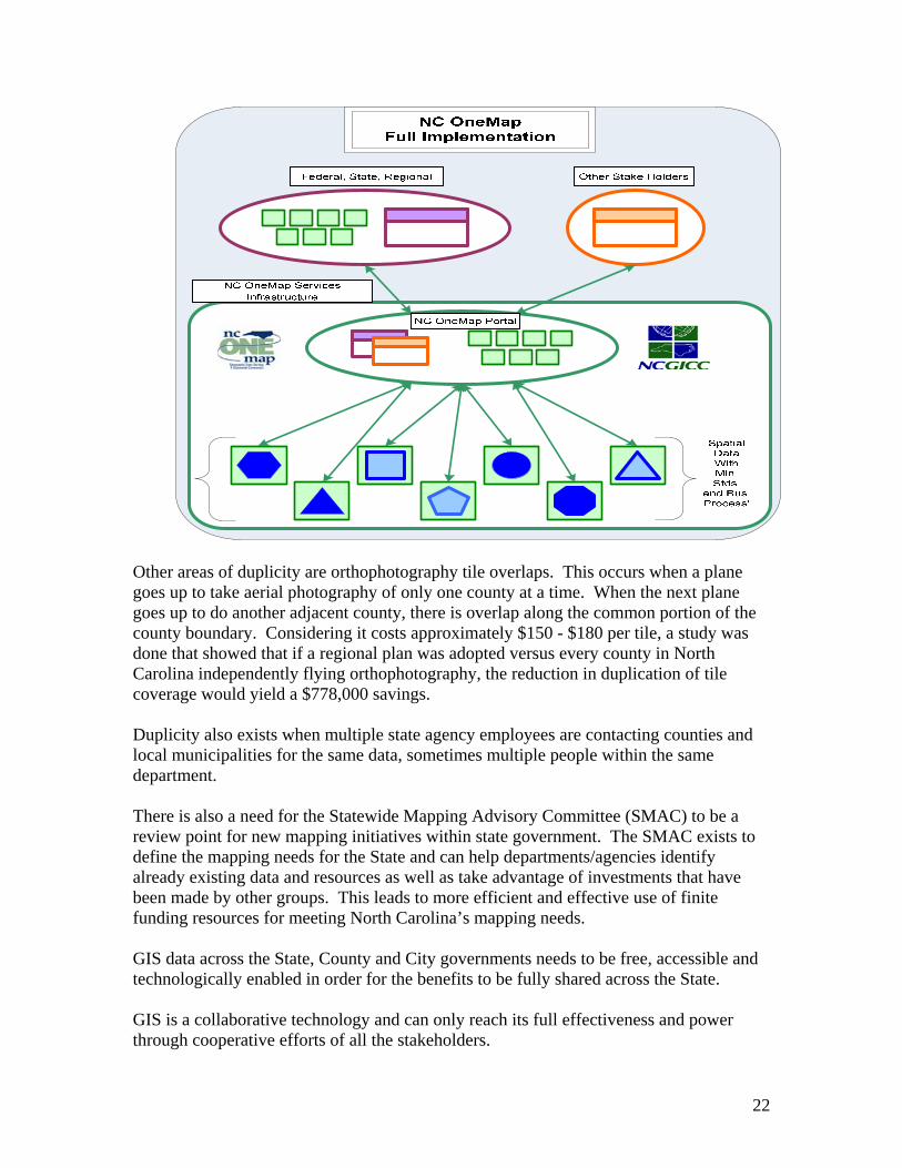
22
Other areas of duplicity are orthophotography tile overlaps. This occurs when a plane goes up to take aerial photography of only one county at a time. When the next plane goes up to do another adjacent county, there is overlap along the common portion of the county boundary. Considering it costs approximately $150 - $180 per tile, a study was done that showed that if a regional plan was adopted versus every county in North Carolina independently flying orthophotography, the reduction in duplication of tile coverage would yield a $778,000 savings. Duplicity also exists when multiple state agency employees are contacting counties and local municipalities for the same data, sometimes multiple people within the same department. There is also a need for the Statewide Mapping Advisory Committee (SMAC) to be a review point for new mapping initiatives within state government. The SMAC exists to define the mapping needs for the State and can help departments/agencies identify already existing data and resources as well as take advantage of investments that have been made by other groups. This leads to more efficient and effective use of finite funding resources for meeting North Carolina’s mapping needs. GIS data across the State, County and City governments needs to be free, accessible and technologically enabled in order for the benefits to be fully shared across the State. GIS is a collaborative technology and can only reach its full effectiveness and power through cooperative efforts of all the stakeholders.

23
Major Areas of Focus and Recommendations The overall survey findings point out specific weaknesses in the “state of GIS” in North Carolina today. It is believed that by adopting the recommendations presented in the sections that follow addressing governance, organization, staffing/funding, infrastructure, leveraging local and federal support and consolidation of state GIS initiatives, North Carolina will be able to fully leverage the power of GIS. Governance: The CGIA currently reports to the Department of Environment and Natural Resources (DENR). Its purpose is statewide geographic information coordination and improving the quality, access, cost-effectiveness, and utility of North Carolina’s geographic information. CGIA’s role is to manage and distribute digital geographic information about North Carolina which is maintained by numerous State and local government departments/agencies and to operate a statewide data clearinghouse. The CGIA staffs the Geographic Information Coordinating Council (GICC) to gain consensus on its coordination mission. The GICC does not have the authority to set standards and hold state agencies accountable for meeting those standards and for GIS data layer maintenance.19 The NC OneMap20 initiative is one example. The GICC membership agreed unanimously on the initiative several years ago as a mechanism for bringing GIS data resources together, making the data more accessible and free of charge. However, some major state government departments are still pursuing their own agendas and seeking funds to do so rather than contributing to the NC OneMap effort. While the GICC has been a good base for developing policy and has done well with advancing this effort by bringing Federal, State and Local government, Universities, Public Utilities and the private sector together, it currently lacks the ‘management’ role that could be accomplished by an executive ‘body’ that would set priorities and translate the GICC visions to execution. From a GICC perspective, there is no consistent Federal liaison so multiple State agencies request federal funding for various GIS projects. The recommended executive ‘body’ would facilitate a coordinated effort under the authority of the SCIO for GIS project funding to avoid fragmentation and to ensure that North Carolina is optimizing GIS investment dollars. The State’s objective is to have the most current GIS data available for both internal and external stakeholders. The executive ‘body’ would ensure consistent GIS execution throughout the State and provide for a single point of contact by which third party providers can interface with and potentially partner with on data production endeavors, aimed again at optimizing GIS investments for North Carolina.
19 Examples of data layers that require maintenance are orthophotography (Aerial Photography), hydrography (Topography pertaining to water and drainage feature), jurisdictional boundaries, elevation, transportation, and geodetic (measurement and representation of the Earth). See Appendix B for extended list of data layers. 20 NC OneMap is the primary discovery and access mechanism for GIS data for the State of NC
24
The GIS community, through the GICC, needs to establish clear stewardship agreements with agencies for specific data layers that the community cares the most about. Each steward would agree to deliver a “data product” as part of NC OneMap and would be responsible for keeping it updated on a regular, ongoing basis. The agreements would specify data content, accuracy, completeness, and timeliness for each product. If clear roles and responsibilities are in place and working, the CGIA can build shared services that the user community can count on. The State CIO, in cooperation with a GICC with some additional authority, should provide greater oversight for GIS in state government agencies. The CGIA should have a tighter alliance with the State CIO. Agencies are very independent in their thinking about GIS. Frequently, if an agency has funding, it pursues a set of tasks that may duplicate an effort in another agency. The much needed authority and coordination can be driven by budgetary alignment of GIS data layer maintenance funds centralized into a GIS Reserve account. The GICC / CGIA, OSBM and the Agencies would identify both the existing and required recurring funds for framework data layer maintenance to establish the GIS Reserve account. The amounts must be netted out for any anticipated cost share from federal or local governments. The funds would be appropriated to the GIS Reserve account on a recurring basis and would be allocated by OSBM to the data stewards for data layer development and maintenance. This will ensure a consistent, complete and updated data layer inventory that will benefit all levels of government and the private sector. Recommendations ♦ Task the existing Management & Operations (M&O) Committee of the GICC with
the responsibility of setting and managing the Statewide GIS Strategy.
♦ Task the CGIA with the responsibility of coordinating the execution of the Statewide GIS Strategy and GICC policies and standards.
♦ Provide the GICC, M&O and the CGIA with the authority to: • Create, update and enforce GIS related standards for State agencies and
collaborate with counties and local municipalities. • Establish Statewide GIS roles and responsibilities for all agencies that develop
and maintain GIS data and give GICC the authority to hold agencies accountable for updating framework plus other key data layers21 relating to GIS in State agencies.
• Establish data stewards of framework and other key data layers within agencies. ♦ Establish a GIS Reserve account, by which OSBM will have oversight to manage
annual General Assembly appropriated funding for framework data plus other key
21 Reference Appendix B for a list of framework plus other key data layers served by NC OneMap
25
data layers allocated according to the priorities set by the M&O Committee to agencies’ data stewards.
• The GICC / CGIA, OSBM and the Agencies to identify both the existing and
required recurring funds for framework data layer maintenance to establish the GIS Reserve account. The amounts must be netted out for any anticipated cost share from federal or local governments.
Organization: GIS expansion budget requests to cover GICC initiatives are currently combined with the many Department of Environment and Natural Resources (DENR) budget requests and many times do not make DENR’s priority list. The CGIA should be aligned with a statewide agency that has experience in providing statewide enterprise services as well as developing and deploying statewide architectural standards. The Office of the State Chief Information Officer (SCIO) is more closely aligned with the mission of CGIA and has a greater ability to help fulfill it. Both CGIA and the Office of the State CIO require funding for statewide initiatives and stringent architecture coordination. It is inefficient to have multiple statewide data architectures especially as more and more data includes geo-coding. The recommendation to move the CGIA under the SCIO is consistent with Gartner Group’s input suggesting that the CGIA move under an already established enterprise (statewide) structure. The move is also consistent with the findings from 11 of 16 (or 69%) of other States that have their GIS groups reporting to the State CIO. Agency GIS personnel should remain in agencies since their work is directly involved with their agency specific GIS business applications. This is consistent with the way that Statewide IT Consolidation is being implemented, with business application employees remaining in the agencies. Recommendations ♦ Move the CGIA and all of its responsibilities (currently under DENR) to the State
Chief Information Officer (CIO).
♦ Align the current CGIA Director to report directly to the State CIO.
♦ Leave agency GIS personnel in agencies.

26
Staffing / Funding Model: The CGIA staff consists of twenty-five staff positions. Two positions which include a NC OneMap Data Base Administrator and a NC OneMap Programmer are appropriated. The remaining twenty-three CGIA positions are receipt based. The receipts based funding model is not optimal and has not been effective in allowing the CGIA to develop a strategic Statewide GIS plan that prioritizes GIS needs which optimize the return to the State and the citizens. The CGIA staff members that support the Council are part of the CGIA rate structure, essentially overhead charged to client projects. Therefore, GIS service projects that are unrelated to the GICC are being charged at a higher rate than necessary to cover the overhead cost of the GICC support. Since the CGIA can only work on projects for agencies that have money to pay the CGIA for their receipts supported positions, projects tend to be of an ad hoc nature and may or may not fit into the strategic GIS priorities of the State. Other agencies may have critical strategic GIS needs, but lack the funding resources to pay for the CGIA’s services. Round table input from stakeholders clearly manifested that agencies did not like paying the overhead of the GICC staff and some stated that they could go external and get the desired GIS product for less cost. An alternative would be to have state appropriations to fund the GICC staff and support functions, allowing the following:
• The CGIA to price more competitively by substantially lowering its labor rates which will attract more public sector customers.
• The CGIA to do what the GIS community has been requesting which is to coordinate, train, consult and provide technical out reach services with state agencies, counties, and municipalities to further drive GIS throughout the State.
• Provide for a consistent development and application of a Statewide GIS strategy.
This action will leave the remaining 15 positions as ‘fee based’ to support the development of multiple state agency enterprise GIS product offerings. The number of filled positions will be driven by the demand for enterprise services. An example of an enterprise GIS product offering is the ‘address locator tool’ which allows a user to type in an address and retrieves an exact location, based on NC OneMap data, of that address. The Sex Offender Registry uses this technology. DENR, DHHS and DOR are just a few of what could be many agencies interested in implementing this, but they cannot afford the upfront infrastructure cost. This is an area where the CGIA could build the tool and offer it as an enterprise level service. It would save the State money by alleviating three or more agencies from doing it on their own or going out independently to various vendors. The proposed level of state appropriated positions is consistent with many of the States that provided input for this study. Nine of the sixteen states (or 56%) providing input all

27
had an element of state general funding for their GIS positions. They augmented the state general funding with federal grants and fee based services. See chart below for the proposed CGIA organization and funding source.
Recommendations ♦ Subject to inclusion in the Governor’s Recommended Budget for 2008-09,
appropriate funding for additional CGIA positions.
♦ Leave 15 positions as ‘fee based’ to support the development of multi state agency enterprise GIS product offerings.
♦ Subject to inclusion in the Governor’s Recommended Budget for 2008-09, appropriate funding for an additional OSBM position for GIS Reserve oversight.
Infrastructure: NC OneMap is a key initiative of the GICC and is a collection of central and distributed services organized within a network of local, regional, and state, and federal agency stakeholders. NC OneMap needs improvements to facilitate the completion of the

28
vision22 of having a virtual repository. In the current environment, 60 local government connections to NC OneMap translate to 60 potential points of failure in the event of computer system problems, power outages, or other unplanned events that could occur across North Carolina. This is unacceptable to the stakeholder community and limits the reliance that can be placed on the availability of the NC OneMap data resource. Bandwidth, connectivity, storage and a more simplified interface must be addressed to improve the use of this key GIS repository. To achieve these technical objectives, NC OneMap needs to implement a system architecture plan for supporting 24x7 operations that will meet the needs of stakeholders across North Carolina. NC OneMap is one of the pinnacles of moving North Carolina’s GIS to the next level since it is the common ground or sharing point for all the data. If NC OneMap is not fully enabled, the 100 counties and numerous cities will not be able to connect and upload their data for everyone to share and agencies will seek other solutions to meet their business needs for geospatial data. Appropriating funding for a system architecture plan and following up with funding for implementation of that plan to complete the NC OneMap vision will enable more participants to use NC OneMap and to share data which will derive more benefits through the cost avoidance of recreating data files and data layers that already exist. Recommendation ♦ Subject to inclusion in the Governor’s Recommended Budget for 2008-09,
appropriate funding for system architecture plan and follow up with funding for implementation of that plan to complete the NC OneMap vision.
Leveraging Local and Federal Support: Orthophotography (Aerial Photography) is an area where duplicity exists and where there is opportunity for leveraging local and federal funding. Currently Counties, DOT, NAIP23 , USGS and others collect orthophotography via flyovers. Some require 6-inch image granularity and others require less granularity (e.g. 2-meter imagery). USDA requires flyovers when the leaves are on the trees (leaf on) to delineate agriculture fields, but DOT and others require flyovers when the leaves are off (leaf off) so they can see roads, power lines, streams etc. more effectively. Individual counties often fly their county independent of other counties due to differing budget priorities and other business reasons. Some success has been made, to date with multi-county flyovers which save money from having the plane go up numerous times doing one county and then going up again to do adjacent counties’ orthophotography.
22 NC OneMap’s vision is to be the State of NC’s one stop shopping for GIS information. Due to some technical limitations, many state agencies and local governments do not (cannot) use NC OneMap which impedes the vision. 23 National Agricultural Imagery Program (NAIP) run by USDA.
29
If a State coordinated effort could achieve a coordinated flyover that addressed 25% state coverage per year, all parties would benefit from updated aerial imagery every 4 years and monies could be saved by avoiding duplicate flyovers and avoiding overlap areas at county boundaries. Federal and local government’s funds and resources should be leveraged to optimize fund matches and flyovers could be further augmented with specific county and federal funding that require special requests. Aside from federal funding dollars available for orthophotography, many agencies today obtain considerable amounts of federal dollars to execute their specific GIS projects and initiatives within their agencies. Recommendations ♦ GICC/CGIA should coordinate a statewide flyover for orthophotography both
logistically and via funding across the different levels of government.
♦ GICC/CGIA should implement an aggregate cost share model that has Counties contributing 50%, State to contribute 25% and the Federal Government to contribute 25% for a leaf off product based on the GICC-adopted orthophotography standard.
♦ Consideration should be given regarding the 50% County participation to ensure counties with very high growth which require more frequent orthophotography pay more of a share versus counties with little to no growth who should pay a much smaller to no share of the cost.
♦ Subject to inclusion in the Governor’s Recommended Budget for 2008-09, appropriate 25% or ($635,625) to the GICC for the State’s participation and / or
♦ Request 911 Board to review the language pertaining to the 911 Fund to consider specifically allocating monies for the State flyover.
♦ GICC via CCPS should seek Homeland Security Grants to augment flyover dollars.
♦ Agencies / GICC / CGIA should continue to aggressively seek federal funding grants to fund GIS projects in addition to orthophotography flyovers.
Consolidation of State GIS Initiatives: There is a potential for GIS duplication with agencies submitting expansion budget requests for similar type GIS initiatives. To date, this duplication has been somewhat averted by the implementation of the Portfolio Project Management tool and review process. However, expertise of GIS and the interrelationships of the various GIS projects are better suited for review by CGIA as staff to the GICC. GIS hardware (e.g. servers) within state agencies will be consolidated through the IT Consolidation initiative; however that should not preclude State Agencies from

30
capitalizing on opportunities to consolidate servers where appropriate. Survey input indicated that of the 12 agencies responding, there were a total of 87 servers dedicated to GIS. As expected, due to their significant GIS reliance, the Department of Crime Control and Public Safety, Department of Environment and Natural Resources and Department of Transportation had the larger number of servers. Recommendations ♦ Information Technology Projects using GIS should be reviewed by CGIA to ensure
no cross state government agency duplication and ensure that the business case has been made for the requested investment. If multiple projects are solving the same problem, then an enterprise offering should be considered and built by the CGIA.
♦ State Agencies should evaluate consolidation opportunities to reduce the number of servers if and where appropriate.
31
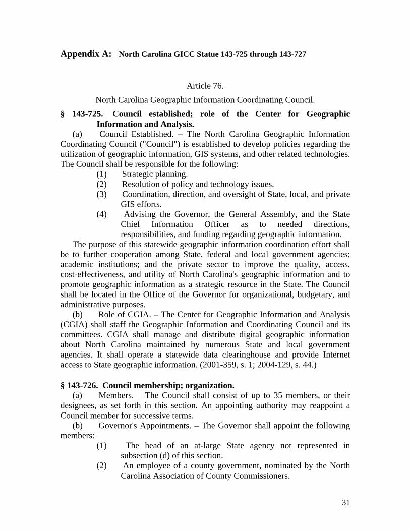
Appendix A: North Carolina GICC Statue 143-725 through 143-727
Article 76. North Carolina Geographic Information Coordinating Council.
§ 143-725. Council established; role of the Center for Geographic Information and Analysis.
(a) Council Established. – The North Carolina Geographic Information Coordinating Council ("Council") is established to develop policies regarding the utilization of geographic information, GIS systems, and other related technologies. The Council shall be responsible for the following:
(1) Strategic planning. (2) Resolution of policy and technology issues. (3) Coordination, direction, and oversight of State, local, and private
GIS efforts. (4) Advising the Governor, the General Assembly, and the State
Chief Information Officer as to needed directions, responsibilities, and funding regarding geographic information.
The purpose of this statewide geographic information coordination effort shall be to further cooperation among State, federal and local government agencies; academic institutions; and the private sector to improve the quality, access, cost-effectiveness, and utility of North Carolina's geographic information and to promote geographic information as a strategic resource in the State. The Council shall be located in the Office of the Governor for organizational, budgetary, and administrative purposes.
(b) Role of CGIA. – The Center for Geographic Information and Analysis (CGIA) shall staff the Geographic Information and Coordinating Council and its committees. CGIA shall manage and distribute digital geographic information about North Carolina maintained by numerous State and local government agencies. It shall operate a statewide data clearinghouse and provide Internet access to State geographic information. (2001-359, s. 1; 2004-129, s. 44.) § 143-726. Council membership; organization.
(a) Members. – The Council shall consist of up to 35 members, or their designees, as set forth in this section. An appointing authority may reappoint a Council member for successive terms.
(b) Governor's Appointments. – The Governor shall appoint the following members:
(1) The head of an at-large State agency not represented in subsection (d) of this section.
(2) An employee of a county government, nominated by the North Carolina Association of County Commissioners.

32
Appendix A: North Carolina GICC Statue 143-725 through 143-727 continued (3) An employee of a municipal government, nominated by the
North Carolina League of Municipalities. (4) An employee of the federal government who is stationed in
North Carolina. (5) A representative from the Lead Regional Organizations. (6) A member of the general public. (7) Other individuals whom the Governor deems appropriate to
enhance the efforts of geographic information coordination. Members appointed by the Governor shall serve three-year terms. The
Governor shall appoint an individual from the membership of the Council to serve as Chair of the Council. The member appointed shall serve as Chair for a term of one year.
(c) General Assembly Appointments. – The President Pro Tempore of the Senate and the Speaker of the House of Representatives shall each appoint three members to the Council. These members shall serve one-year terms.
(d) Other Members. – Other Council members shall include: (1) The Secretary of State. (2) The Commissioner of Agriculture. (3) The Superintendent of Public Instruction. (4) The Secretary of Environment and Natural Resources. (5) The Secretary of the Department of Transportation. (6) The Secretary of the Department of Administration. (7) The Secretary of the Department of Commerce. (8) The Secretary of the Department of Crime Control and Public
Safety. (9) The Secretary of the Department of Health and Human Services. (10) The Secretary of the Department of Revenue. (11) The President of the North Carolina Community Colleges
System. (12) The President of The University of North Carolina System. (13) The Chair of the Public Utilities Commission. (14) The State Budget Officer. (15) The Executive Director of the North Carolina League of
Municipalities. (16) The Executive Director of the North Carolina Association of
County Commissioners. (17) One representative from the State Government GIS User
Committee. (18) One representative elected annually from the Local Government
Committee established pursuant to subdivision (h)(2) of this section.

33
Appendix A: North Carolina GICC Statue 143-725 through 143-727 continued (19) The State Chief Information Officer who shall serve as a
nonvoting member. Council members serving ex officio pursuant to this subsection shall serve
terms coinciding with their respective offices. Members serving by virtue of their appointment by a standing committee of the Council shall serve for the duration of their appointment by the standing committee.
(e) Meetings. – The Council shall meet at least quarterly on the call of the Chair. The Management and Operations Committee shall conduct the Council's business between quarterly meetings.
(f) Administration. – The Director of the CGIA shall be secretary of the Council and provide staff support as it requires.
(g) Reports. – The Council shall report at least annually to the Governor and to the Joint Legislative Commission on Governmental Operations.
(h) Committees. – The Council may establish work groups, as needed, and shall oversee the standing committees created in this subsection. Each standing committee shall adopt bylaws, subject to the Council's approval, to govern its proceedings. Except as otherwise provided, the Chair of the Council shall appoint the standing committee chairs from representatives listed in subsections (b), (c), or (d) of this section. The standing committees are as follows:
(1) State Government GIS User Committee. – Membership shall consist of representatives from all interested State government departments. The Chair of the Council shall appoint the committee chair from one of the State agencies represented in subsection (d) of this section.
(2) Local Government Committee. – Membership shall consist of representatives from organizations and professional associations that currently serve or represent local government GIS users, the North Carolina League of Municipalities, the North Carolina Association of County Commissioners, and Lead Regional Organizations. The committee shall elect one of its members to the Council.
(3) Federal Interagency Committee. – Membership shall consist of representatives from all interested federal agencies and Tribal governments with an office located in North Carolina. The appointed federal representative serving pursuant to subdivision (b)(4) of this section shall serve as the Chair of the Federal Interagency Committee.
(4) Statewide Mapping Advisory Committee. – This committee shall consolidate statewide mapping requirements and attempt to gain statewide support for financing cooperative programs. The committee shall also advise the Council on issues, problems, and

34
Appendix A: North Carolina GICC Statue 143-725 through 143-727 continued opportunities relating to federal, State, and local government geospatial
data programs. (5) GIS Technical Advisory Committee. – This committee shall
develop the statewide technical architecture for GIS and anticipate and respond to GIS technical opportunities and issues affecting State, county, and local governments in North Carolina.
(6) Management and Operations Committee. – This committee shall consider management and operational matters related to GIS and other matters that are formally requested by the Council. The committee membership shall consist of the Chair of the Council, the State Budget Officer, the chair of each of the standing committees of the Council, and other members of the Council appointed by the Chair. (2001-359, s. 1; 2003-340, s. 1.9.)
§ 143-727. Compensation and expenses of Council members; travel
reimbursements. Members of the Council shall serve without compensation but may receive
travel and subsistence as follows: (1) Council members who are officials or employees of a State
agency or unit of local government, in accordance with G.S. 138-6.
(2) All other Council members at the rate established in G.S. 138-5. (2001-359, s. 1.)
35
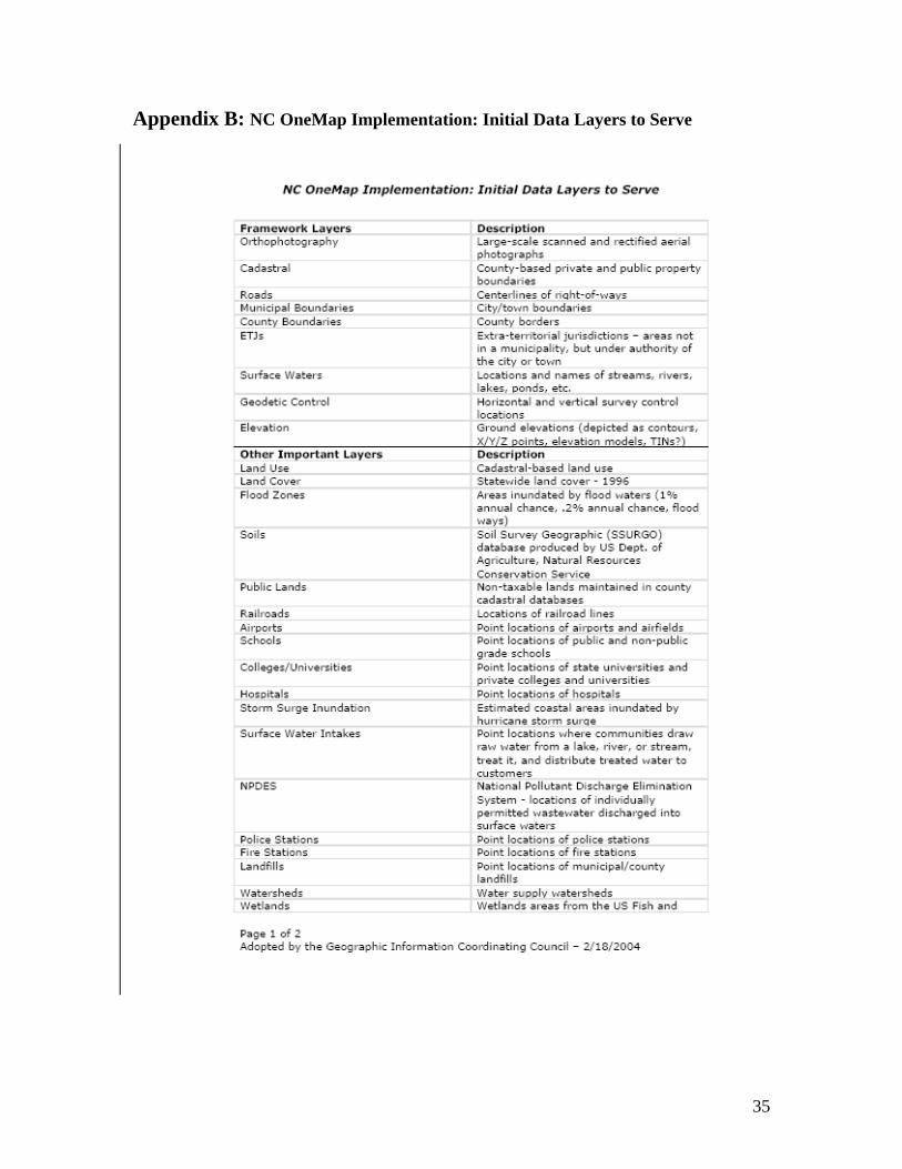
Appendix B: NC OneMap Implementation: Initial Data Layers to Serve

36
Appendix B: NC OneMap Implementation: Initial Data Layers to Serve continued

37
Appendix C – House Bill 1473 Geographic Information Systems (GIS) Study SECTION 6.13.(a) The Office of State Budget and Management (OSBM), in consultation with the Center for Geographic Information and Analysis (CGIA), the State Chief Information Officer, and the chair of the Geographic Information Coordinating Council (GICC), shall conduct a study to identify the development and use of Geographical Information Systems (GIS) in North Carolina by State agencies. The study shall identify the purpose of each system; any duplication of effort across agencies, including local governments and federal agencies; the completeness, timeliness, and accessibility of the data developed and used by the systems; the cost and actual staffing for each system; the organizational location of each system; and the hardware and software inventories associated with each system. The study shall also assess the current and potential benefits that GIS investments provide to the State and identify opportunities for the State to leverage federal and local support for North Carolina GIS systems. SECTION 6.13.(b) OSBM shall make recommendations on the governance, organization, and staffing of GIS in and across State agencies and on a coherent and cost-effective State investment strategy for GIS that appropriately leverages local and federal support and eliminates duplication of capabilities. The report shall include a recommended strategy for consolidating State GIS initiatives. The OSBM shall make a written report of these findings and recommendations to the General Assembly by April 30, 2008. SECTION 6.13.(c) This section does not apply to The University of North Carolina or to the Judicial Branch.

38
Appendix D – Glossary
Aerial - Relating to the air atmosphere, being applicable in a descriptive sense to anything in space above the ground and within the atmosphere.
Aerial Photography - The method of taking photographs from an aerial platform (aircraft). (1.) Vertical photography, some times called orthophotography, is used for photogrammetric mapping and requires a high degree of accuracy. (2.) Oblique photography is used for general information, sometimes to verify certain attributes, but does not provide accurate measurements for photogrammetric mapping.
Aerial Survey - A survey utilizing aerial photography or from remote sensing technology using other bands of the electromagnetic spectrum such as infrared, gamma or ultraviolet.
Algorithm - A set of instructions; ordered mathematical steps for solving a problem like the instructions in a computer program.
Alignment - Relates to survey data transposed to maps. The correct position of a line or feature in relation to other lines or features. Also the correct placement of points along a straight line.
Alphanumeric - A combination of alphabetic letters, numbers and or special characters. A mailing address is an alphanumeric listing.
Analog Data - Data represented in a continuous form, not readable by a computer.
Area - level of spatial measurement referring to a two-dimensional defined space; for example, a polygon on the earth as projected onto a horizontal plane.
Base Data - set of information that provides a baseline orientation for another layer of primary focus, e.g., roads, streams, and other data typically found on USGS topographic and/or planimetric maps.
Base Line - A surveyed line established with more than usual care upon which surveys are based.
Base Map - A map showing planimetric, topographic, geological, political, and/or cadastral information that may appear in many different types of maps. The base map information is drawn with other types of changing thematic information. Base map information may be as simple as major political boundaries, major hydrographic data, or major roads. The changing thematic information may be bus routes, population distribution, or caribou migration routes.

39
Appendix D – Glossary - continued
Boundary Line - A line along which two areas meet. In specific cases, the word "boundary" is sometimes omitted, as in "state line", sometimes the word "line" is omitted, as in "international boundary", "county boundary", etc. The term "boundary line" is usually applied to boundaries between political territories, as "state boundary line", between two states. A boundary line between privately owned parcels of land is termed a property line by preference, or if a line of the United States public land surveys, is given the particular designation of that survey system, as section line, township line, etc.
Cadastral - Relating to the value, extent and ownership of land for tax purposes. Cadastral maps describe and record ownership. Also called property map.
Cadastral Survey - A survey relating to land boundaries and subdivisions, made to create units suitable for transfer or to define the limitations to title. Derived from "cadastre", and meaning register of the real property of a political subdivision with details of area, ownership, and value. The term cadastral survey is now used to designate the surveys for the identification and resurveys for the restoration of property lines; the term can also be applied properly to corresponding surveys outside the public lands, although such surveys are usually termed land surveys through preference. Cartographic (Planimetric) Features - Objects like trees or buildings shown on a map or chart.
Cartography - The technology of mapping or charting features of Earth's topography.
CCPS – Department of Crime Control and Public Safety
CGIA – Center for Geographic Information and Analysis; an agency in the Department of Environment and Natural Resources that serves as the lead GIS agency in North Carolina; serves as staff to the Geographic Information Coordinating Council.
Clearinghouse - a physical repository structure used to accumulate and disseminate digital data and information concerning that data. In the GIS context a clearinghouse can contain all or a portion of spatial, meta data and informational data.
Coordinate - The position of point is space in respect to a Cartesian coordinate system (x, y and/or z values). In GIS, a coordinate often represents locations on the earth's surface relative to other locations.
Coordinate System - The system used to measure horizontal and vertical distances on a planimetric map. In a GIS, it is the system whose units and characteristics are defined by a map projection. A common coordinate system is used to spatially register geographic data for the same area.
40
Appendix D – Glossary - continued
Data Element - specific item of information appearing in a set of data, e.g. well site locations.
Data Model 1. A generalized, user-defined view of the data related to applications. 2. A formal method for arranging data to mimic the behavior of the real world entities they represent. Fully developed data models describe data types, integrity rules for the data types, and operations on the data types. Some data models are triangulated irregular networks, images, and georelational or relational models for tabular data.
DENR – Department of Environmental and Natural Resources
DHHS – Department of Health and Human Services
DOR – Department of Revenue
DOT – Department of Transportation
Data Quality - refers to the degree of excellence exhibited by the data in relation to the portrayal of the actual phenomena.
Data Sets - a collection of values that all pertain to a single subject.
Data Standardization - the process of achieving agreement on data definitions, representation, and structures to which all data layers and elements in an organization must conform.
Data Structure - organization of data, particularly the reference linkages among data elements.
Database -usually a computerized file or series of files of information, maps, diagrams, listings, location records, abstracts, or references on a particular subject or subjects organized by data sets and governed by a scheme of organization. "Hierarchical" and relational" define two popular structural schemes in use in a GIS. For example, a GIS database includes data about the spatial location and shape of geographic entities as well as their attributes.
Digital Accuracy - refers to the accuracy of digital spatial data capture.
Digital Elevation Model (DEM) - a file with terrain elevations recorded at the intersections of a fine grid and organized by quadrangle to be the digital equivalent of the elevation data on a topographic base map.

41
Appendix D – Glossary – continued
Digital Data - a form of representation in which distinct objects, or digits, are used to stand for something in the real world--temperature or time--so that counting and other operations can be performed precisely. Data represented digitally can be manipulated to produce a calculation, a sort, or some other computation. In digital electronic computers, two electrical states correspond to the Is and Os of binary numbers, which are manipulated by computer programs.
Federal Geographic Data Committee (FGDC) - established by the Federal Office of Management and Budget, is responsible for the coordination of development, use, sharing, and dissemination of surveying, mapping, and related spatial data.
File Transfer Protocol (FTP) - a standard protocol that defines how to transfer files from one computer to another.
Geographic - Pertains to the study of the Earth and the locations of living things, humans and their effects.
Geographic Database - Efficiently stored and organized spatial data and possibly related descriptive data.
Geographic Information System (GIS) - An organized collection of computer hardware, software, geographic data, and personnel designed to efficiently capture, store, update, manipulate, analyze, and display all forms of geographically referenced information. Certain complex spatial operations are possible with a GIS that would be very difficult, time-consuming, or impractical otherwise.
Geographic Object - A user-defined geographic phenomenon that can be modeled or represented using geographic data sets. Examples include streets, sewer lines, manhole covers, accidents, lot lines, and parcels.
Georectify - the process of referencing points on an image to the real world coordinates.
Georeference - To establish the relationship between page coordinates on a paper map or manuscript and known real-world coordinates.
Geospatial - a term used to describe a class of data that has a geographic or spatial nature.
GICC – Geographic Information Coordinating Council; a 34-member policymaking body established in the General Statutes in 2001 (§ 143-725 through 143-727) to further cooperation among public sector agencies, the private sector, and academic institutions; reports to the Governor and the General Assembly as to needed directions, responsibilities, and funding.

42
Appendix D – Glossary – continued
GIS - Geographic information system. A computer system of hardware and software that integrates graphics with databases and allows for display, analysis, and modeling.
Global Positioning System (GPS) - a system developed by the U.S. Department of Defense based on 24 satellites orbiting the Earth. Inexpensive GPS receivers can accurately determine ones position on the Earth's surface.
Hierarchical - A way of classifying data, starting with the general and going to specific labels.
Hydrography – Topography pertaining to water and drainage feature.
Image - A graphic representation or description of an object that is typically produced by an optical or electronic device. Common examples include remotely sensed data such as satellite data, scanned data, and photographs. An image is stored as a raster data set of binary or integer values representing the intensity of reflected light, heat, or another range of values on the electromagnetic spectrum. Remotely sensed images are digital representations of the earth.
Imagery - a two dimensional digital representation of the earth's surface. Examples are a digital aerial photograph, a satellite scene, or an airborne radar scan.
Internet - a system of linked computer networks, worldwide in scope, that facilitates data communication services such as remote login, file transfer, electronic mail, and newsgroups. The Internet is a way of connecting existing computer networks that greatly extends the reach of each participating system.
Internet Protocol (IP) - the most important of the protocols on which the Internet is based. It allows a packet to traverse multiple networks on the way to its final destination.
IT - Information Technology
Latitude - The north-south measurement parallel to the equator.
Layer- A logical set of thematic data, usually organized by subject matter; examples include parcel boundaries, roads, rivers and streams, and jurisdictional boundaries.
Layers - refers to the various "overlays" of data each of which normally deals with one thematic topic. These overlays are registered to each other by the common coordinate system of the database.

43
Appendix D – Glossary – continued
Longitude - The angular distance, measured in degrees, cast or west from the Greenwich meridian, or by the difference in time between two reference meridians on a globe or sphere.
Map - A representation of a portion of the earth, usually drawn on a flat surface. (From Latin mappa, a napkin, sheet or cloth upon which maps were drawn.)
Metadata - data describing a GIS database or data set including, but not limited to, a description of a data transfer mediums, format, and contents, source lineage data, and any other applicable data processing algorithms or procedures.
NCGIA - National Center for Geographic Information and Analysis
NSGIC - National States Geographic Information Council
NSDI - National Spatial Data Infrastructure
Orthophoto - A photograph of the earth's surface in which geographic distortion has been removed.
Overlay - A layer of data representing one aspect of related information.
Parcel - Generally refers to a piece of land that can be designated by number.
Photogrammetry - The system of gathering information about physical objects through aerial photography and satellite imagery.
Point Data - level of spatial definition referring to an object that has no dimension, e.g., well or weather station.
Points - Items such as oil wells, utility poles, etc. Specific objects with exact location noted.
Positional Accuracy - term used in evaluating the overall reliability of the positions of cartographic features relative to their true position.
Precision - refers to the quality of the operation by which the result is obtained, as distinguished from accuracy.
44
Appendix D – Glossary - continued
Quality Control - process of taking steps to ensure the quality of data or operations is in keeping with standards set for the system.
Relational Database Management System (RDBMS) - A database management system with the ability to access data organized in tabular files that may be related together by common field (item). An RDBMS has the capability to recombine the data items from different files, thus providing powerful tools for data usage.
Scale - the relationship between a distance on a map and the corresponding distance on the earth. Often used in the form I: 24,000, which means that one unit of measurement on the map equals 24,000 of the same units on the earth's surface.
Server - software that allows a computer to offer a service to another computer. Other computers contact the server program by means of matching client software. Also a computer using server software.
Spatial Data - data pertaining to the location of geographical entities together with their spatial dimensions. Spatial data are classified as point, line, area, or surface.
Spatial Index - A means of accelerating the drawing, spatial selection, and entity identification by generating geographic-based indexes. Usually based on an internal sequential numbering system.
Spatial Model - Analytical procedures applied with a GIS. There are three categories of spatial modeling functions that can be applied to geographic data objects within a GIS: (1) geometric models (such as calculation of Euclidian distance between objects, buffer generation area, and perimeter calculation); (2) coincidence models (such as a polygon overlay); and (3) adjacency models (pathfinding, redistricting, and allocation). All three model categories support operations on geographic data objects such as points, lines, polygons, TlNs, and grids. Functions are organized in a sequence of steps to derive the desired information for analysis.
Stakeholders - Any constituency in the environment that is affected by an organization's decisions and policies.
Standards - In computing, a set of rules or specifications which, taken together, define the architecture of a hardware device, program, or operating system.
System - A group of related or interdependent elements that function as a unit.
Topographic Map - A map of land-source features including drainage lines, roads, landmarks, and usually relief, or elevation.

45
Appendix D – Glossary - continued
Topology - The spatial relationships between connecting or adjacent coverage features (e.g., arcs, nodes, polygons, and points). For example, the topology of an arc includes its from- and to- nodes and its left and right polygons. Topological relationships are built from simple elements into complex elements: points (simplest elements), arcs (sets of connected points), areas (sets of connected arcs), and routes (sets of sections) that are arcs or portions of arcs). Redundant data (coordinates) are eliminated because an arc may represent a linear feature, part of the boundary of an area feature, or both. Topology is useful in GIS because many spatial modeling operations don't require coordinates, only topological information. For example, to find an optimal path between two points requires a list of which arcs connect to each other and the cost of traversing along each arc in each direction. Coordinates are only necessary to draw the path after it is calculated.
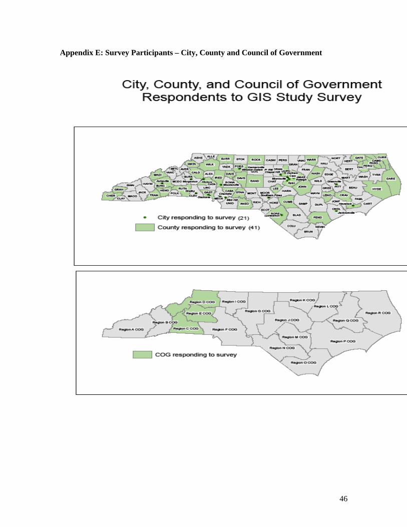
46
Appendix E: Survey Participants – City, County and Council of Government

47
Appendix E: Survey Participants - State Agency and Higher Education - continued Survey Participants State Government NC Clean Water Management Trust Fund NC DCR, Archives and History NC DCR, ITS NC DCR, State Historic Preservation Office NC DENR, Air Quality NC DENR, Center for Geographic Info and Analysis NC DENR, Coastal Management NC DENR, Ecosystem Enhancement Program NC DENR, Environmental Education NC DENR, Environmental Health NC DENR, ITS NC DENR, Marine Fisheries NC DENR, Soil and Water Conservation NC DENR, Water Quality NC DENR, Wildlife Resources Commission NC Department of Administration, Gov't Operations NC Department of Agriculture and Consumer Services NC Department of Commerce NC Department of Commerce, Community Assistance NC Department of Commerce, NC Utilities Commission NC Department of Correction NC Department of Crime Control and Public Safety NC Department of Justice NC Department of Labor NC Department of Revenue NC Department of the State Treasurer NC Department of Transportation, GIS Unit NC DHHS, State Center for Health Statistics NC DPI, Transportation Services NC Employment Security Commission NC General Assembly NC OITS NC OITS, Wireless 911 Board NC Sec of State, Land Records Management Division NC Rural Economic Development Center Higher Education Asheville-Buncombe Technical Community College Central Piedmont Community College NC Community College System NCSU NCSU, Libraries NCSU, Transportation North Carolina A&T State University UNC-CH, Libraries UNC-CH, Marine Sciences UNC-Pembroke Winston-Salem State University
48
Appendix F – NSGIC Coordination Criteria – How North Carolina Fares Below represents a self graded assessment against the National States Geographic Information Council coordination criteria based on one on one interviews, round table discussions and survey inputs.
1. A full-time, paid coordinator position is designated and has the authority to implement the state’s business and strategic plans.
Grade: C+ The lead coordinator position is funded, but through receipts along with the remaining GIS coordination staff. True authority that is clearly recognized in state government operations and that can ensure responsibility and accountability by state agencies is not in place today and is limiting North Carolina’s collective success in using GIS for decision making.
2. A clearly defined authority exists for statewide coordination of geospatial information technologies and data production.
Grade: B- The Geographic Information Coordinating Council (GICC) is clearly defined in the General Statutes as the policymaking body for North Carolina. This does not filter down as far as actual data production. Clear lines of responsibility and accountability are not in place for specific data layers. There is a “lack of teeth”, thereby limiting how far the GICC can go in achieving its objectives -- such as full implementation of NC OneMap.
3. The statewide coordination office has a formal relationship with the state’s Chief Information Officer (or similar office).
Grade: B The Center for Geographic Information and Analysis (CGIA) does not have a direct, formal relationship with the State CIO. The relationship is through the Department of Environment and Natural Resources (DENR) and its formal relationship as a member of the executive branch in state government. The State CIO and the CGIA do have a formal relationship in the sense that the State CIO is a named, voting member of the GICC and the CGIA is the staff agency to the GICC. A tighter, more formal relationship needs to exist between the CGIA and the State CIO in order for GIS and initiatives such as NC OneMap to get statewide, enterprise-level attention.
4. A champion (political or executive decision-maker) is aware and involved in the
process of coordination.
49
Appendix F – NSGIC Coordination Criteria – How North Carolina Fares - continued
Grade: B- The current Chair of the GICC, is clearly a strong advocate for GIS and the NC OneMap initiative as an executive decision maker. However, there is no current champion in the General Assembly, nor has there ever been except for a prior Senator who was successful in pushing for adoption of the bill that created the GICC in the General Statutes in 2001. An additional problem is that Cabinet-level appointees to the GICC, in many cases, are replaced by designees. The result is that there is limited opportunity to have a Cabinet-level champion(s) since they are not present at the Council table.
5. Responsibilities for developing the National Spatial Data Infrastructure (NSDI) and a State Clearinghouse are assigned.
Grade: C- There are no clear, documented responsibilities for specific data layers and, therefore, no clear accountability for delivering and maintaining data products. This has been treated very informally and has not worked. Agencies have not been empowered to accomplish their portion of the overall data development/maintenance effort nor have funds been designated for them to do so. Funds that have been allocated go toward continuing the stovepipes rather than achieving the enterprise-level solution. There is no direct connection between funds allocated by the General Assembly through the state budget process tied to timely delivery of products. It is within the realm of the GICC and CGIA to have overall responsibility for North Carolina’s contribution to the NSDI if responsibility and accountability were strengthened. The CGIA currently handles the State Clearinghouse function as part of the overall NC OneMap Program.
6. The ability exists to work and coordinate with local governments, academia, and the private sector.
Grade: A- The GICC was established for this purpose and the Council includes active members from each of those stakeholder groups. The GICC has been outstanding in certain aspects such as gathering opinions of stakeholders before setting a course of action. Other states have looked at North Carolina as a model for their own efforts to establish and sustain a statewide council. Widespread adoption of
50
Appendix F – NSGIC Coordination Criteria – How North Carolina Fares - continued
standards and creating needed standards in the first place are areas where improvement is needed. Often, this is a limitation of the CGIA staff resources to: (1) conduct outreach for adopted standards and directives and (2) push the GIS community regarding new standards, primarily due to the receipts based funding model in place that requires the CGIA to support its existence by selling GIS services.
7. Sustainable funding sources exist to meet projected needs.
Grade: D- The list of 37 data layers called for in the NC OneMap vision contains pockets of funding success either geographically or by data layer. Funds that are available are not channeled to maximize the broad, enterprise-level benefit. Complete statewide coverage and coverage that includes all 37 layers (plus others if you consider the larger list of data layers for the Interagency Leadership Team) is required. In addition, there must be a commitment to update the data at the frequency called for in the user requirements. Geographic area integration is also needed to “stitch the quilt” together from many adjoining pieces for each data layer. Infrastructure is needed to support this effort.
8. Coordinators have the authority to enter into contracts and become capable of
receiving and expending funds.
Grade: A- The CGIA has been able to operate its receipts-based operation for 30 years by entering into contracts and other types of agreements with federal, state, local, and non-profit agencies, as well as with the private sector. The ability to receive and expend funds has clearly been a part of the agency’s history.
9. The Federal government works through the statewide coordinating authority.
Grade: B- A few federal agencies choose to work through the GICC. However, many others choose to work directly with their respective counterpart in the state government structure. The CGIA is consciously trying to work on behalf of the GICC but it is not always aware of requests and opportunities from the federal sector.

51
Appendix G – ILT GIS Business Case Details by Data Layer Dept. Layer Year 1 Year 2 Year 3 Year 4 Year 5 Year 6 Year 7 Year 8 Year 9 Year 10
Recurring Non- Recurr. Recurring Non- Recurr. Recurring Non- Recurr. Recurring Non- Recurr. Recurring Non- Recurr. Recurring Non- Recurr. Recurring Non- Recurr. RecurringNon-
Recurr. RecurringNon-
Recurr. RecurringNon-
Recurr.DCR Surveyed Historic Properties - 1,228,000 - 1,228,000 - 1,228,000 - 1,228,000 - 1,228,000 115,000 - 115,000 - 115,000 - 115,000 - 115,000 -
Terrestrial Archaeology Sites - 920,000 - 900,000 - 900,000 - 910,000 - 900,000 90,000 - 100,000 - 90,000 - 90,000 - 100,000 - Designated Historic Properties and Districts - - - 377,500 - 377,500 20,000 - 20,000 - 20,000 - 20,000 - 20,000 - 20,000 - 20,000 - Underwater Archaeology Sites - - - 250,000 - 250,000 - 250,000 50,000 - 50,000 - 50,000 - 50,000 - 50,000 - 50,000 - Terrestrial Archaeology Surveyed Areas - 100,000 - 100,000 - 100,000 - 100,000 - 100,000 18,789 - 18,789 - 18,789 - 18,789 - 18,789 - All Other DCR Layers - - - - - - - - - - - - - - - - - - - - Subtotal for DCR - 2,248,000 - 2,855,500 - 2,855,500 20,000 2,488,000 70,000 2,228,000 293,789 - 303,789 - 293,789 - 293,789 - 303,789 -
DENR Parcel Boundaries - 800,000 - 800,000 - 800,000 - 729,000 - - - - - - - - - - - - Digital Aerial Imagery - 670,800 - 670,800 - 670,800 - 670,800 670,800 - 670,800 - 670,800 - 670,800 - 670,800 - 670,800 - Stream Mapping - 3,428,500 - 2,674,000 - 3,566,000 - 2,873,000 1,010,000 - 1,010,000 - 1,010,000 - 1,010,000 - 1,010,000 - 1,010,000 - Water Distribution Systems-Pipes - - - 846,500 - 846,500 409,000 - 409,000 - 409,000 - 409,000 - 409,000 - 409,000 - 409,000 - Sanitary Sewer Systems-Pipes - - - 504,000 - 504,000 363,000 - 363,000 - 363,000 - 363,000 - 363,000 - 363,000 - 363,000 - Wetland Types (Coastal) - - - - - 213,000 - 213,000 213,000 44,000 - 44,000 - 44,000 - 44,000 - 44,000 - Land Cover - 216,300 - 216,300 - - - - - - - 216,300 - 216,300 - - - - - - Water Distribution Systems-Service Areas - - - 445,250 355,000 - 355,000 - 355,000 - 355,000 - 355,000 - 355,000 - 355,000 - 355,000 - Sanitary Sewer Systems-Service Areas - - - 349,250 273,500 - 273,500 - 273,500 - 273,500 - 273,500 - 273,500 - 273,500 - 273,500 - Stormwater Systems Service Areas - - 242,750 - 242,750 - 242,750 - 242,750 - 242,750 - 242,750 - 242,750 - 242,750 - 242,750 - All Other DENR Layers - 773,073 584,772 - 584,772 - 584,772 - 584,772 - 584,772 - 584,772 - 584,772 - 584,772 - 584,772 - Subtotal for DENR - 5,888,673 827,522 6,506,100 1,456,022 6,600,300 2,228,022 4,485,800 3,908,822 213,000 3,952,822 216,300 3,952,822 216,300 3,952,822 - 3,952,822 - 3,952,822 -
DOT Transportation: System/Non-System Road Linework - 329,000 148,000 - 148,000 - 148,000 - 148,000 - 148,000 - 148,000 - 148,000 - 148,000 - 148,000 - All Other DOT Layers 28,680$ - 680 - 680 - 680 - 680 - 680 - 680 - 680 - 680 - 680 - Subtotal for DOT 28,680 329,000 148,680 - 148,680 - 148,680 - 148,680 - 148,680 - 148,680 - 148,680 - 148,680 - 148,680 -
Other State All Other State Layers 26,750$ 6,000 680 - 680 - 680 - 680 - 680 - 680 - 680 - 680 - 680 - Other State CGIA Project Management Cost by Year - 500,000 - 400,000 - 400,000 - 400,000 - 400,000 400,000 - 400,000 - 400,000 - 400,000 - 400,000 -
Total State Cost by Year 55,430 8,971,673 976,882 9,761,600 1,605,382 9,855,800 2,397,382 7,373,800 4,128,182 2,841,000 4,795,971 216,300 4,805,971 216,300 4,795,971 - 4,795,971 - 4,805,971 -
Federal USFWS: Wetlands Inventory - - - - 1,000,000 1,000,000 - All Other Federal - - - - - - - - - - - - - - - - - - - - Subtotal for Federal - - - - - 1,000,000 - 1,000,000 - - - - - - - - - - - -
Total Cost by Year (State and Federal) 55,430 8,971,673 976,882 9,761,600 1,605,382 10,855,800 2,397,382 8,373,800 4,128,182 2,841,000 4,795,971 216,300 4,805,971 216,300 4,795,971 - 4,795,971 - 4,805,971 -
Summary of State CostsYear 1 Year 2 Year 3 Year 4 Year 5 Year 6 Year 7 Year 8 Year 9 Year 10
Non-Recurring Cost by Year 8,971,673 9,761,600 9,855,800 7,373,800 2,841,000 216,300 216,300 - - - Recurring Cost by Year 55,430 976,882 1,605,382 2,397,382 4,128,182 4,795,971 4,805,971 4,795,971 4,795,971 4,805,971
Total Cost by Year 9,027,103 10,738,482 11,461,182 9,771,182 6,969,182 5,012,271 5,022,271 4,795,971 4,795,971 4,805,971
10-Year Non-Recurring Cost (State Only) 39,236,473 10-Year Recurring Cost (State Only) 33,163,113