A Database with Geo-Referenced Decorative Elements of the Dobruja Basilicas (Romania)

GEO‐REFERENCED INFORMATION SYSTEM FOR
DISASTER RISK MANAGEMENT (GEO‐DRM)
Ramesh De Silva
Geoinformatics Center
Asian Institute of Technology (AIT), Thailand

Outline
• Project Scope
• Need Assessment Survey
• GeoNode Framework
• GeoNode Features
• Data Security
• Future Activities
• Demo

Project Scope
Title - Strengthening multi-hazard risk assessment and early warning systems with applications of space
and geographic information systems in Pacific island countries
Scope of AIT - is to support Pacific Island countries in the use and dissemination of geospatial
information for disaster risk reduction (DRR) and post disaster activities
Objectives –
1. Implementing web-based geospatial data sharing platforms (geo-portals) with tools to manage and
share DRR data; Spatial and socio-economic data;
2. Improving capabilities for web-based mapping and geospatial data management (geo-database);
3. Conducting capacity building training programs on Remote Sensing, GIS and geospatial data sharing
frameworks for enhancing effectiveness of using these technologies for DRR
Project Scope

Need Assessment Survey • 14 PICs were contacted regarding the need assessment survey
• 11 feedbacks were received from 9 countries (highlighted in green)
Need Assessment Survey

Need Assessment Survey – Findings Web GIS
Are you currently using any Web GIS
platforms to share geospatial data?
Do you think it is useful for your
organization to have a Web GIS platforms
to share geospatial data?
Need Assessment Survey

Need Assessment Survey – Findings Regional Geo-Portals
http://www.pacgeo.org/ http://52.64.9.136/ PICs use
GeoNode
Need Assessment Survey

GeoNode
What is GeoNode
• GeoNode is a geospatial content management system
• It’s a platform for the management and publication of geospatial data
• It provides an easy-to-use interface for the users to share data and create
interactive maps
• It can be considered as a geospatial data storage
• Vector Data (as Shapefiles)
• Raster Data (as GeoTIFFs)
• Meta Data
GeoNode Framework

GeoNode Framework
Building upon GIS open source projects
• GeoServer (Map Engine)
• PostgreSQL/PostGIS (Spatial Database)
• GeoNetwork (Meta Data)
• OpenLayers (Visualization)
• GeoExt (Tools)
• GeoWebCache (Caching)
GeoNode Framework

What GeoNode Offers
• Web based platform to keep and maintain GIS and Remote Sensing Data
(Geospatial Data)
• Create maps using available data
• Classify data in order to provide better visual interpretation
• Integrate with base maps such as Google map, Open Street map
• Advance users can access data available in GeoNode via desktop GIS
applications
GeoNode Framework

GeoNode Components
Data Layers Maps
Documents
GeoNode Framework

Data Layers
• GeoNode makes it easy to upload and manage geospatial data
• Vector Data in ESRI Shape File Format
• Raster Data in GeoTIFF Format
• Data can be securely or publicly shared
• Restricted
• Public
• Share with particular users
• Data can be categorized
• Boundary, Health etc.
GeoNode Features

Maps
• GeoNode comes with helpful cartography tools for styling and composing
maps graphically
• GeoExplorer
• Create multi-layer interactive maps
• Integrating with Base Maps
• Google, Open Street etc.
GeoNode Features

Documents
GeoNode makes it easy to upload and manage documents
• PDF, JPG etc. by default
• Can be linked with data layers or maps
• Can be configured to allow any other formats
• Max document size can be set
GeoNode Features

Share and embed in web pages
GeoNode Features

Open with Google Earth
GeoNode Features
• Using GeoNode Interface
• By downloading KML file

Access via QGIS Desktop
• as Web Map Service (WMS)
• In image data format
• No attribute data is
transmitted
GeoNode Features

Access via QGIS Desktop
• as Web Feature Service (WFS)
• GML format
• Attribute data is transmitted
• All GIS operations are possible
GeoNode Features

Thematic Mapping • GeoNode Style Editor
• Good- if number of values in
classified field are less
• Using Third-party Tools
• Upload a SLD file together with
SHP file
• Tools such as Udig, AtlasStyler
can be used to generate SLD files
• Good- if number of values in
classified field are high
GeoNode Features

Connect with WMS Servers
• Any other GeoNode or WMS server can be permanently added to a given
GeoNode
GeoNode Features

Access through Database
• Via pgAdmin • Hence database can be used from other applications
GeoNode Features

QGIS via Database
• Via QGIS Desktop
• Attribute data available
GeoNode Features

Permissions
Permissions can be set for each
data layer, map and document
• who can view?
• who can download?
• who can edit metadata?
• who can edit?
• who can manage?
Data Security

Future Activities
Future Activities
s
Pilot Projects (February- May 2017)
One month Training
PIC 2
One month Training
PIC 1
One month Training
PIC N
Gaps and Need
Assessment
Identify Countries and
Participants for AIT
Training
First Regional
Workshop
Finalize the dates,
participants, and course
contents
One month Training at
AIT
(Oct-Nov 2016)
Work
Flo
w

Expected Scenario
Future Activities
Regional GeoNode
Ex: PacGeo
Regional GeoNode
Ex: PCRAFI
National GeoNode
PIC 1
National GeoNode
PIC 2
National GeoNode
PIC N
• National GeoNodes can be linked with regional GeoNodes
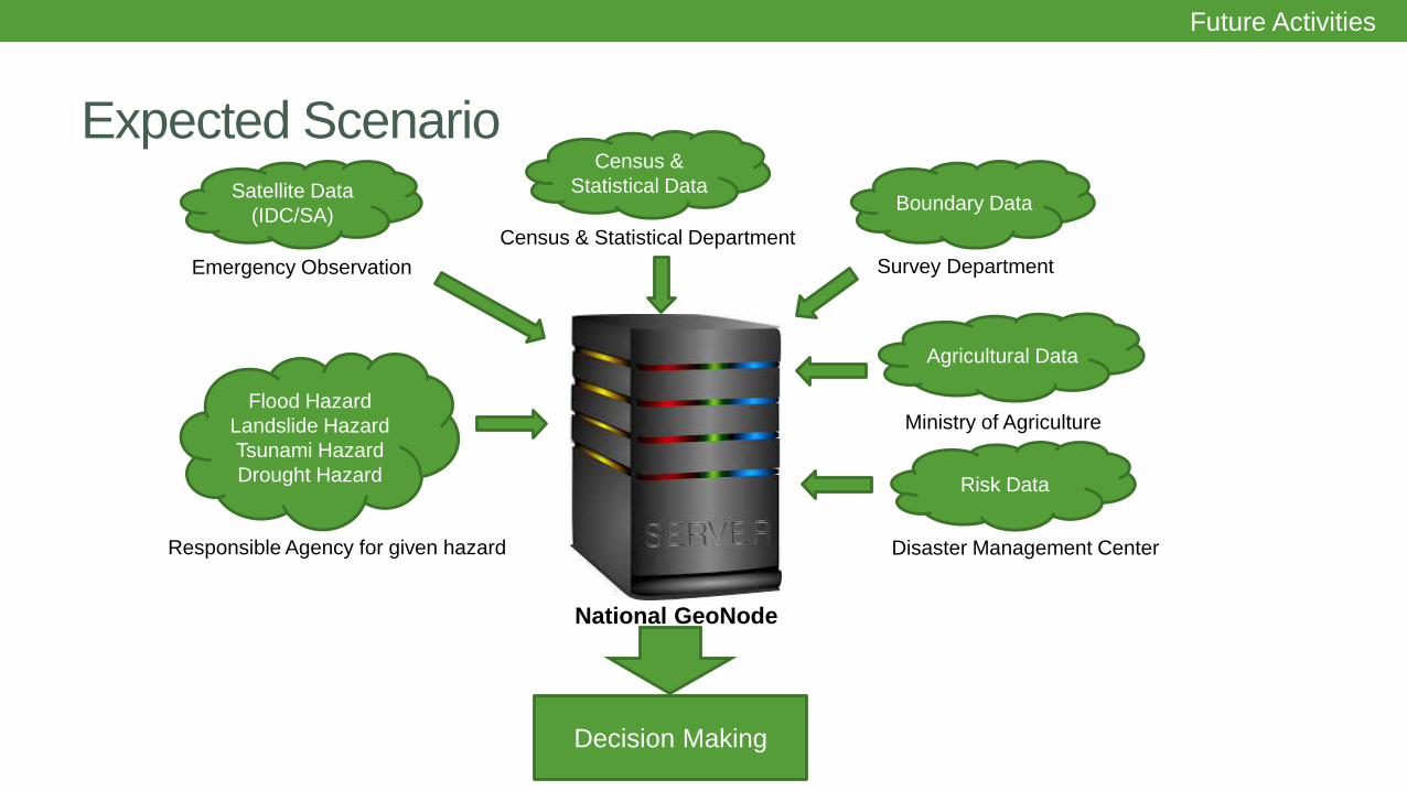
Expected Scenario
Future Activities
Satellite Data
(IDC/SA)
Emergency Observation
Census &
Statistical Data
Census & Statistical Department
Boundary Data
Survey Department
Flood Hazard
Landslide Hazard
Tsunami Hazard
Drought Hazard
Responsible Agency for given hazard
Agricultural Data
Ministry of Agriculture
Risk Data
Disaster Management Center
National GeoNode
Decision Making