A geo-referenced visual guide to 69 Chilean Volcanoes
45
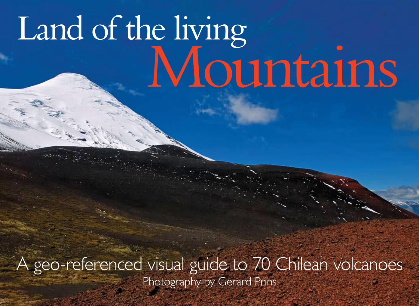
A geo-referenced visual guide to 70 Chilean volcanoes Photography by Gerard Prins Land of the living Mountains
-
Upload
gerard-prins -
Category
Travel
-
view
208 -
download
0
Transcript of A geo-referenced visual guide to 69 Chilean Volcanoes
A geo-referenced visual guide to 70 Chilean volcanoesPhotography by Gerard Prins
Land of the livingMountains
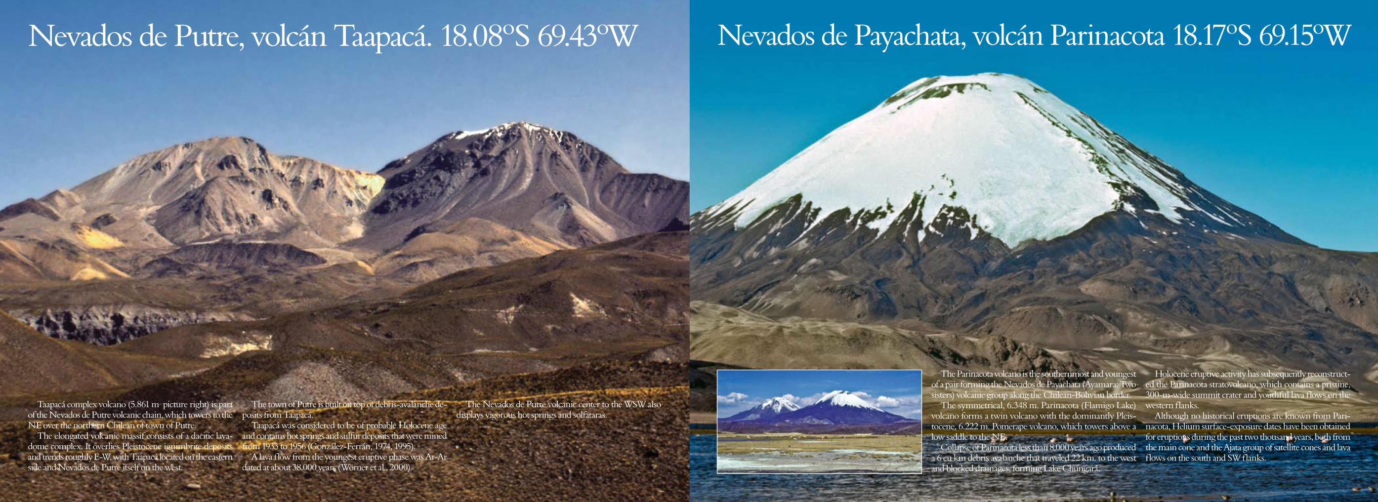
Taapacá complex volcano (5.861 m picture right) is part of the Nevados de Putre volcanic chain, which towers to the NE over the northern Chilean of town of Putre.
The elongated volcanic massif consists of a dacitic lava-dome complex. It overlies Pleistocene ignimbrite deposits and trends roughly E-W, with Taapacá located on the eastern side and Nevados de Putre itself on the west.
The town of Putre is built on top of debris-avalanche de-posits from Taapacá.
Taapacá was considered to be of probable Holocene age and contains hot springs and sulfur deposits that were mined from 1933 to 1956 (González-Ferrán, 1974, 1995).
A lava flow from the youngest eruptive phase was Ar-Ar dated at about 38.000 years (Wörner et al., 2000).
The Nevados de Putre volcanic center to the WSW also displays vigorous hot springs and solfataras.
Nevados de Putre, volcán Taapacá. 18.08ºS 69.43ºW
The Parinacota volcano is the southernmost and youngest of a pair forming the Nevados de Payachata (Ayamara: Two sisters) volcanic group along the Chilean-Bolivian border.
The symmetrical, 6.348 m. Parinacota (Flamigo Lake) volcano forms a twin volcano with the dominantly Pleis-tocene, 6.222 m. Pomerape volcano, which towers above a low saddle to the NE.
Collapse of Parinacota less than 8.000 years ago produced a 6 cu km debris avalanche that traveled 22 km. to the west and blocked drainages, forming Lake Chungará.
Holocene eruptive activity has subsequently reconstruct-ed the Parinacota stratovolcano, which contains a pristine, 300-m-wide summit crater and youthful lava flows on the western flanks.
Although no historical eruptions are known from Pari-nacota, Helium surface-exposure dates have been obtained for eruptions during the past two thousand years, both from the main cone and the Ajata group of satellite cones and lava flows on the south and SW flanks.
Nevados de Payachata, volcán Parinacota 18.17ºS 69.15ºW
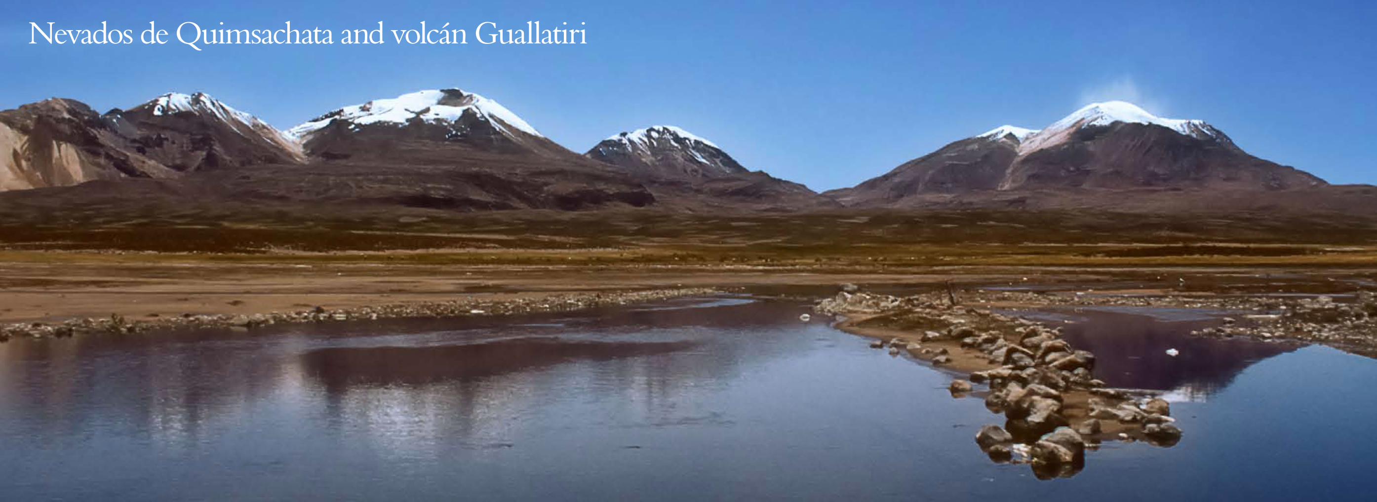
Nevados de Quimsachata and volcán Guallatiri
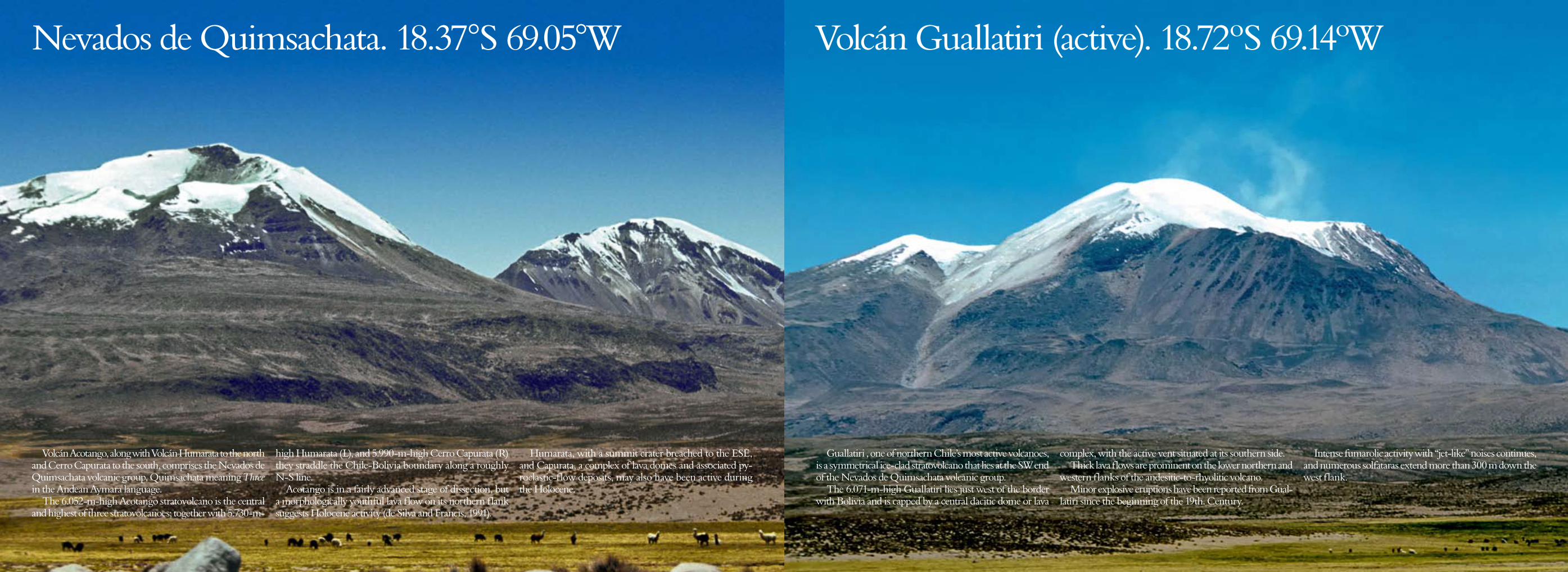
Volcán Acotango, along with Volcán Humarata to the north and Cerro Capurata to the south, comprises the Nevados de Quimsachata volcanic group, Quimsachata meaning Three in the Andean Aymara language.
The 6.052-m-high Acotango stratovolcano is the central and highest of three stratovolcanoes; together with 5.730-m-
high Humarata (L), and 5.990-m-high Cerro Capurata (R) they straddle the Chile-Bolivia boundary along a roughly N-S line.
Acotango is in a fairly advanced stage of dissection, but a morphologically youthful lava flow on its northern flank suggests Holocene activity (de Silva and Francis, 1991).
Humarata, with a summit crater breached to the ESE, and Capurata, a complex of lava domes and associated py-roclastic-flow deposits, may also have been active during the Holocene.
Volcán Guallatiri (active). 18.72ºS 69.14ºW
Guallatiri , one of northern Chile’s most active volcanoes, is a symmetrical ice-clad stratovolcano that lies at the SW end of the Nevados de Quimsachata volcanic group.
The 6.071-m-high Guallatiri lies just west of the border with Bolivia and is capped by a central dacitic dome or lava
complex, with the active vent situated at its southern side. Thick lava flows are prominent on the lower northern and
western flanks of the andesitic-to-rhyolitic volcano. Minor explosive eruptions have been reported from Gual-
latiri since the beginning of the 19th. Century.
Intense fumarolic activity with “jet-like” noises continues, and numerous solfataras extend more than 300 m down the west flank.
Nevados de Quimsachata. 18.37°S 69.05°W
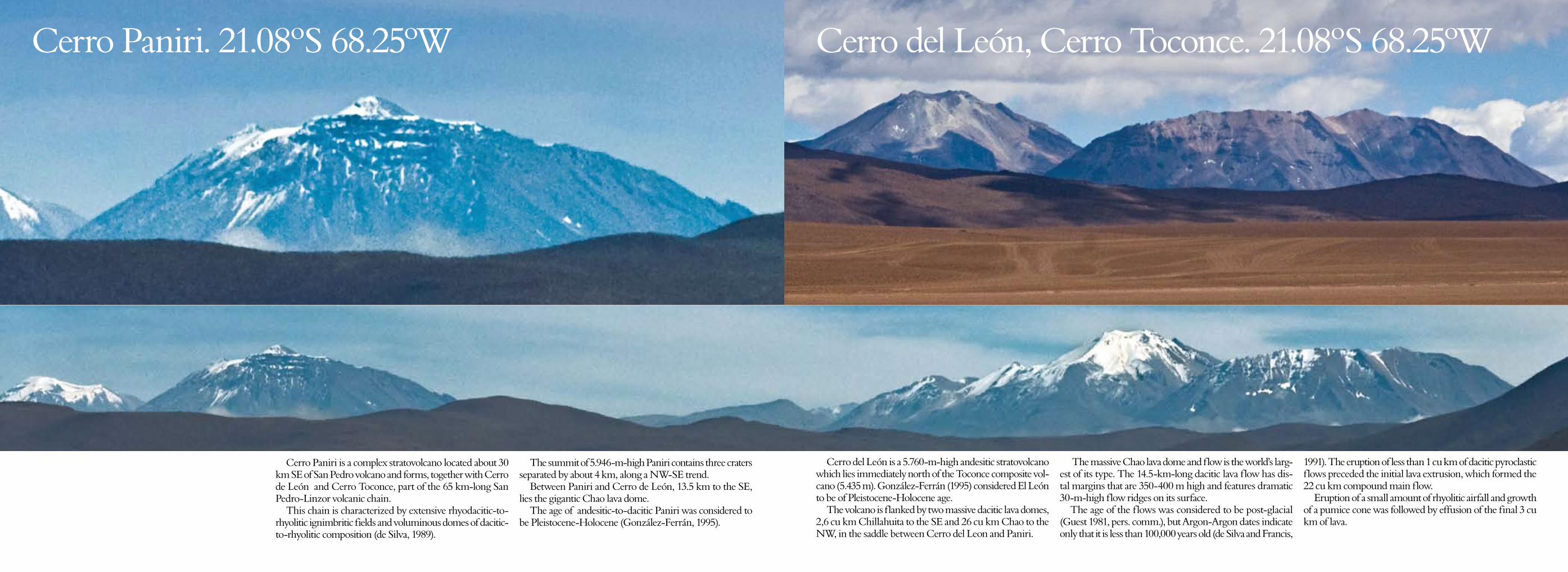
Cerro Paniri. 21.08ºS 68.25ºW Cerro del León, Cerro Toconce. 21.08ºS 68.25ºW
Cerro Paniri is a complex stratovolcano located about 30 km SE of San Pedro volcano and forms, together with Cerro de León and Cerro Toconce, part of the 65 km-long San Pedro-Linzor volcanic chain.
This chain is characterized by extensive rhyodacitic-to-rhyolitic ignimbritic fields and voluminous domes of dacitic-to-rhyolitic composition (de Silva, 1989).
The summit of 5.946-m-high Paniri contains three craters separated by about 4 km, along a NW-SE trend.
Between Paniri and Cerro de León, 13.5 km to the SE, lies the gigantic Chao lava dome.
The age of andesitic-to-dacitic Paniri was considered to be Pleistocene-Holocene (González-Ferrán, 1995).
Cerro del León is a 5.760-m-high andesitic stratovolcano which lies immediately north of the Toconce composite vol-cano (5.435 m). González-Ferrán (1995) considered El León to be of Pleistocene-Holocene age.
The volcano is flanked by two massive dacitic lava domes, 2,6 cu km Chillahuita to the SE and 26 cu km Chao to the NW, in the saddle between Cerro del Leon and Paniri.
The massive Chao lava dome and flow is the world’s larg-est of its type. The 14.5-km-long dacitic lava flow has dis-tal margins that are 350-400 m high and features dramatic 30-m-high flow ridges on its surface.
The age of the flows was considered to be post-glacial (Guest 1981, pers. comm.), but Argon-Argon dates indicate only that it is less than 100,000 years old (de Silva and Francis,
1991). The eruption of less than 1 cu km of dacitic pyroclastic flows preceded the initial lava extrusion, which formed the 22 cu km compound main flow.
Eruption of a small amount of rhyolitic airfall and growth of a pumice cone was followed by effusion of the final 3 cu km of lava.
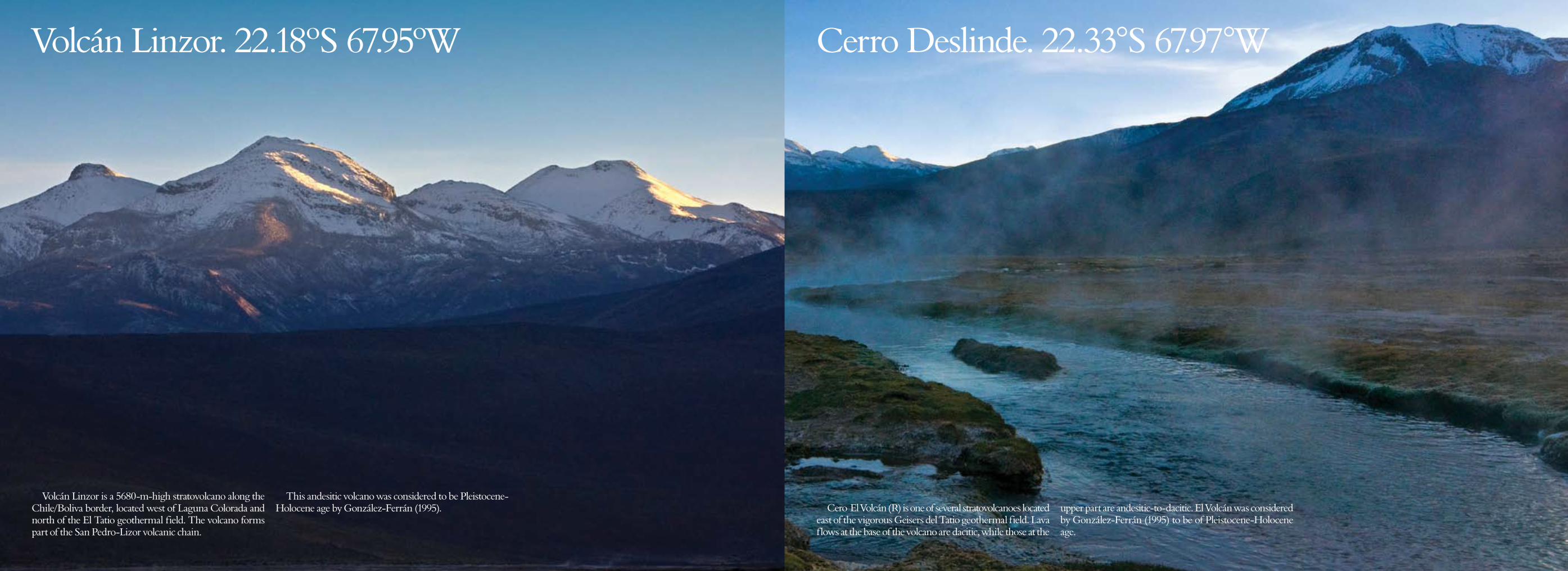
Volcán Linzor. 22.18ºS 67.95ºW Cerro Deslinde. 22.33°S 67.97°W
Volcán Linzor is a 5680-m-high stratovolcano along the Chile/Boliva border, located west of Laguna Colorada and north of the El Tatio geothermal field. The volcano forms part of the San Pedro-Lizor volcanic chain.
This andesitic volcano was considered to be Pleistocene-Holocene age by González-Ferrán (1995). Cero El Volcán (R) is one of several stratovolcanoes located
east of the vigorous Geisers del Tatio geothermal field. Lava flows at the base of the volcano are dacitic, while those at the
upper part are andesitic-to-dacitic. El Volcán was considered by González-Ferrán (1995) to be of Pleistocene-Holocene age.
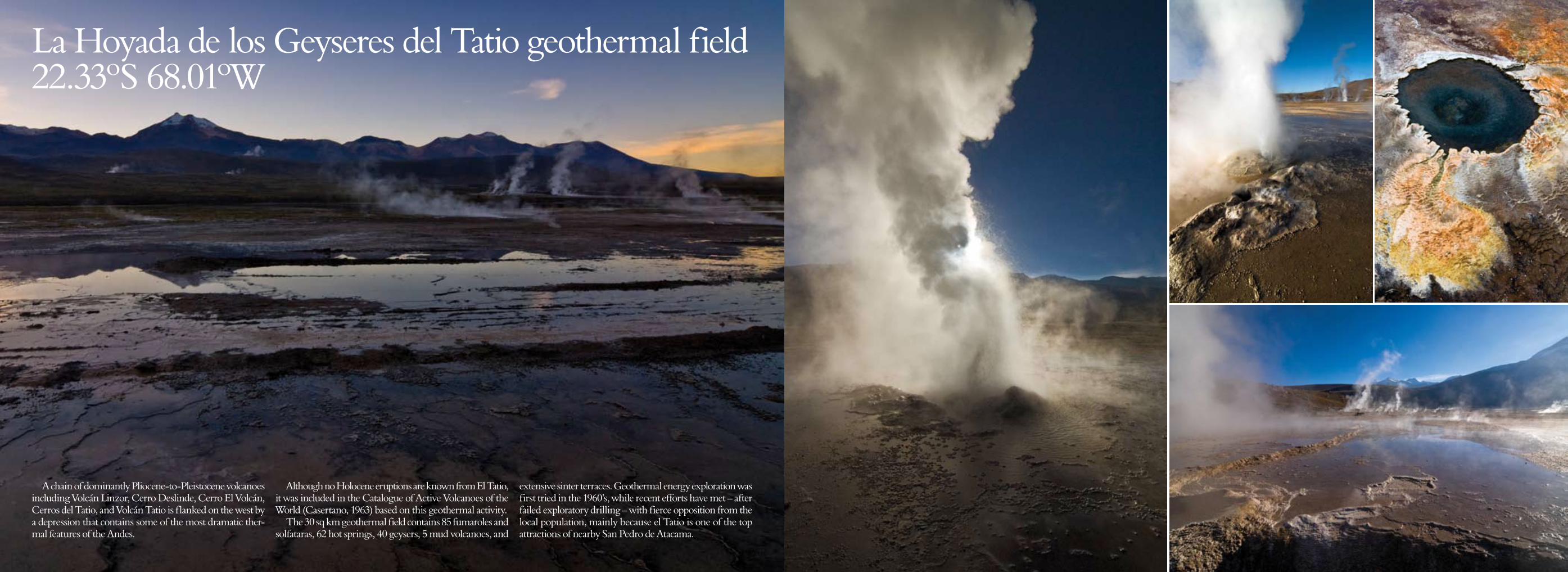
La Hoyada de los Geyseres del Tatio geothermal field 22.33ºS 68.01ºW
A chain of dominantly Pliocene-to-Pleistocene volcanoes including Volcán Linzor, Cerro Deslinde, Cerro El Volcán, Cerros del Tatio, and Volcán Tatio is flanked on the west by a depression that contains some of the most dramatic ther-mal features of the Andes.
Although no Holocene eruptions are known from El Tatio, it was included in the Catalogue of Active Volcanoes of the World (Casertano, 1963) based on this geothermal activity.
The 30 sq km geothermal field contains 85 fumaroles and solfataras, 62 hot springs, 40 geysers, 5 mud volcanoes, and
extensive sinter terraces. Geothermal energy exploration was first tried in the 1960’s, while recent efforts have met – after failed exploratory drilling – with fierce opposition from the local population, mainly because el Tatio is one of the top attractions of nearby San Pedro de Atacama.
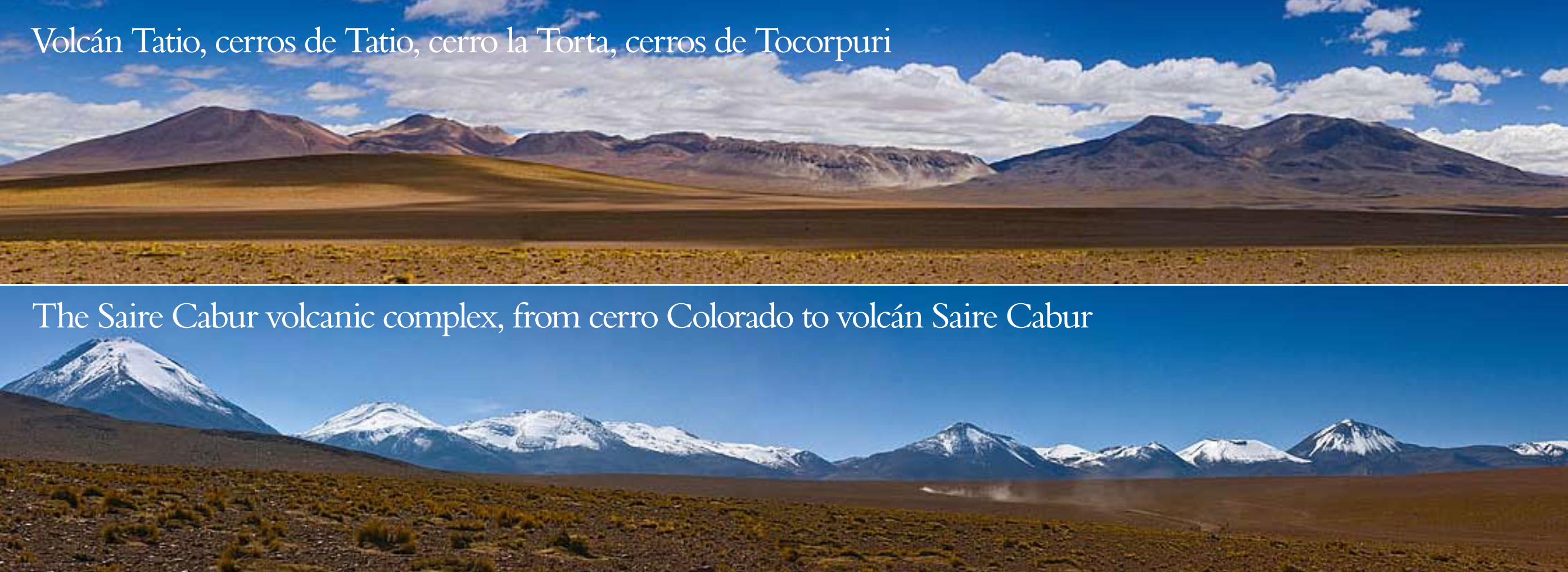
Volcán Tatio, cerros de Tatio, cerro la Torta, cerros de Tocorpuri
The Saire Cabur volcanic complex, from cerro Colorado to volcán Saire Cabur
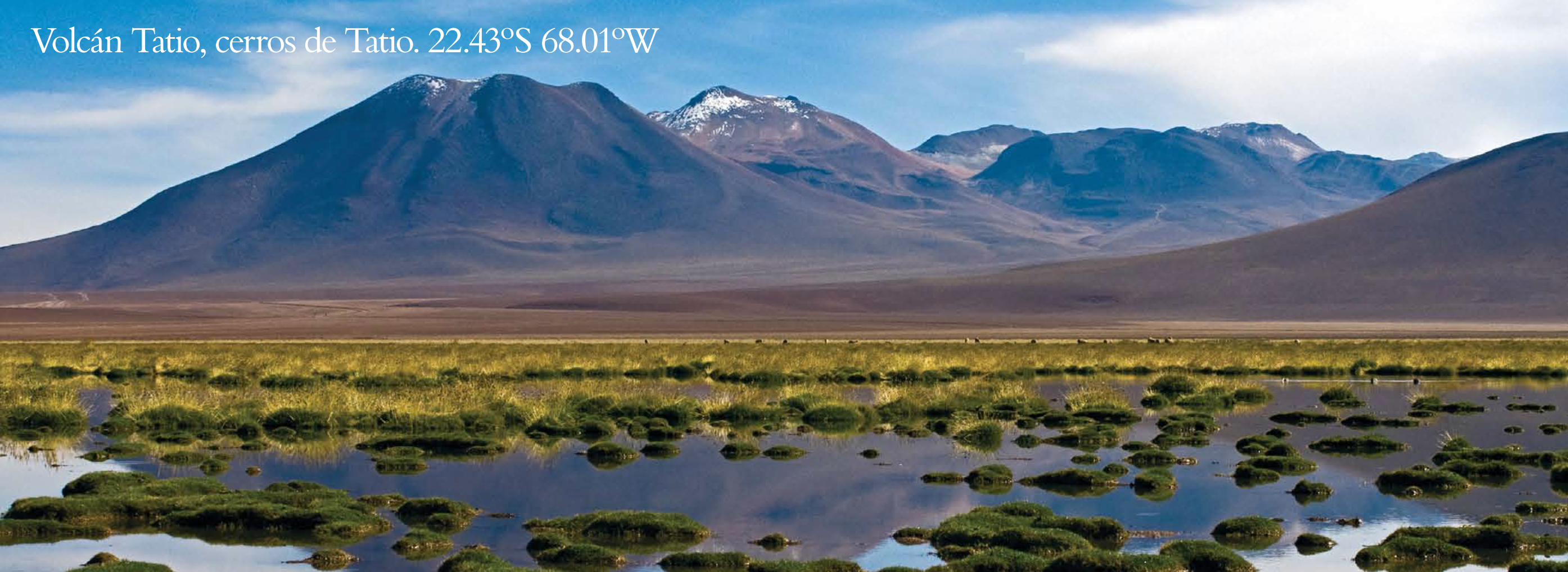
Volcán Tatio, cerros de Tatio. 22.43ºS 68.01ºW
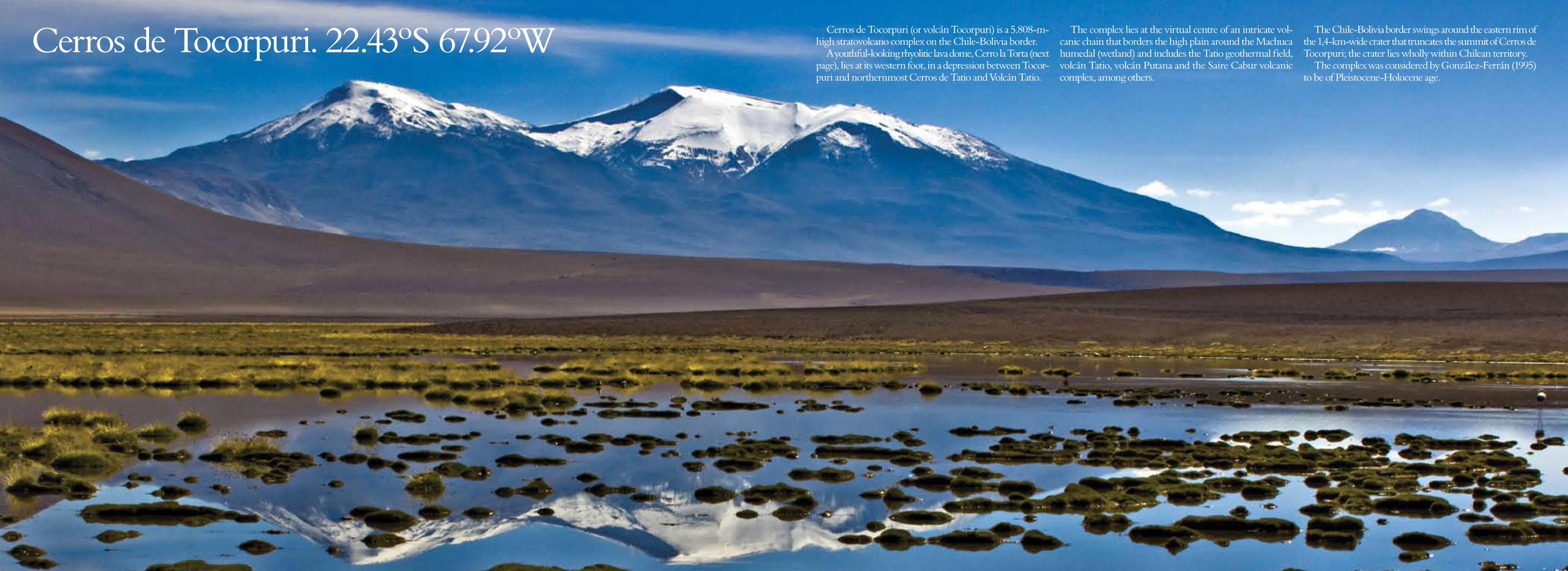
Cerros de Tocorpuri. 22.43ºS 67.92ºW Cerros de Tocorpuri (or volcán Tocorpuri) is a 5.808-m-high stratovolcano complex on the Chile-Bolivia border.
A youthful-looking rhyolitic lava dome, Cerro la Torta (next page), lies at its western foot, in a depression between Tocor-puri and northernmost Cerros de Tatio and Volcán Tatio.
The complex lies at the virtual centre of an intricate vol-canic chain that borders the high plain around the Machuca humedal (wetland) and includes the Tatio geothermal field, volcán Tatio, volcán Putana and the Saire Cabur volcanic complex, among others.
The Chile-Bolivia border swings around the eastern rim of the 1,4-km-wide crater that truncates the summit of Cerros de Tocorpuri; the crater lies wholly within Chilean territory.
The complex was considered by González-Ferrán (1995) to be of Pleistocene-Holocene age.
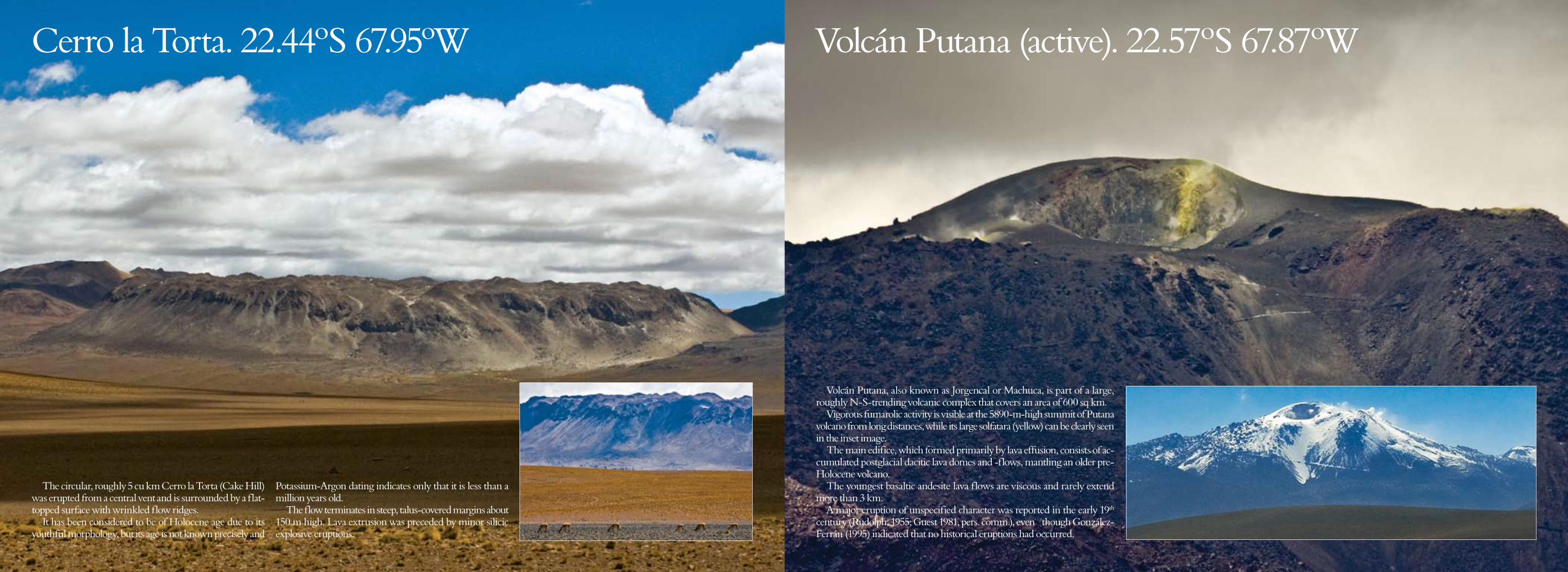
The circular, roughly 5 cu km Cerro la Torta (Cake Hill) was erupted from a central vent and is surrounded by a flat-topped surface with wrinkled flow ridges.
It has been considered to be of Holocene age due to its youthful morphology, but its age is not known precisely and
Potassium-Argon dating indicates only that it is less than a million years old.
The flow terminates in steep, talus-covered margins about 150 m high. Lava extrusion was preceded by minor silicic explosive eruptions.
Cerro la Torta. 22.44ºS 67.95ºW Volcán Putana (active). 22.57ºS 67.87ºW
Volcán Putana, also known as Jorgencal or Machuca, is part of a large, roughly N-S-trending volcanic complex that covers an area of 600 sq km.
Vigorous fumarolic activity is visible at the 5890-m-high summit of Putana volcano from long distances, while its large solfatara (yellow) can be clearly seen in the inset image.
The main edifice, which formed primarily by lava effusion, consists of ac-cumulated postglacial dacitic lava domes and -flows, mantling an older pre-Holocene volcano.
The youngest basaltic andesite lava flows are viscous and rarely extend more than 3 km.
A major eruption of unspecified character was reported in the early 19th century (Rudolph, 1955; Guest 1981, pers. comm.), even though González-Ferrán (1995) indicated that no historical eruptions had occurred.
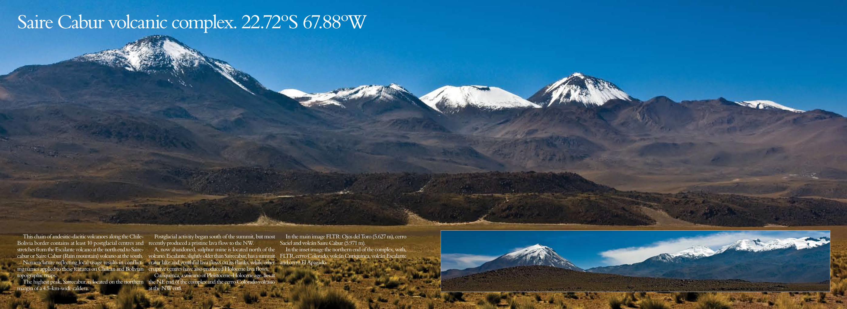
Saire Cabur volcanic complex. 22.72ºS 67.88ºW
This chain of andesitic-dacitic volcanoes along the Chile-Bolivia border contains at least 10 postglacial centres and stretches from the Escalante volcano at the north end to Saire-cabur or Saire Cabur (Rain mountain) volcano at the south.
Nomenclature reflecting local usage results in conflict-ing names applied to these features on Chilean and Bolivian topographic maps.
The highest peak, Sairecabur, is located on the northern margin of a 4.5-km-wide caldera.
Postglacial activity began south of the summit, but most recently produced a pristine lava flow to the NW.
A, now abandoned, sulphur mine is located north of the volcano. Escalante, slightly older than Sairecabur, has a summit crater lake and youthful lava flows on its flanks, while other eruptive centres have also produced Holocene lava flows.
Curiquinca, a volcano of Pleistocene-Holocene age, lies at the NE end of the complex and the cerro Colorado volcano at the NW end.
In the main image FLTR: Ojos del Toro (5.627 m), cerro Saciel and volcán Saire Cabur (5.971 m).
In the inset image the northern end of the complex, with, FLTR, cerro Colorado, volcán Curiquinca, volcán Escalante and cerro El Apagado.
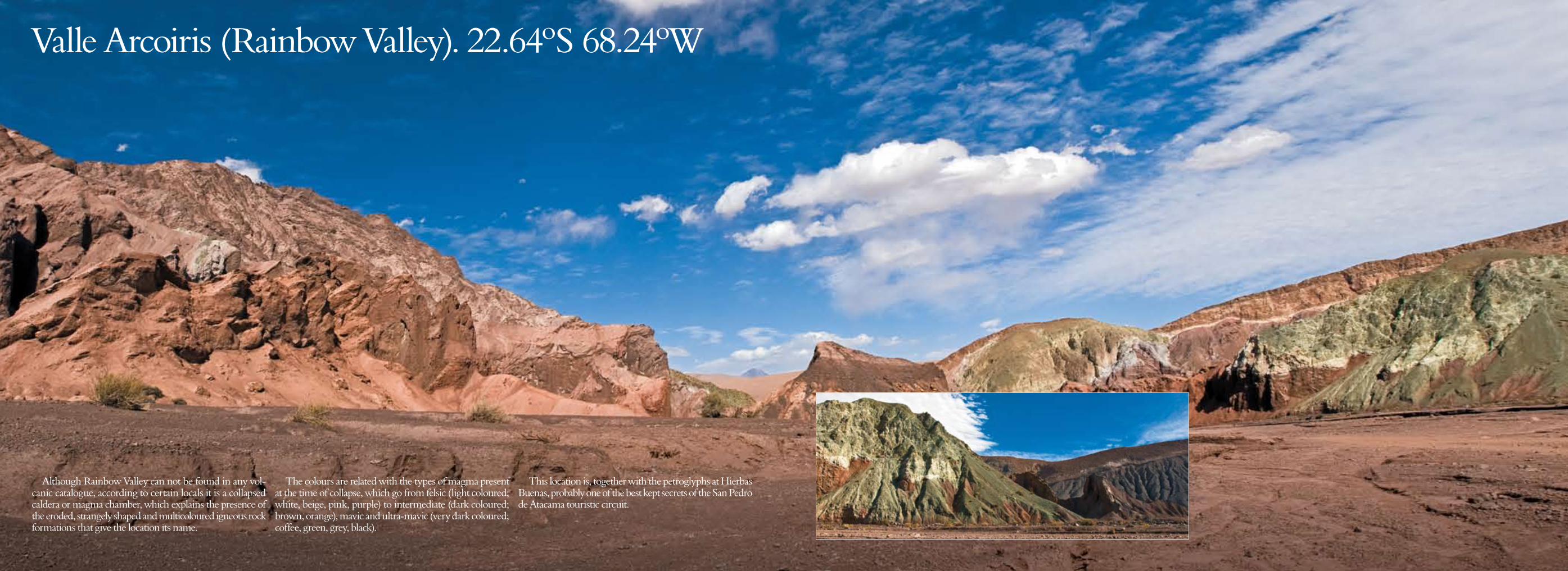
Valle Arcoiris (Rainbow Valley). 22.64ºS 68.24ºW
Although Rainbow Valley can not be found in any vol-canic catalogue, according to certain locals it is a collapsed caldera or magma chamber, which explains the presence of the eroded, strangely shaped and multicoloured igneous rock formations that give the location its name.
The colours are related with the types of magma present at the time of collapse, which go from felsic (light coloured; white, beige, pink, purple) to intermediate (dark coloured; brown, orange), mavic and ultra-mavic (very dark coloured; coffee, green, grey, black).
This location is, together with the petroglyphs at Hierbas Buenas, probably one of the best kept secrets of the San Pedro de Atacama touristic circuit.
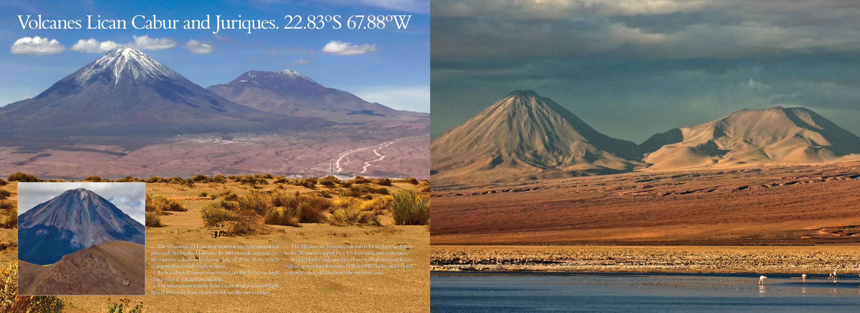
Volcanes Lican Cabur and Juriques. 22.83ºS 67.88ºW
The symmetrical Licancabur stratovolcano was constructed primarily during the Holocene. Its 400-m-wide summit cra-ter contains a shallow freshwater lake of 90 by 70 m., which is among the world’s highest lakes.
Archaeological ruins were found on the 5.916-m-high crater rim of volcán Lincancabur.
The most recent activity from Licancabur produced flank lava flows., which are clearly visible on the inset image.
The Pleistocene Juriques volcano is located immediately to the SE and is capped by a 1.5-km-wide summit crater.
Young blocky andesitic lava flows with prominent levees extend up to 6 km down the NW-to-SW flanks; older flows extend to up to 12 km from the summit crater.
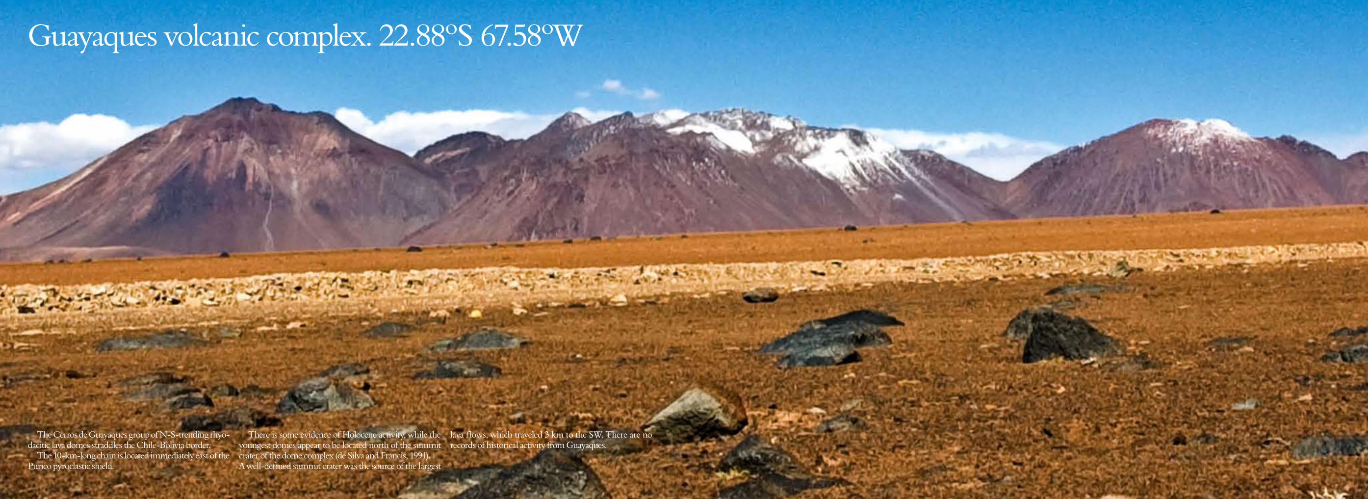
Guayaques volcanic complex. 22.88ºS 67.58ºW
The Cerros de Guayaques group of N-S-trending rhyo-dacitic lava domes straddles the Chile-Bolivia border.
The 10-km-long chain is located immediately east of the Purico pyroclastic shield.
There is some evidence of Holocene activity, while the youngest domes appear to be located north of the summit crater of the dome complex (de Silva and Francis, 1991). A well-defined summit crater was the source of the largest
lava flows, which traveled 3 km to the SW. There are no records of historical activity from Guayaques.
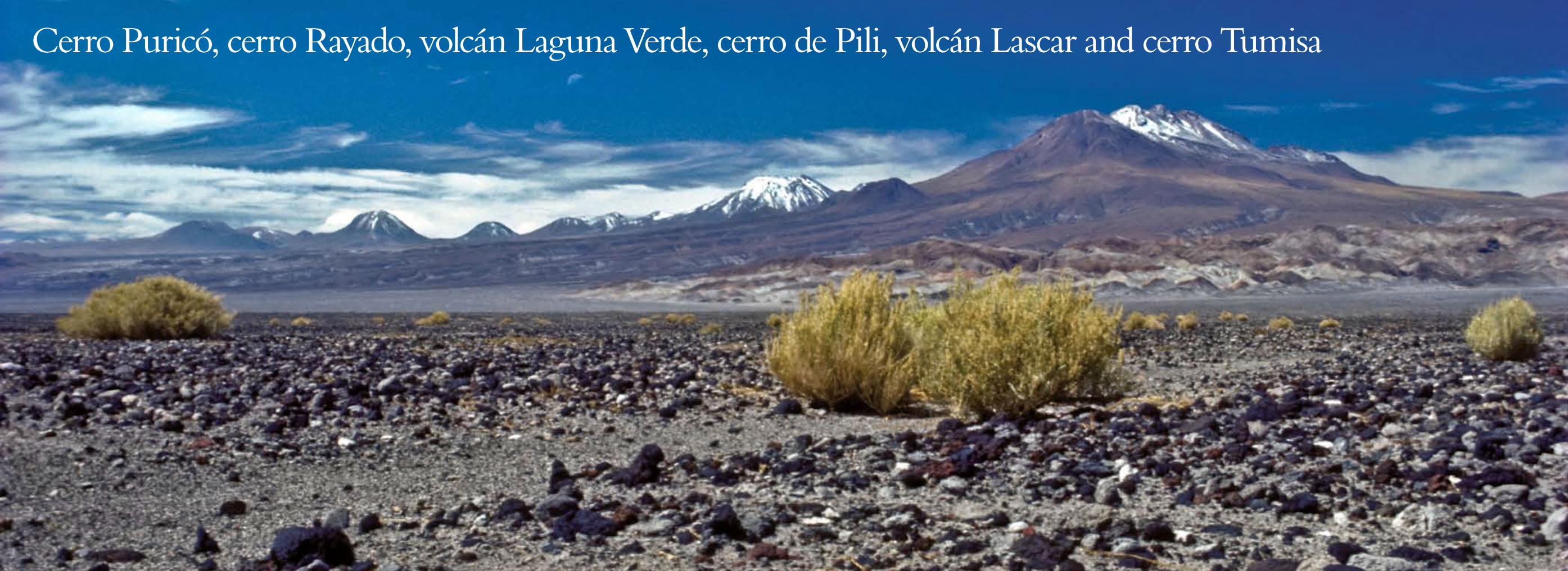
Cerro Puricó, cerro Rayado, volcán Laguna Verde, cerro de Pili, volcán Lascar and cerro Tumisa
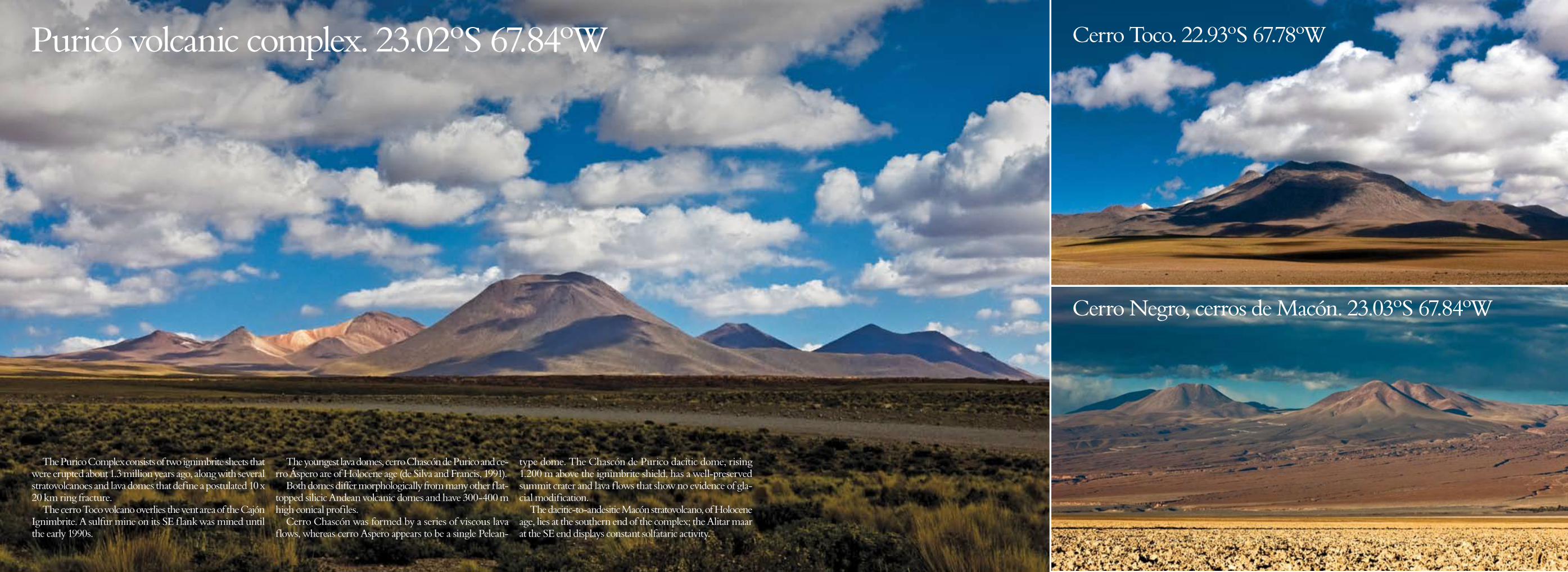
The Purico Complex consists of two ignimbrite sheets that were erupted about 1.3 million years ago, along with several stratovolcanoes and lava domes that define a postulated 10 x 20 km ring fracture.
The cerro Toco volcano overlies the vent area of the Cajón Ignimbrite. A sulfur mine on its SE flank was mined until the early 1990s.
The youngest lava domes, cerro Chascón de Purico and ce-rro Áspero are of Holocene age (de Silva and Francis, 1991).
Both domes differ morphologically from many other flat-topped silicic Andean volcanic domes and have 300-400 m high conical profiles.
Cerro Chascón was formed by a series of viscous lava flows, whereas cerro Aspero appears to be a single Pelean-
type dome. The Chascón de Purico dacitic dome, rising 1.200 m above the ignimbrite shield, has a well-preserved summit crater and lava flows that show no evidence of gla-cial modification.
The dacitic-to-andesitic Macón stratovolcano, of Holocene age, lies at the southern end of the complex; the Alitar maar at the SE end displays constant solfataric activity.
Cerro Negro, cerros de Macón. 23.03ºS 67.84ºW
Cerro Toco. 22.93ºS 67.78ºW Puricó volcanic complex. 23.02ºS 67.84ºW

Volcán Laguna Verde. 23.25º S 67.72º W The Atacama desert volcanic chain
Laguna Verde is a 5.464-m-high stratovolcano located west of Colachi volcano and is one of a cluster of young stratovol-canoes north and east of the Lascar volcano.
The Laguna Verde volcano was considered to be of Pleis-tocene-Holocene age (González-Ferrán, 1995). The andesitic volcano, rising 1200 m above its base, collapsed
to the north, producing a debris avalanche that dammed the Quebrada Portor, forming a lake.
Part of the Atacama desert chain of volcanoes, seen from the high plain (± 3.000 m). Virtually every mountain in this image – covering a 165-km stretch that runs from volcán
Curiquica to cerro Tumisa – is a volcano or, at least, an ex-pression of the geological events that are the product of the subduction of the Nazca- under the South American Plate.
Note the fumarole emanating from the Lascar volcano at the centre of the image, which is just one visual benchmark of an area that is marked by intense volcanic activity.
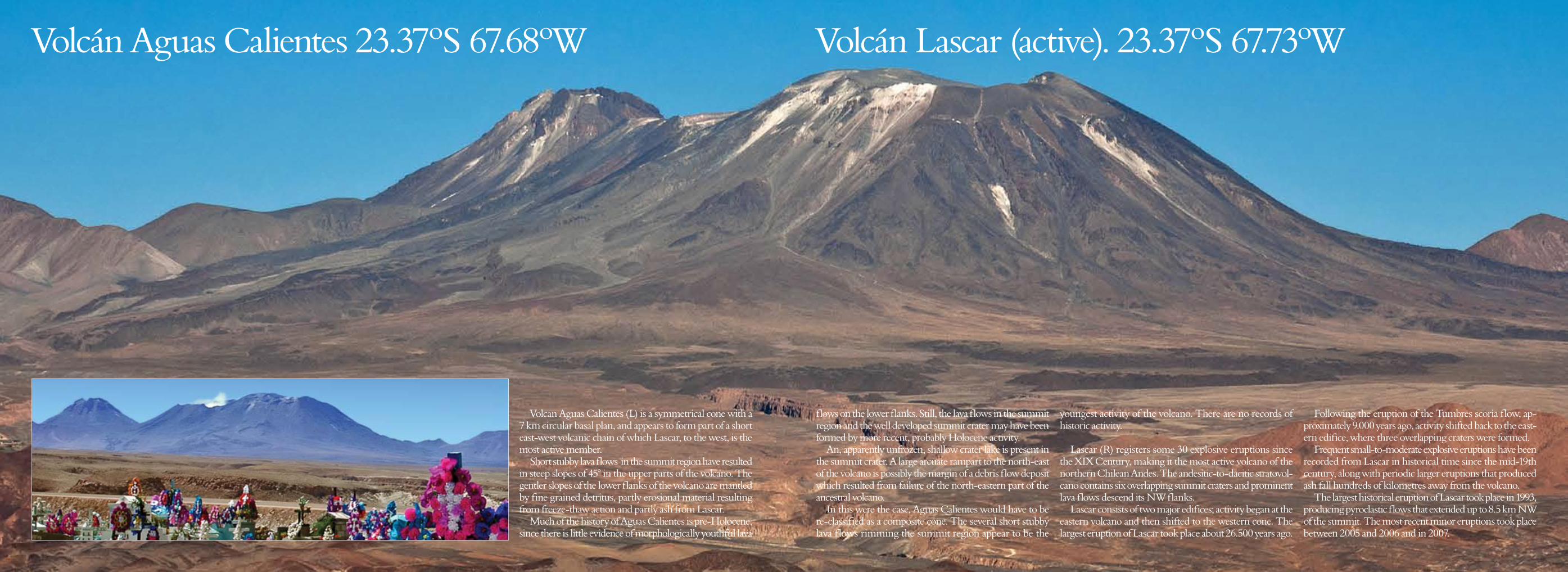
Volcán Aguas Calientes 23.37ºS 67.68ºW Volcán Lascar (active). 23.37ºS 67.73ºW
Volcan Aguas Calientes (L) is a symmetrical cone with a 7 km circular basal plan, and appears to form part of a short east-west volcanic chain of which Lascar, to the west, is the most active member.
Short stubby lava flows in the summit region have resulted in steep slopes of 45° in the upper parts of the volcano. The gentler slopes of the lower flanks of the volcano are mantled by fine grained detritus, partly erosional material resulting from freeze-thaw action and partly ash from Lascar.
Much of the history of Aguas Calientes is pre-Holocene, since there is little evidence of morphologically youthful lava
flows on the lower flanks. Still, the lava flows in the summit region and the well developed summit crater may have been formed by more recent, probably Holocene activity.
An, apparently unfrozen, shallow crater lake is present in the summit crater. A large arcuate rampart to the north-east of the volcano is possibly the margin of a debris flow deposit which resulted from failure of the north-eastern part of the ancestral volcano.
In this were the case, Aguas Calientes would have to be re-classified as a composite cone. The several short stubby lava flows rimming the summit region appear to be the
youngest activity of the volcano. There are no records of historic activity.
Lascar (R) registers some 30 explosive eruptions since the XIX Century, making it the most active volcano of the northern Chilean Andes. The andesitic-to-dacitic stratovol-cano contains six overlapping summit craters and prominent lava flows descend its NW flanks.
Lascar consists of two major edifices; activity began at the eastern volcano and then shifted to the western cone. The largest eruption of Lascar took place about 26.500 years ago.
Following the eruption of the Tumbres scoria flow, ap-proximately 9.000 years ago, activity shifted back to the east-ern edifice, where three overlapping craters were formed.
Frequent small-to-moderate explosive eruptions have been recorded from Lascar in historical time since the mid-19th century, along with periodic larger eruptions that produced ash fall hundreds of kilometres away from the volcano.
The largest historical eruption of Lascar took place in 1993, producing pyroclastic flows that extended up to 8.5 km NW of the summit. The most recent minor eruptions took place between 2005 and 2006 and in 2007.
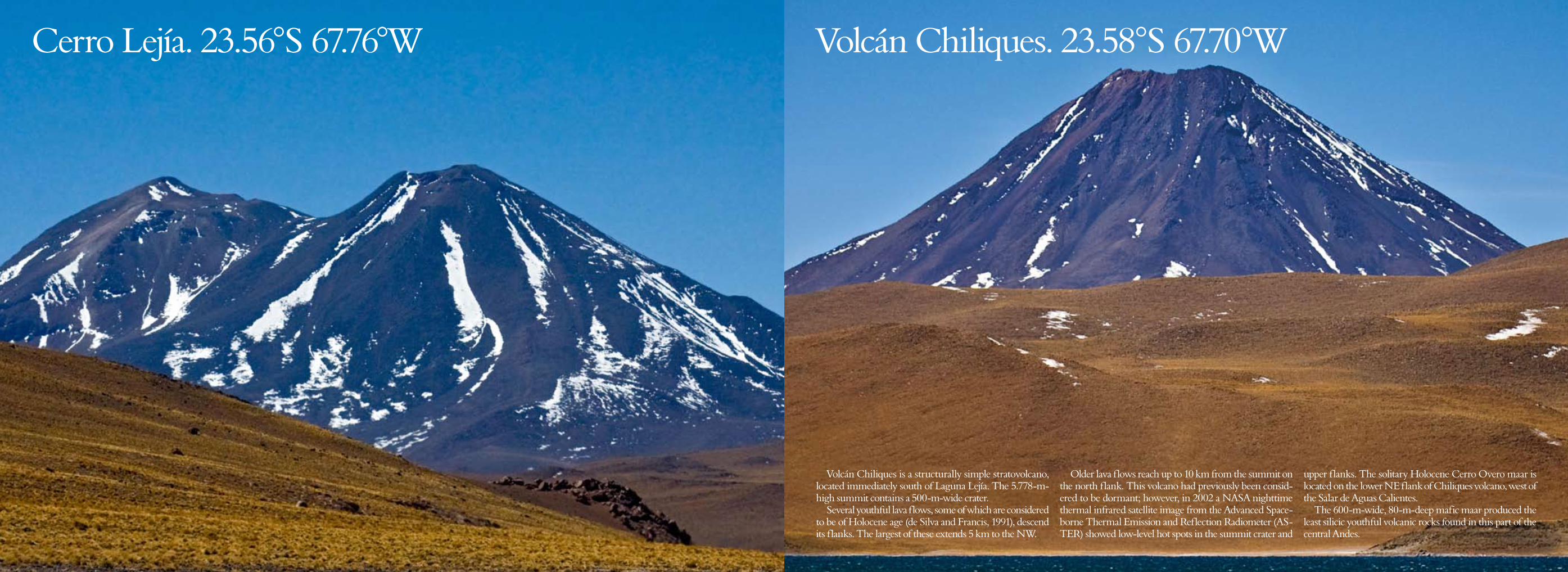
Volcán Chiliques. 23.58°S 67.70°W Cerro Lejía. 23.56°S 67.76°W
Volcán Chiliques is a structurally simple stratovolcano, located immediately south of Laguna Lejía. The 5.778-m-high summit contains a 500-m-wide crater.
Several youthful lava flows, some of which are considered to be of Holocene age (de Silva and Francis, 1991), descend its flanks. The largest of these extends 5 km to the NW.
Older lava flows reach up to 10 km from the summit on the north flank. This volcano had previously been consid-ered to be dormant; however, in 2002 a NASA nighttime thermal infrared satellite image from the Advanced Space-borne Thermal Emission and Reflection Radiometer (AS-TER) showed low-level hot spots in the summit crater and
upper flanks. The solitary Holocene Cerro Overo maar is located on the lower NE flank of Chiliques volcano, west of the Salar de Aguas Calientes.
The 600-m-wide, 80-m-deep mafic maar produced the least silicic youthful volcanic rocks found in this part of the central Andes.
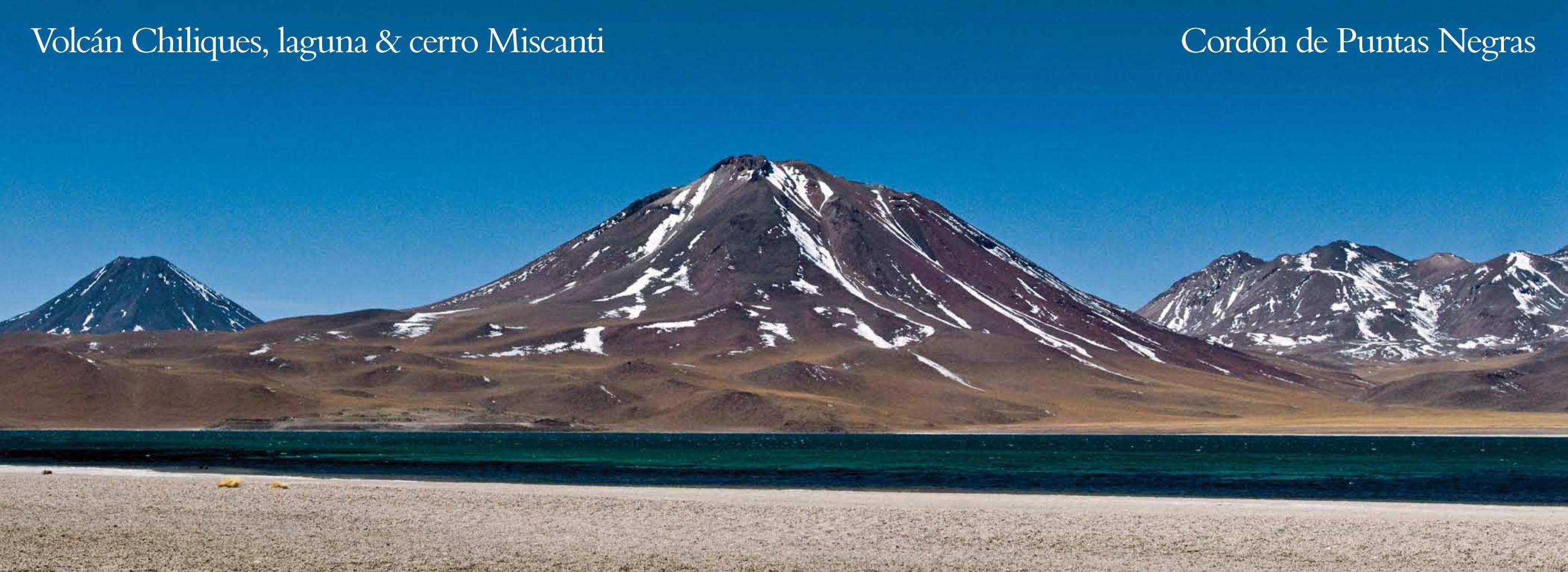
Volcán Chiliques, laguna & cerro Miscanti Cordón de Puntas Negras
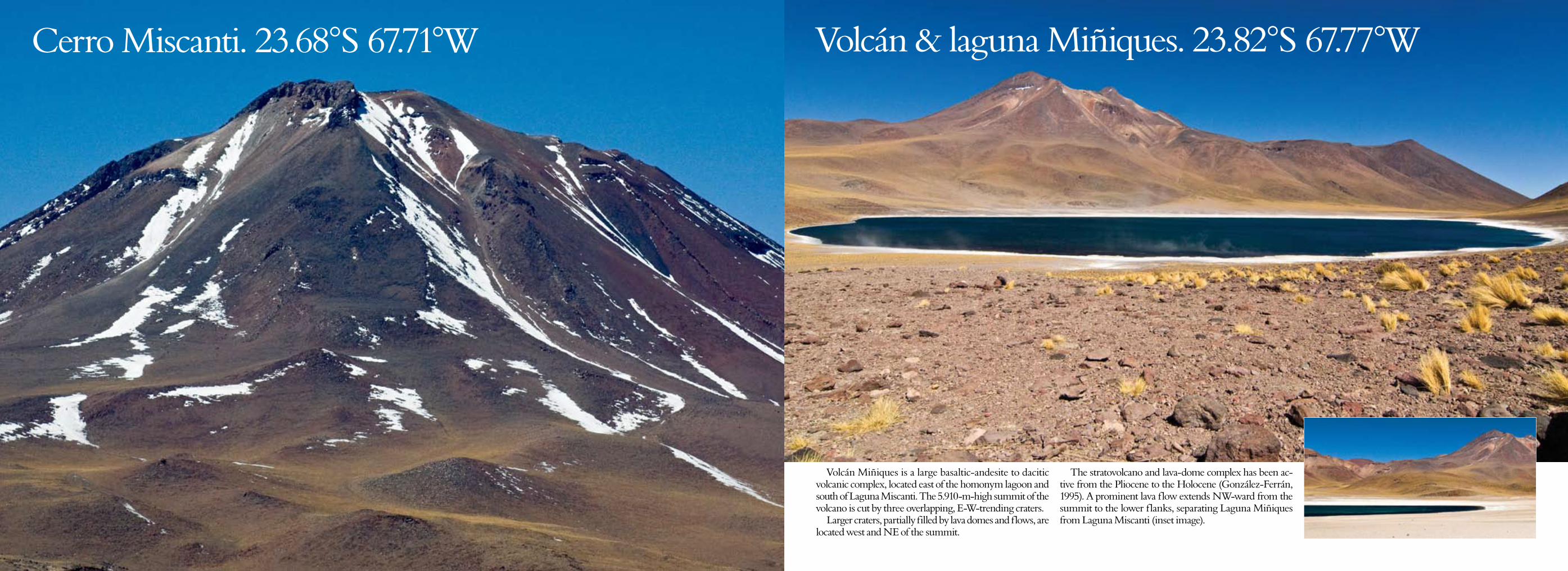
Volcán & laguna Miñiques. 23.82°S 67.77°W
Volcán Miñiques is a large basaltic-andesite to dacitic volcanic complex, located east of the homonym lagoon and south of Laguna Miscanti. The 5.910-m-high summit of the volcano is cut by three overlapping, E-W-trending craters.
Larger craters, partially filled by lava domes and flows, are located west and NE of the summit.
The stratovolcano and lava-dome complex has been ac-tive from the Pliocene to the Holocene (González-Ferrán, 1995). A prominent lava flow extends NW-ward from the summit to the lower flanks, separating Laguna Miñiques from Laguna Miscanti (inset image).
Cerro Miscanti. 23.68°S 67.71°W
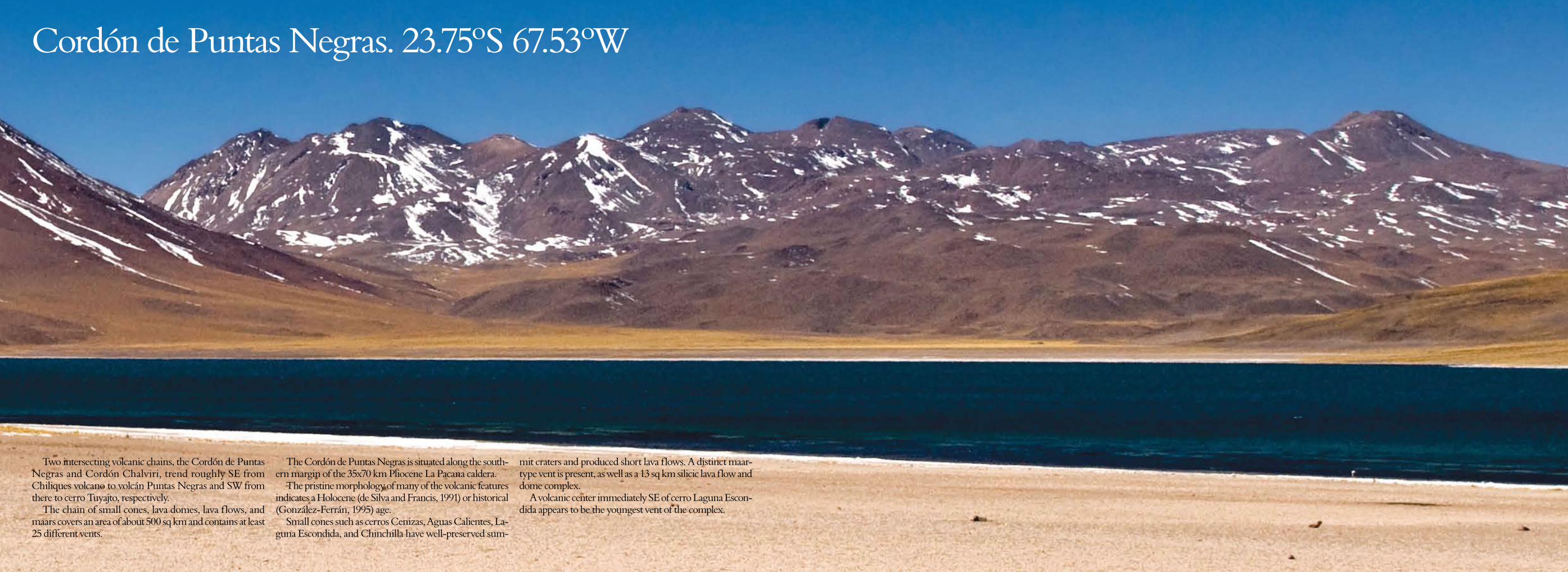
Cordón de Puntas Negras. 23.75ºS 67.53ºW
Two intersecting volcanic chains, the Cordón de Puntas Negras and Cordón Chalviri, trend roughly SE from Chiliques volcano to volcán Puntas Negras and SW from there to cerro Tuyajto, respectively.
The chain of small cones, lava domes, lava flows, and maars covers an area of about 500 sq km and contains at least 25 different vents.
The Cordón de Puntas Negras is situated along the south-ern margin of the 35x70 km Pliocene La Pacana caldera.
The pristine morphology of many of the volcanic features indicates a Holocene (de Silva and Francis, 1991) or historical (González-Ferrán, 1995) age.
Small cones such as cerros Cenizas, Aguas Calientes, La-guna Escondida, and Chinchilla have well-preserved sum-
mit craters and produced short lava flows. A distinct maar-type vent is present, as well as a 13 sq km silicic lava flow and dome complex.
A volcanic center immediately SE of cerro Laguna Escon-dida appears to be the youngest vent of the complex.
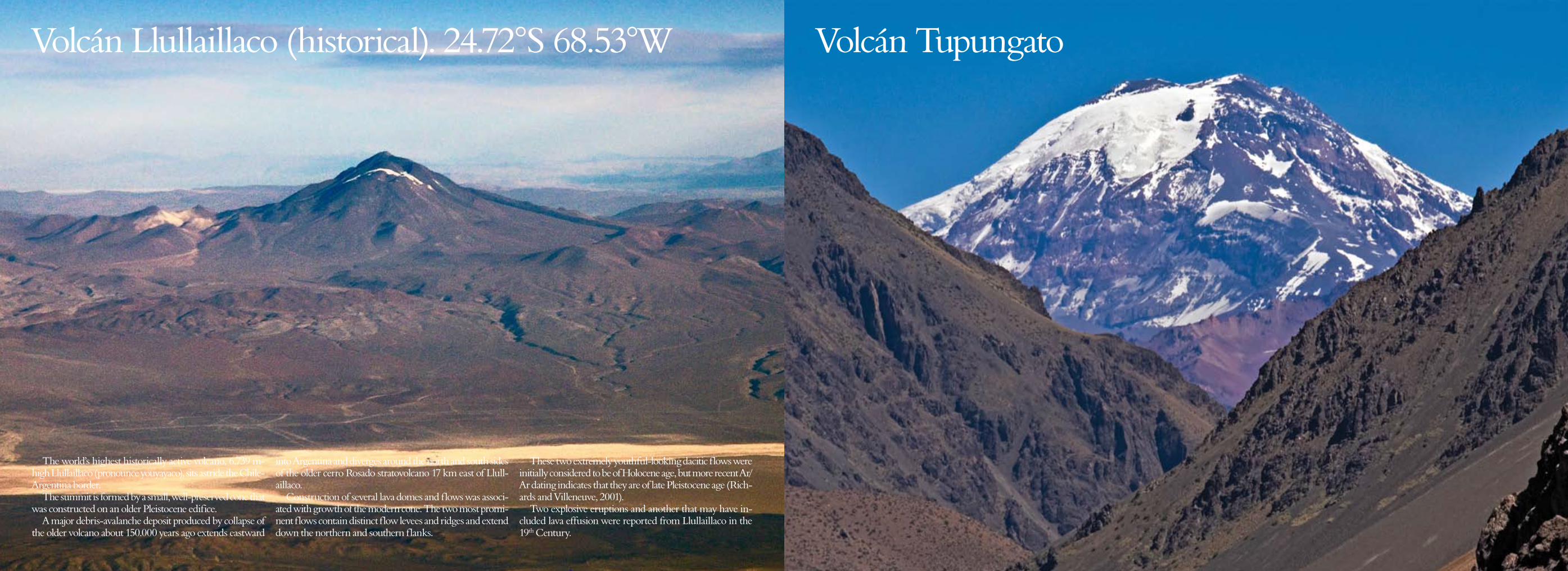
Volcán Llullaillaco (historical). 24.72°S 68.53°W
The world’s highest historically active volcano, 6.739 m-high Llullaillaco (pronounce youyayaco), sits astride the Chile-Argentina border.
The summit is formed by a small, well-preserved cone that was constructed on an older Pleistocene edifice.
A major debris-avalanche deposit produced by collapse of the older volcano about 150.000 years ago extends eastward
into Argentina and diverges around the north and south sides of the older cerro Rosado stratovolcano 17 km east of Llull-aillaco.
Construction of several lava domes and flows was associ-ated with growth of the modern cone. The two most promi-nent flows contain distinct flow levees and ridges and extend down the northern and southern flanks.
These two extremely youthful-looking dacitic flows were initially considered to be of Holocene age, but more recent Ar/Ar dating indicates that they are of late Pleistocene age (Rich-ards and Villeneuve, 2001).
Two explosive eruptions and another that may have in-cluded lava effusion were reported from Llullaillaco in the 19th Century.
Volcanes Tupungato, Tupungatito (historical). 33.40°S 69.80°WVolcán Tupungato
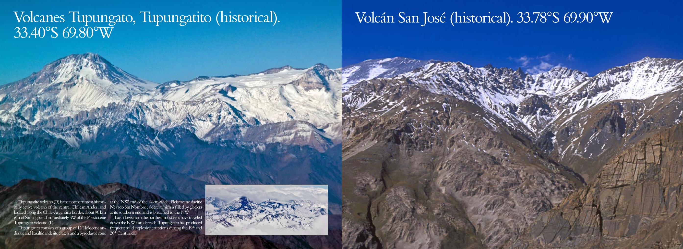
Volcanes Tupungato, Tupungatito (historical). 33.40°S 69.80°W
Tupungatito volcano (R) is the northernmost histori-cally active volcano of the central Chilean Andes, and located along the Chile-Argentina border, about 90 km east of Santiago and immediately SW of the Pleistocene Tupungato volcano (L).
Tupungatito consists of a group of 12 Holocene an-desitic and basaltic andesite craters and a pyroclastic cone
at the NW end of the 4-km-wide, Pleistocene dacitic Nevado Sin Nombre caldera, which is filled by glaciers at its southern end and is breached to the NW.
Lava flows from the northernmost vent have traveled down the NW flank breach. Tupungatito has produced frequent mild explosive eruptions during the 19th and 20th Centuries.
Volcán San José (historical). 33.78°S 69.90°W
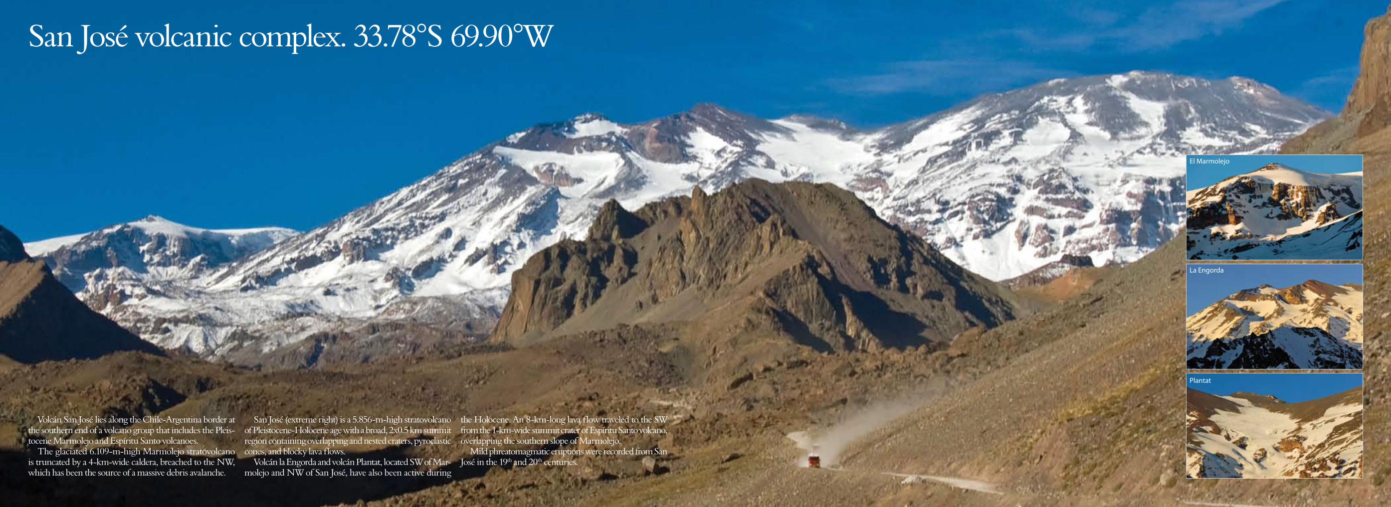
San José volcanic complex. 33.78°S 69.90°W
Volcán San José lies along the Chile-Argentina border at the southern end of a volcano group that includes the Pleis-tocene Marmolejo and Espíritu Santo volcanoes.
The glaciated 6.109-m-high Marmolejo stratovolcano is truncated by a 4-km-wide caldera, breached to the NW, which has been the source of a massive debris avalanche.
San José (extreme right) is a 5.856-m-high stratovolcano of Pleistocene-Holocene age with a broad, 2x0.5 km summit region containing overlapping and nested craters, pyroclastic cones, and blocky lava flows.
Volcán la Engorda and volcán Plantat, located SW of Mar-molejo and NW of San José, have also been active during
the Holocene. An 8-km-long lava flow traveled to the SW from the 1-km-wide summit crater of Espíritu Santo volcano, overlapping the southern slope of Marmolejo.
Mild phreatomagmatic eruptions were recorded from San José in the 19th and 20th centuries.
El Marmolejo
La Engorda
Plantat
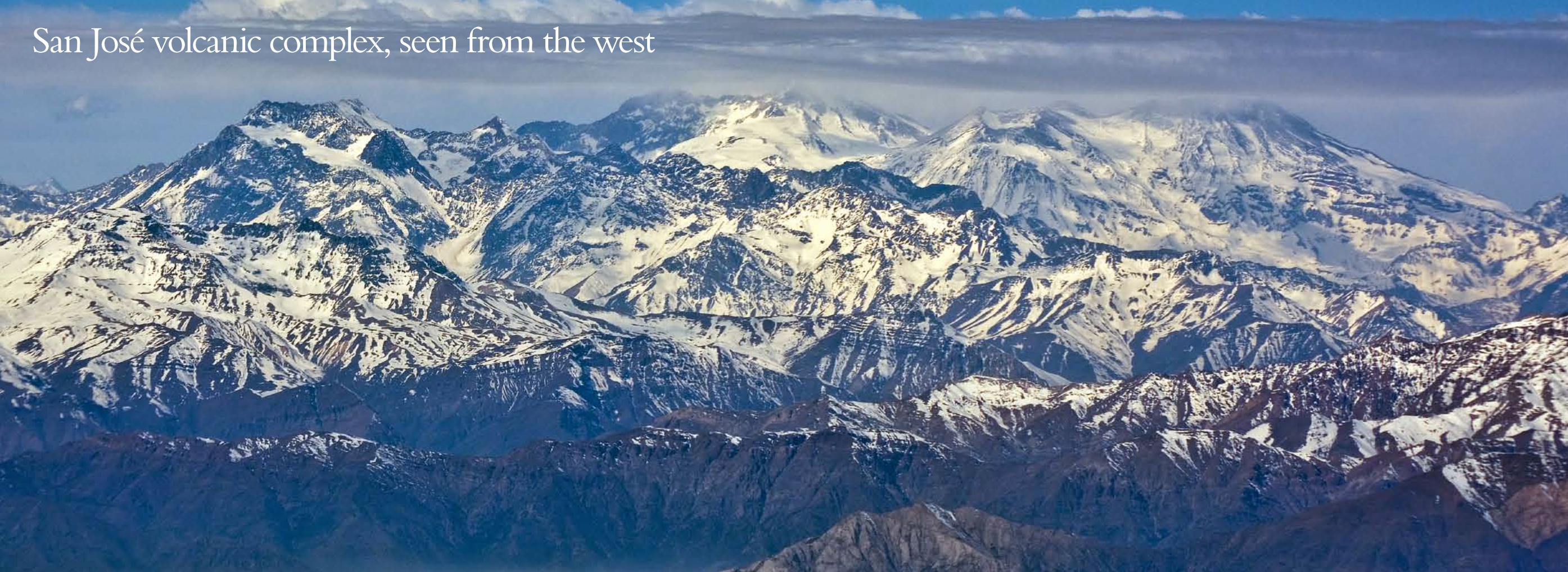
San José volcanic complex, seen from the west
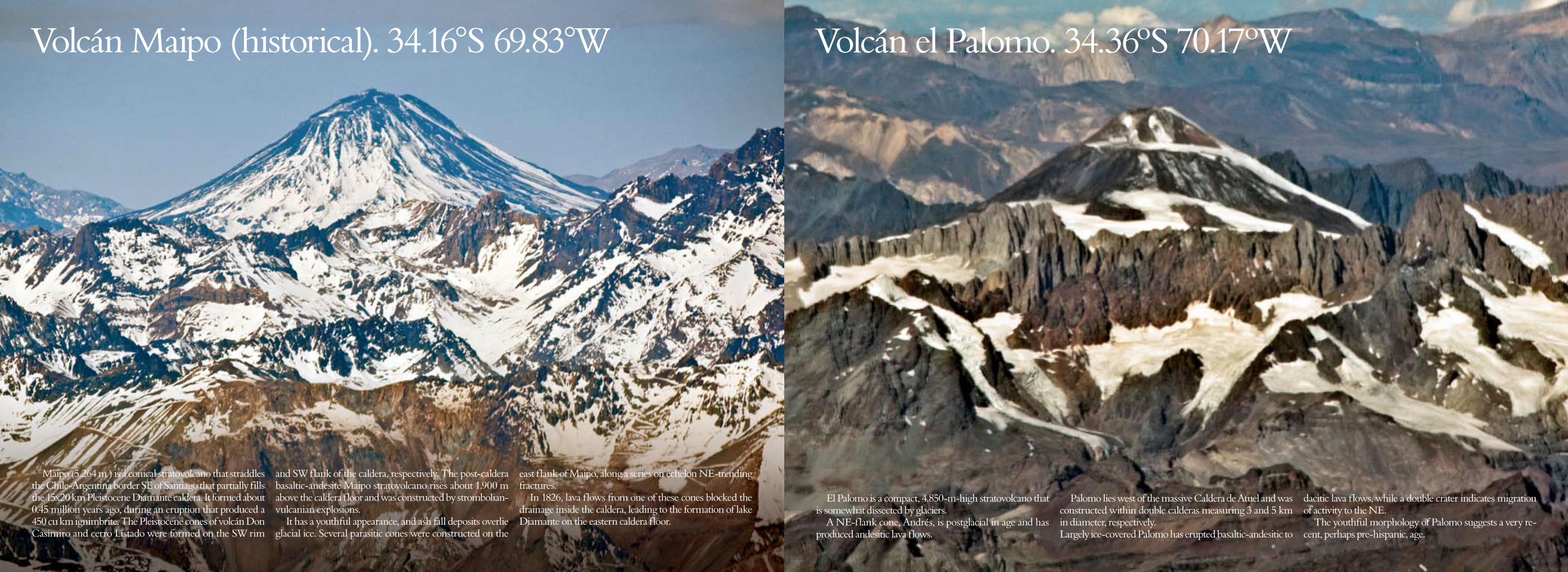
Volcán Maipo (historical). 34.16°S 69.83°W
Maipo (5.264 m ) is a conical stratovolcano that straddles the Chile-Argentina border SE of Santiago that partially fills the 15x20 km Pleistocene Diamante caldera. It formed about 0.45 million years ago, during an eruption that produced a 450 cu km ignimbrite. The Pleistocene cones of volcán Don Casimiro and cerro Listado were formed on the SW rim
and SW flank of the caldera, respectively. The post-caldera basaltic-andesite Maipo stratovolcano rises about 1.900 m above the caldera floor and was constructed by strombolian-vulcanian explosions.
It has a youthful appearance, and ash fall deposits overlie glacial ice. Several parasitic cones were constructed on the
east flank of Maipo, along a series on échelon NE-trending fractures.
In 1826, lava flows from one of these cones blocked the drainage inside the caldera, leading to the formation of lake Diamante on the eastern caldera floor.
Volcán el Palomo. 34.36ºS 70.17ºW
El Palomo is a compact, 4.850-m-high stratovolcano that is somewhat dissected by glaciers.
A NE-flank cone, Andrés, is postglacial in age and has produced andesitic lava flows.
Palomo lies west of the massive Caldera de Atuel and was constructed within double calderas measuring 3 and 5 km in diameter, respectively. Largely ice-covered Palomo has erupted basaltic-andesitic to
dacitic lava flows, while a double crater indicates migration of activity to the NE.
The youthful morphology of Palomo suggests a very re-cent, perhaps pre-hispanic, age.
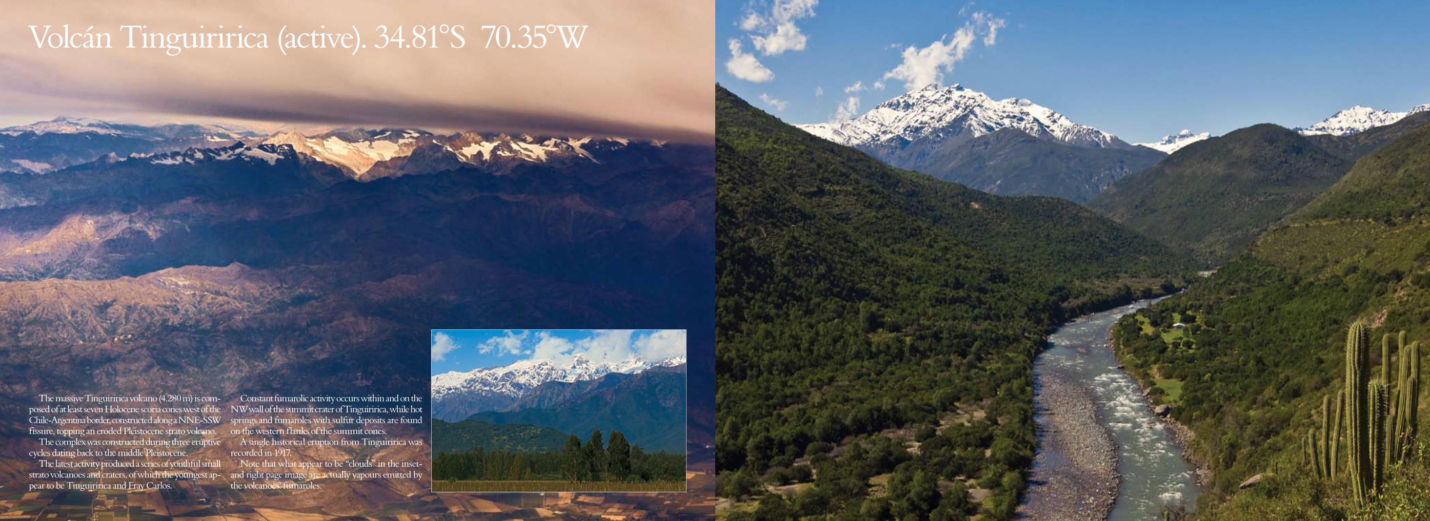
Volcán Tinguiririca (active). 34.81°S 70.35°W
The massive Tinguiririca volcano (4.280 m) is com-posed of at least seven Holocene scoria cones west of the Chile-Argentina border, constructed along a NNE-SSW fissure, topping an eroded Pleistocene strato volcano.
The complex was constructed during three eruptive cycles dating back to the middle Pleistocene.
The latest activity produced a series of youthful small strato volcanoes and craters, of which the youngest ap-pear to be Tinguiririca and Fray Carlos.
Constant fumarolic activity occurs within and on the NW wall of the summit crater of Tinguiririca, while hot springs and fumaroles with sulfur deposits are found on the western flanks of the summit cones.
A single historical eruption from Tinguiririca was recorded in 1917.
Note that what appear to be “clouds” in the inset- and right page image are actually vapours emitted by the volcanoes’ fumaroles.

Peteroa volcanic complex (active). 35.24ºS 70.60ºW
Planchón-Peteroa (3.977 m) is a 4-km-long complex vol-cano along the Chile-Argentina border, that contains several overlapping calderas (inset image, next page).
Activity began in the Pleistocene with construction of the basaltic-andesite to dacitic volcán Azufre, followed by formation of basaltic and basaltic-andesite volcán Planchón (opposite page), 4 km to the north.
About 11.500 years ago, much of Azufre and part of Planchón collapsed, causing the massive Río Teno river de-bris avalanche, which reached Chile’s central valley. Subse-quently, volcán Planchón II was formed.
The youngest volcano, andesitic and basaltic-andesite vol-cán Peteroa, consists of scattered vents between Azufre and Planchón. Peteroa has been active into historical time and
contains a small steaming crater lake, indicated by a dark grey “cloud” at the LH third of the image. Historical eruptions from the Planchón-Peteroa complex have been dominantly explo-sive, although lava flows were erupted in 1837 and 1937.
In September 2010, the group erupted on three different occasions, while the latest – and more prolonged – activity took place between February and June 2011.
Volcán Planchón. 35.27ºS 70.58ºW

The Planchón-Peteroa volcanic complex from the west
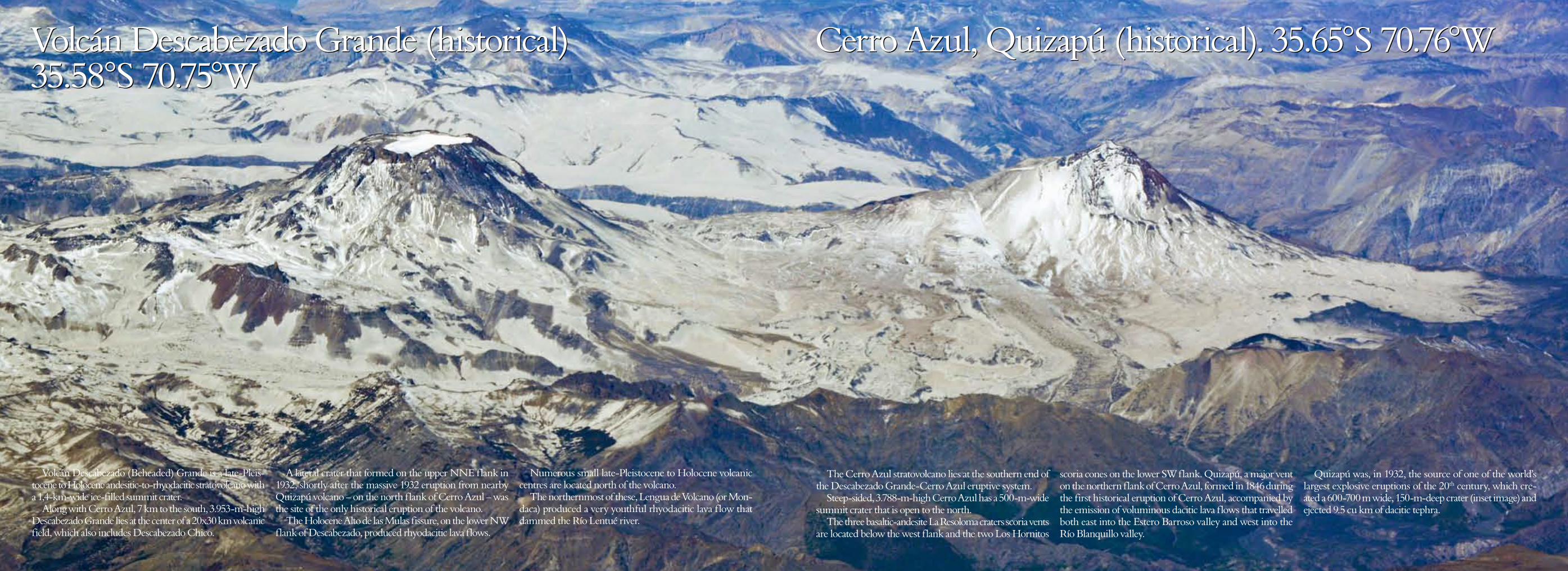
Volcán Descabezado Grande (historical) 35.58°S 70.75°W
Cerro Azul, Quizapú (historical). 35.65°S 70.76°W
The Cerro Azul stratovolcano lies at the southern end of the Descabezado Grande-Cerro Azul eruptive system.
Steep-sided, 3.788-m-high Cerro Azul has a 500-m-wide summit crater that is open to the north.
The three basaltic-andesite La Resoloma craters scoria vents are located below the west flank and the two Los Hornitos
scoria cones on the lower SW flank. Quizapú, a major vent on the northern flank of Cerro Azul, formed in 1846 during the first historical eruption of Cerro Azul, accompanied by the emission of voluminous dacitic lava flows that travelled both east into the Estero Barroso valley and west into the Río Blanquillo valley.
Quizapú was, in 1932, the source of one of the world’s largest explosive eruptions of the 20th century, which cre-ated a 600-700 m wide, 150-m-deep crater (inset image) and ejected 9.5 cu km of dacitic tephra.
Volcán Descabezado (Beheaded) Grande is a late-Pleis-tocene to Holocene andesitic-to-rhyodacitic stratovolcano with a 1,4-km-wide ice-filled summit crater.
Along with Cerro Azul, 7 km to the south, 3.953-m-high Descabezado Grande lies at the center of a 20x30 km volcanic field, which also includes Descabezado Chico.
A lateral crater that formed on the upper NNE flank in 1932, shortly after the massive 1932 eruption from nearby Quizapú volcano – on the north flank of Cerro Azul – was the site of the only historical eruption of the volcano.
The Holocene Alto de las Mulas fissure, on the lower NW flank of Descabezado, produced rhyodacitic lava flows.
Numerous small late-Pleistocene to Holocene volcanic centres are located north of the volcano.
The northernmost of these, Lengua de Volcano (or Mon-daca) produced a very youthful rhyodacitic lava flow that dammed the Río Lentué river.
Volcán Descabezado Grande (historical) 35.58°S 70.75°W
Cerro Azul, Quizapú (historical). 35.65°S 70.76°W
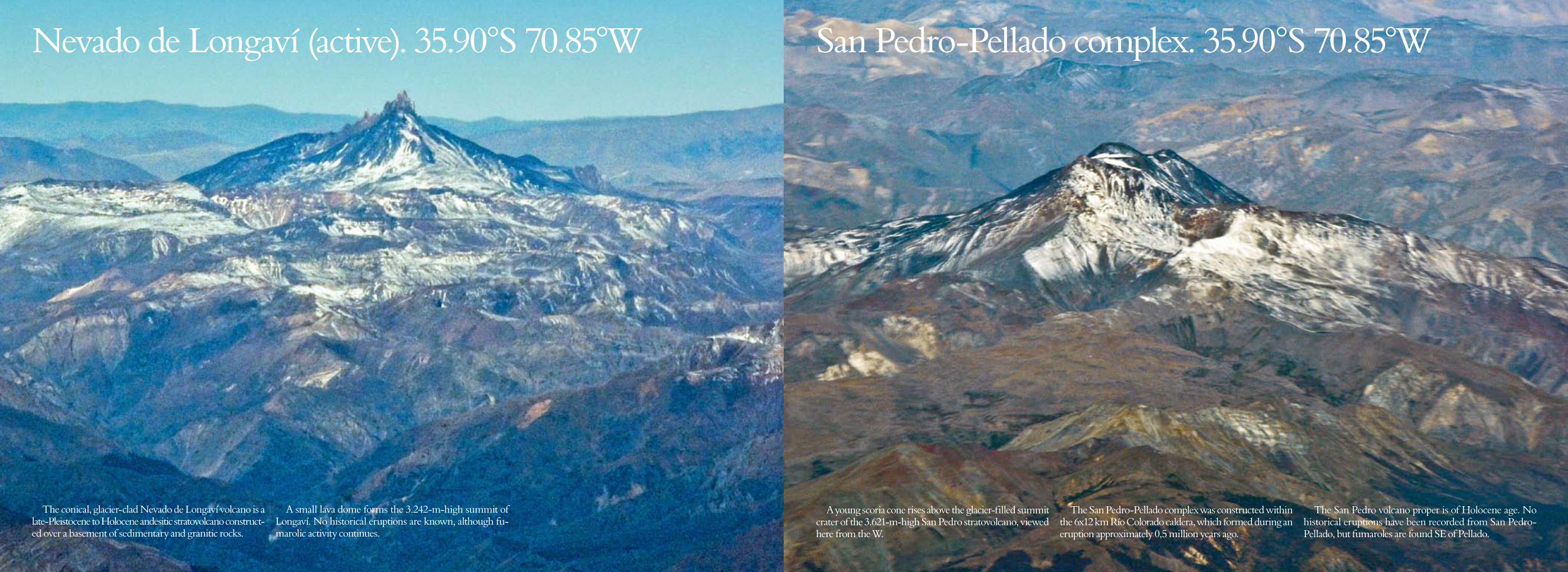
Nevado de Longaví (active). 35.90°S 70.85°W San Pedro-Pellado complex. 35.90°S 70.85°W
A young scoria cone rises above the glacier-filled summit crater of the 3.621-m-high San Pedro stratovolcano, viewed here from the W.
The San Pedro-Pellado complex was constructed within the 6x12 km Río Colorado caldera, which formed during an eruption approximately 0,5 million years ago.
The San Pedro volcano proper is of Holocene age. No historical eruptions have been recorded from San Pedro-Pellado, but fumaroles are found SE of Pellado.
The conical, glacier-clad Nevado de Longaví volcano is a late-Pleistocene to Holocene andesitic stratovolcano construct-ed over a basement of sedimentary and granitic rocks.
A small lava dome forms the 3.242-m-high summit of Longaví. No historical eruptions are known, although fu-marolic activity continues.
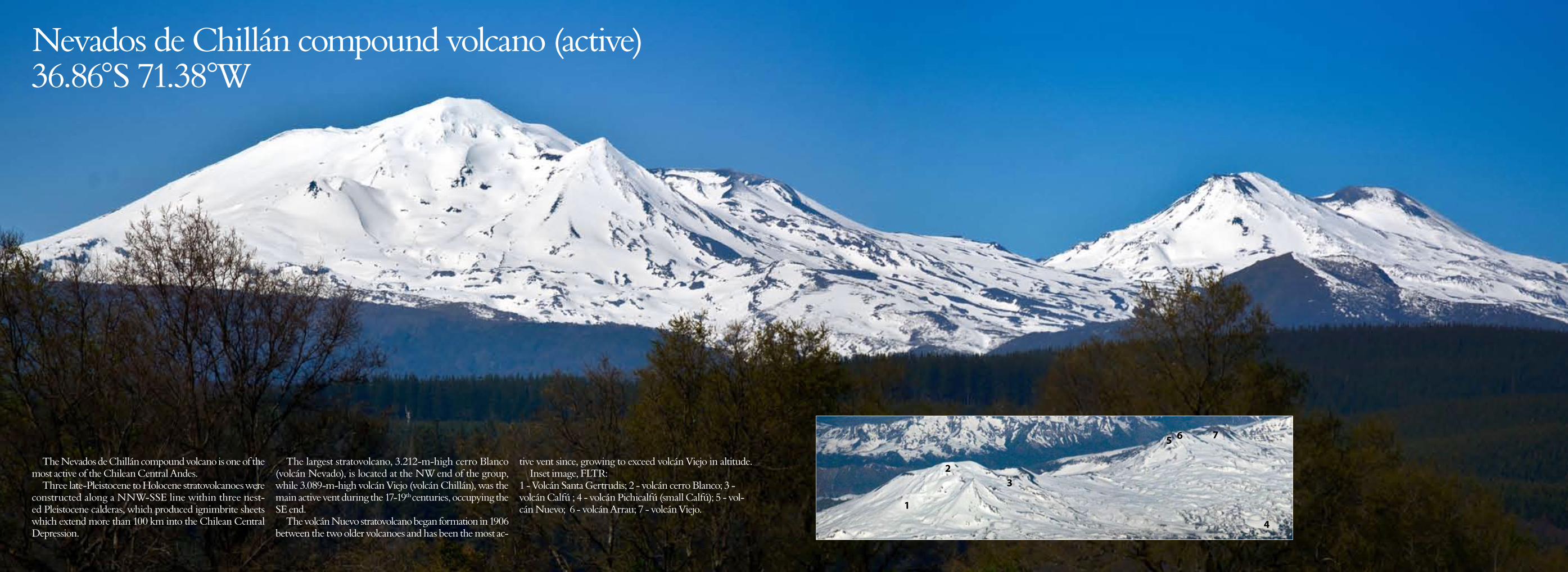
Nevados de Chillán compound volcano (active) 36.86°S 71.38°W
The Nevados de Chillán compound volcano is one of the most active of the Chilean Central Andes.
Three late-Pleistocene to Holocene stratovolcanoes were constructed along a NNW-SSE line within three nest-ed Pleistocene calderas, which produced ignimbrite sheets which extend more than 100 km into the Chilean Central Depression.
The largest stratovolcano, 3.212-m-high cerro Blanco (volcán Nevado), is located at the NW end of the group, while 3.089-m-high volcán Viejo (volcán Chillán), was the main active vent during the 17-19th centuries, occupying the SE end.
The volcán Nuevo stratovolcano began formation in 1906 between the two older volcanoes and has been the most ac-
tive vent since, growing to exceed volcán Viejo in altitude.Inset image, FLTR:
1 - Volcán Santa Gertrudis; 2 - volcán cerro Blanco; 3 - volcán Calfú ; 4 - volcán Pichicalfú (small Calfú); 5 - vol-cán Nuevo; 6 - volcán Arrau; 7 - volcán Viejo.
1
23
4
5 6 7
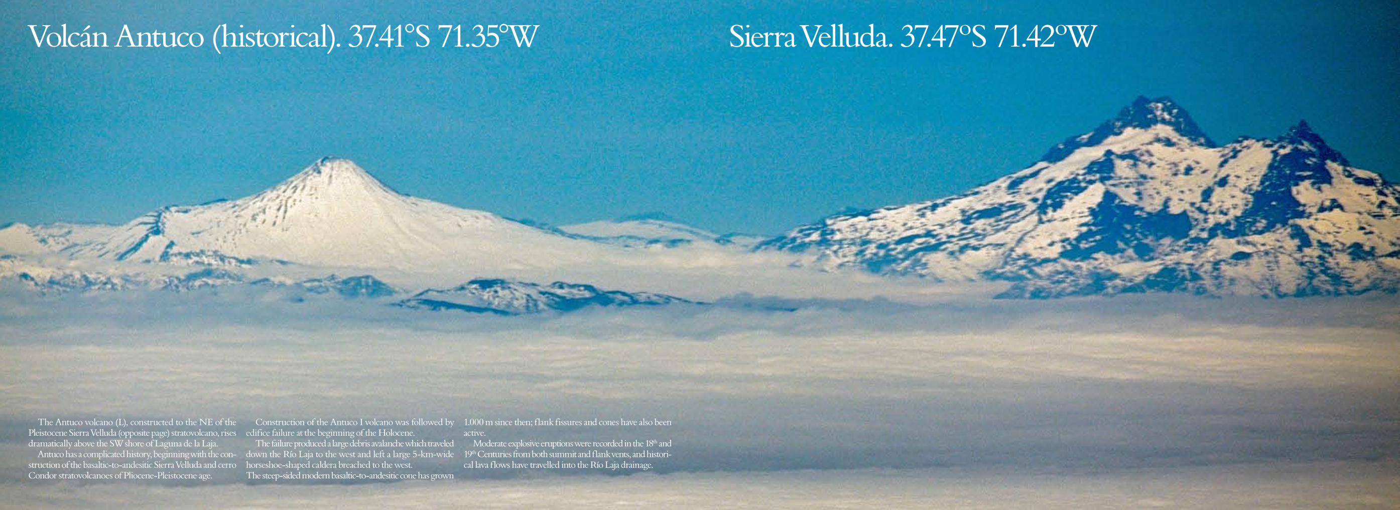
Volcán Antuco (historical). 37.41°S 71.35°W
The Antuco volcano (L), constructed to the NE of the Pleistocene Sierra Velluda (opposite page) stratovolcano, rises dramatically above the SW shore of Laguna de la Laja.
Antuco has a complicated history, beginning with the con-struction of the basaltic-to-andesitic Sierra Velluda and cerro Condor stratovolcanoes of Pliocene-Pleistocene age.
Construction of the Antuco I volcano was followed by edifice failure at the beginning of the Holocene.
The failure produced a large debris avalanche which traveled down the Río Laja to the west and left a large 5-km-wide horseshoe-shaped caldera breached to the west. The steep-sided modern basaltic-to-andesitic cone has grown
1.000 m since then; flank fissures and cones have also been active.
Moderate explosive eruptions were recorded in the 18th and 19th Centuries from both summit and flank vents, and histori-cal lava flows have travelled into the Río Laja drainage.
Sierra Velluda. 37.47ºS 71.42ºW
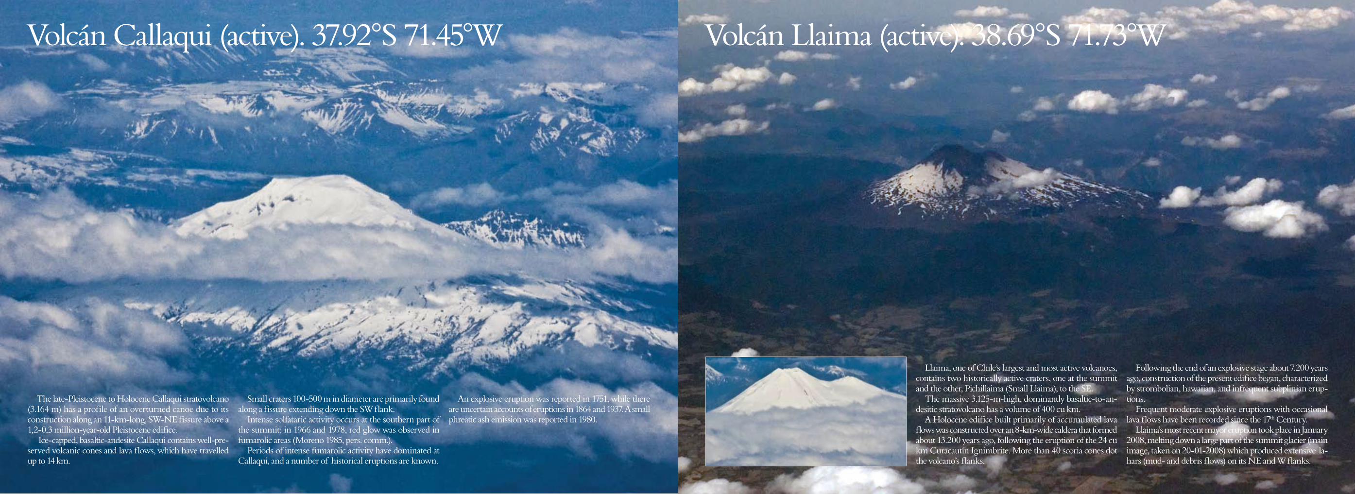
Volcán Callaqui (active). 37.92°S 71.45°W
The late-Pleistocene to Holocene Callaqui stratovolcano (3.164 m) has a profile of an overturned canoe due to its construction along an 11-km-long, SW-NE fissure above a 1,2-0,3 million-year-old Pleistocene edifice.
Ice-capped, basaltic-andesite Callaqui contains well-pre-served volcanic cones and lava flows, which have travelled up to 14 km.
Small craters 100-500 m in diameter are primarily found along a fissure extending down the SW flank.
Intense solfataric activity occurs at the southern part of the summit; in 1966 and 1978, red glow was observed in fumarolic areas (Moreno 1985, pers. comm.).
Periods of intense fumarolic activity have dominated at Callaqui, and a number of historical eruptions are known.
An explosive eruption was reported in 1751, while there are uncertain accounts of eruptions in 1864 and 1937. A small phreatic ash emission was reported in 1980.
Volcán Llaima (active). 38.69°S 71.73°W
Llaima, one of Chile’s largest and most active volcanoes, contains two historically active craters, one at the summit and the other, Pichillaima (Small Llaima), to the SE.
The massive 3.125-m-high, dominantly basaltic-to-an-desitic stratovolcano has a volume of 400 cu km.
A Holocene edifice built primarily of accumulated lava flows was constructed over an 8-km-wide caldera that formed about 13.200 years ago, following the eruption of the 24 cu km Curacautín Ignimbrite. More than 40 scoria cones dot the volcano’s flanks.
Following the end of an explosive stage about 7.200 years ago, construction of the present edifice began, characterized by strombolian, hawaiian, and infrequent subplinian erup-tions.
Frequent moderate explosive eruptions with occasional lava flows have been recorded since the 17th Century.
Llaima’s most recent mayor eruption took place in January 2008, melting down a large part of the summit glacier (main image, taken on 20-01-2008) which produced extensive la-hars (mud- and debris flows) on its NE and W flanks.
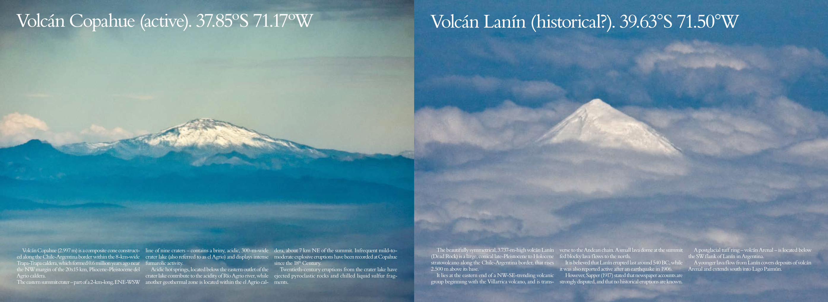
Volcán Lanín (historical?). 39.63°S 71.50°W Volcán Copahue (active). 37.85ºS 71.17ºW
The beautifully symmetrical, 3.737-m-high volcán Lanín (Dead Rock) is a large, conical late-Pleistocene to Holocene stratovolcano along the Chile-Argentina border, that rises 2.500 m above its base.
It lies at the eastern end of a NW-SE-trending volcanic group beginning with the Villarrica volcano, and is trans-
verse to the Andean chain. A small lava dome at the summit fed blocky lava flows to the north.
It is believed that Lanín erupted last around 540 BC, while it was also reported active after an earthquake in 1906.
However, Sapper (1917) stated that newspaper accounts are strongly disputed, and that no historical eruptions are known.
A postglacial tuff ring – volcán Arenal – is located below the SW flank of Lanín in Argentina.
A younger lava flow from Lanín covers deposits of volcán Arenal and extends south into Lago Paimún.
Volcán Copahue (2.997 m) is a composite cone construct-ed along the Chile-Argentina border within the 8-km-wide Trapa-Trapa caldera, which formed 0.6 million years ago near the NW margin of the 20x15 km, Pliocene-Pleistocene del Agrio caldera. The eastern summit crater – part of a 2-km-long, ENE-WSW
line of nine craters – contains a briny, acidic, 300-m-wide crater lake (also referred to as el Agrio) and displays intense fumarolic activity.
Acidic hot springs, located below the eastern outlet of the crater lake contribute to the acidity of Río Agrio river, while another geothermal zone is located within the el Agrio cal-
dera, about 7 km NE of the summit. Infrequent mild-to-moderate explosive eruptions have been recorded at Copahue since the 18th Century.
Twentieth-century eruptions from the crater lake have ejected pyroclastic rocks and chilled liquid sulfur frag-ments.
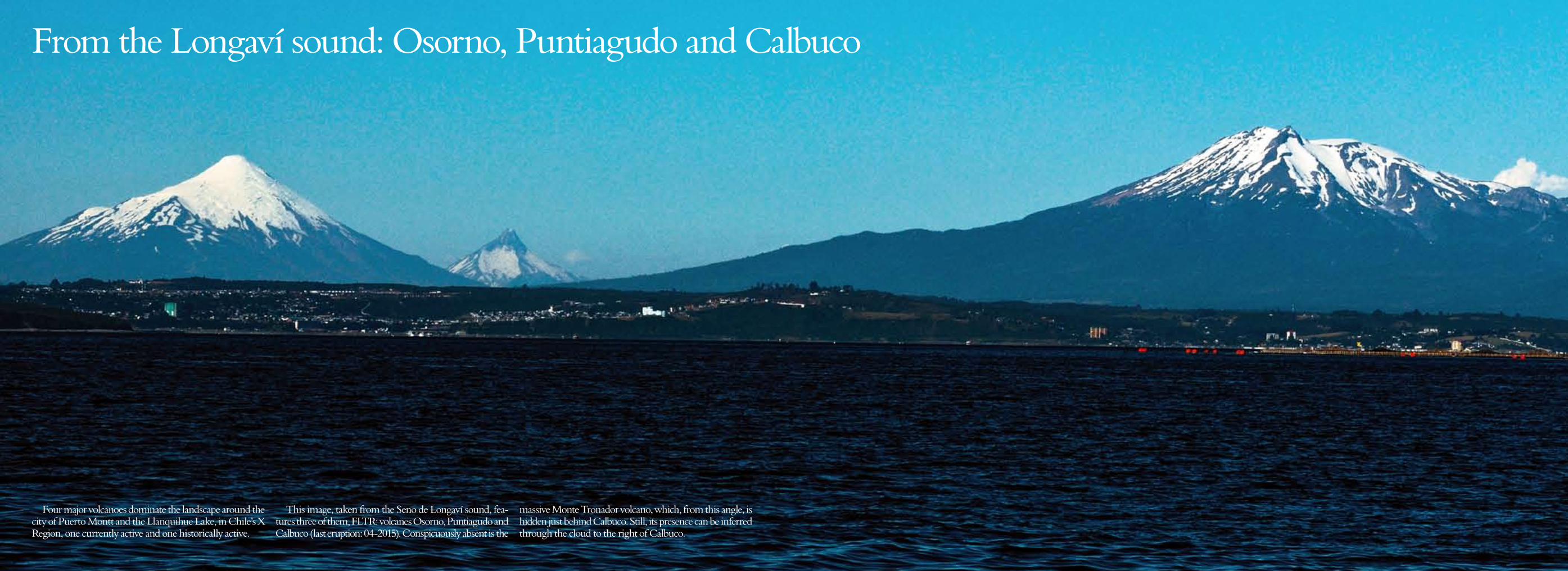
From the Longaví sound: Osorno, Puntiagudo and Calbuco
Four major volcanoes dominate the landscape around the city of Puerto Montt and the Llanquihue Lake, in Chile’s X Region, one currently active and one historically active.
This image, taken from the Seno de Longaví sound, fea-tures three of them, FLTR: volcanes Osorno, Puntiagudo and Calbuco (last eruption: 04-2015). Conspicuously absent is the
massive Monte Tronador volcano, which, from this angle, is hidden just behind Calbuco. Still, its presence can be inferred through the cloud to the right of Calbuco.
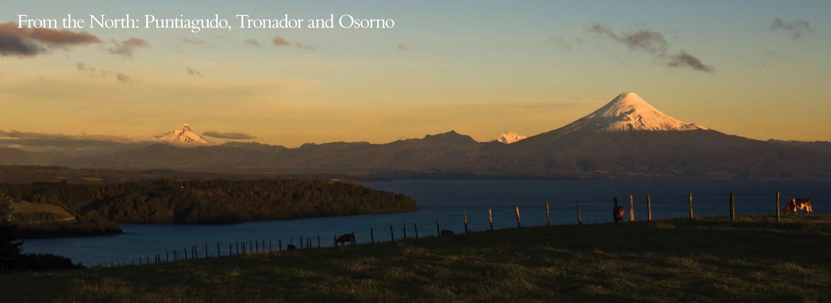
From the North: Puntiagudo, Tronador and Osorno
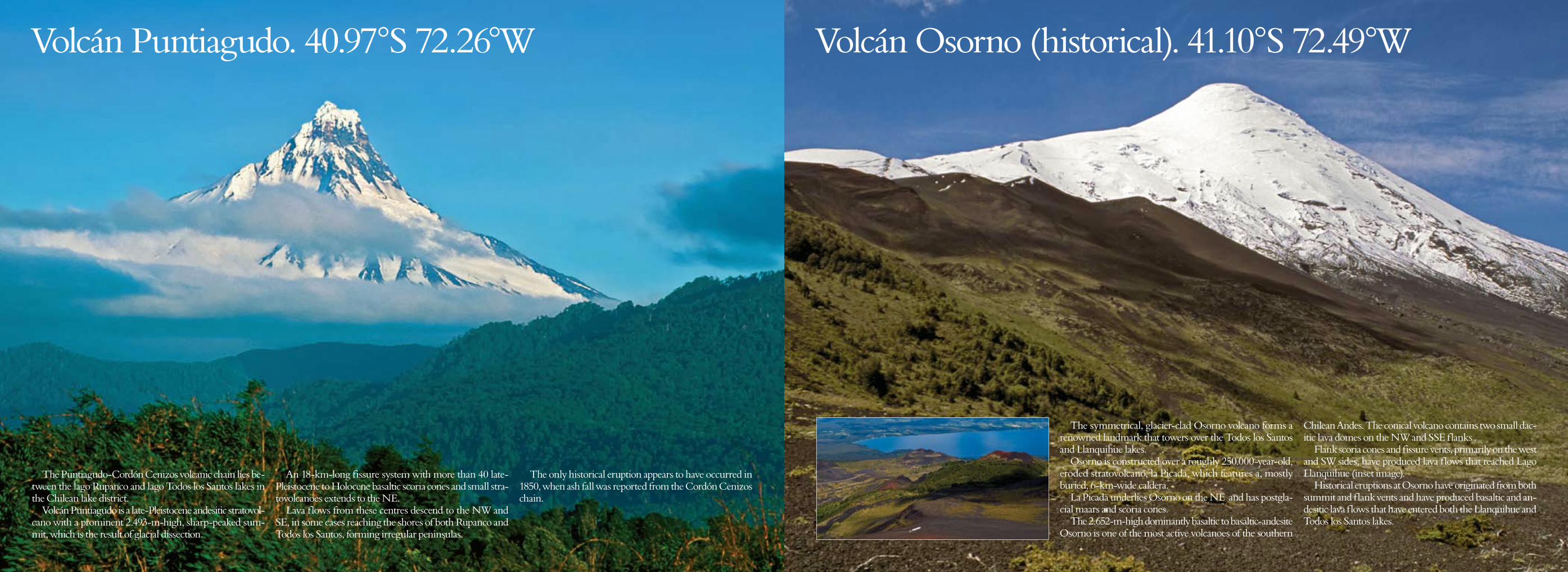
Volcán Puntiagudo. 40.97°S 72.26°W
The Puntiagudo-Cordón Cenizos volcanic chain lies be-tween the lago Rupanco and lago Todos los Santos lakes in the Chilean lake district.
Volcán Puntiagudo is a late-Pleistocene andesitic stratovol-cano with a prominent 2.493-m-high, sharp-peaked sum-mit, which is the result of glacial dissection.
An 18-km-long fissure system with more than 40 late-Pleistocene to Holocene basaltic scoria cones and small stra-tovolcanoes extends to the NE.
Lava flows from these centres descend to the NW and SE, in some cases reaching the shores of both Rupanco and Todos los Santos, forming irregular peninsulas.
The only historical eruption appears to have occurred in 1850, when ash fall was reported from the Cordón Cenizos chain.
Volcán Osorno (historical). 41.10°S 72.49°W
The symmetrical, glacier-clad Osorno volcano forms a renowned landmark that towers over the Todos los Santos and Llanquihue lakes.
Osorno is constructed over a roughly 250.000-year-old, eroded stratovolcano, la Picada, which features a, mostly buried, 6-km-wide caldera.
La Picada underlies Osorno on the NE and has postgla-cial maars and scoria cones.
The 2.652-m-high dominantly basaltic to basaltic-andesite Osorno is one of the most active volcanoes of the southern
Chilean Andes. The conical volcano contains two small dac-itic lava domes on the NW and SSE flanks .
Flank scoria cones and fissure vents, primarily on the west and SW sides, have produced lava flows that reached Lago Llanquihue (inset image).
Historical eruptions at Osorno have originated from both summit and flank vents and have produced basaltic and an-desitic lava flows that have entered both the Llanquihue and Todos los Santos lakes.
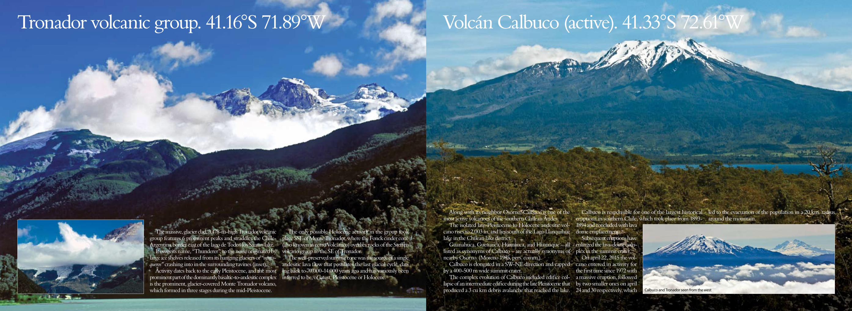
Volcán Calbuco (active). 41.33°S 72.61°W
Along with its neighbor Osorno, Calbuco is one of the most active volcanoes of the southern Chilean Andes.
The isolated late-Pleistocene to Holocene andesitic vol-cano rises to 2.003 m, and lies south of the Lago Llanquihue lake in the Chilean lake district.
Guanahuca, Guenauca, Huanauca, and Huanaque – all listed as synonyms of Calbuco – are actually synonyms of nearby Osorno. (Moreno 1985, pers. comm.).
Calbuco is elongated in a SW-NE direction and capped by a 400-500 m wide summit crater.
The complex evolution of Calbuco included edifice col-lapse of an intermediate edifice during the late Pleistocene that produced a 3 cu km debris avalanche that reached the lake.
Calbuco is responsible for one of the largest historical eruptions in southern Chile, which took place from 1893-1894 and concluded with lava dome emplacement.
Subsequent eruptions have enlarged the lava-dome com-plex in the summit crater.
On april 22, 2015 the vol-cano entered in activity for the first time since 1972 with a massive eruption, followed by two smaller ones on april 24 and 30 respectively, which
led to the evacuation of the population in a 20 km. radius around the mountain.
Tronador volcanic group. 41.16°S 71.89°W
The massive, glacier clad, 3.478-m-high Tronador volcanic group features 6 prominent peaks and straddles the Chile-Argentina border east of the lago de Todos los Santos lake.
It owes its name, “Thunderer”, to the noise originated by large ice shelves released from its hanging glaciers or “ventis-queros” crashing into in the surrounding ravines (inset).
Activity dates back to the early Pleistocene, and the most prominent part of the dominantly basaltic-to-andesitic complex is the prominent, glacier-covered Monte Tronador volcano, which formed in three stages during the mid-Pleistocene.
The only possible Holocene activity in the group took place SSE of Monte Tronador, where the Fonck cinder cone (also known as cerro Volcánico) overlies rocks of the Steffen volcano group to the SE of Tronador.
The well-preserved summit cone was the source of a single andesitic lava flow that postdates the last glacial cycle, dat-ing back to 70.000-14.000 years ago and has variously been inferred to be, of latest, Pleistocene or Holocene.
Calbuco and Tronador seen from the west
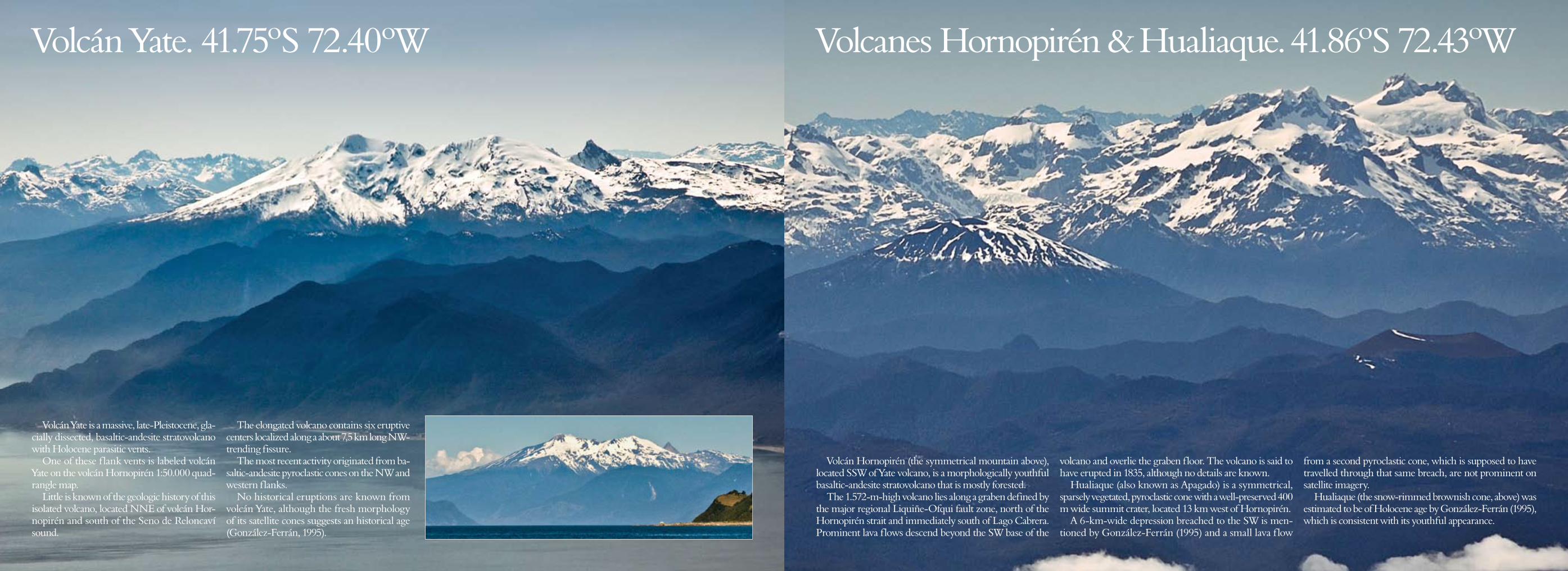
Volcán Yate. 41.75ºS 72.40ºW
Volcán Yate is a massive, late-Pleistocene, gla-cially dissected, basaltic-andesite stratovolcano with Holocene parasitic vents.
One of these flank vents is labeled volcán Yate on the volcán Hornopirén 1:50.000 quad-rangle map.
Little is known of the geologic history of this isolated volcano, located NNE of volcán Hor-nopirén and south of the Seno de Reloncaví sound.
The elongated volcano contains six eruptive centers localized along a about 7,5 km long NW-trending fissure.
The most recent activity originated from ba-saltic-andesite pyroclastic cones on the NW and western flanks.
No historical eruptions are known from volcán Yate, although the fresh morphology of its satellite cones suggests an historical age (González-Ferrán, 1995).
Volcanes Hornopirén & Hualiaque. 41.86ºS 72.43ºW
Volcán Hornopirén (the symmetrical mountain above), located SSW of Yate volcano, is a morphologically youthful basaltic-andesite stratovolcano that is mostly forested.
The 1.572-m-high volcano lies along a graben defined by the major regional Liquiñe-Ofqui fault zone, north of the Hornopirén strait and immediately south of Lago Cabrera. Prominent lava flows descend beyond the SW base of the
volcano and overlie the graben floor. The volcano is said to have erupted in 1835, although no details are known.
Hualiaque (also known as Apagado) is a symmetrical, sparsely vegetated, pyroclastic cone with a well-preserved 400 m wide summit crater, located 13 km west of Hornopirén.
A 6-km-wide depression breached to the SW is men-tioned by González-Ferrán (1995) and a small lava flow
from a second pyroclastic cone, which is supposed to have travelled through that same breach, are not prominent on satellite imagery.
Hualiaque (the snow-rimmed brownish cone, above) was estimated to be of Holocene age by González-Ferrán (1995), which is consistent with its youthful appearance.
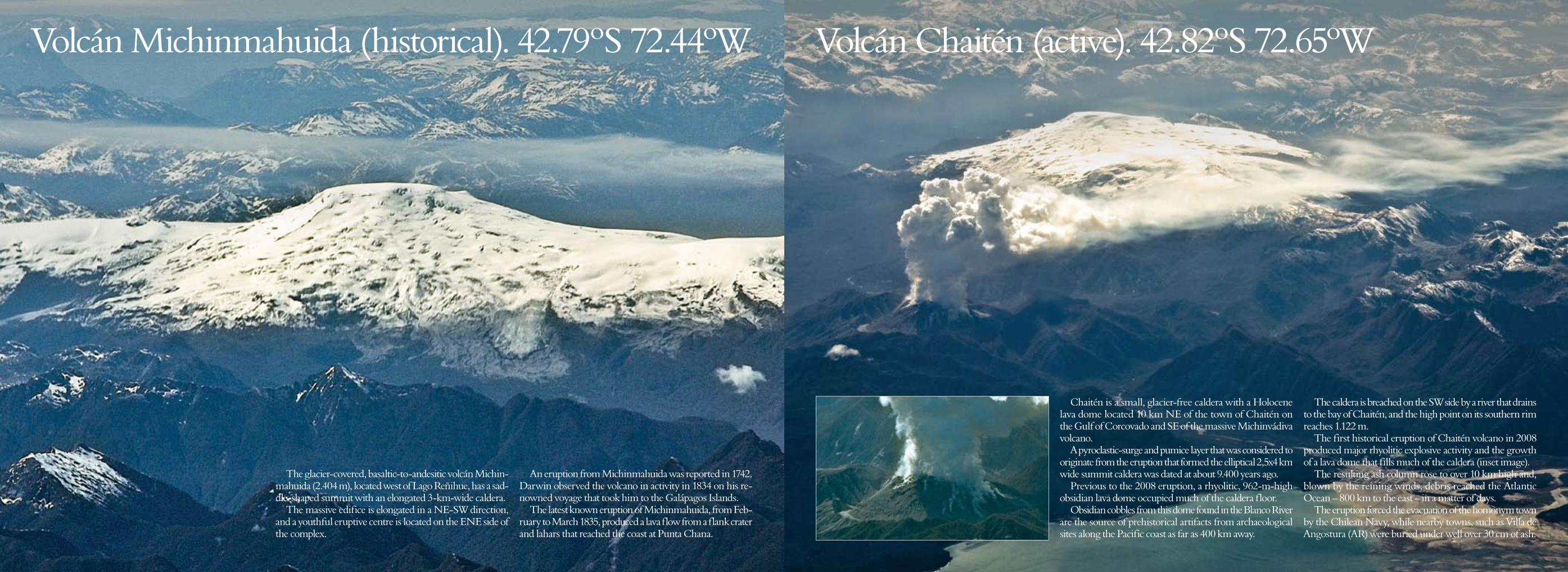
Volcán Michinmahuida (historical). 42.79ºS 72.44ºW
The glacier-covered, basaltic-to-andesitic volcán Michin-mahuida (2.404 m), located west of Lago Reñihue, has a sad-dle-shaped summit with an elongated 3-km-wide caldera.
The massive edifice is elongated in a NE-SW direction, and a youthful eruptive centre is located on the ENE side of the complex.
An eruption from Michinmahuida was reported in 1742. Darwin observed the volcano in activity in 1834 on his re-nowned voyage that took him to the Galápagos Islands.
The latest known eruption of Michinmahuida, from Feb-ruary to March 1835, produced a lava flow from a flank crater and lahars that reached the coast at Punta Chana.
Volcán Chaitén (active). 42.82ºS 72.65ºW
Chaitén is a small, glacier-free caldera with a Holocene lava dome located 10 km NE of the town of Chaitén on the Gulf of Corcovado and SE of the massive Michinvádiva volcano.
A pyroclastic-surge and pumice layer that was considered to originate from the eruption that formed the elliptical 2,5x4 km wide summit caldera was dated at about 9.400 years ago.
Previous to the 2008 eruption, a rhyolitic, 962-m-high obsidian lava dome occupied much of the caldera floor.
Obsidian cobbles from this dome found in the Blanco River are the source of prehistorical artifacts from archaeological sites along the Pacific coast as far as 400 km away.
The caldera is breached on the SW side by a river that drains to the bay of Chaitén, and the high point on its southern rim reaches 1.122 m.
The first historical eruption of Chaitén volcano in 2008 produced major rhyolitic explosive activity and the growth of a lava dome that fills much of the caldera (inset image).
The resulting ash column rose to over 10 km high and, blown by the reining winds, debris reached the Atlantic Ocean – 800 km to the east – in a matter of days.
The eruption forced the evacuation of the homonym town by the Chilean Navy, while nearby towns, such as Villa de Angostura (AR) were buried under well over 30 cm of ash.
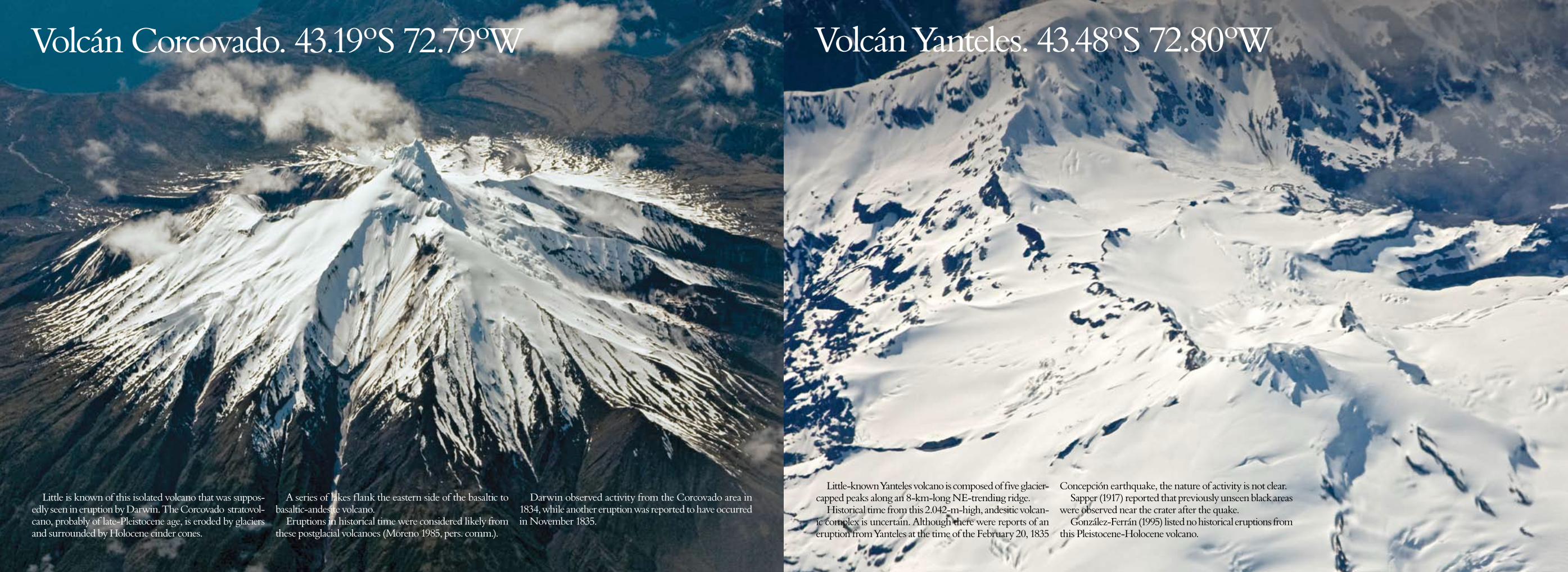
Volcán Corcovado. 43.19ºS 72.79ºW
Little is known of this isolated volcano that was suppos-edly seen in eruption by Darwin. The Corcovado stratovol-cano, probably of late-Pleistocene age, is eroded by glaciers and surrounded by Holocene cinder cones.
A series of lakes flank the eastern side of the basaltic to basaltic-andesite volcano.
Eruptions in historical time were considered likely from these postglacial volcanoes (Moreno 1985, pers. comm.).
Darwin observed activity from the Corcovado area in 1834, while another eruption was reported to have occurred in November 1835.
Little-known Yanteles volcano is composed of five glacier-capped peaks along an 8-km-long NE-trending ridge.
Historical time from this 2.042-m-high, andesitic volcan-ic complex is uncertain. Although there were reports of an eruption from Yanteles at the time of the February 20, 1835
Concepción earthquake, the nature of activity is not clear. Sapper (1917) reported that previously unseen black areas
were observed near the crater after the quake. González-Ferrán (1995) listed no historical eruptions from
this Pleistocene-Holocene volcano.
Volcán Yanteles. 43.48ºS 72.80ºW

To view this presentation in high resolution, go here: http://gerardprins.com/PDF/70-chilean-volcanoes-geo-referenced.pdf
My Flickr Volcanism Album: https://www.flickr.com/photos/gerardprins/sets/72157621756196405
Original texts: Smithsonian Institution Global Volcanism Program,
edited and updated by the author http://www.volcano.si.edu