experience your notes WINTON
4
Route of the River Gum Bladensburg National Park River Gum route Half day drive Front Cover: River Red Gums at Bough Shed Hole Take time to experience Winton and Matilda Country; a rich combination of outback life, landscape and legend. Stay a couple of days and enjoy our country hospitality. Why not take a tour? Or follow one of our self-guided day trips? Discover the intriguing story behind the song ‘Waltzing Matilda’, experience the diverse landscape and bird life at the Bladensburg National Park and the rich Aboriginal rock art at Carisbrooke Station. Try opal hunting, or re-live the age of dinosaurs at the Australian Age of Dinosaurs and Lark Quarry Dinosaur Trackways and Conservation Park. Things to see and do on the “Route of the River Gum” Bring your binoculars for a spot of bird watching at scenic Bladensburg National Park, renowned for its diverse birdlife. Bough Shed Hole is a great spot to have a picnic lunch and enjoy a refreshing swim. Bring your tent along if you want to stay the night and gaze at the spectacular outback night sky, or be on the lookout for the Park’s many animals at dusk. General Information The Route of the River Gum is a loop drive of approximately 51.4km and we suggest you allow three hours – more if you want to explore, swim or picnic. Confirm road conditions at the Winton Visitor Information Centre in Elderslie Street. The drive is open to conventional vehicles in dry weather but the route is impassable and closed when wet. Entry to the National Park is free, but there is no food or water available. Camping is permitted at Bough Shed Hole, where bush toilets are provided. Permits are required from the National Park Information Centre, or self register at the campsite turn off, fees apply. There are very few tracks in the park and bush walks should only be attempted if carefully planned. If you wish to do a bush walk or visit other areas of the Park contact the Ranger for details. Normal National Park restrictions apply. Important Safety Information When driving take regular rest breaks. Keep left at all times. Avoid alcohol. Wear seatbelts. Drive at a safe legal speed. Take care on dirt roads. Watch for animals, particularly at dusk. Avoid driving at sunrise and sunset. Bring at least 7 litres of water per person per day for drinking and cooking. Ensure your car has fuel, a spare tyre, fan belt etc. In an emergency, or if your vehicle breaks down, stay with your vehicle. A vehicle is much easier to find than a person! Key contact details Winton Visitor Information Centre: Toll free: 1300 665 115 Facsimile: (07) 4657 1886 Email: [email protected] Website: www.matildacentre.com.au Queensland Parks and Wildlife Services: www.derm.qld.gov.au Longreach District office: Phone (07) 4650 1990 The Ranger Bladensburg National Park: Phone (07) 4657 1192 Depending on distances you may be able to contact the Ranger on Channel 1 Duplicate. Information sources: Bladensburg National Park, Visitor Information leaflet. QPW your notes WINTON experience WINTON experience
Transcript of experience your notes WINTON
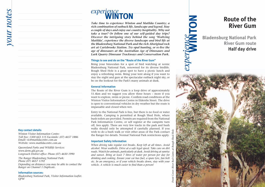
Route of the River Gum
Bladensburg National Park River Gum route
Half day drive
Fron
t C
over
: Riv
er R
ed G
ums
at B
ough
She
d H
ole
Take time to experience Winton and Matilda Country; a rich combination of outback life, landscape and legend. Stay a couple of days and enjoy our country hospitality. Why not take a tour? Or follow one of our self-guided day trips? Discover the intriguing story behind the song ‘Waltzing Matilda’, experience the diverse landscape and bird life at the Bladensburg National Park and the rich Aboriginal rock art at Carisbrooke Station. Try opal hunting, or re-live the age of dinosaurs at the Australian Age of Dinosaurs and Lark Quarry Dinosaur Trackways and Conservation Park.
Things to see and do on the “Route of the River Gum”Bring your binoculars for a spot of bird watching at scenic Bladensburg National Park, renowned for its diverse birdlife. Bough Shed Hole is a great spot to have a picnic lunch and enjoy a refreshing swim. Bring your tent along if you want to stay the night and gaze at the spectacular outback night sky, or be on the lookout for the Park’s many animals at dusk.
General InformationThe Route of the River Gum is a loop drive of approximately 51.4km and we suggest you allow three hours – more if you want to explore, swim or picnic. Confirm road conditions at the Winton Visitor Information Centre in Elderslie Street. The drive is open to conventional vehicles in dry weather but the route is impassable and closed when wet.
Entry to the National Park is free, but there is no food or water available. Camping is permitted at Bough Shed Hole, where bush toilets are provided. Permits are required from the National Park Information Centre, or self register at the campsite turn off, fees apply. There are very few tracks in the park and bush walks should only be attempted if carefully planned. If you wish to do a bush walk or visit other areas of the Park contact the Ranger for details. Normal National Park restrictions apply.
Important Safety InformationWhen driving take regular rest breaks. Keep left at all times. Avoid alcohol. Wear seatbelts. Drive at a safe legal speed. Take care on dirt roads. Watch for animals, particularly at dusk. Avoid driving at sunrise and sunset. Bring at least 7 litres of water per person per day for drinking and cooking. Ensure your car has fuel, a spare tyre, fan belt etc. In an emergency, or if your vehicle breaks down, stay with your vehicle. A vehicle is much easier to find than a person!
Key contact detailsWinton Visitor Information Centre:Toll free: 1300 665 115 Facsimile: (07) 4657 1886 Email: [email protected] Website: www.matildacentre.com.au
Queensland Parks and Wildlife Services: www.derm.qld.gov.au Longreach District office: Phone (07) 4650 1990
The Ranger Bladensburg National Park: Phone (07) 4657 1192 Depending on distances you may be able to contact the Ranger on Channel 1 Duplicate.
Information sources:Bladensburg National Park, Visitor Information leaflet. QPW
your
not
es WINTONexperience
WIN
TON
expe
rien
ce

CarisbrookeStation
Old Cork
Middleton
Opalton
Diamantina National Park
BladensburgNational Park
ComboWaterhole
Windermere Station
Legend Sealed Road
Gravelled Road
Dirt Track
Rivers
National Park
All Facilities
Fuel
Accommodation
Food
Camp Sites
Rest Area
Fossicking
WINTONWestern River
NBladensburgNational Park
20.1
23.6
23.9
24.1
6.7
9.0
9.7
12.4
13.9
3.3
1.5
5.5
Landsborough Highway
Win
ton
JundahRoad
Landsborough Highway
Ranger Station
1.9
11.6
17.220.0
37.1
Long Waterhole
Skull Hole
Engine Hole
Bough ShedHole
24.8
Opalton
25.4
Mistake C
reek
Surp
rise C
reek
0 1 2 2.5 5
Kilometres
WindermereStation
WINTONAustralian Age of Dinosaurs Museum
All of the walks and drives are clockwise
return loops starting from the Winton Visitor
Information Centre. Points of interest are
listed as kilometres, so set your trip meter to zero as you arrive at the town grid on the
Winton/Jundah Road.
Lark QuarryConservation Park
Drive Routes Route of the
River Gums
The Dinosaur Drive
Try Your Luck
Pioneer’s Trail

Route of the River Gum and Bladensburg National ParkFrom the shade of Surprise Creek; river red gums and coolibahs, you can view the vast plains of Mitchell and Flinders grass. Flat topped mesas, plateaus and residual sandstone ranges provide a scenic backdrop to Bladensburg Nation Park. Formerly a grazing property, Bladensburg was designated as a National Park in 1994. The park conserves 85,000 ha of Mitchell grass and channel country, a number of scenic waterholes and culturally significant sites. The park is home to a wonderful diversity of birds, including Emu, Brolga, Australian Bustard, Hall’s Babbler, Spotted Bowerbird and Singing Bushlark. Look for Red Kangaroos on the open Mitchell grasslands, Eastern Grey Kangaroos in the lower creeks and Wallaroos in the mesa areas.
key
attr
acti
ons
PO
INTS
OF
INTE
RES
T 0.0km Visitor Information Centre
Set your trip odometer to zero at the town grid on the Winton-Jundah Road. Enjoy your experience.
1.5km / 49.5km 22.4027 South 143.0393 East Western River
The braided intermittent creeks you are crossing are part of the Western River and are typical of channel country in Outback Queensland. The catchment for Winton and the Western River, forms part of the Great Artesian Basin and drains 1500km towards Lake Eyre North. The attractive grey-green leafed tree is Eucalyptus Microtheca or ‘Coolibah’. It is one of these that the swaggie camped under in the song Waltzing Matilda. Can you remember the lines “…under the shade of a “coolibah” tree…”? Other plants that inhabit these creeks are Black Wattle and Prickly Acacia. When the town was gazetted in the “Government Gazzette” on the 5th of July, 1879, the Western River formed part of its boundary. During floods, the river becomes many times wider and floods the lower sections of town.
1.9km / 49.5km 22.4027 South 143.0393 East Long Waterhole, bike track and rodeo yards turn off
(4.5 km round trip)
Long Waterhole is man-made and was once used during the Outback Festival as the site for the biennial World Crayfish Derby. It is a popular camping and picnic spot and is great for bird watching and fishing. A bike track designed for motorbikes runs around the waterhole.
The rodeo yards were built in 1978 by keen rodeo enthusiasts who ride the bulls, steers and horses for fun! World champion buck-jumping rider, Ray Hermann, often practised in these yards.
3.3km / 48.1km 22.4169 South 143.0338 East Mistake Creek
Mistake Creek is the scene of the murder of a young boy in the 1800s. By 1895 this area supported nine Chinese market gardens producing a complete range of fresh fruit and vegetables for the township. The Cragg Family Bridge at Mistake Creek is named to honour this pioneering family who lived here until the 1950s. It is a good picnic and fishing area, Yellowbelly are often caught in the creek.
5.5km / 45.9km 22.4335 South 143.0257 East Western Picnic Race Club
The first Picnic Race Club in the area was the Never Never Jockey Club. It is believed that this is the first time the term ‘never never’
was used in Outback Australia. A silver trophy, The Corinthian Cup, won in 1879 is displayed at the Waltzing Matilda Centre, and the race was again contested at the Waltzing Matilda Centenary celebrations in 1995. Picnic Races are amateur horse races and the horse must only be grass fed. The first race meeting was held on April 27 and 28, 1922.
6.7km / 44.7km 22.4367 South 142.0318 East Bladensburg National Park turn off
Turn left and follow signs to Bladensburg National Park. The road initially passes through the town common where stock graze at the owner’s risk.
9.0km / 42.4km 22.4548 South 143.0032 East Red Creek
Just after Red Creek, note the Gidyea trees, a species of Acacia. This very hard wood is used extensively for rural fence posts and is excellent fuel for camp fires. The Aborigines used Gidyea to make boomerangs, a faulty boomerang still contained in a tree trunk may be seen in the Qantilda Museum. Apostle birds (also known as Lousy Jacks because of lice) frequent this creek area.
9.7km / 41.7km 22.4604 South 143.0020 East 1894 Shearers’ Strike Memorial
Turn left to the memorial built by the Winton branch of the ALP and the Winton and District Historical Society in 1975. It was here that 500 shearers camped during the strike of 1891 and 1894, when Winton was under martial law. This was the beginning of the foundation of the Australian Labour Party. More Gidyea trees surround this area.
11.6km / 39.8km 22.4779 South 143.0030 East Bladensburg National Park Headquarters turn-off
The left hand road leads to the National Park Information Centre and original homestead buildings. Keep to the right hand road to continue on the Route of the River Gum.
12.4km / 39.0km 22.4845 South 143.0027 East Bladensburg National Park entry grid
Typical tree species in this area are Bloodwood, Bauhinia (with butterfly shaped leaves) and Mimosa (a prickly shrub weed). Bladensburg was first taken up in 1874 by Henry Cory, and registered on March 18, 1875 in the name of Euston Blomfield. In 1891, J.A. McCartney owned the property and ran 10, 000 head of cattle. The Park was purchases in 1993 by Queensland Parks and Wildlife and is yet to be fully developed.
1894 Shearers’ Strike Memorial

13.9km / 37.5km 22.4982 South 143.0053 East Claypans
The claypans are flat areas along the creek. The surface is white, smooth and hard, and no vegetation grows except in the wet season. Because of the claypans, rain runs into waterholes as freely as if it were running off an iron roof. Half an inch of rain quickly fills nearby waterholes. In early days, drovers driving cattle across the dry country would follow the storms, knowing that water would be trapped in the claypans. You will see another claypan just across the grid to Engine Hole.
17.2km / 34.2km 22.5274 South 143.0044 East Engine Hole
Turn right to get to Engine Hole, a horse-shoe-shaped waterhole with white gums along the banks. Once the site of brick manufacturing, it is now a popular place for picnics and swimming.
20.0km / 31.4km 22.5437 South 142.9921 East Little Jump Up
A ‘jump up’ is a local term to describe this steeply rising landscape. Stop at the top of the rise and look back along the way you have travelled; you will be amazed at how far you can see because of the flatness of the country. The Vindex Range is to the east. Wildlife in this area includes red and grey kangaroo, wallaroo, emu, plains turkey and wild pigs.
The peculiar spiky bush growing to about 60 – 70cm tall is spinifex. Spinifex has very little leaf so it sends up long vertical spikes covered with a waxy coating to prevent moisture loss. Spinifex fires are easily recognized because of the black smoke. The flowers are eaten by stock, and old bushman say that a bed of spinifex upside down and covered with a blanket is as good as an inner spring mattress! If you watch, you may see a Spinifex Pigeon fly out.
20.1km / 31.3km 22.5446 South 142.9877 East Skull Hole turn off (4km round trip)
Skull Hole is about 2km if you turn onto the left track. This was the site of a massacre of aborigines in retaliation for the murder of a teamster. Sergeant Moran, then in charge of the Winton Police Station, proceeded to track the murderers. When attacked, he dealt punitive measures to his assailants. This climaxed at Skull Hole, where the tribe was massacred by black troopers. Note the caprock. During wet season, Skull Hole is filled by a waterfall.
You can see a blow hole, wattle trees, caves, bats and unusually shaped rocks if you walk either side of Skull Hole. Note the rock formation, and also the eucalypt tree growth – the bulbous base of trunk is due to difficulty establishing root growth. A good place for a picnic and bird watching. To continue, return to Skull Hole turn off and turn left.
23.6km / 27.8km 22.5653 South 142.9626 East Bough Shed Intersection
Turn right to visit a popular camping, swimming and picnic spot on Surprise Creek – an ideal place for lunch. Bush toilets are available but be advised that there is no drinking water available.
23.9km / 27.5km 22.5663 South 142.9602 East Top Crossing
Drive over the solid rock bottom of Surprise Creek (a dry crossing except immediately following rain). If you want a refreshing swim stop at this rocky creek crossing. During the rain, water swirls through the area and fills the waterholes until the next wet. If you are here at sunrise or sunset you will see many birds and animals watering.
24.1km / 27.3km 22.5670 South 142.9582 East Beefwood Trees
Beefwood trees are resistant to termites.
24.8km / 26.6km 22.5693 South 142.9520 East Richard Cragg’s Grave
Roughly 1km along this track on the left you will see a lonely grave. Many early pioneers were buried in the unforgiving Outback. Richard Cragg was a mail contractor who died on December 30, 1888. He was only 46 years old. The cause of his death is unknown, although it is believed he was accidently poisoned. Cragg came from Manchester in England, with his wife and seven children, some of his descendants still live in the Winton area.
25.4km / 26.0km 22.5694 South 142.9463 East Opalton Road Junction
Turn a sharp right for Winton or left if you wish to connect to one of the other drive routes, including ‘Try Your Luck’, ‘Dinosaur Drive’ and ‘Pioneer Trail’.
37.1km / 14.3km 22.4650 South 142.9468 East Winton/Jundah Road Junction
Turn right for Winton or left to Lark Quarry Dinosaur Trackways and Old Cork Station.
attr
acti
ons
PO
INTS
OF
INTE
RES
T
Little Jump Up
Bladensburg Waterhole