EUREF's Infrastructure Galileo Ready
20
International Association of Geodesy Reference Frame Sub-Commission for Europe Johannes Ihde And EUREF TWG Members Z. Altamimi, E. Brockmann, C. Bruyninx, A. Caporali, J. Dousa, R. Fernandes, H. Habrich, H. Hornik, A. Kenyeres, M. Lidberg, J. Mäkinen, M. Poutanen, M. Sacher, W. Söhne, G. Stangl, J. Torres, C. Völksen, G. Weber EUREF's Infrastructure Galileo Ready Seventh Meeting of the International Committee on Global Navigation Satellite Systems (ICG) Hosted by the Government of the People’s Republic of China Beijing, China 4 – 9 November 2012
Transcript of EUREF's Infrastructure Galileo Ready

International Association of Geodesy Reference FrameSub-Commission for Europe
Johannes Ihde
And EUREF TWG MembersZ. Altamimi, E. Brockmann, C. Bruyninx, A. Caporali,
J. Dousa, R. Fernandes, H. Habrich, H. Hornik,A. Kenyeres, M. Lidberg, J. Mäkinen, M. Poutanen,
M. Sacher, W. Söhne, G. Stangl, J. Torres, C. Völksen, G. Weber
EUREF's Infrastructure Galileo Ready
Seventh Meeting of theInternational Committee on Global Navigation Satellite Systems (ICG)
Hosted by the Government of the People’s Republic of ChinaBeijing, China
4 – 9 November 2012

EPN - EUREF Infrastructue
2
GNSS Permanent Network (EPN) with 250 stations130 EPN stations are part
of ITRF2008About 150 stations
provides RT and GLONASS data 40 Galileo Station movements
monitored
EPN Regional Densification in Europe: Provide reference system data and information in ITRS and ETRS89 to European users by GNSS technologies
National Level
European Level
Global Level

Directions of GNSS Satellite Deployment
Current GNSS satellite constellation− 31 GPS operational− 24 GLONASS operational− 2 Giove and 4 IOV Galileo operational− 1 QZSS (tracked by geodetic receiver)− 11 COMPASS (tracked by geodetic receiver)
Frequencies− GPS: L1, L2, L5− GLONASS: L1, L2− Galileo: E1, E5a, E5b, E5− QZSS: L1, L2, L5, LEX(6)− Compass: E2, E5b, E6
Tracking Mode (C/A, P, L1C, L2C, I, Q, X=I+Q, …)3
New navigation satellite constellations and signals,building the “System of Systems”
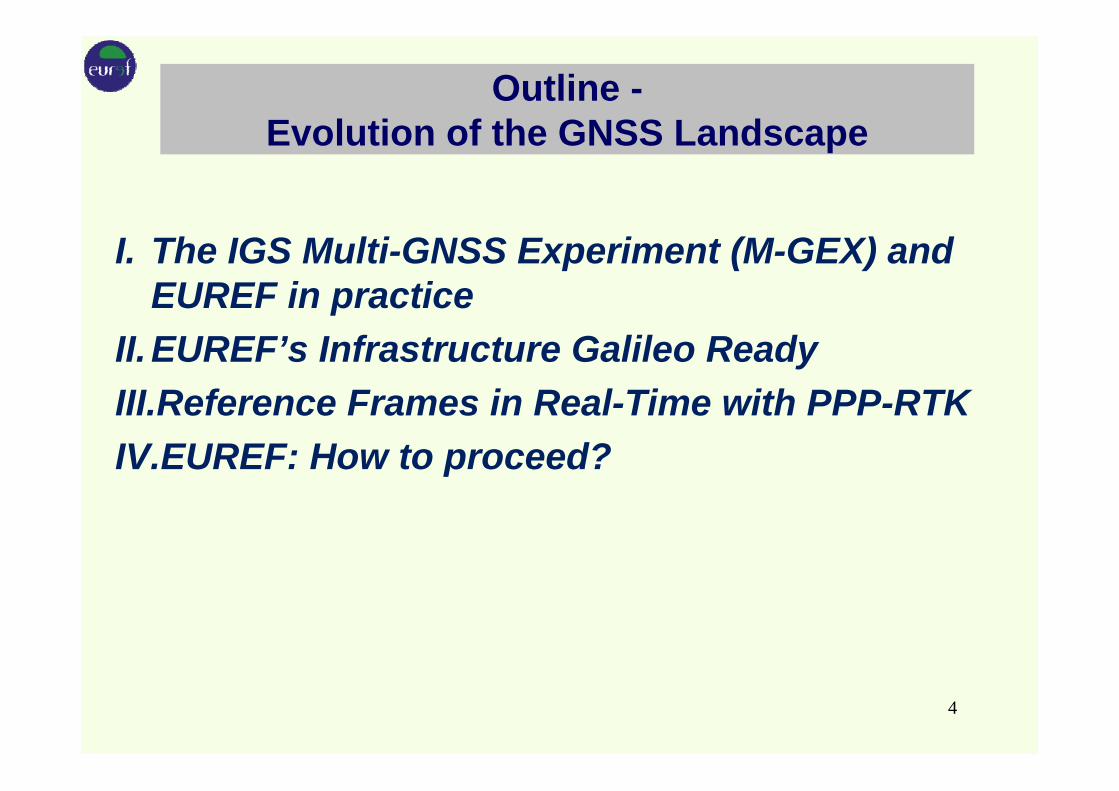
Outline -Evolution of the GNSS Landscape
I. The IGS Multi-GNSS Experiment (M-GEX) and EUREF in practice
II.EUREF’s Infrastructure Galileo ReadyIII.Reference Frames in Real-Time with PPP-RTKIV.EUREF: How to proceed?
4
I. The IGS Multi-GNSS Experiment (M-GEX) -MULTI-GNSS Activities in EUREF
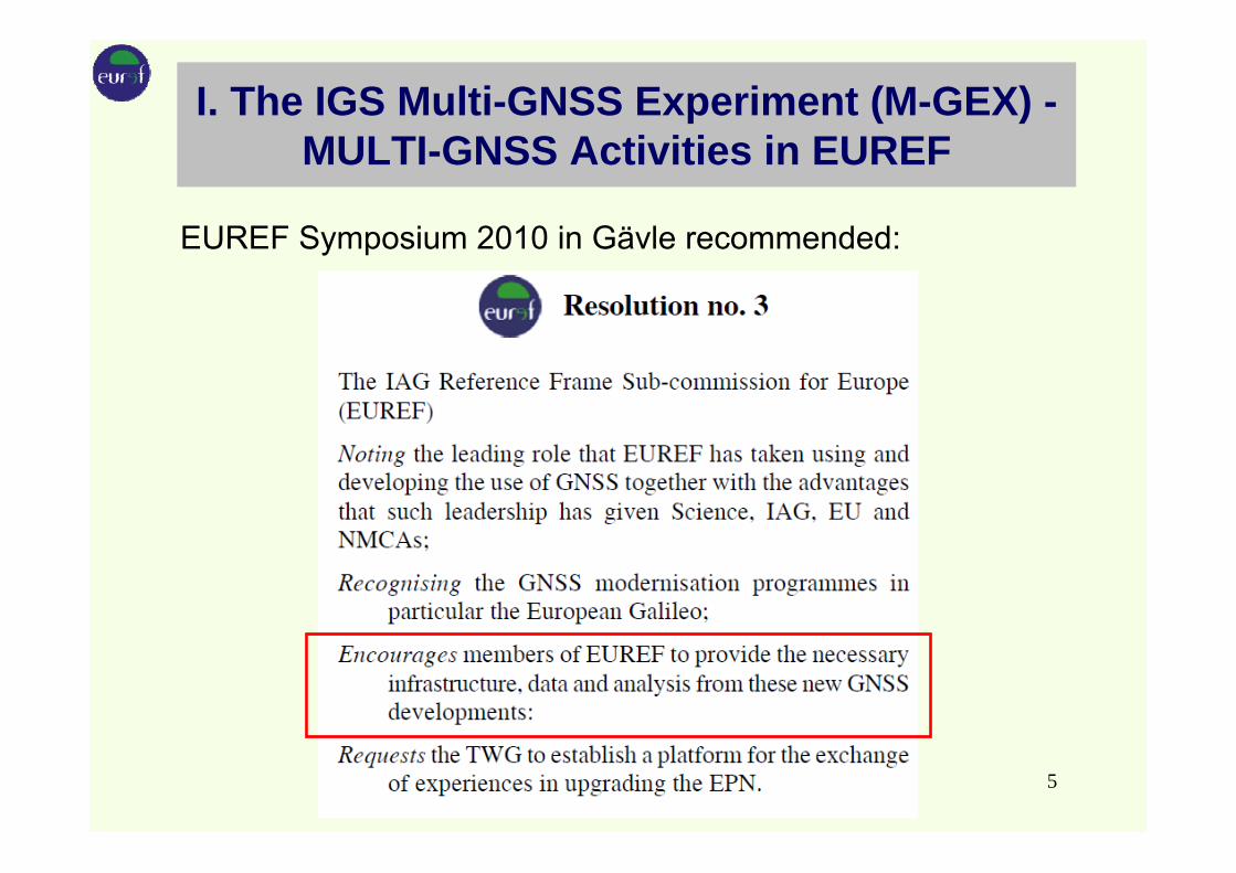
EUREF Symposium 2010 in Gävle recommended:
5

MULTI-GNSS Working Group EUREF
Topics:– Handling RINEX3.xx and/or RINEX2.xx and compatibility to
RTCM 'High Precision Multiple Signal Messages' (HP MSM) and procedure to implement it to the EPN
– Enhancing the EPN infrastructure by Multi-GNSS-ready receivers and antennas
– Enhancement method: double stations versus replacing existing analysis of GLONASS data (till now, only the minority of the EUREF analysis centers provide GPS-GLONASS products)
– Developing of software (post-processing and real-time) capable to handle multi-GNSS signals.
– Define the optimal procedure to have PCV calibrations available which are consistent between the GNSS systems
– Setting up a time schedule in order to plan the operational switch to RINEX3 which also is in line with IGS.
6

A Data Center for the IGS Multi-GNSS Experiment (M-GEX)
7
8
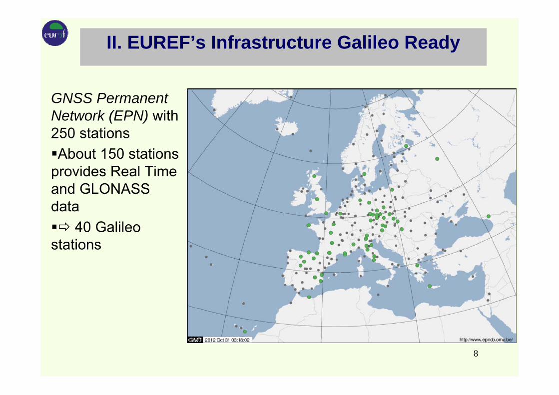
II. EUREF’s Infrastructure Galileo Ready
GNSS Permanent Network (EPN) with 250 stationsAbout 150 stations
provides Real Time and GLONASS data
40 Galileo stations

Usefull for stations with long time series
Double / Triple Station Concept Example Zimmerwald (swisstopo, Uni Bern)
GPS(since 1991)
GPS + GLONASS(since 2007)
MULTI GNSS(since 2011)
9
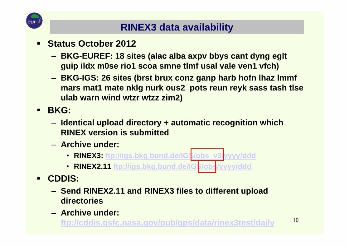
RINEX3 data availabilityStatus October 2012– BKG-EUREF: 18 sites (alac alba axpv bbys cant dyng eglt
guip ildx m0se rio1 scoa smne tlmf usal vale ven1 vfch)– BKG-IGS: 26 sites (brst brux conz ganp harb hofn lhaz lmmf
mars mat1 mate nklg nurk ous2 pots reun reyk sass tash tlse ulab warn wind wtzr wtzz zim2)
BKG: – Identical upload directory + automatic recognition which
RINEX version is submitted– Archive under:
• RINEX3: ftp://igs.bkg.bund.de/IGS/obs_v3/yyyy/ddd• RINEX2.11 ftp://igs.bkg.bund.de/IGS/obs/yyyy/ddd
CDDIS: – Send RINEX2.11 and RINEX3 files to different upload
directories– Archive under:
ftp://cddis.gsfc.nasa.gov/pub/gps/data/rinex3test/daily 10

III. Reference Frames in Real-Time with PPP-RTK
Why is EUREF Involved in Real-Time GNSS?
Support research organizations, universities, national mapping and cadastral agencies:
GNSS performance monitoringProviding precise positioning data and informationRapidly detecting, locating, and characterizing hazardous events such as earthquakes and tsunamisGeophysical hazard detection and warning systemsSpace weather forecasting
11

IGS Real-time GNSS Service
Real-time IGS Working Group since 2001Real-time Pilot Project since 2007Analysis Centers:BKG, CNES, CTU, DLR, ESA, Geo++, GMV, GZF, NRCan, WuhanIGS permanent RT service announced
12

Further RTCM Standardization for PPP
Will add messages for global ionosphere and phase biases to allow Ambiguity Resolution Will add troposphere info to allow PPP-RTK through Regional AugmentationsApproach requires access to a net like EUREF’s EPNApproach requires dense CORS networks from National Mapping Agencies
13

Reference Frames in Real-Time
Local RTK networks−better realisation of ETRS89 in all countries− long term maintenance of ETRS89 also in tectonically affected areas−a few cm accuracy within a few observation epochs− local reference stations and reference frames realization−no activity from EUREF in this domain
PPP-RTK−PPP is global approach−provide and apply precise SSR information−concept doesn’t request local reference stations−global reference frame realization; if needed transformed to regional or
local reference frames
• Added value: basic input for science and safety (e.g., tectonic risk assessment)
14

EUREF Real-Time Data Streams
15

EUREF Real-Time Product Streams
16

PPP-RTK & Open Standards
− Symposium, March 2012 BKG Frankfurt, 190 participants, 34 countries
− RT Workshop at the SIRGAS Symposium, Oct. 2012, Concepcion, Chile, 20 countries
17

IV. EUREF: How to proceed? Summary
EUREF supports all satellite navigation systems− data archive extended by RINEX version 3− GLONASS recommended in analysis guidelines− website at EPN central bureau ready for multi-GNSS
EUREF established real-time services− data and product streams− permanent PPP monitoring− development of tools, e.g., BNC
EUREF organizations take part in Galileo developments− Galileo reference frame− Galileo geodetic working group
18

EUREF: How to proceed?
EPN stations shall configured, where possible, with Galileo and GPS L5 signals ready receiversRegional and local densification of RT infrastructure testing of real-time precise point positioning (PPP) in the ETRS89 with recent available corrections in the RTCM standard for satellite orbits, clocks and biasesHelp in developing Open Standard for PPP with Ambiguity Resolution and PPP with Regional AugmentationSetup/Maintain independent European continental PPP service resources in cooperation with NMAsConvince manufacturers to support RTCM SSM messages in receiver firmware
19

NMAs: How to proceed?
Today’s Network RTK resources will not become obsolete, PPP-RTK just develops towards an alternativePick up EUREF´s PPP product for further dissemination through national Ntrip resourcesTest & validate EUREF´s PPP in their countries, Open Source software available through BNC and RTKLIBConsider making use of EUREF´s real-time product part of the national real-time product portfolio
EUREF prepare a Multi-GNSS-RT-Service
20
![Galileo - Manuale d'usogalileo-ofrm.ised.it/galileo/Galileo - Manuale utente.pdf · Manuale d’uso [OFR] - Progetto GALILEO - Manuale d’uso Documento di proprietà di ISED S.p.A.](https://static.fdocuments.net/doc/165x107/5b7292867f8b9a95348d2403/galileo-manuale-dusogalileo-ofrmiseditgalileogalileo-manuale-manuale.jpg)