EMEP and WRF (EMEP4UK) Brief introduction€¦ · EMEP and WRF (EMEP4UK) Brief introduction Massimo...
16
EMEP and WRF (EMEP4UK) Brief introduction Massimo Vieno Air Pollution Modeller Natural Environment Research Council, Centre for Ecology and Hydrology, Visiting scientist University of Edinburgh,School of Geosciences Email: [email protected]
Transcript of EMEP and WRF (EMEP4UK) Brief introduction€¦ · EMEP and WRF (EMEP4UK) Brief introduction Massimo...

EMEP and WRF (EMEP4UK) Brief introduction
Massimo Vieno Air Pollution Modeller Natural Environment Research Council, Centre for Ecology and Hydrology, Visiting scientist University of Edinburgh,School of Geosciences
Email: [email protected]

EMEP-WRF interface
Land use
Meteorological
driver
Emissions
GIS
Arc Info
script WRF
UK NAEI 1 km
EMEP 50 km
WRF/EMEP
interface
LANDUSE (WRF)
EMISSIONS
WRF 3.1
Model input
EMEP4UK
ENTEC 5 km R and NCL
analysis reference: Vieno et. al., 2010 ACP

Variables needed by the EMEP model
From the EMEP rv4.3 user guide
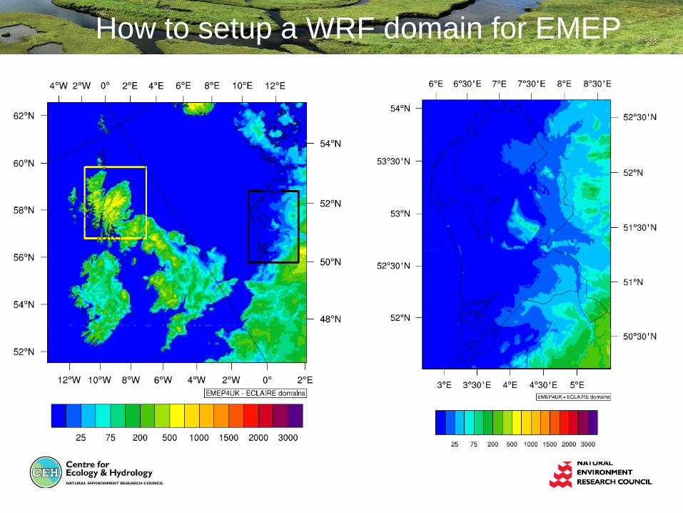
How to setup a WRF domain for EMEP

WRF setup to match the EMEP model domain
Setting the domain and sub-domain GRID setup
&geogrid
parent_id = 1,1,2,3,3,
parent_grid_ratio = 1,5,2,5,5,
i_parent_start = 1,65,25,40,210,
j_parent_start = 1,40,15,130,105,
e_we = 171,171,271,321,261,
e_sn = 134,161,271,371,371,
dx = 50000,
dy = 50000,
map_proj = 'polar',
ref_lat = 57,
ref_lon = 6,
truelat1 = 60,
truelat2 = 90,
stand_lon = -32,
/
A 4 steps procedure to setup a new WRF domain:
1. Define a model coarse domain and any nested domains – geogrid.exe
2. Extract meteorological fields from GRIB data sets (NCEP or ECMWF) – ungrib.exe 3. Horizontally interpolate meteorological fields to the model domains – metgrid.exe 4. Vertically interpolate the meteorological fields and if required setting the data for nudging – real.exe ...Running the WRF model... - wrf.exe

August 2008 – Scotland and Netherlands

How good are the main met variables?
• Temperature seems to be ok
• Wind speed and direction ok-ish
• Precipitation timing ok but problem with
magnitude - also some issues on fine domain

Temperature vs. UK AWS MIDAS
Example of 2001 3-hourly WRF calculated surface temperature for Bedford

2m Temperature bias for all sites... Model-observations annual average bias
2001 2002 2009
............
Some sites are consistently underestimate or overestimate 2m temperature

Temperature : WRF 3.1 – 2009 ~200 sites across the UK
Site height ~1200 m WRF 5 km2 grid ~500 m
WRF calculate 2m T as if was sea!

Does high res help with elevated sites?
• WRF 3-hourly Meteorology
• 2 months of computing time 80 processors
• Meteorology – UK analysis (MIDAS 190 UK sites)
1 km2 Scotland 5 km2 UK 50 km2 Europe

Way to improves....higher resolution
CAIRNGORM SUMMIT 1245 m
Grid size Model WRF Obs MIDAS Bias Slope R2
50 km2 6 0.9 -5.1 0.91 0.8
5 km2 3.5 0.9 -2.6 0.94 0.9
1 km2 2.8 0.9 -1.9 0.95 0.9
50 km2 grid
1 km2 grid

Wind speed - direction
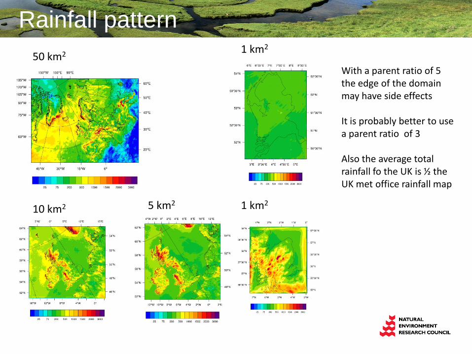
Rainfall pattern
50 km2
10 km2 5 km2
1 km2
1 km2
With a parent ratio of 5 the edge of the domain may have side effects It is probably better to use a parent ratio of 3 Also the average total rainfall fo the UK is ½ the UK met office rainfall map

Non standard EMEP domain setup
• Creating the emissions for the relevant scale (<5 km2)
• Re-projection of natural emissions (i.e. DMS)
• Default land cover (.nc) not fine enough for <5 km2 domain – I use WRF-MODIS instead
• Perhaps WRF MODIS derived land cover should always be use in EMEP-WRF
Emissions example

Model validation specific to the UK
AURN vs. EMEP4UK
>90 sites across the
UK for hourly ozone,
NOx, SO2, PM25
Not all site measure
everything