protecting consumers from abusive overdraft fees - U.S. Government

North Kings Groundwater Sustainability Agency Projects and Management Actions Groundwater Sustainability Plan
Page 6-1
6 Projects and Management Actions to Achieve Sustainability
Regulation Requirements:
§354.44(a) Each Plan shall include a description of the projects and management actions the Agency has determined will achieve the sustainability goal for the basin, including projects and management actions to respond to changing conditions in the basin. (b) Each Plan shall include a description of the projects and management actions that include the following:
(1) A list of projects and management actions proposed in the Plan with a description of the measurable objective that is expected to benefit from the project or management action. The list shall include projects and management actions that may be utilized to meet interim milestones, the exceedance of minimum thresholds, or where undesirable results have occurred or are imminent. The Plan shall include the following: (A) A description of the circumstances under which projects or management actions shall be implemented, the criteria that would trigger implementation and termination of projects or management actions, and the process by which the Agency shall determine that conditions requiring the implementation of particular projects or management actions have occurred. (B) The process by which the Agency shall provide notice to the public and other agencies that the implementation of projects or management actions is being considered or has been implemented, including a description of the actions to be taken. (2) If overdraft conditions are identified through the analysis required by Section 354.18, the Plan shall describe projects or management actions, including a quantification of demand reduction or other methods, for the mitigation of overdraft. (3) A summary of the permitting and regulatory process required for each project and management action. (4) The status of each project and management action, including a time-table for expected initiation and completion, and the accrual of expected benefits. (5) An explanation of the benefits that are expected to be realized from the project or management action, and how those benefits will be evaluated. (6) An explanation of how the project or management action will be accomplished. If the projects or management actions rely on water from outside the jurisdiction of the Agency, an explanation of the source and reliability of that water shall be included. (7) A description of the legal authority required for each project and management action, and the basis for that authority within the Agency. (8) A description of the estimated cost for each project and management action and a description of how the Agency plans to meet those costs. (9) A description of the management of groundwater extractions and recharge to ensure that chronic lowering of groundwater levels or depletion of supply during periods of drought is offset by increases in groundwater levels or storage during other periods.
(c) Projects and management actions shall be supported by best available information and best available science. (d) An Agency shall take into account the level of uncertainty associated with the basin setting when developing projects or management actions.
Draft

North Kings Groundwater Sustainability Agency Projects and Management Actions Groundwater Sustainability Plan
Page 6-2
6.1 Introduction
The NKGSA member agencies and entities have agreed to have each groundwater pumping entity mitigate for the estimated net impact of their pumping. As discussed in the water budget section, groundwater pumping outside one of the municipal systems but within the boundary of FID, International Water District or Garfield Water District will be the responsibility of FID, International Water District or Garfield to ensure sustainability. Groundwater pumping outside of all other agencies will be the responsibility of the County of Fresno to mitigate. The agencies within the NKGSA have chosen this responsibility method in order to provide an equitable method of mitigation that is based on impact of actions by each agency, and to allow each agency to control its own methods of mitigation and implementation. The NKGSA will provide the ongoing monitoring of impacts by agency, and oversee each agency to ensure mitigation requirements are met. The NKGSA is developing an initial policy for estimating groundwater impact caused by pumping. . The groundwater impact will be based on a combination of native safe yield from precipitation and river/stream seepage, groundwater pumping and groundwater recharge. This estimate will continue to be evaluated and may be modified as more information is collected. Each agency is responsible for identifying projects and programs to mitigate for their estimated impact. The agencies have a variety of tools that can be used to achieve sustainable groundwater management that fall into two primary categories: 1) Project development for water supply augmentation; and 2) management actions for demand reduction. As municipal systems expand their service area, the new areas will be added to the responsibility of these agencies. The first priority of each agency is to develop projects that augment the water supply through the use of surface water to meet demands, or provide groundwater recharge within the area of extraction. If project development is not able to achieve the interim sustainability milestones, then management actions or programs will be needed. The agency’s projects described herein primarily focus on using available surface water supplies within the NKGSA to reduce the impacts of groundwater pumping. Alternatively, management actions have been identified that primarily focus on reducing water demand, along with increased data collection and associated actions including education and outreach, regulatory policies, incentive-based programs, and enforcement actions.
6.2 Projects
Each agency within the NKGSA has identified projects to meet the initial estimate of impact on groundwater. Each agency developed and submitted a project information form to the NKGSA for review and incorporation into the GSP. Each project was reviewed by a subgroup of the Technical Subcommittee for consistency and justification. The current projects are summarized in Table 6-1, sorted by milestone year implementation. The table includes a listing of each of the required elements for a project under the regulations. A more detailed description of each project is included in the Project Information Forms, included in Appendix 6-A.
Draft

North Kings Groundwater Sustainability Agency Projects and Management Actions Groundwater Sustainability Plan
Page 6-3
The projects are in various stages of development, ranging from conceptual level to projects that are ready for construction. Thus, a different level of investigation has been completed for each project, ranging from preliminary conceptual projects with limited information, to projects with a feasibility level design completed, to projects that are “shovel ready”, which is defined as having complete environmental documentation and complete design plans and specifications. Projects discussed in this Plan will remain a part of the potential projects that the NKGSA’s agencies may choose to implement; however, as additional information is gathered other projects may be identified and considered in the future that have a higher yield or lower cost than the currently envisioned projects. This list will continue to be updated and modified by each of the agencies and the updates provided to the NKGSA on an annual basis. All management actions will be supported by the best available information and the best available science. The projects currently considered would yield an estimated average annual volume of approximately 200,000 AF/year if fully implemented as envisioned. However, it is important to note that a significant amount of the project yield identified in the project list will utilize surface water previously delivered to growers, now delivered to City of Fresno (through a cooperative agreement between the City and FID) that has historically had limited surface water use capability.
Draft

Page 6-4
North Kings Groundwater Sustainability Agency Projects and Management Actions Groundwater Sustainability Plan
Table 6-1 NKGSA Currently Identified Projects
354.44(a) 354.44(b)(2)&(5) 354.44(b)(2)&(5) 354.44(b)(2)&(5) 354.44(b)(4) 354.44(b)(4) 354.44(b)(4) 354.44(b)(8)
# Agency to Implement
Project or Management Action Title
Description Description of how benefit was determined Quantified Project Benefit
Project Benefit Units
Start Date Completion Date
Completion by Milestone Year
Cost Estimate
10 City of Fresno Residential Water Meter Retrofit Project
In 2004, California passed State Assembly Bill 514, which requires "urban water suppliers" who receive water from the federal CVP through existing USBR water service contracts, install water meters on all residential service connections on or before January 1, 2013. The City maintains a contract for 60,000 acre feet of surface water every year from the CVP through the USBR. To comply with this bill and to take acts to reduce water consumption all residential services will be equipped with meters.
Residential meter installation contracts commenced in 2010 and run through the end of 2012. Per capita water consumption from 2007 through 2011 averaged 277 gpcd. Per capita consumption after meters were installed, excluding the drought period of 2012-2016, averages 201 gpcd (2017 & 2018). The population at the end of 2011 was 513,358. Applying the per capita water consumption values from before and after meter installation yields a 43,600 AF reduction for the base 2011 population.
43,600
AF/yr 2010 2012 2015 $ 76,829,600
11 City of Fresno
T-3 Surface Water Treatment Facility
This project is for the construction of a 3 million gallon water storage tank and 4-MDG surface water treatment facility (with possible future expansion to 8-MGD). The project will include, engineering & design, construction of tank, booster pumps, operations and treatment buildings, and associated site improvements. As development continues in the southeast region of Fresno, the need for supplemental water system infrastructure and production is required to meet peak summertime demands. The project goal is to utilize surface water supplies to meet these new demands rather than groundwater.
Production yield is based on the treatment plant running 180-days per year at a rate of 4-MGD. Actual production may vary depending on supply availability and other factors.
2,210
AF/yr 2011 2013 2015 $ 21,819,800
9 City of Fresno
Southwest Reclamation Facility and Distribution System
As part of the City's long-term goal to utilize resources sustainably the development of a recycled water program will be key. This project includes the design and construction of an initial 5-MGD tertiary treatment facility and transmission and distribution system. The reclaimed water produced and distributed in the southwest region will provide a direct potable water offset, thus reducing the reliance on and use of groundwater supplies.
Production yield is based on the tertiary treatment facility operating 335-days per year at a rate of 5-MGD.
5,140
AF/yr 2014 2019 2020 $ 114,600,000
Draft

Page 6-5
North Kings Groundwater Sustainability Agency Projects and Management Actions Groundwater Sustainability Plan
354.44(a) 354.44(b)(2)&(5) 354.44(b)(2)&(5) 354.44(b)(2)&(5) 354.44(b)(4) 354.44(b)(4) 354.44(b)(4) 354.44(b)(8)
# Agency to Implement
Project or Management Action Title
Description Description of how benefit was determined Quantified Project Benefit
Project Benefit Units
Start Date Completion Date
Completion by Milestone Year
Cost Estimate
12 City of Fresno Nielsen Recharge Facility
This project is to expand the City's groundwater recharge program and includes land acquisition, development of new recharge basins, structures and conveyance systems such as pipelines, canal turnouts, metering systems, and interties. The project goal is to optimize groundwater recharge efforts so as to balance groundwater extractions as laid out in the City's 2014 Metropolitan Water Resources Plan.
The provided value is the measured flow that was delivered to the facility last year for groundwater recharge purposes.
3,500
AF/yr 2015 2016 2020 $ 3,657,000
13 City of Fresno
Southeast Surface Water Treatment Facility
Design, construction, start-up, and commissioning of the new Southeast Surface Water Treatment Facility (SESWTF) and associated large diameter transmission mains. New facility is required to treat surface water diverted from the Kings River through canal and raw water pipeline system. Historically, the City has largely relied on groundwater to meet municipal water demands. The SESWTF will utilize surface water supplies and permit the balanced use of both groundwater and surface water, thus greatly reducing groundwater extractions.
Production yield is based on the plant running 335-days per year at a rate of 80-MGD. Actual production may vary depending on supply availability and other factors.
82,240
AF/yr 2014 2019 2020 $ 314,600,000
1 Bakman Water Meter Project
Bakman Water Company is installing water meters on all of its approximately 2,450 service connections in its service area. The project will provide an estimated 20% reduction in usage which is approximately 870 acre-feet per year of benefit. Bakman has initiated meter installation, however is including in the GSP because the benefits of the project are just starting to be observed.
The estimate of 20% conservation is based on recent studies and local case studies from the City of Fresno, Clovis and Kerman that have observed 20-26% reduction in usage from leakage reduction and conservation measures.
870
AF/yr 2015 2025 2025 $ 2,907,000
2 Biola Community Services District
Biola Groundwater Recharge Project
Construct a canal turnout and pipeline to deliver surface water from FID Herndon Canal to an existing storm drain basin that will be enlarged to hold 30 acre-feet of water.
The basin will be capable of percolating 2.5 a-f/day based on percolation tests. Assuming 60 days per year for percolation time, the total amount is 150 a-f /yr.
150
AF/yr 2020 2021 2025 $ 705,000
3 City of Clovis Marion Recharge Basin Improvements
Improve recharge at the Marion Recharge Basins through a variety of measures to increase percolation including routine maintenance and capital projects.
Quantity is estimated. The City is entertaining the use of a proprietary product and/or installing dry wells to increase groundwater percolation.
2,500
AF/yr 2020 2021 2025 TBD
Draft

Page 6-6
North Kings Groundwater Sustainability Agency Projects and Management Actions Groundwater Sustainability Plan
354.44(a) 354.44(b)(2)&(5) 354.44(b)(2)&(5) 354.44(b)(2)&(5) 354.44(b)(4) 354.44(b)(4) 354.44(b)(4) 354.44(b)(8)
# Agency to Implement
Project or Management Action Title
Description Description of how benefit was determined Quantified Project Benefit
Project Benefit Units
Start Date Completion Date
Completion by Milestone Year
Cost Estimate
6 City of Clovis Clovis SWTP Pretreatment
This project will construct effective pretreatment for the existing 22.5 MGD surface water treatment plant (SWTP) so that the plant can continuously run during times of high turbidity in the raw water source.
On average, the SWTP produces approximately 60% of the City's total water demand during the winter and spring months. It is estimated that the plant would be able to produce an average of an additional 125 MG per month over a 5 month (Jan - May) period which equates to 2,000 AF per year.
2,000
AF/yr 2020 2021 2025 $ 1,025,000
8 City of Fresno
Northeast Surface Water Treatment Facility Expansion
The NE-SWTF Expansion Project is part of the City's near-term program to attain and maintain the sustainable use of water resources. This project is for the 30-MDG expansion of the existing surface water treatment facility for a total capability of 60-MGD. To enable water from the expansion to reach further into the City large diameter transmission mains will also be constructed. This project will meet future growth demands and ensure groundwater utilization attains and remains at safe-yield levels.
Production yield is based on the plant expansion running 335-days per year at a rate of 30-MDG (this is only for the expansion). Actual production may vary on supply availability and other factors.
30,840
AF/yr 2021 2025 2025 $ 161,500,000
14 City of Kerman
Lions Park Groundwater Recharge project
The City's Lion's Park Stormwater Basin serves the majority of the west side of the City. The stormwater collection system for the Basin currently includes an intertie with FID's Siskiyou Lateral No. 146 pipeline at a structure on the west side of Siskiyou Avenue, north of Kearney Boulevard. Currently, the intertie only allows for occasional overflows via overtopping of a weir into the City's stormwater collection system. The proposed project would install the valving, piping, and metering equipment necessary to allow for regular distribution of FID surface water into the City's stormwater collection system, to be conveyed to the Lion's Park Stormwater Basin for groundwater recharge purposes
The estimated recharge volume was calculated based on the basin size, percolation/recharge rate, and number of days water would be available for recharge. The Basin is anticipated to be maintained approximately half full, resulting in a wetted area of 5.79 acres. The percolation/recharge rate used, 0.25 feet per day, is from master-planning and permitting done for the City's WWTP, which has similar soil characteristics. The City assumed 135 days per year of available surface water from FID.
195
AF/yr 2021 2021 2025 $ 41,000 Draf
t

Page 6-7
North Kings Groundwater Sustainability Agency Projects and Management Actions Groundwater Sustainability Plan
354.44(a) 354.44(b)(2)&(5) 354.44(b)(2)&(5) 354.44(b)(2)&(5) 354.44(b)(4) 354.44(b)(4) 354.44(b)(4) 354.44(b)(8)
# Agency to Implement
Project or Management Action Title
Description Description of how benefit was determined Quantified Project Benefit
Project Benefit Units
Start Date Completion Date
Completion by Milestone Year
Cost Estimate
15 FID Central Basin Recharge Project
The Fresno Irrigation District’s Central Basin Project is approximately 90-acres of groundwater banking and recharge facilities at three locations that will yield a usable surface water supply as well as recharge the aquifer. The project includes approximately 90-acres of recharge basins at three locations and multiple monitoring wells. The project will expand the available water supply to the region. Kings River flood water and local flood water conveyed through FID’s canals will be delivered to the basin sites for recharge. This project component is a continuation of the collaboration between FMFCD and FID to provide flood protection and better manage the region’s water resources. The project will address several current needs facing the region, including improving regional water self-reliance and providing additional surface and groundwater storage to adapt to climate change. The project will also contribute to water security, create a conjunctive use facility, increase water supply reliability, provide needed groundwater recharge to slow/prevent groundwater contaminant plume migration, decrease risk of flooding, facilitate the Kings River Fisheries Management program and create increased wetted area.
Consistent with the expected benefits stated in the project's Proposition 1 grant application, an estimation of the recharge potential of the project was originally calculated based on the available surface supply, basin volume (360AF, 90 wetted acres at 4 feet deep), diversion capacity (100cfs) and assumed infiltration rate of 0.25ft/day. Figure 8 shows the total potential recharge for the basin using these assumptions for the years data was available. (Of note, Fancher Creek data after 2000 was not available at the time of this application). A 50-year estimation was then prepared and is included as Figure 9 in the attached report. The recharge potential using only the Kings and Fancher water supplies was estimated to be 2,592 AF/yr. It is important to understand that the 2,592AF/yr is an average number. In dry years, the amount recharged using these surface water supplies may be zero, however in wet years, the amount of water recharged will exceed 6,000AF. This is clearly indicated in both Figures 8 and 9 of the attached report. After the original expected annual benefit was calculated for the Proposition 1 grant application, the project was later reduced in size from 100 acres to 90 acres. However, using a still conservative recharge estimate of 0.3 ft/day infiltration rate, the project at three sites is estimated to recharge 2,717 AF/yr, which exceeds the originally planned estimate of 2,592 AF/yr. The 2,592 AF/yr will still be used as a conservative estimate.
2,592
AF/yr 2018 2020 2025 $ 6,500,000
Draft

Page 6-8
North Kings Groundwater Sustainability Agency Projects and Management Actions Groundwater Sustainability Plan
354.44(a) 354.44(b)(2)&(5) 354.44(b)(2)&(5) 354.44(b)(2)&(5) 354.44(b)(4) 354.44(b)(4) 354.44(b)(4) 354.44(b)(8)
# Agency to Implement
Project or Management Action Title
Description Description of how benefit was determined Quantified Project Benefit
Project Benefit Units
Start Date Completion Date
Completion by Milestone Year
Cost Estimate
16 FID Wagner Recharge Basin
The project is a 60-acre groundwater recharge basin, including earthwork and structures. The project will provide approximately 200 AF of flood water surface storage and recharge approximately 2,300 AF/year annual average. Floodwater and other available surface waters will be delivered to the new basin and recharged into the aquifer. The primary purpose of this project is to halt, and ultimately reverse, the current groundwater overdraft in the area by utilizing unused regional flood water supplies available to FID and provide for sustainable management of surface and groundwater.
The project would allow FID to increase its use of Kings River surface water supplies through the project. The project will capture, store, and recharge surface water normally lost from the Kings River, allowing for sustained management. Recharging the water that is diverted into the project during wet years will help replenish the groundwater and can be stored to be used during dry years. The project will recharge water at the project site, putting 2,300 AF/year of water into the aquifer. The project will capture and recharge flood water lost to the region, and the recharged water will be available for pumping by nearby or new wells. The expected annual benefit was calculated using the actual recharge rates for FID's groundwater banking facilities (Waldron, Lambrecht, Empire, and Boswell). Attached is the project's Proposition 1 grant funding pre-application for more details.
2,300
AF/yr 2019 2021 2025 $ 4,276,780
17 FID Savory Pond Expansion
FID will expand the expanding Savory Pond to an approximately 30-acre recharge basin near the corner of Lincoln & Chestnut Avenues. The project will provide an estimated 1,200AF per year of groundwater recharge to the aquifer. The project will include construction of basin levees, new turnout and measurement into the basin, fencing and other basin improvements.
The 0.4 feet per day is considered conservative based on recharge rates at the existing site and other nearby basins. 100 days of delivery of water to the recharge basin is an average annual amount that is also conservative based on available FID surface water supplies.
1,200
AF/yr 2020 2022 2025 $ 2,000,000
18 FID On-Farm Recharge Program
FID will establish a program to offer and encourage growers to perform on-farm recharge during wet years when would otherwise be lost to the region.
The program is in the conceptual phase and will be dependent on grower's willing to take surface water during wet periods. Floodwater is typically available every 3-4 years. A conservative estimate of 40,000AF of supply could be available for this program, netting an average annual benefit of 10,000af/yr.
10,000
AF/yr 2025 2025 2025 $ 100,000
Draft

Page 6-9
North Kings Groundwater Sustainability Agency Projects and Management Actions Groundwater Sustainability Plan
354.44(a) 354.44(b)(2)&(5) 354.44(b)(2)&(5) 354.44(b)(2)&(5) 354.44(b)(4) 354.44(b)(4) 354.44(b)(4) 354.44(b)(8)
# Agency to Implement
Project or Management Action Title
Description Description of how benefit was determined Quantified Project Benefit
Project Benefit Units
Start Date Completion Date
Completion by Milestone Year
Cost Estimate
19 Garfield Water District
Ricchiuti Recharge Basin Project
The Garfield Water District, as a part of its current reorganization, proposes to annex into the District the remaining portion of APN 580-040-01. Said parcel contains an existing five (5) acre basin, which is owned by Frances M. and Partick V Ricchiuti. Following annexation, the District proposes to construct a delivery connection from its distribution system to the existing basin to allow for the delivery of surface water for recharge into the basin. Basin improvements include the installation of a metered turnout facility and a conveyance pipeline.
The estimate of recharge benefit is based on the basin size, multiplied by the anticipated recharge rate, multiplied by the number of days water is available for recharge. The five (5) acre site is anticipated to have an infiltration/percolation rate of .625 feet per day with water being available an average of 240 days per year.
150
AF/yr 2020 2020 2025 $ 175,000
20 Malaga County Water District
Basin CF - Stormwater Recharge and Flood Protection Project
This project will construct an intertie (connection) between FMFCD’s existing Basin “CF” with FID's Washington Colony Canal No. 15 to allow for the delivery of surface water for recharge into the basin. Basin improvements include a basin pump station, telemetry system, internal basin pipeline, basin relief pipeline, canal intertie structure and appurtenant facilities. The basin is used for local urban stormwater capture to prevent localized flooding. Currently, there is no pipeline to convey water from the nearby canal to the basin. The project will construct the intertie and is estimated to provide approximately 1,000 acre-feet per year.
The estimate of recharge benefit is based on the basin size, multiplied by the anticipated recharge rate, multiplied by the number of days water is available for recharge. The 20 acre site will have an approximately 18 acre wetted basin area and is anticipated to have an infiltration/percolation rate of 0.45 feet per day based on actual infiltration rates observed at other nearby FMFCD basins. For estimating purposes, it has been assumed that water will be available an average of 120 days per year.
970
AF/yr 2021 2021 2025 $ 1,072,036 Draf
t
Page 6-10
North Kings Groundwater Sustainability Agency Projects and Management Actions Groundwater Sustainability Plan
354.44(a) 354.44(b)(2)&(5) 354.44(b)(2)&(5) 354.44(b)(2)&(5) 354.44(b)(4) 354.44(b)(4) 354.44(b)(4) 354.44(b)(8)
# Agency to Implement
Project or Management Action Title
Description Description of how benefit was determined Quantified Project Benefit
Project Benefit Units
Start Date Completion Date
Completion by Milestone Year
Cost Estimate
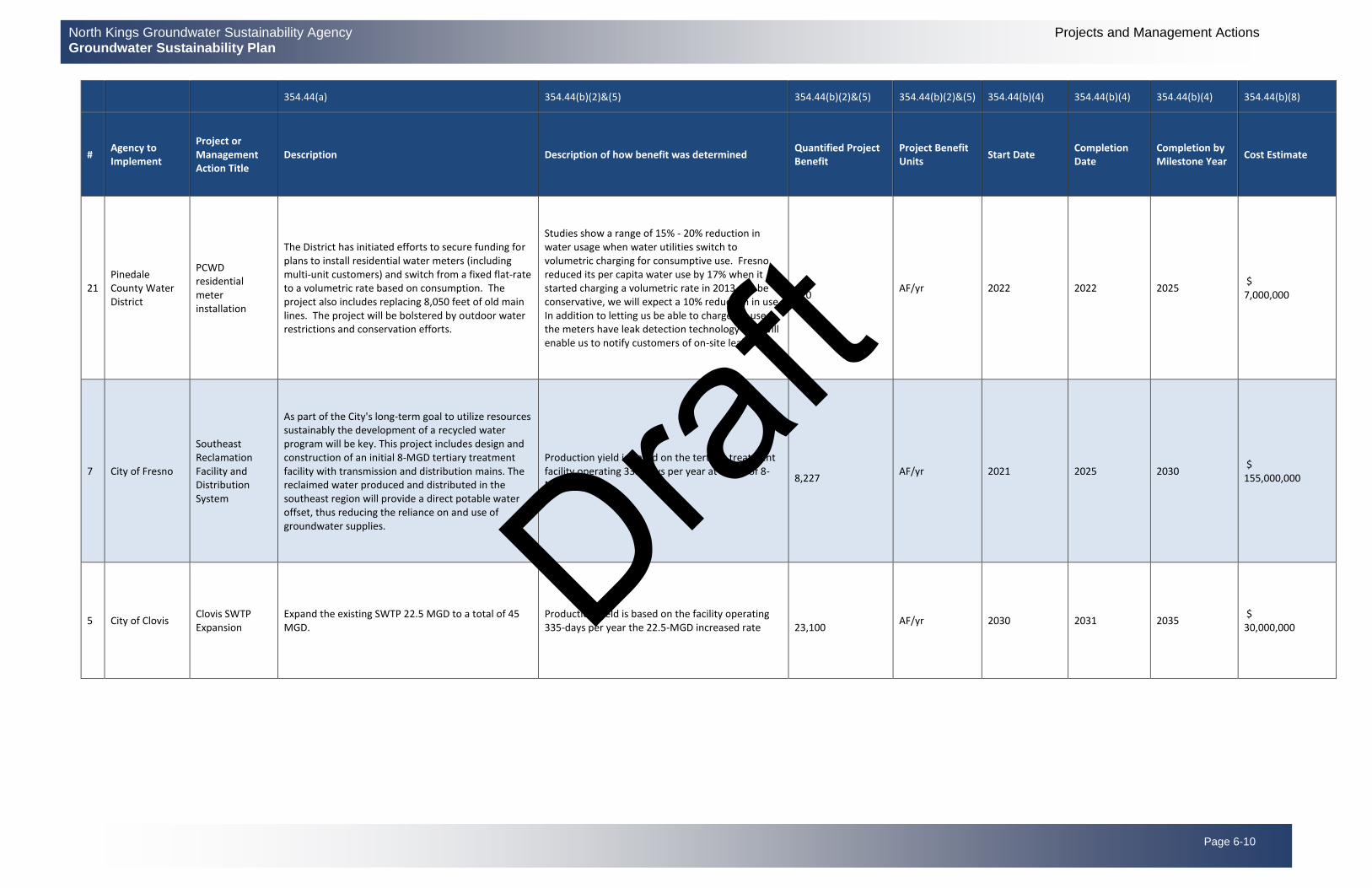
21 Pinedale County Water District
PCWD residential meter installation
The District has initiated efforts to secure funding for plans to install residential water meters (including multi-unit customers) and switch from a fixed flat-rate to a volumetric rate based on consumption. The project also includes replacing 8,050 feet of old main lines. The project will be bolstered by outdoor water restrictions and conservation efforts.
Studies show a range of 15% - 20% reduction in water usage when water utilities switch to volumetric charging for consumptive use. Fresno reduced its per capita water use by 17% when it started charging a volumetric rate in 2013. To be conservative, we will expect a 10% reduction in use. In addition to letting us be able to charge for use, the meters have leak detection technology that will enable us to notify customers of on-site leaks.
210
AF/yr 2022 2022 2025 $ 7,000,000
7 City of Fresno
Southeast Reclamation Facility and Distribution System
As part of the City's long-term goal to utilize resources sustainably the development of a recycled water program will be key. This project includes design and construction of an initial 8-MGD tertiary treatment facility with transmission and distribution mains. The reclaimed water produced and distributed in the southeast region will provide a direct potable water offset, thus reducing the reliance on and use of groundwater supplies.
Production yield is based on the tertiary treatment facility operating 335-days per year at a rate of 8-MGD.
8,227
AF/yr 2021 2025 2030 $ 155,000,000
5 City of Clovis Clovis SWTP Expansion
Expand the existing SWTP 22.5 MGD to a total of 45 MGD.
Production yield is based on the facility operating 335-days per year the 22.5-MGD increased rate
23,100
AF/yr 2030 2031 2035 $ 30,000,000 Draf
t

Page 6-11
North Kings Groundwater Sustainability Agency Projects and Management Actions Groundwater Sustainability Plan
354.44(a) 354.44(b)(2)&(5) 354.44(b)(2)&(5) 354.44(b)(2)&(5) 354.44(b)(4) 354.44(b)(4) 354.44(b)(4) 354.44(b)(8)
# Agency to Implement
Project or Management Action Title
Description Description of how benefit was determined Quantified Project Benefit
Project Benefit Units
Start Date Completion Date
Completion by Milestone Year
Cost Estimate
4 City of Clovis ST-WRF Expansion
Expand the existing 2.8 MGD Clovis Sewage Treatment/Water Reuse Facility (ST-WRF) to 5.6 MGD and then to 8.4 MGD
2.8 MGD equates to 3,100 AFY (Current) 5.6 MGD equates to 6,300 AFY (2030) 8.4 MGD equates to 9,400 AFY (2042)
9,400
AF/yr 2030 2042 2045 $ 40,200,000
Draft

North Kings Groundwater Sustainability Agency Projects and Management Actions Groundwater Sustainability Plan
Page 6-12
6.3 Management Actions
The NKGSA and its member agencies believe sustainability will be reached with the projects identified in Section 6.2, however a listing of management actions is included should they become necessary. Domestic water supply agencies are already obligated to consider demand reduction/conservation efforts during dry periods. These domestic supply agencies have identified their demand management actions in their Urban Water Management Plans. These management actions, as well as others are listed in this section as possible actions that may be required if conditions in the NKGSA worsen. Some management actions, such as education and outreach, will be initiated by the NKGSA as a whole, while most listed here will only be implemented if necessary, by the individual agencies within the NKGSA responsible to meet their mitigation requirements to remain sustainable. This Section discusses a suite of possible management actions the member and participating agencies may consider if the projects are not proving to reach sustainability. Not all management actions apply to each agency. The menu of management actions discussed below may not be implemented in a strictly linear fashion as numbered below as some management actions must be implemented before others can be achieved, and specific actions may not be implemented at all if sustainability is achieved through other actions. It is expected the NKGSA and its agencies will further develop management actions in response to stakeholder input on parallel timelines and adapt to the estimated schedules according to the best available information and best available science at any given time. The legal authority and basis for the management actions described in this GSP are outlined in the SGMA and related provisions. The management actions that may be considered by the NKGSA or its member agencies are shown in Table 6.2 and are discussed below.
Table 6-2 List of Management Actions
No. Category Action
EO-1 Education and Outreach Regular Communication
EO-2 Education and Outreach Non-Routine Responses to Minimum Threshold Exceedances
WH-1 Wellhead Requirements Registration of Extraction Facilities
WH-2 Wellhead Requirements Installation of Wellhead Meters, Sounding Tubes and Water Quality Sample Ports
WH-3 Wellhead Requirements Self-Reporting of Groundwater Extraction, Level, and Water Quality
GA-1 Groundwater Allocation Groundwater Quantification Methods
GA-2 Groundwater Allocation Development of Groundwater Allocation Per Acre
GA-3 Groundwater Allocation Groundwater Allocation “Ramp-Down” Gradual Decrease
GA-4 Groundwater Allocation Groundwater Allocation “Adaptive Management” Approach
GP-1 Groundwater Pumping Restrictions Regulate Groundwater Exports
GP-2 Groundwater Pumping Restrictions Require New Developments to Prove Sustainable Water Supply
Draft

North Kings Groundwater Sustainability Agency Projects and Management Actions Groundwater Sustainability Plan
Page 6-13
No. Category Action
GP-3 Groundwater Pumping Restrictions Pumping Restrictions During Droughts
Education and Outreach Management Actions
EO-1 Regular Communication
The NKGSA and its member agencies and entities will continue to promote education and outreach to all beneficial users within the NKGSA as detailed in Section 2.5.
EO-2 Non-Routine Responses to Minimum Threshold Exceedances
In addition to regular correspondence, the NKGSA may also immediately notify member agencies of a Minimum Threshold (MT) exceedance as defined in Section 4.3. In an effort to provide communication and outreach, the notification may contain the following information:
• Description and location of the MT exceedance.
• Notice of increased frequency of water level and/or water quality monitoring.
• Non routine notices and responses when the water levels are between MO and MT.
• The potential effects to the member agency.
• The planned NKGSA response (i.e. trigger of specific projects and managements actions).
• A written reminder of the NKGSA powers and authorities granted in SGMA, as well as,
State intervention when Undesirable Results occur.
The regular correspondence and notice of MT exceedance may or may not generate a quantifiable groundwater demand reduction.
Table 6-3: Summary of Management Actions EO1 and EO2
Management Action No.:
EO1 and EO2
Measurable Objective(s) Addressed - 354.44(b)(1)
The measurable objectives would be the number of annual correspondence letters and MT exceedance notices that are mailed each year
Circumstances and Criteria for Implementation - 354.44(b)(1)(A)
The education and outreach management action may be developed and implemented shortly after the adoption of the GSP. The policy would remain indefinitely and be reevaluated every 5 years. A trigger for the end of this management action may be that another GSA management action or program provides comparable annual education letters and outreach notices.
Process for Public Notification - 354.44(b)(1)(B)
The process for public notification will be addressed by the consistent communication and outreach between the NKGSA and the groundwater extractor. The NKGSA will develop a system to initiate communication on a regular basis and will additionally respond to overdraft or non-compliance with minimum thresholds with escalating correspondence as deemed
Draft

North Kings Groundwater Sustainability Agency Projects and Management Actions Groundwater Sustainability Plan
Page 6-14
Management Action No.:
EO1 and EO2
necessary. The cost associated with NKGSA correspondence will be assessed on an annual basis.
Permitting and Regulatory Requirements - 354.44(b)(3)
No permits or regulatory requirements are anticipated for this Action.
Status and Schedule - 354.44(b)(4) Anticipated Start & Completion, Timeframe to accrue benefits
The education and outreach program with annual education letter and notice of MT exceedance has not been drafted. It is expected to commence shortly after the adoption of the GSP and be completed within 1 year. The initial focus will be the annual correspondence letter since the notices of MT exceedance may not occur for many years.
Evaluation of Benefits - 354.44(b)(5)
The NKGSA will use education and outreach opportunities to encourage active engagement, open lines of communication with interested and affected stakeholders, let them know the future opportunities for input, establish communication channels, and receive feedback on the GSP implementation process.
The expected benefits may mitigate overdraft by educating the public about the current use and quality of groundwater supplies. Without levying penalties, the NKGSA intends for all correspondence and mailed notices to educate extractors about the NKGSA’s monitoring practices, procedures, and enforcement capabilities. Other program benefits include the transparent and expeditious communication of NKGSA groundwater overdraft conditions, implementation of specific projects and managements actions, funding opportunities, and potential for State intervention if undesirable results occur.
How will the management action be accomplished? - 354.44(b)(6)
The annual correspondence and escalation letters will be accomplished by utilizing the in-house mailing database that the NKGSA will develop and maintain. All correspondence will be drafted by NKGSA staff and will be in accordance with the actions of the Board of Directors. Further detail regarding communication can be found in Section 2.5.
Estimated Costs - 354.44(b)(8)
The costs related to the education and outreach management action include one-time expenses and reoccurring annual expenses. The NKGSA has included an annual budget for ongoing communication and outreach. Individual member and participating agency expenses for outreach and communication will be the responsibility of those agencies.
Well Head Requirements Management Actions
Additional well requirements may be required to more effectively manage and understand the dynamic groundwater conditions. The Fresno County Public Health Department (FCPHD) permits well construction and the remaining member agencies manage new well construction within their respective city boundaries and do not allow new, private wells, to be constructed. Obtaining a well permit through FCPHD is currently a ministerial process, not requiring discretionary action or CEQA. The intent of this management action is to have the NKGSA work cooperatively with the FCPHD to
Draft
North Kings Groundwater Sustainability Agency Projects and Management Actions Groundwater Sustainability Plan
Page 6-15
modify well requirements without disrupting the current ministerial permit process. Additionally, the NKGSA would promote constant communication with the FCPHD and would seek to implement more monitoring responsibility. The NKGSA may request the County to augment the current well requirements set by the FCPHD and establish new permit criteria, enforce NKGSA policies, and require NKGSA approval of all permit paperwork before FCPHD permit issuance. The policy would affect permits to construct, deepen, destroy, recondition, or repair a well. In order to increase data collection, reporting, and ongoing groundwater management efforts, the additional well requirements policy may contain the following information:
• Registration of extraction facilities within the NKGSA.
• Require the installation of wellhead meters, sounding tubes, and water quality sample ports.
• Require the well owner to self-report groundwater extraction volumes, static water levels, and
water quality data.
The NKGSA may consider separating the additional well requirements management action into multiple policies or be silent on various bulleted components until the NKGSA deems them necessary. For example, the requirement of installing sounding tubes and water quality sample ports may be enacted before the requirement of a well flow meter. Further explanation and detail of the potential additional well requirements are continued below. The desired outcome of additional well permitting requirements is the ability to monitor groundwater extractions, water levels, and water quality in a thorough, accurate, and efficient manner across the NKGSA. The measurable objectives differ amongst the bulleted considerations. The NKGSA may also consider in the future a policy to curtail or prohibit the construction of new wells, in coordination with other local agency policies. This policy is not anticipated to be needed, but the NKGSA reserves the right to enact this policy if sustainability is not being reached or a certain area of the NKGSA is not adequately implementing measures to protect and sustain the aquifer. WH-1 Registration of Extraction Facilities
As stated in SGMA 10725.6, “a GSA may require the registration of a groundwater extraction facility within the management area of the GSA.” The NKGSA has greatly benefited from the current exchange of well information and use of the online DWR Well Completion Report Map Application tool found here: https://dwr.maps.arcgis.com/apps/webappviewer/index.html?id=181078580a214c0986e2da28f8623b37. However, through research of the proposed well monitoring network, the NKGSA understands many existing wells do not have well completion reports or have not been entered into the DWR database and may be absent from the existing records. The intent of registration of groundwater extraction facilities would be to complement existing well recordkeeping and ensure that the NKGSA can fully understand and quantify the potential impacts of groundwater decline. Coupled with the registration of extraction facilities, the NKGSA may invest in a complete well canvass study to verify the number of wells and presence of a flow meter. WH-2 Installation of Wellhead Meters, Sounding Tubes and Water Quality Sample Ports The NKGSA may require the installation of a flow meter on groundwater extraction facilities to provide more accurate quantities of groundwater extraction and serve as the nexus to other management actions. The policy would describe the acceptable types of flow measurement devices, installation standards and requirements, operation and maintenance requirements, and penalties for
Draft

North Kings Groundwater Sustainability Agency Projects and Management Actions Groundwater Sustainability Plan
Page 6-16
tampering, neglect, or misconduct. The NKGSA may also require the installation of a well sounding tube, airline, electric depth gauge, and/or other water level sensor for the purpose of measuring water levels throughout the NKGSA. The accurate and widespread collection of water level data will provide the NKGSA with the necessary information to monitor the success/failure of the GSP against the established Sustainable Management Criteria in Chapter 4. The policy would describe the acceptable types of water measuring devices and sample ports, installation requirements, and penalties for tampering, neglect, or misconduct. The installation must provide or allow for the accurate measurement of static groundwater level in feet below the ground surface. If applicable, the water measurement device must be routinely maintained by the well owner. Once the well construction, deepening, or destruction work was completed, the contractor would be required to provide a Notice of Completion, also known as a Well Driller’s Report or Well Log, within thirty (30) days of completion. The report would document that the work was completed in accordance with the County’s Well Standards Ordinance and NKGSA additional well requirements policy. WH-3 Self-Reporting of Groundwater Extraction, Level, and Water Quality
The NKGSA may require the well owner to self-report to the NKGSA the groundwater extraction volumes, static water levels, and water quality data twice per year, generally in March and October. The policy would describe the frequency of reporting, various methods of reporting, due dates, and specific instructions for data collection. If there is limited compliance with self-reporting, the NKGSA may elect to gather the appropriate data with their own staff. The policy would describe that the frequency of the reporting may be temporarily increased if minimum thresholds are exceeded.
Management Action No.: WH1 through WH3
Measurable Objective(s) Addressed - 354.44(b)(1) WH1: The measurable objective would be the number of documented extraction facilities. The
method of evaluation may be comparing the number of registered wells to the FCPHD and DWR well records.
WH2: The measurable objective would be the number of installed meters, sounding tubes and water quality sample ports. The method of evaluation would be reviewing the number of well permits and confirming whether meters, sounding tubes, and sample ports were installed.
WH3: The measurable objective would be number of received reports for each mailing cycle. The method of evaluation would be reviewing the number of responses from groundwater users analyzing data validity/accuracy, and filling data gaps.
Circumstances and Criteria for Implementation - 354.44(b)(1)(A) The current situation of critical groundwater overdraft leading to the unsustainable management
of groundwater resources justifies the implementation of additional well requirements. This policy requires the support and coordination of the member agencies for successful implementation. For existing wells, there may be extenuating circumstances where the installation of flow meter, sounding tube, and/or water quality sample port are not practical or financially advisable. The policy would remain indefinitely or until another GSA program serves the same purpose.
Process for Public Notification - 354.44(b)(1)(B) Educational correspondence regarding self-reporting of groundwater extractions would be
accomplished through direct communication between the well owner and the NKGSA. This
Draft

North Kings Groundwater Sustainability Agency Projects and Management Actions Groundwater Sustainability Plan
Page 6-17
Management Action No.: WH1 through WH3
will take place in the form of self-reporting and the monitoring of water level and water quality which is then compiled and distributed through each mailing cycle of correspondence mailings. Should the Board of Directors choose to adopt policy addressing WH-1-WH-3 the public will be notified through established NKGSA correspondence methods as explained in Section 2.5.
Permitting and Regulatory Requirements - 354.44(b)(3) The regulatory process would require member agency coordination and support to ensure new
well permits issued within the NKGSA adhere to the NKGSA policy. No other environmental or regulatory permits would be required.
Status and Schedule - 354.44(b)(4) The additional well requirements policy has not been drafted. The draft policy and NKGSA
discussions may commence sometime after the adoption of the GSP if required.
Evaluation of Benefits - 354.44(b)(5) The expected benefits would include a complete geo-database of groundwater extraction
locations. Requiring new well permits to provide accurate information on location, depth, perforated zone, and measured water use and level would allow for more accurate data analysis of groundwater extraction, storage change, and water table fluctuations. The expected benefits of water quality sample ports and analytical testing would fill data gaps and provide extractors with useful information. The benefits of self-reporting include the avoidance of NKGSA staff or consultant time to individually collect data. The benefits of prohibiting composite wells include the avoidance of potential migration of pollutants.
How will the management action be accomplished? - 354.44(b)(6) WH1: Validating all documented extraction facilities and the NKGSA may authorize a complete
well canvass study to verify the number of wells and presence of a flow meter.
WH2 & WH3: Additional review will take place in order to confirm the number of reported well permits and to verify the installation of meters, sounding tubes and sample ports.
Estimated Costs - 354.44(b)(8) The additional well requirements management action would not directly generate a quantification
of demand reduction. However, the foundation for the mitigation of overdraft would be established for ongoing monitoring of groundwater extractions, water levels, and water quality.
The costs related to the additional well requirements management action include one-time expenses and ongoing monthly expenses. The one-time expenses include the labor costs of the NKGSA, NKGSA’s counsel and NKGSA’s consultant to prepare the formal program description and adopt the management action policies. Through a NKGSA Board resolution, the program would be incorporated into the NKGSA’s policy manual for transparency. The database of extraction facilities would be created and include individual fields for owner, location, well construction information, NKGSA additional requirements (i.e. meter, sounding tube, sample port, etc.), and future measurement data. The costs of these actions are not estimated at this time and would require further consideration before estimating.
The adoption of this policy would have other resulting costs for the groundwater extractor including:
• Purchase and installation of the well meter, sounding tube, and sample port.
Draft

North Kings Groundwater Sustainability Agency Projects and Management Actions Groundwater Sustainability Plan
Page 6-18
Management Action No.: WH1 through WH3
• For existing wells, pump discharge modifications to ensure proper meter installation per
the manufacturer’s specifications.
• Labor costs related to self-reporting
• Laboratory testing of water quality.
Groundwater Allocation Management Actions
Groundwater Allocations
The NKGSA does not anticipate needing to set a groundwater allocation at this time but has chosen to include it as a possible management action in the GSP should conditions worsen and the path to sustainability not be achieved.
GA-1 Groundwater Quantification Methods
The NKGSA may adopt a policy to specify the approved method or methods to quantify the individual and aggregate groundwater extractions for the required SGMA annual reporting and to track groundwater allocation use. If adoption of the additional well requirements policy is considered, specifically the installation of flow meters, it will be years before measurement at locations would be completed, so the NKGSA may consider a variety or combination of quantification methods to estimate groundwater extraction. The report Groundwater Trading as a Tool for Implementing California’s Sustainable Groundwater Management Act (Environmental Defense Fund et. al, 2017) identifies several possible methods of quantifying groundwater use in-lieu of flowmeters.
GA-2 Development of Groundwater Allocation Per Acre
The NKGSA may adopt a policy which provides a finite groundwater allocation on a per acre basis for the NKGSA as a whole, or for sub-areas of the NKGSA. The policy would identify and forecast the demands associated with prior rights, domestic and environmental uses. The sustainable yield and ultimate groundwater allocation would take into consideration the existing water rights holders and all stakeholders. The NKGSA through collaboration with its users and beneficial users may consider whether an equal-, reduced-, or zero-allocation is given to lands with unexercised groundwater rights. The report Groundwater Pumping Allocations under California’s Sustainable Groundwater Management Act (Environmental Defense Fund et. al, 2018) identifies several possible methods of establishing groundwater pumping allocations as shown in this table excerpted from the 2018 EDF report:
Draft

North Kings Groundwater Sustainability Agency Projects and Management Actions Groundwater Sustainability Plan
Page 6-19
Table 6-4 Comparison of Groundwater Quantification Methods
Draft
North Kings Groundwater Sustainability Agency Projects and Management Actions Groundwater Sustainability Plan
Page 6-20
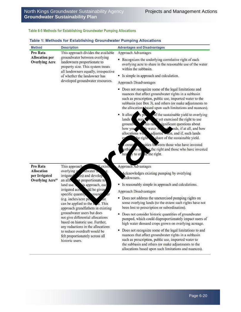
Table 6-5 Methods for Establishing Groundwater Pumping Allocations
Draft

North Kings Groundwater Sustainability Agency Projects and Management Actions Groundwater Sustainability Plan
Page 6-21
There are a myriad of advantages and disadvantages associated with each method of establishing groundwater pumping allocations. The “Comprehensive Allocation Method,” which establishes allocations based on a comprehensive consideration of California groundwater law to the extent practical and is recommended by EDF, as one possible approach that could be considered because it offers NKGSAs the important advantage of presenting to the Court an allocation methodology that tracks judicial precedent if an adjudication is ultimately initiated.
Draft

North Kings Groundwater Sustainability Agency Projects and Management Actions Groundwater Sustainability Plan
Page 6-22
GA-3 Groundwater Allocation “Ramp-Down” Gradual Decrease
Once an individual groundwater allocation is determined, the NKGSA may adopt a policy which provides a gradual “ramp-down” allocation decrease over time to arrive at the actual groundwater allocation to allow stakeholders time to adjust to the concept of an allocation. The policy would detail the number of years and amount of reduction each year. The annual changes in groundwater allocation would be provided in the annual correspondence mailer described in the education and outreach management action above, as well as information presented on the NKGSA website.
GA-4 Groundwater Allocation “Adaptive Management” Approach
The NKGSA may adopt a policy which states an adaptive management approach, whereby the groundwater allocation may be reviewed, changed, and reestablished periodically or during extreme drought as necessary to achieve long term sustainability. It is prudent for the NKGSA to acknowledge the current level of uncertainty in the available data and existing data gaps by providing flexibility in initial groundwater allocations as more data is gathered and analyzed in the upcoming years. Adaptive management is an approach to resource management that “promotes flexible decision making that can be adjusted in the face of uncertainties as outcomes from management actions and other events become better understood. Careful monitoring of these outcomes both advances understanding and helps adjust policies or operations as part of an iterative learning process. Adaptive management also recognizes the importance of natural variability in contributing to ecological resilience and productivity. It is not a ‘trial and error’ process, but rather emphasizes “learning while doing”. There are various advantages, disadvantages, and costs to all of the stated quantification methods noted above. The NKGSA may consider exploring some of these methods with neighboring GSAs and basin wide for an aggregated approach and mutual cost savings.
Management Action No.: GA1 through GA4
Measurable Objective(s) Addressed - 354.44(b)(1) The method of evaluation of groundwater extraction in acre-feet depends upon the NKGSA’s
selected quantification method or combination of methods. The NKGSA evaluation of various methods may consider a wide range of factors including cost, accuracy, reliability, timeliness, functionality, personnel required, and legal defense. Once the NKGSA has established a consistent quantification method, the evaluation of the “ramp-down” gradual allocation decrease could be analyzed in the annual comparison of groundwater extraction. Though the annual groundwater extraction amount would be affected by other factors such as weather and available surface water supplies, the total extraction amount could be normalized to an average water year for comparative purposes. The goals of the groundwater allocation management action would be to ensure a fair groundwater allocation, allow groundwater users time to adjust, provide future flexibility in allocation determinations, and to accurately and efficiently quantify groundwater extractions. The measurable objective is the volume of groundwater extraction in acre-feet GSA wide and on a per acre basis.
Circumstances and Criteria for Implementation - 354.44(b)(1)(A) The selection of groundwater extraction quantification method may be implemented shortly
after the adoption of the GSP for the purposes of the required SMGA annual reporting in coordination with other GSAs in the subbasin. The selected groundwater extraction
Draft

North Kings Groundwater Sustainability Agency Projects and Management Actions Groundwater Sustainability Plan
Page 6-23
Management Action No.: GA1 through GA4
quantification method may change over time. The NKGSA may consider an investigative study to determine the current and future needs of the existing water rights holders, all stakeholder, and unexercised rights to determine the sustainable yield and groundwater allocation.
Process for Public Notification - 354.44(b)(1)(B) All public notification will take place in the form of regular correspondence from the NKGSA,
as well as any supplementary communication between the landowner and the NKGSA or agency as deemed necessary by the Board of Directors.
Permitting and Regulatory Requirements - 354.44(b)(3) The NKGSA is responsible to adhere to state water rights law. No permit or regulatory process
is required for the NKGSA to adopt the groundwater allocation policy. The NKGSA may consider the advantages & disadvantages of the mentioned methods due to differing levels of accuracy and reliability. However, SGMA 10725.4 (c) allows NKGSA to investigate property and extraction facilities, though encroachment permits, or access agreements may be necessary in some locations. This management action does not rely on water from outside the jurisdiction of the NKGSA.
Status and Schedule - 354.44(b)(4) The groundwater extraction quantification method is expected to commence shortly after the
adoption of the GSP and be completed within 3 years. The other actions have not been drafted and are not being considered at this time.
Evaluation of Benefits - 354.44(b)(5) The expected benefits may mitigate overdraft by improving the NKGSA's knowledge of
aggregate and individual groundwater extractions. The development of a groundwater allocation per acre may be based on the NKGSA's current sustainable yield in coordination with other GSAs in the subbasin. The groundwater allocation management action alone may generate a negligible quantifiable demand reduction, but it would benefit Education and Outreach and serve as a prerequisite to other management actions.
How will the management action be accomplished? - 354.44(b)(6) The NKGSA will coordinate with the other GSAs for GA-1 and may adopt necessary policy to
assist in establishing quantification methods for obtaining data for the required SGMA reporting requirements. The NKGSA may consider the option to adopt a “Comprehensive Allocation Method” as detailed in the Groundwater Pumping Allocations under California’s Sustainable Groundwater Management Act (Environmental Defense Fund et. al, 2018) as a possible approach to addressing GA-2.
Estimated Costs - 354.44(b)(8) The method of evaluation of groundwater extraction will be considered with other GSAs in the
subbasin. An estimate of costs is not prepared at this time and requires further evaluation. The other actions are not anticipated for implementation at this time and will be further considered when required.
Draft

North Kings Groundwater Sustainability Agency Projects and Management Actions Groundwater Sustainability Plan
Page 6-24
Fees and Incentives Management Actions
The NKGSA may adopt a management action to levy groundwater fees for agencies or stakeholders that do not mitigate for their estimated groundwater impact. Amounts and specifics have not been defined as these management actions are not required at this time. Implementation of these management actions will require further definition and board approval if the NKGSA decides to implement
Groundwater Pumping Restrictions Management Actions
The NKGSA may consider a groundwater pumping restrictions management action encompassing policies related to the prohibition of new groundwater exports, requiring new developments to prove sustainable water supply, pumping restrictions during droughts, and moratorium on new production wells.
GP-1 Regulate Groundwater Exports
The NKGSA may adopt a policy to prohibit new groundwater exports outside of the NKGSA boundary. The NKGSA may assure performance by enforcing rigid penalties for illegal actions. The NKGSA may approve external exports in limited quantities for emergency situations and levy fees for metering the exported amount.
GP-2 Require New Developments to Prove Sustainable Water Supply
The NKGSA may adopt a policy to require new developments to prove sustainable water supplies. The NKGSA may review and comment on all new development environmental documents to ensure water balance and corresponding mitigation measures are implemented. This policy requires the support and coordination of the member agencies during their typical project permitting process.
GP-3 Pumping Restrictions During Droughts
The NKGSA may adopt a policy to immediately reduce or temporarily suspend groundwater pumping during specific intervals such as extreme drought periods. Immediate restrictions may be the result of minimum threshold exceedances. The NKGSA may consider significant penalties for violators. The NKGSA may consider liens or cease and desist orders for excessive abuse. Municipal agencies within the NKGSA have drought restriction and water conservation programs for drought conditions.
Management Action No.: GP1 through GP3
Measurable Objective(s) Addressed - 354.44(b)(1) GP1: The goal is to ensure all groundwater supplies within the NKGSA are consumed or
retained within the NKGSA boundary. The measurable objective is the metered volume of exported water with the goal of 0.0 acre-feet/year.
GP2: The goal is to ensure all new developments have documented sustainable water supply and groundwater supplies are consumed or retained within the NKGSA boundary. The measurable objective is proven new development water balance with the goal of 0.0 acre-feet groundwater overdraft /year.
Draft

North Kings Groundwater Sustainability Agency Projects and Management Actions Groundwater Sustainability Plan
Page 6-25
Management Action No.: GP1 through GP3
GP3: The goal is to immediately reduce groundwater pumping, in the event of a drought. The measurable objective is the volume of groundwater extraction in acre-feet and number of violators.
Circumstances and Criteria for Implementation - 354.44(b)(1)(A) GP1: Though groundwater exports outside of the NKGSA are not currently a common practice,
the NKGSA understands the changing water market conditions may entice beneficial users to seek financial gains by exporting groundwater. The policy may be implemented shortly after the adoption of the GSP and remain indefinitely. The policy fees and penalties may be reviewed by the NKGSA annually.
GP2: The policy may be implemented shortly after the adoption of the GSP and remain until NKGSA overdraft has ended or indefinitely.
GP3: Circumstances of extreme drought or triggers of minimum threshold exceedances may expedite the policy adoption. The policy would remain until extreme drought conditions ended or minimum thresholds were no longer exceeded.
Process for Public Notification - 354.44(b)(1)(B) The NKGSA will utilize the established methods of correspondence as described in EO-1 and
EO-2 to coordinate directly with the extractor to address necessary actions associated with groundwater pumping restrictions. If deemed necessary the Board of Directors will adopt policy to, address, issue warnings and implement pumping restrictions if the circumstances require it.
Permitting and Regulatory Requirements - 354.44(b)(3) No permit or regulatory process is required for the NKGSA to adopt policies to support the
regulations described in this Management Action. No other environmental or regulatory permits would be required.
Status and Schedule - 354.44(b)(4) The policies have not been drafted. They may commence after 10 years of GSP adoption and
be completed within 5 years.
Evaluation of Benefits - 354.44(b)(5) GP1: The expected benefits may mitigate overdraft by ensuring groundwater supplies are
consumed or retained within the NKGSA boundary. Emergency groundwater exports may be metered and recorded by the NKGSA. The method of evaluation may be reviewing the number of emergency export permits.
GP2: The expected benefits may mitigate overdraft by ensuring new developments utilize groundwater supplies in accordance with current NKGSA groundwater allocations and groundwater supplies are consumed or retained within the NKGSA boundary. The method of evaluation may be quantifying the number of new developments within the NKGSA.
GP3: The expected benefits may mitigate local overdraft and minimum threshold exceedances by reducing or temporarily stopping groundwater extractions in a given area. The method of evaluation may be reviewing the financial impacts of reduced or suspended pumping.
How will the management action be accomplished? - 354.44(b)(6)
Draft

North Kings Groundwater Sustainability Agency Projects and Management Actions Groundwater Sustainability Plan
Page 6-26
Management Action No.: GP1 through GP3
GP1: The NKGSA may adopt a policy to charge a fee for existing groundwater exports and/or prohibit new groundwater exports outside of the NKGSA boundary.
GP2 and GP3: Additionally, the NKGSA will assess groundwater conditions as deemed necessary and may adopt policies to support these actions.
Estimated Costs - 354.44(b)(8) GP1: Estimated $10,000 cost to draft and adopt policy. Future emergency permits would include
fees to cover administrative and monitoring costs.
GP2: Estimated $10,000 cost to draft and adopt policy.
GP3: Estimated $10,000 cost to draft and adopt policy. Once adopted, the levied fees may fund other projects and management actions.
Draft
North Kings Groundwater Sustainability Agency Projects and Management Actions Groundwater Sustainability Plan
Page 6-27
6.4 REFERENCES
Environmental Defense Fund & New Current Water and Land LLC (2018, July). Groundwater Pumping Allocations under California’s Sustainable Groundwater Management Act. Environmental Defense Fund, Mammoth Trading, & Daugherty Water for Food Global Institute (2017). Groundwater Trading as a Tool for Implementing California’s Sustainable Groundwater Management Act. Rosedale-Rio Bravo Water Storage District Sustainable Groundwater Management Act (August 2018). A Menu Approach to the Development of Management Actions.
Draft

North Kings Groundwater Sustainability Agency Groundwater Sustainability Plan
Appendix 6 A
Project Information Forms
Draft

Draft

NKGSA Project Information
Form date: April 19, 2019
June 30, 2019Submitted On
Project Name Bakman Water Meter Project
GSA Party that Project will Bene�t Bakman Water Company
GSA Party Contact Shay Bakman
GSA Party Email [email protected]
Agency Implementing Bakman Water Company
Project DescriptionBakman Water Company is installing water meters on all of its approximately 2,450 service connections in its service area. The project will provide an estimated 20% reduction in usage which is approximately 870 acre-feet per year of bene�t. Bakman has initiated meter installation, however is including in the GSP because the bene�ts of the project are just starting to be observed.
EXPECTED ANNUAL BENEFIT (354.44.b.5)
Acre-feet per year 870
Provide a detailed description of how annual bene�t was quanti�ed. The estimate of 20% conservation is based on recent studies and local case studies from the City of Fresno, Clovis and Kerman that have observed 20-26% reduction in usage from leakage reduction and conservation measures.
LOCATION
Township 13
Range 21
Section 31
Latitude 36.750802
Longitude -119.722604
Description Throughout Bakman Service Area
AFFECTED SUSTAINABILITY INDICATOR (354.44b)
1
Draft

Check all that apply: Chronic lowering of groundwater levels
Seawater Intrusion Land Subsidence
Reduction of groundwater storage
Degraded water quality
Depletions of interconnected surface water
Provide a narrative explanation of how the project addresses each Sustainability Indicator selected.The installation of meters will reduce demand thereby reducing the amount of groundwater pumped, helping slow the decline of groundwater levels and retaining more water in groundwater storage.
Type of Project Increase Supply Demand Reduction
Explain:Meter installation has shown to reduce water demands through leak reduction and volume pricing.
REGULATORY/PERMITTING (354.33.b.3)
Permits
Permitting Agency Permit Type
n/a n/a
Is CEQA Complete? Yes No
If complete, please explain.CEQA has been completed.
PROJECT STATUS Conceptual (no feasibility or study work initiated)
Planning (feasibility study and analysis workinitiated)
Preliminary Design (feasibility study completed)
Ready for Construction/Implementation
SCHEDULE (354.44.b.4)
Construction/Implementation Start Year
2015
Construction/Implementation Finish Year
2025
2
Draft

Timeframe to Accrue Bene�ts From 2025
Timeframe to Accrue Bene�ts To 2055
WATER SUPPLY (354.44.b.6)
If the project relies on surface water, provide an explanation of the source reliability of the water supply for the project.The project does not rely on surface water.
LEGAL AUTHORITY (354.44.b.7)
Describe the Agencies legal authority to implement this project.Bakman is regulated by the CPUC for water service and has the legal authority and mandate to install water meters by 2025.
COST & FUNDING SOURCE (354.44.b.7)
Project Capital $2907000
Describe the funding source or how these costs will be met.Bakman has received a grant from the Department of Water Resources for meter installation.
Project O&M/On-going $12500
Source(s)Bakmans annual operations funds.
3
Draft

NKGSA Project Information
Form date: April 19, 2019
April 30, 2019Submitted On
Project Name Biola Groundwater Recharge Project
GSA Party that Project will Bene�t Biola Community Services District
GSA Party Contact Felipe Perez
GSA Party Email [email protected]
Agency Implementing Same
Project DescriptionConstruct a canal turnout and pipeline to deliver surface water from FID Herndon Canal to an existingstorm drain basin that will be enlarged to hold 30 acre-feet of water.
EXPECTED ANNUAL BENEFIT (354.44.b.5)
Acre-feet per year 150
Provide a detailed description of how annual bene�t was quanti�ed. The basin will be capable of percolating 2.5 a-f/day based on percolation tests. Assuming 60 days peryear for percolation time, the total amount is 150 a-f /yr.
Biola DWR GWR_Pre-Design Rpt.pdf
LOCATION
Township 13
Range 18
Section 16
Latitude 36.800000
Longitude -120.020800
Description South of H Street and East of Howard Avenue in Biola
AFFECTED SUSTAINABILITY INDICATOR (354.44b)
1
Draft

Check all that apply: Chronic lowering of groundwater levels
Seawater Intrusion Land Subsidence
Reduction of groundwater storage
Degraded water quality
Depletions of interconnected surface water
Provide a narrative explanation of how the project addresses each Sustainability Indicator selected.The project will allow the percolation of surface water to replenish groundwater.
Type of Project Increase Supply Demand Reduction
Explain:The project will allow the percolation of surface water to replenish groundwater which leads foincreased supply.
REGULATORY/PERMITTING (354.33.b.3)
Permits
Permitting Agency Permit Type
Fresno Irrigation District Surface water supply agreement& encroachment
County of Fresno Encroachment permit
Is CEQA Complete? Yes No
PROJECT STATUS Conceptual (no feasibility or study work initiated)
Planning (feasibility study and analysis workinitiated)
Preliminary Design (feasibility study completed)
Ready for Construction/Implementation
SCHEDULE (354.44.b.4)
Construction/Implementation Start Year
2019
Construction/Implementation Finish Year
2020
Timeframe to Accrue Bene�ts From 2021
2
Draft

Timeframe to Accrue Benefits To 2071
WATER SUPPLY (354.44.b.6)
If the project relies on surface water, provide an explanation of the source reliability of the water supply for the project.The project will utilize surface water from Fresno Irrigation District for recharge. FID and BiolaCommunity Services District are working on an agreement for water supply.
LEGAL AUTHORITY (354.44.b.7)
Describe the Agencies legal authority to implement this project.the Biola CSD owns and operates the storm water basin that will be used for the recharge project.
COST & FUNDING SOURCE (354.44.b.7)
Project Capital $705,000
Describe the funding source or how these costs will be met.Biola CSD has received a grant from the California Department of Water Resources to design andconstruct the project.
Project O&M/On-going $2,000
Source(s)Operational costs for maintenance of the basin will come from Biola CSD operational funds.
3
Draft

NKGSA Project Information
Form date: April 19, 2019
May 1, 2019Submitted On
Project Name Marion Recharge Basin Improvements
GSA Party that Project will Bene�t City of Clovis
GSA Party Contact Paul Armendariz
GSA Party Email [email protected]
Agency Implementing City of Clovis
Project DescriptionImprove recharge at the Marion Recharge Basins through a variety of measures to increase percolationincluding routine maintenance and capital projects.
EXPECTED ANNUAL BENEFIT (354.44.b.5)
Acre-feet per year 2,500
Provide a detailed description of how annual bene�t was quanti�ed. Quantity is estimated. They City is entertaining the use of a proprietary product and/or installing drywells to increase groundwater percolation.
LOCATION
Township 12
Range 21
Section 32
Latitude 36.847497
Longitude -119.697005
Description Northwest Area of Alluvial and Sunnyside Avenues
AFFECTED SUSTAINABILITY INDICATOR (354.44b)
1
Draft
Check all that apply: Chronic lowering of groundwater levels
Seawater Intrusion Land Subsidence
Reduction of groundwater storage
Degraded water quality
Depletions of interconnected surface water
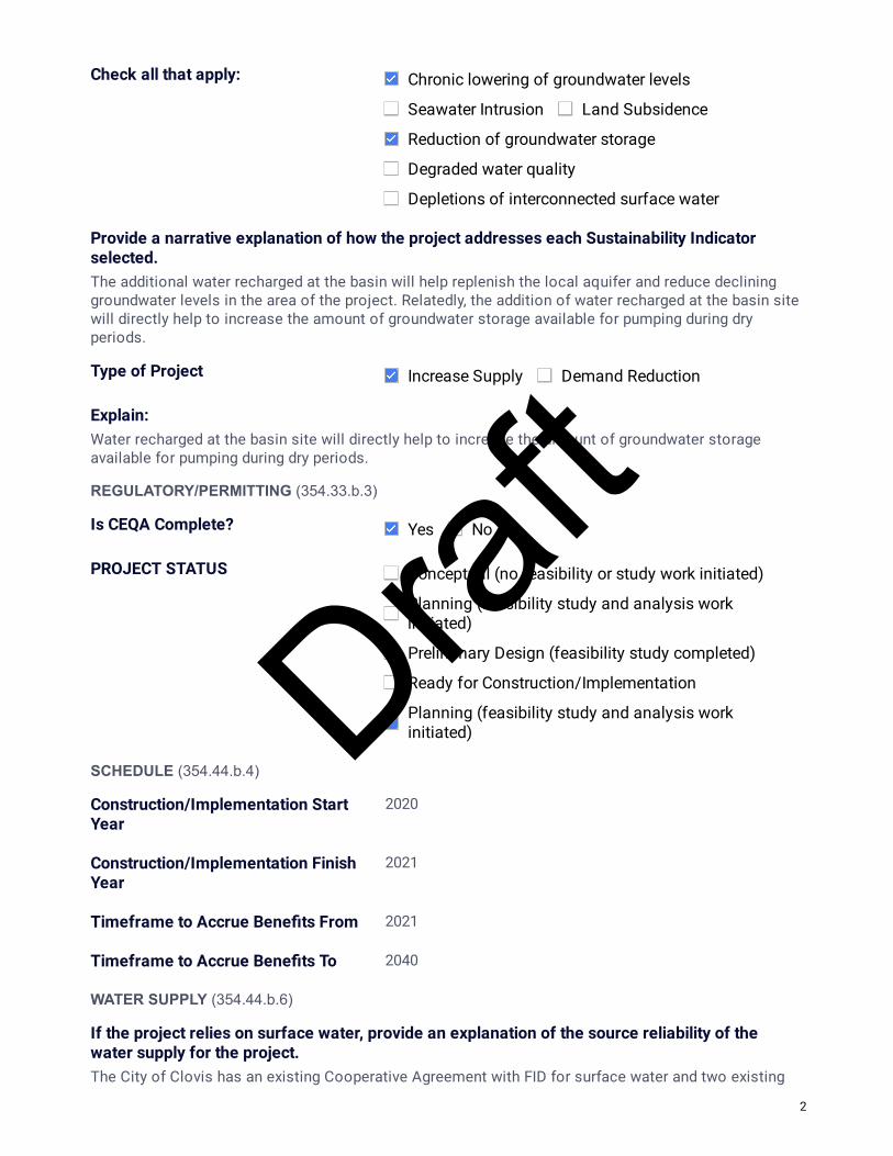
Provide a narrative explanation of how the project addresses each Sustainability Indicator selected.The additional water recharged at the basin will help replenish the local aquifer and reduce declininggroundwater levels in the area of the project. Relatedly, the addition of water recharged at the basin sitewill directly help to increase the amount of groundwater storage available for pumping during dryperiods.
Type of Project Increase Supply Demand Reduction
Explain:Water recharged at the basin site will directly help to increase the amount of groundwater storageavailable for pumping during dry periods.
REGULATORY/PERMITTING (354.33.b.3)
Is CEQA Complete? Yes No
PROJECT STATUS Conceptual (no feasibility or study work initiated)
Planning (feasibility study and analysis workinitiated)
Preliminary Design (feasibility study completed)
Ready for Construction/Implementation
Planning (feasibility study and analysis workinitiated)
SCHEDULE (354.44.b.4)
Construction/Implementation Start Year
2020
Construction/Implementation Finish Year
2021
Timeframe to Accrue Bene�ts From 2021
Timeframe to Accrue Bene�ts To 2040
WATER SUPPLY (354.44.b.6)
If the project relies on surface water, provide an explanation of the source reliability of the water supply for the project.The City of Clovis has an existing Cooperative Agreement with FID for surface water and two existing
2
Draft

Water Banking Agreements. Excess surface water allocation that is not used at the SWTP is diverted tothe Marion Basins for recharge.
LEGAL AUTHORITY (354.44.b.7)
Describe the Agencies legal authority to implement this project.City staff owns and operates the existing recharge basins.
COST & FUNDING SOURCE (354.44.b.7)
Project Capital TBD
Describe the funding source or how these costs will be met.Clovis will fund the project through user enterprise funds and/or will apply for a grant
Project O&M/On-going TBD
Source(s)City staff owns and operates the existing recharge basins.
3
Draft
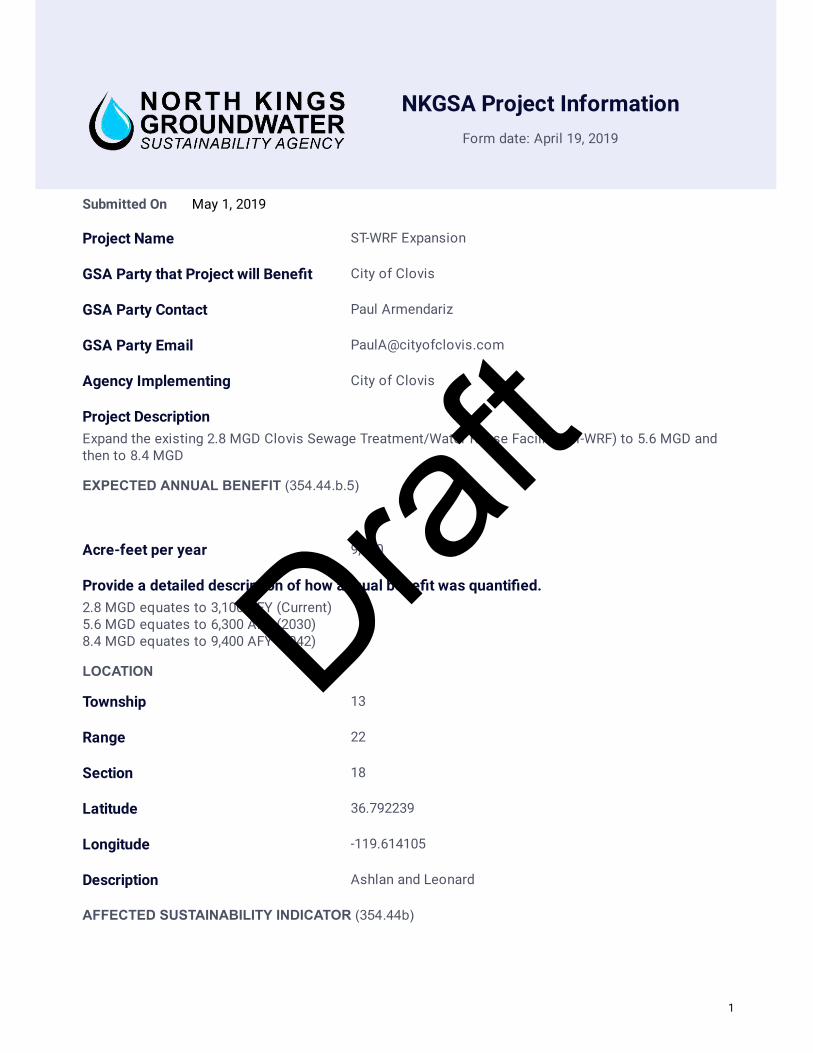
NKGSA Project Information
Form date: April 19, 2019
May 1, 2019Submitted On
Project Name ST-WRF Expansion
GSA Party that Project will Bene�t City of Clovis
GSA Party Contact Paul Armendariz
GSA Party Email [email protected]
Agency Implementing City of Clovis
Project DescriptionExpand the existing 2.8 MGD Clovis Sewage Treatment/Water Reuse Facility (ST-WRF) to 5.6 MGD andthen to 8.4 MGD
EXPECTED ANNUAL BENEFIT (354.44.b.5)
Acre-feet per year 9,400
Provide a detailed description of how annual bene�t was quanti�ed. 2.8 MGD equates to 3,100 AFY (Current) 5.6 MGD equates to 6,300 AFY (2030) 8.4 MGD equates to 9,400 AFY (2042)
LOCATION
Township 13
Range 22
Section 18
Latitude 36.792239
Longitude -119.614105
Description Ashlan and Leonard
AFFECTED SUSTAINABILITY INDICATOR (354.44b)
1
Draft

Check all that apply: Chronic lowering of groundwater levels
Seawater Intrusion Land Subsidence
Reduction of groundwater storage
Degraded water quality
Depletions of interconnected surface water
Provide a narrative explanation of how the project addresses each Sustainability Indicator selected.Use of recycled water (RW) for irrigation replaces the need to irrigate with potable groundwater and/orsurface water. Indirect recharge occurs in landscaped areas. The City also intends to work with theSWRCB on recharge of RW at the Clovis Marion Basins. The additional water recharged at the basin willhelp replenish the local aquifer and reduce declining groundwater levels.
Type of Project Increase Supply Demand Reduction
Explain:Use of recycled water (RW) for irrigation directly offsets the use of potable groundwater and/or surfacewater to irrigate and/or recharge.
REGULATORY/PERMITTING (354.33.b.3)
Permits
Permitting Agency Permit Type
State Water Resources ControlBoard
Water Supply permit and NPDESpermit
Is CEQA Complete? Yes No
If complete, please explain.The expansions were included in the master plan upgrade in 2017 and a SEIR was completed.
PROJECT STATUS Conceptual (no feasibility or study work initiated)
Planning (feasibility study and analysis workinitiated)
Preliminary Design (feasibility study completed)
Ready for Construction/Implementation
Planning (feasibility study and analysis workinitiated)
SCHEDULE (354.44.b.4)
2
Draft

Construction/Implementation Start Year
2030
Construction/Implementation Finish Year
2042
Timeframe to Accrue Bene�ts From 2030
Timeframe to Accrue Bene�ts To 2070
WATER SUPPLY (354.44.b.6)
If the project relies on surface water, provide an explanation of the source reliability of the water supply for the project.This project does not rely on surface water
LEGAL AUTHORITY (354.44.b.7)
Describe the Agencies legal authority to implement this project.The City owns the ST-WRF and currently contracts the operation of the ST-WRF.
COST & FUNDING SOURCE (354.44.b.7)
Project Capital $40.2M
Describe the funding source or how these costs will be met.$20.1M for expansion to 5.6 MGD $20.1M for expansion to 8.4 MGD The City will pay for these projects via Sewer Capital Developer Funds.
Project O&M/On-going $2.5M annually
Source(s)O&M of the existing facility is contracted out and paid for by sewer user enterprise funds. City staff maytake over O&M at the time of the expansion to 5.6MGD
3
Draft

NKGSA Project Information
Form date: April 19, 2019
April 30, 2019Submitted On
Project Name Clovis SWTP Expansion
GSA Party that Project will Bene�t City of Clovis
GSA Party Contact Paul Armendariz
GSA Party Email [email protected]
Agency Implementing City of Clovis
Project DescriptionExpand the existing SWTP 22.5 MGD to a total of 45 MGD.
EXPECTED ANNUAL BENEFIT (354.44.b.5)
Acre-feet per year 25,000
LOCATION
Township 13
Range 21
Section 12
Latitude 36.820052
Longitude -119.639619
Description Leonard south of Bullard
AFFECTED SUSTAINABILITY INDICATOR (354.44b)
Check all that apply: Chronic lowering of groundwater levels
Seawater Intrusion Land Subsidence
Reduction of groundwater storage
Degraded water quality
Depletions of interconnected surface water
1
Draft

Provide a narrative explanation of how the project addresses each Sustainability Indicator selected.The water used through the surface water treatment plant offsets groundwater that is pumped to meetthe City's demands.
Type of Project Increase Supply Demand Reduction
Explain:This project will offset groundwater pumping.
REGULATORY/PERMITTING (354.33.b.3)
Permits
Permitting Agency Permit Type
SWRCB - Division of Drinking Water Supply Permit
Is CEQA Complete? Yes No
If complete, please explain.The project was included in the SEIR completed with the Water Master Plan Update in 2018.
PROJECT STATUS Conceptual (no feasibility or study work initiated)
Planning (feasibility study and analysis workinitiated)
Preliminary Design (feasibility study completed)
Ready for Construction/Implementation
Planning (feasibility study and analysis workinitiated)
SCHEDULE (354.44.b.4)
Construction/Implementation Start Year
2030
Construction/Implementation Finish Year
2031
Timeframe to Accrue Bene�ts From 2031
Timeframe to Accrue Bene�ts To 2070
WATER SUPPLY (354.44.b.6)
If the project relies on surface water, provide an explanation of the source reliability of the
2
Draft

water supply for the project.The City of Clovis has an existing Cooperative Agreement with FID for surface water and two existingWater Banking Agreements. The City is also working with FID on an updated Cooperative agreementand additional water supplies.
LEGAL AUTHORITY (354.44.b.7)
Describe the Agencies legal authority to implement this project.This will be a City owned and operated facility. Surface water delivery will be coordinated with FID.
COST & FUNDING SOURCE (354.44.b.7)
Project Capital $30,000,000
Describe the funding source or how these costs will be met.This project will be funded by Water Capital Developer Funds.
Project O&M/On-going TBD
Source(s)Additional staff will be required to operate the plant expansion.
3
Draft
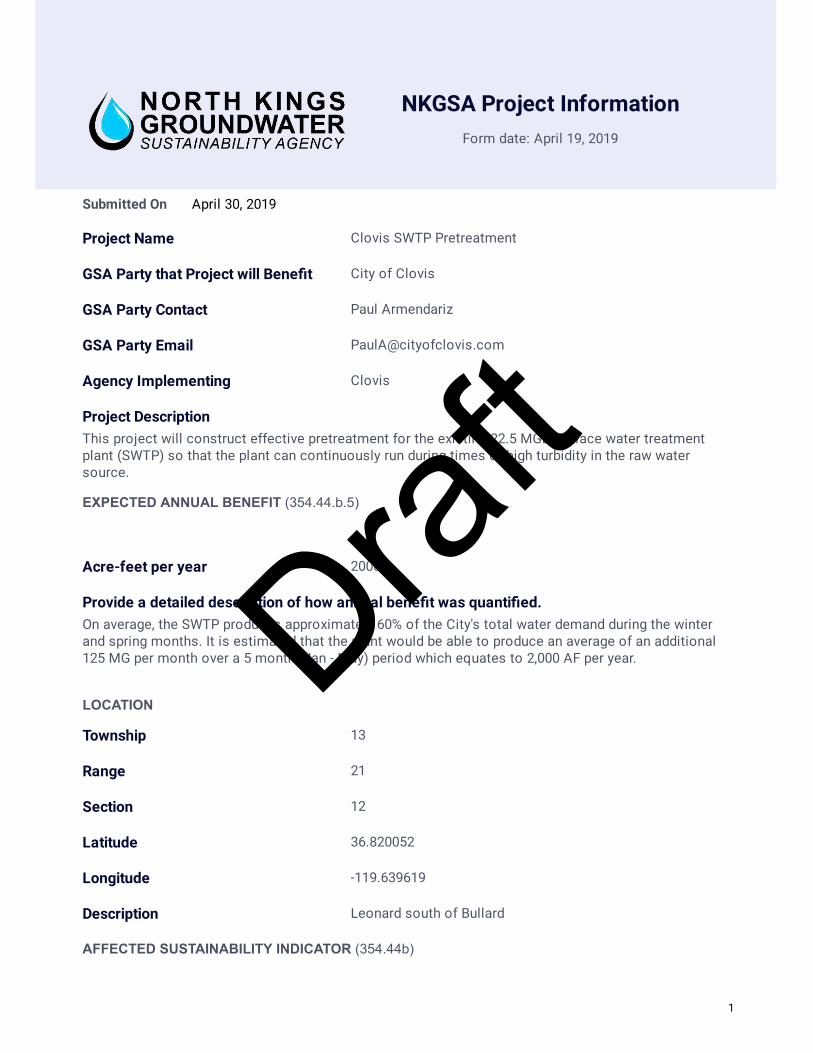
NKGSA Project Information
Form date: April 19, 2019
April 30, 2019Submitted On
Project Name Clovis SWTP Pretreatment
GSA Party that Project will Bene�t City of Clovis
GSA Party Contact Paul Armendariz
GSA Party Email [email protected]
Agency Implementing Clovis
Project DescriptionThis project will construct effective pretreatment for the existing 22.5 MGD surface water treatmentplant (SWTP) so that the plant can continuously run during times of high turbidity in the raw watersource.
EXPECTED ANNUAL BENEFIT (354.44.b.5)
Acre-feet per year 2000
Provide a detailed description of how annual bene�t was quanti�ed. On average, the SWTP produces approximately 60% of the City's total water demand during the winterand spring months. It is estimated that the plant would be able to produce an average of an additional125 MG per month over a 5 month (Jan - May) period which equates to 2,000 AF per year.
LOCATION
Township 13
Range 21
Section 12
Latitude 36.820052
Longitude -119.639619
Description Leonard south of Bullard
AFFECTED SUSTAINABILITY INDICATOR (354.44b)
1
Draft

Check all that apply: Chronic lowering of groundwater levels
Seawater Intrusion Land Subsidence
Reduction of groundwater storage
Degraded water quality
Depletions of interconnected surface water
Provide a narrative explanation of how the project addresses each Sustainability Indicator selected.The water used through the surface water treatment plant offsets groundwater that is pumped to meetthe City's demands.
Type of Project Increase Supply Demand Reduction
Explain:This project will help the City utilize its current surface water allocation and will offset groundwaterpumping.
REGULATORY/PERMITTING (354.33.b.3)
Permits
Permitting Agency Permit Type
SWRCB - Division of DrinkingWater
Water Supply PermitAmendment
Is CEQA Complete? Yes No
PROJECT STATUS Conceptual (no feasibility or study work initiated)
Planning (feasibility study and analysis workinitiated)
Preliminary Design (feasibility study completed)
Ready for Construction/Implementation
Planning (feasibility study and analysis workinitiated)
SCHEDULE (354.44.b.4)
Construction/Implementation Start Year
2020
Construction/Implementation Finish Year
2021
2
Draft

Timeframe to Accrue Benefits From 2021
Timeframe to Accrue Bene�ts To 2040
WATER SUPPLY (354.44.b.6)
If the project relies on surface water, provide an explanation of the source reliability of the water supply for the project.The City of Clovis has an existing Cooperative Agreement with FID for surface water and two existingWater Banking Agreements.
LEGAL AUTHORITY (354.44.b.7)
Describe the Agencies legal authority to implement this project.The City owns and operates the existing 22.5 MGD SWTP.
COST & FUNDING SOURCE (354.44.b.7)
Project Capital $1,025,000
Describe the funding source or how these costs will be met.This project will be funded by Water User Enterprise Funds.
Project O&M/On-going $10,000
Source(s)The annual operational costs are anticipated to be minimal as City staff already operates the existingfacility.
3
Draft
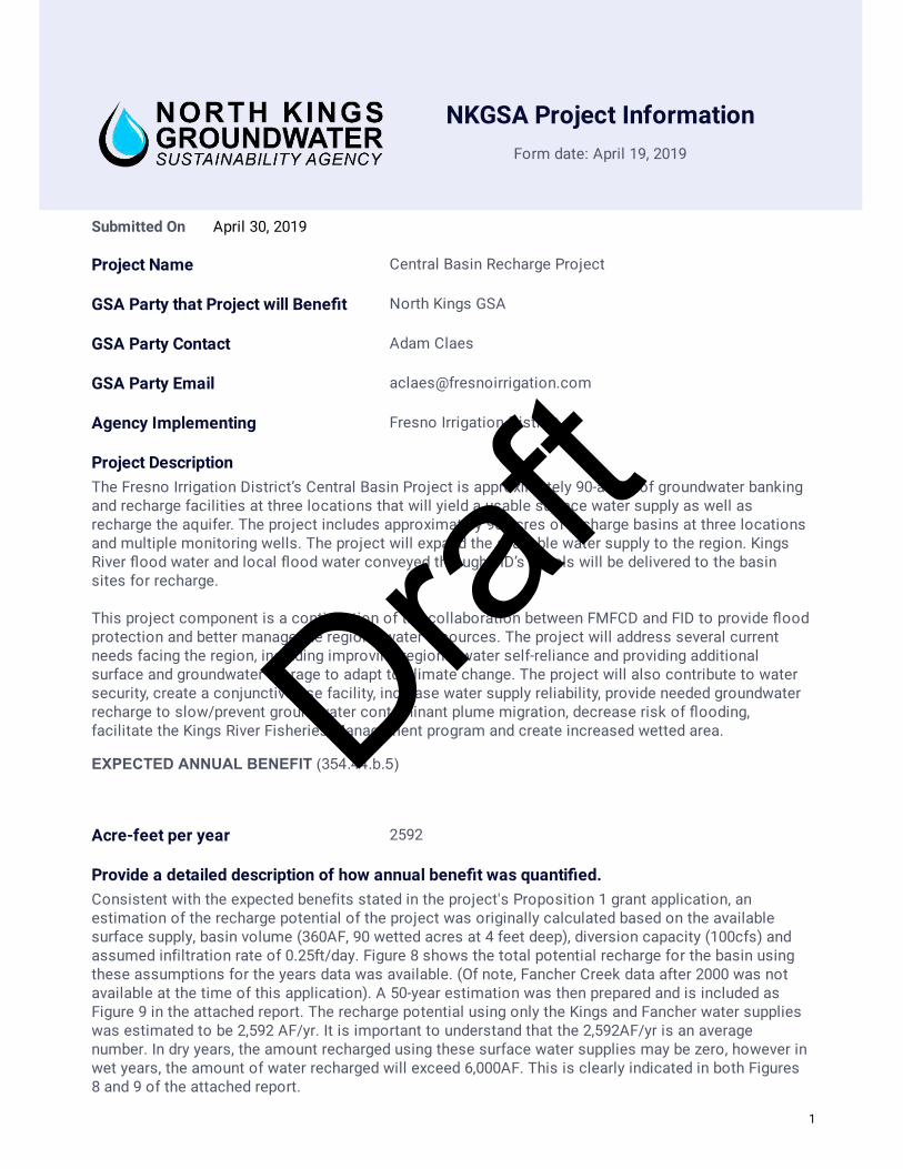
NKGSA Project Information
Form date: April 19, 2019
April 30, 2019Submitted On
Project Name Central Basin Recharge Project
GSA Party that Project will Bene�t North Kings GSA
GSA Party Contact Adam Claes
GSA Party Email [email protected]
Agency Implementing Fresno Irrigation District
Project DescriptionThe Fresno Irrigation District’s Central Basin Project is approximately 90-acres of groundwater bankingand recharge facilities at three locations that will yield a usable surface water supply as well asrecharge the aquifer. The project includes approximately 90-acres of recharge basins at three locationsand multiple monitoring wells. The project will expand the available water supply to the region. KingsRiver �ood water and local �ood water conveyed through FID’s canals will be delivered to the basinsites for recharge. This project component is a continuation of the collaboration between FMFCD and FID to provide �oodprotection and better manage the region’s water resources. The project will address several currentneeds facing the region, including improving regional water self-reliance and providing additionalsurface and groundwater storage to adapt to climate change. The project will also contribute to watersecurity, create a conjunctive use facility, increase water supply reliability, provide needed groundwaterrecharge to slow/prevent groundwater contaminant plume migration, decrease risk of �ooding,facilitate the Kings River Fisheries Management program and create increased wetted area.
EXPECTED ANNUAL BENEFIT (354.44.b.5)
Acre-feet per year 2592
Provide a detailed description of how annual bene�t was quanti�ed. Consistent with the expected benefits stated in the project's Proposition 1 grant application, anestimation of the recharge potential of the project was originally calculated based on the availablesurface supply, basin volume (360AF, 90 wetted acres at 4 feet deep), diversion capacity (100cfs) andassumed infiltration rate of 0.25ft/day. Figure 8 shows the total potential recharge for the basin usingthese assumptions for the years data was available. (Of note, Fancher Creek data after 2000 was notavailable at the time of this application). A 50-year estimation was then prepared and is included asFigure 9 in the attached report. The recharge potential using only the Kings and Fancher water supplieswas estimated to be 2,592 AF/yr. It is important to understand that the 2,592AF/yr is an averagenumber. In dry years, the amount recharged using these surface water supplies may be zero, however inwet years, the amount of water recharged will exceed 6,000AF. This is clearly indicated in both Figures8 and 9 of the attached report.
1
Draft

After the original expected annual benefit was calculated for the Proposition 1 grant application, theproject was later reduced in size from 100 acres to 90 acres. However, using a still conservativerecharge estimate of 0.3 ft/day infiltration rate, the project at three sites is estimated to recharge 2,717AF/yr, which exceeds the originally planned estimate of 2,592 AF/yr. The 2,592 AF/yr will still be usedas a conservative estimate.
Attachment 09 Technical Report Summary.pdf
LOCATION
Township 14
Range 20
Section 31
Latitude 36.676891
Longitude -119.840065
Description Location above is for the Central & Hughes location. Multiplelocations (N/E Lincoln & Orange Ave, S/E East & Malaga Ave,S/W Central & Hughes Ave)
AFFECTED SUSTAINABILITY INDICATOR (354.44b)
Check all that apply: Chronic lowering of groundwater levels
Seawater Intrusion Land Subsidence
Reduction of groundwater storage
Degraded water quality
Depletions of interconnected surface water
Provide a narrative explanation of how the project addresses each Sustainability Indicator selected.The project is a groundwater recharge facility that will replenish the groundwater aquifer using availablesurface water supplies. This project will help bolster groundwater levels as well as add additional waterto the area's groundwater storage.
Type of Project Increase Supply Demand Reduction
Explain:This project will allow additional surface water supplies, that would have otherwise left our region, tostay within the NKGSA and be recharged into the aquifer. This water will increase the amount ofgroundwater supply available for use.
REGULATORY/PERMITTING (354.33.b.3)
Permits
Permitting Agency Permit Type
2
Draft
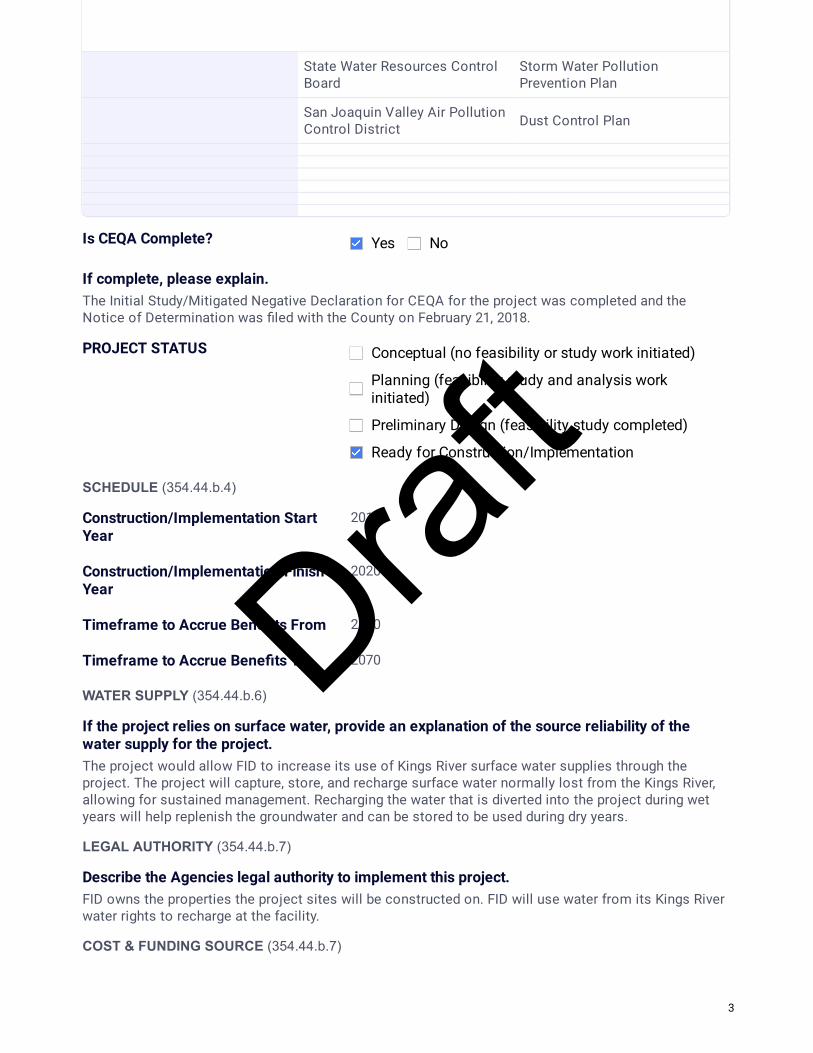
State Water Resources ControlBoard
Storm Water PollutionPrevention Plan
San Joaquin Valley Air PollutionControl District Dust Control Plan
Is CEQA Complete? Yes No
If complete, please explain.The Initial Study/Mitigated Negative Declaration for CEQA for the project was completed and theNotice of Determination was �led with the County on February 21, 2018.
PROJECT STATUS Conceptual (no feasibility or study work initiated)
Planning (feasibility study and analysis workinitiated)
Preliminary Design (feasibility study completed)
Ready for Construction/Implementation
SCHEDULE (354.44.b.4)
Construction/Implementation Start Year
2018
Construction/Implementation Finish Year
2020
Timeframe to Accrue Bene�ts From 2020
Timeframe to Accrue Bene�ts To 2070
WATER SUPPLY (354.44.b.6)
If the project relies on surface water, provide an explanation of the source reliability of the water supply for the project.The project would allow FID to increase its use of Kings River surface water supplies through theproject. The project will capture, store, and recharge surface water normally lost from the Kings River,allowing for sustained management. Recharging the water that is diverted into the project during wetyears will help replenish the groundwater and can be stored to be used during dry years.
LEGAL AUTHORITY (354.44.b.7)
Describe the Agencies legal authority to implement this project.FID owns the properties the project sites will be constructed on. FID will use water from its Kings Riverwater rights to recharge at the facility.
COST & FUNDING SOURCE (354.44.b.7)
3
Draft

Project Capital 6500000
Describe the funding source or how these costs will be met.Through a joint grant application with Fresno Metropolitan Flood Control District with other projects,FID's Central Basin Project was awarded Proposition 1 Stormwater Grant Program grant funding with a30% local match. FID's local match will come from the District's Water Purchase Fund.
Project O&M/On-going $15000
Source(s)The District will operate and maintain the basin sites in accordance with its operation and maintenanceof other facilities using existing staff and FID funds.
4
Draft

NKGSA Project Information
Form date: April 19, 2019
June 30, 2019Submitted On
Project Name Savory Pond Expansion
GSA Party that Project will Bene�t Fresno Irrigation District
GSA Party Contact Adam Claes
GSA Party Email [email protected]
Agency Implementing Fresno Irrigation District
Project DescriptionFID will expand the expanding Savory Pond to an approximately 30-acre recharge basin near the corner of Lincoln & Chestnut Avenues. The project will provide an estimated 1,200AF per year of groundwater recharge to the aquifer. The project will include construction of basin levees, new turnout and �ow measurement into the basin, fencing and other basin improvements.
EXPECTED ANNUAL BENEFIT (354.44.b.5)
Acre-feet per year 1200
Provide a detailed description of how annual bene�t was quanti�ed. The estimated recharge bene�t is based on an assumed in�ltration rate of 0.4 feet per day, for 100 days at the 30 acre basin site. The 0.4 feet per day is considered conservative based on recharge rates at the existing site and other nearby basins. 100 days of delivery of water to the recharge basin is an average annual amount that is also conservative based on available FID surface water supplies.
2019-0402-Proposed Parcel Split Exhibit Final.pdf
LOCATION
Township 15
Range 20
Section 1
Latitude 36.650833
Longitude -119.738314
Description northwest of Lincoln and Chestnut Avenues
1
Draft
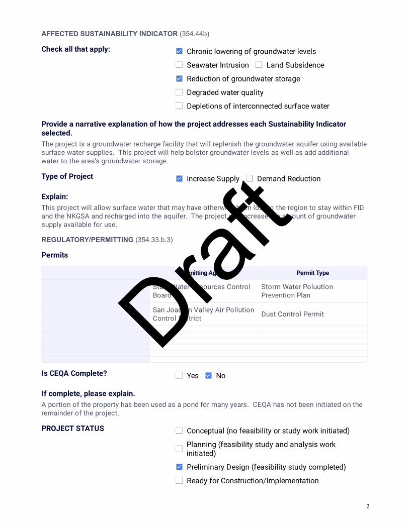
AFFECTED SUSTAINABILITY INDICATOR (354.44b)
Check all that apply: Chronic lowering of groundwater levels
Seawater Intrusion Land Subsidence
Reduction of groundwater storage
Degraded water quality
Depletions of interconnected surface water
Provide a narrative explanation of how the project addresses each Sustainability Indicator selected.The project is a groundwater recharge facility that will replenish the groundwater aquifer using available surface water supplies. This project will help bolster groundwater levels as well as add additional water to the area's groundwater storage.
Type of Project Increase Supply Demand Reduction
Explain:This project will allow surface water that may have otherwise been lost to the region to stay within FID and the NKGSA and recharged into the aquifer. The project will increase the amount of groundwater supply available for use.
REGULATORY/PERMITTING (354.33.b.3)
Permits
Permitting Agency Permit Type
State Water Resources ControlBoard
Storm Water PoluutionPrevention Plan
San Joaquin Valley Air PollutionControl District Dust Control Permit
Is CEQA Complete? Yes No
If complete, please explain.A portion of the property has been used as a pond for many years. CEQA has not been initiated on the remainder of the project.
PROJECT STATUS Conceptual (no feasibility or study work initiated)
Planning (feasibility study and analysis workinitiated)
Preliminary Design (feasibility study completed)
Ready for Construction/Implementation
2
Draft

SCHEDULE (354.44.b.4)
Construction/Implementation Start Year
2020
Construction/Implementation Finish Year
2022
Timeframe to Accrue Bene�ts From 2022
Timeframe to Accrue Bene�ts To 2072
WATER SUPPLY (354.44.b.6)
If the project relies on surface water, provide an explanation of the source reliability of the water supply for the project.The project will utilize FID existing Kings River surface water supplies. In wet years, FID has available surface supply that can be diverted to this basin for recharge. The project will capture, store and recharge surface water that may have otherwise been lost to the region.
LEGAL AUTHORITY (354.44.b.7)
Describe the Agencies legal authority to implement this project.FID owns the property for the project. FID will use water from its existing Kings River water rights.
COST & FUNDING SOURCE (354.44.b.7)
Project Capital $2000000
Describe the funding source or how these costs will be met.Funding will come from FID's Water Purchase Fund to construct the facility.
Project O&M/On-going $10000
Source(s)The District will operate and maintain the basin in accordance with its operation and maintenance of other facilities using existing staff and FID funds.
3
Draft
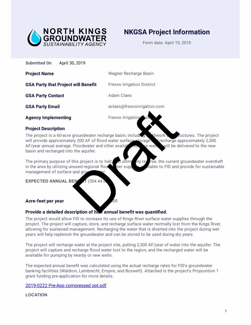
NKGSA Project Information
Form date: April 19, 2019
April 30, 2019Submitted On
Project Name Wagner Recharge Basin
GSA Party that Project will Bene�t Fresno Irrigation District
GSA Party Contact Adam Claes
GSA Party Email [email protected]
Agency Implementing Fresno Irrigation District
Project DescriptionThe project is a 60-acre groundwater recharge basin, including earthwork and structures. The projectwill provide approximately 200 AF of �ood water surface storage and recharge approximately 2,300AF/year annual average. Floodwater and other available surface waters will be delivered to the newbasin and recharged into the aquifer. The primary purpose of this project is to halt, and ultimately reverse, the current groundwater overdraftin the area by utilizing unused regional �ood water supplies available to FID and provide for sustainablemanagement of surface and groundwater.
EXPECTED ANNUAL BENEFIT (354.44.b.5)
Acre-feet per year 2300
Provide a detailed description of how annual bene�t was quanti�ed. The project would allow FID to increase its use of Kings River surface water supplies through theproject. The project will capture, store, and recharge surface water normally lost from the Kings River,allowing for sustained management. Recharging the water that is diverted into the project during wetyears will help replenish the groundwater and can be stored to be used during dry years. The project will recharge water at the project site, putting 2,300 AF/year of water into the aquifer. Theproject will capture and recharge �ood water lost to the region, and the recharged water will beavailable for pumping by nearby or new wells. The expected annual bene�t was calculated using the actual recharge rates for FID's groundwaterbanking facilities (Waldron, Lambrecht, Empire, and Boswell). Attached is the project's Proposition 1grant funding pre-application for more details.
2019-0222 Pre-App compressed opt.pdf
LOCATION
1
Draft

Township 13
Range 19
Section 18
Latitude 36.802994
Longitude -119.948421
Description Southeast Shaw and Westlawn Avenues
AFFECTED SUSTAINABILITY INDICATOR (354.44b)
Check all that apply: Chronic lowering of groundwater levels
Seawater Intrusion Land Subsidence
Reduction of groundwater storage
Degraded water quality
Depletions of interconnected surface water
Provide a narrative explanation of how the project addresses each Sustainability Indicator selected.This project is a groundwater recharge facility that will replenish the groundwater aquifer usingavailable surface water supplies. This project will help bolster groundwater levels as well as addadditional water to the area's groundwater storage.
Type of Project Increase Supply Demand Reduction
Explain:This project will allow additional surface water supplies, that would have otherwise left our region, tostay within the NKGSA and be recharged into the aquifer. This water will increase the amount ofgroundwater supply available for use.
REGULATORY/PERMITTING (354.33.b.3)
Permits
Permitting Agency Permit Type
State Water Resources ControlBoard
Storm Water PollutionPrevention Plan
San Joaquin Valley Air PollutionControl District Dust Control Plan
Is CEQA Complete? Yes No
2
Draft
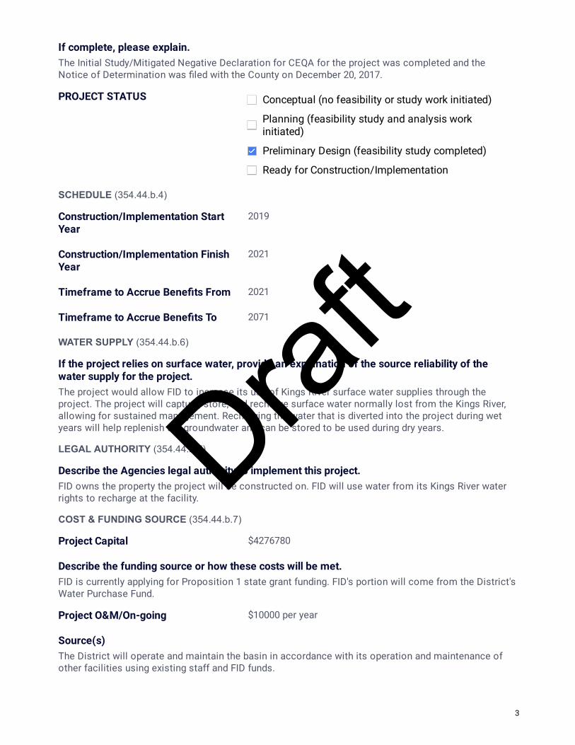
If complete, please explain.The Initial Study/Mitigated Negative Declaration for CEQA for the project was completed and theNotice of Determination was �led with the County on December 20, 2017.
PROJECT STATUS Conceptual (no feasibility or study work initiated)
Planning (feasibility study and analysis workinitiated)
Preliminary Design (feasibility study completed)
Ready for Construction/Implementation
SCHEDULE (354.44.b.4)
Construction/Implementation Start Year
2019
Construction/Implementation Finish Year
2021
Timeframe to Accrue Bene�ts From 2021
Timeframe to Accrue Bene�ts To 2071
WATER SUPPLY (354.44.b.6)
If the project relies on surface water, provide an explanation of the source reliability of the water supply for the project.The project would allow FID to increase its use of Kings River surface water supplies through theproject. The project will capture, store, and recharge surface water normally lost from the Kings River,allowing for sustained management. Recharging the water that is diverted into the project during wetyears will help replenish the groundwater and can be stored to be used during dry years.
LEGAL AUTHORITY (354.44.b.7)
Describe the Agencies legal authority to implement this project.FID owns the property the project will be constructed on. FID will use water from its Kings River waterrights to recharge at the facility.
COST & FUNDING SOURCE (354.44.b.7)
Project Capital $4276780
Describe the funding source or how these costs will be met.FID is currently applying for Proposition 1 state grant funding. FID's portion will come from the District'sWater Purchase Fund.
Project O&M/On-going $10000 per year
Source(s)The District will operate and maintain the basin in accordance with its operation and maintenance ofother facilities using existing staff and FID funds.
3
Draft

NKGSA Project Information
Form date: April 19, 2019
June 30, 2019Submitted On
Project Name FID On-Farm Recharge Program
GSA Party that Project will Bene�t Fresno Irrigation District
GSA Party Contact Adam Claes
GSA Party Email [email protected]
Agency Implementing Fresno Irrigation District
Project DescriptionFID will establish a program to offer and encourage growers to perform on-farm recharge during wet years when �ood release water from the Kings River or CVP Friant system are available for delivery and would otherwise be lost to the region.
EXPECTED ANNUAL BENEFIT (354.44.b.5)
Acre-feet per year 10000
Provide a detailed description of how annual bene�t was quanti�ed. The program is in the conceptual phase and will be dependent on grower's willing to take surface water during wet periods. Floodwater is typically available every 3-4 years. A conservative estimate of 40,000AF of supply could be available for this program, netting an average annual bene�t of 10,000AF if there are willing landowners within the District.
LOCATION
Township 14
Range 19
Section 6
Latitude 36.738848
Longitude -119.943227
Description Throughout the entire District
AFFECTED SUSTAINABILITY INDICATOR (354.44b)
1
Draft
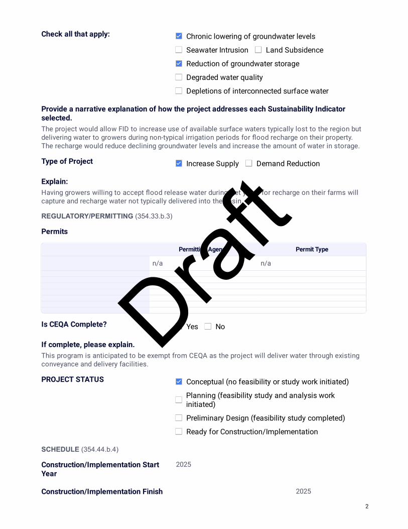
Check all that apply: Chronic lowering of groundwater levels
Seawater Intrusion Land Subsidence
Reduction of groundwater storage
Degraded water quality
Depletions of interconnected surface water
Provide a narrative explanation of how the project addresses each Sustainability Indicator selected.The project would allow FID to increase use of available surface waters typically lost to the region but delivering water to growers during non-typical irrigation periods for �ood recharge on their property. The recharge would reduce declining groundwater levels and increase the amount of water in storage.
Type of Project Increase Supply Demand Reduction
Explain:Having growers willing to accept �ood release water during wet years for recharge on their farms will capture and recharge water not typically delivered into the basin.
REGULATORY/PERMITTING (354.33.b.3)
Permits
Permitting Agency Permit Type
n/a n/a
Is CEQA Complete? Yes No
If complete, please explain.This program is anticipated to be exempt from CEQA as the project will deliver water through existing conveyance and delivery facilities.
PROJECT STATUS Conceptual (no feasibility or study work initiated)
Planning (feasibility study and analysis workinitiated)
Preliminary Design (feasibility study completed)
Ready for Construction/Implementation
SCHEDULE (354.44.b.4)
Construction/Implementation Start Year
2025
Construction/Implementation Finish 2025
2
Draft

Year
Timeframe to Accrue Bene�ts From 2025
Timeframe to Accrue Bene�ts To 2075
WATER SUPPLY (354.44.b.6)
If the project relies on surface water, provide an explanation of the source reliability of the water supply for the project.The project will utilize existing surface water rights that FID has but is unable to utilize in wet years or when storage is limited.
LEGAL AUTHORITY (354.44.b.7)
Describe the Agencies legal authority to implement this project.FID has the water right for the supply considered. FID will not divert water to landowner property without their consent.
COST & FUNDING SOURCE (354.44.b.7)
Project Capital $100000
Describe the funding source or how these costs will be met.A minimal cost of the program is anticipated. A conservative estimate of $100,000 is considered for evaluation of alternatives, communication with growers, study of priority areas, potential effects on crop yields or other considerations needed. No infrastructure is anticipated to be required. FID will fund out of its Water Purchase Fund.
Project O&M/On-going $10000
Source(s)The program may require increased operational sta�ng during winter months. FID will fund ongoing operations through existing operation funds.
3
Draft

NKGSA Project Information
Form date: April 19, 2019
June 12, 2019Submitted On
Project Name Nielsen Recharge Facility
GSA Party that Project will Bene�t City of Fresno
GSA Party Contact Glenn Knapp
GSA Party Email [email protected]
Agency Implementing City of Fresno
Project DescriptionThis project is to expand the City's groundwater recharge program and includes land acquisition, development of new recharge basins, structures and conveyance sytems such as pipelines, canal turn-outs, metering systems, and interties. The project goal is to optimize groundwater recharge efforts so as to balance groundwater extractions as laid out in the City's 2014 Metropolitan Water Resources Plan.
EXPECTED ANNUAL BENEFIT (354.44.b.5)
Acre-feet per year 3,500
Provide a detailed description of how annual bene�t was quanti�ed. The provided value is the measured �ow that was delivered to the facility last year for groundwater recharge purposes.
LOCATION
Township 14
Range 19
Section 1
Latitude 36.7450
Longitude 119.8578
Description southwest Fresno
AFFECTED SUSTAINABILITY INDICATOR (354.44b)
1
Draft

Check all that apply: Chronic lowering of groundwater levels
Seawater Intrusion Land Subsidence
Reduction of groundwater storage
Degraded water quality
Depletions of interconnected surface water
Provide a narrative explanation of how the project addresses each Sustainability Indicator selected.As part of the City's long-term effort to replenish the groundwater aquifer this project applies available surface water supplies to excavated recharge basins so it may percolate into the groundwater system. This is a focused effort to eliminate lowering of the groundwater levels and improve groundwater storage.
Explain:Continued growth within the City's Sphere of In�uence requires proactive measures in acquiring additional groundwater recharge areas, and development of new structures and surface water conveyance systems in eliminating groundwater overdraft conditions. This project aids in ensuring the long-term reliability of the groundwater aquifer.
REGULATORY/PERMITTING (354.33.b.3)
Permits
Permitting Agency Permit Type
City of Fresno - Building & SafetyDivision Grading Plan
City of Fresno - DevelopmentDepartment Conditional Use Permit
San Joaquin Valley Air PollutionControl District Dust Control Plan
Is CEQA Complete? Yes No
If complete, please explain.An IS/MND was prepared for the project and completed 2/11/2011.
PROJECT STATUS Conceptual (no feasibility or study work initiated)
Planning (feasibility study and analysis workinitiated)
Preliminary Design (feasibility study completed)
Ready for Construction/Implementation
SCHEDULE (354.44.b.4)
2
Draft

Construction/Implementation Start Year
8/12/2015
Construction/Implementation Finish Year
2/28/2016
Timeframe to Accrue Bene�ts From 2016
Timeframe to Accrue Bene�ts To 2116
WATER SUPPLY (354.44.b.6)
If the project relies on surface water, provide an explanation of the source reliability of the water supply for the project.The City's contract supply for Kings River water through the Fresno Irrigation District is fairly reliable. In periods of extended or severe droughts water may not be available for recharge purposes. It is anticipated however that recharge operations will be possible for most years
LEGAL AUTHORITY (354.44.b.7)
Describe the Agencies legal authority to implement this project.The City owns the recharge facility property and has a secure contract for water supplies. All applicable legal authorities are in-place for this project.
COST & FUNDING SOURCE (354.44.b.7)
Project Capital $3,657,000
Describe the funding source or how these costs will be met.Water Division & Wastewater Enterprise funds.
Project O&M/On-going $74,000
Source(s)Water Division and Wastewater revenue.
3
Draft

NKGSA Project Information
Form date: April 19, 2019
June 14, 2019Submitted On
Project Name Northeast Surface Water Treatment Facility Expansion
GSA Party that Project will Bene�t City of Fresno
GSA Party Contact Brock Buche
GSA Party Email [email protected]
Agency Implementing City of Fresno
Project DescriptionThe NE-SWTF Expansion Project is part of the City's near-term program to attain and maintain the sustainable use of water resources. This project is for the 30-MDG expansion of the existing surface water treatment facility for a total capability of 60-MGD. To enable water from the expansion to reach further into the City large diameter transmission mains will also be constructed. This project will meet future growth demands and ensure groundwater utilization attains and remains at safe-yield levels.
EXPECTED ANNUAL BENEFIT (354.44.b.5)
Acre-feet per year 30,840
Provide a detailed description of how annual bene�t was quanti�ed. Production yield is based on the plant expansion running 335-days per year at a rate of 30-MDG (this is only for the expansion). Actual production may vary on supply availability and other factors.
LOCATION
Township 12
Range 20
Section 13
Latitude 36.8839
Longitude 119.7387
Description Northeast Fresno
AFFECTED SUSTAINABILITY INDICATOR (354.44b)
1
Draft

Check all that apply: Chronic lowering of groundwater levels
Seawater Intrusion Land Subsidence
Reduction of groundwater storage
Degraded water quality
Depletions of interconnected surface water
Provide a narrative explanation of how the project addresses each Sustainability Indicator selected.The utilization of surface water reduces the City's reliance on groundwater thus less groundwater is pumped which will avoid lowering of groundwater levels. Using surface water also allows groundwater storage to recover.
Explain:The City has contracts with the USBR & FID for surface water supplies. The NESWTF permits the treatment of both sources and will further expand potable water supplies.
REGULATORY/PERMITTING (354.33.b.3)
Permits
Permitting Agency Permit Type
City of Fresno - DevelopmentDepartment Conditional Use Permit
City of Fresno - Building & SafetyDivision Building Permits
City of Fresno - Public Works Tra�c Control Plan
State Water Resources ControlBoard
Storm Water PollutionPrevention Plan
San Joaquin Valley Air PollutionControl Board Dust Control Plan
Is CEQA Complete? Yes No
If complete, please explain.The NESWTF Expansion is included in the Programmatic EIR for the 2014 Metropolitan Water Resources Management Plan, but will require a site speci�c review prior to project commencement. It is anticipated that since this project has been preliminarily evaluated at the programmatic level further review will be carried-out satisfactorily within CEQA guideline requirements.
2
Draft
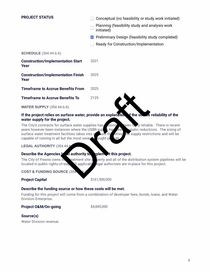
PROJECT STATUS Conceptual (no feasibility or study work initiated)
Planning (feasibility study and analysis workinitiated)
Preliminary Design (feasibility study completed)
Ready for Construction/Implementation
SCHEDULE (354.44.b.4)
Construction/Implementation Start Year
2021
Construction/Implementation Finish Year
2025
Timeframe to Accrue Bene�ts From 2025
Timeframe to Accrue Bene�ts To 2125
WATER SUPPLY (354.44.b.6)
If the project relies on surface water, provide an explanation of the source reliability of the water supply for the project.The City's contracts for surface water supplies has historically been fairly reliable. There in recent years however been instances where the USBR supply has seen dramatic reductions. The sizing of surface water treatment facilities takes into account the infrequent supply restrictions and will be capable of running in all but the most severe-drought periods.
LEGAL AUTHORITY (354.44.b.7)
Describe the Agencies legal authority to implement this project.The City of Fresno owns the treatment site property and all of the distribution system pipelines will be located in public rights-of-way. All applicable legal authorizes are in-place for this project.
COST & FUNDING SOURCE (354.44.b.7)
Project Capital $161,500,000
Describe the funding source or how these costs will be met.Funding for this project will come from a combination of developer fees, bonds, loans, and Water Division Enterprise.
Project O&M/On-going $4,845,000
Source(s)Water Division revenue.
3
Draft

NKGSA Project Information
Form date: April 19, 2019
June 13, 2019Submitted On
Project Name Residential Water Meter Retro�t Project
GSA Party that Project will Bene�t City of Fresno
GSA Party Contact Brock Buche
GSA Party Email [email protected]
Agency Implementing City of Fresno
Project DescriptionIn 2004, California passed State Assembly Bill 514, which requires "urban water suppliers" who receive water from the federal CVP through existing USBR water service contracts, install water meters on all residential service connections on or before January 1, 2013. The City maintains a contract for 60,000 acre feet of surface water every year from the CVP through the USBR. To comply with this bill and to take acts to reduce water consumption all residential services will be equipped with meters.
EXPECTED ANNUAL BENEFIT (354.44.b.5)
Acre-feet per year 43,600
Provide a detailed description of how annual bene�t was quanti�ed. Residential meter installation contracts commenced in 2010 and run through the end of 2012. Per capita water consumption from 2007 through 2011 averaged 277 gpcd. Per capita consumption after meters were installed, excluding the drought period of 2012-2016, averages 201 gpcd (2017 & 2018). The population at the end of 2011 was 513,358. Applying the per capita water consumption values from before and after meter installation yields a 43,600 AF reduction for the base 2011 population.
LOCATION
Township 14
Range 20
Section 3
Latitude 36.7397
Longitude 119.7845
1
Draft

Description Citywide
AFFECTED SUSTAINABILITY INDICATOR (354.44b)
Check all that apply: Chronic lowering of groundwater levels
Seawater Intrusion Land Subsidence
Reduction of groundwater storage
Degraded water quality
Depletions of interconnected surface water
Provide a narrative explanation of how the project addresses each Sustainability Indicator selected.Implementation of volumetric billing incentives conservation and reduces water consumption. The reduced consumption is directly correlated to reduced groundwater pumping and avoidance of lowering groundwater levels. Additionally, reduced reliance on groundwater permits for the recovery of groundwater storage.
Explain:The implementation of volumetric billing enables consumers to acknowledge their use of commodities and incentives conservation. Prior to the installation of water meters average per capita water use in the City was approximately 277 gpcd for the period of 2007 to 2011, and historically had been as high as 324 gpcd in 2001. After meters were installed on all residential services with completion of the project at the end of 2012, it was the �rst time consumers had the opportunity to understand their water use behaviors. Present day per capita use for 2017 & 2018 is now at 201 gpcd. This project had a signi�cant bene�cial impact with demand reduction.
REGULATORY/PERMITTING (354.33.b.3)
Permits
Permitting Agency Permit Type
N/A N/A
Is CEQA Complete? Yes No
If complete, please explain.As part of the Residential Water Meter Retro�t Project an environmental assessment was completed and a Negative Declaration was adopted. A Notice of Determination was then �led with the Fresno County Clerk's O�ce.
2
Draft
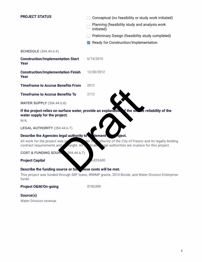
PROJECT STATUS Conceptual (no feasibility or study work initiated)
Planning (feasibility study and analysis workinitiated)
Preliminary Design (feasibility study completed)
Ready for Construction/Implementation
SCHEDULE (354.44.b.4)
Construction/Implementation Start Year
6/15/2010
Construction/Implementation Finish Year
12/30/2012
Timeframe to Accrue Bene�ts From 2012
Timeframe to Accrue Bene�ts To 2112
WATER SUPPLY (354.44.b.6)
If the project relies on surface water, provide an explanation of the source reliability of the water supply for the project.N/A.
LEGAL AUTHORITY (354.44.b.7)
Describe the Agencies legal authority to implement this project.All work for the project was performed under the authority of the City of Fresno and its legally binding contract requirements and oversight. All applicable legal authorities are in-place for this project.
COST & FUNDING SOURCE (354.44.b.7)
Project Capital $76,829,600
Describe the funding source or how these costs will be met.This project was funded through SRF loans, IRWMP grants, 2010 Bonds, and Water Division Enterprise funds.
Project O&M/On-going $150,000
Source(s)Water Division revenue.
3
Draft

NKGSA Project Information
Form date: April 19, 2019
June 14, 2019Submitted On
Project Name Southeast Reclamation Facility and Distribution System
GSA Party that Project will Bene�t City of Fresno
GSA Party Contact Brock Buche
GSA Party Email [email protected]
Agency Implementing City of Fresno
Project DescriptionAs part of the City's long-term goal to utilize resources sustainably the development of a recycled water program will be key. This project includes design and construction of an initial 8-MGD tertiary treatment facility with transmission and distribution mains. The reclaimed water produced and distributed in the southeast region will provide a direct potable water offset, thus reducing the reliance on and use of groundwater supplies.
EXPECTED ANNUAL BENEFIT (354.44.b.5)
Acre-feet per year 4,420
Provide a detailed description of how annual bene�t was quanti�ed. Production yield is based on the tertiary treatment facility operating 335-days per year at a rate of 8-MGD.
LOCATION
Township 13
Range 21
Section 29
Latitude 36.7772
Longitude 119.7009
Description Southeast Fresno
AFFECTED SUSTAINABILITY INDICATOR (354.44b)
1
Draft
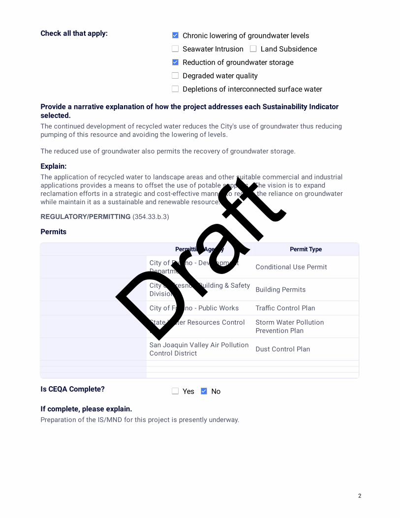
Check all that apply: Chronic lowering of groundwater levels
Seawater Intrusion Land Subsidence
Reduction of groundwater storage
Degraded water quality
Depletions of interconnected surface water
Provide a narrative explanation of how the project addresses each Sustainability Indicator selected.The continued development of recycled water reduces the City's use of groundwater thus reducing pumping of this resource and avoiding the lowering of levels. The reduced use of groundwater also permits the recovery of groundwater storage.
Explain:The application of recycled water to landscape areas and other suitable commercial and industrial applications provides a means to offset the use of potable supplies. The vision is to expand reclamation efforts in a strategic and cost-effective manner to reduce the reliance on groundwater while maintain it as a sustainable and renewable resource.
REGULATORY/PERMITTING (354.33.b.3)
Permits
Permitting Agency Permit Type
City of Fresno - DevelopmentDepartment Conditional Use Permit
City of Fresno - Building & SafetyDivision Building Permits
City of Fresno - Public Works Tra�c Control Plan
State Water Resources ControlBoard
Storm Water PollutionPrevention Plan
San Joaquin Valley Air PollutionControl District Dust Control Plan
Is CEQA Complete? Yes No
If complete, please explain.Preparation of the IS/MND for this project is presently underway.
2
Draft

PROJECT STATUS Conceptual (no feasibility or study work initiated)
Planning (feasibility study and analysis workinitiated)
Preliminary Design (feasibility study completed)
Ready for Construction/Implementation
SCHEDULE (354.44.b.4)
Construction/Implementation Start Year
1/15/2021
Construction/Implementation Finish Year
1/15/2025
Timeframe to Accrue Bene�ts From 2025
Timeframe to Accrue Bene�ts To 2125
WATER SUPPLY (354.44.b.6)
If the project relies on surface water, provide an explanation of the source reliability of the water supply for the project.N/A.
LEGAL AUTHORITY (354.44.b.7)
Describe the Agencies legal authority to implement this project.The City of Fresno owns the treatment site property and all of the distribution system will be located in the public rights-of-way. All applicable legal authorities are in-place for this project.
COST & FUNDING SOURCE (354.44.b.7)
Project Capital $155,000,000
Describe the funding source or how these costs will be met.Project funding will be a combination of development fees, bonds, loans, and enterprise funds.
Project O&M/On-going $4,650,000
Source(s)Wastewater Division revenue.
3
Draft

NKGSA Project Information
Form date: April 19, 2019
June 11, 2019Submitted On
Project Name Southeast Surface Water Treatment Facility
GSA Party that Project will Bene�t City of Fresno
GSA Party Contact Glenn Knapp
GSA Party Email [email protected]
Agency Implementing City of Fresno
Project DescriptionDesign, construction, start-up, and commissioning of the new Southeast Surface Water Treatment Facility (SESWTF) and associated large diameter transmission mains. New facility is required to treat surface water diverted from the Kings River through canal and raw water pipeline system. Historically, the City has largely relied on groundwater to meet municipal water demands. The SESWTF will utilize surface water supplies and permit the balanced use of both groundwater and surface water, thus greatly reducing groundwater extractions.
EXPECTED ANNUAL BENEFIT (354.44.b.5)
Acre-feet per year 82,240
Provide a detailed description of how annual bene�t was quanti�ed. Production yield is based on the plant running 335-days per year at a rate of 80-MGD. Actual production may vary depending on supply availability and other factors.
LOCATION
Township 13
Range 21
Section 34
Latitude 36.7594
Longitude 119.6764
Description SE Fresno
AFFECTED SUSTAINABILITY INDICATOR (354.44b)
1
Draft

Check all that apply: Chronic lowering of groundwater levels
Seawater Intrusion Land Subsidence
Reduction of groundwater storage
Degraded water quality
Depletions of interconnected surface water
Provide a narrative explanation of how the project addresses each Sustainability Indicator selected.The utilization of surface water reduces the City's reliance on groundwater thus less groundwater is pumped which will avoid lowering of groundwater levels. Using surface water also allows groundwater storage to recover.
Explain:The City has contracts with the USBR & FID for surface water supplies but has not been able to fully utilize them. The SESWTF permits the treatment of the Kings River resource to expand potable water supplies.
REGULATORY/PERMITTING (354.33.b.3)
Permits
Permitting Agency Permit Type
City of Frenso - Building & SafetyDivision Building Permits
City of Fresno - Public Works Tra�c Control Plan
County of Fresno - Public Works Tra�c Control Plan
State Water Resources ControlBoard
Storm Water PollutionPrevention Plan
San Joaquin Valley Air PollutionControl District Dust Control Plan
Is CEQA Complete? Yes No
If complete, please explain.The City prepared an update to its Metropolitan Water Resources Management Plan which included the SESWTF in the associated Plan EIR. CEQA has been completed for this project.
PROJECT STATUS Conceptual (no feasibility or study work initiated)
Planning (feasibility study and analysis workinitiated)
Preliminary Design (feasibility study completed)
Ready for Construction/Implementation
2
Draft

SCHEDULE (354.44.b.4)
Construction/Implementation Start Year
12/31/2015
Construction/Implementation Finish Year
9/28/2018
Timeframe to Accrue Bene�ts From 2018
Timeframe to Accrue Bene�ts To 2118
WATER SUPPLY (354.44.b.6)
If the project relies on surface water, provide an explanation of the source reliability of the water supply for the project.The City's contract supply for Kings River water through Fresno Irrigation District is fairly reliable. The allocation each year is based on hydrologic conditions. It is anticipated that in dry years water otherwise used for groundwater recharge will be diverted to the SESWTF for treatment.
LEGAL AUTHORITY (354.44.b.7)
Describe the Agencies legal authority to implement this project.The City owns the treatment site property and has a secure contract for water supplies. All applicable legal authorizes are in-place for this project.
COST & FUNDING SOURCE (354.44.b.7)
Project Capital $314,600,000
Describe the funding source or how these costs will be met.Signi�cant project funding is in the form of SRF low interest loans.
Project O&M/On-going $4,500,000
Source(s)Water Division revenue.
3
Draft

NKGSA Project Information
Form date: April 19, 2019
June 14, 2019Submitted On
Project Name Southwest Reclamation Facility and Distribution System
GSA Party that Project will Bene�t City of Fresno
GSA Party Contact Brock Buche
GSA Party Email [email protected]
Agency Implementing City of Fresno
Project DescriptionAs part of the City's long-term goal to utilize resources sustainably the development of a recycled water program will be key. This project includes the design and construction of an initial 5-MGD tertiary treatment facility and transmission and distribution system. The reclaimed water produced and distributed in the southwest region will provide a direct potable water offset, thus reducing the reliance on and use of groundwater supplies.
EXPECTED ANNUAL BENEFIT (354.44.b.5)
Acre-feet per year 5,140
Provide a detailed description of how annual bene�t was quanti�ed. Production yield is based on the tertiary treatment facility operating 335-days per year at a rate of 5-MGD.
LOCATION
Township 14
Range 19
Section 21
Latitude 36.7049
Longitude 119.9085
Description Southwest Fresno
AFFECTED SUSTAINABILITY INDICATOR (354.44b)
1
Draft

Check all that apply: Chronic lowering of groundwater levels
Seawater Intrusion Land Subsidence
Reduction of groundwater storage
Degraded water quality
Depletions of interconnected surface water
Provide a narrative explanation of how the project addresses each Sustainability Indicator selected.The development of reclamation water reduces the City's use of groundwater thus reduces pumping of this resource and avoiding the lowering of levels. The reduced use of groundwater also permits the recovery of groundwater storage.
Explain:The application of recycled water to landscape areas and other suitable commercial and industrial applications provides a means to offset the use of potable supplies for higher bene�cial uses. The vision is to expand reclamation efforts in a strategic and cost-effective manner to reduce the reliance on groundwater while maintaining it as a sustainable and renewable resource.
REGULATORY/PERMITTING (354.33.b.3)
Permits
Permitting Agency Permit Type
City of Fresno - DevelopmentDepartment Conditional Use Permit
City of Fresno - Building & SafetyDivision Building Permits
City of Fresno - Public Works Tra�c Control Plan
County of Fresno - Public Works Tra�c Control Plan
State Water Resources ControlBoard
Storm Water PollutionPrevention Plan
San Joaquin Valley Air PollutionControl District Dust Control Plan
Is CEQA Complete? Yes No
If complete, please explain.An initial study and Mitigated Negative Declaration was prepared and adopted for the project.
2
Draft

PROJECT STATUS Conceptual (no feasibility or study work initiated)
Planning (feasibility study and analysis workinitiated)
Preliminary Design (feasibility study completed)
Ready for Construction/Implementation
SCHEDULE (354.44.b.4)
Construction/Implementation Start Year
12/14/2014
Construction/Implementation Finish Year
11/29/2019
Timeframe to Accrue Bene�ts From 2019
Timeframe to Accrue Bene�ts To 2119
WATER SUPPLY (354.44.b.6)
If the project relies on surface water, provide an explanation of the source reliability of the water supply for the project.N/A.
LEGAL AUTHORITY (354.44.b.7)
Describe the Agencies legal authority to implement this project.The City of Fresno owns the treatment site property and all of the distribution system will be located in the public right-of-way. All applicable legal authorities are in-place for this project.
COST & FUNDING SOURCE (354.44.b.7)
Project Capital $114,600,000
Describe the funding source or how these costs will be met.Funding sources include bonds, SRF loans, and Wastewater Enterprise funds.
Project O&M/On-going $3,438,000
Source(s)Wastewater Division revenue.
3
Draft
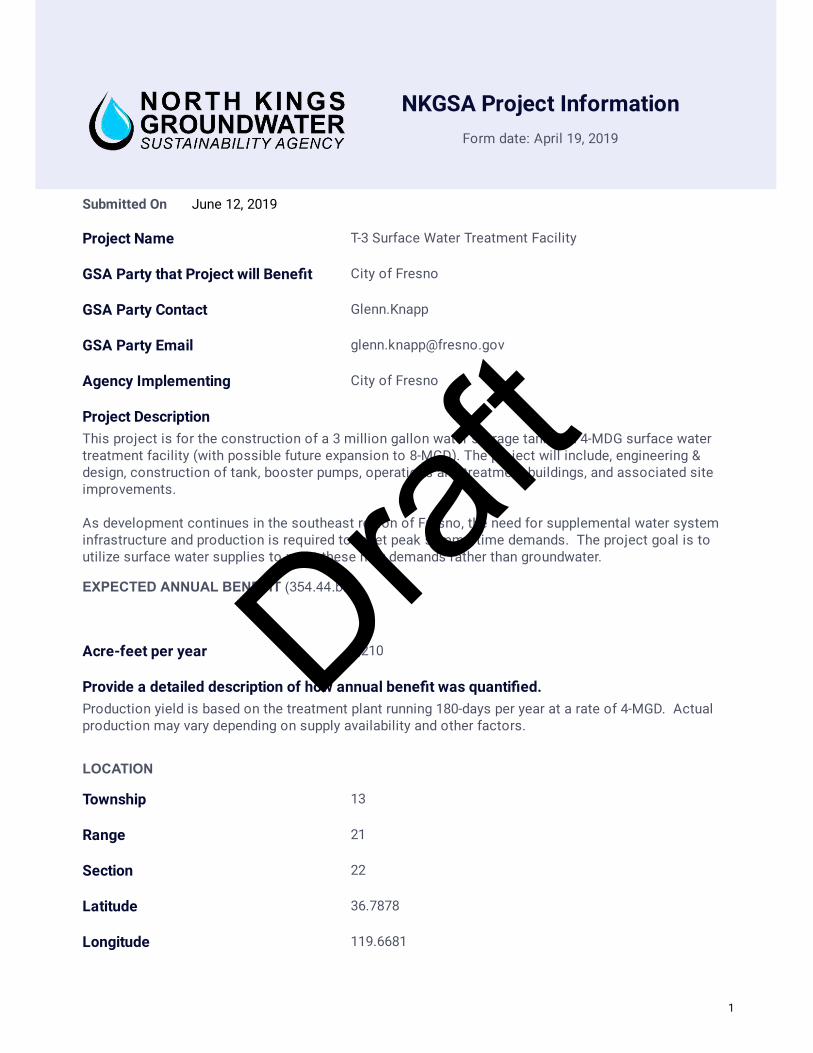
NKGSA Project Information
Form date: April 19, 2019
June 12, 2019Submitted On
Project Name T-3 Surface Water Treatment Facility
GSA Party that Project will Bene�t City of Fresno
GSA Party Contact Glenn.Knapp
GSA Party Email [email protected]
Agency Implementing City of Fresno
Project DescriptionThis project is for the construction of a 3 million gallon water storage tank and 4-MDG surface water treatment facility (with possible future expansion to 8-MGD). The project will include, engineering & design, construction of tank, booster pumps, operations and treatment buildings, and associated site improvements. As development continues in the southeast region of Fresno, the need for supplemental water system infrastructure and production is required to meet peak summertime demands. The project goal is to utilize surface water supplies to meet these new demands rather than groundwater.
EXPECTED ANNUAL BENEFIT (354.44.b.5)
Acre-feet per year 2,210
Provide a detailed description of how annual bene�t was quanti�ed. Production yield is based on the treatment plant running 180-days per year at a rate of 4-MGD. Actual production may vary depending on supply availability and other factors.
LOCATION
Township 13
Range 21
Section 22
Latitude 36.7878
Longitude 119.6681
1
Draft

Description Southeast Fresno
AFFECTED SUSTAINABILITY INDICATOR (354.44b)
Check all that apply: Chronic lowering of groundwater levels
Seawater Intrusion Land Subsidence
Reduction of groundwater storage
Degraded water quality
Depletions of interconnected surface water
Provide a narrative explanation of how the project addresses each Sustainability Indicator selected.The utilization of surface water reduces the City's reliance on groundwater thus less groundwater is pumped and the lowering of levels avoided. Using surface water also allows groundwater storage to recover.
Explain:The City has contracts with the USBR & FID for surface water supplies but has not been able to fully utilize them. The T-3 facility permits the treatment of surface water to expand potable water supplies.
REGULATORY/PERMITTING (354.33.b.3)
Permits
Permitting Agency Permit Type
City of Fresno - DevelopmentDepartment Conditional Use Permit
City of Fresno - Building & SafetyDivision Building Permits
City of Fresno - Public Works Tra�c Control Plan
County of Fresno - Public Works Tra�c Control Plan
State Water Resources ControlBoard
Storm Water PollutionPrevention Plan
San Joaquin Valley Air PollutionControl District Dust Control Plan
Is CEQA Complete? Yes No
If complete, please explain.An IS/MND was prepared and adopted for this project; E C09-158, completed10/16/2009.
2
Draft

PROJECT STATUS Conceptual (no feasibility or study work initiated)
Planning (feasibility study and analysis workinitiated)
Preliminary Design (feasibility study completed)
Ready for Construction/Implementation
SCHEDULE (354.44.b.4)
Construction/Implementation Start Year
2/21/2011
Construction/Implementation Finish Year
11/21/2013
Timeframe to Accrue Bene�ts From 2013
Timeframe to Accrue Bene�ts To 2163
WATER SUPPLY (354.44.b.6)
If the project relies on surface water, provide an explanation of the source reliability of the water supply for the project.The City's contract supply of Kings River water through the Fresno Irrigation District is fairly reliable. The allocation each year is based on hydrologic conditions. It is anticipated water otherwise used for recharge will be directed to the T-3 facility in dry years for treatment.
LEGAL AUTHORITY (354.44.b.7)
Describe the Agencies legal authority to implement this project.The City of Fresno owns the treatment site property and has a secure contract for water supplies. All applicable legal authorities are in-place for this project.
COST & FUNDING SOURCE (354.44.b.7)
Project Capital $21,819,800
Describe the funding source or how these costs will be met.Water Division enterprise funds and 2010 bond funds.
Project O&M/On-going $500,000
Source(s)Water Division revenue.
3
Draft
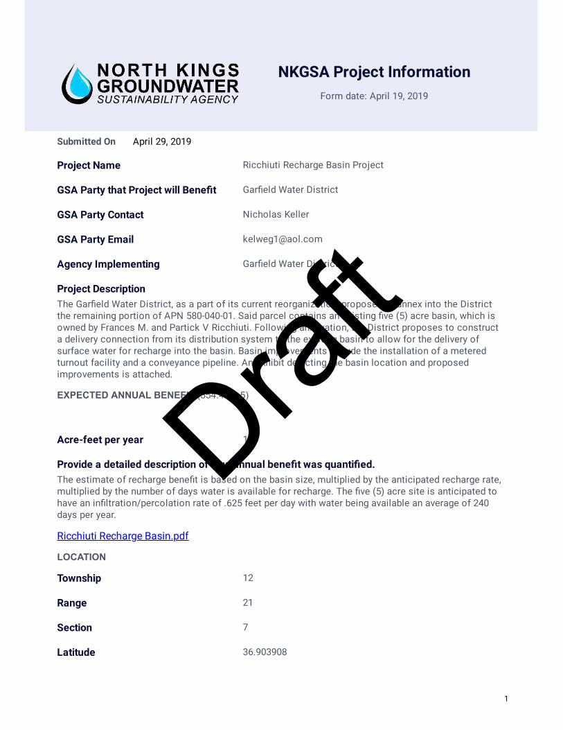
NKGSA Project Information
Form date: April 19, 2019
April 29, 2019Submitted On
Project Name Ricchiuti Recharge Basin Project
GSA Party that Project will Bene�t Gar�eld Water District
GSA Party Contact Nicholas Keller
GSA Party Email [email protected]
Agency Implementing Gar�eld Water District
Project DescriptionThe Gar�eld Water District, as a part of its current reorganization, proposes to annex into the Districtthe remaining portion of APN 580-040-01. Said parcel contains an existing �ve (5) acre basin, which isowned by Frances M. and Partick V Ricchiuti. Following annexation, the District proposes to constructa delivery connection from its distribution system to the existing basin to allow for the delivery ofsurface water for recharge into the basin. Basin improvements include the installation of a meteredturnout facility and a conveyance pipeline. An exhibit depicting the basin location and proposedimprovements is attached.
EXPECTED ANNUAL BENEFIT (354.44.b.5)
Acre-feet per year 150
Provide a detailed description of how annual bene�t was quanti�ed. The estimate of recharge bene�t is based on the basin size, multiplied by the anticipated recharge rate,multiplied by the number of days water is available for recharge. The �ve (5) acre site is anticipated tohave an in�ltration/percolation rate of .625 feet per day with water being available an average of 240days per year.
Ricchiuti Recharge Basin.pdf
LOCATION
Township 12
Range 21
Section 7
Latitude 36.903908
1
Draft
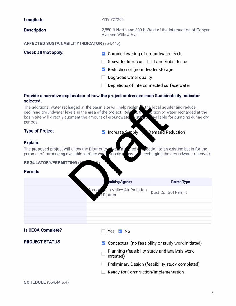
Longitude -119.727265
Description 2,850 ft North and 800 ft West of the intersection of CopperAve and Willow Ave
AFFECTED SUSTAINABILITY INDICATOR (354.44b)
Check all that apply: Chronic lowering of groundwater levels
Seawater Intrusion Land Subsidence
Reduction of groundwater storage
Degraded water quality
Depletions of interconnected surface water
Provide a narrative explanation of how the project addresses each Sustainability Indicator selected.The additional water recharged at the basin site will help replenish the local aquifer and reducedeclining groundwater levels in the area of the project. Related, the addition of water recharged at thebasin site will directly augment the amount of groundwater in storage available for pumping during dryperiods.
Type of Project Increase Supply Demand Reduction
Explain:The proposed project will allow the District to have a metered connection to an existing basin for thepurpose of introducing available surface water supply to assist in recharging the groundwater reservoir.
REGULATORY/PERMITTING (354.33.b.3)
Permits
Permitting Agency Permit Type
San Joaquin Valley Air PollutionControl District Dust Control Permit
Is CEQA Complete? Yes No
PROJECT STATUS Conceptual (no feasibility or study work initiated)
Planning (feasibility study and analysis workinitiated)
Preliminary Design (feasibility study completed)
Ready for Construction/Implementation
SCHEDULE (354.44.b.4)
2
Draft

Construction/Implementation Start Year
2020
Construction/Implementation Finish Year
2020
Timeframe to Accrue Bene�ts From 2020
Timeframe to Accrue Bene�ts To 2070
WATER SUPPLY (354.44.b.6)
If the project relies on surface water, provide an explanation of the source reliability of the water supply for the project.The proposed project will recharge surface water delivered by the District. The surface water will eitherbe from the District's Central Valley Project (CVP) - Friant Division Class 1 supply or other sources ofwater which may become available to the District through the declarations made by the Bureau ofReclamation or purchases made by the District.
LEGAL AUTHORITY (354.44.b.7)
Describe the Agencies legal authority to implement this project.Following the completion of the reorganization process, the proposed project will be located within theDistrict's Boundaries. The proposed conveyance pipeline and turnout will be constructed withineasements obtained by the District. Frances M and Patrick V Ricchiuti will maintain ownership andoperation of the basin. The District will coordinate surface water deliveries for recharge with thelandowner's senior use of the basin.
COST & FUNDING SOURCE (354.44.b.7)
Project Capital $175,000
Describe the funding source or how these costs will be met.The District may pursue grant funding through the U.S. Bureau of Reclamation's WaterSMART programto help pay for a portion of the project costs. The proposed project will otherwise be funded by theDistrict landowners.
Project O&M/On-going $250
Source(s)The annual operation costs are anticipated to be minimal. The District's Watermaster will coordinatedelivery of the surface water to the basin.
3
Draft

NKGSA Project Information
Form date: April 19, 2019
May 30, 2019Submitted On
Project Name Lions Park Groundwater Recharge project
GSA Party that Project will Bene�t City of Kerman
GSA Party Contact Ken Moore
GSA Party Email [email protected]
Agency Implementing City of Kerman
Project DescriptionThe City's Lion's Park Stormwater Basin serves the majority of the west side of the City. The stormwater collection system for the Basin currently includes an intertie with FID's Siskiyou Lateral No. 146 pipeline at a structure on the west side of Siskiyou Avenue, north of Kearney Boulevard. Currently, the intertie only allows for occasional over�ows via overtopping of a weir into the City's stormwater collection system. The proposed project would install the valving, piping, and metering equipment necessary to allow for regular distribution of FID surface water into the City's stormwater collection system, to be conveyed to the Lion's Park Stormwater Basin for groundwater recharge purposes
EXPECTED ANNUAL BENEFIT (354.44.b.5)
Acre-feet per year 195
Provide a detailed description of how annual bene�t was quanti�ed. The estimated recharge volume was calculated based on the basin size, percolation/recharge rate, and number of days water would be available for recharge. The Basin is anticipated to be maintained approximately half full, resulting in a wetted area of 5.79 acres. The percolation/recharge rate used, 0.25 feet per day, is from master-planning and permitting done for the City's WWTP, which has similar soil characteristics. The City assumed 135 days per year of available surface water from FID.
LOCATION
Township 14
Range 17
Section 12
Latitude 36.723697
Longitude -120.071666
1
Draft

Description Lions Park Stormwater Basin
AFFECTED SUSTAINABILITY INDICATOR (354.44b)
Check all that apply: Chronic lowering of groundwater levels
Seawater Intrusion Land Subsidence
Reduction of groundwater storage
Degraded water quality
Depletions of interconnected surface water
Provide a narrative explanation of how the project addresses each Sustainability Indicator selected.The groundwater recharge will help replenish the underlying aquifer and increase groundwater storage for groundwater pumping during dry years. One of the City's domestic water supply wells, Well No. 9A, is located at Lion's Park, immediately adjacent to the Basin.
Type of Project Increase Supply Demand Reduction
Explain:The project will result in additional groundwater recharge at Lion's Park Basin through the use of FID surface water.
REGULATORY/PERMITTING (354.33.b.3)
Permits
Permitting Agency Permit Type
Fresno Irrigation District Encroachment Permit
Is CEQA Complete? Yes No
PROJECT STATUS Conceptual (no feasibility or study work initiated)
Planning (feasibility study and analysis workinitiated)
Preliminary Design (feasibility study completed)
Ready for Construction/Implementation
SCHEDULE (354.44.b.4)
Construction/Implementation Start Year
2021
Construction/Implementation Finish 2021
2
Draft

Year
Timeframe to Accrue Bene�ts From 2021
Timeframe to Accrue Bene�ts To 2071
WATER SUPPLY (354.44.b.6)
If the project relies on surface water, provide an explanation of the source reliability of the water supply for the project.The project will rely on surface water from FID. The City is working with FID on a an agreement for surface water allocation.
LEGAL AUTHORITY (354.44.b.7)
Describe the Agencies legal authority to implement this project.The City of Kerman owns the Lion's Park Stormwater Basin and stormwater collection system that will be used to convey FID surface water to the Basin.
COST & FUNDING SOURCE (354.44.b.7)
Project Capital $41,000
Describe the funding source or how these costs will be met.Water Operations Capital Reserves
Project O&M/On-going $5,000
Source(s)The annual operational costs are anticipated to be minimal. The City of Kerman operational crews currently maintain the basin the cost of which is currently in the annual budget. The operational crews will coordinate the delivery of water to the basin in accordance with the anticipated agreement with FID.
3
Draft
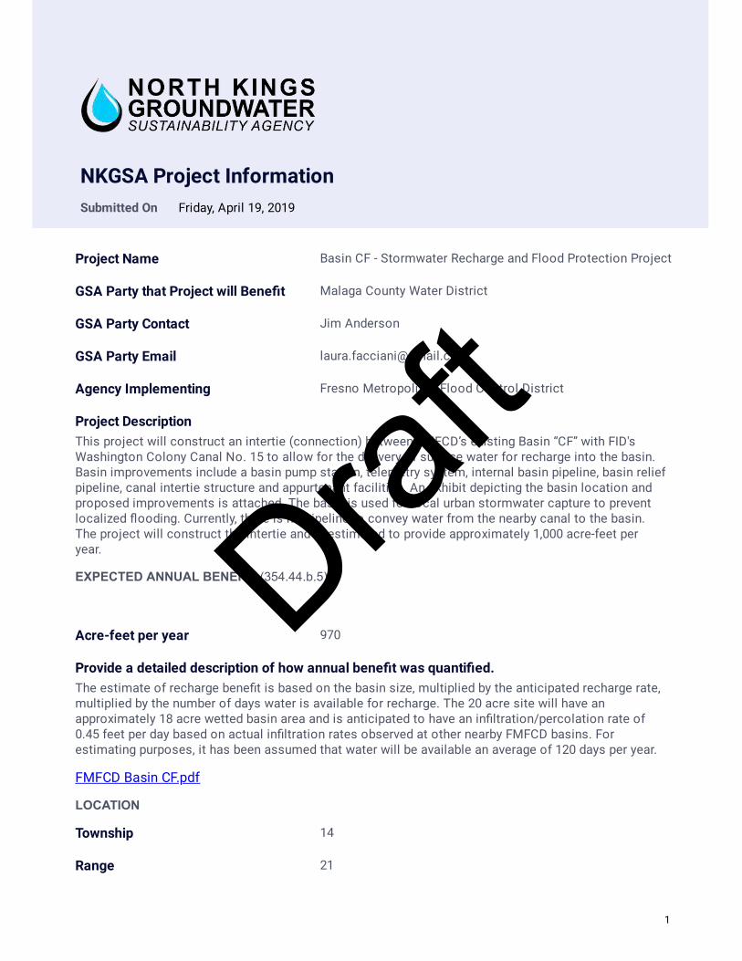
NKGSA Project InformationSubmitted On Friday, April 19, 2019
Project Name Basin CF - Stormwater Recharge and Flood Protection Project
GSA Party that Project will Bene�t Malaga County Water District
GSA Party Contact Jim Anderson
GSA Party Email [email protected]
Agency Implementing Fresno Metropolitan Flood Control District
Project DescriptionThis project will construct an intertie (connection) between FMFCD’s existing Basin “CF” with FID'sWashington Colony Canal No. 15 to allow for the delivery of surface water for recharge into the basin.Basin improvements include a basin pump station, telemetry system, internal basin pipeline, basin reliefpipeline, canal intertie structure and appurtenant facilities. An exhibit depicting the basin location andproposed improvements is attached. The basin is used for local urban stormwater capture to preventlocalized �ooding. Currently, there is no pipeline to convey water from the nearby canal to the basin.The project will construct the intertie and is estimated to provide approximately 1,000 acre-feet peryear.
EXPECTED ANNUAL BENEFIT (354.44.b.5)
Acre-feet per year 970
Provide a detailed description of how annual bene�t was quanti�ed. The estimate of recharge bene�t is based on the basin size, multiplied by the anticipated recharge rate,multiplied by the number of days water is available for recharge. The 20 acre site will have anapproximately 18 acre wetted basin area and is anticipated to have an in�ltration/percolation rate of0.45 feet per day based on actual in�ltration rates observed at other nearby FMFCD basins. Forestimating purposes, it has been assumed that water will be available an average of 120 days per year.
FMFCD Basin CF.pdf
LOCATION
Township 14
Range 21
1
Draft

Section 32
Latitude 36.675020
Longitude -119.715033
Description Southeast of Central and Peach Avenues
AFFECTED SUSTAINABILITY INDICATOR (354.44b)
Check all that apply: Chronic lowering of groundwater levels
Seawater Intrusion Land Subsidence
Reduction of groundwater storage
Degraded water quality
Depletions of interconnected surface water
Provide a narrative explanation of how the project addresses each Sustainability Indicator selected.The additional water recharged at the basin will help replenish the local aquifer and reduce declininggroundwater levels in the area of the project. Relatedly, the addition of water recharged at the basin sitewill directly help to increase the amount of groundwater storage available for pumping during dryperiods.
Type of Project Increase Supply Demand Reduction
Explain:The project will create a connection to an existing basin that will allow additional surface water supplyto recharge the aquifer.
REGULATORY/PERMITTING (354.33.b.3)
Permits
Permitting Agency Permit Type
State Water Resources ControlBoard
NPDES General Permit forStorm Water Discharge
San Joaquin Valley Air PollutionControl District Dust Control Permit
County of Fresno Grading Permit
Is CEQA Complete? Yes No
2
Draft

If complete, please explain.The project was included in the District's Subsequent Environmental Impact Report (SEIR) completedon 12/13/17 for the 2016 District Service Plan.
PROJECT STATUS Conceptual (no feasibility or study work initiated)
Planning (feasibility study and analysis workinitiated)
Preliminary Design (feasibility study completed)
Ready for Construction/Implementation
SCHEDULE (354.44.b.4)
Construction/Implementation Start Year
2021
Construction/Implementation Finish Year
2021
Timeframe to Accrue Bene�ts From 2021
Timeframe to Accrue Bene�ts To 2071
WATER SUPPLY (354.44.b.6)
If the project relies on surface water, provide an explanation of the source reliability of the water supply for the project.The project will recharge surface water delivered by Fresno Irrigation District. Malaga County WaterDistrict is currently working with Fresno Irrigation District to determine an agreement for delivery ofsurface water.
LEGAL AUTHORITY (354.44.b.7)
Describe the Agencies legal authority to implement this project.FMFCD owns and operates the existing Basin CF and will manage the design and construction of theproject. Malaga County Water District is currently discussing with FMFCD the terms of agreement forconstruction. FMFCD will maintain ownership and operation of the basin. FMFCD will coordinatesurface water deliveries for recharge with FID.
COST & FUNDING SOURCE (354.44.b.7)
Project Capital $1,072,036
Describe the funding source or how these costs will be met.The project is pursuing grant funding through the IRWM Implementation Grant program. If grant fundingcannot be secured, the FMFCD and Malaga will need to determine a different funding source for theproject.
Project O&M/On-going $10,000
Source(s)The annual operational costs are anticipated to be minimal. FID and FMFCD operational crews willcoordinate delivery of water to the basin in accordance with the existing operations for delivery of
3
Draft

water to numerous other basins. FMFCD will include maintenance activities and costs in its annualbudget for operations and maintenance, subject to existing agreements for reimbursement of basin de-siltation and weed control.
4
Draft

NKGSA Project Information
Form date: April 19, 2019
May 14, 2019Submitted On
Project Name PCWD residential meter installation
GSA Party that Project will Bene�t Pindedale County Water District
GSA Party Contact Jason Franklin
GSA Party Email [email protected]
Agency Implementing Pinedale County Water District
Project DescriptionThe District has initiated efforts to secure funding for plans to install residential water meters (including multi-unit customers) and switch from a �xed �at-rate to a volumetric rate based on consumption. The project also includes replacing 8,050 feet of old main lines. The project will be bolstered by outdoor water restrictions and conservation efforts.
EXPECTED ANNUAL BENEFIT (354.44.b.5)
Acre-feet per year 210
Provide a detailed description of how annual bene�t was quanti�ed. Studies show a range of 15% - 20% reduction in water usage when water utilities switch to volumetric charging for consumptive use. Fresno reduced it's per capita water use by 17% when it started charging a volumetric rate in 2013. To be conservative, we will expect a 10% reduction in use. In addition to letting us be able to charge for use, the meters have leak detection technology that will enable us to notify customers of on-site leaks.
pacinst-metering-in-california.pdf
LOCATION
Township 12
Range 20
Section 33
Latitude 36.842012
Longitude -119.801209
1
Draft

Description Location is District o�ce. Project is District wide.
AFFECTED SUSTAINABILITY INDICATOR (354.44b)
Check all that apply: Chronic lowering of groundwater levels
Seawater Intrusion Land Subsidence
Reduction of groundwater storage
Degraded water quality
Depletions of interconnected surface water
Provide a narrative explanation of how the project addresses each Sustainability Indicator selected.The reduction in demand will relieve stress on the local aquifer, aiding the natural recharge to replenish the amount of groundwater storage.
Type of Project Increase Supply Demand Reduction
Explain:Customers will use water more conservatively when they are being charged a volumetric rate.
REGULATORY/PERMITTING (354.33.b.3)
Is CEQA Complete? Yes No
PROJECT STATUS Conceptual (no feasibility or study work initiated)
Planning (feasibility study and analysis workinitiated)
Preliminary Design (feasibility study completed)
Ready for Construction/Implementation
Planning (feasibility study and analysis workinitiated)
SCHEDULE (354.44.b.4)
Construction/Implementation Start Year
2022
Construction/Implementation Finish Year
2022
Timeframe to Accrue Bene�ts From 2023
Timeframe to Accrue Bene�ts To 2073
WATER SUPPLY (354.44.b.6)
If the project relies on surface water, provide an explanation of the source reliability of the water supply for the project.
2
Draft

N/A
LEGAL AUTHORITY (354.44.b.7)
Describe the Agencies legal authority to implement this project.Pinedale County Water District owns, operates, and maintains the distribution system that the new meters will be connected to.
COST & FUNDING SOURCE (354.44.b.7)
Project Capital $7,000,000
Describe the funding source or how these costs will be met.Cost is a rough estimate. We are pursing State funding which should cover half the project cost. The remainder will be funded through a long-term loan.
Project O&M/On-going $35,000
Source(s)This cost covers the subscription costs for using the system and normal repair/replacement of meters and transponders.
3
Draft