Draft GLENDALE MASTER PLAN - Gemini...
107
Prelim Draft Glendale Master Plan Page 1 Preliminary Draft GLENDALE REGIONAL CENTRE MASTER PLAN Master Plan and Background Report March 2008 Lake Macquarie City Council and Strategy Hunter consultants
-
Upload
nguyenduong -
Category
Documents
-
view
216 -
download
0
Transcript of Draft GLENDALE MASTER PLAN - Gemini...
Prelim Draft Glendale Master Plan Page 1
Preliminary Draft GLENDALE REGIONAL CENTRE MASTER PLAN
Master Plan and Background Report March 2008
Lake Macquarie City Council and Strategy Hunter consultants

Prelim Draft Glendale Master Plan Page 2
Prelim Draft Glendale Master Plan Page 3
Contents Executive Summary ....................................................................................................... 8
Preliminary Draft GLENDALE REGIONAL CENTRE MASTER PLAN ...................... 11
MASTER PLAN CONTENTS....................................................................................... 12
Principles of the Glendale Regional Centre Master Plan ........................... 13
The overall framework .................................................................................... 15
The role of Glendale ....................................................................................... 17
Sustainability ................................................................................................... 18
Activities .......................................................................................................... 27
Access and Movement ................................................................................... 28
Public Places and Spaces (Public Realm) ................................................... 35
Open Space system ........................................................................................ 36
Housing ............................................................................................................ 38
Area Plans ........................................................................................................ 39
Process ............................................................................................................ 39
BACKGROUND REPORT ........................................................................................... 41
Introduction .................................................................................................................. 43
Objectives of this Project: ............................................................................................ 43
Objectives for Glendale ............................................................................................... 43
The Role of the Master Plan and Background Report ................................................ 44
Location ........................................................................................................................ 45
Description of the Study Area: ..................................................................................... 46
Lower Hunter Regional Strategy ................................................................................. 49
Lifestyle 2020 ............................................................................................................... 50
The Draft Structure Plan for Glendale/Cardiff ............................................................. 50
Lake Macquarie Local Environmental Plan - Land Use Zoning .................................. 51
Physical Infrastructure ................................................................................................. 53
Community Services .................................................................................................... 53
Medicare ............................................................................................................... 53
Centrelink .............................................................................................................. 53
Child Care ............................................................................................................. 53
Youth ..................................................................................................................... 53
Prelim Draft Glendale Master Plan Page 4
Community Centre ................................................................................................ 54
Library ................................................................................................................... 54
Section 94 for Community Facilities ..................................................................... 54
Education ..................................................................................................................... 55
Emergency Services .................................................................................................... 55
Mine Subsidence ......................................................................................................... 55
Site Contamination ....................................................................................................... 59
Flooding........................................................................................................................ 61
Bushfire Risk ................................................................................................................ 62
Visual Analysis ............................................................................................................. 63
Heritage ........................................................................................................................ 69
Indigenous Heritage ............................................................................................. 69
European Heritage ............................................................................................... 69
Natural environment ..................................................................................................... 71
Public Transport. .......................................................................................................... 75
Roads ........................................................................................................................... 76
Lake Macquarie Transport Interchange (LMTI) ........................................................... 76
Public Transport Components .............................................................................. 77
Road Link Components ........................................................................................ 78
Synopsis of Transport Interchange Impacts ........................................................ 80
Glendale Stockland Centre .......................................................................................... 81
Hunter Sports Centre ................................................................................................... 81
Civic and Community Role .......................................................................................... 83
Sustainability ................................................................................................................ 85
Setting the Context for a Regional Centre................................................................... 87
Glendale Regional Centre and Corridors- Precinct Assessment ................................ 89
Precinct 1 Main Road ........................................................................................... 89
Precinct 2 Lake Road .......................................................................................... 91
Precinct 3 The Crossroads ................................................................................... 92
Precinct 4 Intensive Regional Centre ................................................................... 94
Precinct 5 Hunter Sports Centre ......................................................................... 97
Precinct 6 Former Cardiff Railway Workshops ................................................... 97
Precinct 7 Winding Creek Riparian Corridor ........................................................ 98
Prelim Draft Glendale Master Plan Page 5
Precinct 8. ―Pasminco‖ Redevelopment Site ....................................................... 98
Precinct 9. Cardiff Industrial Area ........................................................................ 99
Precinct 10 Cardiff Town Centre ....................................................................... 100
Appendix 1: Relevant Land Use Tables from the Lake Macquarie Local Environmental Plan 2004 ........................................................................................... 102
Appendix 2: Likelihood of Threatened Species on Site ............................................ 106
Prelim Draft Glendale Master Plan Page 6
Figure 1- Glendale Regional Centre and the Redevelopment Corridors .................... 16
Figure 2- Glendale Regional Centre Precincts ............................................................ 20
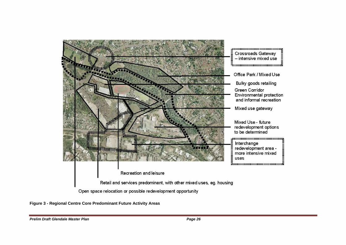
Figure 3 - Regional Centre Core Predominant Future Activity Areas ......................... 26
Figure 4- Pedestrian and Cyclist Network "Backbone" ............................................... 31
Figure 5- Road Hierarchy ............................................................................................ 33
Figure 6 - Glendale Open Space System.................................................................... 37
Figure 7: Location of Glendale .................................................................................... 45
Figure 8- Glendale Regional Centre: orientation......................................................... 46
Figure 9 - Location of Regional Centre Street System ............................................... 47
Figure 10: Artist's Impression: Glendale Transport Interchange ................................ 48
Figure 11: Glendale Regional Centre Major Property Owners ................................... 49
Figure 12: Zoning of the Glendale Regional Centre and the Corridors ...................... 52
Figure 13: Extent of mine subsidence ......................................................................... 57
Figure 14: Past Mining Constrained Development Potential ...................................... 59
Figure 15: Flood prone land......................................................................................... 62
Figure 16- Bushfire Prone Areas ................................................................................. 63
Figure 17: Visual analysis ............................................................................................ 64
Figure 18: Main Road looking west to Edgeworth....................................................... 65
Figure 19: Main Rd looking towards the Crossroads .................................................. 65
Figure 20: Lake Road looking north towards Stockland Drive. ................................... 66
Figure 21- Visual clutter at the Stockland Drive entry ................................................. 67
Figure 22 -The Crossroads in the 1960's before the traffic lights ............................... 67
Figure 23- The Crossroads today ................................................................................ 68
Figure 24- Car Dominance of the Stockland Centre ................................................... 68
Figure 25- Winding Creek ............................................................................................ 69
Figure 26- The Railway Workshops in operation: note the scale of the main building ...................................................................................................................................... 70
.Figure 27- Ecological Value of the Study Area (ERM 2007) ...................................... 73
Figure 28 - Previously the "bus interchange" was at the Crossroads (1960's) .......... 75
Figure 29- Glendale Bus Interchange ......................................................................... 75
Figure 30- Components of the Lake Macquarie Transport Interchange (LMTI) ......... 77
Figure 31: Major Roads- existing and proposed ......................................................... 79
Figure 32- Hunter Sports Centre: Existing and Proposed Facilities ........................... 82
Prelim Draft Glendale Master Plan Page 7
Figure 33 - The Evolution of Civic Centres.................................................................. 84
Figure 34 - Glendale in relation to the Main Road and Lake Road Corridors ............ 88
Figure 35- Precincts comprising the Glendale Regional Centre and surrounds ........ 89
Prelim Draft Glendale Master Plan Page 8
Executive Summary
The Glendale Regional Centre Master Plan comprises two sections:
A Background Paper
The Master Plan
The objective of the Master Plan is to provide broad direction for the development of the Glendale Regional Centre. It will be complemented by a series of Area Plans which will provide more detailed guidelines for the development of the Precincts within the Regional Centre. These Area Plans will be consistent with the Master Plan, which will provide a unifying reference point.
The Glendale area is significant for Lake Macquarie City and the Lower Hunter. It offers the ability to establish a new transit oriented regional centre.
Glendale will become one of the three major centres of the Lake Macquarie Local Government Area, the others being Charlestown and Morisset. Glendale has a number of advantages over these Centres in performing the role of the Lake Macquarie ―City Centre‖. In particular, it is equally accessible from the eastern and western sides of the Lake. It has the advantage of being the site of a proposed major transport interchange (Glendale Transport Interchange- GTI) for both rail and road based transport. Glendale is also very accessible to the adjacent Local Government Areas of Wyong, Cessnock, Maitland, Newcastle and Port Stephens because of its ready access to the Freeway.
The new Glendale Regional Centre provides an opportunity to create vibrant civic and community spaces which provide a focus for, and which reflect, the culture and lifestyle of the Lake Macquarie community; and its early stage of development provides a strategic opportunity to apply techniques to significantly reduce resource consumption and to manage the ecological footprint of the Centre.
The Glendale Regional Centre consists of a core area bounded by Lake Road, Main Road, the railway line and the boundary of the Stockland Centre. It also has a number of redevelopment corridors radiating from the core- Lake Road to Cockle Creek, and Main Road from Edgeworth to the Railway Underpass at Cardiff.
There are substantial redevelopment opportunities within the Regional Centre.
The Lake Macquarie Transport Interchange (LMTI), which brings together rail, bus and other modes of transport in an integrated interchange, will provide the focus for the movement of people in the Regional Centre. It will also be the point of most intensive development. Road links associated with the Interchange will substantially improve access to other parts of Lake Macquarie and beyond, and will provide relief to existing intersections, such as that at the junction of Munibung and Macquarie Road. The Interchange is a development of regional significance.
Challenges in the development of the Regional Centre include:
Providing an identifiable social, cultural, commercial and recreational focus for the people of Lake Macquarie
Providing a high standard of urban design and landscaping
Ensuring a pedestrian friendly environment and reducing the dominance of motor vehicles
Prelim Draft Glendale Master Plan Page 9
Ensuring that development is well sequenced over the period of development of the Regional Centre
Ensuring development in the short term does not compromise long term development potential
Managing the impact of constraints, such as mine subsidence, relative to achieving a critical mass of development
Restoring the environment of Winding Creek
Providing a mix of uses and activity which delivers a vibrant, unique and safe Regional Centre
Providing multipurpose converged community services and facilities
Providing a process that achieves long term co-ordination and commitment for the innovative development and management of the Regional Centre.
The Master Plan aims to play an important part in meeting these challenges.

Prelim Draft Glendale Master Plan Page 10
Prelim Draft Glendale Master Plan Page 11
Preliminary Draft GLENDALE REGIONAL CENTRE MASTER PLAN
March 2008
Strategy Hunter consultants
Prelim Draft Glendale Master Plan Page 12
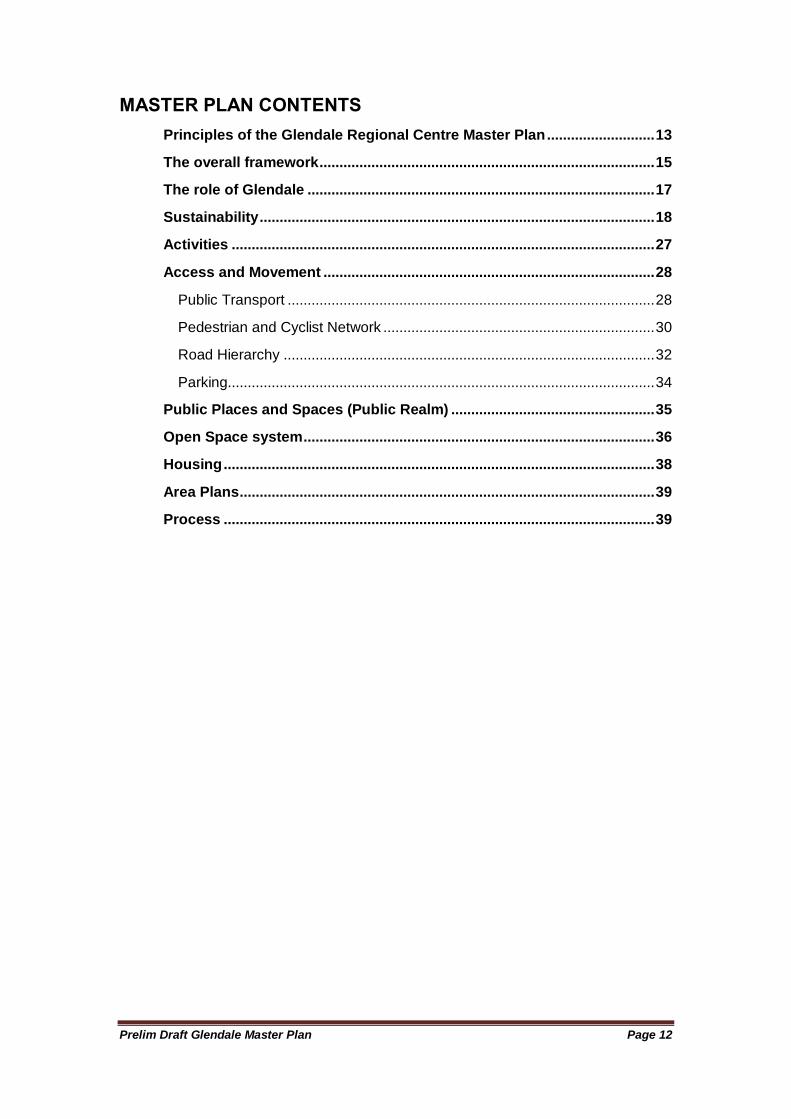
MASTER PLAN CONTENTS
Principles of the Glendale Regional Centre Master Plan ........................... 13
The overall framework .................................................................................... 15
The role of Glendale ....................................................................................... 17
Sustainability ................................................................................................... 18
Activities .......................................................................................................... 27
Access and Movement ................................................................................... 28
Public Transport ............................................................................................ 28
Pedestrian and Cyclist Network .................................................................... 30
Road Hierarchy ............................................................................................. 32
Parking........................................................................................................... 34
Public Places and Spaces (Public Realm) ................................................... 35
Open Space system ........................................................................................ 36
Housing ............................................................................................................ 38
Area Plans ........................................................................................................ 39
Process ............................................................................................................ 39
Prelim Draft Glendale Master Plan Page 13
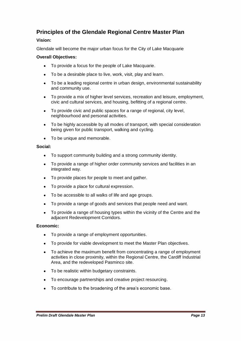
Principles of the Glendale Regional Centre Master Plan
Vision:
Glendale will become the major urban focus for the City of Lake Macquarie
Overall Objectives:
To provide a focus for the people of Lake Macquarie.
To be a desirable place to live, work, visit, play and learn.
To be a leading regional centre in urban design, environmental sustainability and community use.
To provide a mix of higher level services, recreation and leisure, employment, civic and cultural services, and housing, befitting of a regional centre.
To provide civic and public spaces for a range of regional, city level, neighbourhood and personal activities.
To be highly accessible by all modes of transport, with special consideration being given for public transport, walking and cycling.
To be unique and memorable.
Social:
To support community building and a strong community identity.
To provide a range of higher order community services and facilities in an integrated way.
To provide places for people to meet and gather.
To provide a place for cultural expression.
To be accessible to all walks of life and age groups.
To provide a range of goods and services that people need and want.
To provide a range of housing types within the vicinity of the Centre and the adjacent Redevelopment Corridors.
Economic:
To provide a range of employment opportunities.
To provide for viable development to meet the Master Plan objectives.
To achieve the maximum benefit from concentrating a range of employment activities in close proximity, within the Regional Centre, the Cardiff Industrial Area, and the redeveloped Pasminco site.
To be realistic within budgetary constraints.
To encourage partnerships and creative project resourcing.
To contribute to the broadening of the area‘s economic base.
Prelim Draft Glendale Master Plan Page 14
Environmental
To apply innovative resource efficiency and carbon emission reduction techniques and practices.
To provide sustainable water cycle management by minimising the consumption of imported water supplies, and improve downstream water quality.
To encourage a ―whole of Regional‖ Centre approach to minimising resource management and efficient water cycle management.
To repair the riparian corridor and functions of Winding Creek.
To protect any areas of environmental significance.
To provide a high standard of urban design and landscaping.
To achieve high levels of ―walkability‖ in order to reduce motor vehicle dependency.
To provide for and encourage alternative means of transport, such as bicycling and public transport.
To provide practical demonstrations of development that has a low environmental impact and a low resource consumption, that can be applied elsewhere in Lake Macquarie.
Prelim Draft Glendale Master Plan Page 15
The overall framework
Principle:
The regional centre will be supported by a mix of intensive land uses and will be highly accessible by all transport modes.
Outcomes:
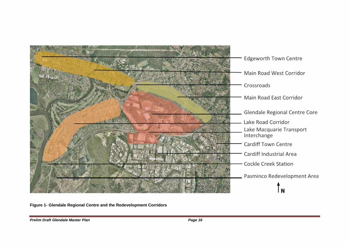
- The framework of Glendale is of a ―core‖ Regional Centre and a number of redevelopment corridors, as shown in the figure below.
- Each of the elements comprising the Regional Centre inter-relate and perform a complementary role in achieving a viable vibrant centre.
- Complementary mixed use is encouraged in all Precincts.
- The most intensive elements from a development perspective are the Crossroads and the vicinity of the Transport Interchange.
- A green spine (Winding Creek) runs through the Regional Centre connected to a pedestrian and cycle network.
- Development relates to and addresses the pedestrian network rather than to the road network (although both should be addressed as much as possible).
- Where the public space is within privately owned land, it should operate in an unimpeded fashion, as would be expected for public land.
Prelim Draft Glendale Master Plan Page 16
Figure 1- Glendale Regional Centre and the Redevelopment Corridors
Prelim Draft Glendale Master Plan Page 17
The role of Glendale
Principle:
The Regional Centre will provide an urban focus for the City of Lake Macquarie
Outcomes:
- Glendale will be the major regional community centre for Lake Macquarie.
- It should contain a range of higher order services, retailing, public spaces, as well as civic and community facilities that reflect this role.
- It should be a major service point for a range of Government services and be the most intensively developed part of the Glendale/Cardiff employment node.
- Significant redevelopment of the Main Road and Lake Road corridors should be encouraged.
- These Corridors should provide medium density housing to meet the needs of the Lake Macquarie community and to support a vibrant Regional Centre.
- Glendale should continue to be a regional focus of athletic activity with the further development of indoor and outdoor facilities at the Hunter Sports Centre.
- The transport interchange should include the major railway station for Lake Macquarie.
- The transport interchange should enable people to conveniently and safely access a range of transport modes, with direct services to major destinations throughout Newcastle and Lake Macquarie.
Prelim Draft Glendale Master Plan Page 18
Sustainability
Principle:
The Regional Centre will provide a practical example of urban development that has a reduced carbon footprint and environmental impact
Outcomes:
- Development should apply energy efficient technology, design and operational practices.
- Walking, cycling and public transport should be the preferred modes of transport.
- Buildings should be constructed with a view to reducing resource consumption over their life cycle.
- The Winding Creek corridor should be rehabilitated to allow it perform its conservation, recreation and open space roles.
- Developments should consider the energy efficiency strategies which complement the strategies of neighbouring developments and may assist in meeting the needs of their neighbours (i.e. a ―whole of Regional Centre‖ approach should be taken).
- Mixed use should reduce motor vehicle usage.
- Medium density housing within and adjacent to the Regional Centre should improve spatial access to a diversity of services and employment options in order to reduce motor vehicle usage and commuting.
- The Transport Interchange should cater for all transport modes.
- The following strategies should also be investigated:
o Reticulated treated effluent reuse from the Edgeworth Waste Water Treatment Works
o Energy cogeneration
o Use of mine water and methane gas discharges
o Utilisation of watercourse and riparian corridors to provide pedestrian and cycle paths and an passive recreation network
o Opportunities to improve water downstream.
Prelim Draft Glendale Master Plan Page 19
Urban Structure and Form
Principle: The Regional Centre will be structured around a series of well linked activity nodes and places, built around a “green spine”. Outcomes:
- The Regional Centre has a central spine of green space in the form of the Winding Creek riparian corridor.
- The green spine provides a contrast to the highly urbanised components of the regional centre, and a place of relaxation for the worker, residents and visitors of the Centre.
- A well defined pedestrian and cycle network provides entry points to the green spine as well as safe direct routes to the major destinations of the Centre.
- The Hunter Sports Centre to the south, and an office park mixed use area to the north of the green spine provide a transition to more intensive areas of activity.
- Reflective of the opportunities presented by the locality, two areas provide the highest development intensity, namely the Crossroads and the Transport Interchange.
- The Crossroads has high visibility and should be developed to provide a symbolic gateway to the Regional Centre.
- The Transport Interchange is the point of highest multimodal transport accessibility, is relatively unconstrained by mining, and its surroundings should be redeveloped with mixed use development which capitalises on the proximity of the Interchange.
- Mixed use should be apparent throughout the Regional Centre. However, each area should have a dominant theme, permitting the clustering of similar land uses for efficiency, amenity and operational management reasons.
- The arterial road network consisting of Lake Road, Main Road and Pennant Street extended/Glendale Drive extended should provide the vehicular access to the site.
- Stockland Drive should be a subarterial road linking Lake Road with Pennant Street extended/ Glendale Drive extended.
- Local roads should be designed to reduce vehicle speeds and to increase connectivity.
- All roads must be constructed to a suitable level of service to enable the Regional Centre to operate effectively, both in terms of traffic circulation and bus access.
- A series of Area Plans should be developed to correspond to the Precincts will comprise the Regional Centre.
Prelim Draft Glendale Master Plan Page 20
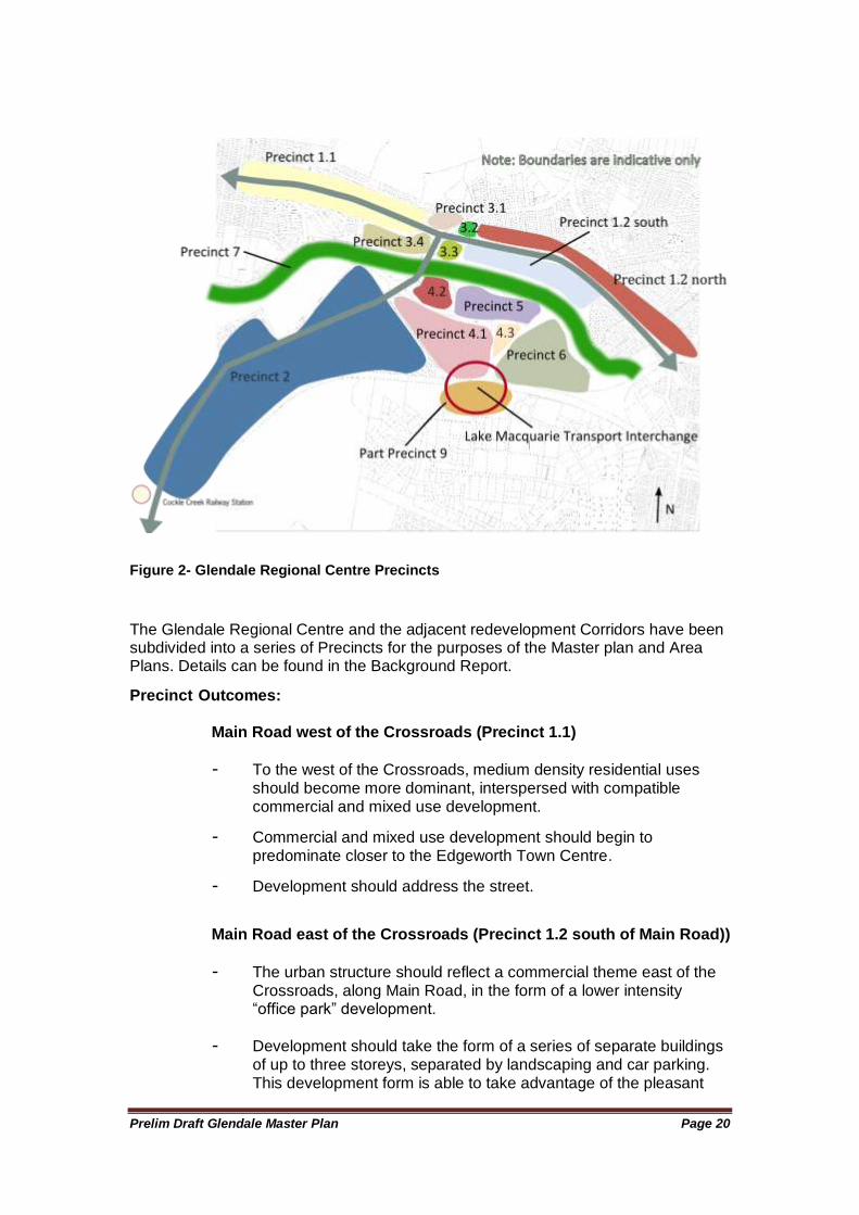
Figure 2- Glendale Regional Centre Precincts
The Glendale Regional Centre and the adjacent redevelopment Corridors have been subdivided into a series of Precincts for the purposes of the Master plan and Area Plans. Details can be found in the Background Report.
Precinct Outcomes: Main Road west of the Crossroads (Precinct 1.1)
- To the west of the Crossroads, medium density residential uses should become more dominant, interspersed with compatible commercial and mixed use development.
- Commercial and mixed use development should begin to predominate closer to the Edgeworth Town Centre.
- Development should address the street.
Main Road east of the Crossroads (Precinct 1.2 south of Main Road))
- The urban structure should reflect a commercial theme east of the Crossroads, along Main Road, in the form of a lower intensity ―office park‖ development.
- Development should take the form of a series of separate buildings of up to three storeys, separated by landscaping and car parking. This development form is able to take advantage of the pleasant
Prelim Draft Glendale Master Plan Page 21
environmental corridor (green spine) to the south, as well as efficiently manage the constraints of mine subsidence.
- Other uses, including residential, open space and limited retail can be accommodated as an integrated component of the office park.
Lake Road south of the Crossroads (Precinct 2)
- To the south of Stockland Drive, medium density residential uses should become more dominant, interspersed with compatible commercial and mixed use development.
- Development in this corridor should be more intensive than the Main Road corridor, reflecting the relative absence of mine subsidence constraints
- Commercial and mixed use development should predominate around the Argenton commercial node.
- The urban form of the Mines Rescue Station and surrounds should continue to reflect its heritage significance.
- Entertainment and recreation uses should focus around the Golf Club and Club Macquarie at the western end of the Corridor.
- More intensive development should be considered for part of the Club Macquarie site to take advantage of the proximity of Cockle Creek railway station.
- Development should address the street.
The Crossroads (Precinct 3)
- The Crossroads should have a strong commercial theme, reflecting its high ―landmark‖ visibility but also the constraints of vehicular access close to the busy intersection. High quality urban design is required. For many, this will be the public gateway to the Centre.
- A built up edge to the property boundaries on intersection or landmark landscaping treatment should be provided to all corners of the Crossroads. Located at the intersection of Main Road and Lake Road, the Crossroads provides the most significant high profile gateway to the Regional Centre.
- Buildings on the Crossroads corners should be a minimum of three storeys in height, with higher buildings of 5 storeys encouraged subject to mine subsidence assessment.
- Should the open space function continue on the southwest corner, landscaping should reflect the intensive built up urban edge of the development on the other corners.
- Two pedestrian routes should link the Crossroads with the Transport interchange. One relatively direct route runs via the green spine and an entertainment area and plaza, discussed below. The other pedestrian route runs along Lake Road to connect with two alternative routes to the Transport Interchange, also discussed later.
Prelim Draft Glendale Master Plan Page 22
- Car parking at the Crossroads should be located behind the built edge.
- Specific urban design guidelines should be produced for the Crossroads Precinct as part of the Area Plan before significant development occurs.
Glendale “Town Centre” (Precinct 4)
- The ―Town Centre‖ should be an intensive mixed use area with a high degree of connectivity within the Town Centre and external to the Town Centre.
- The function and built form of the periphery of the Town Centre should relate to the adjacent Precincts and incorporate appropriate transitional areas.
- The Town Centre should exhibit a high standard of urban design, which particular attention being paid to buildings such as car parks
Transport Interchange Redevelopment Area (Part Precinct 4 and 9)
- The vicinity of the Transport Interchange provides the greatest opportunity for high intensity mixed use development. Multistorey buildings providing office, residential, and community services delivery points or a mix of both uses should be located here, with a high people activity use at the ground floor, such as retail or high volume personal services delivery.
- The highest intensity of land use and people movement should occur in the vicinity of the interchange, thus encouraging higher value land uses to develop, such as multistorey offices. This area is one of the least affected by mine subsidence, allowing it the ability to reach its potential unfettered by that constraint.
- Higher intensity land use should also occur to the south of the railway station. In particular, the area zoned 4(3) Industrial (Urban Services) should be redeveloped at a higher intensity to take maximum advantage of the transport interchange and to avoid a ―lop-sided‖ walkable catchment for the railway station.
- The land use on the sites surrounding the Transport Interchange is flexible, however they should reflect the high accessibility of this site by all modes of transport, the relative absence of mine subsidence constraints and the appropriateness of the use as part of the core of a Regional Centre.
- Redevelopment of the vicinity of the Transport Interchange should ensure that the accessibility of the Transport Interchange to other parts of the Regional Centre is maximised.
Prelim Draft Glendale Master Plan Page 23
Transport Interchange Plaza (within Precinct 4)
- The character of the vicinity of the Transport Interchange should be very urban, with a formal public plaza adjoining the Transport Interchange.
- The formal Transport Interchange public plaza should be structured to provide an environment that provides navigational cues from the public transport entries to the major uses on site, with well defined and well structured pedestrian networks radiating from the Plaza.
- The Transport Interchange plaza, should be flanked by uses which activate it over much of the day and night, so as to provide security for transport users and an urban vibrancy that extends the role of the Plaza from a just a place to wait for the next bus or train, to a place of welcome to the Regional Centre and as a destination in its own right.
Stockland Centre (Precinct 4.1)
- The urban structure of the Stockland site should vary across the site. However, it should exhibit an increasing intensity of development from its periphery to the Transport Interchange.
- The future expansion of the Stockland Centre should incorporate a greater range of uses, and the diversity of uses should be reflected in its built form
- The visual car dominance of the Stockland Centre should be reduced through the provision of a limited number of ―centralised‖ multistorey car parks, with access from Stockland Drive
- Connectivity within the Precinct should be achieved through the introduction of a rectilinear grid pathway and road system. Low volume low speed motor vehicle movement and on street car parking should be permitted within some of the internal roads.
- Two major pedestrian routes should traverse the Stockland site, both radiating from the Transport interchange.
o One pedestrian route should run north south and link the Transport Interchange Plaza to the Hunter Sports Centre. This pedestrian route could take the form of a linear ―park‖ interspersed with commercial ―kiosk‖ outlets.
o The second major pedestrian route runs along the front of the shops, heading generally westwards towards Lake Road.
- Entertainment and leisure activities should be co-located in an ―Entertainment Area‖, in the vicinity of the cinemas and the Hunter Sports Centre.
- Adjacent to Lake Road, gateway buildings should address both Lake Road and Stockland Drive. These structures would house uses which contribute to, and benefit from, the public exposure of
Prelim Draft Glendale Master Plan Page 24
their location. The external design of these gateway buildings should help establish a clear identity for the Regional Centre, and provide cues for the diversity of uses it contains. The nature of these buildings and their functions also signal the transition to the more residentially themed Lake Road redevelopment corridor to the south.
- The Stockland Drive periphery of the Stockland site should reflect its retail focus, and have a street wall height of some two to three storeys.
- Development along Stockland Drive should address the street, it being a major subarterial route into the core of the Regional Centre and the major public edge of the retail heart of the Centre.
- A pedestrian route should run along Stockland Drive linking the ―Entertainment Area‖ with Lake Road, effectively linking the ends of the two pedestrian routes mentioned earlier.
- Whilst the Stockland Centre should focus on retail and personal services, it should have a business services and housing component. The location of housing close to transport and services makes the area suitable for a range of housing markets, including the aged. Tourist accommodation may also be suitable on part of the site. A mix of land uses should add another dimension and greater vitality to the Centre.
Lake Road Bulky Goods Area (Precinct 4.2)
- To the north of Stockland Drive and immediately east of Lake Road should be an extended area of bulky goods retailing. The setback nature of the sites off Lake Road should allow redevelopment for this land use to occur whilst minimising its visual impact on the public realm.
Former Railway Workshops Oval (Within Precinct 4.1)
- The former Railway Workshops Oval and its surrounds should provide a location for mixed use activity or potentially civic and community related facilities.
- It is a gateway site, located at the intersection of Stockland Drive and Pennant Street extended/ Glendale Drive extended.
- It is an ideal location for higher order community facilities, due to its location close to an entertainment leisure precinct, the Sports Centre and the Transport Interchange.
- The built form should symbolically express its civic/community function as part of its gateway function.
Prelim Draft Glendale Master Plan Page 25
Hunter Sports Centre (Precinct 5)
- The Hunter Sports Centre should further develop and intensify as a provider of sports and athletic activities to both the region and the growing local population of the Regional Centre and its surroundings.
- New development on the site should relate more strongly to the ―Town Centre‖ and reflect an increasing multipurpose community facility function.
Railway Workshops site (Precinct 6)
- The future options for the Railway Workshops site are unclear, given the uncertain length of tenure of the industrial operations on site, which may be long term.
- The Railway Workshops area has been notionally identified as ―mixed use‖ and vehicular and pedestrian routes designed so as to facilitate its possible redevelopment as an integral part of the Regional Centre.
- That part of the Railway Workshops site closest to the railway line is relatively unaffected by mine subsidence, and offers the potential of high intensity mixed use development.
- Planning and development decisions elsewhere in the Regional Centre should be made on the assumption that the Railway Workshop site should be redeveloped. Accordingly, connectivity and relationships with the ―Town Centre‖ and the Transport Interchange should be facilitated.
Winding Creek Corridor (Precinct 7)
- The Winding Creek Corridor should provide for informal recreation (such as a cross country running trail) and environmental restoration. Intensive development of recreational facilities within the Corridor should not occur.
- The boundaries of the Corridor should be defined through additional environmental studies.
- The Winding Creek Corridor forms part of a subregional waterway and open space network, and linkages to the east and west should be encouraged.
- A Rehabilitation and Management Plan for the Winding Creek Corridor should be developed and implemented.
Prelim Draft Glendale Master Plan Page 26
Figure 3 - Regional Centre Core Predominant Future Activity Areas
Prelim Draft Glendale Master Plan Page 27
Activities
Principle:
The Regional Centre will support a range of regional level social and economic activities in a mixed use setting.
- The Glendale Regional Centre should provide a range of higher and lower order land uses and activities commensurate with the functions of a Regional Centre.
- Activities within the Centre should include:
Transport Interchange
General retail
Bulky goods retail
Personal services
Informal and formal recreation
Community and civic functions
Commercial and office
Business Services
Entertainment
Cultural
Housing
- Activities are provided for in a variety of settings, from sites dedicated to a single use through to mixed use sites.
- Compatible mixed use settings are preferred.
- A mix of uses in a variety of contexts should add vibrancy to the area, improve security, and provide robustness to allow buildings and places to adapt to changing community needs and preferences.
- Housing is encouraged within the Regional Centre as a means of enlivening places, broadening the services provided and extending the number of hours in the day during which activity occurs.
- General activity levels should intensify in areas of high transport accessibility, such as the Transport Interchange.
- A pedestrian and bicycle network should directly link areas of high activity or to provide access to the major entry points to the Regional Centre.
- The high volume vehicular activity has been confined to arterial and subarterial roads. Other motor vehicle routes should be designed to provide for low volumes or specific site access, and to provide peripheral benefits such as connectivity, added activity and surveillance of public spaces.
- Activity levels in the green spine should be limited. This area is intended for environmental restoration, water management, and informal recreation within
Prelim Draft Glendale Master Plan Page 28
the Winding Creek corridor. More active recreational activities should take place in the Hunter Sports Centre and playing fields.
- A number of public plazas should provide for informal and formal gatherings and events. These plazas include:
the Transport Interchange Plaza,
the Entertainment Plaza, and
a Civic Plaza should Council decide to locate civic and public administration activities in the Regional Centre (which is appropriate and desirable).
- Provision should be made for a public space or plaza within the former Railway Workshop site, should it be redeveloped.
Access and Movement
Principle: Glendale will be highly accessible by all modes of transport.
An efficient access and movement system within the Glendale Regional Centre is essential to it achieving its potential. The Regional Centre is to be highly walkable.
Outcomes:
- Glendale should be a highly accessible regional centre with access by walking, cycling, rail, bus and motor vehicle.
- Adequate provision should be made for all these transport models, however priority should be given to public transport, walking and cycling in the design of movement systems. These three modes should provide a primary consideration in determining the development layout and form of the Regional Centre.
- The Regional Centre should be designed to reduce the impact of through traffic.
- The Pennant Street extended/Glendale Drive extended and the associated over bridge should be designed so as reduce any negative impact on the functioning of the Regional Centre, and the ability of the former Railway Workshops to form an integral part of the Regional Centre if it is redeveloped in the future.
Public Transport
Principle:
The Transport Interchange will provide for public transport that is safe and convenient.
Outcomes:
- The Transport Interchange is the heart of the public transport system serving Glendale.
Prelim Draft Glendale Master Plan Page 29
- The design of the Interchange and the road system should enable buses to reach the Interchange in a relatively unimpeded fashion.
- No part of the core of the Regional Centre is to be more than a 1000 metre walk from the Transport interchange and 400 metres from a bus stop.
- Bus stops should be located at convenient and secure locations throughout the Regional Centre, and on the shared pedestrian and cycle path network.
- The shared pedestrian and cyclist network should provide safe unimpeded access to the Transport Interchange for all members of the community.
- Special management arrangements and agreements should be reached for those parts of the network on private land, such as within the Stockland Centre, in order to ensure equitable public access.
- Surrounding sites should be developed in an integrated fashion with the Transport Interchange, particularly within the identified Transport Interchange Redevelopment area. Integration should include:
Planning for uses that capitalise on, and support, the Transport Interchange
Providing for efficient linkages to the Transport Interchange
Providing surveillance of, and activity on, the public areas leading to and adjacent to the Transport Interchange
Providing supportive infrastructure, such as shared commuter car parking and bicycle storage.
- The Transport Interchange should generate a demand for commuter car parking, which should be provided in conjunction with other car parking requirements in the vicinity.
- Integration of commuter car parking with the needs of the Stockland Centre should be pursued.
- The commuter car park should directly link with the railway station at grade by offering commuter car parking on the upper levels.
- Mechanisms and agreements should be established to ensure the provision of the above car parking arrangements, should the timeframes of development of the interchange and Stockland car park differ.
- The public transport network operations should respond to the Transport Interchange by providing co-ordinated timetables (bus-bus and bus-rail)
- Direct trunk routes should be provided to major destinations including the University, John Hunter Hospital, Charlestown, Newcastle, Belmont and Toronto.
- Effective transit information should be made available to the community. Route maps and public transport timetables, and real time arrivals and departures information, should be made available at key locations within the Glendale Regional Centre.

Prelim Draft Glendale Master Plan Page 30
Pedestrian and Cyclist Network
Principle:
Regional Centre will be designed to meet the needs of pedestrians, and to ensure its walkability as a priority.
Outcomes:
- Walkability is a key objective of the design of the Regional Centre. The basic pedestrian network is shown in the figure below.
- The principle of the pedestrian network is to link major destinations and entry points of the Glendale Regional Centre as directly as possible.
- The design of the development on adjacent sites should respond to the pedestrian network by providing activation and surveillance to provide a variety of experiences on, and improve security of, the network.
- Awnings should provide shade and shelter for pedestrians, particularly along the routes defined on the network plan.
- Along the network there are a number of focus points where several of the most significant routes intersect or a major destination exists. Two of these points are the location of significant public places, namely the Entertainment Plaza and the Transport interchange Plaza. Each of these Plazas should be designed to allow the free movement of cyclists and pedestrians as well as space for people to meet and congregate.
- Adjacent to these plazas (and at other major destinations) cyclist facilities, particularly secure bicycle storage, such as bicycle lockers should be provided.
- All significant developments should provide cycle racks in a secure location. The major employers should provide cyclist facilities such as bicycle storage, lockers and showers.
- The detail of the pedestrian and cyclist networks should be designed to recognise the differing needs of commuting and recreational users.
- The network shown in the figure below shows the primary pedestrian and cyclist network (―the backbone‖).
- The detail of the pedestrian network should be supplemented as development occurs to ensure the ease of access of pedestrians and cyclists to locations throughout the Regional Centre.
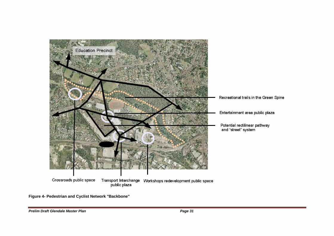
Prelim Draft Glendale Master Plan Page 31
Figure 4- Pedestrian and Cyclist Network "Backbone"
Prelim Draft Glendale Master Plan Page 32
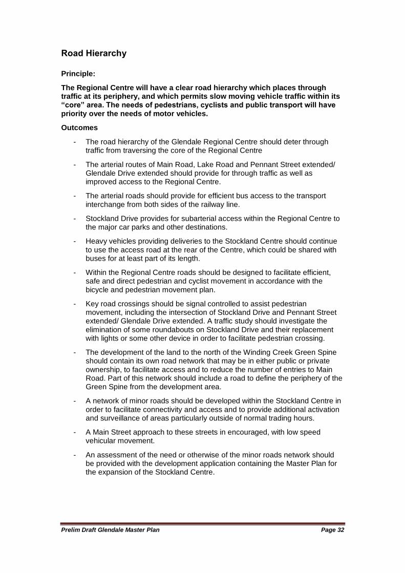
Road Hierarchy
Principle:
The Regional Centre will have a clear road hierarchy which places through traffic at its periphery, and which permits slow moving vehicle traffic within its “core” area. The needs of pedestrians, cyclists and public transport will have priority over the needs of motor vehicles.
Outcomes
- The road hierarchy of the Glendale Regional Centre should deter through traffic from traversing the core of the Regional Centre
- The arterial routes of Main Road, Lake Road and Pennant Street extended/ Glendale Drive extended should provide for through traffic as well as improved access to the Regional Centre.
- The arterial roads should provide for efficient bus access to the transport interchange from both sides of the railway line.
- Stockland Drive provides for subarterial access within the Regional Centre to the major car parks and other destinations.
- Heavy vehicles providing deliveries to the Stockland Centre should continue to use the access road at the rear of the Centre, which could be shared with buses for at least part of its length.
- Within the Regional Centre roads should be designed to facilitate efficient, safe and direct pedestrian and cyclist movement in accordance with the bicycle and pedestrian movement plan.
- Key road crossings should be signal controlled to assist pedestrian movement, including the intersection of Stockland Drive and Pennant Street extended/ Glendale Drive extended. A traffic study should investigate the elimination of some roundabouts on Stockland Drive and their replacement with lights or some other device in order to facilitate pedestrian crossing.
- The development of the land to the north of the Winding Creek Green Spine should contain its own road network that may be in either public or private ownership, to facilitate access and to reduce the number of entries to Main Road. Part of this network should include a road to define the periphery of the Green Spine from the development area.
- A network of minor roads should be developed within the Stockland Centre in order to facilitate connectivity and access and to provide additional activation and surveillance of areas particularly outside of normal trading hours.
- A Main Street approach to these streets in encouraged, with low speed vehicular movement.
- An assessment of the need or otherwise of the minor roads network should be provided with the development application containing the Master Plan for the expansion of the Stockland Centre.
Prelim Draft Glendale Master Plan Page 33
Figure 5- Road Hierarchy
Prelim Draft Glendale Master Plan Page 34
Parking
Principle:
As much as possible, car parking will be provided in centralised carparks shared by a range of users and uses.
Outcomes
- Car parking shall be provided consistent with the requirements of the Lake Macquarie Development Control Plan No.1 (DCP).
- An under provision of car parking below that required by the DCP is permissible provided that it is justified to Council‘s satisfaction by reference to the land use and the nature of the development being proposing and any associated initiatives to improve or support public transport usage.
- Centralised car parking which achieves efficiencies in the provision of shared car parking is encouraged, particularly in relation to the Transport Interchange and Stockland Centre.
- Access to major car parks should be off arterial or subarterial roads only in order to reduce vehicular volumes within other areas of the Regional Centre.
- A limited number of large car parks located centrally and at the periphery of the ―Town Centre‖ is encouraged.
- Commuter car parking in conjunction with the Transport Interchange should be accessible for extended hours, preferably 24 hours each day, and be provided with monitored security.
- At grade ground level car parking is generally discouraged in the core of the Regional Centre. It is an inefficient use of land, is generally aesthetically unpleasing and undermines the objective to maximise activity in the Regional Centre.
Prelim Draft Glendale Master Plan Page 35
Public Places and Spaces (Public Realm)
Principle:
Public realm of the Regional Centre will have a unique character reflective of its role as the civic and community focus of Lake Macquarie. It will be accessible to all.
Outcome
- The public realm within the Regional Centre has two major contexts:
Publicly accessible publicly owned spaces, and
Publicly accessible privately owned spaces.
- A Public Areas Access Plan should be prepared to define the use of major or key privately owned public spaces in order to ensure that the general rights of individuals are maintained, and that agreed standards of management and maintenance are met. This is particularly the case with the Stockland Centre because of its role in relation to the Transport Interchange and the pedestrian network.
- A range of public spaces, both open and closed to the open air, should be provided in the Regional Centre, in contrast to many conventional regional shopping centres.
- The Glendale Regional Centre should have a public realm which is inviting to all, stimulating, accessible and safe.
- Buildings are to be designed with their contribution to the public realm as a major objective.
- Mixed use should assist in the activation of the public realm, and should necessitate the design of public realm to cater for a variety of different user needs.
- The public realm should also be unique and reflective of the experiences and culture of the local community and guided by a Public Domain Design Strategy.
- Town art should play a significant role in expressing these characteristics in a physical form and one that is relevant to its context and setting.
- The appearance of the streetscape of the arterial road network should be governed by urban design and streetscape guidelines.
- The public realm of the approaches to the Regional Centre is unique and reflective of the environmental qualities being sought within the Regional Centre. Large canopy trees providing a boulevarde effect are a preferred street tree treatment.
- The treatment of the public realm should range from the relaxed natural environmental qualities of the Winding Creek Green Spine to the intensive urban character of the areas surrounding the Transport Interchange.
- The treatment of the public realm must respond to the urban structure objectives for that specific locality within the Regional Centre. Each area should have a thematic approach, building on an overall suite of streetscape and public realm guidelines for the Regional Centre.
Prelim Draft Glendale Master Plan Page 36
Open Space system
Principle:
The Regional Centre will have an open space system that includes well linked natural, built, formal and informal settings to meet environmental and recreational needs.
Outcomes:
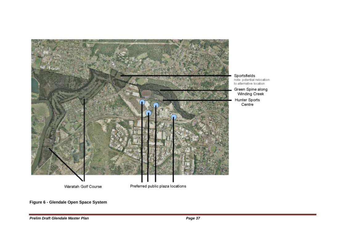
- The major element of the open space system (see figure below) of the
Glendale Regional Centre is the Winding Creek Corridor.
- This Winding Creek Corridor ―green spine‖ should provide an informal area of open space whose primary aim is environmental restoration, water management and the provision of informal recreational space. It should contain walking trails, places of quiet contemplation and a picnic area.
- An environmental management and rehabilitation plan should be developed for Winding Creek
- Linkages from the Winding Creek to the waterway and open space system upstream and downstream should be investigated and enhanced.
- The Hunter Sports Center, and the William Bower sporting fields and parkland to the west of Lake Road should provide a range of active recreational open spaces.
- There may be the potential to develop new active open space to the south of Main Road (east), and to link this to the Hunter Sports Centre in some way.
- The pedestrian and bicycle network should link open spaces with each other and to the public spaces (plazas) within the more intensive urban components of the Regional Centre.
- A pedestrian and bicycle route should link the Regional Centre to the large area of informal open space on Munibung Hill.
- A bicycle route should also link the Regional Centre to the Warners Bay and Five Islands Cycleway system, providing access to lakeside recreational spaces including Speers Point Park.
- The open space network should undergo further investigation, including
The creation of a linked series of spaces from Winding Creek to the Edgeworth Playing Fields in the west, to Speers Point Park in the south, and across Winding Creek to the proposed sporting fields and lands at Teralba
the function and need for the park to the southwest of the Stockland Centre, including options for an improved relationship with, and access to, the adjacent residential area and the Regional Centre
The desirability of the location of the William Bower Fields, adjacent to the Crossroads, including the alternative locations that may be better from a locational and functional viewpoint.
Prelim Draft Glendale Master Plan Page 37
Figure 6 - Glendale Open Space System
Prelim Draft Glendale Master Plan Page 38
Housing
Principle:
A range of housing types will be provided with a view to achieving sufficient housing intensity to support a vibrant Regional Centre and an efficient public transport system.
Outcomes:
- The Glendale Regional Centre should have a considerable number of dwellings within the core of the Regional Centre and its context corridors (Lake Road and Main Road).
- Housing development is to comply with the Lake Macquarie Development Control Plan No.1
- The Regional Centre offers a range of opportunities for housing to be incorporated into mixed use development.
- Integrated into Main Street style development, housing should provide opportunities to enliven an area by occupying space on the second or higher floors of a predominantly retail or commercial building.
- The Transport Interchange should provide an additional attraction for commuters, with ready access to Newcastle or the Central Coast by rail, and many locations within Newcastle and Lake Macquarie by bus.
- The demographics of Lake Macquarie show a high and increasing aged population. Glendale provides a market opportunity for such development, close to shops, services and public transport.
- Within the context corridors of Lake Road and Main Road, there should be considerable scope for multistory residential and mixed use development over the medium term. Single storey lower density redevelopment along these corridors should be discouraged, as it greater reduces the ability of the land to be more intensively developed in a way that is more reflective of the land‘s potential.
Prelim Draft Glendale Master Plan Page 39
Area Plans
Principle:
An integrated approach will be achieved through development being guided by Area Plans for each Precinct or major land holding.
Outcomes:
- No substantial development shall be approved prior to Council endorsement of an Area Plan for the subject Precinct/Major landholding.
- Precinct Area Plans shall provide detailed development guidelines that apply the principles and outcomes expressed in the Regional Centre Master Plan.
- Precinct Area Plans shall be consistent with the Lake Macquarie Development Control Plan except where there is an inconstancy with the Glendale Regional Centre Master plan, in which case the latter shall prevail.
Process
Principle:
A process should be established to manage the implementation of the Master Plan and Area Plans
Outcomes:
- To take a co-ordinated approach to development across the entire Regional Centre
- Ongoing co-ordination across the stakeholders should achieve improved co-ordination and move complementary actions
- Master Plan and Area Plan implementation should be monitored and reviewed
- Opportunities for collective decision making and action should be maximised.
- To provide a process that achieves long term co-ordination and commitment for the innovative development and management of the Regional CentreImproved co-ordination and communication should improve implementation

Prelim Draft Glendale Master Plan Page 40
Prelim Draft Glendale Master Plan Page 41
Preliminary Draft GLENDALE REGIONAL CENTRE MASTER PLAN
BACKGROUND REPORT
Lake Macquarie City Council and Strategy Hunter consultants

Prelim Draft Glendale Master Plan Page 42
Prelim Draft Glendale Master Plan Page 43
Introduction
The Glendale area is significant for Lake Macquarie City and the Lower Hunter. It offers the ability to establish a new transit oriented regional centre commensurate with the aspirations of the City, with a high standard of urban amenity and access to services.
In future, Glendale should become one of the three major centres of the Lake Macquarie Local Government Area the others being Charlestown and Morisset. Glendale has a number of advantages over these Centres in performing the role of the Lake Macquarie ―City Centre‖. Glendale is equally accessible from the eastern and western sides of the Lake. It is less topographically constrained than Charlestown. It is highly accessible by road, yet unlike Charlestown its core is not dissected by a very busy arterial road. Glendale also has the advantage of being the site of a transport interchange for both rail and road based transport. Morisset has many of the attributes of Glendale but is located in a more isolated location relative to the main population centre of Lake Macquarie. Glendale is also very accessible to the adjacent Local Government Areas of Wyong, Cessnock, Maitland, Newcastle and Port Stephens because of its ready access to the Freeway.
The new Glendale Regional Centre provides an opportunity to create vibrant civic and community spaces which provide a focus for, and which reflect, the culture and lifestyle of the Lake Macquarie community; and its early stage of development provides a strategic opportunity to apply techniques to reduce significantly resource consumption and to manage the ecological footprint of the Centre.
Lake Macquarie City Council engaged Strategy Hunter consultants to work with the Council in developing a Master Plan for the Glendale Regional Centre. The Master Plan refines and builds on the draft Urban Structure Plan for Glendale Cardiff produced by Dickson Rothschild consultants in 2004, by incorporating additional investigations and the direction of the 2006 Lower Hunter Regional Strategy. The Master Plan process has received funding assistance from the NSW Department of Planning‘s Planning Reform Program.
Objectives of this Project:
The objectives of this project are to:
To produce a Master Plan for Lake Macquarie‘s emerging regional centre
To identify social ,economic and environmental outcomes for the new regional centre
To facilitate implementation through a co-operative process with stakeholders
Objectives for Glendale
To provide a focus for the City of Lake Macquarie
To be a leading regional centre in urban design, environmental sustainability and community use.
Prelim Draft Glendale Master Plan Page 44
To provide a mix of higher level services, recreation and leisure, employment, civic and cultural services, and housing, befitting of a regional centre
To provide civic and public spaces for a range of regional, city level, neighbourhood and personal activities
To be highly accessible by all modes of transport, with special consideration being given for public transport, walking and cycling, and people with mobility disabilities
To be unique and memorable and identifiable as part of Lake Macquarie.
The Role of the Master Plan and Background Report
The Glendale Master Plan has two parts, a Background Paper and the Master Plan itself.
The Background Paper summarises the main planning issues and opportunities facing the Glendale Centre.
The Master Plan states a series of principles for the development of Glendale and identifies outcomes to be achieved. These parameters should shape the detailed planning of the Glendale Regional Centre and its surrounds, in the form of Precinct Area Plans.
Prelim Draft Glendale Master Plan Page 45
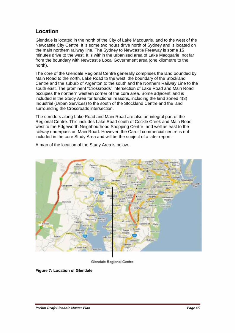
Location
Glendale is located in the north of the City of Lake Macquarie, and to the west of the Newcastle City Centre. It is some two hours drive north of Sydney and is located on the main northern railway line. The Sydney to Newcastle Freeway is some 15 minutes drive to the west. It is within the urbanised area of Lake Macquarie, not far from the boundary with Newcastle Local Government area (one kilometre to the north).
The core of the Glendale Regional Centre generally comprises the land bounded by Main Road to the north, Lake Road to the west, the boundary of the Stockland Centre and the suburb of Argenton to the south and the Northern Railway Line to the south east. The prominent ―Crossroads‖ intersection of Lake Road and Main Road occupies the northern western corner of the core area. Some adjacent land is included in the Study Area for functional reasons, including the land zoned 4(3) Industrial (Urban Services) to the south of the Stockland Centre and the land surrounding the Crossroads intersection.
The corridors along Lake Road and Main Road are also an integral part of the Regional Centre. This includes Lake Road south of Cockle Creek and Main Road west to the Edgeworth Neighbourhood Shopping Centre, and well as east to the railway underpass on Main Road. However, the Cardiff commercial centre is not included in the core Study Area and will be the subject of a later report.
A map of the location of the Study Area is below.
Figure 7: Location of Glendale
Prelim Draft Glendale Master Plan Page 46
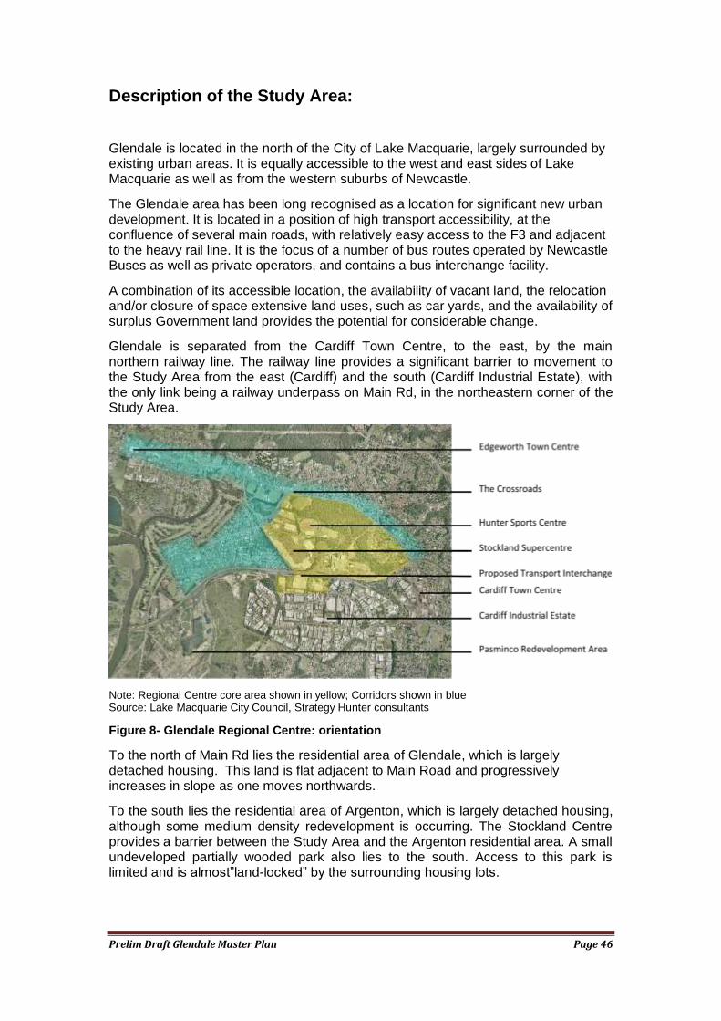
Description of the Study Area:
Glendale is located in the north of the City of Lake Macquarie, largely surrounded by existing urban areas. It is equally accessible to the west and east sides of Lake Macquarie as well as from the western suburbs of Newcastle.
The Glendale area has been long recognised as a location for significant new urban development. It is located in a position of high transport accessibility, at the confluence of several main roads, with relatively easy access to the F3 and adjacent to the heavy rail line. It is the focus of a number of bus routes operated by Newcastle Buses as well as private operators, and contains a bus interchange facility.
A combination of its accessible location, the availability of vacant land, the relocation and/or closure of space extensive land uses, such as car yards, and the availability of surplus Government land provides the potential for considerable change.
Glendale is separated from the Cardiff Town Centre, to the east, by the main northern railway line. The railway line provides a significant barrier to movement to the Study Area from the east (Cardiff) and the south (Cardiff Industrial Estate), with the only link being a railway underpass on Main Rd, in the northeastern corner of the Study Area.
Note: Regional Centre core area shown in yellow; Corridors shown in blue Source: Lake Macquarie City Council, Strategy Hunter consultants
Figure 8- Glendale Regional Centre: orientation
To the north of Main Rd lies the residential area of Glendale, which is largely detached housing. This land is flat adjacent to Main Road and progressively increases in slope as one moves northwards.
To the south lies the residential area of Argenton, which is largely detached housing, although some medium density redevelopment is occurring. The Stockland Centre provides a barrier between the Study Area and the Argenton residential area. A small undeveloped partially wooded park also lies to the south. Access to this park is limited and is almost‖land-locked‖ by the surrounding housing lots.
Prelim Draft Glendale Master Plan Page 47
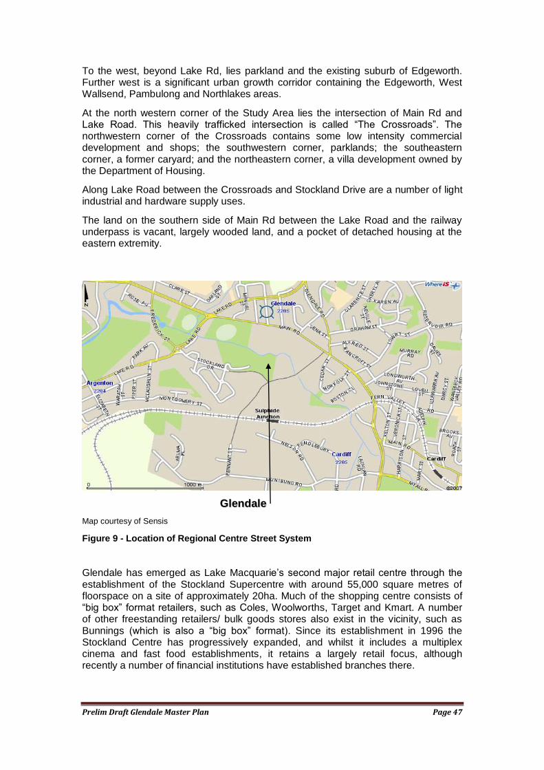
To the west, beyond Lake Rd, lies parkland and the existing suburb of Edgeworth. Further west is a significant urban growth corridor containing the Edgeworth, West Wallsend, Pambulong and Northlakes areas.
At the north western corner of the Study Area lies the intersection of Main Rd and Lake Road. This heavily trafficked intersection is called ―The Crossroads‖. The northwestern corner of the Crossroads contains some low intensity commercial development and shops; the southwestern corner, parklands; the southeastern corner, a former caryard; and the northeastern corner, a villa development owned by the Department of Housing.
Along Lake Road between the Crossroads and Stockland Drive are a number of light industrial and hardware supply uses.
The land on the southern side of Main Rd between the Lake Road and the railway underpass is vacant, largely wooded land, and a pocket of detached housing at the eastern extremity.
Map courtesy of Sensis
Figure 9 - Location of Regional Centre Street System
Glendale has emerged as Lake Macquarie‘s second major retail centre through the establishment of the Stockland Supercentre with around 55,000 square metres of floorspace on a site of approximately 20ha. Much of the shopping centre consists of ―big box‖ format retailers, such as Coles, Woolworths, Target and Kmart. A number of other freestanding retailers/ bulk goods stores also exist in the vicinity, such as Bunnings (which is also a ―big box‖ format). Since its establishment in 1996 the Stockland Centre has progressively expanded, and whilst it includes a multiplex cinema and fast food establishments, it retains a largely retail focus, although recently a number of financial institutions have established branches there.
GGlleennddaallee
Prelim Draft Glendale Master Plan Page 48
The Cardiff Commercial Centre lies to the east of the railway line. It contains some 7000 square metres of generally lower grade retail and commercial space, together with a range of other uses including several car yards, three licenced clubs and sporting fields on its periphery. Two new supermarket proposals are under consideration for Cardiff (Woolworths and Aldi), to supplement the existing BiLo Supermarket
The Glendale Study Area contains the Hunter Sport Centre. It contains facilities for several thousand spectators, an Athletics Centre with a 9-lane Olympic running track with provision for a complete range of field events and an Olympic standard indoor Gymnastics Centre. The Centre has potential for expansion, as discussed later. A 42 place child care centre is also located on site.
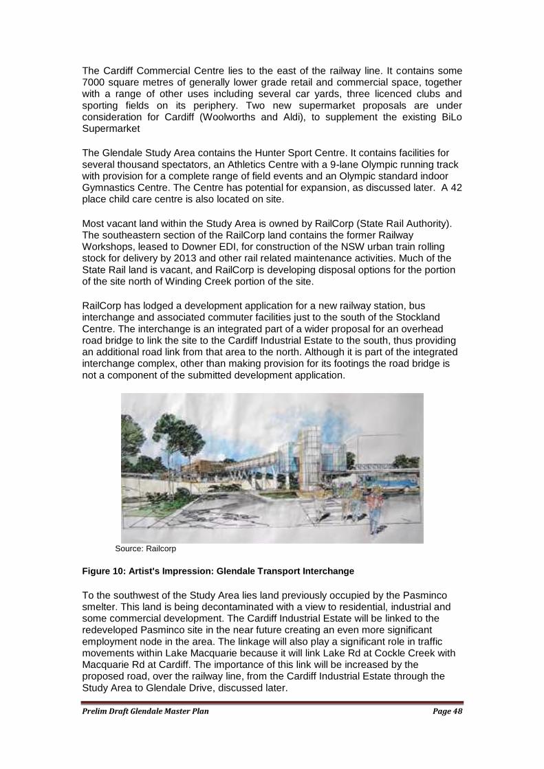
Most vacant land within the Study Area is owned by RailCorp (State Rail Authority). The southeastern section of the RailCorp land contains the former Railway Workshops, leased to Downer EDI, for construction of the NSW urban train rolling stock for delivery by 2013 and other rail related maintenance activities. Much of the State Rail land is vacant, and RailCorp is developing disposal options for the portion of the site north of Winding Creek portion of the site.
RailCorp has lodged a development application for a new railway station, bus interchange and associated commuter facilities just to the south of the Stockland Centre. The interchange is an integrated part of a wider proposal for an overhead road bridge to link the site to the Cardiff Industrial Estate to the south, thus providing an additional road link from that area to the north. Although it is part of the integrated interchange complex, other than making provision for its footings the road bridge is not a component of the submitted development application.
Source: Railcorp
Figure 10: Artist's Impression: Glendale Transport Interchange
To the southwest of the Study Area lies land previously occupied by the Pasminco smelter. This land is being decontaminated with a view to residential, industrial and some commercial development. The Cardiff Industrial Estate will be linked to the redeveloped Pasminco site in the near future creating an even more significant employment node in the area. The linkage will also play a significant role in traffic movements within Lake Macquarie because it will link Lake Rd at Cockle Creek with Macquarie Rd at Cardiff. The importance of this link will be increased by the proposed road, over the railway line, from the Cardiff Industrial Estate through the Study Area to Glendale Drive, discussed later.
Prelim Draft Glendale Master Plan Page 49
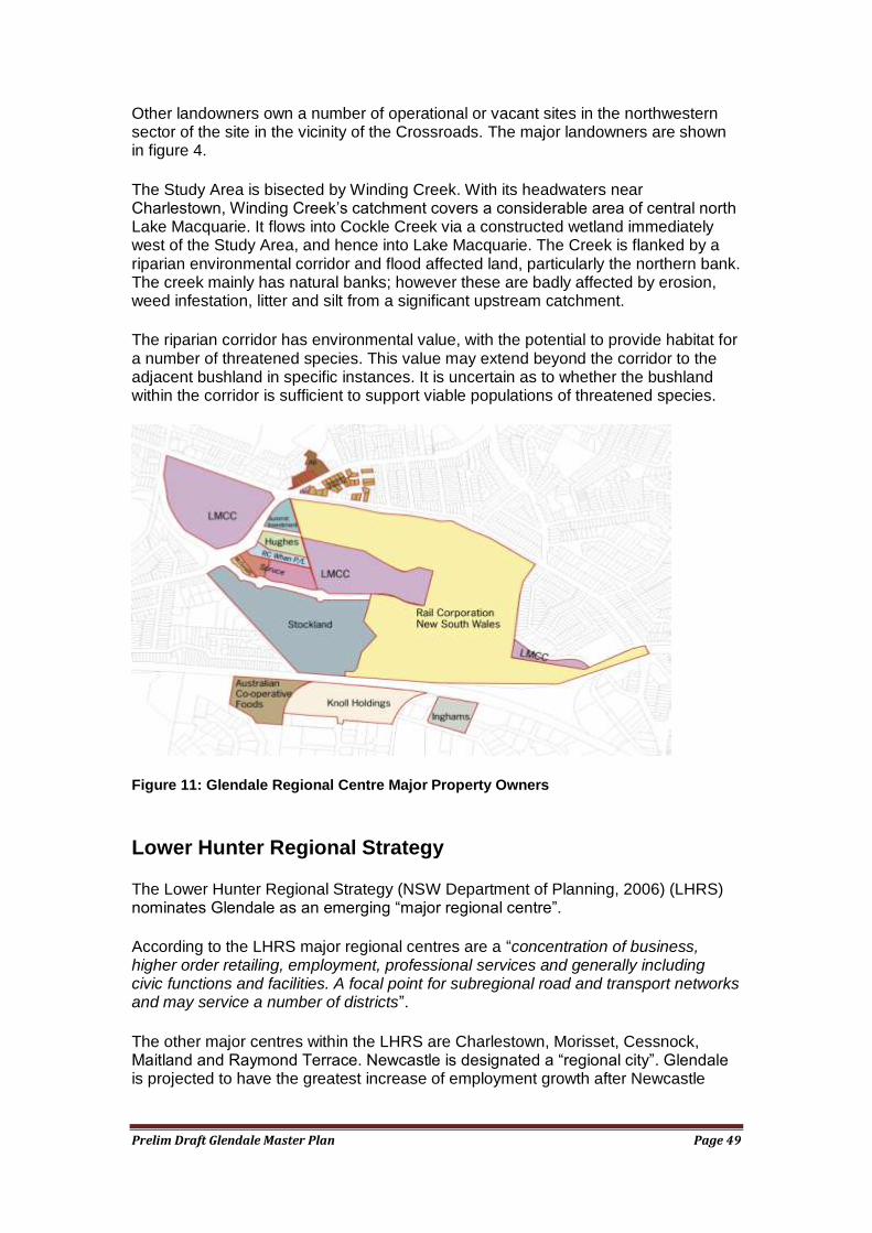
Other landowners own a number of operational or vacant sites in the northwestern sector of the site in the vicinity of the Crossroads. The major landowners are shown in figure 4.
The Study Area is bisected by Winding Creek. With its headwaters near Charlestown, Winding Creek‘s catchment covers a considerable area of central north Lake Macquarie. It flows into Cockle Creek via a constructed wetland immediately west of the Study Area, and hence into Lake Macquarie. The Creek is flanked by a riparian environmental corridor and flood affected land, particularly the northern bank. The creek mainly has natural banks; however these are badly affected by erosion, weed infestation, litter and silt from a significant upstream catchment.
The riparian corridor has environmental value, with the potential to provide habitat for a number of threatened species. This value may extend beyond the corridor to the adjacent bushland in specific instances. It is uncertain as to whether the bushland within the corridor is sufficient to support viable populations of threatened species.
Figure 11: Glendale Regional Centre Major Property Owners
Lower Hunter Regional Strategy
The Lower Hunter Regional Strategy (NSW Department of Planning, 2006) (LHRS) nominates Glendale as an emerging ―major regional centre‖.
According to the LHRS major regional centres are a ―concentration of business, higher order retailing, employment, professional services and generally including civic functions and facilities. A focal point for subregional road and transport networks and may service a number of districts‖.
The other major centres within the LHRS are Charlestown, Morisset, Cessnock, Maitland and Raymond Terrace. Newcastle is designated a ―regional city‖. Glendale is projected to have the greatest increase of employment growth after Newcastle
Prelim Draft Glendale Master Plan Page 50
City, and given the Cardiff employment node adjacent, Glendale and its surrounds may be the largest single employment node in the Lower Hunter.
The LHRS projects an additional 6200 jobs and 4000 dwellings in the Glendale Cardiff regional centre by 2031.
Additionally, Main Road from Glendale to Edgeworth is designated a renewal corridor. The LHRS describes renewal corridor as “presenting opportunities for economic renewal and/or housing renewal and intensification‖. It goes on to state that ―a strategic approach to the issue of mine subsidence allows increased development potentials in major centres such as Glendale and Cardiff to be achieved.
Glendale is clearly identified to become one of the most significant centres in the Lower Hunter.
Lifestyle 2020
Council‘s Lifestyle 2020 also nominates Glendale as a sub regional centre, with a similar functional role to that stated in the LHRS.
Lifestyle 2020 also identifies Glendale as a location for a new railway station and transport interchange. Lifestyle 2020 has a strong policy orientation towards focusing activities at mixed use centres to increase the City‘s reliance on public transport and non motor vehicle transport. Glendale‘s central, highly accessible location within the City, and its potential for further development, gives it an important role in delivering this policy objective.
The Lifestyle 2020 process identified that significant change was likely to occur in Glendale and Cardiff. Consequently Council engaged Dickson Rothschild to produce a draft Urban Structure Plan for the area in 2004. This draft provides a background and some options for future directions.
The Draft Structure Plan for Glendale/Cardiff
The draft Structure Plan for Glendale/Cardiff was produced by Dickson Rothchild for Lake Macquarie City Council in 2004. The draft Structure plan reviews a range of planning considerations for the site and recommends Urban Structure Plans for both Glendale and Cardiff. Precinct Plans are also recommended for both centres. The Structure Plan for Glendale is based on a core riparian restoration corridor along Winding Creek, with the surrounding urban structure generally configured on modified new urbanism principles. The Master Plan exercise has sought to build on the draft Structure Plan in a number of ways, by:
seeking to resolve the issue of mine subsidence that significantly affects the site, but which was not considered in the draft Structure plan
incorporating a number of redevelopment corridors along Main Road and Lake Road which are essential complements to the ―core‖ of the Glendale Regional Centre
incorporating all corners of the Cross Roads (intersection of Main Road and Lake Road) in the Master Plan
Prelim Draft Glendale Master Plan Page 51
undertaking an assessment of the ability of property market to support higher intensity development of various types within the Master Plan and context area
considering the impact of more recent concept planning of the Pasminco site into the Master Plan
seeking to achieve greater integration of the transport interchange into the Master Plan
seeking to discuss in further detail public spaces, as well as civic and community functions within the Master Plan area.
assuming the former Railway Workshops site will be used for industrial purposes for some time (i.e. no detailed planning has been done), but ensuring integration with the balance of the Master Plan area, can be achieved over time should the land use change.
The Master Plan also has adopted a less detailed approach than the draft Structure Plan, focusing on development principles, general land use allocations and recommended development intensity, rather than showing a detailed street layout (which in any case was indicative).
Lake Macquarie Local Environmental Plan - Land Use Zoning
The Lake Macquarie Local Environmental Plan (2004) establishes the land use zones that apply throughout the City, and allocates zones to land parcels.
The Study area is generally zoned 3(1) Urban Centre (Core) including the Stockland Centre and the vicinity of the former Railway Workshops, a linear band of land zoned 3(2) Urban Centre (Support) runs along the southern side of Main Road from the Railway underpass to Lake Road, the riparian and conservation lands surrounding Winding Creek are zoned 7(2) Conservation (Secondary), whilst the former car yard and industrial/hardware retailing uses on the eastern side Lake Road south of the Crossroads are zoned 4(2) Industrial (General). The southern side of the railway line, is zoned 4(3) Industrial (Urban Services) adjacent to Pennant Street extended, and the balance zone 4(2) Industrial (General), under the Lake Macquarie Local Environmental Plan 2004. Details are shown on the map below.
The proposed extensions of Pennant Street and of Stockland Drive are zoned 5 Infrastructure.
The Study Area abuts the existing relatively low density residential areas of Argenton to the south and Glendale to the north. These areas contain both 2(1) Residential and 2(2) Residential (Urban Living) zones.
The Cardiff Commercial Centre is zoned 3(1) Urban Centre (Core) and is surrounded by a substantial area of land zoned 3(2) Urban Centre (Support) with land zoned 2(2) Residential (Urban Living) adjacent.
The small strip shopping centre on the northwestern corner of the Crossroads is zoned 3(1) Urban Centre.
The land use tables for these zones, showing zone objectives, permissible and prohibited uses, can be found in Appendix 1.
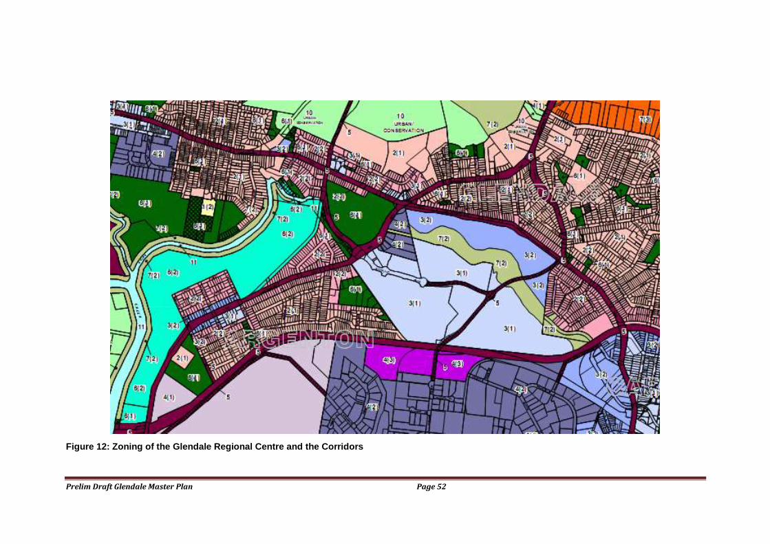
Prelim Draft Glendale Master Plan Page 52
Figure 12: Zoning of the Glendale Regional Centre and the Corridors
Prelim Draft Glendale Master Plan Page 53
Physical Infrastructure
Reticulated water, gas, electricity and sewerage services are available to the Study Area. Landline telephone services are available, as is broadband internet to at least ADSL 2+ standards, from several providers. Several mobile telephone providers provide coverage to the area.
The Study Area is highly accessible by road, although some parts of the road system are experiencing capacity constraints (see later). There is no direct access by road to the Cardiff industrial Area to the south, and the provision of this access is a component of the Transport Interchange proposal (see later).
The Study Area is on the main northern railway line. The line is served by a significant number of passenger trains travelling to the north and south. The site does not yet have a railway station. The former railway workshops have spur access to the railway line for industrial purposes, and sites within the Zone 4(3) have previously had spur access to the railway line for industrial purposes.
Community Services
Glendale lacks a number of the major community service delivery points that could be expected in a Regional Centre.
Medicare
The nearest Medicare office is in Wallsend, with an agency in Boolaroo.
Centrelink
The nearest Centrelink offices are at Wallsend, Charlestown and Toronto.
Health
The closest general hospital with an outpatients and casualty services is the John Hunter Hospital at Rankin Park. The closest Community Health Services are at Newcastle, Wallsend and Toronto.
A General Practice clinic is located at the Stockland Centre, with others at Cardiff and Boolaroo.
Child Care
A 42 place child care centre is located on the site of the Hunter Sports Centre. It is owned by Lake Macquarie City Council and leased to a community based non profit organisation to operate. It offers long day care to children for 6 weeks to school age. A number of other commercial and community based child care centres and preschools exist in the vicinity. Additionally, the Lake Macquarie Family Day Care Service provides home based child care to the locality.
Increasing resident, worker and visitor numbers will create a demand for additional child care provision, and for a greater diversity of child care services, such as occasional care. The improved and direct road transport link to the Cardiff Industrial Area will potentially create an increased demand for child care services in Glendale, from workers in the Industrial Area.
Youth
Council‘s Section 94 Plan makes provision for a youth facility, suggesting that it be located adjacent, if possible, to the athletic track at Glendale. This will provide

Prelim Draft Glendale Master Plan Page 54
opportunities for Northlake youth workers to provide outdoors recreational and sporting programs, as well as the usual indoor activities. An office and interview area is also required for the North Lakes Adolescent & Family Counselling Service.
Due to the availability of public transport, including the proposed rail service, to Glendale, and the nearby Shopping Centre and Movie Theatre complex, this location will be highly accessible to youth. As the Glendale Regional Centre develops further, the area will become progressively more attractive as a youth destination, leading to the requirement for youth facilities which cater for a subregional catchment.
Community Centre
Community Halls and Centres can be found at Edgeworth, Boolaroo, Cardiff, and Argenton. These Centres are designed to provide facilities for the immediate local population. The development of the Glendale Regional Centre provides an opportunity to provide a community centre offering a wider range of facilities and spaces to a local and subregional catchment. The demand for this facility will be created by residents, workers and visitors to the Regional Centre.
Council‘s Section 94 Plan makes provision for a multipurpose Youth and Community
Centre incorporating a general-purpose community activity area, disability services area and youth section.
Council‘s Community Facilities and Services Policy states a preference for ―multipurpose centres that offer a wide range of services and peer support for workers, rather than accommodating services in individual premises‖. Therefore the planning of community facilities in Glendale should be consistent with this policy position.
A facility planning issue is the relationship of a subregional multipurpose centre to the Hunter Sports Centre. There will be many spaces in the Hunter Sports Centre which could be shared with a multipurpose community centre and the feasibility of this, including management options deserves further investigation.
Library
It is proposed to construct a new District (Area) library at Glendale to replace the Speers Point Library that may either become a District (Branch) library, or be demolished. Both Cardiff and Edgeworth Libraries may be replaced, due to site restrictions that do not allow for expansion.
The high transport accessibility of Glendale makes it a very attractive location for a District Library.
Libraries are evolving in order to meet a changing community preferences and as a result of technological change, particularly information technology and the internet. New library service delivery models recognise the potential for libraries to perform wider community facility functions, such as the provision of meeting spaces and cultural activities. Accordingly, the potential for the district library to play an integrated role within a wider ―community facilities‖ hub should form part of the development of the community services delivery strategy for the Glendale Centre. This would also be consistent with Council‘s Community Facilities and Services Policy. A review of Council‘s Library Services Delivery Model is due to commence in 2008 and would consider this issue.
Section 94 for Community Facilities
Council‘s existing Section 94 Plan does not make provision for Section 94 contributions from commercial development within the Glendale Regional Centre.
Prelim Draft Glendale Master Plan Page 55
Given the sizeable number of people likely to be working within, or visiting, the Regional Centre, and the demand they will create for community services, such as child care, it is reasonable to consider a requirement for contributions towards community services and other infrastructure from commercial development in the vicinity. The Section 94 provisions for Glendale also need to be reviewed in view of the likelihood of multipurpose and district level facilities in the Centre, and the revised population targets for the area contained within the Lower Hunter Regional Strategy and associated documents.
Education
Public primary schools are located at Glendale East, Edgeworth and Argenton. The nearest public high school is Glendale Technology High. The Holy Cross Catholic primary school is located at Glendale. The nearest Catholic High Schools are St Paul‘s at Booragul and St Pius at Kotara. A Community Christian School, Macquarie College at Elermore Vale offers preschool through to Year 12 schooling.
The nearest TAFE facilities are at Glendale (limited courses) and Newcastle. The nearest University is Newcastle University at Callaghan.
The educational institutions in the vicinity are likely to use the services available in the Regional Centre, such as the Sport Centre, multipurpose community centre, library and public transport. An efficient and safe pedestrian movement system between the educational institutions and the Regional Centre is required to facilitate their access and use.
Emergency Services
The Study Area is served by a range of emergency service locations in close proximity for each service type.
Fire
Several fire stations are in close proximity. They include Cardiff, Boolaroo and Wallsend.
Police.
The closest police stations are at Cardiff, Boolaroo and Wallsend. Glendale is within the Lake Macquarie Local Area Command.
Ambulance.
The closest ambulance stations are at Boolaroo and Cardiff.
Mine Subsidence
The extent of mine subsidence issues need to be determined as this will affect the development potential of the site. Possible recent longwall mining may also have affected ground levels, and consequently the flood regime. This section describes subsidence issues for the Glendale Regional Centre and the context corridors. It largely reflects advice found in geotechnical studies of the land and advice from the Mine Subsidence Board.
The Glendale Regional Centre is significantly affected by mine subsidence constraints (see figure below)). Much of the site has had 2.1m of extraction at 90 metres depth. It was recently mined by the now abandoned New Wallsend No .2 (Gretley) Colliery in the 1990‘s using the mini wall method. A portion of the Study
Prelim Draft Glendale Master Plan Page 56
Area adjacent to the railway line has not been mined, but is subject to a mining lease (Teralba Colliery). It is not known if the lease will ever be mined, as Teralba Colliery is under care and maintenance, and may never return to production (particularly the periphery of the lease area). The Study Area is on the periphery of the lease.
The abandoned mine workings are not flooded due to water being pumped from the Teralba Colliery workings (the pump is located on Waratah Golf Club site). If the pumping ceased the workings would gradually fill with water, probably taking 10-20 years. As the workings flooded there would be an initial period of potential instability as the water ―lubricated‖ some less stable strata. Once the working had filled, the pressure of the water would probably increase the stability of the area.
The mined areas of the site have generally experienced subsidence of around 20-30mm. In some areas an additional 20-30mm of subsidence has occurred due to caving above individual mini wall panels. In one area subsidence of up to 277 mm has occurred, probably due to the effects of thrust faults on localised pillar failure. Should additional localised pillar failure occur, significant subsidence of up to 300 mm is likely. Whilst the subsidence which has occurred is within the expected parameters, the potential for additional subsidence exists, and the Mine Subsidence Board (MSB) considers this risk in determining the permissible development intensity for specific site and redevelopment proposals.
Within the Glendale Regional Centre core study area, the Stockland Centre site and adjacent land is largely undermined by miniwall panels. Structures would be considered individually depending on size, flexibility, design for possible future subsidence, and so on. Similar structures to that existing are unlikely to be a concern subject to geotechnical assessment of the mine workings and design for any potential mine subsidence. Further geotechnical and design assessment would be required before buildings of three storeys could be considered.
The southern portion of the Stockland Centre adjacent to and parallel to the railway line is not undermined, however it would be partly affected by the 35 degree angle of draw from the mine workings in the north. This portion of the Stockland site is adjacent to the transport interchange and offers the potential to intensify the development with multistorey buildings to take advantage of the access to public transport.
The former railway workshops site is similarly affected to the Stockland Centre.
The Hunter Sports Centre site is also undermined by miniwall panels. Structures would be considered individually depending on size, flexibility, design for possible future subsidence, etc. Similar structures to that existing are unlikely to be a concern subject to geotechnical assessment of the mine workings and design for any potential mine subsidence.
Along Main Rd east of Lake Road development is likely to be limited to two to three storeys. This area along Main Road is undermined by miniwall panels. An issue for the Board on this site include the risk of mine subsidence and areas with geological disturbances such as faulting and dykes. Current surface development guidelines provide for one 2 storey brick veneer structure per existing lot. Subject to geotechnical assessment a range of structures may be possible but three to four storey ‗office park‘ structures may be too intensive. This may not be an issue as many office park buildings are 2-3 storeys. Given the risk of mine subsidence it is unlikely residential structures of three to four storeys would receive mine subsidence approval.
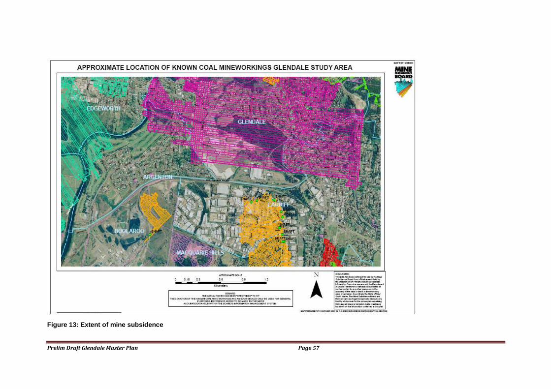
Prelim Draft Glendale Master Plan Page 57
Figure 13: Extent of mine subsidence

Prelim Draft Glendale Master Plan Page 58
Intensive commercial development may be more likely to be approved than intensive residential development because of the nature of commercial buildings‘ construction. The latter having larger internal spaces and not as many rigid, partitions. An office park development of well spaced relatively small footprint buildings may be quite suited to this site. However each development would require an individual risk assessment.
The sites immediately adjacent to the intersection of Lake and Main Roads (―the Crossroads‖) comprise an important gateway to the Glendale Regional Centre. Indeed, some of the more symbolically significant buildings within the Regional Centre might be appropriately located on one of these highly visible corners.
These corner sites provide an urban design opportunity for relatively intensive development, stepping up to the corner. However, they are relatively constrained by mine subsidence. The sites are undermined by miniwall panels with varying tilt and strain implications should subsidence occur. Detailed geotechnical assessment would be required for any surface development of small footprint structures of greater than 2-3 storeys. It is unlikely developments of five to six storeys would be approved without specific geotechnical assessment.
The open space area on the southwestern corner of the Crossroads intersection is undermined by first workings or within the zone of influence of secondary extraction. Whether five to six storey development is suitable on part of this area would need to be determined through detailed geotechnical evaluation. Some larger structures, of relatively small footprint may be acceptable.
Along Main Road west of the Lake Road, three to four storey development may be possible in areas outside the 35° angle of draw from the mine workings as these areas are not within the zone of influence of mining.
There is one area containing main underground mine roadways at the western end of this Corridor closer to the Edgeworth Town Centre where three to four storey medium residential development would be given consideration subject to geotechnical assessment.
The remaining areas are generally within the zone of influence of partial pillar extraction, mini-wall extraction and minimum sized pillars. These areas require detailed geotechnical investigation. Three to four storey medium residential structures would not be considered in areas where there was a risk of future mine subsidence; unless the structure could be designed so as not to be damaged should such an event occur.
The Lake Road Corridor and Argenton, south of the Crossroads is relatively unaffected by mine subsidence because it has not been undermined. Therefore, the ―planning potential‖ is unconstrained by mine subsidence issues. The ―planning potential‖ of the land should be safeguarded and strategies put in place to ensure that development intensity is maximised within the bounds of quality urban design and the maintenance of high amenity.
There may be opportunities for more intensive development in the area to the south of the Study Area including Argenton and the former Pasminco site, because of the nature of mining under these sites, or because they have not been mined. However, many of these areas are subject to a Mining Lease whose potential is likely to be protected by restrictions to surface development so a relatively area specific approach needs to be taken. For example, it is understood that the land between Main Road Boolaroo and TC Fifth Avenue is relatively unconstrained because it is unlikely that mining will taken place. This deserves further investigation and
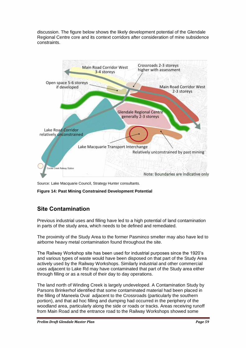
Prelim Draft Glendale Master Plan Page 59
discussion. The figure below shows the likely development potential of the Glendale Regional Centre core and its context corridors after consideration of mine subsidence constraints.
Source: Lake Macquarie Council, Strategy Hunter consultants.
Figure 14: Past Mining Constrained Development Potential
Site Contamination
Previous industrial uses and filling have led to a high potential of land contamination in parts of the study area, which needs to be defined and remediated.
The proximity of the Study Area to the former Pasminco smelter may also have led to airborne heavy metal contamination found throughout the site.
The Railway Workshop site has been used for industrial purposes since the 1920‘s and various types of waste would have been disposed on that part of the Study Area actively used by the Railway Workshops. Similarly industrial and other commercial uses adjacent to Lake Rd may have contaminated that part of the Study area either through filling or as a result of their day to day operations.
The land north of Winding Creek is largely undeveloped. A Contamination Study by Parsons Brinkerhof identified that some contaminated material had been placed in the filling of Maneela Oval adjacent to the Crossroads (particularly the southern portion), and that ad hoc filling and dumping had occurred in the periphery of the woodland area, particularly along the side or roads or tracks. Areas receiving runoff from Main Road and the entrance road to the Railway Workshops showed some
Prelim Draft Glendale Master Plan Page 60
heavy metal and hydrocarbon contamination consistent with those sources. Use of the site for commercial, industrial and residential uses would require remediation works of increasing extent respectively, depending on the proposed end use.
Studies of the 9 ha Northern Settlement Pond and Scald Area to the east of the Hunter Sport Centre site have shown contaminants, such as heavy metals, hydrocarbons and possibly asbestos fibres. This area has received liquid wastes from the industrial activities occurring in the Railway Workshops. Remediation of these areas would require removal of the contaminated material to a land fill and its replacement by clean material. The cost implication of this action is not known.
A Study by Kinhill (1996) of the site of the Hunter Sports Centre found relatively little contamination other than ad hoc localised dumping. However a 13 ha western fill area located immediately to the west of the main Railway Workshop Building and the 10ha eastern fill area located immediately east of the main Railway Workshop Building were both contaminated with several metals.
The sediment and surface waters in the bed of Winding Creek were also found to be contaminated by heavy metals. However, Parsons Brinkerhof (2005) concluded that as these results were relatively uniform as the creek passed through the property, the contamination was unlikely to be due to site activities, but rather airborne pollution from the Pasminco smelter, runoff from high concentrations of these materials in surface soils and urban runoff.
Parts of the site have been subject to contamination studies (such as those referred to above), usually in response to potential development.
Previous contamination studies include:
Site Contamination Assessment and Geotechnical Investigation Railway Maintenance Facility and Adjoining Land Main Road Cardiff NSW, KME, March 1996 SW5078-001 Rev 0).
Supplementary Report, Site Contamination Assessment Proposed Regional Athletics Centre Site within SRA Property, Main Road Cardiff NSW, Kinhill Engineers Pty Ltd, November 1996 SW6000-006-01 Rev 0.
Audit of Environmental Investigation and zoning options of the Former Railway Maintenance Facility and Adjoining Property Cardiff, Longmac Environmental Pty Ltd, September 1997 WRR\963301.
Contamination Assessment Lot 1 DP 1022127 Main Road Glendale (eastern extension of Hunter Sports Centre), RCA Australia, August 2005, 4759-002/0
Proposed Glendale Supercentre extension (Kmart site), Coffey, June 2004, NH9093/01
Combined Preliminary and Detailed Site Investigation (CSI) Glendale Redevelopment Project, Main Rd, Cardiff, Parsons Brinkerhoff, May 2005
The Stockland site is largely developed and it could be expected that any contaminated land has been rehabilitated as part of development.
Prelim Draft Glendale Master Plan Page 61
Generally, the conclusions of the contamination studies is that remediation of contamination of the study area could be undertaken to enable the likely end land uses in an economically viable manner. However, site specific studies would be needed to confirm this for specific future development proposals.
Flooding
An investigation of most of the Study Area was undertaken by Dalland and Lucas in 1996, and a review of this Study by Council staff indicate that its findings are still largely valid, although they are at quite a ―strategic‖ level. The findings have not yet been reviewed in the light of the long weekend 2007 floods or climate change predictions.
The Study by Dalland and Lucas recommended that the creek be retained in a largely natural condition, although some erosion and bank instability should be addressed, and excessive debris likely to cause blockages removed. It did not detail how these banks should be treated. Guidance as to the detailed assessment of the flood hazards present and of the nature of allowable development can be found in the NSW Floodplain Development Manual 2005 (http://www.waterwise.nsw.gov.au/floodplains/manual.shtml). A short length of the creek just upstream of the Lake Rd bridge has engineered banks. The Study identified a 100 year ARI floodway as well as a 100 year ARI flood fringe (see map below). The Study also identified PMF levels at various locations.
The flood fringe area is generally located to the north of the creek (see map) and provides some flood storage capacity during major storm events. However, it does not cause a significant reduction of flood levels downstream of the site. Consequently it could be filled to 500mm above the 100 year ARI without adverse flooding effects (Dallard and Lucas, 1996, 21) (Note: habitat issues also affect this land, see later).
Guidance as to the detailed assessment of the flood hazards present and of the nature of allowable development can be found in the NSW Floodplain Development Manual 2005 (http://www.waterwise.nsw.gov.au/floodplains/manual.shtml).
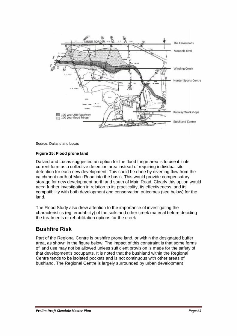
Prelim Draft Glendale Master Plan Page 62
Source: Dalland and Lucas
Figure 15: Flood prone land
Dallard and Lucas suggested an option for the flood fringe area is to use it in its current form as a collective detention area instead of requiring individual site detention for each new development. This could be done by diverting flow from the catchment north of Main Road into the basin. This would provide compensatory storage for new development north and south of Main Road. Clearly this option would need further investigation in relation to its practicality, its effectiveness, and its compatibility with both development and conservation outcomes (see below) for the land.
The Flood Study also drew attention to the importance of investigating the characteristics (eg. erodability) of the soils and other creek material before deciding the treatments or rehabilitation options for the creek
Bushfire Risk
Part of the Regional Centre is bushfire prone land, or within the designated buffer area, as shown in the figure below. The impact of this constraint is that some forms of land use may not be allowed unless sufficient provision is made for the safety of that development's occupants. It is noted that the bushland within the Regional Centre tends to be isolated pockets and is not continuous with other areas of bushland. The Regional Centre is largely surrounded by urban development
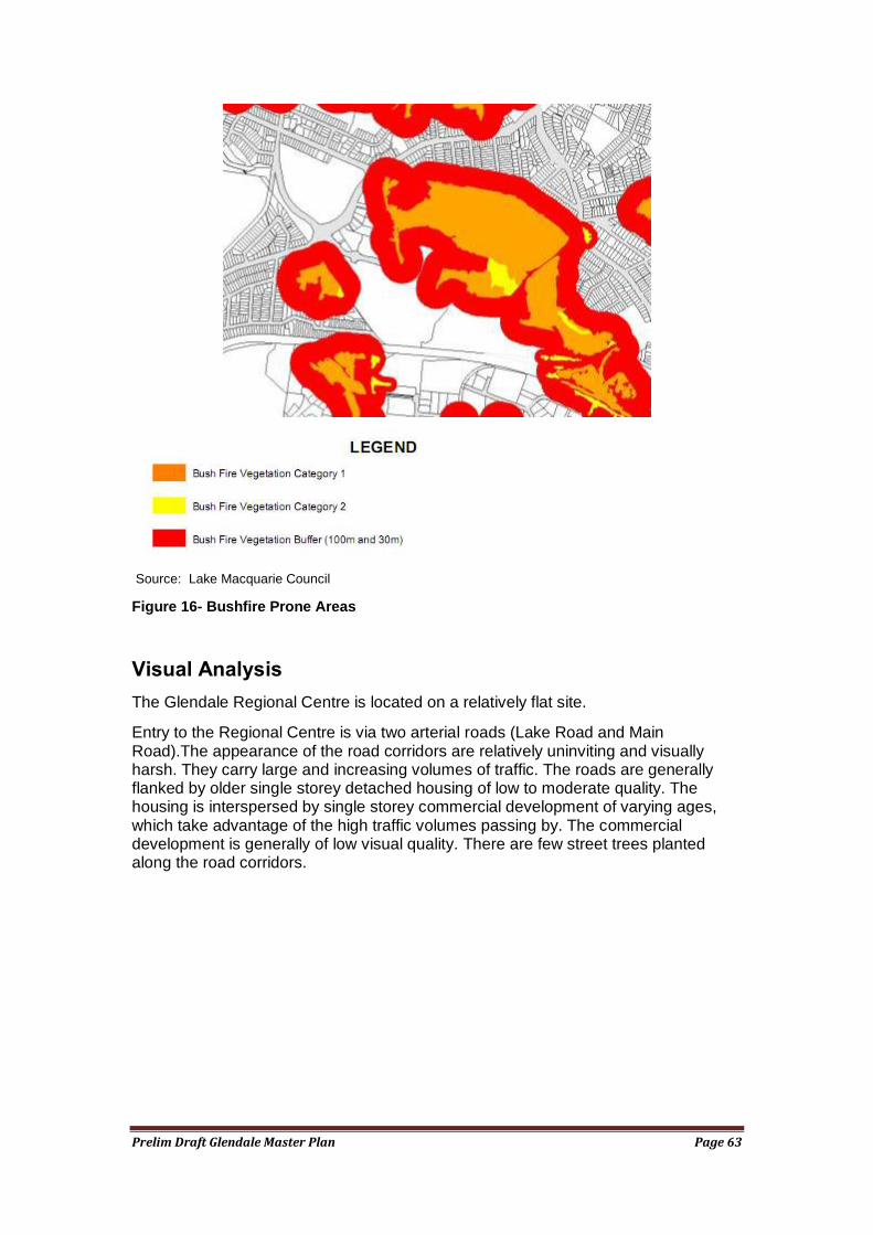
Prelim Draft Glendale Master Plan Page 63
Source: Lake Macquarie Council
Figure 16- Bushfire Prone Areas
Visual Analysis
The Glendale Regional Centre is located on a relatively flat site.
Entry to the Regional Centre is via two arterial roads (Lake Road and Main Road).The appearance of the road corridors are relatively uninviting and visually harsh. They carry large and increasing volumes of traffic. The roads are generally flanked by older single storey detached housing of low to moderate quality. The housing is interspersed by single storey commercial development of varying ages, which take advantage of the high traffic volumes passing by. The commercial development is generally of low visual quality. There are few street trees planted along the road corridors.
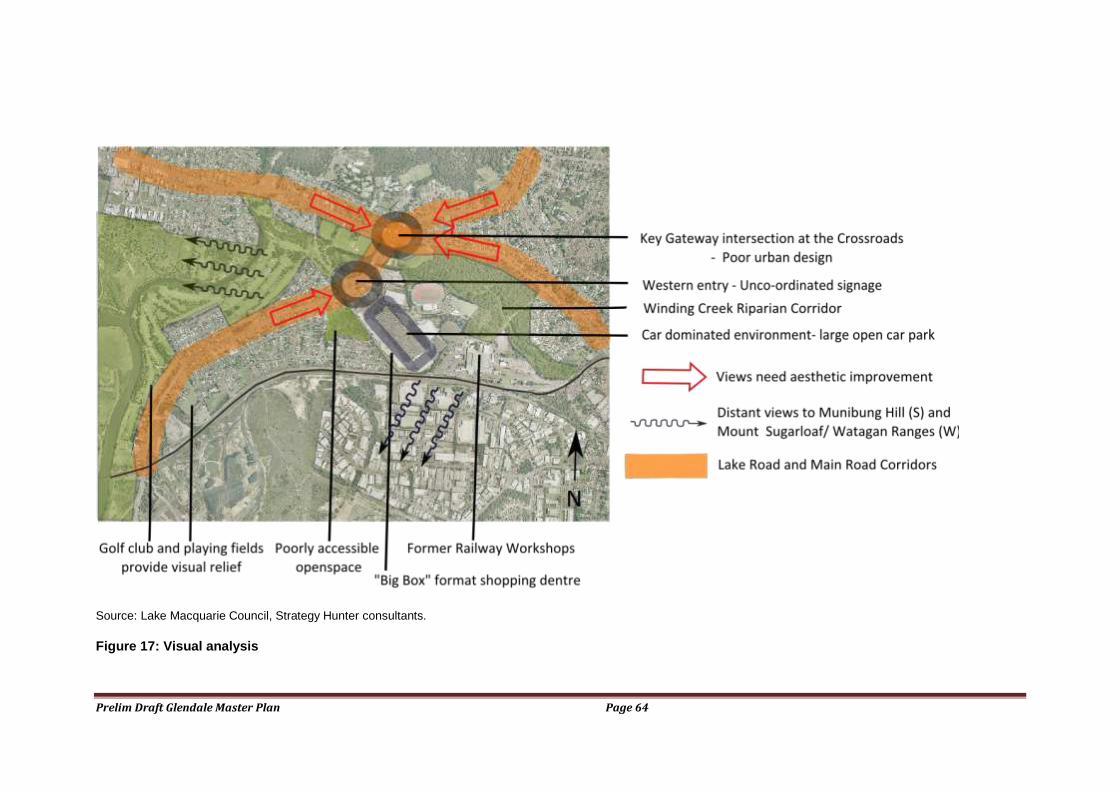
Prelim Draft Glendale Master Plan Page 64
Source: Lake Macquarie Council, Strategy Hunter consultants.
Figure 17: Visual analysis
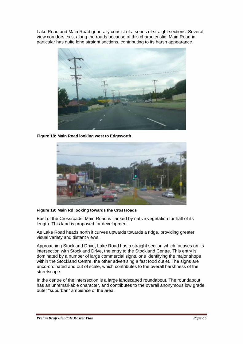
Prelim Draft Glendale Master Plan Page 65
Lake Road and Main Road generally consist of a series of straight sections. Several view corridors exist along the roads because of this characteristic. Main Road in particular has quite long straight sections, contributing to its harsh appearance.
Figure 18: Main Road looking west to Edgeworth
Figure 19: Main Rd looking towards the Crossroads
East of the Crossroads, Main Road is flanked by native vegetation for half of its length. This land is proposed for development.
As Lake Road heads north it curves upwards towards a ridge, providing greater visual variety and distant views.
Approaching Stockland Drive, Lake Road has a straight section which focuses on its intersection with Stockland Drive, the entry to the Stockland Centre. This entry is dominated by a number of large commercial signs, one identifying the major shops within the Stockland Centre, the other advertising a fast food outlet. The signs are unco-ordinated and out of scale, which contributes to the overall harshness of the streetscape.
In the centre of the intersection is a large landscaped roundabout. The roundabout has an unremarkable character, and contributes to the overall anonymous low grade outer ―suburban‖ ambience of the area.
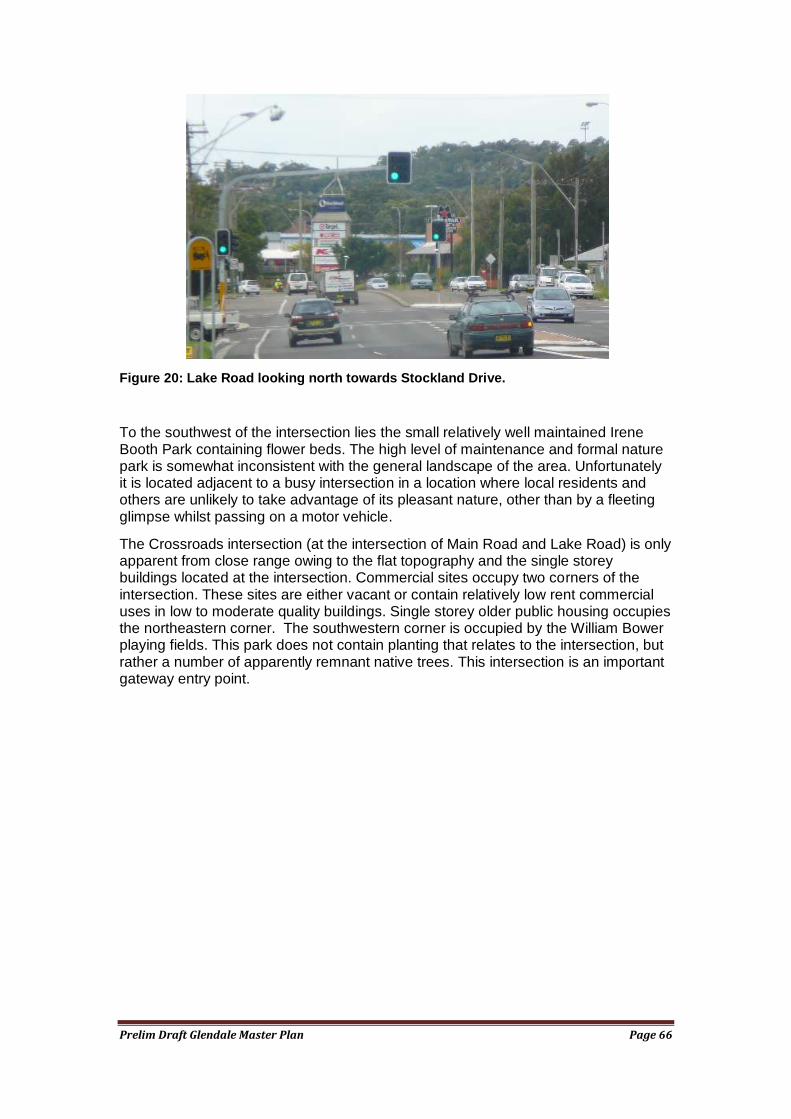
Prelim Draft Glendale Master Plan Page 66
Figure 20: Lake Road looking north towards Stockland Drive.
To the southwest of the intersection lies the small relatively well maintained Irene Booth Park containing flower beds. The high level of maintenance and formal nature park is somewhat inconsistent with the general landscape of the area. Unfortunately it is located adjacent to a busy intersection in a location where local residents and others are unlikely to take advantage of its pleasant nature, other than by a fleeting glimpse whilst passing on a motor vehicle.
The Crossroads intersection (at the intersection of Main Road and Lake Road) is only apparent from close range owing to the flat topography and the single storey buildings located at the intersection. Commercial sites occupy two corners of the intersection. These sites are either vacant or contain relatively low rent commercial uses in low to moderate quality buildings. Single storey older public housing occupies the northeastern corner. The southwestern corner is occupied by the William Bower playing fields. This park does not contain planting that relates to the intersection, but rather a number of apparently remnant native trees. This intersection is an important gateway entry point.
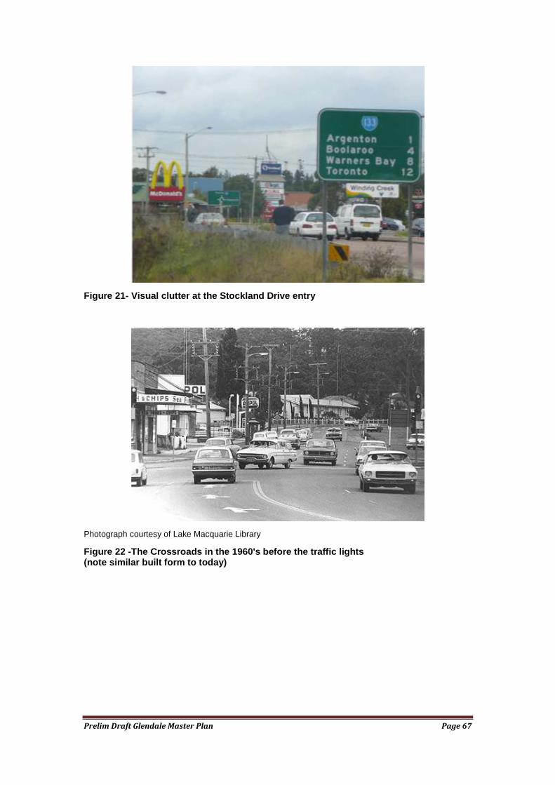
Prelim Draft Glendale Master Plan Page 67
Figure 21- Visual clutter at the Stockland Drive entry
Photograph courtesy of Lake Macquarie Library
Figure 22 -The Crossroads in the 1960's before the traffic lights (note similar built form to today)
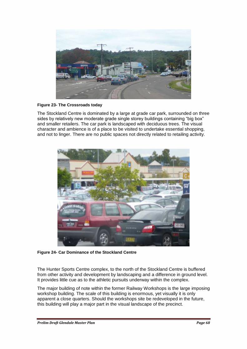
Prelim Draft Glendale Master Plan Page 68
Figure 23- The Crossroads today
The Stockland Centre is dominated by a large at grade car park, surrounded on three sides by relatively new moderate grade single storey buildings containing ―big box‖ and smaller retailers. The car park is landscaped with deciduous trees. The visual character and ambience is of a place to be visited to undertake essential shopping, and not to linger. There are no public spaces not directly related to retailing activity.
Figure 24- Car Dominance of the Stockland Centre
The Hunter Sports Centre complex, to the north of the Stockland Centre is buffered from other activity and development by landscaping and a difference in ground level. It provides little cue as to the athletic pursuits underway within the complex.
The major building of note within the former Railway Workshops is the large imposing workshop building. The scale of this building is enormous, yet visually it is only apparent a close quarters. Should the workshops site be redeveloped in the future, this building will play a major part in the visual landscape of the precinct.
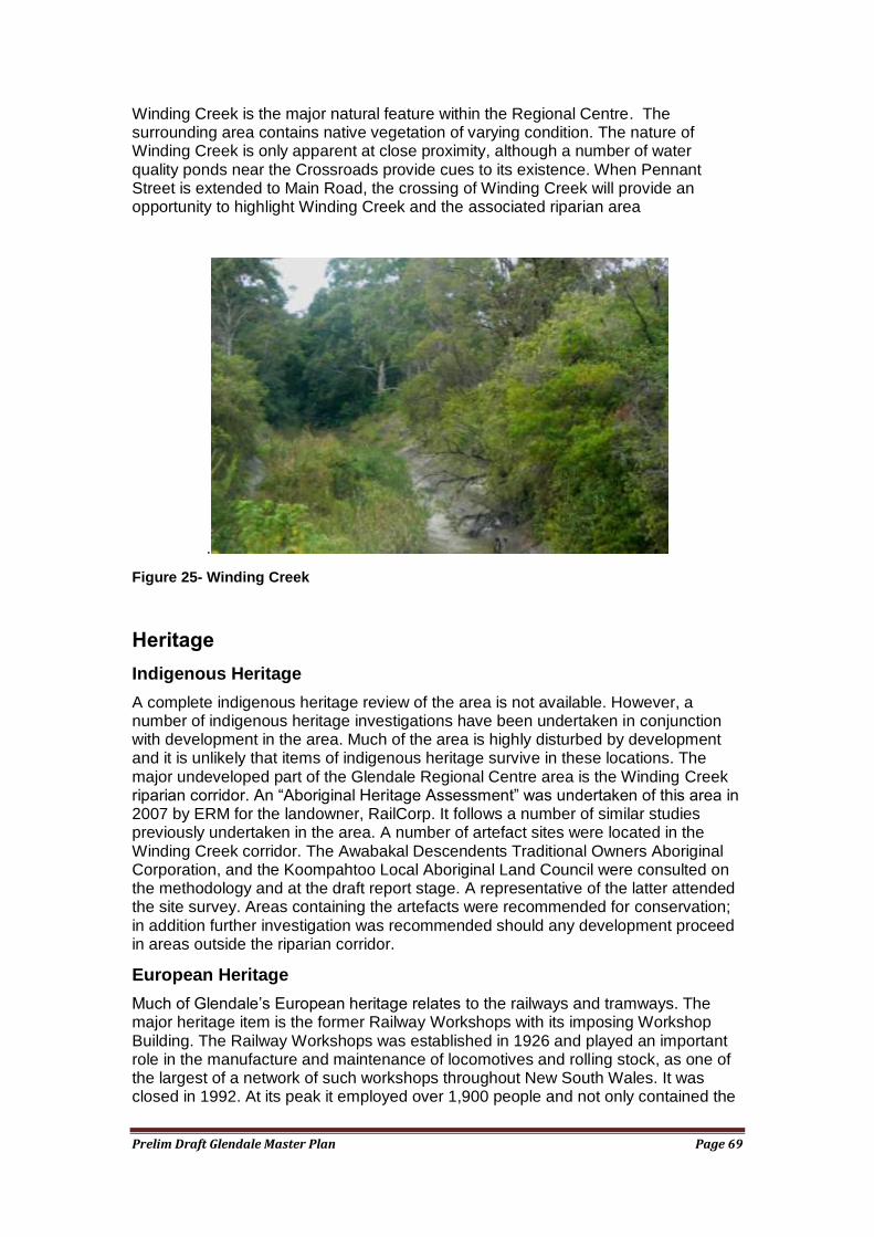
Prelim Draft Glendale Master Plan Page 69
Winding Creek is the major natural feature within the Regional Centre. The surrounding area contains native vegetation of varying condition. The nature of Winding Creek is only apparent at close proximity, although a number of water quality ponds near the Crossroads provide cues to its existence. When Pennant Street is extended to Main Road, the crossing of Winding Creek will provide an opportunity to highlight Winding Creek and the associated riparian area
.
Figure 25- Winding Creek
Heritage
Indigenous Heritage
A complete indigenous heritage review of the area is not available. However, a number of indigenous heritage investigations have been undertaken in conjunction with development in the area. Much of the area is highly disturbed by development and it is unlikely that items of indigenous heritage survive in these locations. The major undeveloped part of the Glendale Regional Centre area is the Winding Creek riparian corridor. An ―Aboriginal Heritage Assessment‖ was undertaken of this area in 2007 by ERM for the landowner, RailCorp. It follows a number of similar studies previously undertaken in the area. A number of artefact sites were located in the Winding Creek corridor. The Awabakal Descendents Traditional Owners Aboriginal Corporation, and the Koompahtoo Local Aboriginal Land Council were consulted on the methodology and at the draft report stage. A representative of the latter attended the site survey. Areas containing the artefacts were recommended for conservation; in addition further investigation was recommended should any development proceed in areas outside the riparian corridor.
European Heritage
Much of Glendale‘s European heritage relates to the railways and tramways. The major heritage item is the former Railway Workshops with its imposing Workshop Building. The Railway Workshops was established in 1926 and played an important role in the manufacture and maintenance of locomotives and rolling stock, as one of the largest of a network of such workshops throughout New South Wales. It was closed in 1992. At its peak it employed over 1,900 people and not only contained the
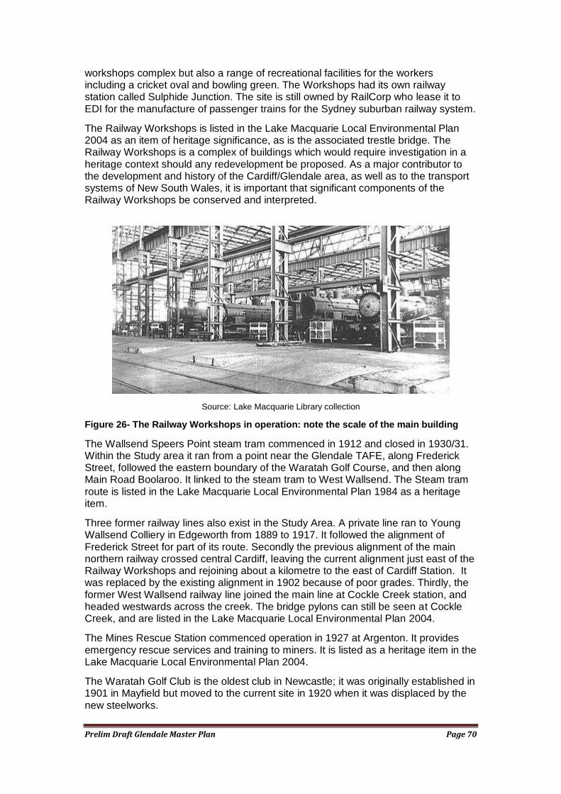
Prelim Draft Glendale Master Plan Page 70
workshops complex but also a range of recreational facilities for the workers including a cricket oval and bowling green. The Workshops had its own railway station called Sulphide Junction. The site is still owned by RailCorp who lease it to EDI for the manufacture of passenger trains for the Sydney suburban railway system.
The Railway Workshops is listed in the Lake Macquarie Local Environmental Plan 2004 as an item of heritage significance, as is the associated trestle bridge. The Railway Workshops is a complex of buildings which would require investigation in a heritage context should any redevelopment be proposed. As a major contributor to the development and history of the Cardiff/Glendale area, as well as to the transport systems of New South Wales, it is important that significant components of the Railway Workshops be conserved and interpreted.
Source: Lake Macquarie Library collection
Figure 26- The Railway Workshops in operation: note the scale of the main building
The Wallsend Speers Point steam tram commenced in 1912 and closed in 1930/31. Within the Study area it ran from a point near the Glendale TAFE, along Frederick Street, followed the eastern boundary of the Waratah Golf Course, and then along Main Road Boolaroo. It linked to the steam tram to West Wallsend. The Steam tram route is listed in the Lake Macquarie Local Environmental Plan 1984 as a heritage item.
Three former railway lines also exist in the Study Area. A private line ran to Young Wallsend Colliery in Edgeworth from 1889 to 1917. It followed the alignment of Frederick Street for part of its route. Secondly the previous alignment of the main northern railway crossed central Cardiff, leaving the current alignment just east of the Railway Workshops and rejoining about a kilometre to the east of Cardiff Station. It was replaced by the existing alignment in 1902 because of poor grades. Thirdly, the former West Wallsend railway line joined the main line at Cockle Creek station, and headed westwards across the creek. The bridge pylons can still be seen at Cockle Creek, and are listed in the Lake Macquarie Local Environmental Plan 2004.
The Mines Rescue Station commenced operation in 1927 at Argenton. It provides emergency rescue services and training to miners. It is listed as a heritage item in the Lake Macquarie Local Environmental Plan 2004.
The Waratah Golf Club is the oldest club in Newcastle; it was originally established in 1901 in Mayfield but moved to the current site in 1920 when it was displaced by the new steelworks.
Prelim Draft Glendale Master Plan Page 71
Another item of European heritage significance is the Anglican Church and Hall in Lake Road Argenton, also listed in the Lake Macquarie Local Environmental Plan 2004.
Natural environment
A study of ecological constraints of much of the undeveloped parts of the Study Area was undertaken by ERM in 2007 for RailCorp. This Study was the latest of a number of similar studies undertaken of the site, including by Forest Fauna Surveys/Ecopro and Fly by Night (1996) and ERM (1996).
Three vegetation communities have been identified (ERM, 2007, 12). These include Alluvial Moist Forest, Coastal Foothills Spotted Gum- Ironbark Forest and Coastal Plains Scribbly Gum Woodland.
The Alluvial Moist Forest (24.2 ha) occupies most of the undeveloped part of the Study Area. The moist areas north of Winding Creek are dominated by Eucalyptus acmenoides (white mahogany), Angophora floribunda (rough barked apple) and Eucalyptus saligna (Sydney Blue Gum). A dense midstorey, understorey and groundcover exist close to the creek. Significant invasion of exotic and weed species (especially Lantana and privet) occurs adjacent to Winding Creek. Elsewhere the vegetation density is generally moderate to sparse. In drier areas to the north of the Creek Eucalyptus piperita (Sydney Peppermint), Eucalyptus tereticornis (Forest Red Gum) can be found in addition to the species mentioned earlier. The Alluvial Tall Moist Forest is regarded as being of local conservation significance, and as a regionally significant vulnerable community (ERM, 2007). This community is likely to meet the definition of the Endangered Ecological Community River-Flat Eucalypt Forest on Coastal Floodplains.
Within the Coastal Foothills Spotted Gum- Ironbark Forest (1.7 ha) (located in the northwest of the Study Area in the vicinity of the former Maneela Oval) the canopy is dominated by Corymbia maculata with Eucalyptus paniculata (Grey Ironbark) and Eucalyptus acmenoides (White Mahogany). The area has been previously cleared and no mature trees are evident. Rare and threatened species which may occur in this community include Macrozamia flexuosa and Tetratheca juncea (ERM, 2007).
The Coastal Plains Scribbly Gum Woodland (1.5 ha) is located on the northern and northeastern periphery of the former Railway Workshops Oval. It contains an open overstorey dominated by Eucalyptus haemastoma , with Eucalyptus piperita, Eucalyptus agglomerata and Corymbia gummifera. The midstorey and groundcover are sparse. The community is a significant risk of fire and edge effects. Rare and threatened species that may occur include Tetratheca juncea, Acacia bynoeana and Crypotostylis hunteriana. The Scribbly Gum Woodland is regarded as being of local
conservation significance (ERM, 2007).
Six threatened species have been identified during surveys of the site (ERM 2007; ERM 1996; Forest Fauna Survey et al 1996). These are the powerful owl (Ninox strenua), squirrel glider (Petaurus norfolcensis) , eastern bent-wing bat (Miniopterus schreibersii oceanensis), little bent-wing bat (Miniopterus australis), greyheaded
flying fox (Pteropus poliocephalus) and rose crowned fruit dove (Ptilinopus regina).
Prelim Draft Glendale Master Plan Page 72
The 7(2) Conservation zone adjacent to Winding Creek will result in around 10.7 ha of alluvial tall moist forest remaining after development of the surrounding land. This is below the effective remnant size required to sustain a viable glider population. Furthermore, the population of squirrel gliders in the Study Area is largely isolated with no practical connectivity to nearby vegetation.
No roost sites for the powerful owl were identified in site surveys; it is likely the site is used for foraging. Nonetheless ERM (2007) recommend the retention of suitable roost trees, and the inspection of any hollow bearing trees prior to clearing.
The eastern bent-wing bat would use the area for foraging, and may roost in the culvert over Winding Creek. Appendix 2 provides a guide to the likelihood of threatened species on site, which would require further assessment at the development stage (ERM 2007).
ERM (2007) identified several key threats to the ecological values of the Study Area. They are:
Habitat Loss – both in terms of the loss of native vegetation and the loss of hollow bearing trees (which are becoming increasing rare). The loss of hollows may lead to many species dropping below their minimum viable population.
Habitat fragmentation – the nearest bushland is 400m away, with very poor connectivity except for more mobile flying species. The absence of corridor connectivity is of concern because it assists the viability of species by linking remnant bushland.
Edge Effects- these include changes in soil and water conditions and an increase in light penetration to the understorey. The provision of well managed buffer areas reduces edge effects.
Indirect effects- such as weed invasion
ERM (2007) assigned an ecological value of low, medium or high to parts of the Study Area, based on a number of criteria outlined in their Report (further detail can be found in Section 5.6 of their report). Generally, the high value area is the Alluvial Tall Moist Forest is less affected by edge effects. Moderate ecological value was assigned to the alluvial tall moist forest and coastal foothills spotted gum- ironbark forest affected by edge effects, such as lantana growth, moderate value areas also provided a buffer to the high value areas. The scribbly gum woodland community was assigned a moderate value. It is highly affected by fire and dumping and is unlikely to support viable populations of threatened flora. Low ecological value was assigned to cleared grassland areas. ERM (2007) note that a walking track or cycleway could be developed adjacent to Winding Creek in the highly disturbed areas (high weed encroachment), in conjunction with weed removal and rehabilitation measures.
ERM (2007) recommended:
A seven part test to assess the impact of any future development proposal to determine if the development is likely to have any impact on threatened species listed in the TSC Act.
Squirrel glider den trees be retained where possible on site
Habitat trees be retained on site where possible for retention of breeding habitat for squirrel gliders, powerful owls and eastern bent-wing bats
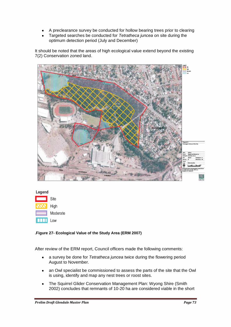
Prelim Draft Glendale Master Plan Page 73
A preclearance survey be conducted for hollow bearing trees prior to clearing
Targeted searches be conducted for Tetratheca juncea on site during the
optimum detection period (July and December)
It should be noted that the areas of high ecological value extend beyond the existing 7(2) Conservation zoned land.
.Figure 27- Ecological Value of the Study Area (ERM 2007)
After review of the ERM report, Council officers made the following comments:
a survey be done for Tetratheca juncea twice during the flowering period
August to November.
an Owl specialist be commissioned to assess the parts of the site that the Owl is using, identify and map any nest trees or roost sites.
The Squirrel Glider Conservation Management Plan: Wyong Shire (Smith 2002) concludes that remnants of 10-20 ha are considered viable in the short
Prelim Draft Glendale Master Plan Page 74
term with management intervention. This site is at this level now with around 27 ha of bushland left.
o This population is completely isolated –a decision needs to be made whether to manage this population by linking it to other habitat (there is another population to the North West) or to develop the site. This decision may be dependant on the findings of additional studies for the Powerful Owl.
o The local population would be significantly affected by any reduction in the size of the bushland fragment, and consequently a Species Impact Statement would be required for development of the site.
It is difficult to tell whether the north-eastern Squirrel Glider den tree is included in the high habitat area and if it is included what buffer distance, if any has been applied.
A number of threatened bat species may also use the site. It would be prudent to look at hollow bearing trees to ensure that no maturity sites will be affected.
An ecological assessment should be undertaken that covers all the undeveloped areas of the Regional Centre core as there are some areas that have not been covered.
The species identified in Table 3.2 of ERM's report (2007) (Appendix 2 to this report) should be targeted in further surveys preferably before development proposals are formulated.
The Alluvial Tall Moist Forest community is likely to meet the definition of the Endangered Ecological Community River-Flat Eucalypt Forest on Coastal Floodplains and this should be further investigated with proper flora survey including quadrats.
In summary, the Winding Creek corridor is of environmental significance and contains endangered species. However, it is a relatively isolated area of bushland and its small size makes the viability of these species marginal over the long term. Accordingly, further study needs to be undertaken, as outlined above, to determine the extent of these species, the impact of development and to determine the extent to which development can reasonably reduce the extent of vegetation.
A further issue, is the hydrological impact of development involving filling within the Winding Creek floodplain on water quality, stream health and flooding impacts. The later was researched some years ago by Dalland and Lucas, and this work should be reviewed in more detail in the light of contemporary modelling and influences, such as the impacts of potential climate change.
The above matters are particularly important for determining the potential development footprint north of Winding Creek. The Master plan is only able to provide a schematic definition of this footprint prior to this work being undertaken.
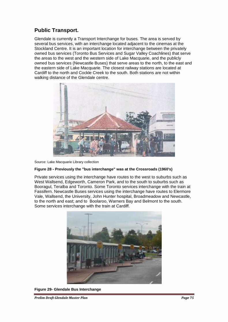
Prelim Draft Glendale Master Plan Page 75
Public Transport.
Glendale is currently a Transport Interchange for buses. The area is served by several bus services, with an interchange located adjacent to the cinemas at the Stockland Centre. It is an important location for interchange between the privately owned bus services (Toronto Bus Services and Sugar Valley Coachlines) that serve the areas to the west and the western side of Lake Macquarie, and the publicly owned bus services (Newcastle Buses) that serve areas to the north, to the east and the eastern side of Lake Macquarie. The closest railway stations are located at Cardiff to the north and Cockle Creek to the south. Both stations are not within walking distance of the Glendale centre.
Source: Lake Macquarie Library collection
Figure 28 - Previously the "bus interchange" was at the Crossroads (1960's)
Private services using the interchange have routes to the west to suburbs such as West Wallsend, Edgeworth, Cameron Park, and to the south to suburbs such as Booragul, Teralba and Toronto. Some Toronto services interchange with the train at Fassifern. Newcastle Buses services using the interchange have routes to Elermore Vale, Wallsend, the University, John Hunter hospital, Broadmeadow and Newcastle, to the north and east; and to Boolaroo, Warners Bay and Belmont to the south. Some services interchange with the train at Cardiff.
Figure 29- Glendale Bus Interchange
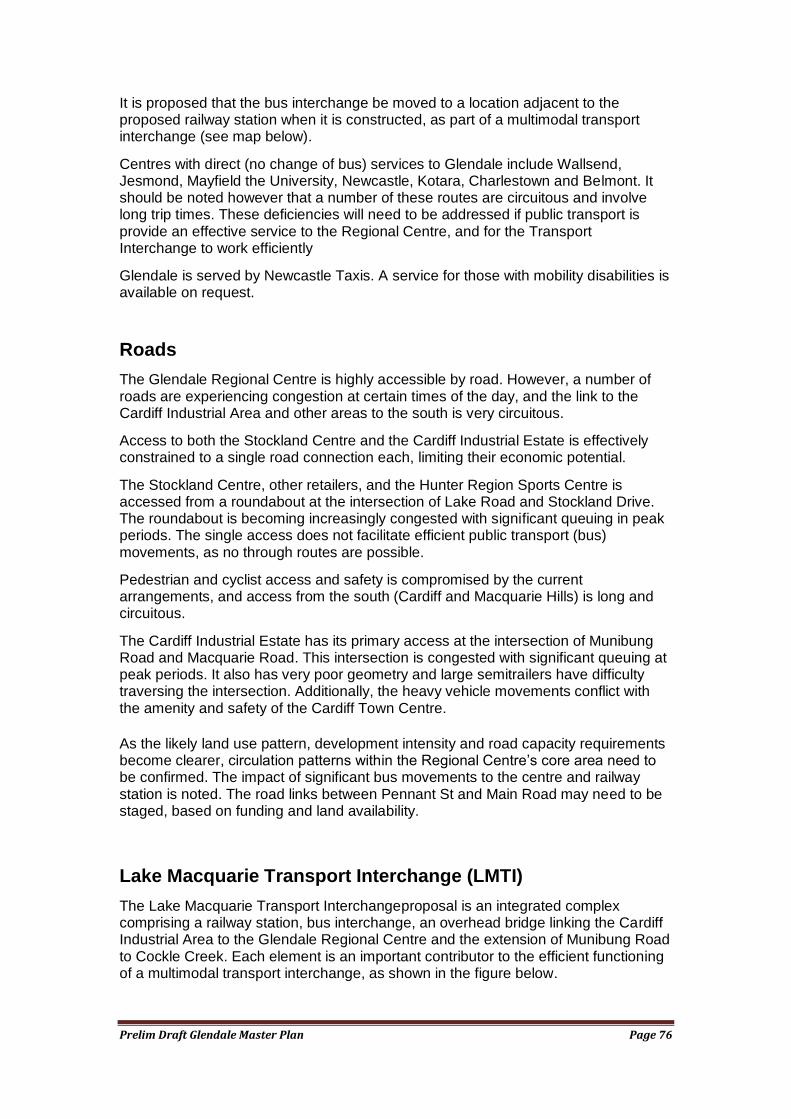
Prelim Draft Glendale Master Plan Page 76
It is proposed that the bus interchange be moved to a location adjacent to the proposed railway station when it is constructed, as part of a multimodal transport interchange (see map below).
Centres with direct (no change of bus) services to Glendale include Wallsend, Jesmond, Mayfield the University, Newcastle, Kotara, Charlestown and Belmont. It should be noted however that a number of these routes are circuitous and involve long trip times. These deficiencies will need to be addressed if public transport is provide an effective service to the Regional Centre, and for the Transport Interchange to work efficiently
Glendale is served by Newcastle Taxis. A service for those with mobility disabilities is available on request.
Roads
The Glendale Regional Centre is highly accessible by road. However, a number of roads are experiencing congestion at certain times of the day, and the link to the Cardiff Industrial Area and other areas to the south is very circuitous.
Access to both the Stockland Centre and the Cardiff Industrial Estate is effectively constrained to a single road connection each, limiting their economic potential.
The Stockland Centre, other retailers, and the Hunter Region Sports Centre is accessed from a roundabout at the intersection of Lake Road and Stockland Drive. The roundabout is becoming increasingly congested with significant queuing in peak periods. The single access does not facilitate efficient public transport (bus) movements, as no through routes are possible.
Pedestrian and cyclist access and safety is compromised by the current arrangements, and access from the south (Cardiff and Macquarie Hills) is long and circuitous.
The Cardiff Industrial Estate has its primary access at the intersection of Munibung Road and Macquarie Road. This intersection is congested with significant queuing at peak periods. It also has very poor geometry and large semitrailers have difficulty traversing the intersection. Additionally, the heavy vehicle movements conflict with the amenity and safety of the Cardiff Town Centre.
As the likely land use pattern, development intensity and road capacity requirements become clearer, circulation patterns within the Regional Centre‘s core area need to be confirmed. The impact of significant bus movements to the centre and railway station is noted. The road links between Pennant St and Main Road may need to be staged, based on funding and land availability.
Lake Macquarie Transport Interchange (LMTI)
The Lake Macquarie Transport Interchangeproposal is an integrated complex comprising a railway station, bus interchange, an overhead bridge linking the Cardiff Industrial Area to the Glendale Regional Centre and the extension of Munibung Road to Cockle Creek. Each element is an important contributor to the efficient functioning of a multimodal transport interchange, as shown in the figure below.
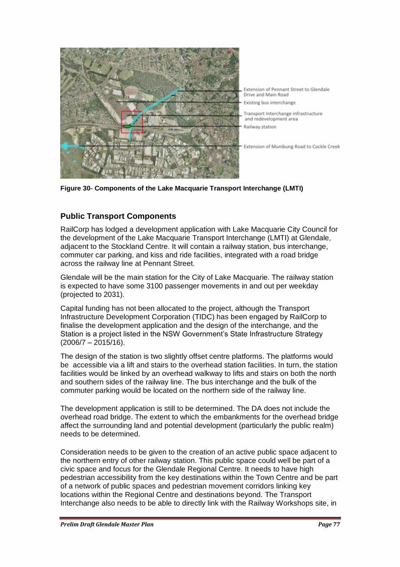
Prelim Draft Glendale Master Plan Page 77
Figure 30- Components of the Lake Macquarie Transport Interchange (LMTI)
Public Transport Components
RailCorp has lodged a development application with Lake Macquarie City Council for the development of the Lake Macquarie Transport Interchange (LMTI) at Glendale, adjacent to the Stockland Centre. It will contain a railway station, bus interchange, commuter car parking, and kiss and ride facilities, integrated with a road bridge across the railway line at Pennant Street.
Glendale will be the main station for the City of Lake Macquarie. The railway station is expected to have some 3100 passenger movements in and out per weekday (projected to 2031).
Capital funding has not been allocated to the project, although the Transport Infrastructure Development Corporation (TIDC) has been engaged by RailCorp to finalise the development application and the design of the interchange, and the Station is a project listed in the NSW Government‘s State Infrastructure Strategy (2006/7 – 2015/16).
The design of the station is two slightly offset centre platforms. The platforms would be accessible via a lift and stairs to the overhead station facilities. In turn, the station facilities would be linked by an overhead walkway to lifts and stairs on both the north and southern sides of the railway line. The bus interchange and the bulk of the commuter parking would be located on the northern side of the railway line.
The development application is still to be determined. The DA does not include the overhead road bridge. The extent to which the embankments for the overhead bridge affect the surrounding land and potential development (particularly the public realm) needs to be determined.
Consideration needs to be given to the creation of an active public space adjacent to the northern entry of other railway station. This public space could well be part of a civic space and focus for the Glendale Regional Centre. It needs to have high pedestrian accessibility from the key destinations within the Town Centre and be part of a network of public spaces and pedestrian movement corridors linking key locations within the Regional Centre and destinations beyond. The Transport Interchange also needs to be able to directly link with the Railway Workshops site, in
Prelim Draft Glendale Master Plan Page 78
order to improve pubic transport accessibility for the its workers, and also to provide for future intensive mixed use development of that site.
Road Link Components
A proposal has been developed to extend Pennant Street (Cardiff Industrial Estate) over the main northern railway line to the intersection of Glendale Drive and Main Road (see figure 9 below), as an integrated part of the Glendale Transport Interchange. This link would provide a second entrance to the Cardiff Industrial Estate. In doing so, it would provide a free flowing and convenient route for heavy vehicles travelling to the Port and F3 Freeway, and relieve the Munibung Road/ Macquarie Road intersection. Modelling indicates that some 16,000 vehicles per day will use the link, of which around 1,500 will be heavy vehicles.
Preliminary concept design and costing have been undertaken, and some property acquisition has been undertaken. This project is of regional significance because of the significant positive impact it will have on economic activity in the Cardiff/ Glendale employment node and its contribution to the prosperity of the Region. The project will also provide bus and commuter access from the south to the transport interchange, considerably improving its functionality. No funding has been allocated to construct this road link, however an AUSLINK application was made by Lake Macquarie City Council in 2006.
An associated proposal has been developed to extend Stockland Drive to link with the Glendale Drive/ Main Road intersection via the proposed extended Pennant Street. This proposal will provide an additional access to the Stockland Centre and transport interchange. It will relieve congestion of the Lake Road/Stockland Drive roundabout. The additional access will greatly improve bus and commuter access from the north to the transport interchange. Partial funding is available to assist in the construction of this road link as a result of existing development consent conditions and likely obligations resulting from land development in the future.
Both the Pennant Street overbridge link and the Stockland Drive link will also permit bus routes to enter the Stockland Centre and transport interchange area through one access point and exit via another, instead of retracing their route back through the congested Lake Road/ Stockland Drive roundabout. This will significantly improve the efficiency and convenience of the bus network and transport interchange.
The Pennant Street overbridge will also greatly improve the efficiency of access to the transport interchange from existing urban areas to the south.
The importance of the Pennant St overbridge is increased by the proposed construction of new roads associated with the redevelopment of the former Pasminco site, to the south of Glendale. As part of the site redevelopment, Munibung Road will be extended to intersect with Lake Road at Cockle Creek. The Pasminco site redevelopment will generate a large amount of traffic movements from a mixture of light industrial, commercial and housing development, all of which will benefit from the additional access to Glendale and a reduced reliance on Lake Road.
Land has been zoned to accommodate all the proposed roads discussed above. Research undertaken for the Glendale Master Plan has highlighted the critical importance of the completion of the road links to allow the Glendale area to reach its potential, and to meet the employment and dwelling targets set by the Lower Hunter Regional Strategy.
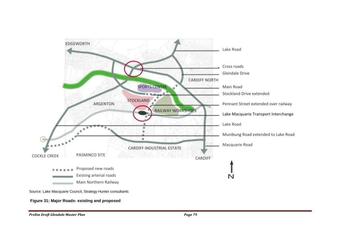
Prelim Draft Glendale Master Plan Page 79
Source: Lake Macquarie Council, Strategy Hunter consultants
Figure 31: Major Roads- existing and proposed
Prelim Draft Glendale Master Plan Page 80
Detailed design work has not been carried out, but sufficient preliminary work has been done to determine the desirability, viability and indicative cost benefit of the proposal.
Issues to be addressed in the design are to ensure that pedestrian, cyclist and vehicular connectivity is facilitated between the Railway Workshops site and the parts of the Regional Centre to the west (eg. Stockland Centre and Transport Interchange). Through traffic, especially heavy vehicles, should be discouraged from using Stockland Drive, and confined as much as possible to the arterial road system. Noise generated from traffic on the new road link should be considered in the design of the new road and in the planning of adjacent areas.
Whilst some property acquisition has occurred and development consent obligations exist to build some components of the proposed roads, the balance of the funding to complete the link is not allocated. Funding of the roads is a shared responsibility.
In April 2006 an application was made to AUSLINK by Lake Macquarie City Council for partial funding of the Pennant Street overbridge and associated road link components of the GTI, as a project of regional significance. This grant application is yet to be determined. More recently Council has made representations to the State and Federal Governments to seek assistance with the preparation of a Development application for the road link. Details of these proposals are shown in the figure below.
Synopsis of Transport Interchange Impacts
The Glendale Transport Interchange is a strategically important project that will provide significant economic & employment growth in Lake Macquarie and the Hunter Region.
The project worth approximately $60million, integrates rail, bus and road transport into a central hub, which also connects the industrial and retail areas in Cardiff and Glendale. The GTI and associated development will provide considerable opportunity for economic development and job creation in Lake Macquarie.
The GTI will improve traffic movements, easing congestion at peak times. Currently the main north/south rail line divides two suburbs; the interchange will link Pennant Street in Cardiff with Glendale Drive, providing heavy road users with more direct access to the F3 Freeway and the Port of Newcastle.
Modelling indicates that some 16,000 vehicles per day will use the link, of which around 1,500 will be heavy vehicles.
The size and complexity of the GTI means that all levels of government must have financial and strategic input.
Benefits of constructing the GTI:
Increased economic development and job creation at a local and regional level;
Improved accessibility and safety for pedestrians and cyclists
Improved public transport
Improved traffic flow
Heavy vehicles bypass Cardiff
Better performance of the Regional Centre, including Stockland Centre The design of the road links associated with the GTI will need to ensure that
connectivity is maintained throughout the Regional Centre core area and that noise impacts of traffic using the new links is well managed.
Prelim Draft Glendale Master Plan Page 81
Glendale Stockland Centre
The Stockland Centre is discussed in a number of places within this report. The Centre has over 50,000 square metres of floorspace, most of which is devoted to retailing.
It contains two discount department stores, two major supermarkets, a minor supermarket and a range of smaller specialty shops and service outlets. Unlike most major shopping centres, the public common areas are all open, essentially comprising a sheltered footpath facing a large at grade open car park around which the shops are located. The only climate controlled space is within the shops.
The Centre is arranged on three sides of the car park, with a cinema complex and bus interchange on the fourth side.
The overall impression of the Centre is the dominance of cars and car parking, and the ambience is not unlike a large bulky goods retail development.
The Centre‘s design does not reflect contemporary shopping centre design, which provides a variety of open and climate controlled spaces in a variety of settings. It is understood that Stockland is examining options for a more contemporary and more functional Centre.
The design of the Centre does not relate to the surrounding neighbourhood. Additionally the interface with the proposed Transport Interchange is problematic as it does not seem to have been considered in the design of the existing layout of the Centre. Some redesign of the Stockland Centre will be necessary to ensure the efficient and safe operation of the Transport Interchange, and for the Centre to capitalise on the presence of the Transport Interchange.
It is highly likely the Centre will expand considerably as the Regional Centre grows. This will provide an opportunity to address many of the deficiencies of the Centre, and to provide a modern centre with an element of mixed use.
Hunter Sports Centre
The Hunter Sports Centre (HSC) is located just to the north east of the Stockland Centre. It is owned by Lake Macquarie City Council, but is operated by a non profit incorporated body.
It includes a range of Olympic standard facilities comprising
Athletics Centre with a 9-lane Olympic running track with a 10 lane main straight. The track surface is Rekotan synthetic
Gymnastics Centre with 2448 square metre floor space. The equipment is of Olympic standard
Catering area with full kitchen facilities for functions Wheelchair access to all areas and private wheelchair change rooms Weights area for athletes and small group fitness clients First aid / physiotherapy room Soccer field in the centre of the track Lighting for night events Access for news crews with facilities for outside broadcast
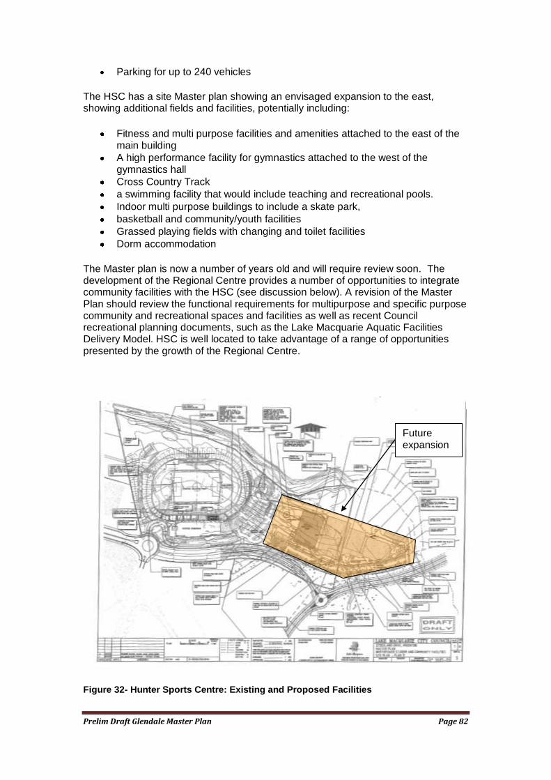
Prelim Draft Glendale Master Plan Page 82
Parking for up to 240 vehicles
The HSC has a site Master plan showing an envisaged expansion to the east, showing additional fields and facilities, potentially including:
Fitness and multi purpose facilities and amenities attached to the east of the main building
A high performance facility for gymnastics attached to the west of the gymnastics hall
Cross Country Track
a swimming facility that would include teaching and recreational pools.
Indoor multi purpose buildings to include a skate park,
basketball and community/youth facilities
Grassed playing fields with changing and toilet facilities
Dorm accommodation
The Master plan is now a number of years old and will require review soon. The development of the Regional Centre provides a number of opportunities to integrate community facilities with the HSC (see discussion below). A revision of the Master Plan should review the functional requirements for multipurpose and specific purpose community and recreational spaces and facilities as well as recent Council recreational planning documents, such as the Lake Macquarie Aquatic Facilities Delivery Model. HSC is well located to take advantage of a range of opportunities presented by the growth of the Regional Centre.
Figure 32- Hunter Sports Centre: Existing and Proposed Facilities
Future expansion
Prelim Draft Glendale Master Plan Page 83
Civic and Community Role
At present, beyond the purchase of goods and services, the civic and community role of the Glendale Regional Centre is mainly limited to the operation of the Hunter Sports Centre. If Glendale is to mature beyond an aggregation of largely commercially oriented land uses into a functional regional centre, it will need to develop a civic and community role. As it grows to become the most significant centre in Lake Macquarie, the need for a civic and community focus will grow.
Typically the community infrastructure found in a major regional centre would include many of the following:
a higher order community centre
diverse passive and active recreational activities
cultural facilities, displays and activities
entertainment facilities
a higher order library
public meeting places and spaces
service delivery points for government services
a place of public administration and decision making often based in a symbolic building, such as a town hall
Public spaces which provide for people to meet and gather are essential. These spaces need to be inviting, shared by different users, accessible, secure and provide for a range of settings. They also need to be reflective of local culture. Public art and community involvement in the design of spaces are impact elements in building residents identification with, and use of public spaces and the public domain generally. These strategies will contribute to Glendale being unique and memorable and identifiable with Lake Macquarie, not just another anonymous formularised regional centre.
The public spaces must be linked by a pedestrian movement network. This network should directly link important places and destinations. It should be easy to understand and navigate, be inviting and safe.
The development of community places and spaces within the Regional Centre should begin with an audit of the community needs that need to be met. The needs should be not be expressed in terms of buildings and infrastructure, such as a senior citizens centre, but rather as functions that need to be performed, such as places to meet, or spaces for exhibitions, The functional audit will help identify common needs and requirements, around which community infrastructure can be designed. A result of this approach will be the development of multipurpose facilities which integrate a range of uses.
Multipurpose buildings also recognise the convergence of many types of facilities which previously had a single very defined purpose. For example, libraries increasingly exhibit many of the functions of a community centre (meeting spaces and offices), a museum (historical collections) and an arts centre (cultural displays and activities). The growth of information technology and computers has accelerated convergence by making information and collections that were previously only available in defined places, such as an art gallery, available online anywhere.
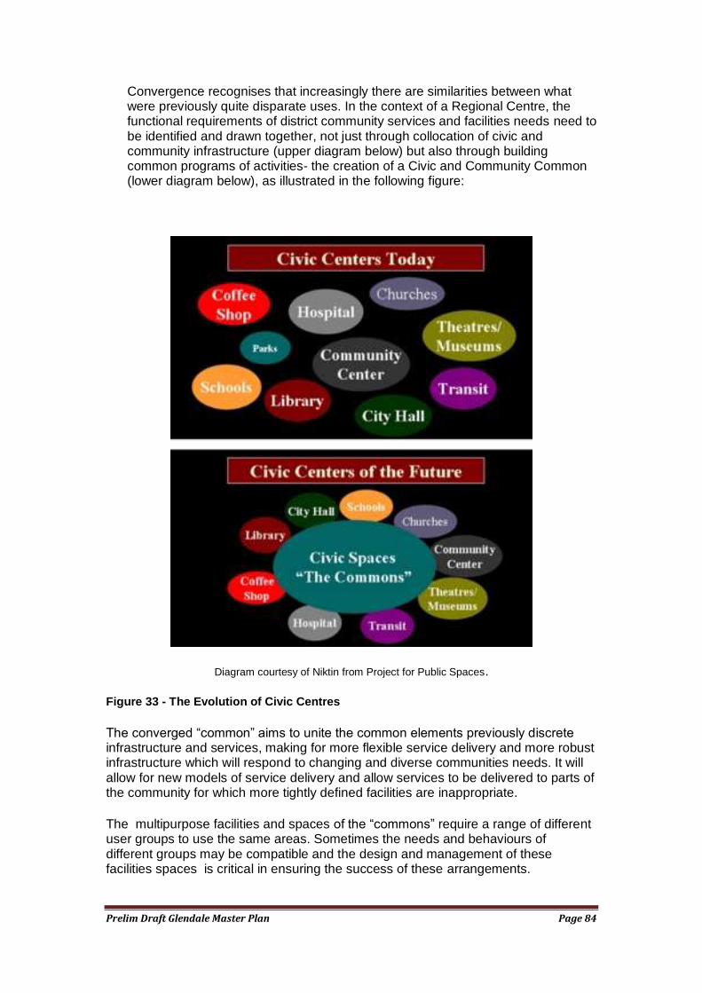
Prelim Draft Glendale Master Plan Page 84
Convergence recognises that increasingly there are similarities between what were previously quite disparate uses. In the context of a Regional Centre, the functional requirements of district community services and facilities needs need to be identified and drawn together, not just through collocation of civic and community infrastructure (upper diagram below) but also through building common programs of activities- the creation of a Civic and Community Common (lower diagram below), as illustrated in the following figure:
Diagram courtesy of Niktin from Project for Public Spaces.
Figure 33 - The Evolution of Civic Centres
The converged ―common‖ aims to unite the common elements previously discrete infrastructure and services, making for more flexible service delivery and more robust infrastructure which will respond to changing and diverse communities needs. It will allow for new models of service delivery and allow services to be delivered to parts of the community for which more tightly defined facilities are inappropriate.
The multipurpose facilities and spaces of the ―commons‖ require a range of different user groups to use the same areas. Sometimes the needs and behaviours of different groups may be compatible and the design and management of these facilities spaces is critical in ensuring the success of these arrangements.
Prelim Draft Glendale Master Plan Page 85
Community services and facilities planning for the Glendale Regional Centre should adopt the convergence approach and should strive to establish a ―civic and community commons‖ by basing the planning framework on a functional assessment of need.
It should be noted that Council is presently investigating relocating its administration centre from Speers Point to Glendale. Findings from a recent feasibility report commissioned by council, favoured the relocation to Glendale by 2018 both on financial and strategic planning grounds, however a decision to support these recommendations is yet to be made and community consultation will occur in the near future. The feasibility study did not identify any particular site/location within the Glendale Town Centre.
Council‘s Section 94 Plan identifies Glendale as the location for youth facilities, a multipurpose community centre and a district library.
The Glendale Regional Centre is an appropriate location for such facilities and they would add value to the Regional Centre. A number of locations within the Regional Centre appear appropriate such as adjacent to the transport interchange, or as part of prominent gateway building at the Crossroads. However, in planning the facilities, the potential for convergence should be considered. The Hunter Sports Centre may offer a range of spaces that could be collaboratively used for a range of purposes. Similarly, an entertainment precinct within the Regional Centre may offer opportunities for the location of community activities in a mutually beneficial manner. It is important that all these (and other) options are canvassed on the community services and facilities planning process.
The Hunter Sports Centre already delivers a range of high order recreational services and has a plan to guide its further expansion. Its business planning needs to consider not only its large district catchment for many of its activities, but also the needs of an increasing local population as the vicinity of the Glendale Regional Centre intensifies. Additionally, should an assessment of the Council owned William Bower sportsfields indicate the desirability of their relocation to land further east along Main Road, they might be able to be functionally linked to the Hunter Sports Centre to provide a recreational complex of significant scale. This is worthy of further investigation.
Glendale has no service delivery points for Government services, such as Centrelink. The closest Medicare access point in the Boolaroo pharmacy, and the closest Medicare office is at Wallsend. As a regional centre, it would be reasonable to expect a range of Government service points, and they need to be made aware of the new Regional Centre and urged to establish there.
Council and other government organisations will need to commit to the Regional Centre. The increased accessibility of Glendale as a result of the operation of the transport interchange will make it a very attractive place from which to offer community facilities, services and activities.
Sustainability
There is increasing interest in reducing the resource consumption of urban areas, and in reducing their carbon emissions. As an emerging regional centre, and one that
Prelim Draft Glendale Master Plan Page 86
will assume an increasingly high profile over time, it is important that Glendale provide a leadership role in sustainability.
The transit orientation of the Centre as a result of the development of the transport interchange and the response of the surrounding developments to this infrastructure will be a key contributor to the environmental performance of the Centre. Equally, the development of efficient pedestrian and bicycle movement network within the intensified surroundings of the Centre will play their role in reducing the dependence on private motor vehicles.
However, each development must also play its part by adopting energy efficient technology and practices. The maximum impact will be achieved when developments on site work together and adopt techniques to achieve efficiencies. For example, low grade waste from one development may be useful to another, or large unimpeded roof areas in one development may provide the location for solar panels to serve another‘s needs. Water management may be most effective when practiced on a collective basis. A co-operative approach is required.
Council has a role in facilitating these types of approaches and ensuring that these matters are considered at a development formulation and application stage, as well as part of ongoing site management Council provided infrastructure and spaces within the Glendale Regional Centre should provide very visible demonstrations of sustainable practice in their design and throughout their lifecycle.
Prelim Draft Glendale Master Plan Page 87
Setting the Context for a Regional Centre
A key element of a Regional Centre is the delivery of high order functions, and the provision of a sense of place and a standard of urban design commensurate with its higher order status. Whilst people and their activities are the real drivers of a successful Regional Centre, the spatial layout of the Centre, its buildings and its spaces, provide the ―stage‖ upon which these activities are able to take place. Buildings and spaces are critical to the operation of a true regional community centre. They can greatly assist or hinder the activities which people undertake and their willingness to participate in what the Regional Centre has to offer. Hence, much of the discussion below focuses on the built and spatial environment.
A functional Regional Centre does not sit in isolation. For it to perform its role it should be highly accessible to its catchment and beyond. It should also be supported by a context area which provides a level of intensity of activity and a diversity of land use reflective of regional level functions. For example, larger scale offices, high density housing, entertainment areas, mixed use, and significant community facilities and service outlets are contributory to the efficient functioning of a regional centre.
In the case of Glendale, its location in one of the most accessible points in Lake Macquarie, its position on the main northern railway line (with a proposed transport interchange), and its role as ultimately the most significant centre in the Local Government Area, mean that it is an appropriate location for higher order civic and government administrative functions.
Therein lies what is probably the main challenge in the development of Glendale. As the Market Assessment Report for the precincts comprises the Regional Centre reveals (see later for details), the Glendale area does not yet have land values across the board that would support the level of intensity of development that is commensurate with a regional centre. However, it does have the potential to achieve this over time and some land uses may be viable earlier than others. Retailing may be one example of this. Office development may be another should tenanting opportunities arise in a timely fashion.
The challenge is to guide the development of the Glendale Regional Centre towards its final development form without development in the interim reducing or sterilising opportunities for more intensive development over the longer term.
This is particularly the case with residential development in the context corridors. Lower intensity residential development in the short term will sterilise sites from achieving their medium and long term potential, largely because of strata titling and ownership of the individual units. In turn, this will affect the carrying capacity of the corridors and their ability to support a viable public transport system, and so on.
The second major challenge is to set urban design guidelines which can guide development, of buildings and infrastructure, such as roads, as well as activity zones and open spaces from an early stage. As the development of sites occurs, the building blocks of the desired urban design theme will be incrementally put into place and over time a coherent Regional Centre will emerge. In Glendale‘s case this is likely to take some decades to complete. Consequently, any urban design guidelines must be robust and capable of adapting to changing development trends.
The Master Plan should establish urban design guidelines for both the site and its surroundings.
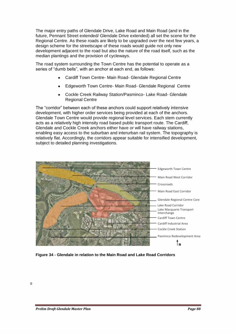
Prelim Draft Glendale Master Plan Page 88
The major entry paths of Glendale Drive, Lake Road and Main Road (and in the future, Pennant Street extended/ Glendale Drive extended) all set the scene for the Regional Centre. As these roads are likely to be upgraded over the next few years, a design scheme for the streetscape of these roads would guide not only new development adjacent to the road but also the nature of the road itself, such as the median plantings and the provision of cycleways.
The road system surrounding the Town Centre has the potential to operate as a series of ―dumb bells‖, with an anchor at each end, as follows:
Cardiff Town Centre- Main Road- Glendale Regional Centre
Edgeworth Town Centre- Main Road- Glendale Regional Centre
Cockle Creek Railway Station/Pasminco- Lake Road- Glendale Regional Centre
The ―corridor‖ between each of these anchors could support relatively intensive development, with higher order services being provided at each of the anchors. Glendale Town Centre would provide regional level services. Each stem currently acts as a relatively high intensity road based public transport route. The Cardiff, Glendale and Cockle Creek anchors either have or will have railway stations, enabling easy access to the suburban and interurban rail system. The topography is relatively flat. Accordingly, the corridors appear suitable for intensified development, subject to detailed planning investigations.
Figure 34 - Glendale in relation to the Main Road and Lake Road Corridors
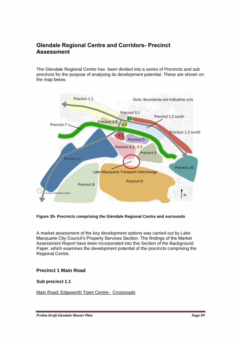
Prelim Draft Glendale Master Plan Page 89
Glendale Regional Centre and Corridors- Precinct Assessment
The Glendale Regional Centre has been divided into a series of Precincts and sub precincts for the purpose of analysing its development potential. These are shown on the map below.
Figure 35- Precincts comprising the Glendale Regional Centre and surrounds
A market assessment of the key development options was carried out by Lake Macquarie City Council‘s Property Services Section. The findings of the Market Assessment Report have been incorporated into this Section of the Background Paper, which examines the development potential of the precincts comprising the Regional Centre.
Precinct 1 Main Road
Sub precinct 1.1
Main Road: Edgeworth Town Centre- Crossroads
Prelim Draft Glendale Master Plan Page 90
This corridor is the main entry to the growing Northlakes urban fringe development. It is anchored in the west by the Edgeworth Town Centre. Existing development on the corridor west of Lake Road comprises single detached residential dwellings interspersed with clusters of commercial and industrial uses. Main Road is likely to experience increasing motor vehicle traffic and is road based public transport corridor
The Edgeworth Town Centre is still in a developmental phase and is lacking in focus and coherence. It contains a primary school, a community centre and small library in addition to retail functions. The retail area appears to be underperforming. The community facilities are relatively dated and will need replacement in the future.
A recreation/ open space complex is located to the south of the Edgeworth Town Centre, as is a small industrial area.
Main Road is in need of streetscape improvement and this is made difficult by the presence of overhead power. Council is undertaking a streetscape upgrade design for the road for several hundred metres either side of the Edgeworth Town Centre.
The corridor is affected by mine subsidence. It is closer to the less intensive urban fringe. Generally 3-4 storey development may be possible along this corridor.
Market demand for high rise development in this area in the short to medium term would only support values at the lower end of the market. Developers that erect medium density apartments will construct upper levels to obtain views and attract a premium value. Similar developments that are currently in planning and construction stages in superior locations will supply the market adequately in the short term. An existing mixed use development located opposite the Coles Shopping Centre commenced construction in 2005 and is partially complete. The site has been for sale for an extended period of time supporting the notion that there is currently no demand for this type of development.
With the development of the Pambulong Shopping Centre at Cameron Park, the area will provide a corridor for the two anchor retail areas (Pambulong and Glendale Super Centre) and the corridor will support higher density residential in the medium to longer term.
Sub precinct 1.2
Main Road: Crossroads- Railway Underpass
Development on the Main Road corridor from the Crossroads to Railway Underpass can take advantage of its close proximity to the new Glendale Transport interchange, the higher order services, employment and retailing of the Glendale Regional Centre and of the bus routes which traverse Main Road. Development is likely to be constrained by mine subsidence to 2-3 storeys.
The zoning of the south side of the corridor is 3(2) Urban Centre (Support). This zone permits a range of land uses most of which are appropriate for this location.
―Office park‖ style commercial buildings would cater for an apparent market opportunity in the area. They would generally have an appropriate building form and intensity, and would utilise the corridor‘s high transport accessibility and proximity to open space. Some mixed use residential component would be compatible and appropriate.
Prelim Draft Glendale Master Plan Page 91
A broad spectrum of business/professional services could be attracted to the precinct e.g. - health services/medical centre to cater for expanding population in the locality, call centres, finance, computer industries etc. Development within the precinct should be made atheistically appealing by landscaping sites to blend with the adjoining Winding Creek riparian/environmental corridor.
Good quality business/office space is presently only being provided in the Newcastle CBD and to a lesser degree within the Charlestown Town Centre. Having regard to commercial office supply/demand projections and the future strategic importance of the Glendale Town Centre as a major centre, the identified use of the land as an office park, provides a desirable and realistic outcome. The envisaged timeframe for the development of this site is the medium term.
Bulky goods showrooms are not appropriate because the urban design impact of conventional bulky goods buildings is undesirable along a corridor intended for urban intensification. The use per se, is not necessarily incompatible with offices or high density housing.
The land to the north of Main Road is zoned 2(2) Residential (Urban Living). Most of land is detached housing lots in individual ownership which will restrict cohesive The corridor would support medium density development in the medium term, particularly if lot amalgamations can be achieved.
Precinct 2 Lake Road
Lake Road: Crossroads - Cockle Creek/Pasminco
Existing development on the Lake Road corridor between the Glendale Town Centre and Boolaroo largely comprises detached residential dwellings, interspersed with low commercial/retail uses(used car yard, older/modest shops etc). Some industrial, recreational and public infrastructure land uses at located at its south western end. Some low intensity redevelopment of the corridor is already underway.
The western side of the corridor adjoins the Waratah Golf Course and is reasonably narrow, restricting redevelopment to two residential pockets In contrast, the south eastern side of Lake Road is relatively wide,
This corridor offers opportunities for substantial redevelopment particularly in the east near the Glendale Regional Centre. It is generally not undermined. Over time 4-5 storey development could be achieved along Lake Rd with 3 to 4 storeys on the other streets.
The 2(2) Residential (Urban Living) zone applying to much of the corridor is appropriate, although it could be extended to encompass all the 2(1) Residential land between Lake Road and the railway line, over the longer term.
Cockle Creek Station is underused and the redevelopment of the adjacent former Pasminco site will provide the opportunity for development of an anchor based on new employment, mixed use, housing and potentially retail development. This redevelopment precinct abuts the existing Boolaroo shopping and commercial Centre, whose scale and character facilitates its strong community function. A smaller centre operates at Argenton, at the intersection of Lake Road and Elizabeth Street. Much of the land occupying the 3(1) Urban Centre zoning of the Argenton
Prelim Draft Glendale Master Plan Page 92
Centre is vacant or underutilised. A planning challenge is to accommodate the development potential of the Pasminco site, whilst at the same time supporting the role of the Argenton and Boolaroo Centres.
The Corridor experiences high traffic volumes because of its function as the main road artery on the western side of Lake Macquarie. It carries both local bus routes and those servicing the Westlakes area. Lake Road is aesthetically unappealing, As Lake Road is upgraded the work should be aim to improve the aesthetics of the area and to produce a streetscape that provides cues that this is an area of greater activity and importance in the urban hierarchy, and as a gateway treatment to the Glendale Regional Centre. A landscape and urban design strategy is needed to guide the detail of this work.
The flat topography has the potential to encourage bicycle usage, and separated bicycle paths should be considered in the design of an upgraded Lake Road. Connections should be made to the rest of the regional cycleway network.
The function of the large almost land locked park located to the south of the Stockland Centre could be reviewed. The park is difficult to access and its purpose (other than to accommodate a watercourse over part of the Park) is unclear.
As the majority of landholdings within the corridor are smaller privately held residential parcels, developers would need to acquire and consolidate several adjoining parcels to create a site which is capable of accommodating medium to high density residential buildings. From a developers perspective this is likely to be a protracted and expensive exercise. Until underlying demand is sufficient and developers deem it feasible, the existing land holding pattern is likely to remain.
The demand for residential dwellings will increase as the town centre grows and develops under the influence of major infrastructure projects (i.e. new railway station, bus/rail interchange, new road system). However this demand (reflected in land values) will not be sufficient to influence redevelopment in the short to medium term, with developments already approved and under construction capable of satisfying market demand for the next 4-5 years. In the meantime, low intensity redevelopment and the consequent strata titling of the dwellings will effectively sterilise sites from further intensification. This is a major concern. A mechanism may need to be developed to discourage it in the short term, relative to higher density residential.
The existing land uses contained at the south western end of the corridor (i.e. new electricity sub-station, engineering workshop, mines rescue training facility) effectively sterilise these landholdings from redevelopment for the foreseeable future.
Overall the Lake Road corridor has more redevelopment options to that of the Main Road corridor, given its wider depth, central position between two railway stations (Cockle Creek and the proposed Glendale station), and arguably more aesthetically appealing surrounds. The Waratah Golf Course provides an excellent outlook for more intensive development of the blocks to the west of Lake Road
Precinct 3 The Crossroads
The Crossroads
The focus point for the Lake Road and Main Road Corridors is the intersection of Lake Road and Main Road (the ―Crossroads‖). Development on this intersection should be of a high standard of urban design and should provide a sense of arrival
Prelim Draft Glendale Master Plan Page 93
for the Glendale Regional Centre. Multistorey development or distinctive landscaping which makes a strong statement consistent with the overall urban design theme for the area should be considered. Generally mine subsidence constraints will limit building heights on the Crossroads intersection to 2-3 storeys, however satisfactory geotechnical assessment may permit higher buildings to 5 storeys, which would be the preferred outcome.
The high traffic volumes experienced at the Crossroads makes vehicle access to sites close to the intersection quite difficult. It also creates a relatively noisy environment. Therefore, commercial uses are preferred adjacent to the intersection, with residential and mixed use residential development being preferred further away. High traffic generating uses will experience significant ingress and egress difficulties and consequently are not preferred.
Sub precinct 3.1
Northwestern corner
The majority of the lots on the northwestern corner of the Crossroads are in one ownership (see map 2). In the short term, the existing intensity of development is likely to remain. Although low intensity commercial redevelopment could be viable in the short term. The current demand for more intensive development at this location is not high and it is expected that it would be viable in the medium term as the Regional Centre develops. Some adjustment of zones in this area may be necessary to achieve an optimal development outcome.
Sub precinct 3.2
Northeastern Corner
The Department of Housing have a substantial interest in the land at the north eastern portion of the Crossroads intersection. The Department is currently rationalising its assets to provide the best possible outcome for their clients. These sites provide an opportunity for the development of a medium density precinct to provide an affordable housing in this location in the short to medium term.
Given the high noise environment, commercial or some other more noise tolerant use may be applicable on the parts of the site closest to the intersection, as part of a mixed use development. This would require adjustment of the existing zones, which are currently 2(1) Residential and 2(2) Residential (Urban Living).
Sub precinct 3.3
Southeast Corner
This site is occupied by a former car yard, a foundry, a hardware and timber supply outlet. The former car yard occupies a visually prominent position on the intersection on the Crossroads itself. The other sites are less prominent and serviced by a small access road which establishes a greater setback and buffer from Lake Road, making them more suitable for uses such as bulky goods, relative to the former site.
The existing 4(2) Industrial (General) zoning is considered inappropriate given the sub precinct‘s location within the Regional Centre. Rezoning of the sites to 3(2) or 4(3) or an appropriate zone under the new State wide standard LEP is worthy of further investigation. These zones would permit an increased intensity of use and
Prelim Draft Glendale Master Plan Page 94
would be consistent with the adjacent commercial and bulky goods developments. Rezoning the land will achieve its maximum highest and best use, over the foreseeable medium to long term. Subject to a mine subsidence assessment a building height of 5 storeys is desirable (generally this area is only suitable for only 2-3 storey high buildings due to mine subsidence constraints).
Sub precinct 3.4
Southwestern corner
The William Bower sportsfields at the intersection of Lake Road and Main Road appears to be less affected by mine subsidence than other parts of the Regional Centre and the Corridors. Two light controlled intersections, provide good access to the other side of the busy roads that surround it. It also has a pleasant setting overlooking a number of water management ponds associated with Winding Creek. From a development perspective, it has potential for 5-6 storey development, pending satisfactory geotechnical assessment. Should development be seen to be desirable the parkland and sportsfields could be relocated (with no net loss of open space) to another location with less development potential but equally suitable for open space, such as further east along Main Road
Precinct 3.4 forms part of a larger 12.43 ha site which is zoned 6(1) Open Space. The land is level and largely cleared and includes William Bower Oval, containing three (3) sports ovals. Whilst the ovals are positioned side by side, internal pedestrian access is not defined and lacks connectivity, with the western oval (fronting Frederick Street) appearing to be being the most affected.
From a development aspect the sites‘ strengths lie in terms of the following - strong exposure, level topography, close proximity to Glendale‘s expanding town centre, and reasonably aesthetic outlook adjoining Winding Creek. These benefits are offset by its affectations of high traffic noise and partial flooding and vehicular access concerns.
The land may have potential to be reclassified and rezoned to permit residential development to a maximum height of 5/6 storeys. Given the site‘s prominent exposure there may be scope to allow for the inclusion of a commercial component (say 1 level), however any decision on its inclusion would need to consider the sites pedestrian connectivity with the town centres core commercial precinct (i.e. Stockland Centre etc), and whether there is a need for additional commercially zoned land.
In the short term there is only limited scope for viable development of the land given competing developments at Cardiff and at Charlestown. As the town centre grows and develops under the influence of major infrastructure projects (i.e. new railway station, bus/rail interchange, new road system), this will influence redevelopment of the land in the medium to long term.
Precinct 4 Intensive Regional Centre
Sub precinct 4.1
Stockland SuperCentre- Future “Town Centre”:
Precinct 4 is the most intensively developed part of the Regional Centre. It contains the 55,000 square metre Stockland Centre. Given its proximity adjacent to the Transport interchange, this area will further intensify and comprise the retail and service delivery core of the Regional Centre. The Centre is largely single use (retail),
Prelim Draft Glendale Master Plan Page 95
however an increasing mix of uses will evolve including offices, housing and a greater variety of entertainment providers.
The existing format of the Stockland Centre is not appropriate for such an intensive urban centre. It is structured around a single storey ―big box‖ format of large anchor retailers (such as supermarkets and discount department stores) separated by speciality shops, facing three sides of a large open car park. It is not pedestrian friendly with long distances from one end of the shopping centre to another. The overwhelming character of the centre is that it is very open, expansive and motor vehicle dominated, with minimal shelter from the elements.
Whilst there are some pedestrian paths and corridors the centre is generally very pedestrian unfriendly. There is anecdotal evidence of shoppers driving from one end of the centre to the other, rather than walking, to visit specific shops.
Whilst the vehicular route in front of the shops is well managed in terms of vehicle speeds and pedestrian crossing points, the roads providing entry to the centre are difficult to cross and hazardous for pedestrians. The use of roundabouts to assist traffic distribution exacerbates this situation by facilitating a continuous stream of vehicles.
The entrance to the shopping centre on Lake Road is dominated by free standing fast food outlets, each with at grade open car parks.
The existing character of the built environment is utilitarian. Most buildings are of relatively basic tilt slab or similar construction, with some façade embellishment reflective of its shopping centre function. The quality of the urban design is low.
The Centre is likely to expand significantly, to around double its current retail floorspace as the Regional Centre grows. This provides an opportunity for the Stockland Centre to be significantly restructured into a more contemporary mixed use environment, and one which takes advantage of its high public transport accessibility. The opportunity also exists to dramatically improve its urban design quality.
The parts of Precinct 4 which are closest to the railway line are relatively unconstrained by mine subsidence. They are also closest to the Transport Interchange. Accordingly, this area is potentially attractive to multistorey buildings containing uses which benefit from high public transport accessibility, such as offices and residential. This would require replacement of one of more existing buildings.
The existing cinemas also offer the opportunity to develop an entertainment precinct in their immediate vicinity. Consideration could be given to co-location of these facilities with community facilities, such as those catering to youth. The entertainment precinct should be directly linked to the Transport Interchange and car parking by secure inviting pedestrian routes.
The relocation of the fast food outlets from the Lake Road entry to the centre to an ―entertainment area‖ would provide the opportunity to aesthetically and functionally improve the entry to the centre and the relation to development to the western end of Stockland Drive
The new intensive mixed use centre in Precinct 4 will require several thousand car parking spaces. The majority of these car parks should be provided in a limited number of built car parks, located centrally to activity areas. The vehicular access to these car parks should be located to ensure most vehicles are rapidly removed from the road system of the Precinct into car parking areas. The layout of the site is such that some of these car parks may be able to be located on the periphery of the
Prelim Draft Glendale Master Plan Page 96
Centre, and still be convenient to certain activity areas, or facilities, such as the interchange.
Rather than the centre comprising a large conventional undercover mall, it should provide a variety of open and undercover spaces and larger public squares. Low volumes of slow moving vehicles use some of the ―streets‖ within the centre to provide access and activity, together with limited on street car parking. The network of pedestrian and vehicular streets should be designed to provide ease of pedestrian movement through and across the centre, particularly to major destinations, such as the Transport Interchange. Much of these foregoing streets and spaces will be in private ownership. Accordingly, a management agreement needs to be established with the owners to refine and guarantee public access to, and use of these areas, as if they were publicly owned spaces.
As mentioned earlier, Precinct 4 should comprise a wider use of town centre uses. Most of the Precinct is likely to be no greater than 2-3 storeys due to mine subsidence constraints. In addition to second floor retail, the upper floors provide an opportunity for housing, entertainment and commercial uses. The resultant range of uses will provide activity in the centre for a greater span of hours and for a greater range of reasons. Mixed use is essential to achieving a vibrant Regional Centre, and Precinct 3 is one of the most important areas in which mixed use should occur.
The existing 3(1) Urban Centre (Core) zone is appropriate. It permits a wide range of uses compatible with the development of the core of a vibrant Regional Centre.
In summary, restructuring of the existing development in Precinct 4 (Stockland Centre ) is essential for the realisation of a vibrant Regional Centre. Careful attention needs to be given to establishing a high quality of urban design and landscape, an inviting environment for pedestrians, a compatible range of intensive ―town centre‖ uses, and ease of access to the Transport Interchange. A detailed Precinct Area Plan is required to guide development towards these objectives.
Sub precinct 4.2
Lake Road Industrial/ Bulky Goods Area
This sub precinct is located on Lake Road between Stockland Drive and Winding Creek. It is occupied by a range of new and old development, mainly retailing bulky goods (hardware and automotive), or performing industrial functions (timber and metal processing).
The sub precinct is well located to provide a bulky goods retailing precinct for the Regional Centre. Much of the Lake Road frontage is set back and serviced by a small access road. The setback would facilitate the provision of a buffer to the bulky goods outlet. Nonetheless, the proximity to Lake Road and Stockland Drive does require a reasonably high standard of urban design of new development.
The Macdonalds‘ fast food outlet and its accompanying large freestanding sign at the intersection of Lake Road and Stockland Drive should exhibit a higher standard of urban design in view of its high profile location at the western entry to Precinct 4.
Sub precinct 4.3
Stockland Drive/ Pennant Street extended Intersection (future)
This high profile eastern gateway site to Precinct 4 is undeveloped. It is part of a larger holding owned by Rail Corp. It provides an excellent location for a higher order use which could provide a symbolic landmark entrance to the most important centre of Lake Macquarie. For example, should Council decide to relocate its civic and
Prelim Draft Glendale Master Plan Page 97
administrative functions to the regional Centre, this would provide a suitable site for a symbolic ―town hall‖ and public space.
No matter what use is determined for this sub precinct, the buildings and landscaping at the gateway intersection should exhibit a high quality of design evocative of the function and importance of the Regional Centre.
Precinct 5 Hunter Sports Centre
The Hunter Sports Centre (HSC) caters for a district catchment. Its current facilities are proposed to be expanded in the future guided by an indicative Master Plan. Since the adoption of the Master plan a number of events have changed the need for certain facilities and changed the nature of competing facilities. Accordingly the Master Plan may be reviewed in the near future. However, it is likely that the Centre will expand, and that it will offer a broader range of facilities albeit with a similar orientation to the existing facilities. This is likely to be supported by the market.
Furthermore the HSC Master Plan review should consider its relationship to the range of community facilities required in the Regional Centre, and its role in providing multipurpose and specific use spaces, as discussed earlier in this report
The HSC‘s Master Plan includes the provision of accommodation through a joint venture with a budget hotel group. The majority of accommodation would be predominately utilised by athletes‘ competing at the centre however provision some superior type accommodation may attract employees/consultants visiting the surrounding commercial/industrial areas. The viability and market niche of this accommodation needs to be examined in relative to competing developments elsewhere in the Regional Centre which may be located in a more prominent location.
As the Regional Centre intensifies, gains a greater worker and resident population, and also becomes more ―urban‖ in character, the HSC may wish to consider to provision of services to this growing market on its doorstep. Additionally, as it expands, the design of the HSC needs to respond to its changed environment, by addressing the street and relating more strongly to the surrounding land uses.
Precinct 6 Former Cardiff Railway Workshops
The former Railway Workshops is potentially a major contributor to the Glendale Regional Centre. It occupies a significant amount of land adjacent to the Transport Interchange and the areas of most intensive activity within Centre.
The former Railway Workshops buildings offer the opportunity for selective adaptive reuse which exhibits a ―lived in‖ urban character that is generally unable to be delivered by new development. The scale of the main workshop building provides challenges in identifying viable uses which will be able to extract its potential, however the flexibility of the space offers enormous potential. Typically, buildings of this nature are located in inner urban locations, such as the Australian Technology Centre in Redfern, the Honeysuckle Railway Workshops in Newcastle, and the Launceston Railway. The former Midland Railway Workshops is worthy of further investigation, as it is located in a relatively outer suburban location and part of a regional Centre, not dissimilar to Glendale in some respects. Some details can be found on the Midland Redevelopment authority website, www.mra.wa.gov.au.
The Workshops are leased to EDI in the short term, and it is not known whether the current industrial use will continue, and for how long. It may be that this use is
Prelim Draft Glendale Master Plan Page 98
maintained long term. At a State level, the Workshops offer a value and unique rail manufacturing and maintenance facility, so this is a real possibility.
However, at a local and regional level, the land occupied by the former Railway Workshops, is a valuable asset to the Regional Centre. It can supply additional land for mixed use development and public open space, with the heritage buildings as a focal point. The land adjacent to the main northern railway line is also relatively unconstrained by mine subsidence issues and can support multistorey and large footprint buildings.
In the meantime, the development of the Regional Centre should proceed on the basis that the Railway Workshops site will redevelop as an intensive mixed use area. Options for vehicular and pedestrian connectivity from other precincts to the Workshops should be identified and not compromised. In particular, direct access to the Transport Interchange, and access from the intersection of Stockland Drive and Pennant Street extended should be facilitated for both pedestrians and vehicles.
When the workshop site is redeveloped, the rich history of the Workshops should be interpreted throughout the Precinct by range of strategies including the conservation and sensitive reuse of important buildings through to public art installations and interpretive works.
Precinct 7 Winding Creek Riparian Corridor
The conservation and riparian values of the Winding Creek corridor are discussed elsewhere in this Report. Further investigation is required to define the extent of conservation significance of the corridor. However, it is likely that a substantial riparian area will remain, and that it will rehabilitated. For rehabilitation of the creek proper to be successful, improved management of the volumes and velocity of water entering the creek is necessary, and this will require intervention upstream. Rehabilitation of the riparian and adjacent areas will require considerable weed removal.
Winding Creek could form part of a longer riparian corridor and whilst this may be possible downstream where a substantial foreshore reservation links to Cockle Creek and Lake Macquarie, upstream is more problematic. Immediately upstream of the Regional Centre the creek becomes concrete lined for some distance as it passes through the Cardiff Town Centre. Within the Town Centre, the banks of the creek are alienated from public use by commercial development. Progressive public access and beautification of the creek banks would provide a much needed aesthetic boost and informal public space for the Cardiff Town Centre, however this is only likely to be achieved over the longer term.
Downstream, major road crossings offer a challenge, but the concept of a pedestrian pathway traversing the extensive foreshore reserve system and public open space to the west and south adjacent to Winding Creek and Cockle Creek is certainly feasible, and should be pursued.
Winding Creek can provide an area for passive recreation within a restored natural environment. A rehabilitation and management plan will be required to achieve this objective, and will need to carefully balance the needs for public informal recreation and the conservation and restoration of the creek and the adjacent areas.
Precinct 8. “Pasminco” Redevelopment Site
Whilst not part of the Regional Centre, the redevelopment of the Pasminco site has been considered in the development of the Regional Centre Master Plan. It is located in close proximity to the Regional Centre and may compete with the Regional
Prelim Draft Glendale Master Plan Page 99
Centre for development and/or may provide new development which will support the Regional Centre. The redevelopment of the Pasminco site will release additional light industrial (18 ha), residential (1000 dwellings) and mixed use land onto the market. The concept plan of the site outlining proposed zonings over the site indicates that the redevelopment is likely to support the Regional Centre, rather than compete with it. It will provide an additional residents and worker population to the area.
Precinct 9. Cardiff Industrial Area
Most of the Cardiff Industrial Area is not within the Glendale Regional Centre, with the exception of an area of land adjacent to the proposed Transport Interchange.
Cardiff Industrial Park is located on the southern side of the Main Northern Railway Line continuing south into the suburb of Macquarie Hills and comprises approximately 135ha. It is zoned 4(2) Industrial (General) with the exception of the sites mentioned below.
The land immediately adjoining the proposed railway station comprises around 8 hectares of 4(3) Industrial (Urban Services) zoned land in the ownership of Knoll Holdings & Australian Co-operative Foods. It is presently improved by large industrial warehouses. The identified future use of this land is for more intensive urban development, and for infrastructure associated with Transport Interchange including the southern entry to the Railway Station and the southern ramp for the Pennant Street overpass, both of which are major infrastructure components of the Transport Interchange that heavily underpin the future success of the Glendale Regional Centre, and vice versa.
Most of the Cardiff Industrial Estate is not undermined, although most is subject to a mineral lease, which may restrict the development potential. However the Zone 4(3) land adjacent to the Transport interchange is located on the periphery of the mineral lease and may not be restricted by mine subsidence constraints, Accordingly, it offers the opportunity for multistorey development which capitalises on the proximity of public transport and high vehicular transport accessibility. The adjacent lands could also be expected to experience more intensive development and use over time as the Regional Centre develops. An Area Plan for the Zone 4(3) land should be developed in conjunction with the land on the southern side of the railway line also adjacent to the transport interchange.
Surrounding development within the Cardiff Industrial estate includes small to medium sized holdings, which are utilised for a variety of light to medium industrial uses. The estate was developed over a period of 15-20 years from the late 1970‘s, and is now largely built out. Redevelopment of land on the adjacent Pasminco redevelopment site will provide additional light industrial land for development.
Vehicular access into the estate has been an ongoing problem, with the primary access at the intersection of Munibung Road and Macquarie Road being heavily congested in peak periods (especially by heavy vehicles), causing disruptions to the surrounding road traffic network.
The construction of the railway over pass and extension of the Pennant Street will go a long way to elevating the existing access problems into the Cardiff Industrial Estate, as it will provide a second entrance off Main Rd/Glendale Drive intersection via the Glendale Regional Centre. The project is considered as of regional significance because of the positive impact it will have on the economic activity of the Glendale/Cardiff region. The redevelopment of the former Pasminco site (adjoins the Cardiff Industrial Area to the west) will also help to alleviate traffic congestion, as the
Prelim Draft Glendale Master Plan Page 100
redevelopment incorporates the proposed extension of Munibung Road through to Lake Road at Boolaroo which will provide for a third entrance into the estate.
Precinct 10 Cardiff Town Centre
The Cardiff Town Centre is not part of the Glendale Regional Centre, however its relation with the regional Centre was considered in the development of the Master Plan.
Cardiff Town Centre contains some 6,500 square metres of floorspace. It is a traditional strip centre offering local convenience retailing and services. The Centre contains a small library and a number of social/recreational clubs and facilities.
The many retail and commercial premises in the Cardiff Town Centre are in need of upgrading and refurbishment.
The recent closure of a supermarket due to fire damage, and the impact of the June 2007 floods have exacerbated the impact on Cardiff of competing larger centres, such as Glendale, Charlestown and Kotara. However, it has established a niche amongst those preferring to shop locally and those who prefer a local centre to the regional shopping malls.
The Town Centre has a strong community function which should be maintained and strengthened through controls over built form and by encouraging ―village‖ style (up to three to four storeys) pedestrian oriented redevelopment surrounding the Town Centre.
The railway station is located up a hill on the periphery of the town centre. It is poorly accessible as a result. It also has no lifts, limited car parking and limited set down facilities. It is difficult to establish a core of intensive development around the railway station because of the topography.
In 2004 Lake Macquarie Council engaged consultants Dickson Rothschild to prepare a Draft Urban Structure Plan for Glendale & Cardiff. In the report the consultants detailed a Proposed Land Use Strategy Plan.
Key Factors identified were:
Need to differentiate Cardiff‘s proposed land uses from Glendale‘s proposed land uses to ensure there is not direct competition
Changing dynamics of Cardiff from a retail to a service sector
Growth in professional, commercial and medical services
Need for economic incentives for companies to take up the large amount of existing as well as new space
The main increase in employment is casual workers in retailing (though increase in permanent workers in professional capacities)
Businesses have relocated and commercial space remains vacant particularly in Harrison Street where the majority of flood damage was sustained. Mixed use developments currently under construction and planned are located at the northern periphery of Cardiff and currently would be less subjected to damage from stormwater events. These developments will incorporate commercial space, the flow
Prelim Draft Glendale Master Plan Page 101
on effect of this will be they may pull the commercial component from the Main Road and immediate vicinity.
Redevelopment may be hampered by the quantum of 3(1) Urban Centre (Core) and 3(2) Urban Centre (Support) zonings around the Centre, which in effect require any residential redevelopment to be part of a mixed use development rather than a single use residential building.
Aldi and Woolworths are both looking to introduce supermarkets into the town centre. Aldi have made an application to occupy an existing building located in Harrison Street that was storm damaged in 2007.
Woolworths have reached agreement with Lake Macquarie Council to acquire open space and laneways adjoining their own landholdings for the construction of a supermarket and various speciality shops.
The two supermarket developments in addition to the existing Bi Lo supermarket will create an oversupply of food retailers in the short term. As medium density residential increases on the fringes of Cardiff, the Town Centre will become more attractive to commercial enterprises.
Prelim Draft Glendale Master Plan Page 102
Appendix 1: Relevant Land Use Tables from the Lake Macquarie Local Environmental Plan 2004
Zone 2 (1) Residential Zone 1 Objectives of zone
The objectives of this zone are to: (a) permit development of neighbourhoods of low-density housing, and (b) provide for general stores, community service activities or development that includes
home businesses whilst maintaining and enhancing the residential amenity of the surrounding area, and
(c) ensure that housing development respects the character of surrounding development and is of good quality design, and
(d) provide for sustainable water cycle management. 2 Without development consent Exempt development as provided in Schedule 1. 3 Only with development consent Development for the purpose of:
bed and breakfast establishments, boarding houses, child care centres, community facilities, drainage, dual occupancies—attached, dual occupancies—detached, dwelling houses, dwelling houses—exhibition, earthworks, educational establishments, emergency services facilities, environmental facilities, general stores, group homes, home businesses, home industries, places of public worship, professional consulting rooms, roads, signs, small lot housing, sporting facilities, stormwater management facilities, telecommunications facilities, utility installations
4 Prohibited Development not listed in item 2 or 3.
Zone 2 (2) Residential (Urban Living) Zone 1 Objectives of zone The objectives of this zone are to: (a) provide for medium and high density housing, and (b) encourage development of good quality design within the zone, and (c) provide an environment where people can live and work in home businesses and
professional services whilst maintaining the residential amenity of the surrounding area, and
(d) provide residents with good access to a range of urban services and facilities, and (e) encourage amalgamation of existing lots to facilitate well designed medium and high
density development, and (f) provide for sustainable water cycle management. 2 Without development consent
Exempt development as provided in Schedule 1. 3 Only with development consent
Development for the purpose of: bed and breakfast establishments, boarding houses, child care centres, clubs, community facilities, drainage, dwelling houses, earthworks, educational establishments, environmental facilities, general stores, group homes, home businesses, home industries, motels, multiple dwelling housing, places of public worship, professional consulting rooms, residential flat buildings, roads, signs, small lot housing, sporting facilities, stormwater management facilities, telecommunications facilities, utility installations
4 Prohibited
Development not listed in item 2 or 3.
Zone 3 (1) Urban Centre (Core) Zone 1 Objectives of zone The objectives of this zone are to: (a) provide land for commercial, retail, recreational and housing uses in a central location,
and
Prelim Draft Glendale Master Plan Page 103
(b) generate viable employment and economic activity, and (c) create urban centres for safe and vibrant social, cultural and community activity, and (d) create public spaces that are accessible, welcome all people and are a central focus for
the community, and (e) provide for sustainable water cycle management. 2 Without development consent
Exempt development as provided in Schedule 1. 3 Only with development consent
Development for the purpose of: brothels, bus stations, car parking facilities, car repair stations‖, child care centres, clubs, commercial premises, community facilities, drainage, earthworks, educational establishments, emergency services facilities, entertainment facilities, environmental facilities, helipads, home businesses, hotels, large-scale commercial premises, medical centres, mixed use development, motels, motor showrooms, places of public worship, recreation facilities, restaurants, restricted premises, roads, service stations, shops, signs, sporting facilities, stormwater management facilities, telecommunications facilities, utility installations, veterinary hospitals
4 Prohibited
Development not listed in item 2 or 3.
Zone 3 (2) Urban Centre (Support) Zone 1 Objectives of zone
The objectives of this zone are to: (a) provide land for development that supports the viability of Urban Centre (Core) zoned
land, and (b) encourage good quality design within the zone, and (c) provide land for mixed use development comprising residential uses in combination with
commercial and retail uses, professional services and home based businesses, and (d) provide for sustainable water cycle management. 2 Without development consent
Exempt development as provided in Schedule 1. 3 Only with development consent
Development for the purpose of: bulky goods showrooms, bus stations, car parking facilities, car repair stations, child care centres, clubs, commercial premises, community facilities, drainage, earthworks, educational establishments, emergency services facilities, environmental facilities, general stores, home businesses, home industries, hospitals, hotels, large-scale commercial premises, marinas, medical centres, mixed use development, motels, motor showrooms, places of public worship, recreation facilities, restaurants, roads, service stations, signs, sporting facilities, stormwater management facilities, telecommunications facilities, utility installations, veterinary hospitals
4 Prohibited
Development not listed in item 2 or 3.
Zone 4 (2) Industrial (General) Zone 1 Objectives of zone The objectives of this zone are to: (a) provide land for light industries that can service surrounding community needs and
provide local employment opportunities, and (b) enable ancillary retail/commercial uses, in conjunction with an approved development,
providing it will not undermine the retail function and general amenity of existing and future urban centres, and
(c) ensure that development is well designed, has minimal adverse impact on the environment and integrates with the urban environment, and
(d) provide opportunities for high technology industries, scientific research and development, or similar activities, and
(e) provide for sustainable water cycle management. 2 Without development consent Exempt development as provided in Schedule 1. 3 Only with development consent
Prelim Draft Glendale Master Plan Page 104
Development for the purpose of: animal establishments, aquaculture, brothels, building products warehouses and showrooms, bulk stores, bus stations, car parking facilities, car repair stations, child care centres, depots, drainage, earthworks, emergency services facilities, entertainment facilities, environmental facilities, general stores, high technology industries, industries, junk yards, light industries, motor showrooms, places of public worship, recreation facilities, retail plant nurseries, roads, service stations, signs, sporting facilities, storage facilities, stormwater management facilities, telecommunications facilities, transport terminals, utility installations, veterinary hospitals, warehouses, wholesale plant nurseries
4 Prohibited
Development not listed in item 2 or 3.
Zone 4 (3) Industrial (Urban Services) Zone 1 Objectives of zone
The objectives of this zone are to: (a) provide land for light industries that can service surrounding community needs and
provide local employment opportunities, and (b) provide land for the wholesale or retail sale of bulky goods, and (b1) provide land for research and development, and for applied technology, that can service
surrounding community needs and provide employment opportunities, and (c) support the role of existing and future urban centres while not undermining the retail and
commercial functions and general amenity of these centres, and (d) ensure that development is well designed, has minimal adverse impact on the
environment and integrates with the urban environment, and (e) provide for sustainable water cycle management. 2 Without development consent
Exempt development as provided in Schedule 1. 3 Only with development consent
Development for the purpose of: animal establishments, brothels, building products warehouses and showrooms, bulky goods showrooms, bus stations, car parking facilities, car repair stations, child care centres, drainage, earthworks, emergency services facilities, environmental facilities, general stores, large-scale commercial premises, light industries, medical centres, motor showrooms, places of public worship, recreation facilities, restaurants, retail plant nurseries, roads, service stations, signs, sporting facilities, storage facilities, stormwater management facilities, telecommunications facilities, transport terminals, utility installations, veterinary hospitals, warehouses, wholesale plant nurseries
4 Prohibited
Development not listed in item 2 or 3.
Zone 5 Infrastructure Zone 1 Objectives of zone The objectives of this zone are to: (a) provide land for future infrastructure needs such as roads, drainage and other utilities,
and (b) provide land required for the expansion of existing community facilities or the
development of new community facilities, and (c) provide for limited development within the zone where it can be demonstrated that the
development will not prejudice or have the potential to prejudice the intended future infrastructure development of that land, and
(d) ensure that development on adjacent or adjoining land zoned infrastructure does not prejudice future infrastructure development within that zone, and
(e) provide for sustainable water cycle management. 2 Without development consent Exempt development as provided in Schedule 1. 3 Only with development consent Development for the purpose of:
agriculture (other than intensive agriculture), airline terminals, airports, bus stations, car parking facilities, cemeteries and crematoriums, child care centres, community facilities, drainage, earthworks, educational establishments, emergency services facilities, energy
Prelim Draft Glendale Master Plan Page 105
generation works, entertainment facilities, environmental facilities, helipads, heliports, hospitals, medical centres, motels, places of public worship, rail lines, restaurants, roads, signs, stormwater management facilities, telecommunications facilities, transport terminals, utility installations, veterinary hospitals,
4 Prohibited Development not listed in item 2 or 3.
Zone 6 (1) Open Space Zone 1 Objectives of zone The objectives of this zone are to: (a) provide community owned land or land intended to be owned by the community (shown
with crosshatching on the map) that is suitable for the passive and active recreation needs of the community, and
(b) provide for a variety of facilities necessary to support use of this land including barbeque facilities, toilet facilities, sports administration and changing rooms, clubhouses, cycle ways, seating, lighting and the like, and
(c) facilitate preservation of the environmental qualities of land identified in this plan for public ownership, and
(d) provide for the use of public land leased from the Council where community benefit can be established and the use of the land is appropriate for its location, and
(e) provide for sustainable water cycle management. 2 Without development consent
Exempt development as provided in Schedule 1. 3 Only with development consent
Development for the purpose of: animal establishments, car parking facilities, caravan parks, cemeteries and crematoriums, child care centres, clubs, community facilities, drainage, earthworks, educational establishments, emergency services facilities, entertainment facilities, environmental facilities, helipads, marinas, places of public worship, recreation facilities, restaurants, roads, signs, sporting facilities, stormwater management facilities, telecommunications facilities, utility installations 4 Prohibited
Development not listed in item 2 or 3.
Zone 7 (2) Conservation (Secondary) Zone 1 Objectives of zone The objectives of this zone are to: (a) protect, conserve and enhance land that is environmentally important, and (b) protect, manage and enhance corridors to facilitate species movement, dispersal and
interchange of genetic material, and (c) enable development where it can be demonstrated that the development will not
compromise the ecological, hydrological, scenic or scientific attributes of the land or adjacent land in Zone 7 (1), and
(d) ensure that development proposals result in rehabilitation and conservation of environmentally important land, and
(e) provide for sustainable water cycle management. 2 Without development consent
Exempt development as provided in Schedule 1. 3 Only with development consent
Development for the purpose of: bed and breakfast establishments, community facilities, drainage, dual occupancies—attached, dwelling houses, earthworks, eco-tourism facilities, emergency services facilities, environmental facilities, home businesses, home industries, roads, roadside stalls, signs, stormwater management facilities, telecommunications facilities, utility installations
4 Prohibited Development not listed in item 2 or 3.
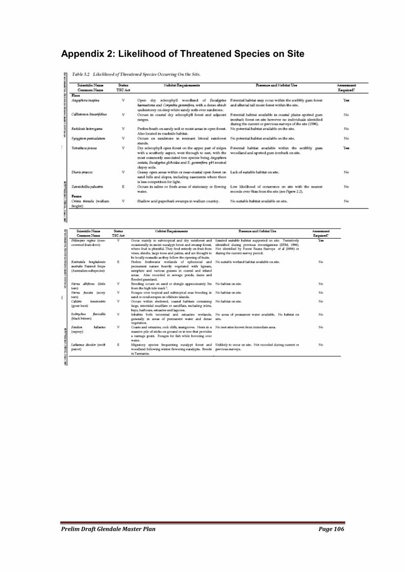
Prelim Draft Glendale Master Plan Page 106
Appendix 2: Likelihood of Threatened Species on Site
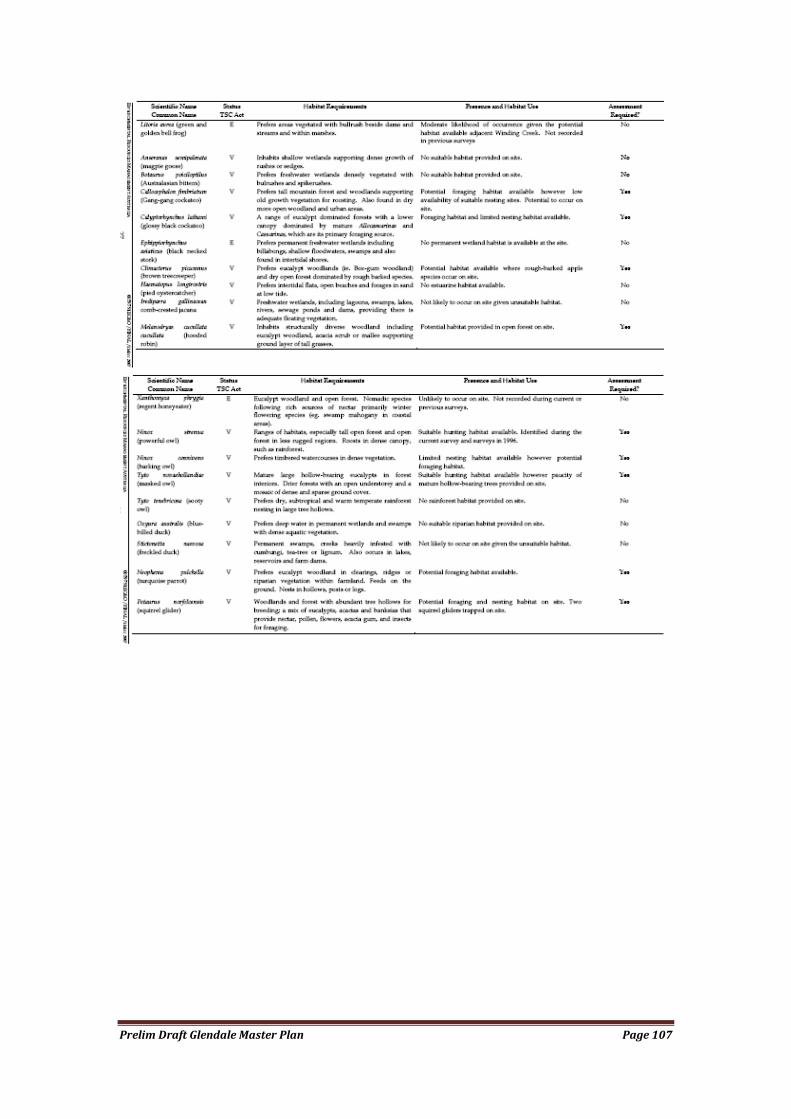
Prelim Draft Glendale Master Plan Page 107