Long-term trends in waterfowl hunters, harvest, waterfowl ...

CHAPTER 4 Waterfronts and Open Spaces
DRAFTFinal ReportJune 2003
90
Existing Open SpacePlanned Open SpaceVision Open SpaceVision for Wetlands along the RiverLandscaped Riverbanks
0 1/4 1/2 1 Mile
KEY CHICAGO RIVER RECOMMENDATIONS
NEAR NORTH10. Add a new boat house, pedestrian bridge and river edge landscape at the North Avenue turning basin11. Enhance landscaping along the west side of Goose Island12. Create a natural habitat and recreation opportunities along the east side of Goose Island13. Ensure continuous river access through the Montgomery Ward site to connect with parks at Hobbie and Erie Streets.14. Create Du Sable Park at the mouth of the Chicago River15. Create an active riverwalk with commercial uses along the north side of the Main Branch from the lake to Wolf Point.16. Create new public space at the Sun Times-Trump Tower Chicago site.17. Create a new public park at Wolf Point.
THE EXPANDED LOOP18. Create a continuous pedestrian riverwalk along Wacker Drive on the Main Branch from Lake Street to the lakefront as part of the Wacker Drive improvements.19. Develop a riverfront plaza on the west bank of the South Branch between Randolph and Lake Streets.20. Develop a public riverfront plaza at 310 South Wacker Drive.21. Create new riverfront open space at the Old Main Post Office along with its redevelopment.
SOUTH LOOP AND NEAR SOUTH22. Create a new riverfront park at Franklin Point.23. Create a continuous public river park on the east side of the Chicago River to provide public access from Harrison Street to Ping Tom Park.24. Expand Ping Tom Park.25. Achieve a continuous open space corridor along the west side of the Chicago River.26. Implement Origins Park plan at the South Turning Basin.27. Expand Origins Park to serve the Bridgeport neighborhood.
The Riverfront Open Space System
Planned, proposed and envisioned riverfront recommendations.
18
15
13
16
10
11
12
22
24
26
20
27
25 23
1417
19
21
Figure 4.3.23The riverfront will become a major new
public amenity on a par with the lakefront.A continuous riverwalk will extend from
outlying neighborhoods through theCentral Area to Lake Michigan
91
CHAPTER 4 Waterfronts and Open Spaces
CHICAGO CENTRAL AREA PLAN DRAFT Final ReportJune 2003
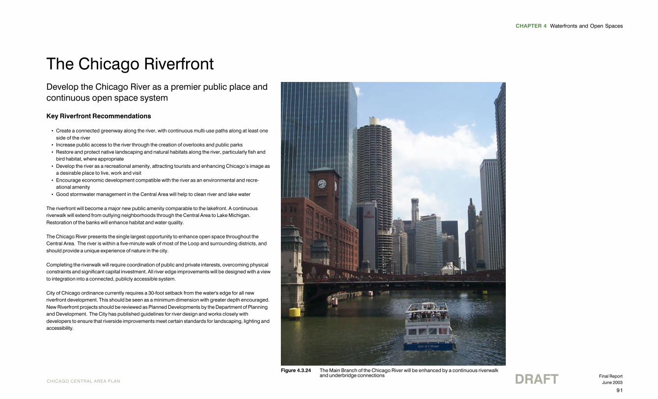
The Chicago RiverfrontDevelop the Chicago River as a premier public place andcontinuous open space system
Key Riverfront Recommendations
• Create a connected greenway along the river, with continuous multi-use paths along at least oneside of the river
• Increase public access to the river through the creation of overlooks and public parks• Restore and protect native landscaping and natural habitats along the river, particularly fish and
bird habitat, where appropriate• Develop the river as a recreational amenity, attracting tourists and enhancing Chicago’s image as
a desirable place to live, work and visit• Encourage economic development compatible with the river as an environmental and recre-
ational amenity• Good stormwater management in the Central Area will help to clean river and lake water
The riverfront will become a major new public amenity comparable to the lakefront. A continuousriverwalk will extend from outlying neighborhoods through the Central Area to Lake Michigan.Restoration of the banks will enhance habitat and water quality.
The Chicago River presents the single largest opportunity to enhance open space throughout theCentral Area. The river is within a five-minute walk of most of the Loop and surrounding districts, andshould provide a unique experience of nature in the city.
Completing the riverwalk will require coordination of public and private interests, overcoming physicalconstraints and significant capital investment. All river edge improvements will be designed with a viewto integration into a connected, publicly accessible system.
City of Chicago ordinance currently requires a 30-foot setback from the water's edge for all newriverfront development. This should be seen as a minimum dimension with greater depth encouraged.New Riverfront projects should be reviewed as Planned Developments by the Department of Planningand Development. The City has published guidelines for river design and works closely withdevelopers to ensure that riverside improvements meet certain standards for landscaping, lighting andaccessibility.
Figure 4.3.24 The Main Branch of the Chicago River will be enhanced by a continuous riverwalkand underbridge connections
CHAPTER 4 Waterfronts and Open Spaces
DRAFTFinal ReportJune 2003
92
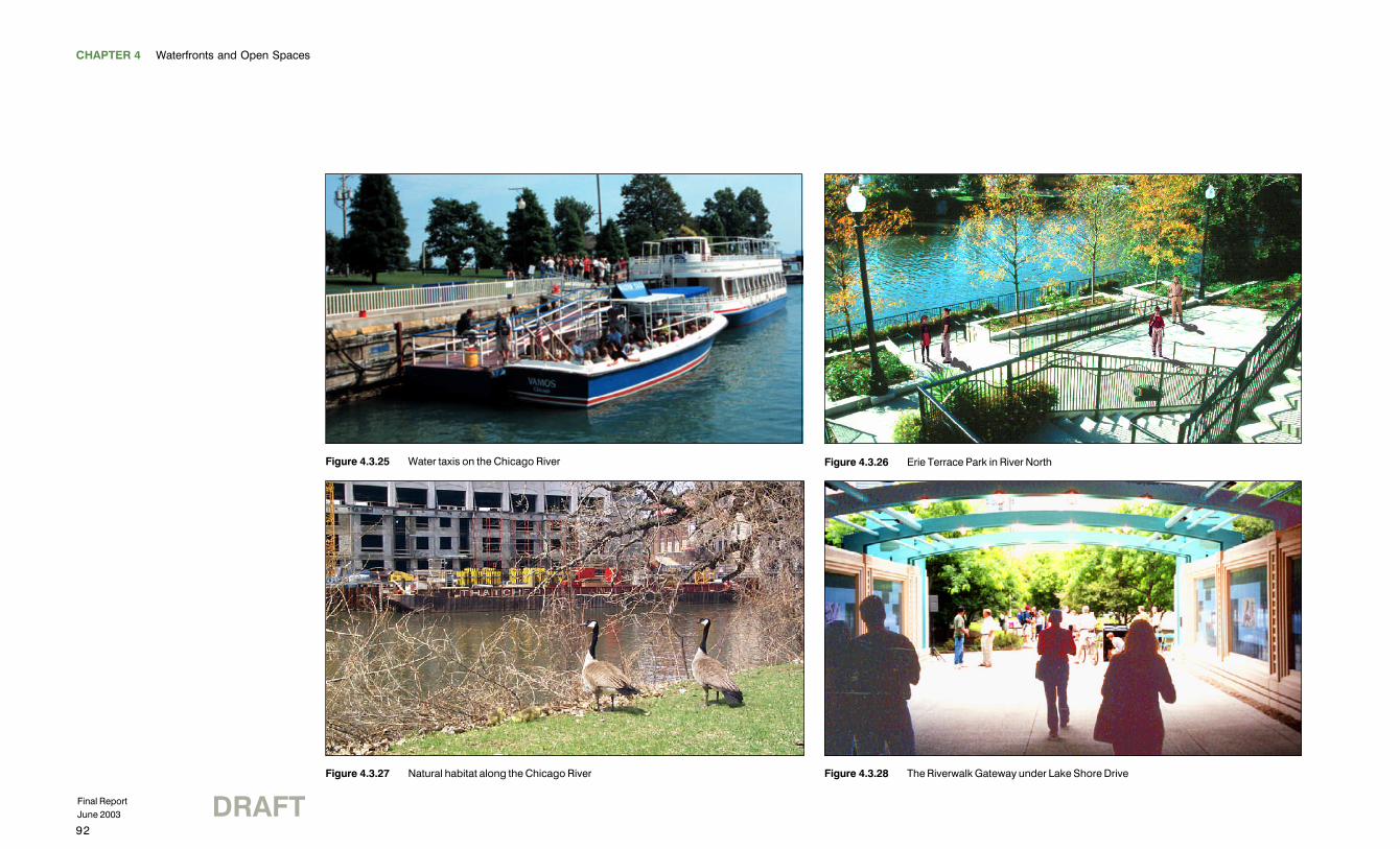
Figure 4.3.26 Erie Terrace Park in River North
Figure 4.3.28 The Riverwalk Gateway under Lake Shore Drive
Figure 4.3.25 Water taxis on the Chicago River
Figure 4.3.27 Natural habitat along the Chicago River
93
CHAPTER 4 Waterfronts and Open Spaces
CHICAGO CENTRAL AREA PLAN DRAFT Final ReportJune 2003
MAJOR COMPONENTS OF THE DOWNTOWN RIVERWALK WILL BE COMPLETEDIN THE NEAR FUTURE
A continuous river path will be located on at least one side of the river throughout the Central Area.This path is envisioned as a multi-use trail suitable for cycling, walking, and other uses. The path willoffer underbridge connections such as those at Lake Shore Drive and Columbus Drive on the MainBranch. These connections make a continuous landscaped path possible, extending from MichiganAvenue to Lake Michigan, with a link to the lakefront bike path at Lake Shore Drive.
On the north bank of the Main Branch, this path will extend west to a multi-level river promenade at theredeveloped Sun-Times site, which will also include access to a transit stop at the new Carroll Avenuebusway. A continuous street level path at Marina City, IBM and Reid Murdoch will provide pedestrianaccess. The path will continue west and provide access to the Merchandise Mart and Wolf Point.Wolf Point affords striking views of the river corridor and provides an opportunity for a significantriverside improvement.
On the south bank, the walkway will continue west along Wacker Drive to Lake Street. The portionbetween Michigan Avenue and Lake Street is envisioned as a grand promenade featuringlandscaping, seating, cafes, performance areas and concessions.
The river walkways are a key element in proposed downtown pedestrian improvements, designed tofacilitate movement of commuters between the West Loop rail stations and their workplaces.Eventually, a continuous street-level riverside walkway will extend along the west side of the SouthBranch between Van Buren and Lake streets, with connections to Union Station and the OgilvieTransportation Center. This walkway will make it possible for pedestrians to walk along the river fromthe train stations to the lakefront by crossing to the Wacker Drive walkway at Lake Street. Thewalkways will also provide stops for the enhanced water taxi system proposed for the Central Area.
THE NORTH AND SOUTH BRANCHES OFFER OPPORTUNITIESFOR MAJOR RIVER ENHANCEMENTS
Several large vacant sites remain along the north and south branches of the river. These sites offeropportunities for regional parks, natural areas and walkways. The redevelopment of the MontgomeryWard headquarters site will provide a continuous riverwalk from a park near Erie Street to a park nearHobbie Street. The eventual development of two vacant parcels will extend the riverwalk north toHalsted Street.
Another opportunity for enhanced trails and parks is provided on the east side of the South Branchbetween Roosevelt Road and Ping Tom Park at 18th Street as part of the South River DevelopmentCorridor.
At the eastern edge of Goose Island, the North Branch Canal can be designed to accommodatenatural vegetation along its edges with an open channel for vessels. This would provide habitat formigratory waterfowl and a new recreational and environmental resource for residents.
Riverfront Projects
NEAR NORTH• A new boat house, pedestrian bridge, and river edge landscape improvements at the North
Avenue turning basin• A new recreational and environmental resource along the east side of Goose Island on the North
Branch Canal• Continuous river access through the Montgomery Ward site from Hobbie to Erie streets, with
parks at Hobbie and Erie• Creation of Du Sable Park at the mouth of the Chicago River• An active riverwalk with commercial uses along the north side of the Main Branch from the lake to
the Sun-Times / Trump Tower Chicago site and points west• A new public space at the Sun-Times-Trump Tower Chicago site• Potentially a new public park at Wolf Point
THE EXPANDED LOOP• A continuous pedestrian riverwalk along Wacker Drive on the Main Branch from Lake Street to the
lakefront• A public riverfront plaza on the west bank from Randolph to Lake• Public riverside open space at the old main post office
SOUTH LOOP AND NEAR SOUTH• A new riverside park at Franklin Point• A continuous public river park on the east side of the Chicago River offering continuous public
access from Harrison Street to Ping Tom Park• Expansion of Ping Tom Park• Possible continuous open space corridor along the west side of the Chicago River• Creation of a neighborhood riverfront park in Pilsen• Extension of the river park system to the southwest into the heart of the City
CHAPTER 4 Waterfronts and Open Spaces
DRAFTFinal ReportJune 2003
94
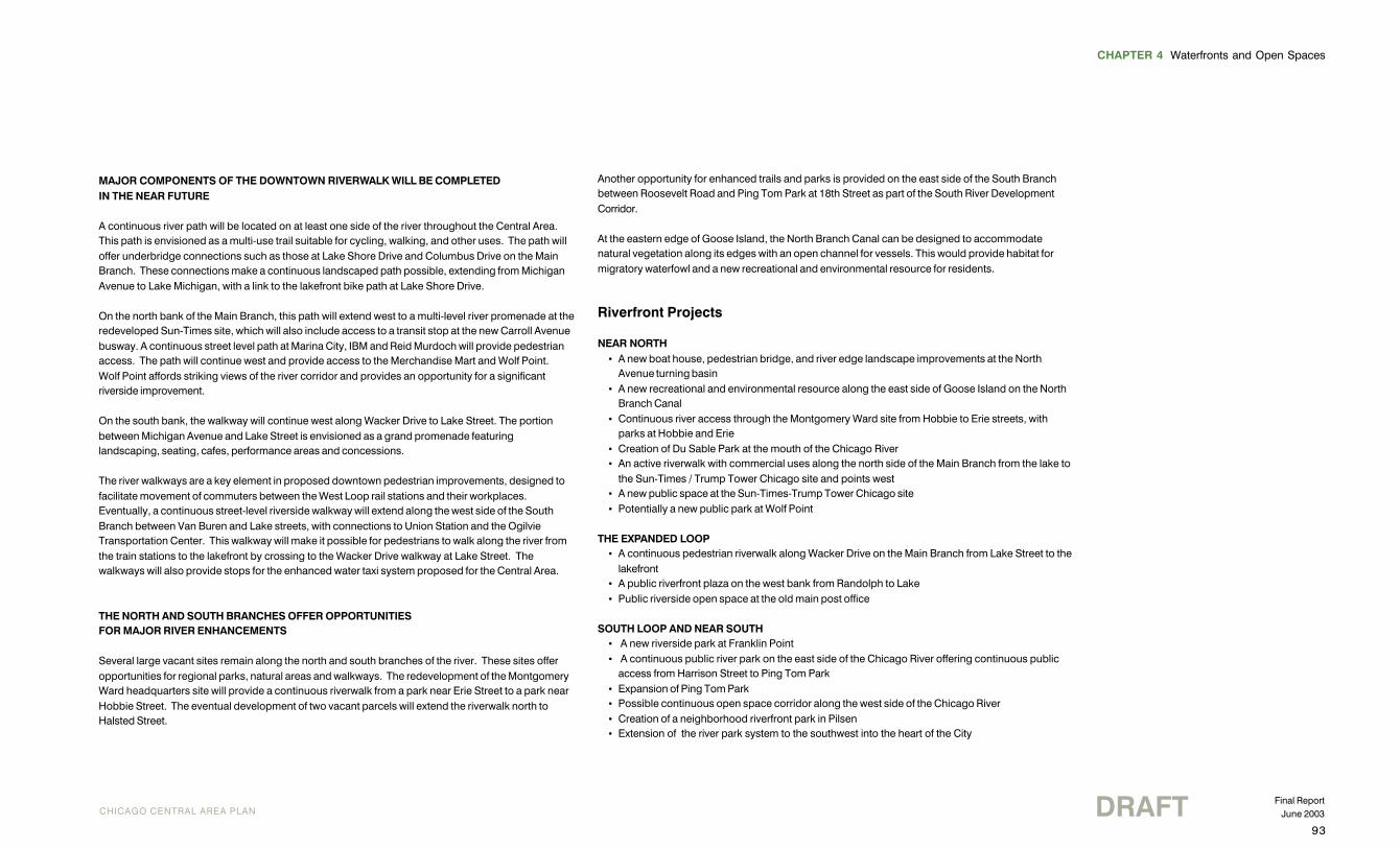
River Parks and the RiverwalkThe River should be seen as a valuable openspace resource as well as a viable transportationcorridor for pedestrians, cyclists and water taxis.
Figure 4.3.29 The South Branch today Figure 4.3.30 The South Branch in 2020

95
CHAPTER 4 Waterfronts and Open Spaces
CHICAGO CENTRAL AREA PLAN DRAFT Final ReportJune 2003
North Branch Canal RiverEdge ImprovementsThe North Branch Canal on the east side ofGoose Island will be transformed, serving asnatural habitat and providing a variety ofecological and recreation opportunities.
Figure 4.3.32 The North Branch Canal todayFigure 4.3.31 The North Branch Canal in 2020
CHAPTER 4 Waterfronts and Open Spaces
DRAFTFinal ReportJune 2003
96
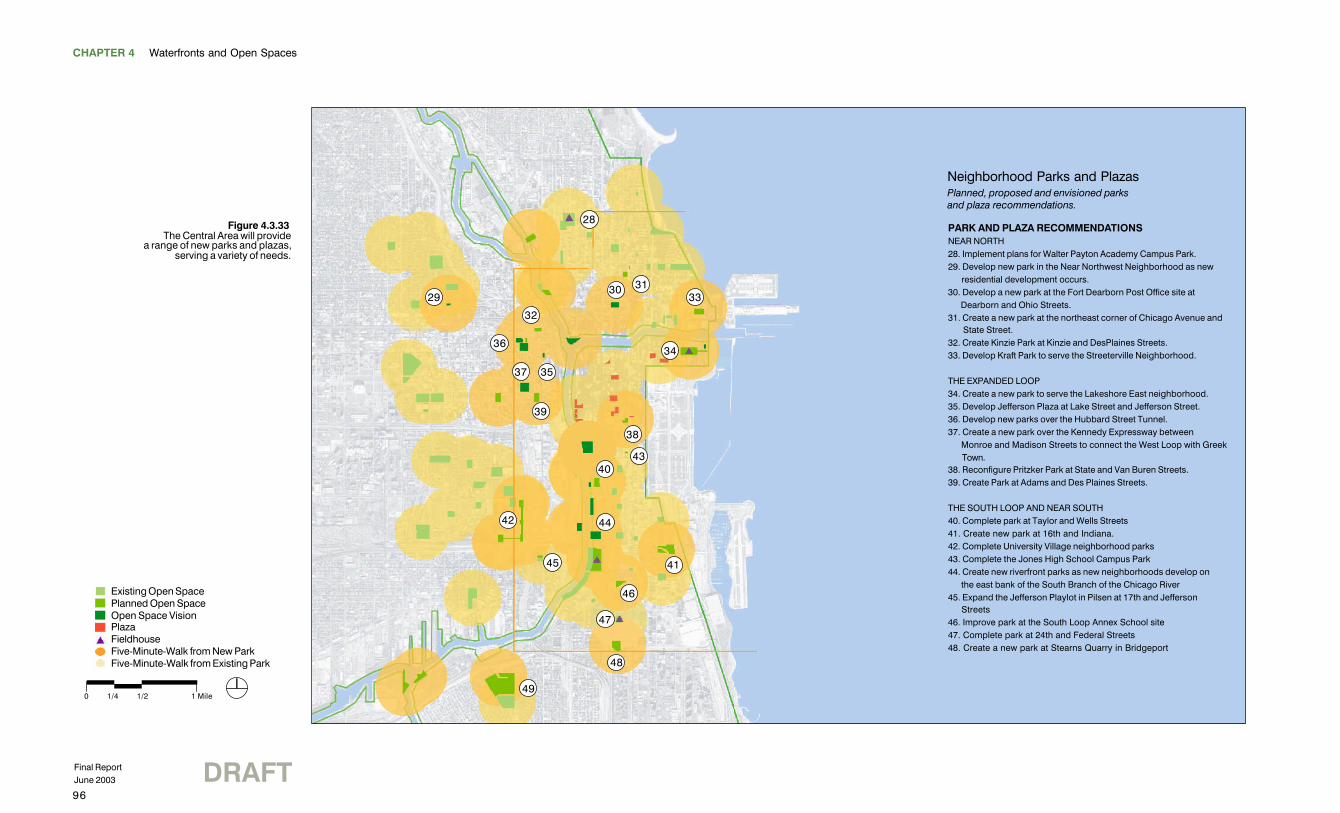
PARK AND PLAZA RECOMMENDATIONSNEAR NORTH28. Implement plans for Walter Payton Academy Campus Park.29. Develop new park in the Near Northwest Neighborhood as new residential development occurs.30. Develop a new park at the Fort Dearborn Post Office site at Dearborn and Ohio Streets.31. Create a new park at the northeast corner of Chicago Avenue and State Street.32. Create Kinzie Park at Kinzie and DesPlaines Streets.33. Develop Kraft Park to serve the Streeterville Neighborhood.
THE EXPANDED LOOP34. Create a new park to serve the Lakeshore East neighborhood.35. Develop Jefferson Plaza at Lake Street and Jefferson Street.36. Develop new parks over the Hubbard Street Tunnel.37. Create a new park over the Kennedy Expressway between Monroe and Madison Streets to connect the West Loop with Greek Town.38. Reconfigure Pritzker Park at State and Van Buren Streets.39. Create Park at Adams and Des Plaines Streets.
THE SOUTH LOOP AND NEAR SOUTH40. Complete park at Taylor and Wells Streets41. Create new park at 16th and Indiana.42. Complete University Village neighborhood parks43. Complete the Jones High School Campus Park44. Create new riverfront parks as new neighborhoods develop on the east bank of the South Branch of the Chicago River45. Expand the Jefferson Playlot in Pilsen at 17th and Jefferson Streets46. Improve park at the South Loop Annex School site47. Complete park at 24th and Federal Streets48. Create a new park at Stearns Quarry in Bridgeport
Neighborhood Parks and PlazasPlanned, proposed and envisioned parksand plaza recommendations.
36
32
31
39
2930
35
33
37
28
34
38
4340
42
45 41
46
48
47
49
44
Figure 4.3.33The Central Area will provide
a range of new parks and plazas,serving a variety of needs.
0 1/4 1/2 1 Mile
Existing Open SpacePlanned Open SpaceOpen Space VisionPlazaFieldhouseFive-Minute-Walk from New ParkFive-Minute-Walk from Existing Park
97
CHAPTER 4 Waterfronts and Open Spaces
CHICAGO CENTRAL AREA PLAN DRAFT Final ReportJune 2003
Parks and PlazasCreate the next generation of urban and neighborhood parks and plazas to support the growing population
Key Park and Plaza Recommendations
• Expand regional parks to better serve Central Area residents• Create new neighborhood parks• Ensure that plazas contribute to the pedestrian realm with landscaping and seating, and are
located appropriately
Regional ParksRegional parks include Ping Tom Park as well as Seward Park just outside the Central Area. Ping TomPark at 18th Street and the Chicago River is being expanded to include a fieldhouse, baseballdiamonds, a soccer field, and river edge connections to the north and south.
In addition, a 5.3 acre park and an adjacent elementary school are planned as part of the LakeshoreEast development. The park will include indoor and outdoor recreational facilities, with fieldhouseservices provided in the school building.
Neighborhood ParksThese parks are intended primarily for nearby residents and workers. New neighborhood parks arebeing pursued at the following locations:
• Kinzie Street and Jefferson Street.• Kraft Building site at Grand Avenue and Peshtigo Court. A two-acre park will be built above an
underground parking lot, helping to ease both open space and parking shortages in the area.• U.S. Postal Service site, Ontario Street and Dearborn Street. A 0.8-acre park serving the River
North community has been proposed for this location. River North currently has no interior parksdespite substantial population growth.
• A park over the Kennedy Expressway at Monroe Street that will connect the West Loop toGreektown and be a civic gateway.
• A West Loop Park at Desplaines Avenue and Adams Street. A 1.2-acre park has been proposedfor this site, currently used as a parking lot. A grade school and numerous apartment buildingsare in the vicinity. The West Loop has been proposed for high-density office development and willrequire adequate open space for workers on their lunch breaks.
• The southeast corner of Taylor Street and Wells Street. This 3-acre site is being reserved inanticipation of residential development in the vicinity.
• 24th Street and Federal Street.
PlazasPlazas serve the Central Area's workers. Although open to the public, in many cases they are actuallyprivately owned and maintained. Many plazas in the Central Area were built under the bonusprovisions of the Chicago zoning code, which permit developers to build larger buildings in return forproviding public amenities. To ensure future plazas and other amenities are of high quality, the zoningcode was recently amended to include design standards for character, size, landscaping, access,location, orientation, seating and lighting. Plazas are prohibited in areas where they would disrupt thecontinuity of the historic street wall such as sections of Michigan Avenue, LaSalle Street and WabashAvenue.