DOCUMENT P7SUME ED 049 151 SP 007 022 AUTHOR Earth … › fulltext › ED048151.pdf · This...
326
DOCUMENT P7SUME ED 049 151 SP 007 022 AUTHOR TITLE INSTITUTION PUB DATE NOTE EDRS PRICE DESCRIPTORS ABSTRACT Eeyer, Frederick Spooner, William Y. Earth Science. In-Seivice Television Program. North Carolina State Board of Education, Raleigh. Dept. of Public Instruction. [70] 325p. EDRS Price MF-$0.65 HC-$13.16 *Curriculum Guides, *Earth Science, Geoloyy, *Inservice Teacher Education, Meteorology, Oceanology, *Physical Geography, ',Se,,:ondary Education, Soil Science GRADES OR AGES: Inservice course for secondary teacners. SUBJECT MATTER: Earth science. ORGANIZATION AND PHYSICAL APPEARANCE: The guide is intended for use with a 32- program television course f)c teachers, with material intended to be used in tne classroom. The introductory material explains the rationale of the course and includes the transmission schedule and bibliography. Each lesson section is divided into four segmentsobjectives, a list of references, suggested activities, and ? content outline of the material. The guide is offset printed and is in a looseleaf binder- OBJECTIVE:. AND ACTIVITIES: The o'cjectives are listed at the beginning of each lesson. Suggested activities arG included in each lesson and are intended to Provide examples of student investigation, demonstrations, or activities which will demonstrate 3 particular concept. INSTRUCTIONAL MATSFIALS: References to relevant printed material are given In each lesson, and other materials ate also referred to in the text. STUDENT ASSESSMENT: No provision is trade for evaluation. (MBM)
Transcript of DOCUMENT P7SUME ED 049 151 SP 007 022 AUTHOR Earth … › fulltext › ED048151.pdf · This...

DOCUMENT P7SUME
ED 049 151 SP 007 022
AUTHORTITLEINSTITUTION
PUB DATENOTE
EDRS PRICEDESCRIPTORS
ABSTRACT
Eeyer, Frederick Spooner, William Y.Earth Science. In-Seivice Television Program.North Carolina State Board of Education, Raleigh.Dept. of Public Instruction.[70]325p.
EDRS Price MF-$0.65 HC-$13.16*Curriculum Guides, *Earth Science, Geoloyy,*Inservice Teacher Education, Meteorology,Oceanology, *Physical Geography, ',Se,,:ondaryEducation, Soil Science
GRADES OR AGES: Inservice course for secondaryteacners. SUBJECT MATTER: Earth science. ORGANIZATION AND PHYSICALAPPEARANCE: The guide is intended for use with a 32- programtelevision course f)c teachers, with material intended to be used intne classroom. The introductory material explains the rationale ofthe course and includes the transmission schedule and bibliography.Each lesson section is divided into four segmentsobjectives, a listof references, suggested activities, and ? content outline of thematerial. The guide is offset printed and is in a looseleaf binder-OBJECTIVE:. AND ACTIVITIES: The o'cjectives are listed at the beginningof each lesson. Suggested activities arG included in each lesson andare intended to Provide examples of student investigation,demonstrations, or activities which will demonstrate 3 particularconcept. INSTRUCTIONAL MATSFIALS: References to relevant printedmaterial are given In each lesson, and other materials ate alsoreferred to in the text. STUDENT ASSESSMENT: No provision is trade forevaluation. (MBM)

V)
US OF.TARTMENI OF HEALTH.EN/CA.710N & WE:JAMEOFFICE OF EDUCATION
THIS DOCLNIENT HAS BEEN REPRO-DUCED EXACTLY AS RECEIVED FROMTHE PERSON OR ORGANIZATION OHIG:HATING IT POINTS OF VIEW OR 0.IN,ONS STATED GO NOT NECESSARILYREPRESENT OFFICIAL OFF/CE OF EDU-CATION POSITION OR POLICY EARTH SCIENCE
IN- SERVICE TELEVISION PROGRAMNORTH CAROLINA DEPARTMENT OF PUBLIC INSTRUCTION /RALEIGH
PREPARED AND PRESENTED BYFREDERICK L. BEYER, PROGRAM DF.VELOPER
WILLIAM C. SPOOUER.PROGRAM DEVELOPER
DIVISION OF SCIENCE EDUCATION

TABLE OF CONTENTS
INTRODUCTIO
A. BibliographyB. Transmission and Lesson Schedule
TELEVISION LESSONS
Lesson 1. IntroductionLesson 2. Concept TeachingLesson 3, The Earth - Member of the UniverseLesson 4. The Earth in SpaceLesson 5. Location and ?laps
Lesson 6, MappingLessor 7. The Atmosphere as a Heat EngineLesson 8. The WindsLesson 9, Clouds and PrecipitationLesson 10. Forecasting the WeatherLesson 11. Cyclonic StormsLesson 12. The Oceans and their CurrentsLessor 13, Bottoms, Waves, and TidesLesson 14. Shore ProcessesLesson 15 MineralsLesson 16. Igneous Rocks and Rock Forming MineralsLesson 17. Extrusive Igneous Rocks and VolcanoesLesson 18. Weathe.^infj
Lesson 19. Erosion and Running WaterLesson 20. Running Water and Land FormsLesson 21. Ground WaterLesson 22. Erosion by Ice and WindLeston 23. DEposition and Sedimentary RockLesson 21 UestrophismLesson 25. Dizst,sophism and the Eerth's StructureLes3on 26. MountainsLesson 27. Plains and PlateausLesson 28. Theories of Crustal MovementLesson 29, Geological TimeLesson 30. Historical GeologyLesson 31. Historical Geology--The Mesozoic and CenozoicLesson 32. North Carolina's Geologic Witory

INTRODUCTION
The purpose o6 th,i4 pubtication id to provide a guide and 4e6eAenceliCIA you, the teacheA, taking thiz in-ae4vice tetevizion comae. The courcze. iz
okgamLzed into thiuy-two programs, each thiAty minutez tong, which witt bebkoadeast Ottowing the achedute on page 3. Thiz guide 4.6 organized in asimitat magnet. Thee ate thitty-two tezaonz, each cotheaponding to a pugum.Each tesaon section id divided into Out segments. The 6iAzt aegment atatezthe object'vez oh_ goai4 which the tezaon hopes to accomptizh. The second is ati.st 06 4e0Aence4, and the thitd ,is a group o6 auggezted activitiez. ThetiouAth iz a content outtine o6 the matetiat to be discuaaed in that tezaon.
The Reieunce Section:
Eacn tozon 4e6eitenced in aevutat texas. Whenevet pozaibte, attth4ee atate-adopted texta ate cited 6iAat and in the Got owing otdet:
1. Vibba, AtbeAt R. and AtbeAt F. Ei46. THE EARTH-SPACES7ZENCES (Laidtaw Skothem, 1969).
2. Bi4hop, MaAganet S., Phyttiz G. Lewiz, and Richmond L. 6tonaugh.FOCUS ON EARTH SCIENCE (Memitt, 1969).
3. Earth Science Cuv.icutum Prefect. INVESTIGATING THE EARTH(Hovyhton Mi66tin, 1961) .
The okda 24 not intended to convey any p4e6e4ence but simpty to atandakdizeand, .thus, zimptiiy the pkoceza o6 6-Li ding the panties can Aelieunct yoo areseeking. Pkincipat aupptementaAy 4e6mencez are at-5o given 604 each tezaon.Again, the otdet means titte4.; kathe4, the aou4cez cited kepiceaent the beatv6 the aou4cez avaitabte to the autlzok at the time o6 w/Liting. Ad completea bibtiogtaphy as poaaibte id .included at the end 06 this section. In theevent that a 4e0Aence 24 patticutatty vatuabtc, it usuatty witi be mentionedon the ptogtam preceding the one to cehich it apptiea.
The Activitiez Section:
The pAincipat puvoae o6 the activitiez section 24 to ptovide youwith some examples oi student iweatigationa, demonattationz, Oh activitiezKhich Lead into Oh aekve to demonztAate a paitticutaA conceyt. Them aretat/catty hundreds 06 poasibte activit<lez, and there is apace in thia hand-book 6ot only a Ow. AA time peArtitz, more witt be added and disthibutedto you. 16 you know o6 a demonattation, inveztigation, or activity which -4not eated, ptecoe let us know ao that we may add it to OWL bats and inlioAmthe otheA teacheAs taking the comae.
Do not beet that you mw .t tAy every activity tinted, but do Pty atleast one eveity a'ce's. One oti the beat ways to keep atudentz awake, intekeated,and enthuaitia,Uc id to keep then busy diacoveg. Most o6 the activitiesahown promote discovery and, theice4me, can make teakning an exciting buainers.

INTRODUCTION, Page 2
The Content ()Wine:
This pottion o6 the handbook iz perhaps the teazt vatuobte. Fitzt,rang o6 the 6act5 tzted wilt have changed belote the coutze L compteted.Mote. impottant ate the motet conceptz embodied in the outtine. We ate, a6tetatt, ptincipatty intetezted in conceptz. You 4houtd tuat the outtine as youwould a zet o6 coutze notez. Indeed, they ate intended to zetve as ouch, andwe hope you witt use them in ptace .94 taking noted. You zhoutd beet 6tee tomatk out, add to, make nvtez en, of zutibbte ate. °vet the entite handbook. Itbeeongz to you. The teteviziK ptogtam witt not necezzatity covet aft o6 thematetiat inta outline. of take it up in the auttine otdet. However, thematetiat in the tezzon iz vitae to the conceptz being conzideted and, hope4uety,conztitutez a total. eatth zcien.2.e comae when taken as a complete unit o6shinty -two tezzonz. Thoze aativftiee ptinted in their eattety ate not copy-tighted and were purposely ptintcd in a manner as to make them eazity copied.Pteaze beet 6tee to do zo.
Teacher Patticipution:
Me coutze can give you any mote than what you put into it, Webelieve that eolith zcience can be one o4 the moat exciting couAzez in thecutttcutum. We hope yc!L ccitt Sind the teteviz.ion portion inteAezting,ztimutating, and entettaining; '.:ut what you de/Live 6tom the coutze tierdepend ptincipatty on the amount oi energy you expend on the 4ottow-upactivitiez. The zuccezz oi thi.) course depends on you. We hope you wietkeep uz make it the hind o6 succeed it can be.
It

INTRODUCTION, Page 3TRANSMISSION SCHEDULE*
1970 - 71
Program Number Tuesday 4:00 p.m. Thursday 6:30 p.m.
September 15 September 1724
-October2 22
29 1
4 October 6 8
5 13 15
. I 22,--..-
7 27 29
8 November 3 November 5
9 10 12
0 17 19
THANKSGIVING THANKSGIVING11 December 1 December 3
0---12 a-1-3 15 17
CHRISTMAS CHRISTMAS
14 January 5 January ---7---
15 12
16 19 21
17 26 28
18 February 2
9
February 4
1119
20 16 18
21 23 25
Marc22 March 223 9 11
24 16 T825-
April 1
25 23
26 --TT27 April 6 EASTER
EASTER 15
28 20 22
27 29
30 IET- 4 May 6
31 11 13gr32 1-8
* The same lesson will be broadcast on Tuesday at 4:00 p.m. andThursday at 6:30 p.m. for convenience in scheduling.
kJ

INTRODUCTION, Page 4
TEXT REFERENCES
1. Hibbs and Eiss. THE EARTH-SPACE SCIENCES (Laidlal,2. Bishop, Lewis and Bronaugh. FOCUS ON EARTH SCIENCE (Merrill).3. ESCP, INVESTIGATING THE EARTH (Houghton Mifflin),
ADDITIONAL REFERENCES
4. Namowitz and Stone. EARTH SCIENCE, THE WORLD WE LIVE IN (Van
Nostrand).5. Navarra and Strahler. OUR PLANET IN SPACE (Ha,pei and Row),6. kamsey and Burckley. MODERN EARTH SCIENCE (Holt, Rinehart and
Winston).
7. Ramsey, et al. FOUNDATIONS OF PHYSICAL SCIENCE (Holt, Rinehartand Winston):
8. Thurber and Kilburn. EXPLORING EARTH SCIENCE (Allyn & Bacon).
9. Trinklein and Huffer. MODERN SPACE SCIENCE (Holt, Rinehart andWinston).
10. Wolfe, et al, EART,i AND SPACE SCIENCE (0 C_ Heath).
COLLEGE LEVEL REFERENCES
11, Clark and Stealin. THE GEOLOGICAL EVOLUTION OF NORTH AMERICA
(Ronald).12. DICTIONARY OF GEOLOGICAL TERMS, AGI (Dolphin).
13. A DICTIONARY OF MINING AND RELIVED TERMS, Department of theInterior.
14. Dunbar, HISTORICAL GEOLOGY Niley),15. GEOLOGY AND EARTH SCIENCES SOURCEBOOK, 4G!, (Holt, Rinehart
and Winston).16. Gilluly, et al. PRINCIPLES OF GEOLOGY (F,eeman).17. Holmes. KINZIPLES OF PHYSICAL GEOLOGY (Ronald.,18. Shelton. GEOLOGY ILLUSTRATED (Freemen)19. Shepard, THE EARTH BENEATH THE SFA (Johns HoWns)20. Spencer. GEOLOGY: A SURVEY OF EARTH SCIENCE (C!owell).21. Strahler. EARTH SCIENCES (Harper & Rcwl.22. Strahler. PHYSICAL GEOGkAPHY (Wiley),23. lumberge. ELEMENTS OF GEOLOGY Wi,iey?
NORTH CAROLINA
24. Broadhurst. AN INTRODUCTION TO THE TOPOGRAPHY, GEOLOGY, ANDMINERAL RESOURCES OF NORTH CAROLINA ( Educational Series No, 2,
1952).25. Stuckey. NORTH CAROLINA - ITS GEOLOGY AND MINERAL RESOURCES
(1965).26, Stuckey and Steel. GEOLOGY AND MINERAL RESOURCES Of NORTH
CAROLINA (Educational Series No, 3, 1953!
* Available from North Carolina V.;si:n of Mineal Resources,Department of Conservation and Development, Raleigh, NorthCarolina 27603.

LESSON 1, Introduction
CONSTRUCTS FOR TEACHING EARTH SCIENCE
Oblectives:
To gain an understanding of some of the various approaches that can be usedin teaching earth science and the reasoning behind their application.
2. To differentiate some of the various styles of teaching and their positiveand negative points.
3- To establish a partial constructural base for the organization of thefollowing thirty-one lessons.
References:
1. Hibbs, Albert R , and Albert F. Eiss THE EARTH - SPACE SCIENCES (LaidlawBrothers, 1969), Chapters 1 and 2
2, Bishop, Margaret S., Phyllis G Lewis, anci Richmond L- Bronaugh- FOCUS ONEARTH SCIENCE (Merrill, 1969), pages iii and iv; Chapter 1, Section 1.1,
3. Earth Science Curriculum Project. INVESTIGATING THE EARTH (Houghton Mifflin,1967), text preface and prologue, Teacher's Manual Introduction, pages 1-16.
Activities:
1, Make a list of all the various constructural schemes for teaching earthscience that you can think of- Have each teacher select one and discussits good and bad points. (Example. compare the three constructuralschemes in the state adopted textbook or some of the references.)
2. Have each teacher develop a plan for their year's activity based on one ormore construct, discuss and justify their plan to the rest of the group.
3. Discuss th? approach you plan to use in teaching earth science this year-Will it be factual, investigative, field oriented, concept oriented, ora mixture of the different approaches? Why did you choose your particularapproach?

LESSON 1
CONSTRUCTS FOR TEACHING EARTH SCIENCE
I. Major Construction Themes
A. Classical approach - proceeds systematically through the branches ofthe earth sciences and usually the sub-branches.
Example: Astronomy
Meteorology
Climatology
Oceanography
Geology
{MineralogyPetrologyGeomorphologyStructural GeologyGeophysicsHistorical
B. Historical approach - usually begins with the origin of the universeand continues to the present, inserting other concepts where theybecome necessary to explain events as they develop.
C. Macro to micro - proceeding from the universe to the atom.
D. Micro to macro - proceeding from the atom to the universe.
E. Through the spheres - proceeding from the exosphere to the atmosphere,hydrosphere, and lithosphere or the reverse order.
F. Concept oriented approach - involves selecting the major conceptual baseson which the science functions.
Example: Interface concept Density Evolution
Gravity Time Uniforitarianism
Energy flow Space Isostasy
II. Shotgun or topic selection?
A. Try to cover everything? This usually results 'n poor coverage of manythings and often the end of the school year arrives with material leftuncovered.
B. If you can't cover it well - don't try to cover it at all. Manyteachers feel that it is better to skip a topic rather than treat itpoorly. Often entire subject areas are ignored for one or more of thereasons below.
1. Lack of knowledge,
2, Lack of resources.
3. Lack of interest (either teacher or students).

LESSON 1, Page 2
4. Previous knowledge on part of students (example: space science).
5. Location (example: students in the mid-west often talk more about
fossils and less about oceanography. Students in th? south have
little need for a comprehensive knowledge of the landforms causedby continental and valley glaciers.)
9

LESSON 2 Introduction and Content
TEACHING THROUGH CONCEPTS A% INVESTIGATIONS
Objective: To develop a rationale for teaching so;ence concepts.
References:
Mager, Robert E. PREPARING INSTRUCTIONAL OBJECTIVES (Fearon Publications,Palo Alto, California).
Sund, Robert I., and Leslie W. Trowbridge. TEACHING SCIENCE BY INQUIRY INSECONDARY SCHOOLS (Charles E, Merrill Books, Inc. Columbus, Ohio).
Romey, William D. INQUIRY TECHNIQUES FOR TEACHING SCIENCE,(Rrcntice H011).
Activities:
Discussion should follow the television program. Tae television programwill close out with a 10-minute film, "Toward Inquiry." It is hoped thatthe program (with film) will show the value of teaching concepts throughstudent activity or inlJiry.
Each teacher might examine and L',..cuss the following questions:
1. Do you consider your teaching effective?
2. Is there room for improvement in your teaching?
3. Why do you teach the way you do?
4. Now could you improve your teaching methods?
5. If you are aware of areas for improvements, what factors haveprevented you from implementing these changes in teaching?
6. How can you and your school proceed to overcome these problems.
10

LESSON 3, Introduction
THE EARTH - MEMBER OF THE UNIVERSE
Objectives:
1. To locate the earth as a body in space.2. To develop a concept of the relation between the solar system and the
galaxy.3. To develop a concept of the relationships of the members of the solar
system.
References:
1. Hibbs, Albert R., and Albert F. Eiss, THE EARTH - SPACE SCIENCES(Laidlaw Brothers, 1969), Chapters 3, 4, and 5.
2. Bishop, Margaret S., Phyllis G. Lewis, and Richmond L. Bronaugh.FMJS ON EARTH SCIENCE (Merrill, 1969), Chapter 21.
3. Earth Science Curriculum Project. INVESTIGATING THE EARTH (HoughtonMifflin, 1S't67), Chapters 23, 25 and 26.
Special Reference: Trinklein and Huffer. MODERN SPACE SCIENCE (Holt,Rinehart & Winston, 1961).
Activities:
1. A scale model of the solar system.ESCP Investigation 23-4 Text 501-502
Teacher's Manual 633-635
2. Measuring the diameter of the sun.ESCP Investigation 24-10 Text 530
Teacher's Manual 660-662
3. Investigating galaxies.ESCP Investigation 25-7 Text 547-548
Teacher's Manual 677-679
4 Gravity and inertia must be in balance in order for a planet or satelliteto stay in orbit.
Materials: a piece of strong string about 5 feet long3 or 4 heavy flat washersa spool (or short length of glass tubing)a rubber stopper (or some other heavy but soft object)
Pass the string through the spool, attach the washers to one end of thestring and the stopper to the otler (see illustratidn). Holding thespool above your head, twirl the stopper et proper speed so that the balland weight balance each other. Let the string represent the force ofgravity attracting the planet (stopper) to the sun (spool). Now twirlthe stopper with greater force and observe that the stopper moves outward.
1i

LESSON 3, Introduction, Page 2
As the demonstration is performed, raise the following questions: (l)
What happens to the period of revolution of the stopper as the radius ofthe string becomes greater? As the radius of the string becomes less?(2) What would happen if the string were to break while revolving aboutyour head? Why would this occur?
Relate this demonstration to Kepler's third law, the more distant aplanet is from the sun, the slower it travels in orbit about the sun.Suggest a comparison with Newton's law of gravity: as the distanceincreases between objects, the gravity decreases, thus the slower orbitalspeed. Point out one important difference between our analogy and planetsin motion about the sun. There is a mechanical connection, the string,between your hard and the stopper you are twirling. There is no mechanicalconnection between the sun and the planets.
.5.poo/
sher
S t op/o e r

LESSON 3
THE MTH - MEMBER Oi THE UNIVERSE
I Sun is just one of about 100 billion stars in a galaxy called The Milky Way.There are more than 1 billion galaxies within reach of the 200-inch HaleTelescope and many more than that in space.
A. Galaxies are classified according to their appearance.
1. Irregular - As name implies, they have irregular boundaries. Thereare great quantities of gas and dust. Some appear to be rotatingand have th, beginning of arms. Most stars in these galaxies arelarge and appear youthful.
2. Spiral galaxies - Have one or more spiral arms rotating about arelatively dense nucleus. Stars in the central hub are thoughtto be older than those in the spiral arms.
3, Elliptical galaxies - Are symmetrical and range from ellipsoidsor disks to spherical in shape. There is little dust or gaspossibly because the material has already been formed in the stars.
II. Our own Milky Way Galaxy appears as a band of light across the sky.
A. A spiral type galaxy (diagram). Diameter 80,000 light years
Model: 1 inch = 1 light year
Average staro ;s re. m e 2-3 in,
Ar.cir nic al cc gala, y -20 miles-- neva NI visible only n.s a small
h'.,r w;thotit a telescope.
Pier. tStars More Closely
Roc eft Nere
4'; km! r-t< Vm;(Every star which can be seen with the naked eye as a single pointof light is in our own galaxy. Only the largest telescopes canpick out single stars in other galaxies.)
B. Closest star distance from eart;1 in galaxy Alpha Centuri (4.3 lightyears).
C. The sun is about 2/3 of the way out from the center of the galaxy.
1. The sun and its solar system are traveling about th:. galacticcenter at a velocity of 500,000 mi/year.
2. One complete trip around the galaxy requires 250 million years.
13

LESSON 3, Page 2
The Solar System
A. Our solar system consists of nine planets, comets, asteroids, meteorites,dust particles, electric fields, magnetic fields, and light all moving
about the sun. The Egyptian astronomer Ptolemy devised the first solar
system in 13G A.D. The Ptolemic Universe was earth centered--earth wasfixed, and the seven known planets were assumed to travel around the
earth in circles called deferents. The planets moved in circles called
epicycles which traveled along the deferents. Those were used toexplain retrograde motion in the planets. As time went on, the system
increased in complexity as individuals attempted to explain variousmotions until the system became extremely complex.
Copernicus (16th century) proposed a sun-centered universe. (This had
been done much earlier but was not accepted Greek scholar Aristarchus
of Samos, 3rd century B. C.)
B. The sun is an "average" star.
1. Radius = 696,000 (6.96 x 10⁵) Km.
2. Mass 1.99 x 1030
Kg or 332,000 times that of earth.
3. Thermonuclear fusion provides the energy which makes life possible
on the earth.
C. Planets
1. Mercury a.
b.
c.
Smallest planetClosest to sun (35,000,000 miles)Rotates every 58.65 earth days; revolves aboutsun (Lice every 88 days. (Until 1965 Mercurywas thought to rotate and revolve cnce every
d.
e.
f.
88 days. Then Rodas' observation proved thatthe rotation required only 2/3 revolution.)No atmosphereSun-facing surface temperature (340 °C; 569
oF)
So small, gravity is only 3/8 that of earth
2. Venus - a.
b.
c.
d.
Second planet out from sun (67,200,000 miles)Earth's closest neighbor (26,000,000 miles)Cloudy atmosphere, no oxygen (72 - 98% CO2;atmospheric pressure 7 - 15 times that ofearth)Temperature varies from 45°C (114°F) to 280
oC
e.
f.
(536F)Rotates clockwiseonce every.243 earth daysYur is 224 earth days
3. Earth 3. Third planet out fraJ sun at a mean distance of
b.
9.2,000,000 milesAverage temperature 56°F.
1 ,1

LESSON 3, Page 3
c. Day - 24 hoursd. Year - 365 dayse. One natural satellite
4. Mars - a. 4th planet out (142,000,000 miles)b. Rotates every 24 hours, 37 minutes, 22.1 secondsc. Revolves 687 earth daysd. Temperature range - 70°C (-100°F) - +31°C (+80°F)e. Atmosphere mostly CO2; surface pressure 3/4 that
of earthf. No magnetic field
5. Asteroids - fragments ranging from dust size to 480 miles indiameter.
NOTE: 1 - 4 Inner planets
6. Jupiter - a. Mean orbital distance 484,000,000 milesb. Volume 1,300 times that of earthc. Density 1/4 that of earthd. Atmosphere - hydrogen, methane and ammoniae. Gravity at surface is 2.5 times that of earthf. Rotates wire every 9 hours, 50 minutesg. Revolves 11.9 earth yearsh. 12 known moonsi. Thought to be composed largely of liquid and gas
7. Saturn - a. 889,000,000 miles from sunb. Revolves once every 291/2 earth years
c. Rotates once every 10 hours End 14 minutesd. 95 times larger than the earthe. Rings (171,000 miles in diameter and 10-20 miles
thick
f. Has 10 moons
g. Atmosphere - surface cloud coveredh. Composition probably mostly gas
8. Uranus - a. Composed primarily of gasb. Diameter 4 times that of earthc. 1,784,000,000 miles from sun
d. Revolves once every 84 earth yearse. Rotates once every 10 hours and 49 minutes
f. Axis of rotation lies in orbital plane
9. Neptune - a. 2,800,000,000 miles from sun
b. Orbits once every 165 yearsc. Diameter 28,000 miles, density 0.4 x earthd. Composition gaseo6se. 2 moons
10. Pluto - a. Discovered 1930b. Diameter estimated 36,000 milesc. Orbit varies from 2,700,000,000 miles perihelion
to 4,600,000,000 miles apheliond. Orbit requires 248 years

LESSON 3, Page 4
D. Plane of Rotation
The planets of the solar system all revolve in a band which variesfrom a perfect plane by a maximum of 7° with the exception of Pluto.Thus, they move in a band of sky known as the Zodiac.
1. Constellations found along band known as Zodiac:
a. Aquarius g. Leo
b. Pisces h. Virgoc. Ariel i. Libra
d. Taurus j. Scorpiuse. Gemini k. Sagittariusf. Cancer 1. Capricornus
E. Ecliptic is the path along which the planets appear to travel on thecelestial sphere.
di.a.t., p ,e- . , ,,,,,,t,:x.,_ b;tal path
/7/7 //7!' t .t /
4,%. 4% 6.'2/
;7'' Yr r ,,
7 'r" ; .-/
.,- .
,--ze'--'
Celestiill sphere - A sphere of infinite radius with all the starsexcept the sun located on its surface.
Celestial equator- A projection of the earth's equator on thecelestial sphere.
Celestial poles - The projection of the N and S poles on thecelestial spheres.
CelestralspAere
Pane fa(
Celestial Aloft h Pole
4-
_
EarthV
1G
Zodiac Bandwithin whichplanets appear.

LESSON 4, Introduction
THE EARTH - PLANET IN SPACE
Objectives:
1. To understand the motions of the earth.2. To develop a concept of seasons on the earth as they are related to motions
in the solar system.3. To develop a concept of time as a function of rotation.4. To comprehend the dimensions of the planet.
References:
1. THE EARTH - SPACE SCIENCES, Chapter 12, pages 220-2262. FOCUS ON EARTH SCIENCE, Chapter 1, pages 4-12; Chapter 2, pules 24-353. INVESTIGATING THE EARTH, Chapter 3, pages 58-80 (Teacher's Manual 92-
119); Chapter 4, pages 82-102 (Teacher's Manual 120-145)
Special References:Strahler. PHYSICAL GEOGRAPHY (John Wiley & Sons, Inc., 1961), Chapters
1, 4, 5, 6Trinklein and Huffer. MODERN SPACE SCIENCE (Holt, Rinehart & Winston,
1961), Chapter 4
Activities (involving equipment):
1. Show the earth's rotation by means of the Foucault pendulum.
Materials: heavy metal ball (such as a 16 lb shot)long wire (15 or 20 feet)steel hooksuspension bracketroom with high ceiling (gymnasium or auditorium)Hook mounted on the wall
The heavy ball is to be hung at the end of the long wire, from asuspension bracket in ceiling. The steel hook must be sharpened andrest in a depression ground in the bracket cs sketched below. Pull
the pendulum aside and tie it by a fine thread to a hook in the wall.When it has become perfectly still, burn the thread. This releasesthe pendulum without any disturbance. The pendulum will continue toswing while the room turns because of the earth's rotation. Since thesupport is practically frictionless, the rotation of the room is notcommunicated to the pendulum. In the northern hemisphere the southend of the swing will gradually shift westward, and the change can benoted in half an hour or more. Care should be taken that no aircurrents disturb the motion.
The significance of this experiment can be explained by mounting asimple pendulum on a rotating stool. Any small heavy object can besuspended from a clamp mounted on a stand which is set on the stool.Start the pendulum swinging, and then turn the stool under it. The
pendulum keeps swinging in same plane, which does not change whenstool and pendulum support rotate.

LESSON 4, Introduction, Page 2
cer"Heavy we/yht
This investigation can be simulated by demonstration. The materialsrequired include a rotating platform (piano stool, etc.), wastebasket,stick, string, and a small heavy weight. Place the empty wastebasketon the seat of the rotating piano stool. Tie a string to the weightand fasten the other end to the stick. Place the stick across the topof the wastebasket and start the pendulum swinging. Then rotate thestool seat along with the basket. Notice that the path of the pendulumdoes not change as the basket turns.
2, Investigating motions in the skyESCP Investigation 4-1 Text 84
Teacher's Manual 123-126
3, Investigating positions on a sphereESCP Investigation 3-2 Text 63
Teacher's Manual 96-99
4. You can measure the earthESCP Investigation 3-5 Text 68-69
Teacher's Manual 102-106
Activitit: (involving little or no equipment):
1. Determine the apparent rotation of the sky due to the earth's rotation.
Materials: star chartplumb line (string and weight). Instead of the plumb line,
the vertical edge or corner of a building will serve verywell, if such is available. Do not use posts or telephonepoles; they may not be exactly vertical.
pencil and paperwatch or clock
a. Choose a location from which the whole northern sky is visible,including parts close to the horizon. Identify the North Star(Polaris), Big Dipper, and Cassiopeia. Holding the plumb linesteady at arm's length so that it seems to pass right throughPolaris, observe carefully where its lower end appears against thestars of the Big Dipper or Cassiopeia (or between them). Draw a
line on the star chart to represent this position of the plumb
1.;

LESSON 4, Introduction, Page 3
line, and note the time to nearest minute. Make the same type cfobservation two or three hours later, mark lines on chart, and notethe time. Also record the calendar date. In which direction doesthe sky appear to turn? (Clockwise or counterclockwise?) Relatethis to the earth's rotation: if you looked down on the north poleof the earth, how would the earth seem to turn? (Clockwise or counter-clockwIse?)
Measure the angle between the two lines with a protractor. How manydegrees is it? Calculate the change in degrees per hour. From this,calculate the time required for one complete rotation (3600). Whatconclusion can be drawn from this result? How accurate do you thinkyour result is? This observation may be supplemented by photographicstar trails.
b. Stand in a particular spot that can be exactly identified later.Identify one of the prominent constellations in the southern sky (e.g.,Orion) and sketch its position relative to prominent landmarks(buildings, trees, etc.). Note the time. Two or three hours later,standing at exactly the same spot, again observe the same constellation,sketch its position, and note the time. How does the change of positionof this constellation fit in with the change you observed in the north?Would its period for one complete rotation differ from that of thenorthern sky?
c. Observe a constelladon that appears low in the eastern sky, andobserve it two hours later. Explain the changes.
d. Observe a constellation that is about midway up in the western sky,and observe again two hours later. Explain the changes.
2. Drawing the earth to scale ES, Text 73Teacher's Manual 107
3. Spinning bodies precess on their axes. Obtain a smell toy gyroscope orwooden top. Start the top or gyroscope spinning and place on any flatsurface. Notice as the spinning slows that the axis will begin to wobbleor precess.
4. Using your school flagpole or any other tall slender object, record theshadow made on the ground at noon several times a month during the schoolyear. (See Strahler, PHYSICAL GEOGRAPHY, pages 87-88.)
10

LESSON 4
I. Motions of the Earth
A. The earth's Notions can be summarized as follows:
1. The sun and its solar system move with the galaxy and rotateabout the galactic center.
2. The earth revolves about the sun.
3. The earth rotates and precesses on its axis.
B. We have discussed the path of the sun in the galaxy and it can besummed up as being located about 2/3 (27,1000 light years) of the wayout from the center of the galaxy and traveling about that centerat a speed of 220 Km/sec (136 mi/sec). Therefore, it takes about220,000,000 years to complete one revolution about the galactic center.
C. The revolution of the earth about the sun enables us to determine ayear.
1. Because of the tilt of the earth's axis the seasons occur.
a. The tilt of the earth's axis is 23141 to the orbital plane.
b. The tilt is always the same--the North Pole is always orientedtoward the pole star, Polaris.
VerricAl eq.41144,x. rareh 2/
June 2i5,,,,,Imer solstice
Itt-zsi°,1
sugkteo
San
go.
Circle
DecernAer 22Winter joistice
if
5epte n, be r 23Autumnal egtir.lnox
2. On Mama 21 (vernal equinox) the sun first shines on the NorthPole.
a. The sun is directly overhead at the equator.
b. Until September 23 the sun will be seen directly overheadnorth of the equator.
3. On June 21 (summer solstice) the sun reaches the lost northwardposition w'oere it is Directly overhead.
a. Tnis i; located at 231,' north latitude and is calledthe of Cancer.
b. At any point horn of the ir:)pic of Caocer, the sun will alwaysbe see:i in tie southern part of tie sky.

LESSON 4, Page 2
c. The sun does not appear above the horizon within the AnarcticCircle on this day (661/20 south latitude).
4. On September 23 (autumnal equinox) the sun has returned to a positiondirectly overhead at the equator.
a. The sun will now be seen for the first time at the South Pole.
b. The sun is not now visible from the North Pole.
5. On December 21 (winter solstice) the sun is directly overhead atthe Tropic of Capricorn (231/2° south latitude). This is the farthestpoint south of the equator at which the sun will be seen directlyoverhead.
a. At the time of winter solstice, the northern hemisphere receivesthe least heat from the sun.
h. The lowest winter temperatures occur after this date because ofthe "lag" in heating and cooling of the earth.
c. Sun does not rise on this day within the Arctic Circle (661/20north latitude).
6. The length of time from one vernal equinox to another is known asa Tropical Year (365 days, 5 hours, 48 minutes, and 46 second:).
D. The rotation of the earth on its axis establishes a measure of timecalled a day.
1. The earth rotates 360° in 24 hours.
a. 360° divided by 24 hours equals 15° per hour.
b. Thus an hour is equal to rotating 150 or traveling around theearth to a point 15° east or west of the starting location.
IS"
c. Since the earth rotates from west to east time progresses fromeast to west.
3 4d. The contiguous United States has four time zones.
(1) Eastern Standard Time(2) Central Standard Time

LESSON 4,, Page 3
(3) Mountain Standard Time(4) Pacific Standard Time
2. The station of the earth may be demnnstrited by:
a. The appaent motion of the sun from east to west.
b. The apparent r,tation of stars about the pole star, Polaris,
c. The Foucault pendulum.
d. More recant .lethods involve *.he use of satellites.
(1) Satal 1 i te; travel about the earth in A single orbitalpl P n e
(2) As the earth rotates, the satellite's orbit appears to beslippng est,,ard.
E. The eart-o w-bblts nn its axi,. Tais motion is called Precession and islike the spinninq of a top as it (tv) slows eown.
1. The earth' s axis slowly makes a circle, 26,00 years tocom)lete one circle.
2. This circle ;1;o varies slightly ALE to ne uneven pull of themcc.1 and the sun.
II. Size anJ Shape of the Earth
A. First d?.ter!tnA by EraUsthenes (Greek -.13ern'tic-;an cod astr :nroier,about 2)0 &.C.)
Stadi un - (Stael cc ul) - ancient t trce eq, t2 about195 meter.s.
Variblas - 1. '4(11 not oerp,an,Sicular.
2. nistance t:' sycoe n7.- wa:urer!
SC.4 0,
11, ,.t vCrl'',1' r-,r
,7- 'K----(----e--t---
.,"
r :7:-rc st,ei. 0
.-- l7, 27 :-,,,,,,,. --- -..----E - b---- -4--- -.,,,--
t6.4.11
=J.- ff,, ,., A. tarn- 7' l 1-' 7. 2t 1.
\\\ 1 rt;C,:-'
Y ( 3* ( :-,f, t re, en , -, , ,1ige) y'C
'I( =
= 4 C (2( Kro .n,
ni1C,

LESSON 4, Page 4
Measurement amazingly accurate
Eratosthenes' measurement = 26,660 miles
Present day value at equator = 24,902 miles
At the time he accomplished this, he was the head of the library atAlexandria which was the greatest institution of learning in the ancientworld.
B. The earth was considered round until Sir Isaac Newton reasoned that theforce of rotation was powerful enough to cause a slight flattening atthe poles. This was proven in 1743 when the earth's circumferenceat the equator was found to be slightly greater than the circumferencearound the poles.
C. The earth today is treated as a slightly pear-shaped body with bulgesat the north pole and below the equator in the southern hemisphere.
54k.
Ideal ICorovl
..Act-v4 7or
2'"t' ; r,ct.
Spheroid - a figure slightly different from a sphere.Oblate flattened or depressed at the poles.
D. Earth statistics
Axes Length
(1960) US Army Map Service(1909) International St,,dard
N/S Axis Equatorial Axis
6,373,160 ni 6,356,778 mi6,378,383 mi 6,3:;6,912 mi
Values for earth radii are adopted by the International Union ofGeodesy and Geophysics.
Polar radiusEquatorial radisMean radius
3,951 miles3,964 miles3,960 Wiles
6,357 Km6,378 Km6,357 Km
The Mass and Density of the Earth
A. Newton's Law of Gravitation say: that the force of attraction betweentwo objects depends upon the 71)',5 o-F each
B. Scientists have developed a delicate pendular. with which they canmeasure the force of gravity t,etween two standard weights. This
value is called the gravitational constant,
C. Once the gravitational c7mstant was kno,wn, the mass of the earth couldbe deterilined. The Tia;s is 5.98 x 1C21 gra- (6,6 x 10²¹ tens).

LESSON 4, Page 5
D. Knowing the size and shape of the earth, we can calculate its volume.
4 TTr3 4 x 3.14 x 3,690)3 260 billion mi33 3
E. DEnsity is the relation of mass to volume.
Densiti massvolume
F. Therefore, knowing the mask and volume of the earth, we can determineits density. (5.522 gm/cmi)
.12 (

LESSON 5, Introduction
LOCATION AND MAPPING
Objectives:
1. To insure an understanding of locatitig a given point on the earth's surface.2. To develop t. concept of the problems involved in portraying a sphere on a
flat surface.3. To introduce mapping illustrating a map's uses, function, and organizatIon.
References:
MESTIGATING THE EARTH, Chapter 3, Index
Special References:
Strahler. PHYSICAL GEOGRAPHY (John Wiley & Sons, New York), Chapters 1 and 2
Namowitz and Stone. EARTH SCIENCE: THE WORLD WE LIVE IN (Van Nostrand, New York),Chapters 5 and 29
MAP READING FM 21-26. Army Field Manual. Superintendent of Documents, U. S.Government Printing Office, Washington, D. C.
Teacher's Packet of Geologic Materials: 1. Topographic Maps Pamphlet2. Geologic Maps Pamphlet
OP PROJECTIONS FOR MODERN CHARTING, U. S. Coast and Geodetic Survey
1. Investigating positions on a sphere.ESCP Investigation 3-2 Text 63
Teacher's Manual 96-99
2. Map Projections P 6-7, Project Ideas in the Earth Sciences, teacher's packetof geologic materials.
3. Projection problems. Place a light source inside a boiling flask on whichyou have previously laid out a geographic grid. Try setting up varioustypes of projections and see what types of distortion occur.
2:5

LESSON 5, Introduction, Page 2
LABORATORY ACTIVITY: TOPOGRAPHIC MAPPING
In this activity you will review the fundamental features ol TopographicMaps and the methods involved in their reading. Feel free to refer to
the accompanying map.
1. Name the type of feature indicated in a topographic map by eachof the following colors:
a. Blue d. Brown
b. Black e. Red (overprint)
c. Green
2. Show three ways of indicating scale on a map,
a.
b,
c.
3. What is a contour line?
4. What does contour interval mean?
5. In what type of terrain is it best to use:
a. A small contour interval
b. A large contour interval
6. In the spaces below show each of the following features usingcontour lines:
a. A V-shaped valley in which a stream is flueding (use 4 contourlines):
26

LESSON 5, Introduction, Page 3
b. A hill 4 contours high:
c. A depression 3 contours deep:
d. A ridge with two peaks:
7. Using a scale of 1" 1 mile and a ten foot contour interval drawan island with the following characteristics. The island is threemiles wide North-South and five miles long East-West. The islandreaches a height of 90 feet and slopes gently Westward from apeak on the eastern end of the island. A stream flows down theEastern slope and a cliff-like slope marks the Western end of theisland.
2

LESSON 5, Introduction, Page 4
8. The map below represents an area which has been surveyed but in whichthe contour lines have not been drawn. Two contour lines have beendrawn to help you get started. Now it's up to you to complete themap. Before you start, explain why a contour interval of 20 feet waschosen.
eV)
9. Measure the distance along the creek shown from point A to point B.Use the straight edge of a piece of paper to mark off the distanceand compare it with the graphic scale.
ti
I
10. On-I of t re roost valuable teGniqu.?s that can d? used Oth topograpi-licmaps is a nrofile or section. A profile or section is a silhouetteof tcHa elevations aloha a eiven line. It s;in.:s Chat toe land wouldloo: if cut vrticall), along brat base lire To construct asection, plat r2 a strip of paper along twe As2 line risn' tare
pei1te "ler,: the r-ntaur lines and toe base line intersect.tile elevations next 1.(-, each point oo tae ,trip. Construct a seriesof linos at earl (Tais A'; .cen done frir :Jou in thefirst twee examdles.) Tralsfer tae elevations f-,., .0 tyre strip to
lio2 and ;,:ints with a sat,to line. ThiS line is a
profile or section of the troin Ilmq the bpce line.
2

CHAPTER 5, Introduction, Page 5
Example:
10 ft. interval
Section a.
Section b.
20
50
40
30
20
10
0

CHAPTER 5, Introduction, Page 6
Section c.
Section d.
30

LESSON 5
LOCATION AND MAPS
I. Location
A. Direction on the earth
1. If the earth did not rotate, locating a position on its surfacewould be very aifficuit.
a. Spheres have no top, bottom, or sides.
b. Directions can only be defined if some reference point is given.
2. Since the earth rotates, the ends of its axis (north and south poles)provide the reference points needed to determine direction.
a. The north-south direction extends along a line connecting thetwo poles.
b. The east-west direction extends along a line at right angles tothe north-south line.
3. The basis of today's system was invented by the ancient Greeks.
a.' They devised the imaginary line system of north-south and east-west directions.
b. Ancient Greeks believed the world was round.
c. These lines crossed Greece since it was considered to be thecenter of the world.
(1) Places were located by their distances from these lines.(2) The system 'ater expanded to include seven lines, e?ch
passing through an important city.
8. Location on the earth can be established by sighting heavenly bodies.
1. Polaris, the star located nearly over the North Pole can be usedto determine position. (Other stars and constellations can beused in a similar manner, but this method involves more calculations.)
2. The sun, since it appears to rise in the east and set in the west,can be used to determine Past and west.
3. Locating direction and position by observation of heavenly bodiesis called celestial navigation.
a. Celestial navigation is one of the oldest and most widely usedmethods of navigation.
b. Latitude (in the northern hemisphere) is established by sightingthe angle of Polaris.
c. The Zenith is the point directly overhead in the sky (900).

LESSON 5, Page 2
d. The angle of the horizon is 00.
C. Latitude--In describing position on the earth's surface, changes ina north-south direction are indicated by use of a system of linesparallel to the equator.
1. This system of lines on the earth's surface is determined bycelestial sighting.
2. The distance from the equator to either of the poles is 1/4 of afull circle or 900.
3. The equator is labeled 00 latitude. ",iaris is visible on thehorizon (00 angle).
4. Positions north or south of the equator are given in degrees (0),minutes (1), and seconds ("), plus a symbol to indicate north orsouth latitude.
a. North latitude includes all parallels between the equator andthe North Pole.
b. South latitude includes those between the equator p.nd theSouth Pole.
5. A degree of latitude is equal to approximately 70 mfles.
a. 1/60 of a degree is one minute or about one nautical mile.
b. 1/60 of a minute is one second or about 100 feet.
q 0
./'' ........"
-.......____ .--4---- / (.7 r .,...- / / -, /\-..,______ ---'
('' _______ __--
. -----,..___ ---,,---.4:-.- 17 7 a n 1 n ,..... 0
..------------
O. Longitude--the east-west pJsition of a place.
1. A meridian of longitude is an imaginary line droon from the NorthPole to the South Pole.
a. Meridians are divided in the same manner as parallels intodegrees, minutes, and econd7,.

33
LESSON 5, Page 3
b. Since there is no natural starting place, an initial or primemeridian was established by international agreement.
c. The prime meridian (0°) passes through Greenwich, England, andlocations are given in east or west longitude from that point.
(1) East and west longitudes each extend only halfway around theearth.
(2) The 180° meridian (directly opposite the 0° meridian)separates east and west longitude.
2. Longitude is more difficult t, determine than latitude because itinvolves the measuring of local time at a place and comparing itto the time at Greenwich at the same instant,
a. The earth rotates 360° in 24 hours (15° per hour).
b. Each 150 of longitude equals one hour of time difference.
c. This time is local sun time, not necessarily the "standardtime-zone time,"
d. Because time sequences run for only 12 hours, longitude mustbe given both "East of Greenwich" and "West of Greenwich."
E. Location--To fix the position of any location cn earth, latitude andlongitude coordinates must both be giveo. (Exceptions: North andSouth Poles)
1. Example: Washington, D. C. 36° 53' N; 77° 1' W.
2. Magnetic P'dles
a. In navigation, tA- inporiant faror tir, lion oftravel. one t "a: of o:',-rr'rirr, t
(1) The -inatic com,-.s; is 1.),5ic,Ally a taalinetized
(a) The earth is 1 oiant 1:1:.sc lines of force run
in 3 ra.-Irtn-suta diYer_tion.
1.)) The needle -.4 an/ magnetic C:.,W3SS tends to line upwith tine e:'rtn'; la3r,e +.ic field

LESSON 5, Page 4
(d) The locations of the magnetic poles vary from place toplace and from time to time.
(e) The difference between magnetic north and true north iscalled magnetic declination.
(f) Magnetic declination is measured in degrees east or westof north and is saown on special 'isogonic" maps.
(q) Magnetic declination is Icr4n on other map; by means ofa declination diagram.
de.c/Matior,
(1 There are several other typos or compasses.(a) gyro co:lipass
(b) Radio cflmpass
b. C,?lestial sightinl is also used to eet.!.mine tru.2 direction.
3. Mappila
a. Functions and kinds
(I) Maps are necessary and important to r:an.(a) There are mlny types of maps- -road (laps, political
geographical maps, weather maps, cl:natol3gicaltopgraphic naps, geologic maps, hydr-.logic mans, an(.'.navigational charts - -to name tut e
(b) Each kind of map is adapted to serve a particular pi,r,oso,
(2) Maps serve to gui6a men from place to nlace, aid in stya particular area, bring the surface into thelaboratory, cut costs and speed ua engineering work or ; laand assist with many other functions
b. Map Projections
(1) Sice the earth is s;herical, 't Cal be shown withoutdistortion only on a,lother s2here (qlnbe).
(2) Any attErit to transfer toe curved surfce of the earththe fiat plane of a -nap introduces distortion.(a) Hats of small areas I.( the earth's surface have onl-
slight distortion(b) Moos of larie areas tend to hive great distortion.
(3) Projcctiffl; are methods of transferring the curved surfaceof the earth onto the flat (plane) surface of a map,(a) NO projection can be 7,1de that a4.-_,As all distortion.(b) Some projections sh,ow shape correctly while others shim
directions correctly.(c) For any liven Wrap, the projection must be chosen according
to thC nceds of toe hscr

LESSON 5, Page 5
(4) Types of projections(a) Projections based on a cylinder
. Cylindrical projections represent equatorial areasaccurately but have great distortion in the polarareas.
. Mercator (a type of cylindrical projection) spacesthe parallels farther apart in che higher latitudes,gives the land proper shape but exaggerates size, andis useful in navigation because all compass coursesare straight lines.
(b) Projections based on a plane. Geomonic (all but very small areas badly distorted).
Great circle routes are shown as straight lines.. Polar projections are geomonic projections of the
polar areas. They are normally used because they arethe best of the possible projections for polar areas.
(c) Projections based on a cone. Conic (shows a relatively small area distortion "free").. Polyconic (uses a series of cones fitted together to
form a larger distortion "free" map). Most maps usedfor field work or to portray land surface in the U. S.utilize polyconic projection.
35

LESSIN 6, Introduction
MAPPING
Objectives:
1. To develop an understanding of how maps are constructed.2. To develop a concept of the function of contour lines.3. To develop a facility in reading and interpreting topographic maps.
References:
INVESTIGA.ING THE EARTH, Chapter 3
Spec.al References:
Strahler. PHYSICAL GEOGRAPHY (John Wiley & Sons, Inc., New York), Chapters 1,2 and 3
Namowitz and Stone. EARTH SCIENCE: THE WORLD WE LIVE IN (Van Nostrand, NewYork), Chapters 5 ani 29
MAP READING FM 21-26. Army Field Manual, Superintendent of Documents, U. S.
Government Printing Office, Washington, D. C.INTRODUCING MARVIN MARKER, U. S. Coast and Geodetic Survey, Washington, D. C.
Teacher's Packet of Geologic Materials: 1. Topographic Maps pamphlet2. Geologic Maps Pamphlet3. Index to Topographic Mapping For
North Carolina
Activities:
1. Investigating maps as modelsESOP investigation 3-9 Text 76-7?
Teacher's Manual 109-113
2. Make your own map.
Survey your school ground by pace and ccnipass or build the plane table androd shovin below and then, using pace and direction, draw a contour map ofthe area. Use a scale like 1 inch = 10 feet. Do not try to survey everyooint--just locate a series and carefully sketch in the contours betweenpoints
Make your own plane table fr3n' 3/4 inch plyood and cut it 18 inches v!idPby 24 inches long. Make the tripod by cutting a 6 inch circie and fasteningthree 1" x 3' pieces of nod to it as sh,cn. Cut 6 pieces for legs, 3/8"wide aod 3 3/4' long

LESSON 6, Introduction, Page 2
Attach them to the tripod base with screws and fasten them together at thebottom with screws. Drill and countersink a hole through the table andtripod base. Mount the plane table to the base with a bolt and wing nut.
Construct your stadia rod from a piece of 1" x 2" wood at least 6 feet long.Mark the rod off in feet and inches and paint it in contrasting colors (forexample, black or red on a white background).
Your alidade can be made from a ruler. Bend two strips of metal and notcheach as shown below.
7F-t
notch2" 4( -1.± T
4 8
Glue the strips to the ends of ruler and, if possible, also glue a smallbubble level to the ruler center.
e, A ts
le.vel
3. Map Revision, Page 7, PRDOECT IDEAS IN THE EARTH SCIENCES, Packet of GeologicMaterials.

LESSON 6
MAPPING
I. Basic Map Design (all maps contain the following inf,-,rmation.)
A. Compass direction
1. The standard method of showing direction on a map is to make the topof the map north.
2. As you look at a map, the top is north; the bottom is south; theright is east; and the left is west.
B. Latitude and longitude. Because of the standard map orientation, themeridians run from, top to bottom and parallels run from left to right.
C. Declination diagram. Since magnetic north and true north are usuallynot the same, a diagram is used to indicate the difference.
D. Scale - the relationship between distance on the map and distance onthe ground. Scale may be shown in three ways.
1. Graphic Scale:
____i__1 Ya. 0 1
2, The representative fraction (RF) is expressed as a fraction.For example, 1/10,000 means that one unit of any kind on themap equals ten thousand of the same units on the ground.
3. Verbal Scale - a warded statement of scale (example, One inchequals a mile.'
4. The other symbols and information shown on a map will varyaccording to the purpose of the man.
II. Topographic Maps:
Although the earth sciences employ nearly every imaginable type of map, weshall discuss topographic maps as a beginning point becaus2 they are tiemost comflonly used type of nap.
A. A to map is a graphic representation of selected man-made andnatural features of a portion of the earth's surface plotted to a givenscale.

LESSON 6, Page 2
1. The distinguishing characte 1-ic of a topographic map is he
portrayal of the shape and el, ion of the terrain,
2. They also show the location and shape of mountains, valleys, andplains; the network of streams and rivers; and the principal worksof man.
E. Map Making Agencies
1. The governments of most countries make topographic maps of theirterritory for military, scientific, and commercial use,
2. The United States Geological Survey is responsible for topographicmapping in the United States and its territories
C. Making a Topographic Map
1. Survey crews establish a triangulation network of known distancesbetween prominent points on the ground.
a. A base line is established.
(1) Very accurate measurement is required when establishinga base line, A special tape is used, 160 feet long, andlaid down 33 times per mile,
(2) The base line is five miles long and is measured andremeasured until the measurements average five -wiles andone inch_
b. Using a transit, angles are measured to a third point fromthe ends of the base 1:ne comp eting a triangle.
Points.' . of *town /
, , I
..ideofiom
1S,... ` 1,,,between t,,f rsJ `- ,44--/°/eCiSe dis fmn re
Nif hne n enI N
These triangles can then be exterded to establish a seriesof points whose positions are known precisely.
c. A second survey establishes points whose elevation isprecisely known as leveling
d. The points of kno,..,n location and elevation are marked withbrass markers known as "bench markers "
2. High altitude aerial photographs are made of the area to be mapped.
3. The photographs are precisely located by pinpointing the benchmarks on the photographs.
4. The photographs are correlated in }hp cte,r7) pa^:( .1rd proj.,:fod

LESSON 6, Page 3
picture of the earth's surface, the compiler completes a roughmap.
5. The cnmpleted rough map is field checked by a team of men whoadd names and correct any errors or make changes to bring the mapup to date.
6. The corrected map is 2rinted and distributed.
a. The U.S.G.S. has published naps in 15 minute and minuteseries covering more than one-half of the United States.
b. For the current map coverage in North Carolina, consult thefree map index.
NATIONAL TO?OGRAPHIC MAP SPIES
STANDAPD QUADRANGLESERIES SCALE 1" EQUALS rAJADRANGLE SIZE AREA (Mi2)
7'," 1:24,00(` 2,000 ft 71," x ;1;11 49 70
15" 1:52,500 About 1 ni 17" x 15" 197 - 232
Alaska 1:63,360 Ex,Acjly 1 nt 15" x 20-36" 207 - 281
U. S. 1:250,000 r:earlv 4 mi 1° x 23 4,579 - 3,669
U. S. 1:1,000,000 About '6 Ali 1° x En 73,724 - 102,759
NOTE: All naps oublised bv the U.S.G.S. policonic projection.
0. Repre:entim fcatures toagraphtc moos:
1. Men-lade features And naow naturzly :,ccurrioa fee[ures are shownon naps bi means of cyl'als ar
2. The U.S.G.S. has establisied 3 unifiro series svmbols and colors.(:ee tapgrapAc naps pmp)let, Teacher's Picket of GeologicMateri:ls.)
E. The soaae yf the 1,11:1 c,n shaJo several ways.
The sha2e of ) land surface i; _)rinctpally a fulction of its relief.The relief of e land surface i the ,:ari-ition ia h.?ight of the surfacereIltcd ta sell,nd.
1. ?elif me- be sho.A1 sever; wvc.
a. Pelief maps-miniatnre models .?F the 1../C surface.
b. Hatchurcs or straight dr-i.;n in t,e direction thatwater '.,puld ta;.e in flo.ling
c. Color-sLidipg from green to dark brcwn describin) h:ghd. Cont.-.ur ioing all Points r'n the surface
alwira tic samo oleation.

LESSON 6, Page 4
2. How contour lines work (rules for contour lines):
a. A contour line connects all points of the same elevation.b. Contour lines are shown for all elevations which are multiples
of the contour interval.
(1) Contour interval is the difference in elevation betweenlines. For example, when the contour interval equals tenfeet, then contour lines are drawn at 0, 10, 20, 30 feet.
(2) The contour interval used varies according to the size ofthe map and the topography of the area.(a) Normally, 10-20 foot intervals are used.(b) Steep mountains, 50-100 foot intervals.(c) Flat plains, 1-2 foot intervals.
c. Index contours are heavier and darker than other contours.They are broken occasionally and the elevation is given.
d. An x or BM (bench mark) indicates a point for which the exactelevation is known.
e. Contour spacing is an indication of slope.
(1) Wide spacing indicates a gentle slope.(2) Close spacing indicates a steep slope.
f. Contour lines never cross. (They may appear to do so in thecase of overhanging cliffs.)
Contour lines never split. (They may appear to when theyseparate after running together along a cliff.)
g.
h. When crossing stream valley, contours bend to form a V-shapepointing upstream.
i. Contour lines form closed loops indicating a hill. (They may
close off the map.)
j. Hatchured contours indicate a depression.
3. Places on a map may be located in four ways:
a. By latitude and longitude designations.
b. By direction and distance from a specified point.
c. By rectangles.
I1 2 7
i 8 1
4 5
7 8

LESSON 7, Introduction
THE ATMOSPHERE AS A HEAT ENGINE
Objectives:
1. To derive an understanding of the composition and structure of the atmosphere.2. To understand the methods by which energy is introducec into the atmosphere
and distributed.
References:
1, THE EARTH - SPACE SCIENCES, Chapter 182. FOCUS ON EARTH SCIENCE, Chapters 9 and 103. INVESTIGATING THE EARTH, Chapter 7
Special References:Wolfe, et al. EARTH AND SPACE SCIENCE (D.C. Heath & Co., Atlanta), Chapters 26,
27, and 28Strahler. PHYSICAL GEOGRAPHY (John Wiley & :.ons, New York), Chapter 7WEATHER AND CLIMATE IN NORTH CAROLINA. Agricultural Experiment Station, North
Carolina State University, RaleighLOW TEMPERATURE PROBABILITIES IN NORTH CAROLINA. Agricultural Experiment
Station, North Carolina State University, Raleigh
Activities:
1. Investigating radiant energy.ESCP Investigation 7-1 Text 156
Teacher's Manual 199-201
2. Investigating land and water temperatures.ESCP Investigation 7-10 Text 172
Teacher's Manual 209-212
3. The surface of the earth is unequally hlated by solar radiation.
Materials: screen wireslide projectorlarge globe (12-16" diameter)
Illuminate the globe by the light of the projector. Place the screen wirein the projector as if it were a slide. Focus so that the screen mesh maybe seed clearly on the globe. Point out that the amount of light and heatpassing through each square of the screen is the same. Note that wherethe light strikes the globe most directly, the squares are smallest andindicate the greatest concentration of heat and light. The larger squaresat the two polar regions represent a low concentration of heat and light.Note that the safle situation exists at sunrise and sunset on the globe.
4. Measuring the sun's power. Bell Telephone Company, Science Experiment No. 2,pp. 6-10.

LESSON 7
THE ATMOSPHERE AS A HEAT ENGINE
I. The Atmosphere
A. The atmosohere is a mixture containing nitrogen (78%); oxygen (21%);other gases, principally CO2 and argon (1%); and suspended water vapor,dust, and other particles.
B. At least three cycles operate within the atmosphere that are vital tolife.
1. The Carbon Dioxide Cycle - maintains the balance between livingthings and gases in the air.
2. The Nitrogen Cycle - nitrogen is converted by bacteria intocompounds necessary to plant growth.
3. The Hydrologic Cycle - cycle of water vapor, evaporation, conden-sation, precipitation.
C. The atmosphere tends to be layered.
1. Tne troposphere - the earth's surface layer, 5-11 miles thick.
a. Within this layer, our weather phennmena occur.
b. The temperature decreases with increasing altitude (3.50/1,000 ft.)
2. The stratosphere - from the upper troposphere boundary to about30 miles nut from the surface of the earth.
a. There are no clouds, only some ice particles.
b. The temperature tends t) remain constant.
3. The nesos)here - from 30 to but 55 miles nut from the surfaceof the earth. The temperature drops with increasing altitude.
4. The ionosphere - ionized layers above the mes,sphere extending outto about 300 miles ( atmosphere extremely thin).
II. The Sun's Energy Affects the Atmosphere
A. 15% of the sun's energy is absorbed by tie upper atmosphere.
b. 42% of the sun s energy is reflected by clouds and the atmosphere.
C. 43 of the sun's energy oenetrates to the surface of the earth.
1. The mount. !-.1;' energy absorbed depends ,1 the type of surface
(albc_d* snow (25'0, water (60-961, grass (80-201, sand (751,forest ploed fields (75-951.
2. Th,a short wvel erlth enrrly k 1.7

LESSON 7, Page 2
3. The atmosphere retards the passage of the heat energy into spaceand is heated as a result.
4. The result is d moderating effect on the earth's temperature knownas tie Greenhouse Effect.
D. The amount of heatinfj that occurs at a given point on the earth'ssurface depends on four factors.
1. The amount of sunlight striking the surface.
a. Angle of incidence
b. Exposure time
2. The amount of moisture in the air
3. Surface conditions
4. Night conditions
eat,ast
lost
ea
e
e
9
8 8' a 4 mrimeIII. Movement in the Atmosphere is Caused by Heating and Cooling
A. Most initial air movement is caused by convection.
1. Convection occurs when air is 'eated causing it to expand; asit becomes less dense, it rises.
2. Most "local" breezes are due to convection currents.
3. The pressure of an air mass is usually related to its temperature.
B. The movement of air within the entire atmosphere is called PlanetaryCirculation.
1. This circulation is cause() by the movement of warn air from theequatnr toward the poles, and coo; ,)ir from the poles toward theequator.
(See illustration on next page.)

LESSON 7, Page 3
A,_ace/
2, If the earth did not rotate, the result would be a simple seriesof convection cells.
45

LESSON 8, introduction
ATMOSPHERIr. CIRCULATION
. Objectives
1- To undIrstand the coriolis effect.2. To develop a concept of the organization and ooeration of atmospheric
circul(tion.3. To und:rstand the mechanics involved in the development of local breezes.4. To dev:11p an understandir of air masses in teniF. of development and
charac.2r.
Re:erences
1. THE EARTH SPACESCIENCES, Chapter 18.2. FOOS IN EARTH SCIENCE, Chapter 10.3. INVEST:GATING THE EARTH, Chapter 7.
Siecial References:Strahler. PHYSICAL GEOGRADHY (John Niley & Sons, New York), Chapter 8.'rJolfe, et al. EARTH AND SPACE SCIENCE (D. C. Heath, Atlanta), Chapters 28 and 29.WEUHER k,5CLINATE IN NORTH CAROLINA. Agricultural Experiment Station, N. C.State University, Raleigh, N. C.
Activities:
1. Coriolis Effect
Thumbtack a piece of pa'.,er t, a flat surface. Rotate the sheet of paperarouhc the thumbtack and, :t the came time, draw 3 line along a straightedge cutward from the thumbtack. If vou rotate the caper counterclockwise(the Orection of rotatin in the n-)rthern hemisphere) which way does theline curve? How about clockwise for the southern hemisphere?
2. Convehtion Currents (local breezes)
Place a large beaker of water over a boisen burner with a wing tip flameadapts. Heat the water slowly. Drop a small crystal of potassiumoemarganate close t, the side of the beaker so that it falls directlyover the heat s,urce. 'Nat haopers? Nhy? HO4 cln this be related tolocal breezes?(NOTE: THIS CAA BE USED EFFECTIVELY IN LESSON 12 AND 2:3.)
3. Convection Currents
Lower a lighted caridle intr a tall glass jar, The flare will die whenthe -)xygen inside the jar is used uo. Now ihsert a piece of cardboardinto the jar to divide the siace inside the jar (several holes saouldbe cut in the cardboard below the height of the flame.
Peligat the candle and lower it into the ,iar. It will burn readily now,as a current co)1 air enters the jar on one side 'f the divider whiletie heated air expands ani rises out on the ^then ;lee. You might tryblo-iing smoke into the near tne jar t,p to make the currents visible.

LESSON 8, Introduction, Page 2
4. Coriolis and Wind Belts
Construct tie wind belt system on a slate globe. Referring ix the diagramin Lesson 8, see if you can account for the wind direction in terms ofcoriolis effect (remember the earth revolves counterclockwise when viewedfrom the north pole).
5. Begin weather watchESOP 8-9 Text 193
Teacher's Ma.lual 232-237
4t

LESSON 8
ATMOSPHERIC CIRCULATION
I. The earth's rotation causes the winds to be deflected. The deflection isknown as the coriolis effect.
A. The coriolis effect is the tendency of moving objects or winds to veerto the right in the northern hemisphere (left in the southern). This
results from the earth's spinning out from under a moving object, .
B. The coriolis effect results in the breaking of the convection cellsinto a series of wind belts that girdle the globe.
Miester/ies
Northeast trades
5outhea Ft tro deF
Easterlies
C. The Wind Belts
1. The Doldrums - a low pressure belt of rising air around the equator,a region of calms and weak, undependable winds.
2. The Trade Winds - (blow northeast in northern hemisphere). The
air rising at the equator cools as it moves toward the poles.Around 30° latitude, it has cooled enough to begin to sink towardthe earth. When this sinking air reaches the surface, it flowsboth toward and away from the poles. The portion flowing backtoward the equator is known as the Trade Winds.
3. The Horse Latitudes - fonn the belt of sinking air at 300 latitude.In this region, the winds tend to he weak and unsteady.
4. The Westerlies - the winds moving from the Horse Latitudes towardthe poles. This belt of wines How; betwee-ii-4TITI and 603 latitude
and tends tip he much less steady than the Trade Winds.
5. The Subpolar Lows - belts of low pressure at about 60° latitudecaused when the warmer Westerlies rise over the cooler and denserpolar air.
6. The Polar Easterlies - extremely weak but relatively steady windsblowing away from the high pressure polar areas.
11. Local Winds are associated with the local heating and cooling of air nearthe earth's surface.

LESSON 8, Page 2
A. Land and Sea Breezes
1. Land heated to higher temoeratures than water in the daytime.
a. Temperature difference develops.
b. Warm air over land rises; cool air flows in from sea.
c. Sea breeze is developed.
2. Land cools faster at night and the opposite effect creates 3lard breeze.
a. Air over the ocean rises because it is wanner.
b. Air over lard moves in to fill the space left by the risingair.
B. Mountain and Valley Breezes
1. Mountains heat faster than the valleys during daylight.
a. Uneven heating sets up convection currents.
b. Valle,/ breezes blow up the mc,untair slopes during the day.
2. At night, the mountains cool faster than, the valleys, and thecool air flows down into the valley creating a mountain breeze.
III. Air masses - bodies of air covering millions of square miles of the earth'ssurface.
A. Chief characteristic of an air mass is that its temperature andhumidity are fairly uniform at any particular altitude.
1. Weather associated with a given air mass is determined mainlyby its temperature and moisture.
2. The temperature and moisture of an air mass do nit change easily,
B. Origin of an air mass
1. Ar, air mass is created when a body of air remains over a particu-lar part of the earth for a lnrg period ,f time.
2. These areas are high pressure centers.
a. Over oceans.
5. Over land.
C. Classification of air masses.
1. Air masses lid classifi,7!1

LESSON 8, Page 3
a. Cold polar source area (designated by p).
b. Warm tropical source area (desgnated by T).
c. Origin over sea (maritime - designated by m).
d. Origin over land (continental - designated by c).
e. Designation symbols thus: mT, cT, mP, cP.
2. A third letter is placed after the designation symbol to indicatewhether the air mass is warmer or colder than the underlyingsurface it passes over.
a. Warm air mass (symbol w) may be cold, only warmer than theunderlying surface.
b. Cold air mass (symbol k) may be warm but cooler than theunderlying surface.
D. Air masses of North America
1. Polar Pacific (mP) cool and very moist air mass brings rain, snowin winter; rain, fog in swimmer.
2. uiar Atlantic (mP) air masses in winter bring cold overcast withlight precipitation; in summer, cool air and fog.
3. Tropical continental (cT) brings clear, dry, very hot weather insummer only.
4. Tropical Gulf and Tropical Atlantic (mT) bring mild, cloudy winterweather and hot, humid summers with thundershowers.
5. Tropical Pacific (mT) brings cool, foggy weather in winter only.
E. Changes in air masses
1. Air masses move with the wind systems of the earth.
a. Polar air masses move southward with polar easterlies.
b. Tropical air masses move northeastward with the S.W. winds(westerlies).
2. Temperature and moisture of air mass may change.
a. Polar masses are warmed as they move southward; tropicalmasses are cooled as they move northward.
b. Maritime masses become drier over land and continental massesbecome more humid over water.
F. When two air masses with differing properties come in contact with oleanother, a front is developed.

LESSON 8, Page 4
1. If neither air mass is moving, the front tends to be stationary.
2. If one of the air masses is displacing another, the front takeson the character of the invading air mass. Therefore, movingfronts can be either warm (warm air replaces cold air locally)or cold (cold air replaces warm air locally).
3. If at some other stage of development the cold front overtakesthe warn front, the result is an occluded front.
a. If the air behind the cold front is colder than the air aheadof the warn front, the warm front is lifted and the occlusionis called the "cold front occlusion."
b. If the air ahead of the warm front is colder than that behindthe cold front, the cold front and the air behind it arepushed up the slope of the warm front. This is called a "yamfront occlusion."

LESSON 9, Introduction
CLOUDS AND PRECIPITATION
Objectives:
1. To develop an understanding of humidity.2. To create the concept of cloud formation as a process of cooling.3. To understand the types of clouds and precipitation.
References:
1. PE EARTH SPACE-SCIENCES, Chapter 18.2. FOCUS ON EARTH SCIENCE, Chapter 10.3. INVESTIGATING THE EARTH, Chapter 3.
Special References:Strahler. PHYSICAL GEOGRAPHY (John Wiley & Sons, New York), Chapter 10.Wolfe, et al. EARTH AND SPACE SCIENCE (0. C. Heath, Atlanta), Chapter 31.
Activities:
1. Investigating evaporationESC? 8-2 Text 181
Teacher's Manual 223-225
2. Investigating cumulus cloud formationESCP 8-12 Text 200
Teacher's Manual 243-244
3. Continue weather watch
4. Investigation of dew point
Even to the casual observer, it becomes evident that on a warm day cumulusclouds may appear in the sky. These clouds are formed from water vaporWich is carried aloft by warm air rising from the ground. Because ofrelease of pressure and expansion, this air is cooled as it rises. These
adiabatic changes will be investigated later.
When the air is cooled, the relative humidity is increpsed. If the airis cooled beyond a certain temperature, it can no lon,2er contain all themoisture. The water vapor then begins to condense and form clouds. The
temperature at which the water begins to condense is called the dew Point.The dew point varies, depending on the relative humidity of the air.
At ground level when the te;Pperature of the air reaches the dew point,the air becomes saturated (R.H. = 100%). Water vapor begins to condenseon solid objects. We call this condensed water eew. If the dew point isbelow 320 F. (CO C.), frost forms. If we coil a metal can to the dew pointof the air, water condenses on the surface, and we can determine the dewpoint of the air.
Procedure:A shinv can, a therlometer, lid some crushed lc:, w-c? .01 U-ot, yr,11

LESSON 9, Intrnducti,m, Page 2
put a thermometer in it (HOLD THE THERMOMETER). Add ice a little at a time.Stir gently with a pencil to melt the ice and cool the water evenly. As thewater cools, the surface of the can cooli at the sane rate. The air aroundthe can is also cooled. The temperature at which the condensatinn begins toform is called thR dew Loint temperature. Keep watching the temperature.Assign one of the group to watch for the first sign ,f condensation on thecan. If the condensation does not occur 5efore thE. ice melts, add anotherpiece of ice. DO NOT BREATHE ON T9E CAN Read the thermometer when the dewfirst apears and record the value. Remne any remaillinq ica and let thecan warm up until the condensation disappears. The c,oling ar.(' warming
9rncesses should be conducted slowly.
Repeat the process. The highest temperature at which condensation occursis probably the best value for the de.%, paint temperature.
Take a psychrometer reading both indo-ws and outdoors. Convert thepsychrometer readings to dew point with the graph. (YOU MUST CONVERT THEPSYCHROMETER READINGS TO CENTIGRADE WITH THE CHART IN ORDER TO USE THEGRAPH.)
-10 0 10 0 30 40 SO 60 70 130 00 100
30 SO 70 90 HO 130 ISO 170 190 210
TEMPERATURE CONVERSION TABLE
DATA AND QUESTIONS
CPntigr4deFarenheit
TRIAL I
oF 1 °C
TRIAL II
of ocDEW POINT TEMPERATURE USING CAN
WET BULB TEMPERATUREINDOOR OUTDOOR
DRY BULB TEMPERATURE
:IFFERENCE BEMEN WET MD DRY
RELATIVE HUMIDITY 'f,
DEW POINT FRCP CHART
J

LESSON 9, introduction, Page 3
QUESTIONS :
a. Nhi car the dew :Tint be determined with the dew point can?
b. How do dew :Tint temper? tares ind'ors r,G outdoors compare?
c. How do the dew mints taken with the slino psychrometer and thedew point can compare?
d. Why should the co -ling process be conducted slowly?
e. :Alhy are the ind-,,or and Dutdoor temaeratures difer'ent?
f. What is the relative humidity of the air lust touching tie surfaceof the can at the time ccrcensation occurs?
5. Humidity and tae sling psychrometer
The humidity is the amount of moisture in the air. Humidity is importantfor many reasons. Tne amount of moisture in the air can determine whetherwe are comfortable or not. For example, when the air is het and humid,we feel very uncomfortable. We can measure the humidity in the air bymeans of en instrument called a sling psychrometer. A sling psychrometermeasures relative humidity. Relative humidit4 is a measure of how nearlysaturated the air is with water vaoor.
Relative humidity is given by the exaression:
Ahs,"lute hurrAditv of air sampleR.H. 1Cir
Capacity of the same air sample
The sling psychrometer consists of two identical glass thermometers mountedtogether. One tner11,reter has a small piece of clnth (called the wick)around the bulb. This is the wet-bulb then ':peter.
QUESTIONS:
a. How could you construct a simple sling psychrometer?
(1) Read the tuperature of the two thermometers to the nearestdegree. Bcti thermometers should read the same.
(2) Wet the wick. Swing the Psychrometer abaut two revolutionsper second for but -"re minute. Sty swinging and read thewet-bulb temperature. Repeat the swingini for another minuteend read again. When you get tarp consecutive readings that arethe same, record this in the table as the wet-bulb reading.
h. Why is the wet-bulb temperature lower then the dry -bulb temperature?
c. Why does one sling the PsychrNeter before reading the wet-bulbtemm.rature?
(1) Read and record t r dr4-U1',) temperature.
?1 R-T2at t e :.-ntir.2 Process TiH r."Y" av -,rat

LESSON 9, Introduction, Page 4
Table for Humidity Values:
TRIAL I TRIAL II AVERAGE
Dry-bulb temperatureWet-bulb temperatureWet-dry differenceRelative humidity
d. Describe, in your own words, the meaning of wet -bulb and dry-bulbtemperatures.
e. What is the relationship between the coolirq of the wet-bulb thermo-meter and the water vapor content of the surrounding air?
f. How can the wet-bulb and the dry-bulb readings be converted torelative humidity?
g. What is done to make the readings of the wet and dry-bulb thermometersmore accurate?
h. How are air temperature and relative humidity related?
i. What general statement might be made comparing the indoor andoutdoor humidities?
j. Llsino the information you have obtained, find the dew point temperatureon the chart in the lesson materials and find the height of cloud base.
6. Hvi-Mdit" problems (sh' your work, not :lust the answer.)
a. If the capacity of an air mass is 10.5 grains/meter3, find the relatixehumidity if tne air mass has ar absolute humidity of 2.3 grains/meter'.
h. If the ca?acity of an air mass at F. is 13 qrains/meter3 and therelative humidit' is found to te 40h, what is the absolute humidity?
R.H. X capacityNote: A.H.
100%
c. For an air mass at 70° F., the absolute humidity is found to be 10 grains/meter3. The capacity -If the air 7-13SS ar: this temperature is 20 grains/rater3. What is the relative humidity at 7V F.?
d. For the air mass in problem numler (c), the temperature of the air massis increased t- 05° F., tie capacity of the air mass is increased to25 grains/meter'. What would be the 'cluriidity at 850 F.?
e. The caoacity of an air mass at 49° F. is 6.r grains/meter3, while thecapacity of the same air mass is 12.5 grairs/moter at 700 F. Find therelative humidities of the air mass at the td, te-:Teritures (400 pd 700)
the absolute humidity at both temperatures is 5.0 graics/ileteri.

LESSON 9, Introductlon, Paw 5
Complete the table be,yo! uswg ,elat)ve hum,dity chart_
Wet-Bulb 1 Ony-Bu1b D'ffe,ence BetweenTemperature Temperature Wet and Dry-Bulb Relative Humidity
(of) (°; TeTpratufe-,.: o)(%)
600
25°
700
30°
100 10
680 _
760
52o
90° ;
1---
65° 1r 1%00
-I-
es,:' 1 11.0
150 44%
56

LESSON 9, Introduction, Page 6
FINDING RELATIVE HUMIDITY IN PERCENTDifference in Degrees lictween Wet-bulb and Dry-bulb Thermometers
kLC
1.
1 2 3 4 5 6 7 8 6 1.6 11 12 15 11 13 11 17 18 II 20 11 21 23 24 15 24 17 28 13 20
30' 89 76 68 67 47071717 S
32' 90 790609041312213134. 90 61 72 U 53 14 35 27 18 9 1
56' 91 92 73 65 66 0 193123 14638' 91 93 75679 00352799 440' 92 64 M 68 41 43 16 38 31 23 16 9 2
427 3299727032914341 34 232111 7
Or 93 0 78 71 64 57 91 14 57 31 24 58 12 6
46" 93 96 79 72 6', 59 5346 40 3129 2216 10 4
45' 097 SO 73 6704 0 02 3531 2519 11 AS150' 97 97 51 74 64 52 56 5) 44 19 33 26 22 17 f2 7 2
62' 94 99 81 750013 52 15 4136 90 L)20'51065e 91 PR 82 76 70655, 540103833292315 .4 9 5
56' 94 48 #2 77 71 4'661 55 904540 95 n 26 21 0984E8' 4 la n 77 72 17 62 57 n 17 42 38 33 2924200 11 7
sr 9499 84 73 73 4 63 54 52 494640 75 01 27 22 18 14 10 6 2
927 94 99 84 79 74 99 61 o 55 o 16 413791 2926211713 9 6 2
60' 95 90 85 79 75 70 65 61 56.5249 17 1975 312722209 12 9 6 2
or 96 90 86 60 76 71 66 62 69 87 69041970929262218 16 11 8 6 1
or 9960 659175 72 80069 56 810099 75 71 202421 17 14 11 8 4
70' 95 90 56 n 77 72 45 44044 52 45 44 40 57 50 10262320 17 0 10 4 1
12' 95 91 96 82 7', 77 09656127 77 09464239 95 52 25 22 19 009 7 4 1
76' 95 91 86 52 74 70 65 62 69 54 51044 0 31 4 77 27 24210 16 12 9 7 4 1
76 96 91 97 97 74 74 70 67 6; 59 59 52 0 0 0 n 36 32 23 3 0 2000 12 9 6 4 1
78. " " 79 75 71 67 " 0, 77 " " 0 1) 37 34 31 25 25 22 19 16 14119 6 4 1
10' 96 51 97 93 71 76 72 40 4 61 57 4 M 47 44 11 11/4 nrunn 16 13 11 9 6 4
87 96 71 97 91 73 76 72 4,, 55 52 0 15 01 00 17 14 71 28 25212000 00 8 6
AV 96 92 4 .0 73 79 46 1.7 !9 71 71 47 II 41 19 55 52702704220 00910666' 96 92 FA 4 80 77 74 7p 6A 60 4, 57 4 M 0 0 12 ;0 37 74029 76 2421900 12 999' 96 ¶2 94 95 51 7.7471 47 61 M 54 55 5200 '3 0 0 0 73 5025261300 16 14 n
90' 9', 92 95 55 M 75 747165 64 co 6q so 60 47443225 17 31 82 29 27842220 18 16 14
JrJ

771
DIFFERENCE IN DEGREES FAHRENHEIT BETWEEN WET-BULB AND DRY-BULB TEMPERATURES
2°
4°
0
A _
ellim
s 1,
A.m
oto
iErg
asiJ
wyr
atpi
dorm
airo
ggid
ei30
dim
inre
at-lrw-120
prou
rdtm
arly
1011
1111
141Pr
°
OW
N16
0rr.
\CR'" R''
ct,<
,.,<
(,c,
A..A
5
<c5)'q-k'
"c°\
<4'\:\
rr;Rt,c
p,%
\..
r4i
si\.,80
07^
1f°
12°
14°
10
18°
20°
22
680
590
50°-
(1)
;c1
rr1
410
(03>
C1, CL M
1,1
--k:
=32°
,r)
Cu
7,V
.
23°
140 50
-4°
10

LESSON 9
CLOUDS AND PRECIPITATION
I. Atmospheric moisture enters the air theough evaporation.
A. The sea is the principal source of atmospheric moisture.
B. The cycle of evaporation, condensation, precipitation, etc., is calledthe Hydrologic Cycle.
II. Measurement of atmospheric moisture.
A. The content of water vapor in the air is loosely referred to ashumidity.
1. ABSOLUTE HUMIDITY is the mass of water vapor actually containedin a certain volume of air.
a. The grain (.002 oz.) is a unit commonly used to measurehumidity.
b. Humidity is yeasured in grains/meted (absolute humidity).
2. RELATIVE HUMIDITY refers to the amount of moisture in a given volumeof air compared to its actual capacity at that specific temperature.
a. Relative humidity is expressed as per cent.
b. Relative HumidityAbsolute Humidity
x 100%Capacity of same volume
c. CAPACITY depends on temperature (warm air holds more moistureor his a higher capacity) --old pressure (higher pressure reducescapacity).
3. An instrument used to measure humidity is a hygrormater.
a. Wet and dry -bulb theniometers--psvchrometer.
(1) Cooling of the ,Jet.-bulb thermometer is directly relatedtc the rate eveporatiol.
(2) Water molecules evaporate more readil!/ into drier air.(3) The rate of evaporation is proportional to the relative
humidity of the s!icrounding air. (see Chart 9-1)
b. The hair hygrometer is based on the principle that moist hairstretches.
III. dater must become a va2or before it can enter the air. It must become asolid or liquid before it can leave the air.
A. As air is cooled, it reaches a point where it holds all the watervapor it can hol.1 at that temperature.
1. It is lair t, be sltor,fer4.

LESSON 9, Page 2
2. Absolute humidity = caoacity.
3. Relative humidity = 100%.
B. Tne temperature at which water vapor in the air begins to condense iscalled the dew point. (see Chart 9-2)
1, Dew forms en objects at and below this temperature.
2. If the dew ,joint is below 32° F., frost occurs.
IV. Wien a gas (air) expands or contracts, it changes temperature. Thesechanges are called ADIA6ATIC CHANGES.
A. Molecules in a gas absorb heat energy by impact with other moleculesas they mgve about in space.
B. When a gas is under a given pressure, there are a relatively fixednumber of molecules mgvind about in any given volume.
C. If a body of air (gas) is forced up, the pressure on the gas islessened, and the m7deculas move apart (the gas expands). In a spaceelual to the ;:eginning volume, there will then be fewer molecules and,thus, the average temperature will be lower. The energy of any givenmolecule is the sane, but the reduction in number per unit volume hasreduced the average temperature.
D. Most c)ndensation in the atmosphere results from an adiabatic coolir.gof rising air masses.
E. relatively dry air when lifted cools at I rate of 5.5° F./1000 ft.(10' C./Kilometer) of altitude.
F. The dew point temperature also varies with pressure. The dew pointtemperature decreases about 1° F./1000 ft. (1.70 C./Kilometer).
G. The dew point is therefore approached at 4.5' F./1000 ft. (8.30 C./Kilometer).
K. When air reaches t'le altitude at which the dew oeint temperature isreached, it condenses about dust, slit, or other particles formingsmall droplets 'Thic) make up a cloud,
60

LESSON 9, Page 3
AI 14
dLe
14
A 10
4
ci 25
.'"0.
C io of bare
Jf
7Cre e r .41 !'
V. Cloud Formation
A. Cooling and condensation caused by adiabatic changes.
B. Condensation nuclei are also necessary-
1, Droplets form around these nIclei.
2. These may be dust, smoke, alt pa,ticles-
3. The most common are had and ai2
0
VI. Cloud Types
A. Classificaticn of clouds. in Luke 117,;,4are, ar Englishman, proposed
a system of cloud classification based on how clou3s look fron theground.
1. Four families high, icedium, low, and vertiAl
2. Shapes of clouds are deteonineJ by their mariner of forinetien.
a. Air movement hoKizontal - STRATIFOR
b Yertical xoyeents Inc.) great billowy mounds - CLIMULIFOR
Three simple names Cumulus, stratus, r,rrus.
f

LESSON 9, Page 4
a. CUMULUS - individual clouds, appear as giant cauliflowers.
b. STRATUS - form in flat layers.
c. CIRRUS - high altitude clouds composed of tiny ice crystals.They have a silken, wispy, or feathery appearance.
4. Prefixes may be added (ALTO - high; NIMBO - rain).
5. These basic names may be combined (example: stratocumulus).
J.)40,000 Ft.
C /re e.t.a" 4/141Citrus
20; 01W ft.A/tostr.tus
.qL7PC%--N Alith
/0, 000 *I- Miro eurnoh4Cccmulenimbus
X' 1 Th5,00D p,--yr StAettor:tArm dus
71..§ 416t*C U Ary ell 0 r
/ /(// (7/:/ .,..14AWACLlitagi
B. Fog air close to ground level c'_Is below
1. Cooling of the earth at night - GROUND FOG.
2. Moist warm air from over water moves across the cooler land surfaceADVECTION FOG.
3. ADIABATIC cooling of air as it. 5-...eps up rising lard slopes -
UPSLOPE FOG.
the
"":"."3": Ae An An
tut5trat,7711.
dew point forming fog.
VII. Precipitation
A. Cloud droplets are very small (1/500 inch in diaPeter). In order tofall, they must grow to at least 1/125 inch in diameter.
B. There are two ways in which cloud droplets grow large enough to becomeprecipitation. The process is called malescence.
1. Condensation nuclei are of different sizes, thus the droplets aredifferent sizes-larger droplets drift downward, collide, andchine with spaller droplets and grow in size.

LESSON 9, Page 5
2. Ahan the air temperature is 1owEr that 32' F. or 00 C., the waterva)or cmdensing fnrms ice crystals. These ice crystals, in turn,serve as condensation nuclei. Further condensation causes thesecrystals to grow, forming snowflakes. Usually, the air temperaturesimmediately ablve the surface of the earth are WAT1 enngh to causethis ice to melt before it reaches the surface.
C. Types of Prncipitatiln
1. DRIZZLE - extremely fine drips close together falling very slowly.
2. RAIN - larger drops.
3. SNOW - branched hexagonal crystals falling as ice.
4. SLEET - rain filling frm warmer layer into cooler air below andfreezing.
5. FREEZING RAIN - supercooled rain freezing at or near the surfaceforming ice or glaze. Severe umd.itinns are celled an ice storm.
6. HAIL - forms in thunderst-,rms. Ice accumulates around a centeras updrafts cause a buffeting about of these ice halls from warmermoist layers of cloud to u'lder upper layers. The weight of theaccumulate° ice finally causes these balls of ice to fall.

LESSON 10, Introduction
FORECASTING THE WEATHER
Objectives:
1. To understand the types of data required for forecasting weather and themethods used to acquire such data.
2. To understand how a weather map is constructed and is read.
References:
1. FOCUS ON EARTH SCIENCE, Chapter 10.2. INVESTIGATING THE EARTH, Chapter 8.
Special References:Strahler. PHYSICAL GEOGRAPHY (John Wiley & Sons, New York), Chapter 8.Wolfe, et al. EARTH AND SPACE SCIENCE (D. C. Heath, Atlanta), Chapter 27.
Activities:
1. Investigating weather mapsESCP Investigation 8-13 Text 200
NOTE: This investigation should be completed after the discussion ofcyclonic storms in Lesson 11.
2. Laboratory exercise (station models and weather maps) as follows onthe next page
NOTE: This exercise should be begun this time and fronts should bedrawn following Lesson 11.
3. Continue weather watch

LESSON 10, Introduction, Page
Laboratory ExerciseStation Models and Weather Maus
161(nther stations all over the United States collect and record data. Thisdata is recorded on weather maps am from this information, weather fore-casting is dole. The information is placed on the map in an agreed arrange -ment around a circle on the mad. The circle represents the station forwhich the data was taken. The observations normally plotted include:atlospharic presFure, air temperature, dew pint temperature, wind speedand direction, cloud types, portion of tile sky covered by clouds, visibility,aid type of weather (rain, snow, etc.). This arrangement of data is calleda STATION MODEL.
Procedure:
1. Plot the data around each station model example below. Then plot thegiven data for each of the stations on the accompanying map. Useinformation on tne back of a standard Sunday issue of The EnvironmentalScience Services Administration (ESSA) daily weather map.
2. Draw isobars for each 4-millibar change in pressure (1000, 1004, 1008,etc.). Omit the 9 or 10 and write only the last three figures of theof the presurc. Examples: Pressure
1019.3 - 193987.7 - 877
(Hint: Draw isobars much like you would draw contour lines for a topo-grahic map.)
3. Locate and drad the f,onts. Frents are located by a kink or achange in direction of tle isobars. Shifts in wind direction andchanges in temperature indicate positions of the fronts.
Data fcsr Example Station Models
Wind di rccti on N E SW
Wine speed 5 30 16
Cloud cnverade clear cver-cast.
scattered
TemperAture 80'-' 2C° 710
Current weather clear smog drizzle
Dew point SP 2E° 600
Pressure change -2.0 -.4
Past weather clear snot' thunder.A.ern
Amt. precipita-tion .2 .9
Yr :.'r.1)7,-).1 1001.7 1013.7
STATION I
C
STATION II
STATION III
1.

LESSON 10, Introduction, Page
S
T
AT
I
0
N
WINDDIRECTION
WINDSPEED
(,T i,,1
CLOUDCOVER
TEMP.
(°F.)
C W
U E
VISi- R A
BILITY F'..H7OINTE il
N E
T R
DEW
(°F.)
32
35
54
50
PRESSURE(mb)
1006761998,5-1988,9
1994,1
P OPWAORHAEMFE A
G
S,NTTUP1 E
(0b)t .9
-+ .3
-2.4
-1.8
-2.0
S A
H
E
P
-
cain
-
-
0
N P
T T.
-
.2
.2
.1
1 - - - 42 20
15
,cleAr:clear"drizzle
id
2 N 5 - 433 - - over-,
cast55 0
4 SSE 2G over-cast
50 1 rizzle
45 SE 20 5/10 1 57 T 2 clear 55 999.6
___,...
- -
6 SSE 5 2/10 ' 55 4 clear 50 1004,3 .1.0 - -
7 N 5 - 41 12 .clear 34 1000.0 + .4 drizzle .1
8 N 20 5/10 40 clear 36 994.8 + .1 rain .3
9 W 20 over-cast
61 i rain,' fog
10 ',clear
20 clear
61
55
32
990.0
1008.01007,0
-1,7
-
+1.1
-
-
.1
-10 S 10 - 6011 N 5 - 41 - -
12 NNW 10 5/10 39 8 - 34 1002,2 + 7 - .6
13 NW 15 5/10 39 6 . - 35 997.0 + .2 thunder-storm
,2
1.7 W 15 over-cast
64 4 thunder' stonn
60 995.8 - .9
998,0 12 01000.9 - .8
- .1
15
5SW 1 5 5/10 63 20 - 48 -
-
-_
-SSW 5 5/10 63 20 - 4817 SSE 10 5/10 59 6 - 55 1004,9-1-- .6 - -
18 N 5 5/10 44 20 35 1008,0 +2 1 rain ,4
19 NW 25 over-cast
40 3 thunder- 36storm
999,1 1 .1 thunder-storm
.3
20
21'
WSW 10 over-cast
64 11 d'a'zzle 57
i
998,2 -1 1 - T
WSW 5 3/10 66 20 i - 57
- 53
thunder, 39
4 storm
1002.01005.81007.1
-1 4- .1
.1
-
-
thunder-storm
-
-
.5
22 SW 5
25
3/10over-cast
64
43
7 4
423 N
24 NW 30 over-cast
41 4 ;thunderstorm
36I
5P
1002.9 + ,2
1001 0 -
4.3 .._i_
1008 :-E814_7606J, 4 - .9,
1006.2_:___14._1011.0 ,J. ,fl
thunder-storm
.6
25 WSW 15 over-cast
64 1
4rain - -
---
26 - - - 67 23 - 58 -
-27 W 15 5/10 , 65
'64---1-70
1 69
7 1_ - 54
7c4456
56 _i
28 W 2110- 1-70
i - -
29- SSW 10 20 -
20 i - -
-__I30 W -
6

I
Cs'
LESSON 10, Introduction, Page 4
1
II
® I
I
1..1i
1
- .'. ..e. - -
I
.--®>,..1,
r-- -) . ®'L1
...ir \ ----,,--......r.,
/ . ...... ....,..
1I
0.: I
I
II
1 ® 15_
i
78 I .1,
1
,
I
,
I___ ..___1
.._ _._.,.., / 1
,
I C".:Ji
If I i
/ --......
/ )
f >I
1
--- 0-,t f')
i

LESSON 10, Introduction, Page 5(Teacher's copy)
0I
47 1
sk, Co, t
0
IZ I \ r'
f
( ......
o0-
aI
/ r,

LESSON 10
FORECASTING THE WEATHER
I. Meteorology is the branch of science irvolved in forecasting weather.
A. Because weather moves across the United States, it is necessary tohave information from a number of locations.
1. The U. S. Weather Bureau maintains
a. 315 offices serving 25,7 communities.
b. 3,500 part-time stations.
c. Many ottir sources.
2. Each year, more than 58,000 instruments are read in the processof gathering information.
B. To interpret the mass of information, the weather bureau uses maps.
1. The information gathered at each station is displayed on themap as part of a "station symbol."
2. Once displayed on the map, the information is used to drawgeneral, overall weather patterns and detenline forecasts.
II. Data Acquisition (Note: Only portions of the total information acquiredwill be discussed due to space and time limitations.)
A. Data is normally gathered at each station on the following:
1. Wind direction 6. Barometric pressure
2. Wind speed 7. Current weather
3. Cloud coverage 8. Past weather
4. Temperature 9. Precipitation amount
5. Dew point 10. Cloud type
B. Special instruments are used to collect this information.
1. Wind direction is determined with a wind vane.
a. Wind is given according to the direction from which it isbLming.
b. The direction can be giver in degrees (0° - 360°) clock-wise from 'to nort) or in points of the coTpass.
66

LESSON 10, Facie 2
2. Nind Soecd is fre,u(?d by an ,..nemo'ricter. ma most commonanemoraeter coni,i5ts or a set lf three sraall cups 1,2h4.c1 catelthe ind. Th3 cup: are co,lr?cted t-:1 a snaft which turns ast)e cups ae The rate of rot.'tion yhich isshorn 01 3 oial is proort7c,n1 to the 'inn si:eed, Wirdspeed is normally recorded n knots (r17(..tIcal miles per hour).
3. Temoerature is eco-ded ;n cie-icees. celsius (farenheit is usedonly fo[. p0;ic weathf--,2r broadcasts).
a, Vximora pne r.lomum temper:Jture; are recorded by a specialtoe-lromete'.
b. C.Orit'ruOul; t,c,Tperature ord; e e 1)/ a cevice calleda toc'no ,;.-.:70'..,.
4. The ivsylorlf,o, 5.2.:n.1 psyQroweter_, or the h,Arometerare used to :lefa,.7nc the dew 0.Nint.
5 Dero,leters, h,t neud nd ak'e used to determinestation --.pressure. A ba'o)r3pi is used t ke '? a contirariusrecord o pressw-a. All pres,to.; Yecuced to sea levelOr one rereerice pl?ne beOrf c relLorted.
a. Standard level p7e.:;5d(E: te ire-cu al barometer iscr,1,To JHp'...uri 29 2 inches or i60
hign unit w.e c! by neteor9logists istoe minibj,., tTo) '..Hlic;) 7, a ;!nit of 311 pr,ss;)re eaulto ) ni )tv..-e centimeter.
(1) One 6C,11 cc %s e..0/1 .o about 33 9 rib 0.01inch , .339 Ilt))
(2) ;tand3rd level presIere is ;313.2 rb,
r t

LESSON 10, Page 3
6 Precipitatinn is recorded by several types of gauges.
C. Special sensing instruments include
1. The radiosonde - a set of small instruments sent aloft bya ha1loon,
2. Radar - gives precise location and extent oc storms
a. Tornadoes can be discovered and tracked.
b. Wind currents aloft can be determined by trackingballoons
3. Weather satellites show cloud cover and ;ive d picture ofatmosdheric conditions over the earth.
III. Data Display
A. (Ace data has been collected at a statior, it is sent to theNational Meteorological Center in Suitland, Maryland, and toother selected military and civilian weather stations by tele-typewriter.
8. At Suitland, the teletyoe data is put on a map either by hand or1):. computer.
C. Weather maps are prepared from data transmitted by all stationseight times a day (1:00 a.m., 4:00 a.m., 7:00 a.m., 10:001:00 p,m., 4:e p.m., 7:00 p.m., and 10:00 p.m. EST).
D. Stat4on weather if on a map as a station symbol.
Arr. Ivr.v...ei,4?,..,.....4.
F iS i h #71. -.'' ,;./ -----.4"1-4;.....-- tsiromet.-1c fie e sstrt P
(F 1 r, I.-) 1 ri / 4, cd., .3
3.° 54-t- k 4 /
'.'"---- F,,es-suPe chal,e/cr, ii,Ft c-,..se.mt wed i iit.i, ..---1;8w paint -----3".. t 4r. Iasi 4- 40l1..:.
i.'?3!: WeafAer.- .--.... fr.cipit. at ; l, fi lost 24 h o v. ,
E. After the station symbols have been reco-ded on the map, linesare drain connecting points of equal pressure. Uswilly, cheseisobars (contPurs of equal pressure) are drawn at four millibarintervals.
-Ilion of
Clny er r.4.:.0
11

LESSGN 10, Page 4
F. the location, shape, and spacing of isobars indicate the shape,size, and motion of storms and other weather systems.
1. Isobars nark the position of fronts as well as high and lowpressure regions.
2. The spacing of isobars indicates the slope of the pressuregradient and Clus the wind dire:tion and speed.
a. Ciosely spaced i'.,obars mean rapid pressure change andhigher wind speeds.
b. Widely spacer isobars generally mean slower wind speeds.
3. Barometric changes plus the associated weather indicate theposition of fronts
a. Stationary fronts are shown by the symbol shown here -
b. Warn fronts - ':ov Itr a!"& Ilk AWE
Wo ri, Pr ao'r

LESSON 10, Page 5
c. Cold fronts -War mer air
Coo/cr air
coo/ aird. Occluded fronts i A& VlIarmee air o./of
Cool oar
IV. Forecasts
A. Early people observed the weather (many because it determined orinfluenced their livelihood) and attempted to forecast the weather.
1. Early people developed many proverbs and myths.
2. Some ma!-? sense; othErs are superstitions.
3. Some legeids, proverbs, myths, and superstitions:
a. "Mackeral scales and mare's tails make lofty shipscarry low sails."
b. "Red sky at night, sailors delight. Red sky in the morning,sailors take warning."
c. Smoke rises indicati"g poor weather.
d. Halo around the moon--poor weather.
e. Ground Hog's Day.
B. Weather forecasting today involves scientific principles.
1. Forecasters keep up with movements in the 5 billion cubic milesof atmosphere surrounding the earth.
a. Basic tool--the weather map.
b. Forecaster predicts formation of weather systems from thisp.
2. P.inciples used in weather forecasting.
a. Upper air in the middle latitudes moves in a generallyeasterly direction; low level weather is carried along.
b. Low pressure systems move toward areas of falling pressureand away from rising pressure. Speed of movement rependson pressure differences.
73

LESSON 10, Page 6
c. Steepness of the slope of the front determines whetherthe lifting of air can produce condensation, cloudiness,or precipitation.
d. As a rule, poor weather usually accompanies a low pressuresystem.
3. Forecasts are made for all areas of the United States fourtimes daily and are released at 5:00 a.m., 11:00 a.m., 5:00 p.m.,and 10:00 p.m. (local time).
a. Forecasts basically cover 48-hour periods.
b. Extended outlooks are also issued -
(1) Each day extended outlooks for the third, fourth, andfifth days are issued.
(2) Twice mentnly, a 30-day outlook is issued giving abroad outline of expected precipitation and temperatureranges.
7 (1

LESSON 11, Introduction
CYCLONIC STORMS
Objectives:
1. To develop an understanding of frontal weather.2. To develop an understanding of air flow about and the development of
pressure centers.3. To understand the causes, development, and life cycle of e cyclonic
storm.
References:
1. THE EARTH SPACE-SCIENCES, Chapter 13.2. FOCUS ON EARTH SCIENCE, Chapter 10.3. INVESTIGATING THE EARTH, Chapter 8.
Special References:Strahler, PHYSICAL GEOGRAPHY (John Wiley & Sons, New York), Chapter 11.Wolfe, et al. EARTH AND SPACE SCIENCE (D. C. Heath, Atlanta), Chapters 28,
29, and 30.
Special Supplehentary References in Paperback:Batten, Louis J,, THE THUNDERSTORP1, (Signet).Batten, Louis J., THE NATURE OF VIOLENT STORMS, (Doubleday-Anchor), (Science
Study Series S-18,.Edinger, James G., WATCHING FOR THE WIND, (Doubleday-Anchor), (Science Study
Series S-49).Batten, Louis J., RADAR OBSERVES THE WEATHER, (Doubleday-Anchor), (Science
Study Series S-24).Battan, Louis J., THE UNCLEAN SKY, (Doubleday-Anchor), (Science Study Series
S-46).
Activities:
1. Complete investigating weather mapsESCP Investigation 8-13
2. Complete exercise on station moo. s and weather maps
3. Discuss weather watch in light of Lesson 11 and complete

LESSON 11
CYCLONIC STOWS
I. The Development of Cyclonic Storms
A Storm centers are usually fonied by bulges of cold air along astationary front which develop into a low pressure area. The centerof low pressure is developed because the cooler air pushes under thewarmer air causing it to rise. Since air requires an input of heatenergy to cause expansion and the resulting lifting effect, the airmust contain some moisture. The initial lifting by the cooler airmass causes adiabatic cooling and the resulting condensation ofmoisture results in a liberation of heat energy. The liberation ofheat energy results in additional expansion causing the air mass tobecome less dense than the sumunding air and therefore the airmass continues to rise.
1. As tre center of 1Jw pressure develops, winds begin to blowdown the pressure gradient toward the newly developed center oflower pressure.
2. Because of the coriolis effect, the winds blowing toward thecenter of low pressure are turaed to the right in the Northernhemisphere and as a result blow counterclockwise about thecenter
76

LESSON 11, Page 2
Conversely winds blowing away from a center of high pressureare turned to the right and blow clockwise about the center.
3. As the pressure drops and the wind increases, the air massesmove into one another and fronts deelop.
a. The warm front where the warm air 4s replacing the cooler
air is generally a gently sloping surface characterized byclouds as shown below_
7 19

11, 3
Cl.
This type ,:l front i. careccrizd st, rins1,3stiriq from 12 t 24 :leur.f
b. 7rent wn- e coolE,r air is r.placing the .v.rner
air is more itea)ly slopin? nmi is char=-ct2riz:7(' hybut ilre violent, s'r!oYers or 'c'',.'"chrstorms.
-Generally t:70 p'ftrtei tic 2 fas
over-toe ',ram tn1`., ne::Acs imd catcle=
C. As tor cold front catcnes the*lri Arn air lassis pu:;'.1ee up And ?n pcclusion
c
;
7 i3

LESSON 11, Page 4
When the occlusion is complete and the warm air is lifted,there is no further heat energy available to maintain thelow pressure center and the storm center dissipates.
B. Because of the prevailing westerlies storm systems follow a more orless Northeast tract across the United States.
1. Weather systems usually move eastward at a rate of between 300and 500 miles per day.
2. Cyclonic storms normally last from 5 to 6 days.
C. Assuming that weather conditions will be consistent (Many otherfactors such as terrain, other weather systems, or upper air move-ment can cause changes.) weather predictions can be made by track-ing the storm or front and extending the track for the storm'sestimated 24-hour movement.
D. Severe Storms are the best known, most feared, and least understoodof all weather phenomena. They include three well-known types- -thunderstorms, tornadoes, and hurricanes.
1. Thunderstorms are severe local storms accompanied by lightningand thunder.
a. Thunderstorms undergo three stages of development:
(1) These have arbitrarily been labeled:
(a) Cumulus stage.(b) The mature stage(c) The final stage.
b. The cumulus stage occurs usually in warm, humid, unstableair. Convection cells develop due to local heating andcooling. These cells develop into cumulus cl)uds and riseto heights approaching 25,000 feet.
7a

LESSON 11, Page 5
c. The mature stage begins when the air cols (due toprecipitation) and ceases to rise. This cooling causesdowndrafts to develop and precipitation occurs at theground. At this stage the storm is mos): violent and thereare both up and down drafts in the clouds.
--1.'1
-- - :_3_--,
,f" \d. The final stage occurs when all updrafts have disappeared
and the cloud is ore great mass of sinking air (beingwarmed adiabatically). Precipitation ceases and windsaloft dissipate the cloud.
II. Lightning is produced as an accumulation of charges within the cloud.
A. Top of cloud becomes positively charged, possibly because of frictionof raindrops removing electrons.
B. Electrons accumulate in the bottom of the cloud.
C. Central region also negative.
D. After rain Legins, a small center of positive charges develops nearthe cloud base.
80

LESSON 11, Page 6
E. As charges increase a voltage difference develops.
1. Lightning occurs when this voltage difference becomes largeenough.
2. May be 10,000 volts /cm.
3. Strike neutralizes the charges.
F. By studying lightning, it can be seen that lightning occur- in aseries of steps.
1. Detected by high speed photography.
2. First a "feeler" reaches out in ctcp: of out 200 feet at atime.
3. Then thereis an electrical surge, followed immediately by areturn stroke.
4. Time - 1/100 of a second.
5. Many stroke; move along this channel in rapid succession.(40 have been observed in a second.)
G. Because of the expansion of air by lightning, an intense sound waveis produced which we call thunder.
1. Light travels faster than sound.
2. The distance of a lightning strike from an observer, in mi'es,can be approximated by dividing the seconds between the sightingof the flash and the hearing of the sound by 5.
3. Rumbling caused by unequal time for sound to reach the observer.
81

LESSON 11, Page 7
III. Hurricanes are low pressure storms bearing some resemblance to themiddle latitude cyclones.
A. Hurricanes occur in tropical regions and are called by variousnames in different parts of the world. (willi-waves, typhoon,
baguios)
1. They develop over warm tropical seas close to the equator.
2. They resemble cyclones, but are only a few hundred miles indiameter.
3. They move away from the equator generally along the easterr,edge of a continent.
B. Typical winds of a hurricane are counterclockwise -- NorthernHemisphere.
1. Series cf cloud bands spiral toward the center called the eye.
2, The eye is a calm area having very lor; pressure.
3. Winds outside the eye are violent (75+ miles/hour).
C. Heavy rains accompany the hurricane.
1. Mav cause flooding.
2. Record rainfall during a 24-hour period: A5 inches duringa Phillipine hurricaio. in 1911.
D. Hurricanes are named after girls (because they are unpredictablefl.
E. Watch is kept on hurricanes by the weather bureau, and hurricanewarnings are issued because of the destructive nature of the storms.
IV. Tornadoes are the smallest, most violent, and short-lived of all storms.
A. Tornadoes are most likely to occur on a hot, humid day in cite spring
or early summer when the sky is filled with thunderclouds.
1. Cloud base develops extension.
2. How tornadoes develop such force is not known. (They may developas charged bodies.)
B. Tornado Characteristics
1. Move 25-40 mile in a path generally less than 300 yards wine.
2. Winds up to 50'., mph cause great destruction.
3. Low pressures accc-ipany turhadoes - buildings sometimes explode.
82

LESSON 11, Page 8
C. Called water spouts over water.
D. Midwestern states have most tornadoes.
1. Iowa
2. Kansas
3. Arkansas
4. Oklahoma
5. Mississippi
6. Illinois
7. Indiana
8. Missouri
E. Progress to and the prediction of the likelihood of a tornadohas been rude in recent years.
83

LESSON 12, Introduction
THE OCEANS AND THEIR CURRENTS
Objectives:
1. To accomplish a general overview of the oceans.2. To e:.velop an understanding of the causes of currents.
References:
]. THE EARTH SPACE-SCIENCES, Chapter 17.2. FOCUS ON EARTH SCIENCE, Chapters 11 and 12.3. INVESTIGATING THE EARTH, Chapter 10,
Special References:Strahier, PHYSICAL GEOGRAPHY (John Wiley & Sons, New York), Chapter 9.Wolfe, et al, EARTH AND SPACE SCIENCE (D. C. Heath, Atlanta), Chapters 32,
33, 34, 35, and 38.Cowen, Robert C., F)NTIERS OF THE SEA, (Doubleday and Company, Inc.), 1969,
Chapters 1, 6, 7.
Activities:
1. Investigating CurrentsESCP 10-6 Text 241
Teacher Manual 287-290
2. What makes sea water heavy?
To measure the amount of dissolved minerals in a typical sample ofsea water, simply remove all the liquid and measure the remainingmineral matter. To do this, place a known amount of salt water (about15 grams) in an evaporating dish. Determine the mass of the evaporatingdish before adding the salt water. Then evaporate the water by heatingslowly with a Bunsen burner. Use a low flame and avoid boiling becausethe mineral matter will tend to "pop out" of the evaporating dish as itdries. When all of the liquid is evaporated, weigh the evaporating dish.What is the mass of the minerals which stick to the bottom and sides ofthe dish? (Can you get this without scraping the minerals out of thedis4?)
Now figure the percent of mineral matter nontained in the water bydividing the mass of mineral matter by the original mass of sea waterused.
FOLLOW UP DISCUSSION:
Discuss how the minerals got into the oceans and why these sameminerals do not seem to be in the water of most lakes, rivers, streams,and ponis. Mineral concentration is a slow process of concentrationthrough evaporation. While most of the water on land is not stationary(it tends to continually move toward the seas) the water in the oceans

LESSON 12, Introduction, Page 2
has no place to go Nevectheess, the water level in the ocean does notcontinually vise, even though rivers are constantly adding water to it.Some water must be leaving the ocean. How? It evaporates into the atomos-phere. Then, through condensation and precipitation, it returns to thecontinents as rain, dew, snow, etc.
Although the waters flowing into the seas are not very concentrated inminerals, they do carry %ery small amounts which have been dissolvedout of the rocks on land As Oe evapoation of water in the oceanscontinues, this mino amount of dissol.:ed minerals concentrates, ever soslowly. Over a period of millions of years the ocean waters haveconcentrated to their present amounts.
3. Measuring density differences wate.
MATERIALS:
Paper or plast.c straws. stoopee', glass tubeModeling clay, saltsLarge beake.s, cylinders o- tert tubes, burnerSea water samples (may he simulated as befoie)Cookir:g oil, antifreeze, ai.iohol, carbon tetachloride, dye (Can be
done on flat-topped desks)
PRELIMINAR) DISCUSSION:
The minerals which yov fcj ^d 'n the salt water in the previous experi-ment make it unf t to dink Co they cause any other significant dif-ferences? Well, for one thing, certain objects float in water. Is
there any differenre between the ''floating propvties" of sea water andMesh water?
Eery objer_t which floats has some part whicil is submerged below thesurface of the liouid. The size of th's submerged part depends uponthe weight of a given volumn of the liouid and the mass of the floatingobject. !f the liquid is very Hi..,:gy" the paft which is submerged isvery sme.11 and he object " rides high" i- the liquid. On the other hand,if the liquid is very "light" 'e same object "rides low".
The mass of one yr.,- '010;Te of a mate-7a1 is called the density of thematerial Therefore. we can 17tua!'y r.copare densities by comparingthe height Eboi.e the liquid -.' a floating object. Remember, thegreater the density of the lfquid, the highe- the object will float.
ObjECTIVES:
At the conclusion of this acti-..ity most strAents should be able todescribe verbally of by diagram the (Anst-ution of a hydrometer. Theyshould be able to tell the relatirnshio between "floating height" anddensity
85

LESSON 12, Introduction, Page 3
PROCEDURE:
This type of density is measured with a hydrometer. We will use a home-made hydrometer which is simply a piece of paper sods straw cut to thelength of 8.5 cm with a small amount (a marble-sized bit) of clay at oneend. The straw should be marked with 0.1 cm markings. Place the straw(clay end down) into a beaker of salt water and note where the water lineis on the straw, Now place the straw in fresh water and again note thewater line. How do the heights compare? Which has a greater density,fresh water or salt water?(If you have trouble reaching conclusive results, make some quick checks.For example, "skinny" straws should work better than wide straws. Tryimbedding a BB in the bit of clay. Fresh water may contain enough dis-solved chemicals to make its density fairly close to salt water. If you
suspect this, try a sample of distilled water. If everything you tryfails, then just weigh equal volumes (at least 100 ml) of salt water,fresh water, hot water and cold water.
Explain why the minerals in the sea water change its density. Can youthink of a simple activity to check your explanation? We have assumedthat it is the added weight of the dissolved minerals which cause thedifference in density. To make sure, we could add salt directly to thetap water sample. Does the density increase?
Are there any other ways to change densities besides changing mineralconcentration? If you wee lucky enough to make very seositive hyiro-meters, you can see if temperature has any effect on density. (Try
this before class. If you cannot get conclusive results, omit thispart.) Use your hydrometer to compare the density of cold salt water(chilled in a refrigerator) and some hot salt water (which you can heatwith a Bunsen burner). Which has the greater density, cold salt wateror hot salt water? Can you explain why?
Note: If you have a flask full of tap water and close it with a one-hole stopper bearing a glass tube and then apply heat, what happens?How could this affect density?
What does this activity ha.,e to do with the fact that hot air risesand cold air sinks?
Why is the water in the oceans warmer at the surface and colder atgreat depths? (There are at least two answers to this question.)
Now, use the hydrometers to determine how "high" or "low" the hydro-meter floats. Collect the following date.
86

LESSON 12, Introduction, P?-
Water Alcohol AntifreezeCooking
Oil
CarbonTetrachlotide
Dyed saltwater
Height ofhydrometer
Mass of100 ml ofliquid
Note: if a cormercial hydrometer is available, you can have studentsmake direct density readings and then compare them to calculated densi-ties. The densities may be determined by dividing the mass (m) by thevolume (v) of each liquid.
FOLLOW-UP DISCUSSION:
According to this activity, the floating height depends upon the massof a unit volume of the liquid (density) and the mass of the floatingobject. The pressure depends upon the mass of a unit volume of theliquid. High ability students may oegin to suspect that there is aconnection between floating height and liquid pressure. There is.
The straw sinks until the mass of the straw is equal to the mass of theliquid which the straw displaces. At this time the upward pressure onthe bottom of the straw exactly balances its downward weight. If theliquid is "heavy" the straw does not have to displace as much to equalits weight, so it does not sink as far; therefore, it floats higherin liquids of greater density. We have come full circle from densityto pressure, to floatation height, to density again.
4. Density Currents
MATERIVS:
Plastic shoeboxes and prop for one endFood coloringSea water (may be simulated)Muddy water (we fine-grained sediment)Large beakers
PRELIMINARY DISCUSSION:
Dense water in parts of the oceans may result from:
a. Rapid evaporation in zones of warm dry climate, causing increasedsalinity.
b. Excessive cooling as in the polar regions.
R;

LESSON 12, Introduction, Page 5
c. Mixing of mud and silt with the water (called turbidity currents)which is characteristic of subaqueous landslides. These may betriggered by earthquakes, strong storms (hurricanes commonly areeffective), or large influxes from the continent (e.g., the deltaof the Mississippi River into the Gulf of Mexico).
What happens when liquids of different density come together?
OBJECTIVES:
At the conclusion, students should be able to name three types ofdensity currents and their cause. They should be able also to explainverbally or by diagram the relative positions of the "light" and "heavy"liquids within the current.
PROCEDURE:
a. Effect cf Increased Salinity
Place the plastic container on table with 7.1n object (e.g., eraser)under one end so that container is raised about one inch. Fill
container with tap water. Add a few drops of dye to about 50 mlof salt water. Pour this salt water as a small "stream" into theraised end of the container. Be careful to pour slowly down theinside end of con'.aincr. View the path of the dyed sea water as
it flows e ng the container. Be sure to view from the side,
not from aUove. Does the se water flow above, below, or justmix with the tap water? Can you explain why?
b. Effect of Temperature Contrast
Put plastic container in same position as above. However, fillthe container with hot salt water this time. (Salt water can beheated in a large beaker before pouring into container.) Be sure
not to heat container itself over a flame as the plastic willmelt. Now add a few drops of food coloring to about 50 ml ofrefrigerated salt water. Add this to the hot salt water, beingsure to pour carefully using the technique described above. Againview the path of the dyed cold salt water as it flows along thecontainer. View from the side as before. Does the cold saltwater flow above, below, or just nix with the warm salt water?Can you explain why?
c. Turbidity Current (muddy water)
Have plastic container in the same position as above. This timefill the container with salt water at room temperature. Add 25
grams of sediment to about 100 ml of salt water and shake (orstir vigorously). Add this mixture to the container as previously.Again view the path of the muddy salt water as it flows along thecontainer. As before, view from the side. How does the muddywater flow? Can you explain why?

LESSON 12, Introduction, Page 6
FOLLOW-UP DISCUSSION:
Note that each of the three previous activities demonstrates how thedenser water flows beneath the "lighter" water You may want to reverseone activity and observe how the lighter water flows along the top.(It would be easiest to reverse either a or b for best viewing.)

do I
.4.1
.47,
&&
&&
&R
DN
RI..
.tu
ir14
14
iI
I
A'
I I
PC
,11
C0
cA
i
,
l'--1
- -
--,
-....
-...
.-
-?
a.--
- -.
.-. -
--
-...1
;',.u
ie,..
c.,..
=
Js.
ar I
---
s --
',. Z
.Ap
.....
-...
-....
4C
41' .
...r.
.... -
'..)
-- -
-,e
,..- _..,,
_,-
--"K
r..
_,--
,' . _
.,,, 4
,---
,::-
\ /-.
.. 1
vs-
\C
.,,..A
>,..
:
i`4',
/I
A
.'"...
--.-
.4:-
-"__
____
,.._
---)
../
i
)' (
:
--..
,i
.1,
,-
.
.. ,
'f
'_.
_ -')
.3k.
,"''''
''
.--
..--
°,...
.. -
-i,'-'
,....
II
....:,
r.._
, - _
.---
---,
_..,.
.r..:
A-
-,...
.'-,
,..i-
::,,'
'.,)
i
-...-
'7;?
,--,
- I.
:-1-
.T, 9
,L
,...
,-
...--
.. __
,..-.
._,
.:-,.-
,.
-N
..-,
11,
----
--)
''...
--,
-,.c
.,.
1,_.
-%,
,
_,_.
....,
,[
..,..
-,.,
,,,--
..---
__.-
r,.-
.,..
_, -
--"
..
-,-
...
- . ,
..,...
c.,-
-/(
` -
1..;'
:A''.
----
.7 *
it.-
,k \
,,
,,, ,,
,,.
I,..
.'
07;1
'21,
,.,,
'.(%
t:....
.;....
;-'t-
--)
/5"
7-',.
''' '1
'.)._
1"11
-0t
-
/r
tc.
-
II11
1C
r
j( (
.,
n
_,--
-1
01.-
''-7"
""'
-
,
'..41-
c.../
/c.
...+
41m
;-
..,
":-
j
.2.
0
44
I
.4,
IIrt
roo
01
\\\`'
A.C
IPIC
I\
AT
I.N
rIC
.C
aY
u-
So
IA
N
; ---
-
7;,C
UA
N
0 C
-"..0
4 .N
/._
., ...
11,1
,;..
...."
./
/I/
/.....
--,I
._.
_...,
___
_,
,.,-.
.,.
..._,
_._
_--
1,
.....-
-,..
...:
.W
E S
TW
IND
DR
IFT
..4__
_ __
_
_--
,. __
___3
....
....
.0...
...-
- --
..-..-
-.--
.-A
NT
AR
CT
MA
P S
. 1!..
.".N
GP
RIN
CIP
AL
OC
EA
N C
UR
RE
NT
S
O T
HE
WO
RLD
....L
..*...
S...
.4.4
ION
A.
OIN
INO
..CA
M <
OW
WIN
AN
S
C
rnL
.11
,
US
com
m-c
csoc
.iqsa

LESSON 12
THE OCEANS AND THEIR CURRENTS
I. Introduction
A. Water is one of the few elements that exist on or near the earth'ssurface in aYI three physical states, (solid, liquid, and gas)
B. Over 98% of the water exists in the liquid state.
1. If we could spread the existing water over a smooth sphere thesize of the earth, in proportion to the space it occupies wewould find the following depths:
a. atcospherc water - 0.03 meter
b. fr2sh water (lake and rIvers) - 1 meter
c. ground water - 10 meters
d, land ice - 45 meters
e. ocean wate!: - 2685 meters
2. The water which fills the ocean basins occupies an area of
361 x 106Km2 or 70,8% of the earth's surface.
3. The ocnan basins are, on he aver =age, 3,8 Km deep and containbetween 97% end 98% of a11 the water on earth.
C. The water on earth mTies steadily through a cycle of evaporation,precipitation, and runoff known as the water cycle.
to,
--;:...=._, Winds curry water mhos
36 7.ch6- 4
relim7'0.1er. )\Fraptieation /7747
1 ziczi
Ocemn
rieeparo of r,oun wet er,
91

LESSON 12, Page 2
D. The ocean of the wo:7c1 ae one h- Jy of Wi.tP", 1174eer,
they are sep-Tated ge7graph4cil1y into three ''.)-P"!;
1. At7antic Orean
2. Pacfic. 0..Aaan
3, Indian Ocean
I1. Water of the Sea
A. The wa+e-s j w.de'?
5 9 A 9106 x a' . '0'
F, 9 g 9c9 ,
m._
T5 y 106k-2 2q .
1 'he 1:Tors *Fd
b
C- o'Ps5u'e
2 An 'e',De' of Ore'' W'tc
a dP NaC'
b nqs IT 0..:,,-de m9,'2
C.

LESSON 12, Page 3
d. calcium chloride CaC12
e. potassium chloride KCI
1 gm
0.7 gm
34.5 gm
plus traces of most of the other known naturally occurringelements. Thus, ocean water is actually a valuable mineralresource.
III. Ocean Currents are caused by winds and differences in density of oceanwater.
A. Winds cause surface currents.
1. Energy is transferred from the prevailing surface winds byfriction between the air and water surface, creating thecurrent.
2. Because of coriolis force the water is turned to the rightin the Northern Hemisphere and the resulting current differsfrom the wind direction by about 4S0. (See map showingPrincipal Ocean Currents of the World.)
3. Currents occasionally pile up against continental landmasses. Then gravity tends to equalize the water leveland sets up other currents.
a. These counter currents often result in uperellings ofcolder waters, bringing in mineral material. Theupwellings are often the site of profuse narine life.
B. Heating, cooling, dilution, and concentration which change thedensity of sea water also cause currents.
Denser waters move downward and less dense waters move upward.
a. Thus, colder waters tend to sihk and wormer waters ris2.(Impr:t of currents and friction between currents orbetween the current and the bottom may alter thisgeneral staterent.)
9

LEVON 12, Pac,,e 4
b. Changes in salinity also change densities causing currents,
u l'OreAlzone
t1 birpp it a 1hijh
Ex cessV rall 0 I Ori-00
70.ter,MA;FA)
erecipifaLien
( Low Hsalinity
Subsidence
9

LESSON 13, Introduction
BOTTOMS, WAVES AND TIDES
Objectives:
1. To develop a concept c.f thc ocean basins.2. To understard t'ida7 phenomena,3. To understand the causes, st.!'uctur.e, and behavior of waves.
References:
1. THE EARTH SPACE-SCIENCES, Chapter 17.2. FOCUS ON EARTH SCIENCE, Chapters 11 and 72.3. INVESTIGATING THE Chapter 10,
Special References:Strahler, PHYSICAL GEOGRAPHY (j:ihn Wiley & Sons, New York), Chapters 6, 9, 27.Wolfe, et al. EARTH AND SPACE SCIENCE (D, C Heath, Atlanta), Chapters 17,
36,S77Bascom, Willard, WAVEr.: AND BEAfi-fES (Ocubleday), (Science Study Series S-34),
Chapters 2, 3, 4, 6, 7, and 8,Revelle, Roger R., FRONTIERS OF THE SEA (Doubleday), Chapters 3 and 5.Holmes, PRINCIPLES OF PHYSIM GEOLOGY (Ronald Press, New York), Chapters 23
and 24.Gilluly, et al PRINCl.PLES OF GEOLOGY (W. H. Freeman & Co.), Chapter 16.
Activities:
1. Mapping the ocean fi)
MATERIALS:
Slinky (toy)Timing device
OBJECTIVES:
We can get a p!co'.7e of the ocean Coo, by measuring the distance fromthe surface to the bottc.'i as a ch'p moves along a predetermined course.A line, similar tc that dawn ar,:,css lard ,7:ontours as described earlier,can be Crazed,
The activity described he- 's desi3ned :n echo-soundingstudy made to detene th' in-egu7a-ties. The principleof the echo sounde is s'Tply this: Sound waves produced on ship willtravel to the f'con of the ocean and boliir:e bank to the ship.
PROCEDURE:
Slinky Dem:,nstn?!,i'n Make ,erio essioq.!1 (push-pull) wave with aN61-7cj hcwt.he wa0P 9'e length of the slinky and then
returns to the point .gin The saTe is true of a compressionalwave produced f-om a ch'D !f we know the speed at which the wavetravels down the 3pr''',g we -.ar f'nd the length of that spring.
9,5

LESSON 13, Introduction, Page 2
Similar studies under contrOled conditions have been run for sound wavesgenerated from ship to the ocean floor (known depth). The rate at whichthese waves travel is measured in this way, Once the techniques of soundwave generation are perfected and appropriate recording devices installed,the ship is ready to run !I course and compute a profile of ocean floortopography.
We know that sound waves travel in water at a speed of 4,800 feet persecond. The distance to the ocean floor cao be computed by using thetuna:
time x speed
2
depth
The following provides you with raw data on a series of soundings.Compute the distance for each of the soundings, then plot the pointson the attached graph. Connect each of these points to form a profileof the ocean floor topography along the traverse line of the ship,
Distancefrom beachin miles
RAW DATA on SHIP SOUNDINGS
Time for DepthSignal Return in
in seconds feet
10 .1
20 ,2
30 5.2
40 5.450 5.660 5,6
70 5.6
80 5,690 8.4
100 6.4110 5.6
120 5.6
130 5.6
140 3.1
150 3 1
160 5 -6
170 4,6
180 5.6
190 2.9200 0,0210 0.0220 2.4
230 3.1
240 3.1
96

LESSON 13, Introduction, Page 3
2. Particle action in wave motion.
MATERIALS:
Aquarium or other transparent container1 cm grid-transparency, float, flat board
PROCEDURE:
1. Fill the container with water anu tape the grid to the side of thecontainer so that you can see the wat!r sur:ace as a line on thegrid.
2. Have someone generate waves by moving the flat board (cork stopperwill do) in the container.
Moveboard
Immummissmgpmimmonimmomme
Cork
Grid
Water surface
3. Place the float in the water next to the grid and plot its motion.What path does it follow? Also observe the float from above andnote its apparent motion.
9f

DE
PT
H
INF
EE
T0
2,500
5,000
7,500
10,000
12,500
15,000
17,500
20,000
MILE
S F
RO
M T
HE
BE
AC
H
1i
(119,0
000
,.
111112nWang11100111111:=
11M
INS
W11111111111
,, ,±
'IIII
r
---
'-'-1'
-,IIM
EIn
Enntaill'AM
MA
WE
INIIM
ILIMIN
N1111malimull111
NummEN1011112111111MWminis=MMINIENEMIREM
MEM=
II
,,
.
MIRMAIMINmil
i1
,
1111=11111111111,11M
NIMItiminEEMENIElm
Unruirm
ifinnmniE
va11M11111111111M111111111
'.--
.
-....,-.-.
MOO
-'--.1-1-T
-
..
iNl
1I
SO!
!
,
!
4-
-7 -.-1-
MM
T-117T
!
IM
MO
MM
MO
MI-.
=--.
i..- .
.. _ .-''
'.
bra/
MI
1-.
----, - -,
,-
. -,
I1
-4t
I
1---ri-,
7 Iil
1---7 -I-1- -'"- "' -
--r .--1'
,,
-r1:1A
Mi
_._111
1-11 -
-' -*
1r ;---1
--'`--7--
, ..-
..
..i
-t
-.-1
i-
i,
,,
,,
i-,
,1-1-1-
migMESSEMMOOMMOI
I'
-i--I
-: !
,
,,
,
---t-r-r
'-
',-
,,
--H.-1--
,'
',
'-
r,
1
-'
1,
nnonsononnononolaraop-I-
'1-
,
,,
LI ;_
_..
so
.
_,_
,
i-1--
ri I-1---:- T
--7--nuilim
anNE
ffirsm
inno-
--I,
rm.
,_m
ononouns
ENNEMPI
REMMISEI
'-J-"I'''------HH-H-
I,,
1,
1
--1-1--r.-,-.
-1-1----1-
MOINNMMOMME
,MO
MON
rr,
,,--"F
IIMM,IMIMENIMIMMOMINONIMMIN
MosismillimmimilmmERNMEMum.Minall
,
,1M
ai,
,17
WOMES
MUMEOUOusamUmspliSMOSEmimmi=
114...1111111111111
_IIIIMMIIMINIIIIMUUSIMESSES110111,16.
MMIUMMMEma.MMOMM
mmommmummommuslamommom
MN§
mOmillaill:11:61111111
mmOmom
MIT
-,
4 -
1 _:
MIIIIM
OM
MO
MM
IMM
EM
MO
MM
mom
mism
innomm
ammommimmOmmUmmommw
asm
ImmanommommommummommummimmummommummommommularrimemmwormamommxMOOUMMO
nummil
musm
MONOMMUUMMMOUVUUMBOUSUmunUMUMBUSESMUmaNSURSUMSUMWOM

LESSON 13
BOTTOMS, WAVES, AND TIDES
I. The Ocean Bottom
A. The ocean basins are not smooth but show considerable relief.
North 4 fn. rIca.
Applachio.ns
0 6rthet
B. The North Atlantic Basin contains examples of most of the typicalbasin features.
1. The Continental Shelf is a relatively smooth :,loping plain75 to 100 miles wide and sloping to a depth of about 600 feetat the outside edge. (The shelf off the North Carolina coastis particularly famous because of tne shoaling characters ofits waters, its violent currents and major storms which havemade it the "Graveyard of the Atlantic.1
Com, ,,,,ce-, tut ...h,;4'
11_------------.-----__-_,-, ce,tenef' 14;
/ \ \--, /
1 / \ / -.. \ ... /_% - \
1.- % -// '''
." /1 '
I/ / \ i \
/ 11
siop

LESSON 13, Page 2
2. The Continentll Slope descends into the ocean basin floor(12,000 feet) and is cut by submarine canyons.
a. The canyons appear to be due, in part, to flows of muddywater (turbidity currents).
b. These flows are thought to account for the flat abyssalplains by the filling of the irregular basin floor.
3. Other features include:
a. Seamounts - thought to br ancient CC5r0:: mountains -usually occur it :soletrd peaks.
b. The Mid-Atlant'c - :rcirta'n range in the center ofthe Atlantic, equal to the Rockies 'n size but submergedexcept for the Azores Related to major crustal rift zoneand part of evidence of Cortliental Drift.
c. Trenches (30,00) feet o- rore) usually Corder continentsand are also associated with Contertal Drift.
100

LESSON 13, Page 3
II. Tides are caused by the gravitational pull of the moon and the sun onITTaeans of the earth.
A. There are usually two tides every day. That is; the tide changesabout every six hcurs, rising and falling to yield two high tideswhich are about 121/2 hours apart.
B. The presence of two high tides is due to the earth and moon'srelationship.
e,de
Orbital ,oath about the Sun
1. The tide on the side of the earth nearest to the moon isdue to gravitational pull.
2. The tide on the far side is due to the centrifugal forceof the earth-moon revolution.
C. Two other factors affect the tides.
1. The relationship of the sun to the earth-moon system.
a. Spring tides (of unusually great range between low andhigh) usually occur when the sun and moon are in conjunctionand opposition. (about 20% greater)
b. Neap tides (of small range between low and high) usuallyoccur when the sun and the moon are in quadrature.(about 20% less)
2. The slope and size of the basin.
Some basins, estuaries, and rivers are located or shaped in sucha way that strange tidal behavior occurs.
a. One way i. which exceedingly high and low tides may occuris by the formation of standing waves.
(1) In a standing wave the water surface moves up and downin a rhythmic way, but the crests and troughs do nottravel horizontally.
101
"ILAnfinode

LESSON 13, Page 4
(2) In certain lakes, estuaries, and rivers, the slopeand size of the body of water are related to the periodof the waves in such a way that standing waves aregenerated.
Antir.odRI rang: Ac CO feet?
Nodal t,'cliq ram9r 0 et
--)!Mouth bay
The spring tides at the antinode in the Bay of Fundyhave a range of over 50 feet while there is almostno tide at the mouth of the bay. (The natural periodof the bay has been calculated at 12 hours which isclose to the natural diurnal period of the tides.)
3. Tidal waves may be developed in such basins and sweep upriver as tidal currents or bores. In other places, the tidalrange may be extreme.
III. Waves
The waves which occur at the surface of the ocean are caused by windblowing across its surface.
A. The characteristics of the waves depend upon:
1. The speed of the wind.
2. How long the wind blows,
3. The wind's fetch (how long the straight-line distance over thewater is that is affected Ly the wind.)
B. As wind speed, duration, and fetch increase, so does wave size.However, size is limited by friction and gravity. A wind of 50knots blowing over a distance of 1500 miles for three days isrequired to develop a wave of maximum size.
102

LESSON 13, Page 5
C. Wave Structure
rr 174Wave ienath
Hei 9he
Cr
liough
1. The ekE21911 (T) of a wave is the time required for one complete
wave to pass a given point.
2. A wave length is the distance from crest to crest.
3. The wave speed is the wave length .
period
D. Energy and motion in deep water waves.
If a small float is placed in the water's surface and observed,it will be seen to move back and forth 4-----4 and up and down iy
On closer observation, the float can be seen to follow a pathas shown below.
As the depth increases, the size of the circles decrease. Thus,
while the water-air interface moves across the ocean surface, theparticles themselves do not move but simply transfer the motionfrom one to another.
103

LESSON 13, Page 6
E. Shoaling water
As a wave approaches the shore, the water becomes less deep, and theenergy of the wave is confined to a smaller space. The wave formresponds by a lengthening of the wave crests as the particle motionis converted from a circle to an ellipse.
Circular paeticle rr,oti'em Part' ;die motioneffjp.0
eredherBakyo.s
Beach
As the water becomes more shallow, the wave height increases untilthe ratio of the wave height to wave length reaches 1:7 at whichpoint gravity causes the wave to collapse. The collapse forwardis known as breaking anu generates a swash which moves up ontothe beech. Gravity ten reverses the flow creating a backwashwhich carries the water tack from the beach to the ocean.

LESSON 14 , Introduction
SHORE PROCESSES
Objectives:
1. To understand the effect of waves on the shore.
2. To develop a mental image of types of shorelines, their features, and howthey are created.
References:
1. THE EARTH - SPACE SCIENCES, Chapter 17.2. FOCUS ON EARTH SCIENCE, Chapter 12.3. INVESTIGATING THE EARTH, Chapters 10 and 13.
Special References:Bascom. WAVES AND BEACHES (Doubleday), Chapters 1, 9, 10 and 11.
Revelle. FRONTIERS OF THE SEA (Doubleday), Chapters 4, 5 and 9.
Holmes. PRINCIPLES OF PHYSICAL GEOLOGY (Ronald Press Company), Chapters 23
and 24.Gilluly, et al. PRINCIPLES OF GEOLOGY (W. H. Freeman & Company), Chapter 16. .
Wolfe, et al. EARTH AND SPACE SCIENCE (D. C. Heath & Company, Atlanta),Chapter 17.
Strahler. PHYS!CAL GEOGRAPHY (John Wiley & Sons, 3ew York), Chapter 7.
105

LESSON 14
SHORE PROCESSES
I. Wave Erosion
During relatively calm periods, waves do little in the way of erosionalwork and tend to build up shorelines by moving sand onto the shore.However, during storms tremendous waves are generated throwing enormousamounts of water against the beach. Dialing such storms, waves carryaway considerable quantities of sand and reshape shorelines.
A. Wave Action
Water crashing on shore tends to build a deposit on shore called aberm. The retreating backwash carries some material back offshoreand forms a deposit called an offshore bar.
Winter. profile
1. Because winter storm action is severe, the berm tends to besteep and the bar is well developed.
2. In summer, with gentler seas, the berm tends to smooto outand bars nearly disappear.
.5:rnmPr profile
B. Waves often strike shorelines at acute angles. When waves strikea shoreline obliquely, two processes occur simultaneously.
1. The waves create a iong-06ertifilcretisterzone.
2. The rock and sand particles on the beach are moved down thebeach in a series of arched paths.
101

LESSON 14, Page 2
C. When the shoreline is not straight, waves tend to be refracted,concentrating energy on the headlands.
Wave onerqyroheentrated on
head /ands
D. When bars are well developed, rip currents tend to occur. Ripcurrents are due primarily to piling of water into the troughbetween the bar and the beach. When this water finds an escaperoute through the bar, the flow may carry swimmers out todangero.Js distances from the beach.
10

LESSON 14, Page 3
pt fl/
I C. 7C,5m-F
1.1 ill
tzrf
k46' 4:- fri
-4.
II. Shorelines
kit% c. A
The shape of a shoreline is determ:ned by many factors; however, therelative motion between land and sea 1eve1 is the most important.
A. Shorelines can he classified as
1. Emergent
2. Submergent
3. Neutral
4. Compound
B. A changing shoreline level can be caused either by a lownring orraising of sea le'rel or a lcmering or raising of the land. In
some cases, both ray occur simultariaously.
C. Each type of shore'ine deveops in a characteristic manner sho4ingparticular features
D. In certain areas, a pc!lodic rc,!ersal of motion may result in ashoreline having the cha-acter of both submergent and emergent.These cases are referred to as compound shorelines.
III. Characteristics of the wa5or snoreline types
A. Subme.raert shore_ lines de.T op when t ,e land s irface moves downrelative to sa level
1. Submer:ence results in flJod.ng of .:,.hat was pre,tiou,ly land
area Stream and river valleys nay oril extensive estuaries.
111T,

LESSON 14, Page 4
a. These are soon closed by numerous bars as waves developheadland beaches and move the sand in the still watersof the bays
b.
, 'L ,,...;.. ..-..:,.... ...,_t_._=°:-.-, 1( --------:----.-'^ ---.!-----:,-
h° ; rf d P.
.n_ w"
As time passes, the closed bays fill in, and the beachesare enlar,ed until the irregular shoreline is resnapedand straightened.
2. Ween tne sea floor sinks verya preiloJs'y static sea flooralong the Carolina Coast), Oato develop
Series of tnese f!led-in lagAtlantic Coast (See charts
slowly and unifonniy, flooding{such as the Continoncal Shelf
!-0ErS or long shore tend
Dons can be seen on Florida'sof the abooe on follJwing page.)
10)

LESSON 14, Page 5
B. Emergent shorelines occur where the land is moving up relative.to sea level.
1. The upward motion a land surface normally tends to be jerkywith sudden motion interspersed with thousands of years whenno motion oc'curs. During the intervals between movements, thewaves cut terraces and create other shoreline features.
/77 ././A n\-.37C e'I, CO ft 14
/i r :4 v
-
/ \ ' ,.\:._---.\\''' ( E -- s',..:3' -- - :. --------
r").1, le ' ...-- :.:..--,-; , ::.- -:- - -.-: -------------2,7-----/.-- -- ,<\00,-' ____ ,,-.--,-\\ .--._ - -- .->...?" - ---- ,---\\,N--- ... __ ..------, \\\., \\ __,\\\1%--------------
. &
., -_-_----.-_<, ______
.__...
77".
'er"'4\--- _ _
3 f
_
110
Wave titc

LESSON 14, Page 6
a. Among the features developed, some of the more prominentare:
(1) Stacks(2) Wave-cut cliffs(3) Wave-cut terraces or benches(4) Sea caves(5) Sea arches
b. Wave refraction will also create bars, beaches, andtnmbolos by moving sand materials from place to place.
C. Neutral shorelines are formed by processes other than changes ofsea level TTTV-a flows, glacial shoreline, etc.). Neutral shore-lines may be submerged or elevated after their formation.
D. Compound shorelines result from complex movements, resulting informs common to more than one type of shoreline (a mixture ofneutral and submergent features, or submergent and emergentfeatures).

LESSON 15, Introduction
MINERALS
Objectives:
1. To introduce miner as the basic building blocks of rocks.2. To gain an understanding of propel ties of minerals ad the process of
identification.
References:
1. THE EARTH SPACE-SCIENCES, Chapter 22.2. FOCUS ON EARTH SCIENCE, Chapters 3 and 4.3. INVESTIGATING THE EARTH, Chapter 2.
Special References:Wolfe, et al- EARTH AND SPACE SCIENCE (D. C. Heath, Atlanta), Chapters 3
and 4.Holmes, PRINCIPLES OF PHYSICAL GEOLOGY, (Ronald Press, New York), Chapter 4.Gilluly, et al. PRINCIPLES OF GEOLOGY (W. H. Freeman & Co.), Chapter 2.Stuckey and Steel, Educational Series No. 3 GEOLOGY AND MINERAL RESOURCES
OF NORTH CAROLINA (Division of Mineral Resources, Raleigh).
Activities:
1. Investigating rocks and mineralsESCP 2-2 Text 39
2. Investigating the "Big 0"ESCP 2-7 Text 50
3. Crystal Systems Exercise
We have been studying the way in which a crystal grows. The purpose
of this exercise is to become acquainted with the major patterns inwhich crystals grow. You will remember that crystals can be describedby using the axes along which their faces grow. Therefore, if we knowthe length of the axes and the angles between them we can describe thecrystal..
Crystals grow in thousands of shapes and sizes but all crystals can beclassified into six majo, catagories or classes. The first part of thislaboratory exercise contiists of constructing a model of eac) of themajor crystal types Attached to this paper you will find patternsfor each of the major crystal types. Using scissors and paste constructeach of the models provided. You may find it helpful to paste thepatterns to stiff pieces of paper before cutting them out. When youhave completed the models, take a needle and thread and put axes intoeach model. Remember a crystal axis is always at right angles to thesurface of the crystal, The diagram on the following page shows theairs for a cub4c crystal.

LESSON 15, Introduction, rage 2
Crystal Systems Exercise
Instructions: Try to arrange the crystals you have constructed onyour desk according to size and shape. The table below gives the '
crystal name. Using a textbook or any other reference you desirefill in the table. Under length of axes indicate whether the axesare longer, shorter, or the same length as one another. Underangles 5etween axes indicate whether the axes are at right angles orother than right angles to one another.
CrystalSystem Name Length of axes Angles between axes
Cubic
Tetragonal
Orthorombic
Hexagonal
Monoclinic
Triclinic
113

LESSON 15, Introduction, Pagr: 3
TRICLINIC
Cut along solid lines.Fold along dotted lines and paste where indicated.

LESSON 15, Introduction, Page 4
MONOCLINIC
Cut along solid lines.
Fold along dotted linos and paste where indicated.
115

LESSON 15, Introduction, Page 5
PEXAGONN
C,' along solid lines.Fob along dotted lines andpaste where indicated.
Paste &see
0.
1 1

LESSON 15, Introduction, Page 6
Gl
I
1
1
1
1
1
ti
ORTHOROMBIC
Past e
ti
Cut along solid lines.
Fold along dotted lines and paste where indicated.

LESSON 15, Introduction, Page 7
TETRAGONAL
I
I 14
"4.4
Paste.
Cut along solid linec.Fold along dotted lines and paste where indicated.
11';

LESSON 15, Introduction, Page 8
CUBIC
Cut along solid lines.
Paste
Fold on dotted lines and paste where indicated.
110

LESSON 15, Introduction, Page 9
Composition of the ea:th's crust
Plot the data shown below in a bay graph roan, What elements would
rock picked up on the ea-th's so,,'ace be most likely to contain?
TABLE OF COMMON ELEMENTS
Name Symbol Percentage ofthe c::st by weight
Oxygen 0 46 60
Silicon Si 27:72
Aluminum Al 8.13
iron Fe 5,00
Calcium CA 3.63
Sodium Na 2,83
Potassium K 2..59
W.Ignesium Mg 2 09
Hydrogen H 0,14
Titanium Ti 0.40
Data taken fom:
45
40 A-
0
f 35 -I-
c 30r
u 25c
t 20
b 16
Y10
wt 5
-NTRODUC7:CN TO PHYSICAL GEO;OGY,...ongwell and F.;r1,:., John Wiley &
Sons, J°c., i963, pp. 310
-01271113MIN=WP..
0 54 Al Fe
.70,MIEMlill=i4INItTIMMINEM.11=-2=ai.,
C? H 7' Others
120

LESSON 15, Introduction, Page 10
5, Crystal growing
MATERIALS:
Bell Telephone microscopes, Prepared slides (salol),
Alcohol lamps, Microprojector, Clean slidesAssorted chemicals
PROCEDURE:
1. Activity:
Either or both chemicals listed below may be used.
Salol"-
a. Take prepared slides of salol to alcohol lamps and warmthem just enough to cause melting to occur.CAUTION: Salol melts just above room temperature.
b. Place slides in microscope and seed with a very smallamount of crystalline salol ; in some cases it may onlybe necessary to disturb the molten salol with a tooth-pick in order to initiate crystallization. Take plentyof time and observe crystallization.
Saltpeter
a. Mix super-saturated solution of saltpeter in very smallflask. Heat until all crystals are in solution.
b. Place a clean slide on microscope stage, and put one dropof the warm solution on each slide.
c- Watch drop very carefully. Crystallization will begin assolution cools.
2. Teacher demonstration:
yse microprojector after activity to insure that all studentshave seen the same things. 'Crystallize the following in orderas time permits:
COMPOUNDS VS. CRYSTAL TYPES
Sodium Chloride CubicAmmonium Dichromate HexagonalAmmonium Chlorate Feather Line (Monoclinic?)
soolm. HexagonalSodium Thiosulfate HexagonalSodium Nitrate Monoclinic or Triclinic?
121

LESSON 15, Introduction, Page 11
6. Grow Your Own Crystals
MATERIALS:
Potassium bromateDistilled waterWhite cotton threadLight flexible wire
PROCEDURE:
One of the simplest and finest crystals to grow without speciallaboratory controls is a large crystal of potassium bromate. Thereare two steps. First you need a seed crystal. For this make asolution of potassium bromate in distilled water and place in adish. Allow the water to evaporate in al atmosphere of about 700 F.Small crystals or seeds will form in the bottom of the dish when all
of the Ovate' has eiaporated. Remove one small "seed crystal" (theproper s,ze seed crysta7 is11/8 to 1;4 inch long) and tie, somewhite cotton thread a aund 't. Attach the loose end of t'oe threadto a suppert over the growing so'utlon. Lower the seed crystal,suspended from the thread, into the saturated solJtion of potassiumbromate and allow the solution to evaporate at room temperature.The solution may evaporate at a slower rate and a more constanttemperature in en el:ctric refrigerator.
The seed can be hurg from (. Ore bent into a cobra shape (see drawing).The base of tile wlre is bent into a sufficiently large circle toprevent tipping When °laced into a saturated solution for growing,the seed shculd hang an ioch or so from the growirg bottle. The end
of the wi:e cobra should be below the solution surface. As a covering
122

LESSON 15, Introduction, Page 12
for the jar, a piece of cloth is held in place with a rubber band.(In place of thu wire cobra, the string may be suspended from acardboard cover over the top of the jar.) Time and evaporationwill do the rest of the job.
Almost any substance which crystallizes upon evaporation can beused for crystal growing. When grown, they can be preserved bycovering with clear varnish.
For further information see CRYSTALS AND CRYSTAL GROWING (ScienceStudy Series S-7), Holden and Singer, (Doubleday).
12J

LESSON 15
MINERALS
I. Stratigraphic Divisions of the Earth
Nearly 2,000 years ago philosophers divided the earth into threemajor divisions:
THE ATMOSPHERE - The earth's envelope of air
THE HYDROSPHERE - The earth's envelope of water
THE LITHOSPHERE - The solid material of the earth
All of the materials (so'ids, liquids, and gases) which are part ofthe atmosphere, hydrosphere, and lithosphere are combinations of92 natural elements,
II. Minerals
All of the rocks on the earth are mixtures of minerals which areconstructed from 92 naturally occurring elements. The characterof the rocks over which we walk determines both the terrain andthe economic future of a region, Thus, it becomes important tostucy the origin, properties, methods of formation, and destructionof the minerals and rocks in order to undersAnd their effect onthe region in which they occur,
A, Minerals ire defined as naturally occurring substances ofinorgan7c origin with relatively fixed chemical and physical
properties.
B. The properties of any given mineral are determined by:
1, The chemistry of the various elements composing thecompound
2 The physical arrangement and size of the atoms involved.
C. The chem':a properties of a mineral determine its usefulnessto man and 'ts behak,lor under varying chemical conditions.
111. Crystals
Minerals ae ,:ompnunds; and, as such, they are composed of atoms.The arrangement of atoms determines the shape, :olor, hardness,density, etc., or the mineral.
A. The great majority of minerals form by adding atoms andmolecules to an orderly arrangement called a crystal.
12"

LESSON 15, Page 2
1. A few minerals have no orderly pattern and are said to beamorphous.
2. Crystals grow by adding atoms or groups of atoms about acommon center.
a. The manner in which the atoms pack together determinesthe manner in which a crystal grows.
b. The manner of packing is determined by the varioussizes of the atoms involved in forming a crystal.
0 0 0Ch lorim 19 .40 F/Lrr;ne--/ 5 odia, + 5x,., ,/ Iron q- 3Orayyen -Z Prtass,'..mrl
0 0 0 0Ala/ninon) *5 l C 4 0(44 PAN-1760;01,0.3*f C., + 4 $ rolphur#4"
c. Crystal faces grow at right angles to fixed axes.The length of an axis and the angle between axes isestablished by packing
125

LESSON 15, Page 3
D. There are s major- gr:..:ps organized on the basis of axis angles,numbers, and lengths, into which all crystals can be classified:
1. Cubic Hexagonal
2, Tetragonal 5. Monoclinic
3. Ortho,ombic 6_ T'''',C1r,'!C
IV. Properties
A. Normally minerals may be ide,tif'ed by the use of several of theirpropeties,
1. These properties in be divided into two groups:
a. Vis!ble 1-we-ties
h, Special co-opert'es
2. Those p-oper':.les that ae the easiest 1"..D determine are used
and other r'nperres are examined in turn if they arerecessery fr. complete ident,ication
B, Some 300 mine..as cy:r.:ur it nature. The remaining 1,700
are end usually feouire wo=k and good technique forideni.ification
V. Visible P'operi.ies
A. The so-raled prope-t.es
1. 1 .Jste- 5 Haeness
2. Color 5 CrWal form
3, Streak Specific g,:v'ty
4, ( ei-age and :Y.acture
VI, Examination CF Paripp,--p;
A. Col:r
1, Color is a rather unre'able cha-arte.isti:.. Minerals may
va-y slightly in -1i... f.oToosit'n or ha.aa inclusions of other
mate".als. TheFe often cause changes in color.Thus, the ro".o' :I* a Ig-Len sarp'e ray .vary
2. Weahe,ny !the hP',1(42+0 Of . mineral) often resultsir a -r At thp cP'r:13 a mine-al. In these
cases the (,^'O' nf ti COI), tIntea.1 ,s. u;uallyvp.141713
126

LESSON 15, Page 4
B. Streak
1. Streak is the color of a thin layer of finely powderedmineral,
2. Streak is usually obtained by rubbing the mineral againsta "streak plate" made of unglazed porcelain (the back of aceramic tile),
3. The streak of a nonmetallic mineral is normally colorlessor very light while that of a metallic mineral is usuallydark.
C. Luster
1. Luster is the ability of a mineral to reflect, refract,and/or absorh light falling on its surface.
2. Minerals noimally have one of the following lusters:
a. dull
b. pearly
c. resinous
d. silky
D. Crystal Form
e. earthy
f metallic
g glassy or vitreous
h, brilliant or adamantine(diamond like)
1. Cryst .1 form usually is a good indicator cf a mineral group.
2. Irregularities in growth conditions or the presence of otherminerals may affect the crystal shape. When a crys',:al has
;Tiore than one form, it may grow in combinations of the two,or in a combined form within a single crystal system.
E. Clea,age ins} c'acAu'e
1. Cleavage is the breaking of a mineral so that it yieldsUiTinfte fiat surfaces.
a Cleavage surfaces indicate the crystal structure of amineral
b Minerals usually split easily (cleave) along certainfaces or plains which usually are crystal faces.
c. Cleavage !s described as: Poor, fair, good, perfect,
12

LESSON 15, ?age 5
2. Fracture is the way in which a mineral breaks when it doesnot ire c1 along a cleavage or parting stFfaa.
a. Fractures often reveal the true color of a mineral.
b. Since fractures are distinctive, they nay also aid inidentification.
c. Fracture is described as: Conchoidal, Fibrous, Splintery,Irregular, and Earthy.
F. Hardness
1. The hardness of a mineral is its resistance to abrasion(scratching).
2. The hardness of a mineral is determined by the arrangementof atoms and not just the elements which make up the mineral.
Example: Diamond and graphite are both carbon.
3. Some minerals exhibit varying hardnesces depending on thedirection in which they are scratched. This is oftenimportant in identification.
4. The standard scaie on which hardness is measured is knownas the dohs' scale.
MOHS' SCALE
(Neuronic Jingle)Hardness Test Mineral
To 1. Talc
Go 2. GypsumCalling 3, CalciteFast 4. FluoriteAt 5, ApatiteFine 6. OrthoclaseQuarters 7, QuartzTake 8. 'Topaz.
Care 9. CorundumDriving 10, Diamond
HARDNESS OF SOME USEFUL EVERYDAY STANDARDS
2.5 Fingernail3.0 Penn!
5.5 Glass or knife blade6.5 Steel file

LESSON 15, Page 6
G. Specific Gravity
1. The relative weights of minerals can be judged roughly by"hefting" two pieces of approximately the same size.
2. Specific gravity is a measure of a mineral's weight inrelation to an equal amount of water.
Dry weightSpecific Gravity
Net Weight
Net Weight - Dry weight - wet weight
VII. Special Properties
A. :ertain minerals have special properties which make them unique.
B. Some typical special properties include:
MagnetismPiezoelectricityFluores,..ence
Phosphorescence
RadioactivityIlvperature of fusionOptical properties - index of
refraction birefringence
VIII. Special Tests
A. Ir certain cases when the mineral being identified is one ofthe rare group or when two minerals nave very similar properties,it is necessary to resort to special tests,
1. Special tests include checking for special properties andcertain chemical tests.
2. The simple chemical tests include:
a. Acid solubility and/or reaction
b. Color tests
3. Blowpipe - uxidation and reduction
4. Flame tests - color of solution in flame
5. Bead tests oxidation and reduction
6 Open tube and closed tube for color and odor,
129

LESSON 15, Page 7
IX. North Carolina - Minera'i Supermarket
North Carolina is unusual in that there are probably more differentminerals found within its borders than in any other political unitof equal size. More than 300 minerals have been found in NorthCarolina, and many occur in considerable quantities. Lists andlocations of numerous collecting sites can be found in THE DIVISIONOF MINERAL RESOURCES, CIRCULAR 16.
130

LESSON 16, Introduction
IGNEOUS ROCKS AND ROCK FORMING MINERALS
Objectives:
1. To develop a concept of the rock cycle in terms of function.2. To recognize the rock forming minerals lnd understand how they may
combine to form different types of rock.3. To understand igneoup processes in general terms including formation
and activity.4. To recognize igneous land forms in terms of structure and in terms of
the history they represent.
References:
. THE EARTH - SPACE SCIENCES, Chapters 22 and 24.2. FOCUS ON EARTH SCIENCE, Chapters 4 and 5.3. INVESTIGATING THE EARTH, Chapters 2 and 15.
Special References:Wolfe, et al. EARTH AND SPACL SCIENCE (D. C. Heath & Company, Atlanta),
Chapters 4, 5, and 6.Bullard. VOLCANOES: IN HISTORY, IN THEORY, IN ERUPTION (University of
Texas Press, Austin Texas).Pirsson and Knopf. ROCKS AND ROCK MINERALS (John Wiley & Sons, New Yor).Gilluly, et al. PRINCIPLES OF GEOLOGY (W. H. Freeman & Company), Chapter 18.Holmes, PRINCIPLES OF PHYSICAL GEOLOGY (Ronald Press, New York), Chapters
4 and 5.
Activities:
1. Investigating rocks and mineralsESCP 2-2 Text 39
Teacher's Manual 70-74
2. Investigating rocks from the cores of mountainsESCr 15-1 Text 332
Teacher's Manual 409-410
3. Investigating igneous rocksESCP 15-4 Text 337
Teacher's Manual 415-416
4. Laboratory exercise:Identification of Rock Forming Minerals
Using the table and specimens provided, identify each and compare onewith another. Refer to the material in Lesson 15 if necessary. Whenyou have completed the identifination, take a hand lens and try yourhand with some large grained igneous rocks. (See table on followingpage.)
131

NAME
[
TCRYSTAL
SPECIFIC
----4-
n- u
LUSTER
COLOR
STREAK
HARDNESS1
FORM
FRACTURE
CLEAVAGE
GRAVITY
COMMENTS
4--
-c
lartz
Vitreous
Colorless
Colorless
7IHexagonal
Conchoidal
None
2.65
Terminated
).
white to all
hexagonal prisms :T
colors; trans-
striated perp.
parent to
to length often
translucent
massive
-s
.--.
--C
)thoLlase
Glassy
White, pink,
Colorless
6 -6.5
Triclinic
Conchoidal
Good
2.55-
K-Feldspar
in
,..
yel7nw, brown,
2 at 90°
2.63
0 &colorless
-
agiociase
Glassy
White, yellow, Colorless
6Triclinic
Conchoidal
2 good at
2.6-
Series of
0reddish gray
94
2.8
minerals
--__
to black
.
oti
Ail
te
Glassy
Dark brown to
Colorless
2.5-3
Monoclinic None
Perfect
2.8-
Yielding thin
m.
black; opaque
basal
3.4
flexible sheets IN
to trans-
(usually dark
lucent
in color)_
scovite
Pearly
White, yellow, Colorless
2-2.5
Monoclinic None
Perfect
2.8-
Yielding thin
to
colorless to
basal
3.0
flexible plates
Classy
green
rnblende
Glassy
Green to
Colorless
5-5
Monoclinic Sub-
Prismatic
2.0-
Often striated
black opaque
( Prismatic) conchoidal
3,4
giving woody
to uneven
texture.Crystals
usually long and
thin
;ite
Glassy
Black
Colorless
5-6
Monoclinic Uneven
Perfect
3.2-
Crystals tend to
(Prismatic)
prismatic
3.4
be stubby
lcite
Glassy
Colorless
Colorless
3Hexagonal
Conchoidal
Nearly
2.71
Effervesces in
white to
perfect
dilute HC1
ale tints
rhombohedral
lorite
Pearly
Green to
Colorless
2-2.5
Monoclinic None
Perfect
2.6-
Usually distin-
blk;ish green
3.0
guisheo from
mica by color;
from talc by
hardness
wine
Glassy
Green, gray
Colorless
6.5-7
Orthorombic Conchoidal
One fair;
3.3-
Usually trans-
to brown
one poor
3.4
parent to trans-
_lucent sometimes
in granular
masses

LESSON 16
IGNEOUS ROCKS AND ROCK FORMING MINERALS
I. Rocks are classified according to their origin.
A. Origin can be determined from evidence found in the rocks aid thecircumstances in which they are found.
B. There are three major types of rocks.
1. Igneous rocks (formed from molten material beneath or on theearth's surface).
2. Sedimentary rocks (fragments of rocks which have been trans-ported to a new area, deposited, and cemented to form a newrock).
3. Metamorphic rocks (changes in rock caused by heat and/orpressure applied to any type of previously existing rock mayproduce metamorphic rock).
II. Rocks developed from magma are eroded, transported, deposited, andmetamorphosed, in an endless series of events known as the Rock Cycle.
4'ge_WI"ol
0
o
3 i......41.e1StA 0^ a 13
c,.....ric-.a' t.i.
ti 0R ')0' ,,4, m 0
4' ),.. ,% Ir c s,..
R
0a
"! ,e,cjiY
1
9'''0 '-:. fp t t O r e/4A/ .0 '1' i "In # n t 0 r 51
NIII. Over 90% of all rocks are comAsed of only ten minerals. They are know!)
as the "major rock forming minerals" and are listed below:
A. Feldspar (several kinds are found, color varies).
1. Orthoclase (KA1Si308) - common in granite.
2. Plagioclase (NaAlSi308) - common in most other igneous rocks.
B. Quartz (Si02) - very common and very resistant to weathering anderosion.
C. Mica
1. Biotite (black)

LESSON 16, Page 2
2. Muscovite (white)
D, Pyroxenes (most cannon is Augite)
E. Amr',iboles (most common is Hornblende)
F. Calcite (CaCO3) - found in limestone and marble
G. Chlorite (mica rich silicate)
H. rilivine (MgFe)2SiO4
I. In igneous rocks, the composition coupled with the grain size andtexture are used to determine a name.
IV. Igneous rocks form from molten materials originating far beneath theearth's surface.
A. The hot liquid magma, which is the source of igneous rock, comesfrom deep within the earth's crust.
1. The heat which is necessary to malt the rocks is believed tocome from radioactive elements within the rocks.
2. Rocks are kept solid at depth due to the tremendous pressuresbearing on them.
3. If the pressure is released by shifting of the rocks, therocks may become liquid due to the extreme temperaturesoccurring at this depth beneath the earth's surface.
4. Thus, in the event of a pressure release, a body of magma(liquid rock) may form.
1
e5
e
Drop in prisrureMay cA44S photochanfe
5o/id
TenlperAtore
8. Bodies of magma may work their way to the surface in several ways.
1. Overlying rocks are :racked and broken due to the upwardpressure exerted by the magma.
2. Overlying rock may also be removed by melting.

LESSON 16, Page 3
C. Igneous magmas which reach the surface are termed extrusive igneousrocks.
1. Magma that reaches the surface is called lava.
2. Extrusive !gneous rocks form volcanoes and lava flow.
3. These extrusive rocks are usually very fine grained or glassydue to rapid cooling.
D. Igneous rocks that do not break through the surface are termedintrusive igneous rocks (also called Plutonic).
1. These rocks show varying grain size depending on their rate ofcooling.
2. Intrusive igneous rocks are often exposed at the surface (aftercooling) by erosion of the overlying rocks.
E. Differences in the rate of cooling produce differences in crystalsize on which texture classification is based.
1. Intrusive rocks that cool slowly become very coarse graincThese rocks are usually deep in the earth's crust at the timeof cooling.
2. Intrusive rocks that cool more rapidly are finer grained. Theserocks are usually nearer tha surface at the time of cooling.
3. Some intrusive and extrusive rocks cool slowly at first and morerapidly later on. This produces a texture of mixed grain sizecalled a porphyry (porphyritic texture).
4. Extrusive igneous rocks usually cool rapidly because of theirexposure at the surface. This results in an extremely finegrained or even glas"sy rock.
F. Igneous rocks of special interest
1. Pegmatite - very coarse grained variety of granite (found inNorth Carolina).
2. Pumice-Rhyolitic lava that cools rapidly trapping gas bubbleswithin the rock (very light weight, will usually float inwater).
G. Types of intrusive igneous rock (classified according to theircorrposition and texture).
1. Light colored rocks (high in silica content) termed silaceous,felsic, or acidic.
2. ()ark colored rocks (contain iron and magnesium and less silica)termed mafic, basaltic, or basic.
3. Texture depends on the rate at k,ihich the rock cools.

LESSON 1E, Page 4
1:: /a 5.5
Hire
stet
1
7-LtreV'S On c.11 1
a v i c , .rle.! r t e r
Obsidiao rach /itc
gbys, /it c Aridc.,:Ee asAAt
1
Cr
se
sl.
4.; wr.ane'LtA.>..,
el Grofidiarire
0..c..-,Cei cexe.,4poPer,* 6tite
I
I
. ... ,"..-,,,etpx r
I1
I
I
I
III
1
0.,r/ AT 1
1
i
1
II
i
I
F
..--
..-- - -.1.-.::../ .'? .... ....
-- -i.leirnk4e,dr
I
I
PIA.9/0e. h.seI
I
I 'tI
1
V. CY
td.el
I''' I
ri-r
II"I
' I
-- N... 1 /\ /
I \ I /I Ne
15 I /tP I i
'I'I 1
// I
.11
/
/ I
/i
1
I
_t
/ /
V. Igneous intrusions
A. Types of intrusive bodies.
ha_i r
1. Batholiths - a large body of intrusive igreous rock unoselower limit is indefinite. Batholiths usually fone the coreof mountain systarrrrs (see A in following diagram)
a. Due to their 'plume, batho/iths cool slowly and the grainsize varies from fi.-e grained rocks near the edges tolarger grained rocks near the center.
b. The Idaho Batholith is an exariple of this.
2. Stock - a smaller body of intrusive igneous rcck, soallerthan 40 square miles (see B in folle,/ing diagr,i*
3 Laccolith - occurs when intruding mar roes between existinglayers of rock causing them to arch upward.
1 rt

LESSON 16, Page 5
a. The heights involved may reach 1,000 feet over an area of100 square miles. Laccomiths have definite floors ;saedrawing below and C in following diagram).
b. The rocks are similar to those of a batholith and varyio texture according to the size of the mass.
4. Sills sheet-like mass of magma that flows between existinglayers of rock forcing the layers apart but not doming themas in the case of the laccolith (see D in following diagram).
a. The walls of a sill are roughly parallel with thoseenclosing layers of rock.
b. Cooling is rather rapid along the contact zones and slowernearer the middle.
5. Dikes - a mass of magma that fills a crack or fissure in existingrock structure. Dikes are often outgrowths from a larger igneousintrusive body (see E in following diagram).
a. Cooling of the magma in a dike is similar to that in largermasses.
b. Because of the large amount of gas and water vapor that isoften present, magmas may remain fluid for long periods oftime. Thus, very large crystals are often found associatedwith dikes.
6. Volcanic nerAs or plugs - the magma passageway of a volcano maycool forming a solid plug. The plugs are often exposed byerosion. An example of this is shiprock. (See F in followingdiagram.)
7. Metallic ores and mineral deposits in igneous rocks.
a. The ores of metals that are valurible to man are normallyfound in association with igneous rocks.
h. As the magma moves toward the surface, various materialscrystalize out at various temperatures and pressures. The
minerals collect in a crack or crevice of the coolingigneous magma.
c. A mass of material collected in a crack or crevice is calleda vein. Often small quantities of the mineral are presentin this rocks surrounding a vein !may be metallic ore or gemmaterial).
d. A system of veins may be referred to as a lode.

LESSON 16, 1)&ge 6
136

LESSON 17, Introduction
EXTRUSIVE IGNEOUS ROCKS AND VOLCANOES
Objectives:
1. To understand extrusive igneous processes and the lan6 Forms theycreate.
2. To be able to recognize extrusive materials and relate them to theprocess that created them.
References:
1. THE EARTH - SPACE. SCIENCES, Chapter 22.
2. FOCUS ON EARTH SCIENCE, Chapter 5.3. INVESTIGATING THE EARTH, Chapter 16.
Special References:Wolfe, et al. EARTH AND SPACE SCIENCE (D. C. Heath & Company, Atlanta),
Chapters 5 and 6.Bullard, Fred M., VOLCANOES. IN HISTORY, IN THEORY, IN ERUPTION, (University
of Texas Press; Austin, Texas).Gilluly, et al. PRINCIPLES OF GEOLOGY, (Freeman Publishing Company),
Chapter 18.Holmes, Arthur, PkINCIPLES OF PHYSICAL GEOLOGY, (Ronald Press, New York),
Chapter 5.Pirsson and Knopf, ROCKS AND ROCK MINERALS.
Activities:
1. Formation of Volcanic "Glass" Vs. CrystallizationESCP 15-5 Text 340
TeachA Manual 418-419
13J

LESSON 17
EXTRUSIVE IGNEOUS ROCKS AND VOLCANOES
I. Volcanism-- Igneous extrusive rocks
A. The term volcanism covers all types of volcanic activity.
1. Processes that give rise to magma and cause its movement withinthe earth.
2. Expulsion of 97.6es, lava, and solid materials from openings inthe earth's crust,
B. Many myths and legends center around the evideoce of volcanism.VULCAN - The ancient gnd of fire (Roman).
II. Extrusive Volcanism
A. Volcanoes are mountains or hills formed around a vent in the earth'crust through which hot mPierials are expelled,
1. The type volcano is determined by the type of cone.A cone is the name given for the solids built up around avent.
2. The type of care developed depends upon the chemical andphysical oature of the material being ejected.
a. Shield Cone - Basaltic lavas flow freely, forming broadflat cones with large bases and gentle slopes.(Example: Hawaiian islands)
b. Cinder Cores - The ejection of sharp angular fragmentsresults in a cone with very ster.p sides because theparticles interlock.

LESSON 17, Page 2
c. Silica rich lavas are viscous and result in cones withsteep sides. Because the lava hardens before it has A
chance to spread, steep-sided cones are formed. Lava of
this charact'r nay form Composite Cones if solid materialsare also embodied in the core.
B. Types of Eruptions
1. Wet Volcanism - This type of volcano is non-explosive.
a. Lava is fluid (basaltic) and gives off gases readily.
P. Spreads quickly to form a shield-type cone.
2. Explosive Volcanism - Some volcanoes explode with unbeliev-able violence. The eruption is often preceded by loudrumblings and earthquakes which open fissures, drain lakes,and create hot springs. (Example: Krakatoa)
3. Intermediate Volcanoes - This variety of volcano is a combi-nation of the quiet and explosive types, being sometimesquiet, sometimes explosive, and someLimes a combination ofboth.
4. Fissure Eruptions - This type of extrusive activity does notbuild a cone. Floods of very fluid lava are extruded, forminglava plains and lava plateaus. (Example: Columbia Plateau)Fissure eruptions have occurred in modern times in Iceland.
I. Products of Eruptions
1.. Gases and vapors:
1. Steam is the most abundant vapor that escapes.
2. fissures or holes from which gases escape - fumaroles.
3. Hydrochloric and hydrofluoric acid, sulfur oxides, and boron
compounds rise with the stem.
141

LESSON 17, Page 3
4. Vapors also include gaseous metals. These are normallydeposited on or near the surface as incrustatioos.
5. Other gases - CO2, CO, CH4, H2NH4, 02, He, and Ar.
6. Fumaroles are common in areas of active volcanoes and arefound in areas where no surface activity is present.
B. Fragmental material from large chunks to dust size.
1. Volcanic bombs form when liquid solidifies during itsflight thFCTIF the air.
2. Blocks may weigh several tons
3 Intermediate size particles are called lapilli or cinders.
4. The finest particles are ash cnd dust.
C. Liquid material - lava.
1. Generally issues from a fissure.
2. Temperature of lava is about 1,C00) C. (1,830'F.)
3. The rate and method of cooling determine the lava type.
Bloca (aa) Lava - Lava cools at the surface while the underpart is very hot. Crust breaks into jagged chunks as theliquid moves under
Pahoehoe - Lava solidifies with smoth, ropy appearance.
Pillow Lava - Develops when basaltic lava flows into waterdeveloping a structure resembling a pile of pillows.
4. Condensed water sometimes mixes with volcanic ash and dustto produce thick streams of Aid - mud torrents.
VII. Extrusive rocks occur as lava flows, volcanic ejecta, and volcanicash.
A. Rhyolite and Basalt - floe grainei lavas.
1. Rhyolite is the acidic (high silica) form.
2. Basalt is the basic (low silica, high iron and iii,4,ignesium)
form.
B. Obsidian - glassy rock formed when extrusion crqls ',/ery fast.
142

LESSON 17, Page 4
C. Pumice - roc which cooled rapidly as a froth.
D. Scoria - extrusive basaltic lava which cooled forming bubbles.
E. Tuft and Breccia - formed from dust, ash, and fragments thrownout by the volcano. (Tuft fine-grcined; breccia, larger.)
148

LESSON 18, Introduction
WEATHERING
Objectives:
1. To gain an understanding of the processes by which rocks are brokendown.
2. To develop a concept of the formation of soils.
Reference:
1. THE EARTH-SPACE SCIENCES, Chapter 6.2. FOCUS ON EARTH SCIENCE, Chapter 6.3. INVESTIGATING THE EARTH, Chapter 12.
Special References:Wolfe, et al. EARTH AND SPACE SCIENCE (D. C. Heath & Company, Atlai,ta),
Chapte7-7.Holmes, Arthur, PRINCIPLES OF PHYSICAL GEOLOGY (Ronald Press, New York),
Chapter 14.Gilluly, et al. PRINCIPLES OF GEOLOGY (Freeman Publishing Company),
Chapter 4.
Activities:
I. Investigating Products of WeatheringESCP 12-3 Text 274-275
2. Activity: Steel Wool OxidationESCP 12-2 Text 273
Teacher's Manual 333-336
3. Flocculation DemonstrationESCP 12-4 leacher Manual 336-337
4. Soil Profile: Find a road cut, stream tank, or othe exposure andsketch the soil profile to scale showing the various horizons.
144

LESSON 18
WEATHERING
I. Introductiou
A. Weathering is the breakdown of existing fresh rock.
B. Weathering is also a process of adjustment to changes in condi-
tions,
1. Rocks that become exposed at the surface are subjected toconditions different from those under which they wereoriginally formed.
2. Heat from the sun, moisture_ frost, and wind action contri-bute to the breakdown ot rock into small pieces.
3. The final end product of all weathering is soil.
II. The process of weathering can be divided into two classes:
A. Mechanical Weathering - Rocks may be broken down by mechanicalweathering into small pieces without undergoing any chemicalchange.
1. Frost wedging - Water seeps into cracks in a rock and mayFete, Freezing water expands and splits the rock.
a. Th's process is capable of prying off large blocksfrom great masses of rock.
b. irost wedging's greatest effect is through the constantchipping off of small grains of rock as water seeps intotiny crevices and freezes.
2. Exfoliation - Causes flakes to peel off exposed rock
surfaces.
a. Most exfoliation occurs in humid climates and iscaused when certain minerals absorb water and expand.
b. This coupled with unequal expansion of the rock's outersurface and its interior causes curved flakes to splitoff the rock.
3 Plants - Plant roots growing down in cracks in rocks causeTheTocks to split (root wedging).
4. Animals - Burrowing animals expose fresh rock to the agentsof weathering and smaller animals such as earthworms loosenthe soil allowing free access of water and air to fresh rock.
145

LESSON 18, Page 2
3. Chemical Weathering - Chemical changes that cause rock todisintegrate.
1. Reactions take place between minerals in the rock andCO
2'02'
and H20.
2. The products of mechanical weathering are merely smallerfragments of thl original rock. Mechanical weatheringcontributes to chemical weathering by increasing the surfacearea that can be attacked by chemical woathering agents.
3. There are several types of chemical weat)ering, each p-o-ducing a product different from the original rock.
a. Carbonation - action of carbon dioxide, CO2, alone has
little effect, but CO2 + H2O -% H2CO3 (carbonic acid)
which dissolves carbonate compounds (calcite, limestone).
CaCO3
+ H2CO3 --1- Ca(HCO )
Water Soluble
b. Oxidation - combination with oxygen.
(1) Especially effective on iron bearing minerals.(2) 2FeS2 + 2H20 + 702 2FeSO4 + 2H2SO4
Pyrite (insoluble) t(Water Soluble)
c. hydration - combination with H20.
(1) Hydration causes swelling thus, exfoliationis due in part to this process.
(2) Fe203 + H2O Fe2031-120
(hematite) (limonite)
d. Leaching - dissolviry materials from soil and rock.
e. Plants and animals produce acids that aid in weathering.
C. Over long periods of time all types of rocks were broken down andthe surface of the earth accumulated this debris.
1. Mantle rock - detached rock fragments on the land surface.
2. Bedrock - solid rock beneath the mantle rock.
3. Large boulders separated from the bedrock are called residualboulders.
14G

LESSON 18, Page 3
III. Factors affecting the rate of weathering.
A. Nature of the rock - the composition of some rocks is moresusceptible to erosion and weathering.
1. Quartz is very resistant to chemical weathering.
2. Calcite can be dissolved easily.
3. The type of cement in sedimentary rocks affects the rateof weathering.
B. Size of particles - smaller particles weather faster. (Greaterarea exposed to weathering.)
C. Climate
1. Weathering is slower in dry climates.
2. Weathering is greatest in humid, warm areas.
3. Relics brought from Egypt (well preserved after 2000 years)have weathered away very rapidly in England's moist climate.
D. Topographic Conditions
1. Altitude.
2. Slope of the land - steeper slopes allow more removal byerosion thus exposing new surfaces to weathering.
3. ExpLsure to rain and sun.
IV. Soil is a collection of natural bodies on the earth's surfacecontaining living matter and capable of supporting plant life.
V. Type of soil depends on several factors.
A. Parent material - different materials break up in different ways.
B. Climate
C. Topography
O. Action of organisms
E. Combinations of these factors produce a great variety of soiltypes.
14-,

13, Pa",2- 4.
VI 's also -rj to
1i i
B. --r:,osmrtu :crY1 :las he2n :ro1.1 fro.. ?r.a ,Y!;
n_
anot.r
ATE: Rsidual soils r.:st or -17'.e :c,
cl1C,ved. Transport.?d .--;r
location or T
cl,?;)nds on t:t(, transporcirr:
VII. Orr: featur coon to all soils is Cle
A. Prof!' is tha nari Own to SUCC,!7S"iV,1
P. Horizons aN orad2 to
Horlzo.1 (Topsoil)
B - Horizon (Su.,soil)
C Horizon
Bedrock
7."
70c;i .s
!(62r,aY'grc 0/art zincar Cs or
cit: knr.,Color
or )ro.rnis,
1t_?rPz! and :r07-:, o.eta%!.?(.;
rock.
VTII. Soil collsrsiWon is uecoming imPorant.
A. Continuo, egposos Ucrji1 ic floor for cri_cl
jrot
B. Time: is ri.vir2c1 for soil formation.alout :0) arc ar2 rouir.:?:-.! to .,rodu,:, on ... . (.1 'cn,:c'L
r:ar-?los rractics J y upst alalc of oa:.1.,!r- oot.
r..rosinn
1. Fort fir
P. 1-.30r farmilo
Car,l,ss 11q ProcYr.-s :
148

LESSON 18, Page 5
D. Conservation Methods
1. Contour plowing - plow along contours of the land.
2, Terracing - steps are built to reduce the steepness of slope.
3. Strip cropping - plant alternate rows of cover crops and rcwcrops.
4. Planting vegetation on unused land.
5. Alternating crops (crop rotation) helps to prevent thedepletion of minerals from the soil by certain crops.
6. Wind breaks to prevent wind erosion.
7. Fertilization of land also helps return minerals to thesoil.
140

LESSON 19, introduction
EROSI)N AND RUNNING WATER
Objectives:
1. To develop a concept of gravity's role in erosion.2. To understand the mechanisms involved in stream erosion.3. To understand the behavior of a stream in eroding land surface and
the features developed by its actions.
References:
1. THE EARTH-SPACE SCIENCES, Chapter 16.2. FOCUS ON EARTH SCIENCE, Chapter 13.3. INVESTIGATING THE EARTH, Chapter 12.
Special References:Wolfe, et al. EARTH ANP SPACE SCIENCE (D. C. Heath & Company, Atlanta),
Chapters 8, 13, and lo.Strahler, PHYSICAL GEOGPAFHY (John Wiley & Sons, New York), Chapters 22,
23, and 24.Gilluly, et al. PRINCIPLES OF GEOLOGY (Freeman Publishing Company),
Chapters 5, 11, and 12.Holmes, PRINCIPLES OF PHYSICAL GEOLOGY (Ronald Press, New York),
Chapters 17, 18, and 19.
Activities:
1. Investigatil.g Factors in Stream ErosionESCP 12-6 Text 279
Teacher's !'anual 339-340
2. Investigating Change in Rocks (Stream Abrasion)ESCP 1-4 Text 19
Teac!,',r's lanual 41-44
3. Take a short walk to the stream nearest yuur classroom. Using yourmaterial from topographic maps, make a simple map showing the streamand its valleys. Try to include at least one turn. Using sticks,styrofoam balls, or some other floating object try to locate, time,and map the various currents. Hint: Vectors are handy here. Theyrepresent speed or force and indicate the direction of force ormotion. Do the currents change? Why? Does gradient have anyeffect? How about meanders?
150

LESSON 19, Introduction, Pao 2
4. Teacher's notes for field-lab investigation on the rate of surfaceerosion.
PROBLEM: How much material is carried away byyear?
SOLUTION in two stages: 1. Determine discharge of
2. Determine load of
Creek each
Creek.
Creek.
Note on teaching method: Students should be questioned in such away as to lead them toward the desiredsolution. The actual math of part threeshould bc avoided with all but the moreadvanced groups.
Need to know: Amount of material being removed from basin.(Find load of stream on a per year basis.)
Part I. Gauge stream to determine discharge.
A. Materials:
1, Rope parked in one-foot segments,2. Stadia rod, (Rod 10 feet long marked in feet and
inches)
3. Graph paper in one-foot units.4. Wood floats.5. Tape measure (rope may be used).6, Stopwatch (or watch with sweep second hand).
B Procedure:
1. Stretch rope across stream (level).2. Using rod, measure depth of stream at one-foot
intervals (to nearest inch).3. Chart data to obtain cross-section of strew.4. Determine cross-sectional area or stream to nearest
square foot (eyeball method).5. Measure time required for float to travel 100 feet
in sectioo of stream where cross section wasmeasured. (Use average of three runs.)
6. Hold data for return to lab.
C. Calculations to be mice in lab.
1. Cross sectional area = ( ft.)2
2. Velocity of strearr = Run 1 + Run 2 + Run 3 =
ft./sec.)
151

LESSON 19, Introduction, Page 3
(ft/sec)(60 scc/min)(60 min/hr) =
(ft/hr)(1/5,280 mile/ft) = (velocity miles/hour)
3. Discharge = (crossectional area ft2)(velocity ft/hr)
= discharge ft3!hr
Discharge/year . (discharge ft3/hr)(24 hrAly)(365day/yr)
Part II. Sample to determine load. (Note: This method has someinaccuracy built in, Nut a more elaborate procedure isimpractical.)
A. Materials:
5 one-quart mason jars with caps and seals.(Previously weighed empty, also filled and marked atone-quart level.)
B. lrocedu'o:
Take samples at, center of stream in cross-section areawithout disturbing bottom and cap immediately. (Get
exactly one quart.)
C. In 1..Jb:
1. Wt. of container, water, ard load - wt. of container= wt. of water and load (use average of five)
2. Weigh filter paper.
3. Agitate sample and pour into filtc.r dry solidsand weigh.
4. Weight of solids and paper - weight of paper =weight of solids (use average of five)
5. Evaporate remaining water and weigh evaporites.(Use average of five.)
6. SoVds Evaporites + 10% = Load/quiet
[10% for traction load draggedor bounced along stream bottom
7. Load/quart x 4.0 = Load/gallon
(Load/gal)(7.480 gal/ft3
) = Load/ft3
(Discharge ft3/yr)(load/ft3) = Load/year
Pari, III. Can you list at least five reasons why this is inaccurateand how these inaccuracies can be corrected?
152

LESSON 19
EROSION AND RUNNING WATER
I. Erosion is the p -icess involved in sculpturing the land.
A. Forces of erosion include streims, glaciers, wind, and waves.
B. The forces of erosion are constantly at work at all points onthe earth's surface above sea level, seeking to reduce thesepoints to base level of the sea.
II. Many factors affect erosion. Among the most important is gravity.Gravity acts continuously, pulling materials downslcpe. Manymovements are a direct result of the action of gravity. Normallythese involve large amounts of material and are referred to a:mass wasting.
A. Loose rock falling from cliffs and steep slopes form taluspiles at the foot of the slope.
Tcs/at
B. Soil moving slowly down slope causes retaining walls tocollapse and telephone poles to tilt over at odd angles.
153

LESSON 19, Page 2
C. When a slope or cliff is waakened by excessive rainfall orseismic vibrations, great masses of rock may break loose andslide down slope.
Sone!st0AV
1.1mi
*#2.cfer'0./ beforess
SU0 4
).2,0 .
11!!!111%11111i.....1111111111111111111111..
:Alt;Alt ,71
5 Gros Ventre valley r/laae.)WyorAing /7.25
D. Often when banks are cut too steeply, soil 4.s unstable; and
when there is plenty of rainwater for lubrication, small;lumps will occur.
E. With certain types of soil, excessive rain can cause massivemudflows.
8l'a.,,cAr river s Quebe-G

LESSON 19, Page 3
III. Next to gravity, the most important force involved in reducingthe land surface is running water.
A. The water falling from the clouds may follow several routes.
Cra»spirnfion
Runnff
B. The water which stays on the surface begins its trip to thesea as a sheet flowing over the land surface. This is knownas sheet runoff and does little eroding.
1. As slopes steepen, small gullies develop which later willbecome small streams.
2. The steeper the slope, the greater the erosional capacityof the runoff water.
C. The water flowing in streams may come from several sources:
1. Rainfall 3. Tributary streams
2. Sheet runoff 4. Ground water.
,Tri6utarAls n rta / /
1 off
Ground wa.fer
D. The effectiveness of a stream in carrying on erosional workis determined by several factors.
1. The volume of water flowing through the channel in a givenperiod of time is controlled by the watershed area.
a. Watershed area is the area of land from which rainfallwill flow into a particular stream.
1t 5

LESSON 19, Page 4
b. Watersheds are bounded by high land which separates therainfall into two or more areas. These naturalboundaries are known, as divides.
A \,;\
Ora i A agedi v i de
Water shed
c. Watersheds vary in size from individual creek areas tocontinental drainage basins.
2. The velocity of flow,
Velocity depends on the gradient or slope in feet per mile.
a. If the gradient is large or steep, the stream has ahigh velocity.
b. If the gradient is small or gentle, the stream has alow velocity.
156

LESSON 19, Page 5
c. Gradient is the slope of the channel:
difference in elevation . rise (in feet)gradirnt
distance along streams run (in Weil-ft /mi
g rn
nio 7 1On
B 2,71Xn4:,
3. The type of flow is determined by the gradient.
a. With low gradients, water follows a laminar flow, orsheet-like pattern, and little erosional work is done.
b. With high gradients, flow is rough and irregular,or tuebulent, and morc erosional work is done.
4. Erosion in a stream can occur in several ways.
a. Hydrolic luckin -- Suction of water lifting pieces ofthe stream bed.
b. Abrasion-- The grinding of one particle against anotherTeiUralig in the reduction of the size of both.
c. Solution-- Dissolving of the stream bed materials int e water flowing by
d. Sliding or rolling of large. particles along the bottomof the stream.
e. Saltation-- Skipping and bouncing of smaller particles.
C
ri f als:clitd Ise+ 14PI ----lir.. .V e iC in
7#So se r A SI OA
Drny,pny Bourse in"
15
Skillelny rr raItelien

LESSON 19, Page 6
5. Erosional action is most pronounced in turbulent areas.
a. At the base of waterfalls, turbulence results inincreased abrasion and hydrolic action-- often formingplunge p'ols and undermining the falls.
-I> -A --A
e)r -7
1&frr\
P/u nye poolb. On the outside edge of turns in a channel, the impact
of the water results in excessive erosion andundercutting.
111"""4144.4.1
jChanne/ft./
Cii% 015 5 ec
14k.,
Deposition
Cu ft nj
c. Rocks caught cn an eddy, or whirlpool, may grinda pothole in the channel bottom.
IV. Stream Life Cycles
Streams tend to have channel shapes and other characteristics thatare typical of a gradient. As tha stream erodes its channel,removing material and reducing its gradient, the stream passesthrough three relatively distinct stages known as youth, maturity,and old age.
158

LESSON 19, Page 7
These ages are relative only to gradient; and, therefore, a streammay change gradient and age several times over its length. In fact,it is not unusual for a stream to begin as a youthful stream at itsheadwaters, become mature at a lower gradient, and enter the sea asan old-age stream.
Uplift of the land surface, or a lowering of the sea level, mayincrease the gradient, thus increasing the rate of erosion andrejuvenating the stream to an earlier age.
Youth
gejuve..410.tiorl
Youlh
Rej" vem t;M aturity Maturity" Gtritv
R6111VeCet104'11°1 09 e -
A. Youthful streams-- characteristically have steep gradients.TrieT77/11TTaTe steep-walled and V-shaped with few tribu-taries. Also, there are usually large numberi of waterfallsand rapids.
B. Mature streams-- show a pattern of well-established tributarieswhich drain the watershed area efficiently. The gradient of thestream is n.)t nearly as steep, and most of the waterfalls andrapids have been worn away. Because of the gentle slope, thestream channel tends to be deflected and wanders, or meanders.
159

LESSON 19, Page 6
C. Old-age streams-- have extremely low gradients, and, as a result,the flow-iTTITAile slow. Normally, the river valley is quite wide,and the river channel meanders extensively across a well-developed flood plain.
Natkra/ levde r/oo. 8o 4k sAearr;,c
.1. The channel of late-mature and old-age streams tend towander in large loops callad meanders.
2. Meanders are developed by erosion on the outside of turnsin the or stream channel.
3. As the cutting continues, the meanders tighten until cut-off occurs and an oxbow lake is formed.
160

LESSON 19, Page 9
4. This process of cutting will widen a stream valley anddevelop flood plain deposits
Sack rwarnic .1! t 1
1.r, I
with natural levees and back swamps.
5. Rejuvenation may cause entrenchment of old-age meandersor a mature channel, giving rise to some of the most ruggedtopography on earth.
161

LESSON 20, Introduction
RUNNING WATER AND LAND FORMS
Objectives:
1. To develop a concept of the process of deposition.2. To understand the processes involved and the factors affecting the develop-
ment of land forms by running water.
References:
1. THE EARTH - iPACE SCIENCES, Chapters,1G and 25.2. FCCUS ON EARTH SCIENCE, Chapter 13.3. INVESTIGATING THE EARTH, Chapters 12 and 13.
Special References:Wolfe, et al. EARTH AND SPACE SCIENCE (O. C. Heath & Company, Atlanta),
Chapters 13 and 14.Strahl,er. PHYSICAL GEOGRAPHY (John Wiley & Sons, New York), Chapter 24.Wyckoff. ROCKS, TIME, AND LAND FORMS (Harper and Row, New York), Chapter 4.Gilluly, et al. 1RINCIPLES OF GEOLOGY (W. H. Freeman & Company), Chapter 12.Holmes. PRINCIPLES OF PHYSICAL GEOLOGY (Ronald Press, New York), Chapters
18 and 19.Shelton. GEOLOGY ILLUSTRATED (W. H. Freeman & Company, San Francisco),
Activities:
1. Investigating t'le deposition of sedimentsESCP Investigation 13-1 Text 292
Teacher's Manual 357-359
2. Investigating stream action-3CP Investigation 12-7 Text 280
Teacher's Manual 341
16-)

LESSON 20, Introduction, Page 2
3. Laboratory: Erosion and Transportation
In this investigation, we shall investigate the relationships involvedin erosion and transportation of alluvium by streams.
PROCEDURE: Set up a stream table by smoothing out the sand. Allow thewater to run slowly onto the upper part of the stream table.Watch carefully for the development of a channel.
a. Where did the material that was in the channel go?
b. After a channel has developed, experiment with the speed of thewater by varyirg the flow from the hose, What general relationshipcan you find between flow and rate of erosion?
c. Place several small peboles in your stream channel. Graduallyincrease the speed of flow. What relationship do you notice aboutflow and size of particles that can be carried by the stream?
d. Ifithout changing the flew of water, increase the gradient of yourstream by raising the back. What relationship can be found betweenthe erosion done by the stream and the gradient of the stream?
e. Form in the stream channel a series of bends (meanders). Allowwater to flow down this curved channel. Where is erosion takingplace in the meander curves? Why?
163

LESSON 20, Introduction, Page 3
4 Laboratory: Depositicn
In this laboratory, we shall investigate relationships involvingdeposition of alluvium by streams using a stream table. Depositiontakes place here the streat loses part of its load-carrying capacity.We shall investigate several anditions where deposition occurs.
DELTAS:
Load-carrying capacity of a stream is reduced when the velocity of thestream is reduced. Velocity de, .ases when a stream enters a standingbody of water such as a lake or ocean. Reduction in velocity causesdeposition of the transported material on the floor of the basin. This
type of deposit is called a delta.
Raise the rear section of the stream table and form the sand in agentle slope toward the shoreline. Form a stream valley down the centerof the table. Let the water flow at a moderate rate. Watch the develop-ment of your delta.
What general shape does your delta take? Why?
ALLUVIAL FANS:
If the gradient of a stream changes suddenly, the reduction of velocitycauses the deposition of part of the transported material on the flatland surface. This type of deposit is called an alluvial fan.
Raise the rear section of the table and form the sand as a gently slopingupper section with a drop near the center of the table to an almost flatplain at the foot of the drop. The plain should slope very slightlytoward the basin, Shape a stream channel in the center of the table.Allow a slow to moderate flow of water down the channel. Watch thedevelopment of your alluvial fan at the foot of your cliff.
How is the alluvial fan like the delta?
How is the alluvial fan unlike the delta?
BRAIDED 5IREAM:
A sudden decrease in velocity will allow the stream to drop part o, its
load in and along the stream bed. If thc, load is deposited in thechannel, the stream becomes braided.
Fond several bends (neanders) in the stre3m charnel. Allow the velocityof the stream to increase slwly until you can see particles rollingalong the bed, Then, suddenly decrease the volume,

LESSON 20, Introduction, Page 4
What happened to the particles that were ',Ting carried by the stream atthe higher velocity?
MEANDERS:
Increase the volume until you can just see movement of the water. Observethe meander bends in your channel.
Describe the flow of the stream around the meanders.
Where does the deposition take place in the meander curves?
FLOOD PLAIN DEPOSITION:
Increase the volume until the lower areas adjacent to the stream areflooded. Watch the material being carried by the streams
What happens to part of a stream's load during flooding?
This area ^f deposition is called a flood plain. Where are the heavierparticles in the stream load deposited?
This type of deposit is called a natural levee.
Observe the movement of the dater across the meander necks during theflooding.
What is happening as the water crosses the necks of the meanders?
This process aids in the formation of oxbow lakes.
Observe carefully the processes acting on the meander loops. Vary thespeed of water flow to aid your observations. Experiment carefully andobserve the changes that take place in the meanders,
Posrribe the shifting of meander loops in fivers and streams. You mayuse a diacur'am,
n

LESSON 20, Introouction, Page 5
5. Laboratory: Stream Grad..?nt
From the data below (taken from the Renova West Quadrangle, Pennsylvania)construct a profile of Lttle Creek and the Susquehanna River from B.M.1118 to Renova. Using the long edge of the graph for distance and theshorter edge as elevation, plot and label each point given in the tableand complete the graph by connecting your points with a line, This isthe profile of the stream For your horizontal scale (distance fromRenova), let each large vertical line represent a distance of 5 miles.Number each line accordingly. For your vertical scale (elevation), leteach large horizontal line represent an increase of 100 feet. Numbereach line accordingly. Make sure your graph is labeled neatly andcorrectly- Neatness is essential in graphing.
POINTDISTANCE FROM HEIGHTRENOVA (MILES)
ABOVE SEA LEVEL(FEET)
640Renova 0Shintown 2,3 660Mouth ofKettle Creek 5.3 675Westport 6.1 680Two-Mile Branch 7.1 700Short Bend Run 8e5 720B.M. 750 9.5 950Between Five-Mile hollow andOwl Hollow 11_0 760Summerson Run 12.0 780
Run 13,4 800_HoneyButler Hollow 14 8 820Summerson Bridge 16-0 925Leidy 17.6 860Hammersley Fork 885Hevrer Run Bridge
_i8.9
21 4
23 6
925Turtle PointHollow 960Hogstock Run 25 9 1000Laurel HillBridge 27.9 1030Cr Jss Fork
107328 4 104030 0 1673
B.M. 1118 31.0 1113
ANSWER THE FOLLOWING QUESTIONS: (Show your work)
a. Find chip gradients between:
(1) Bi 1073 and B M 1118
1-u ft(mile
1

LESSON 20, Introduction, Page 6
(2) Westport and Two-Mile Branch.
Answer: ft/mile
(3) What is -:he average gradient per mile between the two end pointsof your profile?
Answer: _11111211
b. In what part of the stream is the gradient lowest?
c. In what part of the stream is the gradient steepest?
d. How do you account for the differences in gradient along the stream?
16?

LESSON 20
RUNNING WATER AND LAND FORMS
I. Deposition by Streams.
The amount of material that a stream can carry is called its load. A
stream's load is determined !-y: the velocity (the fP,ster a stream flows,the more it can carry); the folume (the larger a stream's volume, themore lo:;..1 it can carry); and the material available for transport.
A. As a stream slows down, the load it is carrying must decrease; there-fore, some is dropped to the channel bottom,
1. Stream flow may slow down because of a sudden decrease ingradient. Normally such a decrease will result in the formationof NI alluvial fan.
2 Stream flow slows abruptly when the stream enters a body ofwater such as a lake or sea. The deposition of material underthese conditions usually results in the formation of a deltaexcept when currents along open coasts sweep the material away.
a. When the stream slows down, progressively finer material isdropped.
t) The resulting sorting locates shorelines, gives the historyof deposition, and often yields information on climate,
3. Deposition occurs on the inside of meander loops in the streamchannel forming a bar,
4. Overflow during floods along mature and old-age streams resultsin .lood plain deposits and natural levees because of materialdrqping near the stream edge as the water slows down.
166

LESSON 20, Page 2
5. A decrease in volume because of a drought or an increase inload can cause a channel to become braided or divided intomany small clogged channels.
1.141Mh41.112P401610115.0.PMOW ONOZIpb
CIes.r Z>evos%Ns
II. Streams take drainage patterns caused by the rocks over which they flow.
A. Dendritic Stream (tree like) - flows over rock of equal resistanceto erosion.
B. Trellis - determined by rocks of unequal resistances to erosion.(Example: upturned strata in the Appalachians.)
(III it I r I l I l l I VIII Are-- Wat tr ria fi2ii/ I/ si If / / /.c-- 41,,,, (,t in
C ....\/ C
inVIIIiii/itill its II c iWI/ MI OH ti i
C. Rectangular - due to faulting and/or jointing.

LESSON 20, Page 3
D. Radial flow out from a common center. (Examples: Dome Mountains,Crater Lake.)
E. Centripetal - flow into an interior basin, (Examples: Basin andRange Province.)
tiIII. Other Important Terms to Mention (time permitting).
A. Consequent stream - pattern determined by the slope of the land.
B. Subsequent stream - pattern determined by belts of weak rock suchas folded strata.
C. ktecedent stream - maintained its course across a local uplift ofthe crust that rose by folding or faulting in its path.
D. Superposed stream - let down from overlying strata onto a buriedsurface below.
E. Water gaps - may be cut by antecedent and superposed streams.
F. Wind gaps - abandoned water gaps
1/0

LESSON 20, Page 4
IV. Sculpture of the Land by Streams
A. A peneplain is the result of stream cutting, weathering and erosic,n,etc.
1. Peneplain means "almost a plain,"
2. Peneplain surfaces are created near sea level as erosion wearsaway the land.
3. The North Carolina Piedmont is an example of a d;ssected peneplain.(Peneplain has been uplifted and is now cut by stream erosion.)
B Special land forms result when the rock hardnesses are not the sameand erosion takes place more rapidly in the less resistant rock.
1. Mesas and buttes occur when a more resistant layer acts as pro-tection for the softer lower layers,
2. Cuestas and hogbacks form where more resistant strata are tiltedby diastrophism. These often border dome mountains.
3. Ridge and valla topography occur where rock layers of varyingresistances have beer folded, (Example: Newer Appalachians)
171

LESSON 20, Page 5
4. Monadnock - an area that has withstood weathering and erosionbecause of superior resistance. (Examples: Pilot Mountain,Hanging Rock, Kings Mountain, Mount Mitchell, GrandfatherMountain.)
172
LESSON 21, Introduction
GROUND WATER
Objectives:
1. To understand the processes by which water moves through the ground.2. To understand the land forms developed by ground water in terms of
process of development, surface features, and life history.
References:
1. FOCUS ON EARTH SCIENCE, Chapter 14,2. INVESTIGATING THE EARTH, Chapter 9.
Special References:Wolfe, et al. EARA AND SPACE SCIENCE (D, C. Heath & Company, Atlanta),
Chapter 15.Strahjer, PHYSICAL GEOGRAPHY (John Wiley & Sons, New York), Chapter 2.i.Gilluly, et al. PRINCIPLES OF GEOLOGY (Freeman Publishing Company),
Chapter T4.Holmes, PRINCIPLES OF PHYSICAL GEOLOGY (Ronald Press, New York),
Chapter 15.Wyckoff. ROCKS, TIME AND LANDFORMS (Harper & Row Publishers, Inc.,
New York), Chapter 12.Folsom. EXPLORING AMERICAN CAVES: THEIR HISTORY, GEOLOGY, LORE AND
LOCATION (Collier Books, Inc., New York).
Activities:
1. Investigating the Movement of Water in EarthESCP 9-3 Text 209
Teacher's Manual 258-261
2. Investigating Water BudgetsESCP 9-9 Text 218
Teacher's Manual 267-274
3. Ground water moves downward through pore spaces of rock and soil.Capillary action causes upward movement.
Materials:
2 ringstands with clampsglass tubesaquariumfina sand
173

LESSON 21, Introduction, Page 2
Procedure:
Fill two glass tubes (approximately 1 inch in diameter and 1 foot
long) about half full of dry, fine sand. Support the tubes verti-cally with clamps so their bottoms are in some type of flat dishor aquarium. Pour water in one tube. The water will infiltratedown through the pore spaces of the sand, move into the dish, andpartially move up the other tube by capillary action.
4. Water is stored tetween grains in rocks where rocks ar,: Lured.
The upper limit of this storage is called the water to 1c.
Materials:
sandlarge bore glassbattery jarstrip of paperdemonstration lift pump
Procedure:
Hold a large bore glass tube against the inside of a L prto represent a well. Fill the jar with sand and pou! )n
the sand until the water level rises about half way i r.
Note that the water level is the same ouLside the well is
in the well. Rest a narrow strip of wet paper on the nark
the water level and develop the .term water table. U: Ara-tion lift pump to remove some of the water rrorrithe all
attention to the lowering of the water .able.

LESSON 21, Introduction, Page 3
5 The action of ground water in lmestone caverns results in avariety of geologic features.
Materials:
cord2 beakerssaturated solution of epsom salt.
Procedure:
The formation of miniature stalactites and salagmites can bedemonstrated by laying a cord between two small vessels filled witha saturated solution of epsom salt as shown in the diagram. In
unies, the material oeposited ;s calcium carbonate (CaCO3),dissolved out by ground water.
6. Man is able to get ,eater from the ground by penetrating the zoneof water saturation.
Materials:
large aquarium tankmodeling claygravel or small pebbles
Procedure:
To demonstrate the ooeration of a well, spring and artesian wellbuild a water-tight layer 0' modeling clay at ore end of a largeaquarium tank to represent an iwperHous ro,,k layer. Add a layerof gravel or pebbles to act a water-holding bed. Over thesetwo layers place another of rcdeling clay to represent theupper layer of irpervions eofk Then add a thick layer of soil.Explain that the pero?able laver is 'pen at the top 0' tile hill.Drill a hole, in the flat rel 0 the w,th a pencil E.ndinsert a r)edicine dropper strm, r-yr- in to represent rainon the hill top: note that wl,? w'll tr,.-jh the soilto the top layer of clay Dig a shal10,4 well in the upper soillayer and note that ground Ovate is present. Ise water trappedbetween the two inoervious layers will squirt out of the redicinedropper to represent an artesian well. To shcw a spring, drilla hole in the side of the hill anj r)bser,e the water flow. Fura repeat demonstration remove e.,ct'ss wafer fw above the soillayer by siphon.)

LESSON 21, introduction, Page 4
170

LESSON 21
GROUND WATER
I. Water which soaks into the ground (meteoric water); water buriedand trapped in sediments (connate water); and water given off bycooling magmas (magmatic water) all go together to form the groundwater supply.
A. Th amount of water that soaks into the ground is determined bya soil's permeability. Permeability (the rate at which waterpasses through a porous material) is determined by the porosityor amount of space between the grains in a rock.
B. Porosity depends on:
1. The sorting or uniformity of the particles in a mass.
2. Packing - the arrangement of particles in a mass.
3. Grain shape - rounded or irregular.
4. Extent of cementation.
C. Permeability varies:
1. Loose mantle material is normally very permeable.
2. Granular rocks are normally more permeable than shaleor limestone.
3. Dense rocks (igneous or metamorphic) are permeable onlyif there are fractures or joints in the rock.
II. Ground water normally continues to sink until it strikes acompletely solid or impermeable layer.
A. The soil above this layer becomes completely saturated.
B. The upper layer of the saturated zone is the water table.
C. Water may flow within the permeable layers thus entering theearth in one place and emerging in another.
).f ted layer '41;;"tpt4 °
5°"'rock
50,1g
17;

LESSON 21, Page 2
D. The rate (speed) at which water moves through the grounddepends on two factors.
1. The gradient or slop.
2. The permeability of the rock. (With very permeable rockand steep gradient, water may move as much as severalfeet per day.)
E. The level of the water table varies according to the amountof rainfall.
1. In wet weather the water table rises almost to thesurface and conforms closely to the irregular surfaceof the ground.
2. During dry periods, the water table will sink andbecome almost level.
3. Wells are holes dug or drilled below the water table.
a. Any well drilled in permeable rock will usuallyprovide abundant water.
1) Shallow wells may dry up during dry seasons.2) They may also be pumped dry.
b. Wells drilled in igneous or metanTrphic ro'. willyield little water unless the rock is thoroughlyfractured.
c. Generally deep drilling is not helpful in imperviousrocks because the number of fractures and cracksdecreases with depth.

LESSON 21, Page 3
F. Artesian wells are an exception to the general rule in thatimpermeable rock is necessary for an artesian system to exist.
G. Springs occur where ground water comes naturally to thesurface.
1. Artesian springs.
2. Contact springs.
--7-64(441a43-Lig._. l 0.
I II a t1-, e eor, re*
H. Hot springs and geysers are caused by subsurface volcanicactivity.
1. Mud springs (Paint Pots) - Boiling evaporates waterleaving mu composed of mineral matter.
2. Hot springs yield hot mineral rich water. (Travertineterraces)
3. Geysers form when steam collected in a pocket within theearth throws water and steam up into the air.
170
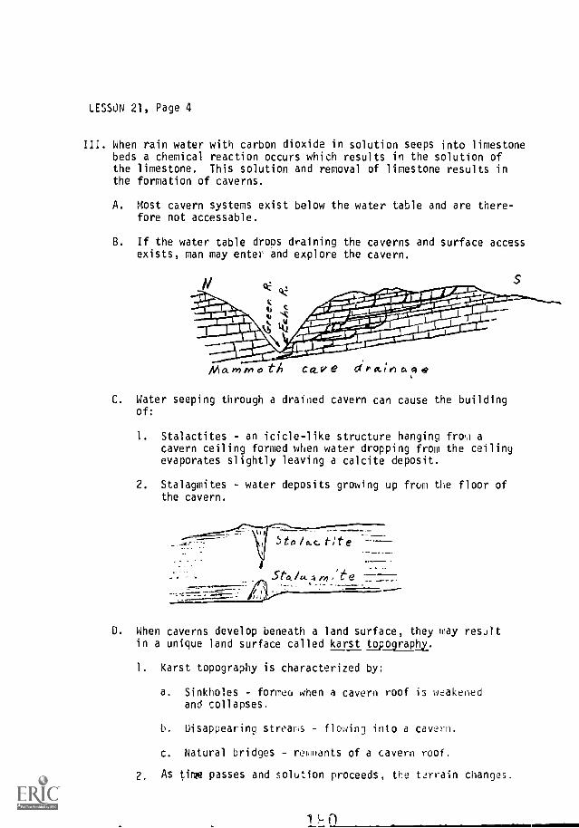
LESSON 21, Page 4
III. When rain water with carbon dioxide in solution seeps into limestonebeds a chemical reaction occurs which results in the solution ofthe limestone. This solution and removal of limestone results inthe formation of caverns.
A. Most cavern systems exist below the water table and are there-fore not accessable.
B. If the water table drops draining the caverns and surface accessexists, man may enter and explore the cavern.
eC ciz:
:NA x -411i10111.1-r*,..414.dxr, ' .....,,,-""
tralbonamouw u t
Oarftkh 44 Agga;n5AlillligilleirIi_nia \, isorsodiiNal Z u'
1011WiOpm=ri " Nowilo°161"--
Mo- vr,rrro tA CaV e r4.1eiagA
C. Water seeping through a drained cavern can cause the buildingof:
1. Stalactites - an icicle-like structure hanging from acavern ceiling formed when water dropping from the ceilingevaporates slightly leaving a calcite deposit.
2. Stalagmites - water deposits growing up from the floor ofthe cavern.
5to etc eI-Sta. /u. 4 e
D. When caverns develop beneath a land surface, they may resultin a unique land surface called karst topography.
1. Karst topography is characterized by:
a. Sinkholes - forme(' when a cavern roof is weakenedand collapses.
b. Disappearing streams flowing into a cavern.
c. Natural bridges - rehflants of a cavern roof.
2. As time passes and solution proceeds, the terrain changes.

LESSON 21, Pace 5
Late foutA
Al a turity
3. Small cavities in lims..tone may, under certain conditions,be filled by crystals growing out from the walls into thecavity. Such round groups of crystals are known asgeodes and are valued as collectors items.
E. In North Carolina massive limestone formations occur across thecoastal plain; however, the only known caverns occur at Linvillein a portion of the shady dolomite formation.
181

LESSON 21, Page 6
IV. While most of the material taken into solution by ground watermakes its way eventually to the sea; some is left behind whenwater evaporates from the soil.
A. When excesses of salts and calcium carbonate are concentratedat the surface, a crust or caliche may form. This type ofhardpan surface can be found in many deserts.
B. Often the movement of ground water will transport and concen-trate material in layers below ground or in lumpy forms calledconcretions.
182

LESSON 22, Introduction
EROSION BY ICE AND WIND
Objectives:
1. To develop a concept of the effects of ice and wind as erosionalagents.
2. To understand the processes employed by ice and wind in erosion,transportation, and deposition of material.
3. To gain a knowledge of glacial and wind-caused land forms.
References:
1. FOCUS ON EARTH SCIENCE, Chapters 15 and 16.2. INVESTIGATING THE EARTH, Chapter 12.
Special References:Wolfe, et al. EARTH AND SPACE SCIENCE (D. C. Heath & Company, Atlanta),
ChapteH' 16 and 18.Strahler, PHYSICAL GEOGRAPHY (John Wiley & Sc s, New York), Chapters 28
and 26.Gilluly, et al. PRINCIPLES OF GEOLOGY (Freeman Publishing Company),
ChaptersT3 and 15.Holmes, PRINCIPLES OF PHYSICAL GEOLOGY (Ronald Press, New York),
Chapters 20 and 22.
Activities:
1. Wind is a destructional force helping to create the landscape.
Materials:
electric fansandlarge box
Procedure:
On a windy day observe what the wind does to leaves, twigs, andother debris on the ground. Look in corners protected from thewind and notice that soil, 'eaves, and other materials are some-times deposited there.
Pour a pile of dry sand or granulated soap on the bottom of alarge carton cut away on one side. Turn an electric fan on thepile of sand and notice how the particles are moved. Noticethat more particles are moved as the velocity of the windincreases.
Put an obstacle such as a pencil or finger in the path of theblowing sand and observe what happens. Relate this to theprinciple of snow fences and the behavior of sand dunes_
18d

CHAPTER 22, Introduction, Page 2
2. Ice can be plastic, depending upon the speed with which pressureis applied.
Materials:
aluminum foila freezerwater
Procedure:
Freeze an elongated bar of ice approximately 19 x 2 x 1 inches.(Aluminum foil may be used to make a tray of the proper size.Remove the ice from the tray and, while keeping it at freezingtemperature in the freezer, suspend it at both ends. Place aweight in the middle of the bar. After a few hours, the bar ofice will be bent and will not spring back to its original shapeafter the weight is removed.
3. The melting point of ice is lower when under pressure.
Materials:
freezerwireweight
Procedure:
Suspend a bar of ice at both ends in a refrigerator or deepfreezer where the temperature is at or slightly below freezing.Loop a wire around the bar, and suspend a weight from the wire.The wire will be seen to eat its way down through the block.The water produced by melting under the pressure of the wirewill refreeze in the crack above the wire where the pressureis less.
4. Ice flows plastically near the bottom of a glacier. Thl upperpart of a glacier is brittle.
Materials:
ice
hammersilly putty
Procedure:
Demostrate the brittleness of ice when not under pressure bybreaking ice cubes with a hammer. Demons'rate the plastic flowof ice by placing some silly putty on a sluping surface andobserve it flow under its own weight.
1R.;

LESSON 22
EROSION BY ICE AND WIND
I. Introduction
In areas of colder climate, ice may accumulate to such a depth thatit begins to behave as a plastic and flow. Such a unit of flowingice is called a glacier.
A. Valley glaciers (alpine glaciers) occupy valleys previouslymade by streams.
B. Piedmont glaciers are glaciers located on a plain at the baseof a mountain range and fed by one or more valley glaciers.
C. Continental ice sheets are broad glaciers of irregular shapegenerally blirTeTTFITThe terrain.
D. Glaciers (all types) cover about 6 million square miles ofthe earth's surface. (about 10-11% of the earth).
II. Glaciers advance away from a source area or zone of accumulation.
A. The two chief requirements for glacial formation are:
1. Low temperature
2. Adequate snowfall (more falls than melts)
B. Glaciers are found in high latitudes and high altitudes andare more numerous along wet coastal areas.
C. Zones of accumulation are normally found above the snow line.The snow line is the elevation above 41110 the air temperatureseldom rises above freezing and snow tends to accumulate ratherthan melt.
III. Snow accumulates as the source of nourishment for a glacier.
Most glaciers can be divided into two zones.
A. Zone of accumulation.
1. Snow accumulates, but air spaces in crystals allowevaporation, forming water vapor.
2. Snow becomes granular (as does all old snow).
3. Compression due to the weight of overlying snow causesice to form.
1 C.)A u it

LES!ON 22, Page 2
B. Zone of net wastage.
1. Area in which melti.A2 is grer:,er than eccomulation.
2. Meltwater results from the melting of glacial ice.
3. Glacial deposition occurs in this area.
Zemeetc Ct4h144 lot c,
Zone or netwas ta,, e
Me /t/e,9
IV. Ice is a weak solid. Its own weight is enough to overcomerigidity so that it becomes deformed, flowing downward andoutward as a stiff liquid. (Example: putty or clay)
A. Observing change of pos.ition on a glacier was the earliestmethod of detecting movement.
B. Surveying a line of stakes across the glacier can detectthe movement of a glacier.
1. Sides and bottom of the glacier are thought to be heldback by friction.
2. The cente- of the glacier is for to move fastest.
3. Crevasses form in the brittle upper su :-face of theglacier as it. moves.
0r4.ea r
tar er
186

LESSON 22, Page 3
V. A glacier transports material known as its load.
A. The load of a glacier may be carried on top, in its sides,and within the body of the glacier.
B. Much larger particles can be carried by a glacier than bystreams or wind.
C, The load is concentrated in the base and sides of the glacier.
VI. A glacier carries on erosion by abrasion and plucking and isgenerally accompanied by weathering in the form of frost wedging.
A. Frost wedging cra0s, splits, and prepares rocks fcr glacialtransportation.
B. Glacial plucHog is the lifting out and removal of pieces ofbedrock by a 914,:ier.
I Piece!' are quarried wt, especially on tfie downstreamside of the glacier.
2. Water aids plucking by freezing and lifting
C. Abrasion is a filing process.
1. Ice makes scratche', and grooves called Ilacial striations-
2 These striations and the asymmetrical shape of rock hillspoint the direction of the movement.
a) Upstream side - abraiced, striated, geltly slopingb) Downstream side - preiominantly plucked, steeper slope
S 14 it e
VII- The eroding action of glaciers, particularly valley glaciers,creates unique features which identify previously glaciatedmoultain ranges.
A Cirques - steep-walled, bowl-shaped depressions at tale headof glacial valleys. Formed by plucking at the head of theglacier.
181

LESSON 2?, Pie 4
h?Ded - rau5ed by er7s'on of br,th the sides and baseglacieYs.
- The head et the ,.a.ley is usu,61'y marked by a cirque oftenwith a c,,1W take lecated 'H the depression called a tarn.
7."--,j
0-----'--. p" .,, /I e ,/
, - ..., ,. 1
---N.......----" / .d ...."..s, "60 1( / i I
,.4..........<5,...,,, )-.........., 7....:1"7, -.. /
-------_,/2 Dep-Psslo,s gouged in the df.-"ey "oer may contain small
enged (f'ngerl 'akes o chains of small round lakes(oiernoste, 'ak90
3. When the o'd alleys a'e flooded, they a-e knownis f.'o'd3
NO'E Cc,ninenta' giar'e's yeriery do not cut U-shaped3"E"0E qii-Te deep d rover both
vale,(.
C- Arete a jig.vs0, kn,fe-edcie dge ':,eated by two cirquesT;TW-ha n") thr. dc. r'crn both s'de.
...,11*;,.. ,C' /,--;-7.:do:', ..,.'1-40...., 1 /
.........._:-..--- 7
-`:=::,.--
,, \,-, / ..,- 1 I :
'S, , 1 % ' ',
1 . I i : ,......;I i I. '''''''\ '''' \_. - .---' ..< \V. \ ' ), 'o., :-o`o,.......,',.........-
--,'...ri,s-\ '."-----".:,:**'\:".
l-.....->\.,.........,.,
o
t',' C--- .,' 0 1,
1
// .... o,../ --,-- o k
1....,?,/ ; ' 2...-
_-- .'oo.
f",-.,--- .-
C Co) , a kn 4e.edgrJ, caddie r,dge fcrJ-Rd whe^ the same typee-o(-00.: th3* (nPd an a-7'f,, cortinued erod4ng both
s'dec o: a
E i cle-,k left sanding W:eret:17; o' fr.) e l'ife'Fni directions.
186

LESSON 22, Page 5
,--
o:5
.t ",,\ r :,-- ':;" \ k .5,, 5: 4',..:1 e...<:\x.--,..- -. \ ,---
___........,::::::, -\ -,y,,..---.--....,.-' i
/ ."-r".----',' ; )-''''''. :,..7,....
i -
......,.:a ..-A
8/
/ '''
/\,\ '' /i /)
... \.7., ,......,
VIII. Glacial dep)sitlor takes.. E.)a::e tfirn IV 'r the driostrea'r, oortion
of a glacier where meting -e'eas:=: felt; from the ice.
A. Till - (non-stad Yate.'al so..ter a':.:c-d;rig to size
and weight but lying ,,.It as it ,Pleased 'From the ice
The term (It.111P ,'sorted r.lepos'As.
B. Moraines are land c-Jrrent'F'te,4 by a f,om a till.There are s.Jera tyo:
1 . Ground woraine - roar, ,d tNfr t" ',Jth genera'lysmor)t. su,face ;or: 'Rsoltng frOM iregUlardistribution o* 7-r1,;; gA,;:efi 'I !He Lorin asthe clacier
2. Tercr;9a: mo.rere - 5u'it at theend of a the stat'oarylosing t'ie "E,-
3. Recesienil mor,3!re - -et-?at forminga sere of !_!ges
4. Lateral : fJ! 7,0 o' l*e
5 TPr. ro - 3 W val eygL;cier$' 1rd c-1.! 1,4 ] {'/..P' c c glac.;er,
5", `;;;;;":;--.....:'
r /-
5"'
f'
: .77!;. .
I e .- ,
`.- , ,
18)

LESSON 22, Page 6
6. Drumlins - Streamlined hills molded by flowing ice;offers minimal frictional resistance to the ice flowingover them. (Indicates direction of flow of formerglaciatioo.)
7. Erratics -Glacially deposited pieces of rock that aredifferent from the bedrock beneath them,
IX. Meltwaters from glaciers also erode, transport, and deposit materials.These materials tend to be sorted and stratified, but their originsare usually clearly glacial. The materials can be separated into twocategories.
A. Outwash deposits.
1. Outwash plains are formed by water flowing away frommelting glaciers. They typically are broad, flat, andfound in a portion of the valley or region formerlyoccupied by the glacier or just beyond the terminal moraine.
2. Valley trains are stratified deposits partially filling avalley.
B. Ice-contact stratified drift landforms are developed by runningwater in contact with ice.
1. Karnes - low, conical, steep-sided hills formed by waterpouring over the edge of a glacier. The internal structureis normally stratified with sore slumping which occurredwhen the ice melted.
2. Eskers usually narrow, steep-sided serpentine ridges ofgravel and sand with an internal slumped stratifiedstructure. They are believed to represent channels ofstreams which flowed on top of or within the melting glacier.
3. Kettles - depressions in the ground moraine caused by themelting of buried chunks of glacial ice.
190

LESSON 22, Page 7
X. Wind is the least effective of all the erosional wit.; .o:!,nier,it still does considerable work in terms of shaping lane;.
A. Wind is more effective in areas that are arid
B. Wind is particularly effective in rjserts arc, a s)res.
C. Wind is also effective in fiat areas and in ar-a,, of glacialdeposition.
D. Many plains and plateaus fit into the catenori 1 aJov:?
and are especially affected by And -?rosion.
XI Wind erodes the land surface in at 12ast two
A. Deflation - picking up and removing loo., articl:s ,y t.
wind.
1. This process removes the smaller particls anc', 12av,,s
the larger ones as a surface covering call.Apavement."
2. The wind also excavates hollows or 62pressions 6,41atic.1.
B. Abrasion (grinding; by particles carried oy inu 7roduc?sventifacts which are polished and faceted franms of roc,:.
rP,/,ch.
XII. Winds build deposits on deserts, plains, and 3eac!.es.
A. Dunes are constructed w:len wind slows down, droppino maLr:al.The size of the particles and the amount of material t
can carry depends on the wind velocity.
1. [runes are hills of wind-blown sand.
a. Started by an obstruction.
b. The more gentle slope on t!le windward sid? ca!_!'G
by the flattening action of the wind.
c. Barchanes are crescent-shaped dunes fordblows around edges of the dune
1)i

LESSON 22, Page 8
2. Dunes migrate downwind as particles are blown across thedune.
00
llll
476.4 ',Lt./tides', --------1(7'r/1"dianb evt oeune
B. Loess is a deposit of silt-sized partic'es.
1. There are thick deposits in Kansas,
2. Loess is composed of very fertile soil, but is weak andsusceptible to erosion.
192

LESSON 23, Introduction
DEPOSITION AND SEDIMENTARY ROCK
Objectives:
1. To develop a concept of the processes involved in the formation ofsedimentary rock.
2. To understand that environmental conditions may determine the type ofrock formed and, in turn, indicate part of the history of an area.
References:
1. THE EARTH-SPACE SCIENCES, Chapters 23 and 25.2. FOCUS ON EARTH SCIENCE, Chapter 6.3. INVESTIGATING THE EARTH, Chapters 2, 18 and 19.
Special References:Wolfe, et al. EARTH AND SPACE SCIENCE (D. C. Heath & Company, Atlanta),
Chapter 9.Gilluly, et al, PRINCIPLES OF GEOLOGY (Freeman Publishing Company),
Chapter TT.Holmes. PRINCIPLES OF PHYSICAL GEOLOGY (Ronald Press, New York), Chapters 6
and 7-
Activities!
1. The making of a fossil.
Materials: shells, boY,-.,s, plaster of Paris, containers, modeling
clay
Procedure:
Place a layer of clay in the bottom of a small container. Press thebones or shells into the clay. Lift the bones or shells out care-fully so that a clear imprint remains. Mix plaster of Paris andfill the cavity in the clay. After the plaster has set, remove thecast from the mold.
How does 'Ale clay compare with settling sediment? How does theplaster of Paris compare with minerals deposited in ground water?
2. Investigating an ancient stream channel,ESCP 18-4 Text 396
Teacher's Manual 492 and 495
3. Investigating the puzzle.
ESCP 18-6 Text 399
Teacher's Manual 495 and 497
193

LESSON 23, Introduction, Page 2
4. Investigating areas of erosion and deposition.ESCP 21-2 Text 457
Teacher's Manual 581-582
5. Investigating the leveling process.ESCP 21-3 Text 488
Teacher's Manual 582-584
.119

LESSON 23
DEPOSITION AND SEDIMENTARY ROY
I. Introduction
The material eroded, transpored. and oepnsited by 2-t.v, water,wind, and ice is transformed 'nto sedir,.entry FAk by -the orncesses ofcompaction and cementation 'iedimentan, d,iided into twogroups which are based in part on their orir.
A. Fragmental. sedimentariei ,;re made up c) f!';:dments of other rocks
that have been cared by oJite.-, w,n1, or 'C2 and dmosited,compressed and cemented to co7m ro0.
I. These types of rocks are gene'l/ly 11'?uped a':cording to thesize of fragments they ,:rita;n
a. Conglomerates are r.0arse-grainen and formed from fragmentsvarying in sle F.-0m boJlders to 5:m01 par titles. Theparticles ,13J come 1"-r.,1f. cfle o!. sever'l tyoes of rock
(Boulders we,-- 265 mm o 10 ,nches)(Cobbles 61-264 mm or 2.5-i0 i idle_
(Gravel 2-64 mm or 0 8.2 5 inc:les)
b. Sandstones a-e tc.--med cemervA 0cains
(Sand ,2-2 ira o 008-,08 inches)
c. Siltstones_ are
(Stlt .02 2 tx,.. pr 0068-008 inches)
d, Shales are furred ma-mly by r_ompactl,'.,n from 6a;'
particles and tend r.o .tritD plates-
(Clay less than 02 nor 0.- 0008 incnef-,)
B. Chemical sedientar,es e mater'als prec;pitatedfrom solution in water
1. Fragmental 1,m,..stonei. 1--,v,e:-,tec.; Ann: or c--ecioitated.
The particles trY7' !]rye tc m,c-oco)ic shells,and they usually are ce7w0ted o/ oeeclpitatr-d 1-mestr.ne.
2. Limestone (CaC01) lay be pre,j0t.,ited chen'cal solutions
because of evaowaI7or or 3 In temper
3 Dolomite 'do-1(1,7,1:4c :1flieEtir Cfl)(CO,r,)
wren calc.um vlagre,.
.Y. 1.9 ti-A

LESSON 23, Page 2
II. Compaction and Cementation.
A. Before loose sediments can be cemented effectively, they usuallymust be compacted to some degree. This is usually accomplishedby the weight of overlying sediments being deposited on an existinglayer. The increasing weight forces water and air out and movesthe particles closer together.
B. Deposits sometimes do not form sedimentary rocks because they areonly deposited for a short time, to be picked up agE:n andcarried on to a new site by running water.
C. Compacted sediments are slowly cemented into rock by small amountsof substance usually dissolved from the sediments themselves.
1. The principal cementing materials include:
a. Silicon dioxide (quartz).
b. Calcium carbonate (limestone).
c. Ferric oxide (rust).
2, The resistance of the various cementing agents to weatheringvaries considerably. Thus the character of the weathering isin part, dependent on the cementing material in a particularrock.
Limestone is by far the most common sedimentary rock. Therefore, thecharacter and formation of limestone is of some interest.
A. Tha same water that carries solid fragments may also carry dissolvedcarbonates.
1. Calcium carbonate is the most important of the carbonates.
2. Calcium carbonate is insoluble in pure water.
3. Calcium carbonate dissolves easily in water containing CO2.
4. The solubility of CaCO3 is also affected by temperature andother conditions.
5. Thus, precipitation may occur in certain areas were conditionsare right.
B. The most common source of CaCO3
is the skeletons of plants and aniralsthat live in the sea.
1. Generation after generation vast 'numbers of skeletons settle tothe bottom of the sea.
1

LESSON 23, Page 3
2, The skeletons are corioar*ed into dep:sits* 0. TEItcn9
3 Coral is a'so resoons!ble fo large deposits of limestone.
C. Varieties of limestrsre.
1- Most limeslAne 's dense or very fire Grained and eithe,light, or claFk- grey in color.
2. Chalk is a variety of 'imestone como3sed of arc-osccpic she;ls,
3, Soell limestone - Shell fragments cemented t:oetni?r ^r l'Wng
4. Coquina - Composed of recent shells or shell fragments )ooselycemented
5. Travertre Ci'e deposits.
6. Flint nodules a -e also found in limestore:z The amP sil-iceous concrel-ions w'tnin the lrestone
IV. Character and information f'om sedimentary rocks.
A, The classifYation of sedimentary rc,cks is !.),=:ed on tpx'.ure,
riineral composition, and nrigin.
Texture pw.ides listinction between congomeratP, slndne,and shale and s'tstone
2 Chernical r,omp3sit;:n (minerals) o,o'ides d7stinct:ion betw9enlimestone and c,*-he_- sedimenta,y 'L'mest,s1rpeffei,esne in 1-1f.:111
3. Ortg'n 's Pso heloft.;, 'n c.entF-y
B. The chara:te7 and stfur,-)te of a cedimentary pay y'e:information the 'n tin a.2a v)cip' " wasformed
re. -fain types co. sYk are undeExample:
a c2,a1 (eef:, in t--o-a*- and so7' -rlyre'
b. Sandstone is usually deposited 'r a tear17itlCni Ent,'"?1IMPnt.
C. Cong'oTerats i'e formed by waer '0.'n5 r3p-try tihpn filAt
wafer is slowed down

LESSON 23, Page 4
2. The thickness of sedimentary layers (beds) tells somethingabout the time required for their deposition.
3. The fossils present give information concerning environment,age, conditions in the area, etc.
a. Fossils are found only in sedimentary or very slightlymetamorphosed rock.
1) Fossils are the remains of ancient life,2) The chances of preserving an organism as a fossil are
exceedingly remote.
a) The organism must be buried at the time of deathor within a few days after death.
b) Normally only the hard parts of an organism arepreserved.
b. Fossils are often helpful in determining both geologicage and changes of environment.
1) Index fossils - Often found in rock layers of onegeologic time only. The position of a formation maybe established with respect to time.
2) Environmental fossils - Indlcate the environmentalconditions of a certain age. (Example: marine vs.fresh water)
C. There are three major types of fossilization.
1. Essentially unaltered remains:
a. Entire remains preserved (exceedingly rare).
1) Frozen mammoths and other mammals.2) Amber sometimes preserves insects intact.
D. Hard parts only preserved (usually recent),
1) Bones of mammals have been found.2) Some dinosaur bones. (Dinosaur National Monument)
2. Altered remains.
a. Carbonized - Plant remains changed during coal formation.
b. Replacement due to ground water. Origiral cells replacedby minerals out of solution it ground water.
1) Calcified (CaCO3)Process often referred to
2) Silicified (Silica). as permineralization.3) Pyritized (Pyrite). (petrification).

LESSON 23, Page 5
3. Indirect evidence of presence of life is octen Preserved,
a. Casts and molds
b. Trails, tricks, and burrows.
c. Fossil excrement.
d. Artifacts are important in the study of early man.
e. The study cr= fossil evidence is a suYoranch of the scienceof Geology known as Paleontology.
D. The order in which rocks are formed and their arrangement fall intothe realm of structural geology and stratigraphy. Tlis informationtells much about the order and sequence of events.
183

LESSON 24, Introduction
DIASTROPHISM
Objectives:
1. To understand the process of diastrophism.2. To develop concepts of isostasy and plastic deformation.3. To create an image of the landforms developed by diastrophic movement- -
particularly folding and faulting.
References:
1. THE EARTH-SPACE SCIENCES, Chapters 23 and 25.2. FOCUS ON EARTH SCIENCE, Chapters 17 and 18.3. INVESTIGATING THE EARTH, Chapters 14, 16, and 18.
Special References:Wolfe, et al. EARTH AND SPACE SCIENCE (D. C. Heath & Company, Atlanta),
Chapters 11 and 12.Wyckoff, ROCK, TIME, AND LANDFORMS (Hager & Row Publishers, Inc.,
New York), Chapter 5.Gilluly, et al. PRINCIPLES OF GEOLOGY (Freeman Publishing Company),
Chapters 6, 8, 9, 10, 19 and 20.Holmes, PRINCIPLES OF PHYSICAL GEOLOGY (Ronald Press, New York), Chapters
2. 3, 9, 26 and 27.Shelton, John S., GEOLOGY ILLUSTRATED (W. H. Freeman and Company, San
Francisco).Strahler, PHYSICAL GEOGRAPHY (John Wiley & Sons, New York), Chapters 29
and 30.
Activities:
1. Development of an idea-James hall's Field Trip.ESCP 14-1 Tert 312
Teacher's Manual 379-333
2. Developing a folded surface.
Materials:
Different colors Of clay and a cutting wire.
Procedure:
Roll (flatten) several layers of clay and put them together. Fold thelayers by pressing from the edges. losing the wire tut the sandwich aswater would erode the surface. Repeat the process eroding horizontalstructures as well as plunging anticlines and syncline..
3. investigating regional landscapes.ESCP 21-7 Text 467
Teacher's Manual 590-595
200
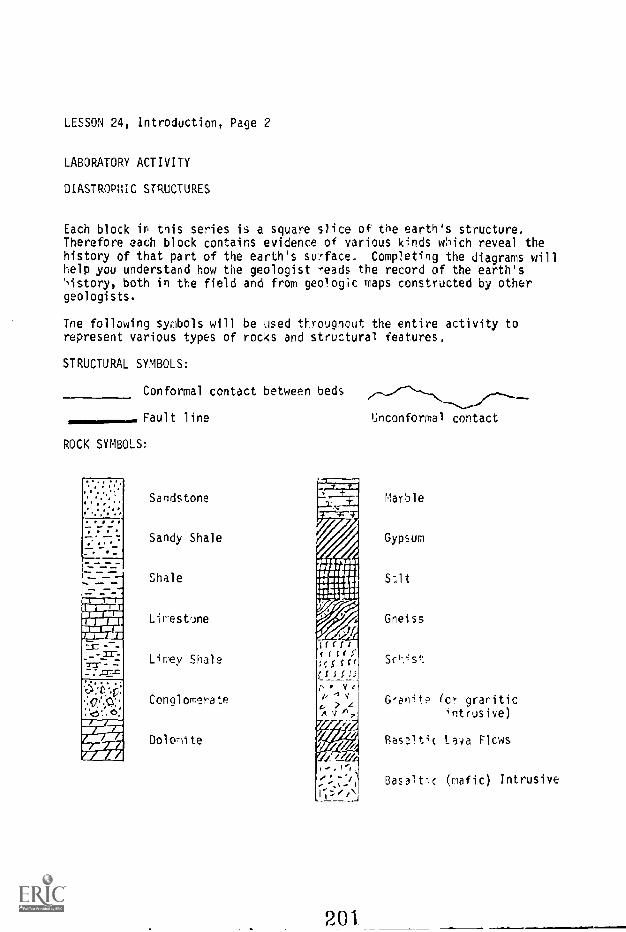
LESSON 24, Introduction, Page 2
LABORATORY ACTIVITY
DIASTROPHIC STRUCTURES
Each block in this series is a square slice of the earth's structure.Therefore each block contains evidence of various kInds which reveal thehistory of that part of the earth's surface. Completing the diagrams willhelp you understand how the geologist reads the record of the earth's',istory, both in the field and from geo!ogic maps constructed by othergeologists.
The following symbols will be used throughout the entire activity torepresent various types of rocks and structural features.
STRUCTURAL SYMBOLS:
Conformal contact between beds
Fault line Unconforrnal contact
ROCK SYMBOLS:
Sandstone
Sandy Shale
Shale
Limestrine
Limey Shale
Conglomerate
Dolomite
Marble
Gypsum
Irf /IUP Sit
Gneiss/,
liffcssrf;5f f CrLI S I !
V
4
201
G-anite (or granitic,ntrusive)
Basalt4c ta4a Flows
Basalt:c (mafic) Intrusive

LESSON 24, Introduction, Page 3
STRIKE AND DIP SYMBOLS:
To indicate strike and dip a small symbol (, ) is made on a geologic map.The long line shows the direction of strike and is made on the geologic mapin the compass direction of the striki7The short line shows the dipdirection and is always at right angles to the strike. A number indicatesthe angle of dip.
EXAMPLES: (North is to the top of the page.)
141
Strike: N - SDip: 45°E (1) Horizontal Beds
Strike: N25°WDip: 15°NE
1 Vertical Beds Strike: N15°EDip: 90°
AV Overturned Beds Strike: N90°WDip: 15°N
BLOCK 1
1. Complete the block by putting in all the necessary symbols.
2. What is the strike and dip of the beds at the surface? Put the symbolon the map.
3. Assuming that the icneous body is the oldest rock in the block,
a. What is the name'applied to the contact between the conglomerateand the igneous body?
b. Wilte the sequence of events which would account for the structureof the block. (Remember to write the oldest on the bottom.)
5
4.
3.
2.
20"41.

LESSON 24, Introduction, Page 4
4, Assuming that the igneous bcdy is the youngest rock it the block, writethe sequence of events which would account for the structure of the block.
4.
3.
2.
1.
5. If the vertical scale of the block is 1 inch = 1,000 feet and the rateof deposition is 1 inch every 1,000 years, then the depth of thesediments in the southeast corner of the block represents
years of deposition.
203

LESSON 24, Introduction, Page 5
NOCK 1
__--/-
A
N
.. _ ._, ....... _--........ ..., .... . --.__ . ----- -- -- -- --soo,1, ,, / 0 .0 1 g 4: . II. Pp, O. Pp
°.f., <15 : : CI . 6 : : .. CO 'W. p ....._..-,, , o .. tz, . 0 ...6
A >v>, ,Yv V Jy,.1
. 0 . t) .. c:. . d : :v..'D: C. :........c!..!.,C3'... ...:?..._$-_2.,.//;
.>i, V A t'
20

LESSON 24, Introduction, Page 6
BLOCK 2
1. Complete the block by putting in all of the necessary symbols.
2. What is the strike and dip of the youngest bed?
3. Assuming the younger beds to be eroded away, what would be thestrike and dip of the older series of beds?
Strike Dip
4. What is the name of the contact between the horizontal series of bedsand the dipping series of beds?
5. What is the difference between the contact in question 4 and thflcontact between the conglomerate and sandstone in the dipping seriesof beds?
6. Write a complete sequence of geologic events for this block.
13.
12.
11.
10.
9.
8.
7.
6.
5.
4.
3.
2.
20,E

LESSON 24, Introduction, Page 7
BLOCK 2
V* \ \ NNII
.-
. ... \
. ....
...
..0. 0..o. .-, ., , . ........ ...Is,,., ,,.0\\ ., ..
. ,.- , ..
200

LESSON 24, Introduction, Page 8
BLOCK 3 and BLOCK 4
1. Fill in the necessary symbols and assemble the blocks.
2. What is the structural form of block 3?
J. What is the structural form of block 4?
4. What three MAJOR events resulted in the present form of the blocks?(List oldest first)
3.
2.
1.
5. Show the strikes and dips for points A, B, C, D on each block
Block 3 Block 4Strike Dip Strike Dip
A. A.
B. B.
C. C.
D. D.
6. Plot the stril,a and dip for each of the points on the map.
7. Compare blocks 3 and 4. How can you tell the difference between ananticline based on strike and dip symbols?
8. How do the ages of the rocks compare as you approach the fold axis ofthe anticline and the syncline?
9. Are the oldest rocks found to the inside or the outside of the fold?
10. Why are tAe beds parallel on the geologic map on the surface of the block?
on


LESSON 24, Introduction, Page 10
BLOCK 4
1
111....
_
C
.... ... e-/-,,,, /".,.... Off,
r...",
'Y' 0:,, .:, ....
t, de , . . .
',,,,y/ ... ...,",... : 1 : :
.
..
mmi.m=mowl.,..1
5/.

LESSON 24, Introduction, Page 11
BLOCK 5
1. Fill in all the necessary rock structure.2. Draw the geologic map on the top of the block, Put in the appropriate
strike and dip symbols.

LESSON 24, Introduction, Page 12
BLOCK 6 and BLOCK 1
1. Fill in all the necessary rock structure and assemble the block.
2. Orz..w the geologic map on the top of the block. Include strike and dipsymbols and symtols showing rock type.
3. What geologic structure is shown in Block 6?
What geologic structure is shown in Block 7?
5. The structure in block 6 is plunging in what direction?
6. The structure in block 7 is plunging in t.l'at directicr.?
7. What is the angle of plunge fur each block?
Block 6 Block 1
211

LESSON 24, Introduction, Page 13
BLOCK 6
212 ...--a.-.a1

LESSON 24, Introduction, Page 14
BLOCK 7
Use any rock type symbols you wish. Make sure, hweyer, that they matchthe 12propriate parts of the bloLk.

LESSON 24, Introduction, Page 15
BLOCK 8 and BLOCK 9
1. Fill in all the necessary rock structure.
2. What type of fault is block 8?
3. What type of fault is block 9?
4. For each of the blocks, has the su..face been lengthened or shortened?
a. Block 8 b, Bleck 9
5. How much has the surface been shortened or lengthened in each block?(Horizontal scale: 1 inch = 1,000 feet)
a. Block 8 b, Block 9
6. How much movement has occurred along the fault plane? (Vertical scalesame as horizontal)
a. Block 8 b. Bluck 9
7. What is the vertical displacement of each of the blocks?
a. Block 8 b. Block 9
8. Match the following labeled points on the diagram to the terms below.
BLOCK 8 BLOCK 9 TERMS
A A 1. Fault line2. Dowlthrown block
B B 3. Uoth'own block_4. Footwall
C C 5. Beddirg plane
D D
FF
9. What is the strike and dip of each fault?
a. Block 8 b. Block 9
Strike Strike
Dip Dip

LESSON 24, Introduction, Page 36
BLOCK 8
C'z -1;3.
II
.
1. .1.1*1
.1*
-.1:141
NIIi
it::
IIIsil
54-- 0
1 II I
,t ti, i, I I
I I 1
1,II
I 11 I
C
n 1 '7

LESSON 24, Introduction, Page 17
BLOCK 9
I I1
I ill 1
1 1 11, 11,'I I. I
I 1 III,1 i il
E D
k.--- A ' 1 11fl iii
11101I I III
111 I1'H ilk
.1.4141
210

LESSON 24, Introduction, Page 18
BLOCK 10
1. Complete the block by putting in all the necessary symbol'-.
2. Complete the geologic nap on the top of the block. Include aly necessarystrike and dip symbols for both the faults and the sedimentary strata.
3. What two types of faults are shown in this block?
A
4. What is the displacement alo4 fault A? (Scale: 1 inch = 1000 feet)
5. At the same scale, what is the displacement along fault B?
6. Write a complete sequence of geologic events for this block. Includeeach sedirrentary layer. (Remember, oldest on bottom.)
11.
10.
9.
8.
7.
6.
5.
4.
3.
2.
1.

LESSON 24, Introdurtion, Page 19
BLOCK 10
1

LESSON 24
DIASTROPH:SM
I. Landforms.
A. The processes of diastrophism and volcanism are responsible for themajor landform features in the United States. Examples: mountains,plains, plateaus, etc.
B. The geomorohologist classifies landf:Ilms according to:
1. Their structure.
2. Their topography.
C. General types of landform:.
1. Plain - a region of low "elief and horizontal rock structure(maximum relief -.. one or two hundred feet),
2. Plateau - a region of horizontal rock structure with highrelief (more than 1,000 feet),
3. Mountains - landform; with a relief greate than 2,000 feet,and a rugged summit of relatively small area.NOTE: All true mountains are composed of rock masses in anonhorizontel Or disturbed position, they may be tilted,folded, domed, Or built up of volcanic material.
II. Life History of Landforms,
A. Constructional processes Fire constantly opposed by destructional(erosional) p-ocessci.
B. Constructional landfc-ms :re emlst never seen in their initialstate.
C. Ideally !andforms pass throush Orec stages of dewelcpment.
1. Youth,
2. Maturity
3. Old age.
Taken together, they make up the life history of the landform.
D. Landforms do not always c..:...1plete the cycle. A mature plain may beuplifted long before it has ...cached old age; entering i!)stead intoa youthful stage again.
210

LESSON 24, Page 2
E. Definitions of life stages:
1. Youth - lands,:ape has rugged topography with steep slopes anddeep narrow valleys.
2. Maturity - ;Iilace is much cut up and shows a great variety offeatures.
3. Old age - landscape is worn down and most features are destroyed,
a. The flat surface resulting i. called a peneplain (almost aplain).
b. When uplift rejuvenates a peneplain, the topography isdetermined by the nature of the rocks that originallyformed the surface.NOTE: Piedmont Nortn Carolina is a dissected peneplain.The area was eroded almost to sea, level and then uplifted,allowing the streams to cut down into the plain surface,
c. Unconformities - result when tilted sedimentary beds arecovered by horizontal beds which cut across them. Thisindicates tilting, followed by erosion, followed bydeposition.
d. Disconformities - occur when erosion interrupts adepositional sequence and deposition resumes with nochange in the attitude of beds, either above or belowthe disconformity.
F. Structural relationships are good clues to the history of a region.
III. Before the Eighteenth Century, men attributed past 'rid present landformsto sudden catast^ophies.
A. In 1765, James Hutton introduced his theory of uniformitarianismto the Royal Society of Edinburgh.
B. Hutton's theory stated that "the present is we key to the past,"
1. The forces acting today are the same forces that have beenacting throughout the ages.
2. A slow, gradual process of building up by earth movement andwearing down by erosion is resoonsible for most of the landformspresent today.
IV. The Language of Landforms.
A. Physicgraphy is the branch of the earth sciences that deals with theearth's surface features. It incluees the earth's climates, theways man makes use of the soil, waterways, and many other resourcesof our planet. It enphasizes laddforms as to their effect on man.
1(7,1'1 _

LESSON 24, Page 3
B. Geomorphology is the branch of earth science that emphasizes land-forms as such. It considers their origins, the changes they undergo,and their past histories,
V. Diastrophic forces are the that cause the movement of parts of theearth's crust.
VI. Diastrophism and volcanism are very Oosey related, Diastrophism dealswith movements of the solid Portions of the crust while volcanism dealswith movements of magma.
A. There are three types of diastrophic movements:
1. Uplift - A local or widespread rising of the crust.
2. Subsidence - Sinking of the earth's crust,
3, Thrust - A horizontal motion of the crust, by which largemasses of 3c1c slide aga.nst one another into new positions.(Easily seen along San Andreas rift and at Chief Mountain,Montana,)
B, Ceuses of diastrophism.
1. Theory of isostasy. (Greek; means "equal standing")
a. Solid rock is somewhat plastic under certain conditions.tt flows and :hanges shape wen subjected to a greatpressure,
b, One may think of the crust as consisting of lighter,varitic continental material and heavier, basaltic oceanbasin material,
Intns.Ph' 6 4 (4-,,,vv
..,ler: t. A I
A v s Ip-p
773"7-171.1)......- ;--77------ 5" IeeeiA. .., V51.P 1 11 ? 4 , 4-
-, rt , r 'Alt), 4" V< Sp.6 r. =7=4 2 . 7
V > Ao
V y A a 'I- G cl
1/...1le c. r o r I .:7 I
M SP .6 r; ';--1 3.3Man$1 '" c'..
221

LESSON 24, Page 4
c. Under normal conditions, any region in which sedimentsare being deposited will subside under the weight of thenewly deposited material. Such subsiding basins are railedgeosynclines. Material deposited in geosynclinal basins may
reach enormous thicknesses.
d. When subsidence occurs due to increase in weight, an adjust-ment by subsurface rock "flow" results in uplift oremergence of other areas.
VII. Deformation of rocks.
Diastrophism results in forming metamorphic rocks. Diastrophic forcescause bends, breaks, and distortions in rocks.
A. Pronounced and continued pressure may cause rocks to be deformudinto wave-like folds,
1. The folds may range in size from inches to miles in length
2. The larger folds may be responsible for mountain ranges suchas the Appalachians.
3. The folding of rock under these conditions is called Masticdeformation.
B. Along with the folding there may also be breaking (fracturing)and movement along the breaks (faulting'
VIII. Folding - During uplift there is almast always some warping ofsedimentary beds. This results in shallow or steep domes and basinsdepending on the amount of deformation involved.(Example: San Rafael Swell, Colorado Plateau)
A. The crest of rock fold is called an anticline.
B. The trough of a rock fold is called a syncline.

LESSON 24, Page 5
C. If these structures could be seen ureroded, the' the anticlineswould be hills and ,he -zynclines valleys. (Example: Fingers ofthe Cascades into the , Tbia Plateau)
D. More often, however, only the eroded fo7ds can be seen.
E. Normally erosion more active at the top of anticlines,
F. As erosion continues, it may eventuclly form ridge and valleytopography, (Example: Shenandoah Mountains, Virginia)
AnticHnokir;dae
Table top /1
,AJley
ArCetini:f voile,
223 111111t1NM

LESSON 24, Page 6
G. Erosion may even convert the synclines into mountain:, if it isextensive enough.
H. Pitching folds: folds cannot continue indefinitely,
1. An imaginary line running along the top of an anticline orbottom of a syncline is called the fold axis,
2. If the axis is horizontal, or nearly so, the ridges formedwill be roughly parallel.
3. If the axis enters the ground at an angle (plunges), the resultwill be a cigar-shaped series of beds after erosion.
4. If the axis plunges in both directions, a basin or Jome mayresult.
IX. Fractures may develop fc a number of reasons -- cooling of a rock mass,release of pressure, folding, etc.: A )0int is a crack along which nomovement has taken place and where there is no space between the surfacesof the joint; A fissure is a crack that has expanded creating a spacebetween the surfaTirrrastic deformation and plastic flow eliminatejoints and fissures at depth, Joints and fissures due to other causesare also found in sedimentary rock and in metamorphic rock, but thosedue to Folding can usually be distinguished by their relationship tothe dip of the rock.
224

LESSON 24, Page 7
A. Faulting occurs if any slippage takes place along a joint or fissure.
1. Fault nomenclature (types of faults):
a. Vertical faults.
1) Normal (gravity) fault - hanging wall has moved downrelative to the footwall.
2) Reverse fault - hanging wall has moved up relativeto the footwall.
3) Horst and Graben.
22 5

LESSON 24, Page 8
b. Horizontal (thrust) faults.
B. Strike and Dip.
1. A geologic map or diagram shows the direction and tilt of arock bed in terms of strike and dip.
2. The device used to determine the strike and dip of a bed iscalled a Brunton Compass. (Contains clinometer for dip andcompass for strike.)
a. A clinometer is a pendulum mounted so as to show the amountof tilt of a bed, from the horizontal, when placed on thebed's surface. (Dip)
b. A compass measures the direction in which a bed runs alongthe surface. (strike)
3. Strike and Dip may be measured for faults, joints, and folds.
9911

LESSON ',!5, Introduction
DIAS1ROHISM-- EARTHQUAKES AND METAMORPHISM
Objectives:
1. To gain an understanding of the processes resulting in the generationof seismic waves.
2. To develop a concept of the behavior of seismic waves and the internalstructure of the earth that has been determined by their interpretation.
3. To relate metamorphism to diastrophism and develop a concept of theprocess of metamorphism.
4. To recognize the various types of metamorphic rocks and to unOorstandhow tney are related to and how they indicate the processes which theyhave undergone.
References:
1. THE EARTH-SPACE SCIENCES, Chapters 13, 14, and 22.2. FOCUS )N EARTH SCIENCE, Chapters 7 and 18.3. 1NVEST%ATING THE EARTH, Chapters 15 and 16.
Special References:Wolfe, et al. EARTH AND SPACE SCIENCE (D. C. Heath & Company, Atlanta),
Chapters 10 and 11.Stranler, PHYSICAL GEOGRAPHY (John Wiley & Sons, New York), Chapters 19
and 30.
holmEs. PR;NCIPLES OF PHYSICAL GEOLOGY (Ronald Press, New York), Chapters7 and 2E.
Gilluly, et al. PRINCIPLES OF GEOLOGY (W. H. Freeman & Company), Chapters18 and 19.
Pirrson and Knopf. ROCKS AN[' ROCK-MINERALS (John Wiley & Sons, Inc.,
New York), Chapters 12 and 13.
1. Inve;tigrting rocks from the cores of mountainsESCP 15-1 Text 332
Teacher's Manual 409-411
2. Investigating the :nside of a sphereESCP 16-1 Text 350
Teacher's Manual 443-444
3. Locating the epicenter of an earthquakeESCP 16-4 Text 354-355
Teacher's Manual 446-448
4. Investigating patterns of change-- Earthquake WatchESCP 1-7 Text 25, 26, 27
Teacher's Manual 49-51
22'7

LESSON 25, Introduction, Page 2
Have students make a scale model of a cross section of the interior ofthe earth. Using a scale of 12" = 8000 miles, they should be able todetermine the relative thickness of each of the sections of the inner earth.
RELATIVE THICKNESS OF LAYERS OF THE EARTH
Crust 25 miles = .04 inchesMantle 1800 miles = 2.7 inches
Outer Core 1300 miles = 1.9 inchesInner Core 900 miles . 1.4 inches (to center)
If the students are familiar with ratio and proportions, have them use thismethod to compute the above scale. (The thickness of the c-ust would haveto be represented by a thin pencil line,)
Example:
diameter of earth (scale) = thickness of section (scalediameter cf earth thickness of section of earth
or as computed for mantle:
12
8000 1800
000 N = 12 x 1800
8000 N = 21,600
8000 N 21 60080 8000
N = 2.7 inches
Cross multiplying
Dividing both sides by 8000
IA the basis of the same scale (12 inches = 8000 miles) have the studentscompute the relative height of Mt. Everest (about 5.5 miles) above sea level.This should give some indication of the smallness e the earth's surfacefeatures as compared with the diancter of the earth,
228

LESSON 25, Introduction,Page 3
CrJ
229

LESSON 25
DIASTROPHISM-- EARTHQUAKES AND ME7AMORPHISM
I. Movement of great rock masses within the crust is related to the forma-tion of metamorphic rocks.
A. Movement of these rock masses is the cause (not the result) ofearthquakes,
B. Most earthquakes are the result of movement along an existingfracture in the deep rock beds.
1, The walls of a fault are ',61JaIly very closely pressed together'
2. Beds under stress go through many years of increasing pressurebefore they move along a fracture
a. This stress often results in the metamorphasing of therock beds involved
b. When the stress becomes so great that it exceeds thestrength of the rocks, a sudden movment occurs relievingthe pressure
c. This movement causes seisy6c waves called an earthquake.
C. Elastic rebound theory,
1. Pressure exerted on t4C adjacent rock areas from oppositedirections (may be any direction) for a long per;od of timecauses the rocks to bend slawLy as strain increases
2. Finally the stra r becomes sc great that the rocks break andrebound.
11' 6./ g
111
Vol r r,,t, r +\ ..-."..,,.4., it !rf../Pei ... Or. I tC.7..ne r t .>, .,,, r
..f--1,
k-----
Al-,tici
Example: San Andreas Fault, Califo-r.aIn 1906 Earthquake, 21 feet of ho,izcntal displace-ment was noted at sereral lecttions along the fault
230

LESSON 25, Page 2
D. There are thrnisands of known faults all over the earth.
1. Few seem to be active sources of earthquakes.
2. Most earthquakes probably have their origin below the earth'ssurface.
E. Earthquakes may be so strong as to affect an entire continent, ormwe probably, so light that sensitive instruments are needed torecord their presence.
F. Tsunamis-- ere seismic sea waves sometimes caused by earthquakesoccurring under the ocean. They are famous for causing vastdestruction when they strike land.
II. Earthquakes occur over the entire earth but are most frequent and mostsevere along two great belts.
A. These belts are areas of crustal weakness.
1. One belt circles the Pacific Ocean. (More than 90% of thelarge earthquakes occur in this belt.)
2. The second belt includes the Alpine region of Europe, theMediterranean area, and a section across Asia.
B. While they do not coincide exactly, the earthquake belt and theareas of volcanic activity are closely related.
1. These active zones are regions whose mountains are of recentformation.
2. The areas outside the regions of earthquakes are not entirelyfree of tremors, but the great majority of earthquakes do occurin these belts.
C. Another area of earthquakes occurs along the Mid-Atlantic ridge,
1. These earthquakes reveal the location of a deep canyon orrift going down the center of the ridge or mountain belt.
2. This rift coincides with an immense oceanic belt that probablycontinues around the earth and is related to the known earth-quake belts previously discussed.
III. Detection of earthquakes.
A. When an earthquake occurs, vibrations go out in all directions.
1. The focus is the center or source of the shock.
2. The epicenter is the point or line on the surface directlyabove the focus.

LESSON 2:, Page 3
B. The vibratiors are detected by a device caliad a seismograph.The record madiJ by a seismograph is called a seismogram.
P
atletlirS PO4110'
/01CrOSthellSWave Ware
arrival arrivalWaV440FIVAIIV. Locating earthquakes.
A. Most quakes occur between 5 and 15 miles below the earth's surface.Some hava been recorded as much as 420 miles below the surface.
B. There are three Lasic types sf waves that travel out from thefocus of the earthquake. Each has its own characteristic speedand pattern of behavior.
1. Primary waves (pressure fastest travelers).
2. Shea,. waves.
3. Longitudinal waves (surface waves),
C. Primary Ind shear waves travel through the earth as well as alongthe surface, and have revealed much about the interior of tie earth.
D. Seismographs measure the intensity' of an earthquake.
1. Intensity is measured in terms of its effccts on man,
2. Most common scale is the 'Modified Mercalli Intensity Scale."
Intensity
SCALE OF EARTHQUAKE INTENSITIES WITH APFROXIMATELYCORRESPONDING MAGNITUDES
Maximum Magnitude corre-Description of acceleratien sponding to highest
characteristi,2 effects of the gucund ihtensity reached
I Instrumental: detected only byseismographs
II Feeble: noticed only by sensitivepeople
III Slight: like the vibrations dua toa passing lorry; felt by peopleat rest, especially on upperfloors
3
10
25
50
3.5
to
4.2

LESSON 25, Page 4
IntensityDescription of
characteristic effects
IV Moderate: felt by people while walk-ing; rocking of loose objects,including standing vehicles
V Rather Strong: felt generally; most-----Tleepers are wakened and bells
ring
VI Strong: trees sway and all suspendedobjects swing; damage by over-turning and falling of looseobjects
VII Very Strong: general alarm; wallscack; plaster falls
VIII Destructive: car drivers seriously--Tsturbed: masonry fissured;
chimneys fall; !)oorly con-stAicted buildings damaged
IX Ruinous some houses collapse whereground begins to crock, andpipes break open
X Disastrous: ground cracks badly;many buildings destroyed andrailway lines bent; landslideson steep slopes
XI Very Disastrous: few biildigsremain standing; bridgesdestroycd; all services(railways, pipes an cables)
out of action; sreat land-sl!des and floods
XII Catast,nphic: total destruction;obj,:cts throml into air;ground rises and falls in waves
Maximum Magnitude corre-acceleration sponding to highest
of the ground intensity reached
1C0
2t-0
5cD
1,000
2,500
5,000
7,500
9,800
4.3
to
4.8
4.9-5,4
5.5-6.1
6.2
to
6.9
7-7.3
7.4-8.1
>8.1(maximumknown, 8.9)
E. Artificial earthquakes may be generated by explosions to study the
st.ucture beneath the surface of the earth. This has been especially
useful in searching for uil.
22:1

LESSON 25, Page 5
V Seismic waves reveal the structure of the earth.Scientists know more about the Universe than they do about the earthonly a few miles beneath the surface.
A. The knowledge we possess about this region (a few mild beneath shesurface) has been gained in two ways:
1. Inference from the structure of the surface.
9. Geophysical studies using instruments of varying types.
B. Seismic (earthquake) waves have been used by scientists (geophysicists)to determine the interior form c' the earth.
1. P, S, and L waves are created by an earthquake of undergroundexplosion.
2. Each type of wave behaves in a certain rianner.
a. Certain types of wages will travel through solids but notthrough liquids,
b. Waves are bent (deflected) by materials of varying density.

LESSON 25, Page 6
C. Seismic waves have revealed the structure o;- 'cite interior of theearth-- to some degree.
1. The ability of a wave to travel through the earth indicateswhether the material is in a solid or liquid state.
2. he velocity of a wave tells us something about the density ofthe solids inside the earth.
3. The bending reveals the structural arrangement of the materials(on a large scale only).
4. study of these waves disclosed a shadow zone which, along withother data, has revealed the general structure of the interiorof the earth.
5. Seismic wave velocity studies have revealed a difference betweenthe mantle and the outermost ',aver of the earth's crust.
a. In 1909 a Yugoslav scientist-- Alexander Mohorovi6iCdiscovered a region between the crust and the mantle atwhich the velocities of seismic waves changed abruptly.This region is called the Mohorovi'd'ie Discontinuity (Mo)o).
Fo'cepiter
1)/lo4o,celCr'c-d/scontintAity (Mn
P s
otherCOVE
e
oo nintite 44
23,5
)

LESSON 25, Page 7
VI. Metamorphic Rocks.
A. introduction.
1. Metamorphic rocks are caused by the forces that change the shapeof the earth's crust.
2. Crustal rocks are warped, folded, and compressed by tremendouspressure and heat. The movements may be due to adjustments ofthe earth's crust to allow for:
a. Igneous intrusion.
b. Increasing weight of accumulating sediments.
c. Earth movements due to various other causes.
3. Heat and pressure cause both chemical and physical changes inrock forming minerals.
a. Heat along contact areas of intrusions may causerecrystallization.
b. Folding of strata may tear, stretch, or smash minerals,
c. Gases and liquids escaping from the magma of intrusionsmay penetrate the surrounding rocks.
d. Chemical reactions between existing minerals may producelarge crystals of garnet or other metamorphic minerals.
e. Deeply buried rocks are also altered by heat from thedepths of the earth.
4. The most noticeable effect of metamorphism on rock is foliation.
d. In foliated rocks the minerals are drawn out, flattened, andarranged in parallel layers.
1) Rocks that contain mica or iron magnesium minerals tendto show foliation.
2) Foliated rocks tend to split parallel to the banding,while unfoliated rocks fracture /ithout definite pattern
B. Simpler Metamorphic Rocks.
1. Most of the simpler metamorphic rocks are formed directly fromsedimentary rocks. Changes are due largely to recrystallizationof existing minerals in the rock. Very few new minerals areformed.
236

LESSON 25, Page 8
2. Slate - formed from shale. Is usually very fine grained, andM451Ws)aty cleavage.
3. Marble - recrystallized limestone; the crystals are enlarged,and organic materials are driven off causing a lightening ofcolor.
4. Quartzite - compacted quartz sandstone-- forms the bulk of manyhills and mountains because it is very hard and chemicallyresistant.
5. Serpentine - metamorphosed Pyroxine, Peridotite and Dunite.
C. More Complex Metamorphic Rocks.
1. Phyllites and Schists.
a. Phyllites - formed from shale under greater pressure thanthat under which slate forms. S!,ows higher luster than slateand may be silky in luster due to the presence of fine grainsof mica,
b. Schists - formed under greater pressure from shale. Coarser,showing definite foliation, splits fairly easily along bends.Classified according to most prominent mineral:
Mica Schist Chlorite SchistHornblende Schist Quartz Schist
2. Gneiss - very highly metamorphosed from Granite Schists, andother rocks. Normally coarse grained and banded.Classified according to structure or origin:
Mica Gneiss Hornblende GneissGranite Gneiss Injection Gneiss
3. The series formed as heat and pressure increa,e proceeds from
shale slate .-4phyllite schist gneiss ----4minmatite -- ;magma.
a. As the heat and pressure approach the melting point of therock, the minerals berjin to separate into a mass that israther plastic, The cooled product at this stage is calledd
b. Further heating will result in melting and magma formation.This hot liquid magma may melt its way into existing rocks,converting the melted rocks into a granite-like mixture andmetamorphosing the surrounding rocks.
if) f,..., f

LESSON 25, Page 9
D. Metamorphic rocks fall into two broad categories,
1. Contact metamorphic rocks - are formed by the local metamorphismof intruding dikes, or sills, or beneath lava flows.
a. This type of metamorphism results in contact oreoles arounddikes and sills or metamorphic floors under lava flows.
(Al'comp.../V.
CtS tato e t
.
447o,eo le
b. The removal of heat fray the igneous bodies in contactwith the surrounding rock usual ly creates a chill borderin the igneous rock.
2. Regionally Metamorphosed Rock - The intrusion of a Batholith,a Laccol ith, a stock, or some other large magma body usual lyresults in metamorphism of the rocks in the region surroundingthe body. The degree of metamorphism generally decreases withincreasing distance from the center of heat.
/ 61
-7:9"-eo
I \
236

LESSON 26, Introduction
MOUNTAINS
Objectives:
1. To develop an understanding of the basic processes involved in mountainbuilding.
2. To create a concept of the combined effects of time and erosion on amountain range.
References:
1., THE EARTH-SPACE SCIENCES, Chapter 16.2. FOCUS ON EARTH SCIENCE, Chapter 17.3. INVESTIGATING THE EARTH, Cheptees 14, 154. and 16.
Special References:Holmes. PRINCIPLES OF PHYSICAL GEOLOGY (Ronald Press, New York), Chapter 30.Gilluly, et al. PRINCIPLES OF GEOLOGY (Freeman Publishing Company, San
Francis-cFr, Chapter 20.Shelton. GEOLOGY ILLUSTRATED (Freeman Publishing Company, San Francisco),
Chapte 34.
Wyckoff. ROCKS, TIME AND LANOFORMS (Harper& Row Publishers, Inc.,New York), Chapter 6.
Activities:
Field trips through the mountains.
ESCP 15-9 .1 -.Text 145
Teacher's Ha*A1 421-436
For the following questions, refer to the cross section which follows.Blacken in the appropriate answ.ir.
1. The letter F represents (a) anticline, (b) syncline, (c) fault,(d) igneous intrusion.
2. The letter B represents (a) hogback, (b) cuesta, (c) butte, (d) mesa,(e) 2efleplain.
3. The letter A represents (a) anticline,(b) syncline, (c) fault,(d) rnonadnock, (e) mesa.
4. The letter C represents (a) hogback, (b) cuesta, (c) fault,(d) anticline, (e) syncline.
5. The letter 0 represents (a) fault block mountains, (b) foldedmountains, (c) dome mountains, (d) volcanic mountains.
6. D was formed by an igneous intrusion called 3 (a) batholith, (b) stock,(c) sill, (o) laccolith, (e) dike
7. The letter E represents (a) fault block mountains, (b) foldedwount ains, (c) dome mountains, (d) volcanic mountains..
2 30

LESSON 26, Introduction, Page 2
8. Letter G represents (a) monadnock, (b) cuesta, (c) hogback, (d) mesa,(e) anticline.
9. The area betw..en F and A is typical of (a) fault block mountains,(b) folded mountains, (c) dome mountains, (d) volcanic mountains.
10. The entire ard of the cross section might be referred to as (a) ridgeand valley, (b) eroded mountains, (c) complex mountains, (d) a volcanicarea, (e) a national disaster.
2,1011111MIN

LESSON 26, Introduction,Page 3

LESSON 26
MOUNTAINS
I, Introduction
Mountains are the highest solid part of the earth. No other landformsdisplay such varied and beautiful scenery.
P. Mountains are not as steep as they appear.
1. The average steepness (slope) of mountains is about 200.
2. Mountains give the appearance of steepness because the slopeis not continuous but is broken by step-like areas that havevery steep slopes.
B. True mountains have a complicated relief of over 2,000 feet.
1. any areas of rough surface which are locally called "mountains"are really onl' hills. (Examples: Kings Mountain, CrowdersMountain, etc.
2. The highest mountain in the world is Mt. Everest in the AsianHimalayas (elevation 29,028 feet).
3. The deepest ocean trench is the Marianas Trench in the Pacific(elevation is about 35,000 feet below sea level).
4. The total relief of the earth is then about 12 miles.
C. Definitions of terms used to describe mountains:
1 Peak - single, more or less, isolated summit.
2. Ridge - an elongate crest or a linear series of crests.
3. Range - continuous group of peaks and valleys.
4. Chain - group of ridges that run in parallel patterns.
5. System - group of ranges similar in form and structure.
6. Cordillera - a belt of mountain systems of great extent.
II. Cordillera are generally near and parallel to the borders of continentsin regions of crustal weakness. There are four great cordilleranregions which include almo!.4. all of t%e great mountains in the world.
A. file North American Cordillera.
B. The Southern European Cordillera.
C. The Asiatic Cordillera.
D. The South American-Antarctica Cordillera.

LESSON 26, Page 2
III. Mountains pass through stages of development due to erosional forces.
A. During youth, mountains are still growing.(NOTE: This is a very sow process, requiring long periods of timeand accompanied by occasional earthquakes. Either the Pacific CoastRanges or the Aleutian Mountain Range may be cited as an exaPple.)
B. Erosion alters surface as it i:, built up.
1. Results in high, steep mountains with sharp peaks and deepnarrow valleys,
2. Young mountains often rise well above the s ow line and thussupport glaciers during the entire year.
3. Mountain streams are vigorous and cut narrow and deep ravinesor V-shaped gorges. (There are often numerous waterfalls and/or rapids.)
C. In young fault-block mountains, fault scarps are prominent. Thescarps show notches where valleys were cut off by movement alongthe fault,.,
IV. Mature Mountain Features.
A. In maturity, mountain g!cwth has stopped.
B. Rugged scenery has been worn down to rounded summits.
C. Gentle slopes are fringed by talus, covered with sand or soil.
O. In lower and middle latitudes, timber usually reaches summits.
E. Glaciers are rare except in high latitudes.
F. Eartnqup.kes seldsm originate in mature mountains.
G. Streams ha.e also matwed.
1. Flow issowe :'
2. Valleys a-e wide: and have gentler slopes.
3. Steam hve becy,e rounded.
4, Some streams are older than the mountains themselves.
a. Established before uplift al mountains
b. Streams r;)t, deep, keepfrg pace with the rise.
c. Wate gaps and wind gaps develop,
2,44A

LESSON 26, Page 3
H. The Appalachians (ridge and valley) are good examples of foldedanticlinal and synclinal mc,Intains that are mature.
V. There is no clear line of division between maturity and old age.
A. Mountains are worn down almost level, the final surface being .peneplain with low relief.
B. Rivers ire very slow with few tributaries and low banks.
C. Bedrock is covered with a deep layer of weathered rock and soildeposit,
Example;: North Carolina Piedmont, Uwharrie Mountains.
VI. Mountains of Diastrophic Origin.
Many mountain ranges are the result of diastrophic processes. Theyfall into t4o main croups.
A. Block mountains - result from faulting, known 35 block mountainsdue to Fa-TITform, usually vary greatly in form due to erosior.Example: Sierra Nevada (bic...k 400 miles long and 50-80 mileswide. Slopes west. Fault scarp faces east rising 2 miles nig)in places.)
.----....-____----------1:-----:"------7--''
_____,
v1._--K----------/ \-A /\ ,/ / /
\ ,/ / ,. /,...i
B. Folded nAintair:s - result from folding of sedimentary or I,va bL
1. Nay h anticlinal or synclinal or resistaA beds may be loferosiol as synclinal or monoclinal ridges.
2. The newer Appalachians in Pennsylvania and Viryinia are oadtvery old sedimentary rocks (also the Ozarks).

LESSON 26, Page 4
a. Beds were foled and uplifted several times at widelys4arated intervals resu7ting in long ridges.
b. The tops oc these ridges even respresenting thr remainsof )n erosional pereplain.
c. Ciga--shaped mcuptais, zig-zag ridges, and canoe-likesynclinal ridges are typical of this region.
VII. Volcanic cone and dyne mo!p'-ii,l; ',Jam volcanism. They occur as
two types:
A. Volcanic cones - Example: Lassen Peak in Californi6 and MoultVesolus 1T.Ttaly.
1. Formed by the grail l build'ig of their slopes.
a. Occur -ranly by 9:.[.m.,,';t:or :ol-anic fragments and lavaflows.
°::"."..14r.i.110.7/......:7r-I1,
b. The great ,21.7anic hrun'-n- of 1-11,4ai -esult from lavaf;:ws. 'Me ocean floor,
and the 4, se' 'e.el 's about 100 rifles.
c- When snI dif,es pipes nstead of
flow'rc; in ext'nr.f.

LESSON 26, Page 5
1) Later erosion of the less resistant cone leavesupstanding plugs or peaks.
2) These may rise as much as 2,000 feet above tnesurrounding countryside. In Arizona and New Mexicothere are 150 plugs marking the sites of formervolcanoes. (Examples: Ship Rock, Devil's Tower.)
3) Entire mountain ranges have formed from volcanicdeposits.
a) The Aleutian Islands - volcanic range now risingalong the Alaskan coast.
b) Hawaiian Islands - also developing range.
8. Dome mountains - sedimentary beds may be uplifted into broad domemountains either by intrusive laccoliths or batholiths. All domemountains have the following features:
1. An underlying central core of resistant igneous rock.
2. Erosion of the overlying sedimentary strata results incircular ridges around the central core.
3. Irregular mountainous topography results from erosion.
VIII. fountains of fombined Origin.
A. Result from a combination of mountain-building forces and arecalled couplex mountains.
B. Forred by a combination of two lr more of the following processes.
1. Folding,
2. Faulting.

LESSON 26, Page 6
3. Volcanic eruption.
4. Igneous intrusion and dome formation.
C. The Appalachians (partit.Oarly the Blue Ridge Mountains) are goodexamples of complex moun:jrri.
IX. Mountains of Erosional Origin.
A. Some lanclforms c;aled mountains are actually deeply eroded ordissected (cutup) plateaus. Example: Catski'll Mountains in NewYork.
B. Buttes and mesas are isolated remnants of horizontal, undisturbedstrata.
C. Monadnocks are isolated hills or mountains of resistant rocks risingabove the general level of a peneplain (usually igneous or meta-morphic rock). Examples: Hanging Rock, Pilot Mountain.
4) (-r
I
___

LESSON 27, Introduction
PLAINS AND PLATEAUS
Objectives:
1. To gain an understanding of types of plains and plateaus and their relationto the forces of formation.
2. To develop the relationship between the history of an are:, or landformand the surface that result:.
References:
THE EARTH-SPACE SCIENCES, Chapter 16.
Special References:Strahler, PHYSICAL GEOGRAPHY (John Wiley & Son:, New York), Chapter 29Shelton, GEOLOGY ILLUSTRATED (W. H. Freeman & Ocmpany, San Francisco),
Chapter 15.Wyckoff, ROCK, TIME, AND LANDFORMS (Harper & Row Publishers, Inc., New York),
Chapter 8.Holmes, PRINCIPLES OF PHYSICAL GEOLOGY (Ronald Press, New York), Chapter 29.
Activities:
I. Field TripsESCP 15-9
GEOLOGI: MAPPING EXERCISE I
Text '345-346
Teacher's Manual 505-507
Introduction: Previously you have drawn profiles of topographic maps. Thisexercise involves projecting the structure of rocks below tie surface on thebasis of their surface re'ationskip, strike and dip, and apparent thickness.The section below has been completed in order that ou might see the relation-ship between the map and the cross section.
lb'
r- / . r ...
k.."---t,C.r (c, r.,,t
roU r,,, tz , ' ,. I'''
fieff -. 1` I e- i e I
?±1
1

LESSON 27, Introduction, Page 2
The problem of determining the true thickness of a bed can be solvedrather simply. Remember that when a bed dips vertically, the widthof the bed exposed at the surface is the true thickness.
Apparent tAlcirnessr- Surface
pleasure cte-taa/ fAlcirness
Remember:
1. Unless there is evidence to the contrary, all folds are smooth bends.2. Attitude symbols are drawn, on contacts.3. All bed thicknesses in this exercise remain constant.4, All symbols are not shown.5. In the following two exercises, D is three times as thick as C and C
is two and one half times as thick as O.
Symbols:
Fault I
0 - DevonianS - Silurian0 - OrdovicianC - Cambrian
PE - Precambrian
Strike Strike
k._8ed overturned
Tr - TriassicP - PermianCp - PennsylvanianCm - Mississippian
When you complete the cross section, color the beds and label each withthe appropriate symbul.
(re!:
Of £ OS D
H 114S 0 5
249

LESSON 27, Introduction, Page 3
S
A
p
0 05 5 0
Cross Sedion
If you found the previous two interesting and enjoyable, try the one
below.
Fault Dips 30° cmCp tcp, -K
tLm.P
Cross rect;oh
C p

LESSON 27
PLAINS AND PLATEAUS
1. Origin of Plains and Plateaus.
Plains and plateaus are generally composed of layers of rock in horizon-tal position.
A. Plains and plateaus are the result of deposition following erosion.
1. However, wany are considered constructional landforms becausethey have emerged due to diastrophic action.
2. Plains and plateaus are exposed when flat-lying beds coveredby seas or lakes are then up-lifted or uncovered by loweringof the water level.
B. A slight lowering of the water level or rising of the land exposesbroad flat rock beds called coastal plains, interior plains, orlake plains, depending on the e-E6aitions of TEIT-MiTTEn.
C. Constructional volcanism may result in lava plains and plateaus.
D. Some plains are the direct result of destructional agents.
1. Alluvial plains. - formed by the deposition of material fromrivers and streaNs.
2. Outwash plains - formed by deposition of material by streamsand rivers flowing out of glaciers.
3. Till plains - .rasses of material deposited by A glacier.
II. Coastal Plains are composed of fragments eroded from rocks along theshore by ocean waves or carried into the ocean by rivers. Wave
action spreads out the debris into a smooth flat surface.
A. The surface extends seaward often for hundreds of miles underthe water forming the c.ontinental shelf.
B. On emergence all or part of this shelf becomes a coastal plain.
1. Coastal plains vary widely in width and in their surfacefeatures because of:
a. The structure of the rock beds.
b. The nature and degree of uplift.
c. The type of old land on which the coastel plain rests.
2.. Beds in a typical coastal plain:
a. Probably flooded and drained several times due tochanges in sea level.

LESSON 2 Page 2
Periods of erosion would have altered with periods ofdeposition,
c, Uplift may haci been simple or included warping into lowdomes and basins.
d. The old /and surface may have been flat or irregular.
III. Example: The Atlantic Coastal Plain.
A. The Atlantic Coastal Plain and its extension, the Gulf CoastalPlain,extend from New York through Florida and Texas to Mexico.
1. Deposits consist of hundreds of feet of loose beds of sandlime, and clay.
2. The old land is ancient metamorphic rock like that whichalso forms the Appalachian Mountains.
3. When the beds were -.aid down, the shoreline was at theedge of the piedmont up/and.
a, This joining of dimerts to the olJ land is callPd thefall line,
b, Waterfalls mark the change in slope of the streamsthat pass from the old land down onto the plain.
(1) Many m:..jor cities are located on the gall line.Trenton, N. J.; Philadelphia, Pa.; BeHmore,Md.; Raleigh, N. C.
'21 These cities grew up because of the waterfallpower available at the fall line.
ec'ete ra,ce Poi/ /,'4e
-:,..---e"1". 1 e d 0.3 0 ,I) t ---.., ,,,-, ok , Strearn i mc is e el ;6to re cltmeAtr
4126.4b% ---\ --.."-- cto ---7- 7-.---, ----_-- 's
- ,
, e..-,' I " '' ' , / % \'o
l''"p-, If, 'I ,e.',' ' - 1 -- , I: -
2
l?'
5eil PI eni's
., IlAtOVJ Atli .16, tA ,rericA le
rock bf, e ,s, *of

LESSON 27, Page 3
B. History of the Coastal Plain,
1. Deposition of sediments.
2. Area was greatly uplifted. Rivers began to cut valleys acrossthe new plain.
3. A great deal of the area now under water was exposed.
4. The shoreline advanced and retreated periodically.
5. The latest submergence gave the shoreline its presentposition.
a. The submer,ence drowned many river valleys forming theharbors, bays, and sounds on the east coast,
h. Outcrops of gently dipping beds that can be traced fromGeorgia to the ocean bottom off New England,
6. The topography is typical of land that vas recently part ofthe sea floor,
a. Broad areas of flat land are broken only by occasionalgroups of low hil3s,
b. in the north, some of these hilly regions are due toglacial deposit.
c. In the south, they mark outcrops of resistant rock.
d, The plain shows features common in areas of wind andsea action.
1) Cliffs.2) Sand bars and dunes.3) Marshes and swamps (Everg'.ades occupy 6,009 of the
7,000 square miles in southern Florida )
e. The rivers of the Atlantic Coastal Plain do not formdeltas because the waves and currents of the oceancarry off the sediment and distribute it along the coastand on the continental shelf.
IV. Interior Marine Plains.
A. Interiors are vast inland areas that rere once covered byshallow water. They were exposed by the ocean's retreat
B. The area is usually very flat with a few low does
9 5,-;

LESSON 27, Page 4
C. There are only a few very slowly flowing and meandering strens.
1. Progressing erosion results in an area of low rolling 'rills.
2. The interior plains of the United States are a good example.
V. Lacustrine (lake) Plains.
A. Formed by emergence of a lake floor.
1. Occasionally due to uplift of the lake sediments.
2. More often the emergence results from the drainage of largelakes.
B. Glacial Lake Agassiz - formed when northern drainage streams wereblocked by glacial ice.
1. Covered a large area in Canada and the states of Minnesotaand North Dakota - area 100,000 square miles.
2. Drained when glaciers melted - now forms flat plain of richblack soil (major wheat farming region).
C. Lake Bonneyville (Utah),
1. Once as large as Lake Huron.
2. Evaporation has .educed it to present Great Salt Lakeleaving lacustrine plains.
3. Former shorelines can be iuentified in valleys betweenmountain ranges that were -,nce islands.
VI. Plateaus.
A. Elevation.
1. Elevations of most plateaus of the world exceed 2,000 feet.
2. Land is not classified as a plain solely on the basis of
elevation.
a. The relative elevation of a region is more importantthan its actual elevation.
b. The relief is the most important basis of classification.
1) A plateau has high relief.2) A pease has low relief.
2F)

LESSON 27, Page 5
3. A plateau fors an escarpment at least on one side.
a. An escarpment marks the change to lower elevation.
b. The escarpment is normally deeply carved by streams.
B Origins,
1. True plateaus wv be classified according to their origin.Most plateaus are the result of diastrophism.
2. Faulting,
a. The Colorado Plateau (130,000 mil) resulted from broaduplift followed by vertical faulting.
b. Repeated uplift and erosion has resulted in the forma-tion of deep canyons (Example: Grand Canyon). Theplateau elevation at the Grand Canyon is between 7,500and 9,300 feet abo,;e wean sea level.
3. Warping.
a. The Appalachian Platea:.; was raised slowly without muchfaulting. It is called a warped plateau because of itsoriginal blister-like raised nature.
b. The Appalachian P7ateau is a typical rJture plateaucut by many steams.
1) These streams have formed round top hills andgently sloping ,!.,fleys,
2) The hills are ca red the Allegheny Mountains.3) The tops of the ridges foam a nearly level skyline
indicating the o-iginal flat nature.
4. Volcanic actvity.
a. The Columbia and Snake River Plateau is one of thela,gesta f7Figs f;ithe world.
b. Basaltic 7.. spreading from fissures, covered
at i9ast 200,C00 T r ove' an old area of mountains.
c. The greatest thi:kness is at least 5,000 feet.The Blue and Elkhorn fountains were suriwiinded andpartly buried by the lava.
d. In some pares the 'a.i beds were -Ft ised into low3ntic1Inal 'olds cve3t'ng long ridges,

LESSON 27, 'age 6
e. The Snake Rive' Canyon cut in this plateau is as deepaE the Grand Canyon; however, it lacks the contrastingcolors of the sedimentary beds. The steep walls ofthe river gorges in the plateau are due to columnarjointing
VII Types of Plateaus
A, Intermountain plateaus (between mountains).
1. The name applies to high, flat surfaces between mountains.
2. Intermountain plateaus include the Columbia Lava Plateauand the G.eat Plains.
B. Pil!dmont. plat,aus (mountain foot)
1. Bounded on one side by mountains and on the other side bylowlands, seas, or plains.
2. Examples include the Colorado Plateau and the AppalachianPlat(2au (Cumberland Plateau and Allegheny Plateau).
C. Continental plateaus rise abruptly from adjacent lowlands orfrom the sea. They are not usually rimmed by mountains, andthey often or egular shorelines with few indentations.(Exampl, : Continent of Africa)
C. Ice Plataus
1 Greenland and Anta'rtice arc both a!most entirely coveredby relatiely flat-topped ice caps (contnental glaciers).
a. Greenland is best known The area is about 666,000square miles Ire .ses to aboW 10,000 feetaboie S?a level
b. Antarct'r sheet rovers abeut 5,000,000 sdJa-nvies with a maimum tOckness of qlou' 14,090 feet.
2. ihese ire shtets a'e like the rentrienta' whchcovered North A..erica and Europe du,'n".; r.ne not recentglac.)i por'od
3. The outer edge of the glacler ends in -.!pep cl,ffs of icehicn continue to break` off ard drop iF'D the sea for ingicebergs
IX. Life History of Plateaus.
A. The appearance of a plateau at d-f'erent stages o' erosiondel:onds on clinatir. r.ondit'ons aid tine 'ype of cork that
undqr14es the plateau

LESSON 27, Page 7
B. A youny n'ateau in a semiarid region like the Colorado Plateaushows striking scenery. in less arid regions, young plateausshow rounder surfaces and gentler slopes, with soil coveringand some talus. Streams are few and cut deeply into the rock.
C. Mature plateaus are generally called mountains, since they arethoroughly dissected by streams.
1. The Catskill "Mountains" are actually a mature plateau.
2. Summits are relatively flat-topped and there are terracesor benches along the sides which reveal the generallyhorizontal structure of the original rocks.
D. Old age plateaus are worn almost level leaving standing onlyremnants of the original plateau (mesas, buttes, etc.).
1 In arid regions, these are steep walled with 'let surfaces.
2. In humid regions, these remnants a'e more rounded.
5

LESSON 28, Introduction
THEORIES OF CRUSTAL MOVEMENT
Objectives:
1. To survey the theories applied to explain diastrophic movement.2. To develop a suitable combination of theor'es that will explain
diastrophic phenomena in general terms.
References:
1, THE EARTH-SPACE SCIENCES, Chapters 13 and 20.2, FOCUS ON EARTH SCIENCE, Chapt.r 173, INVESTIGATING THE EARTH, Chapters 14 and 16
Special References:Wolfe, et al. EARTH AND SPACE SCIENCE (D C. Heath & Company, Atlanta),
Chafifer 12.
Holmes, PRINCIPLES OF PHYSICAL GEOLOGY (Ronald Press, New Yo'k), Chapters24, 27, 28, 29, 30, and 31
Gilluly, et al. PRINCIPLES OF GEOLOGY (W. H. F-eeman & Company, SanFrancTc-OT, Chapters 19 and 20.
Activities:
1, Investigating EarthquakesESCP 14-5 Text 318
Teacher's Manual 388-389
2. Continental Drift: MAe cut-outs of the continents and try to fitthem together. What reasons can you propose for a lack of perfectfit?
GEOLOGIC MAP' 'IG EXERCISE 11
Geologists map the structure of a region using many te,:hniques. Oreof the most reliable and most often used techniques is ,erenste,ictionfrom notes made in the field The exercise that follow:, develops thestructure il an area of Wyoming known ac Oil Creek. The geo,pg'stnoted his observations (they are condensed here) at 54 different 'oca-tions in the area. Each location is marked en the base map along wItbthe creeks and road locatirms. Y01.1,- task is to r0-pile the locationson the map and draw the structuxe Your f'niched r,ap should look likeany other geologic map To help you get stated: the contacts Inferredfrom stations 1 and 2 haze ken drawn in And labeled
NOTE. This lab exercise is ioo involved for all buy the moSt advancedeighth grace students. it is osfered here primarily so aTT5t7 you t9experience he type of proble,is which confront geologists as theyunravel problems In the field
25

LESSON 28, Introduction, Page 2
HINTS: Before you start, read the Geological Survey Pamphlet GeologicMaps, Portraits of the Earth and Principles of Geology, CnapOr . bothe lab in pencil and mark the agieTlhe rocks on each side of everycontact. When you begin to see a trend, rough it i-; you can alwayserase mistakes. When you have all the contacts and faults drawn in, youcan remove many of the &ge symbols and use a color or color pattern intheir places.
OIL CREEK, WYOMING REGION
Field Notes:
Sta. 1 - Ku (Upper Cretaceous) str. N30W, dip 10 NE. Contact of Kuwith horizontal Tf (Early Tertiary fan deposit) observed atbase of bluff 1/2 mi. north and south of Oil Creek paralleliogstream course.
Sta. 2 - Contact Ku-Tf trending N3OW at base of bluffs. Similarcontact seen south of Oil Creek trending in SE direction.Both contacts continue to limits of map area.
Sta. 3 - Ku -K1 contact, beds str. N32W, dip 40 NE. Contact curvestoward N-S trend within 2 miles S of this station.
Sta. 4 - Kl (Lower Cretaceous) - Js (Jurassic) contac.; beds str.N3OW, dip 35 NE. Contact parallels K1 -Ku contact to northand south.
Sta. 5 - Js overlain by horizontal II; contact trends N28W for 11/4
miles. Tf capping is seen to be continuous for about 11/2mi. to SW, W, and NW.
Sta. 6 - Js-Tr (Triassic) contact; beds str. N20W, dip 30E.Sta. 7 - Flat-lying Tf ughly c;,cular capping 3/4 mi. in diameter
overlaps Js on N , N E , SE, S . SW, and W; overlaps Tr or W,
Sta. 8 - Js-Kl contact; beds str. N60E, dip 6SE.Sta. 9 - K1 -Ku contact; bees str. N70W, dip 10 SW.Sta. IC - Kl-Ku contact; beds str. N4OW, dip 13 SW.Sta. 11 - KI-Js contact; beds str. N36W, dip 18 SW. At outcrop 5/8
mi. N33W from Sta. 11 this contact is covered by horizontalTf.
Ste. 12 - Js-Tr contact; beds str. N3014, dip 15 SW. Tr exposedcontinually along Canyon Creek to Sta. 6. Tf overlapsJs-Tr contact 4 mi. north.
Sta. 13 - Edge of Tf capping on Js. Js-K1 contact 1/4 mi. W.Sta. 14 - K1 -Ku contact; beds str. N2OW, dip 11W.Sta. 15 - Ku-Kl contact; beds str. N28W, dip 65 NE.Sta. 16 - K1 -Js contact; beds str. and dip same as Sta. 15. Kl
900 ft. thick in this vicinity.Sta. 17 - K1 -Js contact; beds str. N15W, dip 9 SW.Sta. 18 - Western extremity of roughly elliptical Tf capping just
overlaps K.1 -Js contact at this station. Long axis ofcapping trends 1;60E approx. 3/4 mi. long, 1/2 m'. wide,
underlain by Js everywhere except at Sta. 18.Sta. 19 - K1 -Js contact; beds str. N25E, dip 6 NW.Sta. 20 - K1 -Js contact; beds str. N7OW, dip 8 N.Sta. 21 - East edge of Tf capping, on Js.

LESSON 28, Introduction, Page 3
Sta. 22 - Js-Tr contact; teds str. N-S, dip 6W. Tt covers contact1/4 mi. S.
Sta. 23 - Tr-Js contact; beds str. N35W, dip 10 NE.Sta. 24 - Js -K1 conta,..t; beds str. N30W, dip 25 NE. Tf caps Js 1/2 mi.
S. Js -K1 contact not covered between Sta. 24 and Ste. 4.Sta. 25 - K1 -Ku contact; beds str. N3OW, dip 36 NE.Sta. 26 - Ku str. N15E, dip 10 SE.Ste. 27 - Ku -K1 contact; beds str. N56E, dip 5 SE.Sta. 28 - Ku str. N75W, dip 8 SW.Sta. 29 - Ku str. N15E, dip 35 SE.Sta. 30 - Ku-Kl contact; beds str. N-S, dip 50 E.Sta. 31 - Kl-Js contact; beds str. N-S, dip 50 E. Kl in this vicinity
only 100' thick.Sta. 32 - Js-Tr contact; beds str. N-S, dip 65 ESta. 33 - Fault plane, str. N28W, dip 5 SW. M (Mississippian) on Tr.Sta. 34 - -D (Devonian) contact, beds str. N261i, dip 70 SW, overturned.Sta. 35 - 0-£ (Cambrian) contact, str. and dip same as Sta. 34.
Disconforility at contact.Sta. 36 - £-pre£ (Precambr4an) contact, str. and dip same as at Ste.
34. Slightly unconformable contact.Sta. 37 - Tear fault trending N68E D&M along south side of fault;
pre£ along north side DM str. N10E, dip 80 W, overturned.Sta. 38 - P (Permian) & Tr (Etr. N-S, dip 80 E) appear to underlie C,
0, and M along 1,1 bank of creek; fault plane strikes N68E,vertical. D&M str. N20E, dip 80 W, overturned.
Sta. 39 - Fault ,lane, str. N2614, dip 6 SW, M on Tr.Sta. 40 - Tr-Js contact, beds str. il1UW, dip 7U E.Sta. 41 - Js -K1 contact, beds str. H2W, dip 52 E.Sta. 42 - Kl-Ku contact, beds str. N-S, dip 45 E.Sta. 43 - Ku, str. N45, dip 7 NE.Sta. 44 - Ku-Kl contact, beds str. N40E, dip 5 NW.Sta. 45 - Ku-Kl contact, beds str. 145W, dip 60 NE.Sta. 46 - K-Js contact, beds str. A43W, dip 65 NE.Sta. 47 - Fault plane, Str. 1J30W, dip 8 SW, M on Js.Sta. 48 - M-D contact, beds str. 113OW, dip 80 SW, overturned.Sta. 4J 0-f contact, beds str. 1128W, dip 75 SW, overturned.Sta. 50 - £-pre£ contact, beds str. N20W, dip 70 SW, overturned.Sta. 51 - Fault plane, At 11291', dip b SW, M on Tr.
Sta. 52 - Tr-Js contact, beds str. 1128W, dip 70 NE.Sta. :A - Fault plane, str. N2EW, dip 6 SW, 11 on Tr.Sta. .4 - £-pre£ contact, beds str. NNW, dip 70 W. overturned.
Draw cross-section of the entire area from NE to SW along a linepassing through stations 2 and 13.
260

LESSON 28, Introduction, Page 4
GEC;LOGI..; MAIJPING EXEWASE OIL CREEK, WYOMIN3
Scale 1" = 1 012
2 (3 t

:,N3SING TP.KUI:1;
si-A
noN
sand 13
LEL
Tertiary
eiji
Upper Cretaceous
eL I
Lower Crctaceous
1.1
-il
Jurassic
[Ni
Triassic
P I
Permian
MI
Mississippian
0 5 PE
Devonian
Cambrian
Precambrian

LESSON 28
THEORIES OF CRUSTAL MOVEMENT
I. Many theories have been advanced to explain why and how the crustmoves.
A. The theory of isostasy can be applied un a regiaial basis toexplain movements of uplift or subsidence.
B. However, thrusting and the raising of mountain ranges,particularly those involving folding on a large scale, cannotbe explained satisfactorily in this manner.
C. Therefore, a number of theories have been advanced.
II. Contraction Theory.
A. The contraction theory proposes that the earth is coolingand shrinking as a result.
B. Because the crust is rigid, it cannot adjust to the smallervolume and therefore the crust undergoes buckling as heavierstrata and lighter strata are lifted and warped upward.
R1.71.d crast bucklesas plortio Core5Are.nkf
C. The major shortcoming in this theory lies in the fact thatthe statement C - 2 r indicates that for every 6.28 milesof crustal shortening the earth must decrease 1 mile indiameter. On this basis the earth would have to shrinkabout 6,00 miles in diarlter to account for all the crustalshortening on the earth or 500 miles for the Alps alone.
D. Present heat flow evidence indicates that the earth is notlosing heat to space as repidly as it is produced by radio-active decay. Thus, the earth is not cooling off but infact, may be heating up slightly.
III. Expansion Theory.
A. The expansion theory accohnts for the paleomagnetic delftevidence, t,)e rift valleys, etc.

LESSON 28, Page 2
B. The theory also accounts for the apparent formation of newcrustal material in the oceanic rift valleys.
C. The theory does not account for the overthrusts as evidenceof contraction.
D. The heating is not sufficient to explain the existing crustalchanges.
IV. Convection Theory.
A. The convection theory states that the material in the mantlerises and sinks according to its density forming convectioncurrents similar to Lhose in a container of heated water.
B. Heat from the core causes expansion and decreasing densityresulting in a plastic upward flow of rocks intc the mantle.
C. Cooling near the crust causes an increv.e in density dueto contraction and a plastic flow dowl oar-d results.
D. Evidence: rift valley systems throughout the world.
Grunt

LESSON 28, Page 3
V. In 1912 Alfred Wagner proposed that the continents were drifting.
A. This theory has been proposed to account for diastrophicmovements and faulting and folding along the edges of thecontinents.
B. The theory proposes one large original continent calledGowandaland composed of granite floating on the basalticocean basin.
C. The theory proposes that convection currents pushed thecontinents around (drift) causing the formation of mountainranges on their leading edges.

LESSON 28, Page 4
Riff zone TVolcanoes:Volconoes i Crust ocean
Trench
on tin enta Ile a otinyedge
eConec Non 1 Convection
cell t cellf
Co 21 nen trn in."t
D. Recent drilling has confirmed the lack of granite or ancientsediments on the ocean floor which shculd be missing if thecontinents are drifting.
E. Other studies of rock magnetism, rock type, rock structure,and fossil correlation support the theory.
VI. While continent drift can account for the mountair ranges alongthe leading edges of crustal blocks, trenches and rift zones;it cannot explain the mountain ranges along the trailing edgesof blocks such as the Appalachians. Th3se can be explained bythe so-called geosynclinal theory.
A. The geosynclinal theory functions as follows:
1. Deposition of sediments in an area causes isostaticsubsidence.
et. t 00 h.
ifeSIOMDepos;tior.
2. As time progresses the deposits become thicker and theresulting displacement increases.
Erosion Deposit-1'o')
? C
qpliff

LESSON 28, Page 5
3. Eventually the pressure of the displaced mantle materialand the pressure of overlying sediments cause structuraldisplacement which allows the material to melt or becomeplastic.
erosion
/e"'" ffjiUPI /
pressurp6 u //of r,
2-se) t4 c r
Deparit/0/1
Su 6s; dente
fr^os+'an
UP /AO'Faults
41467m a iterrlat
4. As pressure builds up on the plastic mass, folding andfaulting occur on a massive scale usually accompaniedby volcanism as the entire mass is uplifted.
Isostat;c pressure causes-up!,',et and ku; /ds
.ea")?,
5. Subsequent erosion and the :emoal of material resultin isostatic readjustment eventually eroding she entirerange to base level and expoling the old roots of themountain range.
VII. Sulmarym
While there is evidence for and against each o' the abovetheories, it is generally colceded that isostasy, Convection,and the Continental Drift theories act in some combinationto produce diastrophic movements. Present evidence tends tofavor SOM2 form of the Continental Drift. ..-heory- Thegeosynclinal theory is generally incepted 3s being a reason-able explanation for the formation of mountains similar to theAppalachians,

LESSON 29, Introduction
GEOLOGIC TIME
Objectives:
1. To develop a concept of the history and problems involved inestablishing a geologic time scale.
2. To develop an understanding of the techniques employed inestablishing a series of past events and the time required fortheir occurrence.
3. To introduce the Geologic Timetable.
References:
1. THE EARTH-SPACE SCIENCES, Chapter 19.2. FOCUS ON EARTH SCIENCE, Chapters 19 and 20.3. INVESTIGATING THE EARTH, Chapters 17 and 18.
Special References:Wolfe, et al. EARTH AND SPACE SCIENCE (D. C. Heath & Company,
AtLiFtTI, Chapter 40.Gilluly, et al. PRINCIPLES OF GEOLOGY (W. H. Freeman & Company,
San Francisco), Chapter 7.Holres. PRINCIPLES OF PHYSICAL GEOLOGY (Ronald Press, New York),
Chapter 13.Dunbar, Carl O. and Waage, Karl M. HISTORICAL GEOLOGY (John Wiley
& Sons, Inc., New York), Chapters 1, 2, and 3.
Activities:
1. What is time?ESCP 17-1 Text 374
Teacher's Manual 467
2. Creating 0 model of radioactive decay.ESCP 17-4 Text 373-379
Teacher's Manual 471-472
3. investigating the geologic time scaleESCP 17-7 Text 384-385
Teacher's Manual 475-078
4. Putting the piece: together.ESCP 18-6 Text 399
Teacher's Manual 495-497
5. Interpreting the history of a model.ESCP 18-8 Text 402
Teacher's Manual 498-501
G. Rocks real ancient climates.ESCP 18-10 'Text 403-406
Teacher's Manual 503-504

LESSON 29, Introduction, Page 2
b. EXERCISE I
ST4kTIGRITHY
Part I.For each of the following questions, refer to the accompanyingstratigraphic section. Blacken completely the letter of thecorrect answer to the question.
1. The oldest rock in the section is labeled (a) A, (b) M,(c) N, (d) L, (e) Q.
2. The youngest rock in the section is labeled (a) A, (b) M,(c) N, (d) L, (e) Q.
3. Which is older? (a) Igneous intrusion M, (b) Igneousintrusion N.
4. Which is older? (a) Fault 0, (b) Fault P.
5. The surface at Q would be called a (a) Fault, (b) Disaster,(c) Unconformity, (d) Intrusion.
6. Which is older? (a) Fault 0, ()) Intrusion N.
7. Which is older- (a) Unconformity Q, (b) Fault. P.
8, Which is older? (a) Unconformity Q, (b) Fault O.
9. Wh161 is younger? (a) Unconformity Q, (0 Intrusion M.
10. Which is older? (a) Unconformity Q, Intrusion N.
P3rt T.
List in correct chronological order the proper sequence of eventsaccording to relative age. Include sedimentary rock layers,igneous intrusions, faulting, and unconfermities. Use lettersto indicate events beginning with o'dest and working to tineyoungest.
2(1,1

LESSON 29, Introduction,Page 3 II
I
I I
III
1
P.
S7
)

LESSON 29, Introduction, Page 4
7. EXERCISE II
STRATIGRAPHY
Part I.
Blacken the letter of the word or statement that best answersthe question. Refer to the diagram to answer the questions.
1. The structure found in layers G - T is (a) a graben, (b)an anticline, (c) a syncline, (d) a thrust fault.
2. Which igneous intrusion is oldest? (a) X, (b) Y, (c) Z.
3. Which igneous intrusion is youngest? (a) X, (b) Y,(c) Z.
4. Which fault is older? (a) Fault V, (b) Fault W, (c)Cannot tell from available data.
5. The line labeled U is (a) a fault, (b) a dike, (c) anangular uncnnformity, (d) a disconforrity.
6. The oldest rock in the structure is (a) F, (b) Ti,(c) Y, (d) A, (e) P.
7. Between strata E and strata F, intrusicn Z would beconsidered a (a) dike, (b) sill, (c) laccolith, (d) stock,(e) batholith.
8. Fault V is a (a) normal fault, (b) reverse fault.
9. Fault W is a (a) normal fault, (b) reverse fault.
For questions 10 - 15, blacken the letter of the structure thatis the oldest of the two structures listed.
10. (a) Intrusion X, (b) Fault V.
11. (a) Intrusion X, (b) Unconformity U.
12. (a) Intrusion Y, (b) Fault V.
13. (a) Intrusion V, (b) Unconformity U.
14. (a) Intrusion Z, (b) Fault W.
15. (a) Intrusion Z, (b) Unconformity U.
Part II.Write a complete geological sequence of events. Include eachsedimentary layer, fault, unconformity, and intrusion in theorder of their occurrence. (Put the oldest on the bottoi.)
271

If
1,41; I
M
t'l N-. I t ' . . . \s1 , .. ', . S. \ , .... ,. . -,... ,..,
' N 's-, ° / '? t . \ ' i , i. -,4 ..-
% . 1., \ .... .. / .I -.: 74 N./ ,
." I 1 ?S ' .."
. . i i -.. -. \I- -I
. - '-:- -: .\\ \ ''' ''''...- +...,
2 i i I \/ '.. 2- --.-.\ %
\ NN., -5,
I
\i 1.1 ,
I \ .
' ,/
V
A >
V
. , .,IL. N N
--
.,".-. 7.,.,...:....- ....1.."" ..,...' ../. *\..".....:"...,.,',.. ,,,, ., s.\ -,..
r -' I I I . 12 >': ' -'''<i \ 1 -- \ ..' \ ' .....r.,,
. i 1 A,:;...."--.'1/4-.'-',.'S,1
---1-.- is \ \, ,
.. i , , )!
1 1 -'17..-\.", ./\ ,', ''",
, ..... ...., ".

LESSON 29, Introduction, Page 6
8. STRATIGRAPHY EXERCISE
Part I.
INSTRUCTIONS: The following questions refer to the cross section.
For the cross section assume that no beds are overturned.
1. The oldest rock it, the section is labeled (1) A, (2) 3,
(3) F, (4) L.
2. The oldest rock was deposited in (1) a molten state,
(2) a desert area, (3) a beach, (4) clear, warm sea water.
3. Where is the best place to fish (1) R, (2) S, (3) W,
(4) P.
4. What are the relative ages of the igneous rocks? (1)
D older than A, (2) A older than D.
5. In what sedimentary rock would you expect to find eroded
fragments of igneous rock 0? (1) N, (2) G, (3) A, (4) P.
6. In what sedimentary rock would you expect to find eroded
fragments of igneous rock A? (1) Y, (2) N, (3) D, (4) P.
7. What are the relative ages of igneous intrusive 0 and
fault K? (1) 0 is older than K, (2) K is older than D.
8. What is the absolute age of igneous rock D? (1) 200 m.y.,
(2) greater than 200 m.y., (3) less than 200 m.y.,
(4) unknown.
9. What are the relative ages of sedimentary rock P and
sedimentary rock V? (1) P is older than V, (2) V is
older than P.
10. What seems to be the cause for the ridge at R?
(1) location of stream, (2) igneous dike, (3) faulting.
11. The stream W is flowing south toward the observer. What
rock forms most of the valley wall (under the alluvium)?
(1) sandstone, (2) igneous rock, (3) limey shale.
12. What rock type underlies most of the alluvia along the
present valley floor? (1) sandstone, (2) igneous rock,
(3) limey shale.
13. Features at P are (1) eroded remnants of an ancient
valley floor, (2) eroded remnants of an ancient road-
bed, (3) remnant roadbeds of eroded ancients.
14. Has the valley been deepened by stream erosion? (1) Yes,
(2) No.

LESSON 29, Introduction, Page 7
15. Of the following types of bedrock in the valley, whichwould usually be most easily eroded? (1) sandstone,(2) igneous rock, (3) limey shale.
16. With the further passage of time and assuming the streamis competent to erode the bedrock, vlhat prediction wouldyou make as to the future location of the stream? (1)
shift to the east, (2) shift to the west, (3) give up andgo home.
17. This area is at present dry land. It was also dry landin the past; once during the interval (1) 20 m.y. to 185m.y. ago, (2) 185 to 200 m.y. ago, ( ;) 200 to 265 m.y.ago, (4) 265 to 320 million years ago.
18. And earlier during the interval (1) 20 to 185 m.y. ago,(2) 185 to 200 m.y. ago, (3) 200 to 265 m.y. ago, (4)265 to 320 million years ago.
19. Of these two times during which the area was dry land,the land probably stood higher above sea level duringthe (1) earlier time, (2) later time.
20. The facies change in rock unit N tells us that thesediment source area lay to the (1) east, (2) west ofthe area shown on the cross section.
21. The youngest formation in the section is (1) R, (2) L,
(3) 0, (4) V.
22. The origin of the youngest formation is (1) igneousactivity, (2) sand deposited near shore, (3) hardenedlayers of mud, (4) flood plain deposition.
23. The anticline in the section was formed between(1) 20 and 185 m.y. ago, (2) 185 to 200 m.y. ago,(3) 200 and 265 m.y. ago, (4) 265 and 320 millionyears ago.
24. Which feature is oiler? (1) igneous dike A, (2) faultK, (3) both same age, (4) cannot tell from evidence.
25. The feature labeled E is (1) an unconformity, (2) anormal fault, (3) a thrust fault.
Part II.Write a complete geological sequence of events. Include eachsedimentary layer, fault, unconformity, and intrusion in orderof their occurrence. (Put the oldest on the bottom.)
l27 t

LESSON 29, !ntroduction, Page 8
1 \ \ \ \ '0Xk \
k +.
\\\ X \\\,\1 X1, t.r >A
\ \ lskix). \\ 0^
1
N 4. V A 7,ri (/4 4- A '7. .P. 4 4 `4 .< , ^ 1 1 1\ , II
.1 4. .., ' S
I I,111 I
I iI
(\ 's- , -
1 1 I
\ \ \ \ \ad. 1 1 1 1
111 \
STRATIGPAPHIC DIAGRAM
,C$
oC)0.,-W N>-E 0o-
.r. tp< C
400
L
(3.: 5-c a)oON.- aj
cro o _c

LESSON 29
GEOLOGIC TIME
I. Introduction.
The problem of the age of the earth has plagued earth scientistsfor many years. Scholars in the middle ages generally agreed thatthe earth could not be less than 5,000 nor more than 6,000 yearsold. One scholar, James Ussher, set the earth's beginning at9:00 a.m. on October 26 of the year 4004 B.C. There were otherproblems in explaining fossils of ancient sea life in rocks ormountain tops and explaining the volume of rock and how it wasformed.
A. The first attempt at explanation was made by Abraham Werner(1749-1815).
1. He believed that the rocks were precipitated from seawater during the great flood.
2. He subdivided all the rocks into a sequence.
a, Alluvian (later became Cenozoic-Tertiary).
b, Secondary (later became Mesozoic).
c. Transition (later became Paleozoic).
Id, Primary (later became Precambrian).
B. The present geologic timetable was developed by trial anderror during the last 200 years. The scale is still beingchanged today as new evidence is uncovered.
C. It was not until about 1833 that a tine scale was developedthat could apply with reasonable certainty around the world.
II. The geologic timetable was developed on the theory that thepassage of geologic time has been accompanied by certain eventsthat are recorded in the rocks.
A Uniformitarianism - the rate of processes and the processeshappenfrig today are the same as those that have beenacting throe out the ages. The present can be used as a"key" to the past - principle established by CharlesLyell and Jones Hutton.
B. Proper interpretation of the earth's history is impossiblewithout an understanding of the processes that have beenacting throughout time.
274

LESSON 29, Page 2
III. Techniques.
A. The principal technique which has been in use in the sub-branch of geology is known as strati_graphy. The principalrule of stratigraphy is that of the Order of Superposition.'
1. Layers at the bottom of a series are older than the rocksat the top, (Exception: Rare cases where sedimentaryrocks have been overturned.)
n9
Your, rt
0/01 e st
2. Igneous rocks are younger than the rocks into which theyintrude.
3. Faults are younger than the youngest bed cut by the fault.
Fau It is you n left
B. Stratigraphic features used as evidence in sedimentary rocksinclude:
1, Sedimentary rocks are laid down one layer a time.
2. Certain kinds of rocks are laid down only under certainconditions.
3. The fossils that occur in a rock may indicate time,conditions, and ciimate.
4. There are places where no deposits occurred or whereerosion was the dominant process during a particularperiod of time.
q")

LESSON 29, Page 3
5. Sediments may be warped, broken, or intruded.
6. Contact metamorphism may to present where rock has beenintruded and is often helpful in determining time sequence.
C. Fossils are used in determining the relative age of a rock:
1. By applying what is known about previously studied areascontaining fossils to the area being studied.
2. By using established ildex fossils.
D. since stratigraphy invCves finding clues in the rock structureto determine the relative ages of parts of the structure thetime scale deloped is relathe.
1. Relative Tire - A scale based on a sequence ofevents.
2. Ideally, events in geologic history should be dated inrelation to the present in addition to being arrangedin a relative sequence,
3. However, e;:,rts of the rock record are missing because of erosion.The eroded surfaces in the rock record are called unconformities.
a. Angular Unconforniity - If beds abcve and below thesurface are not parallel, the unconformity is saidto be angular,
,e,_ An9,c. / ar007 re n
b. Disconformity - If the beds above the unconformityare parallel to those below, the unconformity issaid to be a disconformity.
2 "

LESSON 29, Page 4
IV. Absolute ages refer to definite figures indicating "how longago" an event occurred.
A. Early attempts to establish an absolute time scale included:
1. Salt content of the oceans How much salt reaches theocean per year? Relate time to present salt contentassuming the oceans were created as fresh water.
2. Rate of erosion - Estimate timo for erosional featuresto reach present stage of development.
3. Both methods are faulty due to wide variations in theamount of erosion and deposition voth changes inconditions.
B. With the discovery of radioactive dating, a tool was devel-oped for arriving at an absolute time scale.
1. Certain elements undergo radioactive decay.
2. The time it takes for half the Tratrial to decay iscalled the half-]ife. NOTE: The entire sample doesnot completely deteriorate in twi-.e the half-life,only half of the remainder.
3. Half-life of some materials used in geologic timedetermthationz
a. Uranium Lead in 4,500,000,000 years.
b, Carboni4 Carbon12 in 5,568 years.
c. Many other elements also undergo radioactive decayand can be used.
4. If a sample of rock is analyzed and the amounts ofuranium and lead er carbon
14and carbon
12are known,
then the absolute age can be calculated.
5. Oldest rocks dated by this method come from Tanganyika,Africa, and are 3,66 billion years old.
6. Other dated rocks of interest:
a. Appalachian h.uuntens - 1.1 billion years old,
b. Kings Mountain, N. C. - 250-350 million years old.
279

LESSON 29, Page 5
V. The Geologic Timetable: Subdivisions.
A. The passage of geologic time was accompanied by certainevents that are record in the rocks.
B. To subdivide Geologic time, it ib necessary to pick outnatural "punctuation marks", events of great geologicimportance and/or magnitude.
1. 1 orcgeny (mountain building) provides a natural breaktur the study of earth history.
a. Mountain ,wilding represen*s an event of worldwideimportance.
b, Major intervals were represented by deposition ofsediments i!1 geosynclinal basins.
c, Each episode of deposition was brought to a closeby alleged world-wide orogery, caJsing retreat ofthe seas and subsequent erosion of the sediments.
d. This erosional period caused a "break" in thedepositional history called an unconformity.
2. Orogcny has been almost completely abandoned as the truebasis of dividing geologic time on a world-wide basisbecause it has been found that it may be restricted toa single continent or portion of a continent.
a, Unconformities occurring in one area may rot appearin another.
b, During an orogeny on one continent, a completesequence of sedimentary rock may have been put downin other parts of the world.
3. Fossils from different rock layers (largely those ofthe European sequence) are employed as the basis for thecomparison with fossils in strata from other parts ofthil world.
U. Subdivisions of geologic time are based on strata in Europe(especially Britain, France, and Germany).
A. Names given to the geologic time scale divisions were firstapplied to sequences of sedimentary rock that could bedistinguished by their characteristics or separated fromother sequences.
B. Most of th..4 names have European origins.Five polooic eras and the pronunciation and meaning oftheir names:
280

LESSON 29, Page 6
(") = Principal accent ark(') = Secondary accent mark
1. Cenozoic (see' - no - zo" - ik) = recent-life.
2. Mesozoic (mess' - o zo" - ik) = middle-life.
3. Paleozoic (pay' - lee - o - zo" - ik) = ancient-life.
4. Proterozoic (trot' - er - o - zo" - ik) = fore-life.
5, Archeozoic (ar' - kee - o zo" - ik) = beginning-life.
(NOTE: If the earth is as old as it is thought to be, Pre-cambrian time mad' repre,:ent as much as 85 percent of allearth history.)
L. Periods in the Paleozoic Era:
Permian (pue - mee - un') = For the province of Permih the Ural Mountains of Russia.
2. Pennsylvdnian (penn' - sil - va" - ni - un) = For thestate of Pennsylvania.
3. Mississippian (miss' - i - sip" - i - un) = For the UpperMississippi Valley (The Mississippian and Pennsylvaniagperiods are used in the United States in pace of tneEuropean period known as the Carboniferous).
4. Devonian (dee' - vo" - nee - un) = For Devonshire,England.
5. Silurian (si - lu" - ri - un) = For the Silvres, anancient Wales tribe.
6. Ordovician (or - doe - vish" - un) - For an ancientCeltic tribe which lived near the Type locition inPales
7, Cambrian (k,m" - bri - un') = From the Latin wordCambria, meanin,, Wales.
D. Periods in the Mesozoic Era:
1. Cretaceous kree' - tay" - shus) = i ,, the Latin wordcreta, ran -.ring "chalk"; refer, 4.o chalky limestones suchas-those exposed in the white cliffs of Dover on theEnglish -flannel.
2. Jurassic (jul - rass" - ik) = For the Jura Mountainsbetween France and Switzerland.
281

LESSON 29, Page
3, measslc (t-y' - ass" - ik) ,-- From the Latin word tries;meaning "three"; refers to the natural three-fold ETionof these rocks in Germany.
E. Periods of the Cenozoic Era:
l, Quaternary (kwah" - tur - nub - ri) = Implying "fourthgeneration,'
2. Tertary (tu-" - shi - er - i) = Implying 'third deri-vation,"
(NOTE: The names of these two periods were derived froma system of classification which divided all of theearth's rocks into four groups. The two divisions inthe Cenozoic are the only names from this system stillin use )
F. The standard rock cnlumn of today is still based on thestrata of Western Europe and is uhi,(ersally used as thebasis foe the geologic time scale.
G. Most of thE names have European origin.
I, Some names are descriptive:
a, C-etaceov (chalky).
b Carbcn'fe.:us (coal bearing).
2. Srie were In?T?5 of geographical localities:
a. Ele ,,nnIan (Oevinshi-e, England).
b. Jvassic ',)pa Mountains).
Cambrian (C?.mbridge, England).
dr Permian (Perm, Russia).
e, M'SO$St1:103,1 and Pennsylvanian are named for areaswithin the Un7ted Stases. These divisions of theCa:boniferous are not used in Europe.
3. Sore were named Foy ancient tribes that inhabited the area,
a, Silurian (0 the Silures)
b. Ordovician (for the Ordovician tribe).
282

LESSON 29, Page 8
AGE DIVISIONS
GEOLOGIC TIME CHART
DOMINANT LIFE TIME
ERA ANIMAL PLANT
DURATIONin millions
of years
BEGINUNGmillionsof years
,c)
zLaL3
PERIOD
man--
floweringtrees
and
shrubs
era
,̂7-
a;
"'
-PiTiTd-
2-3
62-
63
2-3QUATERNARY
EPOCHFii697
0.0111-3
Recent
Pleistocene
TERTIARY
Pliocene- - - - - -Miocene
Oligocene
Eocene_ _ _ _
Paleocene
- mammalsbony fish
birds
_ shell fish
_arthropods
9-10
14
11-12
1_
11-12
12
26
37-38
53-53_ _ _
65
L3
',.:;
NIC)Lr)w
CRETACEOUS conifers
2
71 11'.
JURASSIC reptiles
cycadsginkgos- ferns
54-59 190-195
TRIVSIC 30-35 225
ON.:c)La_1¢
PERMIAN scale trees
.
55 280
1 0PENNSYLVANIAN a =
0 0amphibians cordates
65 345
-- .0 5-5..
4-OJ
MISSISSIPPIAN ,0L).,
insects tree fernscalamites
DEVONIANsharks
primitive'scali"itwwsr,and ttlec ...,-2,,
61114phytes
50 395
SILURIAN lungfish 35-45 430-440
ORDOVICIAN_____
coral)rachiopods 70-80 500
CAMBRIAN echinoderms4rilobites
fungi
algae70 570
¢
§g¢")
Lc2
0.
GrenvilleOrogeny
Oldest Known Rocksin North America
Oldest Known Rocks(Murmansk Area)
Probable Ageof the Earth
beginning of pri5itiveplant and animal life
(.)c-:LI)el
1000*
3200*
3400*
4600?*
* Dates adapted from Oregon table. Table adapted from Oregon State GeologicSurvey Time Table by F.L. Beyer and R. G. Whisnant. Dates taken from U.S.
Geologic Survey - Geologic Names Committee 1968.

LESSON 30, ntroduct)on
HISTORICAL GEOLOG'i
Oblcctives:
1. TCt develop an overa concept of the events that occurred in theUn4ted States prior to the end of the Paleozoic era.
2. To develop a concept of the evidelce concerning the developmentof life Up tr the beginning of the Mesozoic era.
References:
lo THE EARTH-SPACE SCIENCES, Chapter 21,2 FOCUS ON EARTH SCIENCE, Chapter 20.3. INUEST1GATING THE EARTH, Ch;.;pte,..s 18, 19, and 20.
Special References:Wolfe, et. al. EARTH AND SPACE SCIENCE (D. Co Heath & Company, Atlanta),
ChaPers 10, 41, and 42.Dunbar, et al HiS/ORICAL GEOLOGY (John Wiley & Sons, Inc., New York),
Chapters -13oGilluly, et a.1. PR1NCIP.ES OF a'OLOGY (W. H. Freeman & Company,
San F'enclsco), Chapter 22,Holmes, PRINCIPES OF PHYS:CAL GEOLOGY (Ronald Press, New York),
Chapter 13.
Act,Oties:
I.n,est'gatng a fo:,tp-int p.nzleESr2 '9 -5 Text 416
Teacher's Manual 522-523
2. Fcssls ere cue to earth h'storyFSCP .9-8 Text 419
Teacher's Manual 527
3, !nvest-g!t'rg -.r-iatior and evolut4onESCP Text 421
Teacher's Manual 529-531
4, In',est.gatIng
ESC) 20-2 Text 435Teacher's Manual 546-548
28,A

LESSON 20
HISTORICK_ GEOLOGY
I. The Cosmic Era - Time of formation of the earth.
A. Several hypotheses have been presented as to the formationof the earth.
B. The Nebular or Dust Cloud Hypothesis appears to be the best.
II. The Azolc Era was a period without life; the earth was undergoingmany physical and chemical changes.
A. Development of core, mantle, and crust took place.
1. Temperature rose allowing separation according to density.
2. The crust at first was thin and weak, so there probablywas great instability in the crust with continuousthrusting up and wearing down of mountain masses andupwellings of lava and volcanic eruptions.
3. The surface may have resembled that of the moon.
B, Development of an atmosphere.
1. Early atmosphere probably CH, (methane), water vapor,NH
3(ammonia). All derived .1 from solids in the dust
cloud.
2, Photochemical processes allowed these early gases tochange.
a- Primitive plants probably developed early (free-floating microorganisms).
b. Primitive animals could not develop until oxygenwa.; supplied by photochemical dissociation of watervapor.
1) 2H20 2 12 + 02
2) Eventually present atmospheric proportions werereached.
a) °44 4 202light CO2 + 21120
b) 4NH.I- 02 light>
3 6H20 + 2N2
C. Development of the oceans.
l. Granitic rocks were gathered together to form thecontinental masseu, probably due to convectioncurrents in mantle.

LESSON 30, Page 2
2. Heavier basaltic rocks formed the ocean basins.
3. It is generally agreed that water was supplied fromfreeing of water by volcanic eruptions.
D. There was widespread volcanic activity.
III. Precambrian Era (Outline of geologic time with emphasis ongeologic events and evolution of life forms in North America).
A. The Precambrian Era includes the whole of geologic timebefore the earliest Cambrian sediments were deposited.
1. 80 - 85% of all the earth's history.
2. The least is known about this era because of themetamorphosis of the geologic rock record and anabsence of fossils.
B. Subdivisions of the Precambrian Eras.
1. Azoic - "without life".
2. Archeozoic - "very ancient life".
3. Prote-lzoic - "ancient life".
C. Continental Shields.
1. Every continent contains a Precambrian Shield as anucleus of the continent.
2. The shield of North America is found almost exclusivelyin Canada and is called the Canadian Shield.
3. Precambrian Rocks are found in other areas, butgenerally are at the surface only at shield areas.
a. Found in core: of mountains by drilling.
b. Erosion has uncovered Precambrian rocks in thebottom of the Grand Canyon.
D. Events of the Precambrian Eras.
1. Within the shields are found complex relationships ofsedimentation, intensive deformation, igneous activity, andwidespread metamorphism.
2. North America is thought to have developed fromseveral nuclei of Precambrian rocks, with geosynclinalactivity about the edges.
2R11_

LESSON 30, Page 3
3. The era closed with great crustal upheavals and volcanism.(Killarney - Grand Canyon Revolution)
4. There is a gap between the Precambrian and the PaleozoicEras called the Lipalian (lost) interval - evidenced by anunconformity.
E. Plant and animal life of the Precambrian Eras.
1. Very little is know) because there are few fossils.
2. Algae, bacteria, and other primitive plants were the firstinhabitants of the earth.
3. Invertebrate animals lived in Proterozoic waters.
4. Some fossils have been found.
a. Australia - Soft bodied creatures (like jelly-fishand segmented worms (700 million years cld)
b, Ontario - Fossilized plants. (1.3 billion years old)
c. Africa - Algae concretions. (2.7 billion years old)
d. Some fossils have been found in Precambrian rocksin the Grand Canyon.
e. Graphite has been found interbedded and presents agood case fog abundant Precambrian life. (WakeCounty, North Carolina)
IV. The Paleozoic Era can be divided into periods because of repeatedsubmergence and emergence of the land.
A. At the beginning of the Paleozoic era, the present mountainareas in the United States contained geosynclines where marinesediments were accumulating throughout most of the era.
1. Appalachian Geosyncline.
2. Quachita Geosyncline,
3. Cordilleran Geosyncline.
B. Between the geosynclines '.,here was a large interior regionwhich at times during the era wal partially submerged.
C. 30,000 - 40,000 feet of rock accumulated in the AppalachianGeosyncline during the era.
D. A gr of volcanic islands lay outside the geosynclines andsupp. , I the bulk of the sediment to the geosynclines.

LESSON 30, Pepe a
V. The CEmbHin 7;e:tcd is the earliest period for whi,zh sedimentscan be ioord.
A. EarTh'est sediments are sandstones, shales, and limestones,and can be found in about half of the 50 states, indicatingthat Cambrian seas covered much of North America,
B, The end of the Cambrian Period was marked by folding andfaulting in the Vermont region. (Green Mountiin disturbance)
C. Cambrian sediments contain many fossils indicating marinelife,
l. Plants included seaweed, algae.
2. Animal life included Trilobites and Brachiopods.
Trilobites were ancestors of the cab Size variedfrom less than one inch long to over 78 inches long.
b. Brachiopods were shell fish resembling a clam.
AND-SEA RELATIONSHIPS DURING EARLS CAMBRIAN TIME
TYPICAL CAMBRIAN TRILOBITE TYPICAL CAMBRIAN BRACHIOPOD ANDMOLLUSK

LESSON 30, Page 5
VI The Ordovician Period.
A. There was no widespread land emergence after the CambrianPeriod.
1, Sedimentation continued during the period in thecontinental interior.
2. Greatest invasion of the sea into North America occurredduring the Ordovician Period.
3. The bulk of Ordovician sediments are limestunes, but someshales were deposited. (Example: The shale underlyingNiagara Falls.)
4. The end of the Ordovician Period was marked by theTaconic Disturbance. (Uplift in New York-Massachusettsarea)
B. Plant and animal life of the period were marine.
1. The first vertebrate appeared during this period.
a. vertebrates are animals with backbones.
b- The first vertebrates were a group of fish calledostracoderms.
TYPICAL LOWER DEVONIAN OSTRACODERM (ORDOVICIAN FRAGMENTS ONLY).Ordovician gnus is believed to have been similar in appearance.
28J

LESSON JO, Page 6
'2. Invertebrates still dominant (nautaloids, trilobites,brachiopods, graptolites, coral, gastropods (snails),cephalopods (nautilus), and pelecypods (clams).
LAND-SEA RELATIONSHIPS - EARLY ORDOVICIAN TIME
VII. The Silurian Period wi.s characterized by renewed invasion of thecontinental area by shallow seas.
A. Eroded areas of Ordovician and Cambrian rocks show that theydid remain above water for a while after uplift,
1. Sediments includE sandstone, shale, limestone, andchemical precipitates (salt and gypsum).
2, Silurian rocks are exposed by streams today. (Example:Niagara Falls owes its existence to a hard Siluriandolomite caprock.)
B. Silurian life was predominantly marine, but the first landlife emerged,
1. Earliest land animPis - scorpions and millipedes.
2. Sea scorpions 8 to 9 feet long.
3. Coral, brachiopods, nautiloics, trilobites.
4, First land plants but fossil evidence is rare.

LESSON 30, Page 7
SEALAND RELATIONSHIPS - EARLY SILURIAN TIME
VIII Devonian Period ("Age of Fishes").
A. N.., pronounced orogenic movements oc'urred between Silurianand Devonian.
B. The Appalachian geosyncline received sediments during theentire period,
C. Cordilleran geosyncline was above water the first nalf ofthe period, but in the latter half, submerged.
D. The Acadian Disturbance marked the end of the period.(The New England area was strongly affected.)
E. The Devonian Period is referred to as the "Age of Fishes."
1. Fish occupied a prominent part of the organic world.
2. Lungfish could live when lakes or rivers in whichthey lived dried up part of the year. (Not to beconsidered a direct evolutionary link from water toland.)
3. More direct link was the lobe-finned fishes.
291

LESSON 30, Page 8
4. First simple amphibians were found during this period sowe might consider that the transition from water to landwas beginning.
F. Other life included: invertebrates,(bractitcpods, sponges,and corals, etc.) wingless insects.
ICHTHYOSTEGA (First Amphibian - Late Devonian. Closely related toCrossoptarygians)
IX. The Cm.boniferous Period was characterized by coal deposits andis divided in the United States into two distinct periods.
A. The Mississippian Period was marked by another widespreadencroachment of maFTFE-1Waters on the continental land mass.
1. Much of the land was covered with swamps.
2. Limestone was deposited in the western part of thecontinent.
3. Sandstone was predominant in the eastern part of thecontinent.
B. War seas provided a variety of plant and animal life.

LESSON 30, Page 9
I. Many fossils are f6und in the limestone of this period.
2. Crinoids and blastoids were common forms of animal life.
C. The Pennsylvanian Period and the Mississippian Period producedall the major coal fields of the earth.
1. Thick vegetation in swampy regions led to the formationof the thick coal beds.
2. The swamp environment was ideal for plant life. Largeferns, scale trees, seed ferns, and horsetails thrived.
3. Fossils of the periods are abundant.
a. Over 800 different types of insect fossils have beenfound.
b. Included in the insect fossils are cockroaches4 inches long and dragonflies with 2 foot wing-spreads.
c. Land snail fossils have also been found.
d. Amphibians had become more abundant.
e. The first simple reptiles are found in thisperiod.
4. Marine sediments accumulated in the geosynclines.
5. The first signs of o;ogeny began to develop during thePennsylvanian Period.
299

LESSON 30, Page 10
LATE MISSISSIPPIAN TIME IATE PENNSYLVANIAN TIME
X. The Permian Period marked the beginning of the Appalachian Orogenywhich was to end the Paleozoic Era,
A. By the middle of the period, the Appalachian geosyncline wasalmost entirely aoove sea level and had ceased to exist bythe end of the period.
1. Low swampy lands of the Carboniferous had risen.
2. In place of the geosyncline was a belt of lofty mountains.
3. Few sediments from the Permian Period have been found,
B. The pronounced chant'- 0 in environment brought extinction tohony species of life.
1 Evidence of aridity in the form of evaporites.
2. Evidence of glacation in the form of tillites. (Thoughtnot to have occurred in North America)
3, Seed plants replaced the swamp vegetation. (Vegetationsuited to a cooler, drier climate)
4. Reptiles divided into t.io groups.
a. Root reptiles.
b. Mammal-like reptiles.
5. Trilobites became extinct during the Permian Period.

LESSON 30, Page 11
6. Insects developed.
7. Reptiles made the greatest advances during the PermianPeriod.
XI. The Appalachian Orogeny,
A. The Appalachian Orogeny reached its climax during late Permiantime and marked the end o' the Paleozoic Era.
B. The Appalachian "Revolution" consumed about 2/3 of the 50million years of the Permian Period and lasted into theMesozoic Era. (Triassic Period)
C. During the Appalachian Orogeny, the crustal portions involvedwere shortened some 500 miles.
1. In the central and southern Appalachian Mountains we findextensive folds, faults, thrusts, and plutonic dikesformed during the orogeny.
a. The chief effects of the orogeny were folding andthrust faulting.
b. The forces responsible for folding were directedtoward the northwest as indicated by the folds andthrust faults.
2. In New England the revolution started earlier and wasaccompanied by igneous intrusive activity.
3. The present day Appalachians were formed by a numberof forces: (Several periods of uplift and severalperiods of erosion)
a. Original uplifted mountains were eroded to apeneplain.
b. Uplift produced a series of fault basins. (Triassic)
c. Surface again peneplained. (Schooley Peneplain)
d. Peneplain uplifted, tilted seaward, and erosionagain is reducing the present Appalachians to apeneplain.
4. The Appalachians consist of severa provinces, allgeomorphologically different.
a. T,a Appalachian Mountains consist of numerousparallel and sub-parallel ridges and valleysproduced by erosion of anticlines, synclines,and thrust faults.

LESSON 30, Page 12
(B)
(A)
b. Appalachian Plateau (Cumberland and Allegheny Plateaus)consists of TTET7F gently folded upper Paleozoicsediments,
c. Blue Ridge Province consists of highly folded Cambrianformations and igneous and metamorphic rocksthat have been thrust faulted toward the adjacentfolded pvovince.
d. Piedmont Province is similar in structure to the BlueRidge butFlibein reduced to a lower level by erosion.(NOTE: The Appalachian Ridge and Valley Provinceand the Appalachian Plateau are referred to as theNewer Appalachians while the Blue Ridge and Piedmontare referred to as the Older Appalachians.)
Nor 1 o.,ra
Evolution of a mountain range: (A) The Appalachian geosyncline atthe end of the Paleozoic before mountain building started. (B) Theoriginal Appalachian Mountains at the end of the Paleozoic.

LESSON 31, Intoduction
OISTORICAL GEOLOGY: THE MESOZOIC AND CENOZOIC
Objectives:
1. To develop an overall concept of the events that occurred in theUnited States from the beginning of the Mesozoic Era up to thepresent,
2. To develop a concept of the evidence concerning the developmentof life from the end of the Paleozoic Era until the present.
References:
1. THE EARTH-SPACE SCIENCES, Chapter 21.2. FOCUS ON EARTH SCIENCE, Chapter 20.3. INuF.STIGATING THE EARTH, Chapters 18, 19, and 20.
Special References:Wolfe, et al. EARTH AND SPACE SCIENCE (D. C. Heath & Company, Atlanta),
Chafi&r.s 40, 41, and 42.Dur,bar, et al. HISTORICAL GEOLOGY (John Wiley & Sons, Inc., New York),
Chapters 14 - 20.
Activities:
1. Investigating Paleozoic rocks in MichiganESCP 20-5 Text 439
Teacher's Manual 550-552
2. Investigating the Ice Age puzzleESCP 20-10 Text 448
Teacher's Manual 559-560
297

LESSON 31
HISTORICAL GEOLOGY: THE MESOZOIC AND CENOZOIC
I. The term "Mesozoic" refers to an era of "middle life" during whichgreat reptiles flourished, tapered off, and many became extinct.The era is divided into three periods: Triassic, Jurassic, andCretaceous.
II. The Triassic Period saw the completion of the Appalacnian Orogenyon the Eastern North American continent.
A. Stream erosion became the dominant geologic process.
B. Sediments were deposited east of the present Atlantic coastwhere they are now buried under younger sediments.
C. In late lriassic, a series of linear faults occurred. Withinthese fault basins the only record of iriassic sedimentationon the eastern part of North America is fould:
1. These areas forged when block faulting occurred as thenow-peneplain surface of the Appalachian Mountains wasuplifted.
2, These fault basins were local in extent and apparentlynot intercornected.
3. Included within the sediments there are coal beds, lavaflows, and igneous intrusions.
4. Fossils are not too common, but fresh water fish andsome dinosaur fossils are found in places.
5. The Triassic Basins in North Carolina.
a, There are two Triassic Fault Basins of note inNorth Carolina.
1) The Dan River Basin.2) The Deep River Basin.
b. These troughs formed by the development of faultson the east of the Deep River Basin and the westside of the Dan River Basin.
c. Sedimentation in these basins gives a record ofsore of the geologic events.
1) Conglomerates, sandstones, shales, and silt-stones were deposited in these basins, alongwith some coal beds, basaltic flows, sills,and dikes.
29ei

LESSON 31, Page 2
2) Fossils were also formed.
a) Petrified wood is common.b) Recent finds include dinosaur fragments
from the Deep River Basin.
D. The western geosyncline was still an active depositionalsite.
E. Period ended with further uplift in the eastern UnitedStates.
7-; 0.6 0, .1" o' r",
I (
kf Vi1,, ri,:r r
.DECE #1.40* im!..0 N') 47,//
LAND-SEA RELATIONSHIP - EARLY TRIASSIC

LESSON 31, Page 3
F. Triassic plant and animal life offers a direct contrast topresent life.
1. Fossil plant life of note includes petrified wood foundin the Triassic Fault Basins and the Petrified Forestof Arizcna,
2. New plants not found previously include large conifers,ginkgo trees (still found today), and cycad palms.
3, Triassic animal life was carried over somewhat from thePaleozoic, (Notable exception: No trilobites)
a. The ancestors of the first birds made progress.
b. The first mammal appeared.
c Reptiles were the prominent life of the period.
1) Ichthyosaurs,
PI Early dinosaurs.
III. The Jurassic Period is called the "Age of Dinosaurs".
A. The uplfted Appalachians were reduced to a peneplain sur-face called the Schooley Penaplain,
B. West of the Great Plains in the western geosyncline, depo-sition was taking place.
C. Some volcanic activity also occurred in the western partof the continent indicating beginning of orogenic activity.
D. Marine life of the period included many invertebrates,fishes, and "sea monster'-type dinosaurs (Ichthyosaurs andPlesiosaurs),
E The dominant type of land life was the dinosaur.
1, Development had begun in the Permian Period.
2. Dinosaurs reached a high stage of development.
a, Sauropods: (Brontosaurus family - "thunder lizard")
1) Apatosaurus - 65 feet long, small brain.2) Diplodocus - 85 feet long, lighter weight.3) Brachiosaurus - Heavy, 50 tons,4) Sauropods were so heavy and bulky that they
probably spent most of their time in the swampsor lakes so the water could support a portionof their weight.
b Armored Dinosaurs included the Stegosaurus.
01111

LESSON 31, Page 4
OrderrderOrml/lisch,'4 SOuriSChio
el'ecil4fe pelbo's Reptieh'ke pehir
F. The first bird appeared, called Archeopteryx. It had teeth,wings, a tail with feathers, claws on the tips of its wings,and laid eggs.
G. Flying reptiles were also common.
1. The Pterosaur had a 26-foot wing span.
2. Flying reptiles were not the relatives of the early birds.
IV. Cretaceous Period Life.
A. Plant and animal life continued to develop from the JurassicPeriod.
1. Two more forms of dinosaurs appeared.
a. Horned dinosaurs - Triceratops.
b. Duck-billed dinosaurs - Trachodon.
2. Tyrannosaurus - "terrible lizard" developed and flourished.(NOTE: Brontosaurus had become extinct by this time sothe two did not live durizr, the same time.)
ri

LESSON 31, Page 5
a, Tyrannosaurus was about 20-25 fe,?t, tall and had abrain about the size of a hen egg.
b, Became extirct during the last 1C-15 million yearsof the period,
3. Dinosaurs gradval!y began to become extinct.
a. The reason is rot. known.
b. P'!'obbly occurred because of elimination of theswamps, due to up1ift, as a habitat for thedinos,nrs-
4. Birds and mammals increased in both si;:a and number.
5. Marine We consisted of invertebrates, many sharks,bony fish, and the great swimming reptiles. Mesosaur -the greatest 'sea serpent" of all times became extinctbf the end of the period because of the drain of shallow
6. Tie first snake de eloped..
7. Plant. life now included the .lirst flowering plants anddeciduous trees,
RELATIONSHIP - LATE JURASSIC
309

LESSON 31, Page 6
6. Events of the Cretaceous Period.
1 The word cretaceous means chalk: (The period is notedfor its chak deposits. "ate Cliffs of Dover".)
2. At the beg;nning of the period, the Cordilleran Geosyn-cline was receiving sediments, the majority of whichcame from the west.
3. The Laramide Orovny began. (Rocky Mountain Revolution)
PRE-LARAMIDE CONDITIONS - LATE CRETACEOUS
V The Laramide Orogeny
A. The Laramide Orogeny lasted from late Cretaceous to theEocene EPOO of the Cenozoic Era.
B Nor4zontal forces uplifted and deformed Cretaceous and olderstrata.
1 Folding and thrust fz,.ult,ng resulting from compressionalwovemerJ(:
a. the Rork'ec of Ce'orado and jyor.in,j are examples ofthe folding activit!
b The 1.,eis Oveeth,pst 's one of the nest examplesof th;-Wi- fault'nq TI-1 the world
? The Idaho Vathol:th ;s the la,-gesi igneous body associ-ated wth the uplIft (Covers 18,000 square miles.)

LESSON 31, Page 7
3, Exposure of igneous bodies resulted from erosion through-out later geologic time
C. The uplift resulted in environmental and climatic changesthat brought about extinction to many species,
1, The "Age of Dinosaurs" ended with the extinction of allspecies of the "ruling" reptiles,
2. Some reptiles, many mammals, and birds survived into theCenozoic Era,
VI. The Cenozoic Era,
The Cenozoic Ei-a, corers only 1-2% of geologic time, but therecord of events as recorded in the sedimentary rocks is quiteclear,
A. The size and shape of the continents was much the same asthat of today.
B. Very little submergence occurred except in the Atlanticand Gulf Coast regions. (The present rocks of the CoastalPlains were being formed.)
C. The era can be subdivided into two periods:
I, Tertiary - time before glaciation,
2. Quaternary - time during and aicer glaciation,
VII. The geological history of the Tertiary Period,
A. In the Atlantic and Gulf Coastal Plain, deposits indicatethat the area was submerged beneath shallow marine waters,as ou' contihental shelf today, during ea-ly Tertiry times.
LAND-SEA RELATIONSHIP:, - EOCENE TIME
3nu,,

LESSON 31, Page 8
B. A modern geosyncline lies beneath the northern part of theGulf of Mexico.
1. Has been slowly subsiding since the Appalachian Orogeny.
2. Has received much sediment. (approximately 50-60,000 feet)
C. The Pacific coast saw formation of two mountain ranges andsubsidence of an intervening trough.
1. Coast Ranges.
2. Sierra-Cascades.
a. Sierra-Nevada Range is a gigantic fault block(Pleistocene).
b. Cascade Range is built of volcanic peaks which cameinto being during the Pliocene. (They also showsome evidence of Pleistocene activity.)
1) Mt. Shasta - hot springs exist .;ear summittoday.
2) Lassen Peak - erupted in 1914-1917.3) Crater Lake - collapsed in late Pleistocene.
3. The intervening trough includes the great valley ofCalifornia and the Puget-Willamette Valley.
D. The Columbia Lava Plateau was caused by extrusion ofbasaltic lava from fissures (4-6,000 feet deep) occurringfrom Miocene to very recent times.
E. Basin and Range Province - fault block mountain and basins.
1. Faulting during the Miocene (still active in places).
2. Sediments fill the basins.
F. Colorado Plateau - horizontal layers remain although theyare-Tiiirted i6 Ooces.
1. Deposition occurred during Paleocene and Eocene.(Not entire amount of sediment.)
2. Uplift occurred at the end of Eocene.
a. Bryce Canyon.
b. Zion Canyon.
c. Grand Canyon.
9 f1';

LESSON 31, Page 9
3. Igneous rocks occur as stocks, laccoliths, andbasaltic lava flows.
G. Erosion reduced the Rocky Mountains to a peneplain.
1. Uplifts occurred periodically during this peneplaina-tion.
2. Final uplift began during the Miocene - Pliocene and isstill going on today.
a. Superposing cf streams.
b. The Green River has maintained its course throughthe Unita Mountains cutting Flaming Gorge andLadore Canyon.
H. Sedimentation occurred in the Great Plains during theOligocene Epoch.
I. The Black Hills were eroded during the Cenozoic.
J. The A alachian Mountains had again been reduced to apenep ain by the beginning of the Cenozoic. (SchooleyPeneplain)
1. Uplift of the peneplain caused the present-dayAppalachian Mountains.
2. Uplift also created watergans because of rejuvenationof the streams.
VIII. Life of the Tertiary Period.
A. Mammals dominated the Tertiary Period life althoughreptiles (not dinosaurs) were still abundant.
B. Many early Tertiary forms became extinct by the end ofthe Eocene.
C. More modern forms appeared during the Oligocene andMiocene.
D. By the Pliocene, mammals were modern in form although manydid not survive to the present time.
E. The horse developed in Eocene time beginning as 'J small
animal called Eohippus.
1. Eohippus had 4 toes and was about the size of a foxterrier.
2. Oligocene saw the development of Mesohippus.
_80;

LESSON 31, Page 10
3. Meryhippus developed in Miocene. (3 toes, only onefunctional)
4. Pliohippus developed in Pliocene.
5. Equus (the present form) developed in Pleistocene.
6. The horse evolved in North America, Equus becameextinct in North America before the end of thePleistocene but managed to migrate through Asia tothe uld world where it survived to the present.
LAND-SEA RELATIONSHIPS SHOWING ASIAN LANDBRIDGE -MIOCENE TIME
F. Rhinoceroses, camels, and elephants also have evolutionaryhistories in North America.
1. Rhinoceroses and camels originated in North Americaand migrated to other parts of the world.
2. Elephants developed in Africa and migrated to NorthAmerica and other areas during the Miocene.
3. Extinct animal family of North America - Titanotheres.
a. Brontotherium was a titanothere.
e. Baluchlitnerium was a member of the family. Largestland mammal of all times.
1) Length - about 25 feet.2) Height - about 18 feet at the shoulders.

LESSON 31, Page 11
c. Titanotheres were remotely related to therhinoceros.
IX. Tertiary plants were ancentors of modern land plants, so planthistory is simply a continuation of the evolutionary trendthrough the Cenezoic toward the present.
X. The Quaternary Period - Pleistocene Epoch.
A. The chief distinctions of the Pleistocene Epoch are:
1. It embraced a number of marked climatic fluctuationsranging from cool and moist to warm and dry.
2. The coming of modern man,
B. The glacial ages of North America.
1, Of all the climatic events of the past that have beendeduced from geologic evidence, Great Ice Age isbest known.
a. Effects of the ice age are plainly seen.
b, Snow fields and glaciers still cover much of theearth.
2. In North America, the glaciers had two main centersof snow accumulation.
a. labrador and Quebec.
b. Canadian Rockies.
3 Evidence shows that successive periods of glacialadvance were separated by ice-free (interglacial)stages.
a. Successive sheets of glacial drift are foundpiled one coon another.
b. Ice-free periods are indicdced by weathering,soils, wind-blown material, and fossils of "warn-weather" animals.
c. The Pleistocene ;ce Ages have been subdividedinto four glacial and three interglacialintervals.
1) There were minor advances and retreats duringthese main stages.
30";

LESSON 31, Page 12
2) Time estimates for how long the ice age lastedvary from 1 to 2 million years.
Nava skar After ion ;Kansanice a e:irierglaCial e ice age
Yorrnouth 1111noistarlSongomor,interglaciol age ice age !nlergt
Wisconsinico age Recer,
Temperature coneo
D x,34rd k-
,71*
Gunz First,
lice cige interglacial agesecond Riss Third
inteqloc;c1 age ice age Wergr.
44 ci die Rieistacene
Mir delice age
Lower Pleistocene
Mira)ice age RN-en
Upper Pleistocene
C. Effects of the Ice Ace OP the lard.
1. Areas covered by ,..ont',nenta7 glaciers are subjected toglacial erosion effects and show features characteristicof glacial erosion,
a. Depression of the crust by ice sheets due toisostasy.
b. Glaciers planed ':s4f the tops of mountains, roundingthem and causing a gentle slope on the upstreamsire of he glacier and a steep slope on the lee-ward side.
c. Deposits were /eft, by these continental glaciers,
1) Moraines ma.Hc the margins of the glacier andshow successive steps in the retreat.
2) Ti'l is left where the glacier retreated.3) Outwash plains formed as the glacier melted
and material was carried away and depositedby the meltwater,
4) DI%mlins and eskers formed,5) Er,.atics (huge rocks) were carried by the
glacler frOT: thee' or.ginal position anddeposited as the glacier melted.
309

LESSON 31, Page 13
d. Advance and retreat of the glaciers account forthe formation of the Great Lakes.
1) As the ice sheets melted away, they left a largenumber of glacial lakes formed in the uneventerrain. ( Examples: Present-day Great Lakesleft by last glacial advance.)
2) Other lakes were formed as the glaciers dammedriver drainage. (Examples: Lake Agassiz,Lake Souris)
3) Other lakes appeared as a result of increasedrainfall in regions far removed from theglacier. (Examples: Lake Bonneville, LakeLahontan)
e. Advance of glaciers also forced drainage patternsto shift.
1) River channels were forced southward as theglacier advanced.
2) Farthest advance of the glaciers is marked bythe position of the Missouri and Ohio Riverswhich were pushed scuthward by the advance.
f. Niagara Falls developeu when the glacier rearrangedthe drainage pattern of the Niagara River anduncovered the escarpment about 10,000 years ago.
Alpine glaciation remained active in the Rockies,the Cascades, the Sierra-Nevadas, and the CoastRanges after the retreat of the main ice sheet.
9.
h. As the glaciers retreated, sea level went upbecause of excess water. As the glacier advanced,more water was tied up and the sea level wentdown.
1) It is estimated that sea level has risen about350 feet since the last low stage about 40,000years ago.
2) Present measurements show that sea level appearsto be rising throughout the world.
3) Calculations suggest the if the present glacierswere to melt, sea level would rise another 250to 300 feet.
D. flifferences conditions on the earth affected all formsof life to some degree and set the stage for the appearanceof modern man.
1. No radically new or different forms of life appeared irethe Pleistocene, but there were notable evolutionarychanges involving the creation of new species.
310

LESSON 31, Page 14
2. Reasons for the changes include migration, mixing, andisolation of species,
a. Advance of the g'aciers forced the life of warmclimates south and a'lowed the cold weather animalsto migrate into areas where they previously had notbeen able to surLive. (Examples: Mastodon,
mammoth, and musk ox - cold weatoer allowed them to
come south)
b. Some species could not sun/lye and became extinct.
11 Camels originated in North America, but theancestors exist only in South America (llamas),Asa and Africa (camels).
2) Horses and zebus originated in North Americabut migrated t) other areas,
3) Other giant mamma's became extinct., (Not
thought to be directly attributed to the iceage, but tither to the coming of man.)
XI Theory of Marl's De.,elopment,
A. In 1858, Charles Darwln shocked the scientific world as1'1 as the world of the layman with his paper On the
Origin of Species:
B. In 1863, Thomas H. HI.Aey oublshed a book, Man's Placein Nature, which first addressed itself in ,a7157.der-T3714to tie -pv-)blem of malt's deWopment.
C. The Descent. of Man by Darwin in 1871 was the crowning blowthe dignity Fthe peop'e of the time.
1. Unfortunately most people jumped to the con:lusion
that both Da':win and HuYley said that man as descendedd're?tly e..om the l'7'n
2. This misconcepton has he'd bock. acceptance of' evolu-tionary theories
D. According t) fund?ment: e:'At'ona-y theory, the evolu-tion of man beg;n d.d that of a'l !lee, from a commonsource.
1. Th. Jgh serest tie adapation different species wereevolved
2. Dive-gence, convergence, parallel descent, andadaptv:ion to change in environment are important
the de,e'opmeni of new foams_
311

LESSON 31, Page 15
E. Although man and apes have a common line of ancestors, thetwo species finally split and evolved along different lines.
1. Darwin thought that there was fossil evidence that wouldundoubtedly connect the two.
2. This missing_ link may never be found for the relationshipis "cousin to cousin", not "grandparent to grandchild ".
F. Ancestors of mar are determined and classified according tobone structure similarities,
1. Man can be classified as a vertebrate, a mammal, and aprimate,
a. Primates incl ! lemurs, tarsiers, monkeys, apes,and man.
b. Primates possess rather 'arge brains, 5 fingersend 5 toes, fingers and toes with nails, prehensilehands and feet, a flexible arm, a thumb that can berotated to oppose the other fingers, an eye socketprotected by bore, and a total of 32 or 34 teeth.
1) Suborder Anthropoidea (monkeys, apes, and man),2) Superf3mi7y Homiroidea (apes and man).3) Family Homin4dae,4) Generic n:me - Homo sapiens
"ii:n"
2. Steps essenti3' to production of man are due to geneticchanges to gain advantage over the previous form.
a. The fundamental step was the acquisition of anup; ighi posture,
b. Development of hands and feet to equal importancein climbing and rasping,
') vehensi7e hand.2) Flexible 3!11.
c. Ste:Toscopc:, sharp-focusing eyes with colordisc.urination
d. Descent from trees,
1 Possibly because he was forced out by agressive,tree-1,v,rg contemporaries,
21 May hale been due to increase in weight.
312

LESSON 31, Page 16
e. Development of omnivorous diet thought to be essen-tial to survival of man.
f. Evolution of the brain.
1) Caused a change in skull shape because ofenlargement of the brain.
2) Thought to have been a reasonably fast process.
g. Changes in food brought about changes in jaw shape,teeth, cheek bones, and brow ridges.
1) Use of tools required less chewing strength.2) Use of fire for cooking meats.
h. Social and cultural changes essential to survival.
1) Development of speech. (Also caused develop-ment of chin.)
2) Ability of groups to cooperate has great sur-vival value.
3) Parental care of young favored survival.
H. If the principle of organic evolution is valid, man'sancestors date back to first life on earth.(See diagram on following page.)
1. Significant evidence for progressive evolution inprimates is that members of the primate order appearin the order of their zoological rankings.
a. Paleocene - first known primate (Plesiolestesproblematicus
b. Oligocene - monkeys and primitive apes appeared.
1) Monkeys have developed into two groups withdifferent characteristics.
New world monkeys (South America) aremore primitive. They have prehensiletails and wide set nostrils. ( Example:
Spider monkey)b) Old world monkeys (Africa) are more
advanced. They lack the prehensile tailsand have nostrils set close together.(Example: Ape, chimpanzee)
2) Man belongs to the old world side of the split.
c. Miocene - Pliopithecus (ancestor of the gibbon)DrY5TERicusProconsul (ancestor of chimpanzee and perhaps
the ape).

LESSON 31, Page 17
Turtles
Present Birds
Arefleopteryx (Jurrasic)
Birds
4Ruling reptiles
Mani(Tertiary)
Primates
Mammals
Lizards, Snakes
Mammal-like Reptiles
ish reptiles
Stem Reptile
Salamanders Frogs Toads(Cenozoic)
Lepidospon'dyles (Mesozoic)
Labyrithodont (Permian)
Amphlians (Carboniferous)
Lobe Fins Ray Fins
\ (Devonian)
Bon4Fish
PlacodErms
Ost,achofJerms
(Ordovician)
311,011ENSI lan

LESSON 31, Page 18
2. Man-like fossils are not found in North America as itis thought that primates returned to North America invery recent time, but good fossils are found in Europe,Asia, and Africa
a, Miocene - Ramapithecus (found in India). Thought tobe the oldest of man's known ancestors in a directline.
1) Related to the Proconsul (cousin).2) About 14 mlllion years old.
b. A 9,000,000 year gap separated Ramapithecus fromAustralopithecus, the first certain humanoid.
1) Modern man is a product of the ice ages.2) Climatic changes affected an and caused adjust-
ments and changes,
a) Advance and retreat of the ice sheets,b) Temperature, sea leel, animal life, rivers,
and lakes even far from the ice sheets wereaffected,
c) Ice Age stages are used for relative dating.
3) Ea-ly wan learned to use a variety of tools andthe advance of tools is also used for relativ.,time sequences.
a) Stole - Old Stone AgeMiddle Stone AgeNew Stone Age
b) Age of Metals
c- Australopithecus_ /the term means "southern ape ")from the early Pleistocene Age was discovered inAfrica 'n 1925.
1) Store tools have been found associated.2) Small size: weight 60 to 90 pounds.3) Definitely bipedal.4) Small brain, sloping brow, heavy receding lower
jaw, Projecting teeth.5) Zinjanthrop_LAs was a very close relative, Found
by Mrs. E. S. B. Leakey in Olduvai Gorge,Tanganyiha, and dated as 1,750,000 years old bythe pbtacci um-argon method.
D Paranth-opus A conterpo,ary of Australopithecus, 'epresents
an evoititiiirTary dead end

LESSON 31, Page 19
E, Pithecanthropus - ('1so referred to as Java Man, Peking Man,Sinanthropus, and generically Homo erectus) lived during earlyPleistocene, but apparently later tnan Australopithecus.
1, Broad skull with rounded back, a low brain case, and flatforehead.
2. Eyebrows were heavy and protruding.
3. Upper jaw large and protruded forward.
4, Lower jaw heavy and lacks a chin.
F. Further steps toward modern man include Solo Man (who becameextinct) and Rhodesian Man. (These are intermediate betweenPithecanthropus and later forms,)
G. Neanderthal Man (homo sapiens neanderthalensis).
1 True evolutionary position not ;:nown, but Neanderthalwas not an ancestor of modern man,
2. Native of Europe in the third interglacial interval.
3 Neanderthal was a hunter who used well-formed tippedspears to kill cave bears and hairy mammoths.
4. Used fire and buried his dead.
5. Neanderthal had a squat body, barrel chest, bowed legs,and flat feet.
6. Long, low skull, big jutting brow ridges, flat nose, aprotruding muzzle-like mouth and a retreating chin arethe facial characteristics of Neanderthal.
7. Brain was larger than that of moiern man.
Cro-Magnon Man (homo sapien sapien),
1. Dates to wani )g stages of last glacial advance (37,00010,000 years ago),
2. Remains of early Cro-Magnon found contemporary withNeanderthal,
3, A complete line of ancestors cannot be traced. There
is a "missing link" (actually more than one) but moreevidence is fc.. id as time passes.
4 Similar in appearance to modern man, only cultureseparates the Cro-Magnon from modern man.
3 1 ti

LESSON 31, Page 20
5, Cro-Magnon was an expert at shaping store tools andalso used bones and antlers to make awls, saws, needles,and weapons.
6. Cro-Magnon used fire and wore clothing.
XII. Man in the new world.
A. Development of primates did not occur in North America andapparently only to the monkey stage (New World Monkeys) inSouth America.
B. Modern Man migrated from Asia in the late Pleistccene viathe Bering Straits area land bridge.
1. These early migrants may not nave been ancestors of theIndians.
2. Creased a characteristic type of projectile point calledthe Folsom point.
3. Two invasions of man into North America.
a. 30,000 years ago.
b, 12,000 years ago.

LESSON 32, Introduction
NORTH CAROLINA GEOLOGIC HISTORY
Objective:
To develop a comprehensive picture of the development of North Carolinafrom Precambrian to the present.
Special References:
Stuckey, J. L. NORTH CAROLINA: ITS GEOLOGY AND MINERAL RESOURCES,(Department of Conservation and Development, Raleigh).
Stuckey, J. L. and Steel, W. G. GEOLOGY AND MINERAL RESOURCES OFNORTH CAROLINA, (Department of Conservation and Development,Raleigh).
Stuckey, J. L. and Conrad, S. G. GEOLOGIC MAP OF NORTH CAROLINA,(Department of Conservation and Development, Raleigh).
3n

LESSON 32
NORTH CAROLINA GEOLOGIC HISTORY
I. History.
A. Precambrian.
1. During early Precambrian a series of F,,diments weredeposited and metamorphosed by intruding igneous rocksand lava flows.
2. During late Precambrian more volcanic activity tookplace ir a developing geosyncline. These sedimentshave 'ocen metamorphosed and are exposed today in threedistinct groups.
a. Slightly metamorphosed sedimentary rocks includingschists, phyllites, slates, quartzites, and marbles.
b. Highly metamorphosed gneis!es and schists.
c. Highly metamorphosed igneous rocks varying fromgranite to peridotite.
--\.-
,.
________L__).**7A c, ;;a,V
1.
Distribution of Precambrian Rocks /on Present Day North Carolina Surface
B. Cambrian was a period of continuing deposition in the devel-oping geosyncline. The rock formations which are generallyaccepted as Cambrian occur in the Great Smokies and theGrandfather Mountain area and consist of conglomerates,sandstones, shale, and limestones.

LESSON 32, Page 2
ec.2--
\I"L'
I
7-7------1
-, ;1 i, F- L.' e rt r ,.,..a."-,..r,-;,r, t:-,7,'.
r--- ----r-r' 2-----,-.1AP'As
r _,./...._ V\.\ -,
, ` [ -,. \ , , i ., i %=,t- rj,-:,1: i) \-.-:, e4 ..}..._ ..., ' -. ...-0
,,, ..---- , J. r ,' ..*' ,,...--,.,. r I-- - v "---,..4.( 7,-P ,I< --,-, I `'.--'-:'-r4/,..! t
\s1, 1 -,, L. ,,,e'4-
,,,'/
Cambrian Sedimentary Rocks
C. Ordovician time saw the beginnings of instability in thedeveloping geosyncline with the formation of a number ofvolcanoes. They formed a series of volcanic sediments(sedimentary rock constructed from the debris of eruption)principally shales interlayered with tuffs, breccias, andlava floas. These rocks occur in a belt varying from 15to 60 miles wide across the piedliont of North Carolina.
Interbedded Volcanics andSedimentaries of the Slate Belt
1. The volcanic activity was, at least partially, responsi-ble for metamorphism of the Cambrian and Precambrianrock.

LESSON 3", Page 3
2. Continued igneous activity resulted in intrusions ofquartz, monzonite, and granites.
3. Hot solutions emplaced pegmatite bodies in the MitchL11,Avery, and Yancey County areas.
4. Taconic Revolution - represented the beginning of Houn-tain building in the Appalachian geosyncline. It is
pcssible that the metamorphic rocks in the northwesternpiedmont were changed to some degree as a result of theactivity further north.
D. Silurian was primarily a period of erosion; however, therewere some granite intrusions at various times.
E. Devonian - the beginning of Devonian saw a continuance ofthe erosion of Silurian time; however, as time progressedigneous activity increased.
1. Granite and quartz monzonites were intruded in thewestern piedmont.
2. In the slate belt (Ordovician) shales were metamorphosedand converted to slates.
F. Carboniferous (Mississippian, Pennsylvanian) was a prolongedperiod of ercsion with increased igneous activity. Theigneous intrusions were principally granites and diorites.
'-
Carboniferous Age Igneous RocksExposed at the Surface in North Carolina
321

LESSON 32, Page 4
G. Permian - Appalachian Revolution.
The Appalachian revolution raised the geosyncline and createdthe Appalachian Mountains. Folding and faulting was extensiveto the north and west of North Carolina, reaching a clirrax inVirginia, Tennessee, and Kentucky where tremendous foldsoccurred (today's ridge and valley province).
1. In North Carolina there was extensive faulting and upliftalong with major thrusts from the southeast to the north-west.
a. hot springs window is framed by rocks of the ocoeeseries in at least foEr thrust faults and occurs inthe western part of Madison County.
b. The Grandfather Mountiin window was famed whenPaleozoic rocks were thrust at least 30 miles north-westward over Precambrian and Cambrian rocks.
c. The thrust faults and fold structure indicate thatdr:forming forces came from the direction of thePiedmont and folded up the sediments of Tennesseeadd Kentucky against the rocks of the interior.
Hot Springs Thrusts l----__,.x ---4---
Smoky Mountains -, . ,
i -' , t ) 1--' '
/
\ ----1 L.,,,'1,
1 / ',v,_,;-:,. ,...-
.',, L,_, '-'\ - . .i. ,,LN.,;', 1
-7------,,, \\ I / ('I :: .,--) '
..... .. */---s.. yc a I
>.
'_
--,s.
Grandfather Mountain Thrust Unit
H. Triassic was a prolonged period of destruction as the forcesof weathering and erosion worked to level the newly raisedAppalachians.
1. Curing late Triassic faults occurred all along thePiedmont from New Jersey to Georgia. In North Carolinathe faulting created two structJral basins.

LESSON 32, Page 5
a. The Deep River or Durham basin extends through thesoutheastern piedmont with the Jonesboro fault runningalong its eastern edge.
L. The Dan River Basin extends into North Carolina inStokes County, but its major portion occurs inVirginia. The Dan River fault runs along its westernedge.
c. Both basins were filled with sandstones, mudstones,and conglomerates. The deposits were made under condi-tions varying from alluvial fan deposits to swampyconditions resulting in coal beds which occur in thesouthern portion of the Deep River Basin. Fossilshave been recovered From basins along the AtlanticCoast indicating that a tropical environmo.nt existedin which the early dinosaurs flourished.
7lassie tIMe
4orlPre
enr b°40
is
,1 N \ St
R
\N,
Perre),an time -PpeAm/ocIlion revolution
7 <$
e v
I Jurassic - Weathering and erosion of the mountains in thearea of today's Blue Ridge and Piedmont continued with sedi-ments being transported to the present coastal plain. By
the close of Jurassic time some 1300 feet of sedinent hadbeen deposited in the Cape Hatteras area. The erosion hadreduced the surface of the mountains and piedmont to apeneplain surface. At the close of the Jurassic Period,the mountains and piedmont were elevated aro the coastalplain depressed, resulting in a renewal of erosion in thewestern portions and flooding of the eastern portions. The
coastline was af 'east es ear west as Candor in MontgomeryCounty
32u

LESSON 32, Page 6
t ;
,1--
I
x- 24V)1\I
Coastline at Close of Jurassic Time
J. Cretaceoi'< - during Cretaceous erosion of the upliftedwestern vrtion continued, and deposits on today's coastalplain built up.
K. Paleogene - (Paleogene, Eocene, Oligocene) was again aperiod of erosion in the west and deposition in the east.The sediments built up to a considerable depth, but thepresent coastal plain remained submerged.
L. Neogene (Miocene, Pliocene, Pleistocene, Recent).
1. Miocene - deposition continued on the coastal plain.A closed basin developed in Beaufort County, resultingin phosphate deposition. In the i.est the mountainshad been eroded to a second peneplain surface (theSchooley Peneplain) and a second uplift occurred whichre-established erosion.
2. Pliocene - Pleistocene - Recent.
Erosi-n of the newly uplifted Schooley Peneplain hasdissected the surface forming the present land sur-face. Continental glaciation evidently did not reachinto North Carolina, but he climatic effects werefolt as evidenced by the types of flora present todayalong the crest of the SHokies and Blue Ridge. Thecoastal plain rose slightly exposing the plain andilloving the shoreline to the present location.
32 ,"it

ESSON 32, Page 7
I. Topcgraphy,
In North Carolina the land can be divided into three segments:
A. The Coastal Plain.
1. Western boundary is marked by the fall line.
2, At one time the plain was elevated considerably resultingin rivers cutting rather deep valleys. Features today
indicate some emergence - barrier bars and closed lagoons.
B. The Piedmont.
1. Dissected peneplain surface dotted with monadnocks.
2. Generally dendritic drainage.
3. Western border is the Blue Ridge escarpment thoughtby some to be caused by erosion.
C. [he Mountains.
The Blue Ridge varies from a tangled mass of mountains inthe south to a series of rolling hills in the north. The
tops of the mountains represent the old Schooley Peneplain
surface with the exception of a few monadnocks (Mt.Mitchell, Grandfather Mountain, and the Unaka Range).
Ir
.6
325