CRASH SCENE MANAGEMENT A partnership between the Oregon Department Of Transportation and the Oregon...
15
CRASH SCENE MANAGEMENT A partnership between the Oregon Department Of Transportation and the Oregon State Police
-
Upload
alvin-morton -
Category
Documents
-
view
220 -
download
1
Transcript of CRASH SCENE MANAGEMENT A partnership between the Oregon Department Of Transportation and the Oregon...

CRASH SCENE MANAGEMENT
A partnership between the
Oregon Department Of Transportation
and the
Oregon State Police
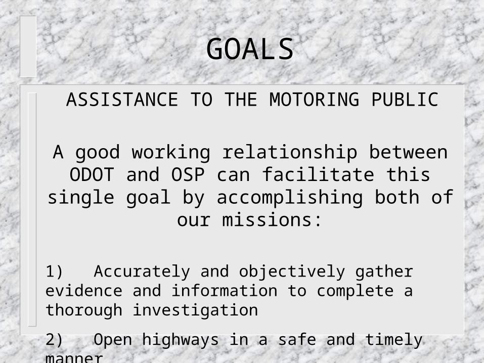
GOALS
1) Accurately and objectively gather evidence and information to complete a thorough investigation
2) Open highways in a safe and timely manner
ASSISTANCE TO THE MOTORING PUBLIC
A good working relationship between ODOT and OSP can facilitate this single goal by accomplishing
both of our missions:

OREGON LAW AND OSP POLICY
ORS 811.720 requires a report when “Any accident occurring on a highway…resulting in injury or death…”
Department of State Police Policy 601.2 states: “a crash investigation and a report will be required when….any police or governmental vehicle is involved…when an Oregon Traffic Crash Report is required under ORS 811.720”.
601.2 further states that “a scale diagram is required at all fatal motor vehicle crashes”.
Department of State Police Policy 502.14 (6) states: “Prevention of further crashes is one of the primary duties of the investigators”.
Traffic delays increase the probability of additional crashes by 600%.

ODOT MISSION STATEMENT
Annex E - Incident Management
I. PURPOSE
These procedures describe action the ODOT will take to respond to an incident on the state highway system. The procedures provide guidance and instructions for ODOT employees to enhance traffic safety and restore the movement of traffic.

ODOT MISSION STATEMENT
II MISSION
The ODOT incident response mission is to:
1. Ensure personal safety.
2. Ensure the safety of emergency responders and the travelling public
3. Take actions to:
•Ensure the highway is not blocked or restricted any longer than absolutely necessary.
•Provide information to motorists so they can make appropriate decisions...
•Protect the environment.

EMERGENCY OPERATIONS
EOP - Chapter 5 (f) EMERGENCY DUTIES:
1. Conduct debris clearance…
2. Respond to incidents that occur on state highways
3. Conduct rescue operations as directed.
4. Assist I emergency traffic control as needed.
5. Conduct emergency signing of highways as directed.

SCENE STRATEGY
So, how do we, as reconstructionists and scene supervisors, accomplish our share of these goals?
Through scene strategy:
a common sense approach to gathering evidence quickly,
yet accurately!

SOME IDEAS TO CONSIDER
1) Do not conduct any investigation on-scene that can be successfully conducted elsewhere
a) crush profiling (unless it can be done with a station)
b) lamp examination (unless evidence is transitory)
c) safety equipment examinations
d) vehicle movement recreation
e) mechanical examinations

SOME IDEAS TO CONSIDER
2) Identify that portion of the highway/roadway which offers the least restriction to vehicular travel
a) should the restriction to traffic be a vehicle, take the appropriate actions to clear that vehicle as quickly as possible:
• make the request for EMS removal of victims,funeral homes and/or tow trucks
• identify the vehicle’s position, either by hand measurements, station shoot or photography. You will likely have that vehicle identified before the tow arrives.
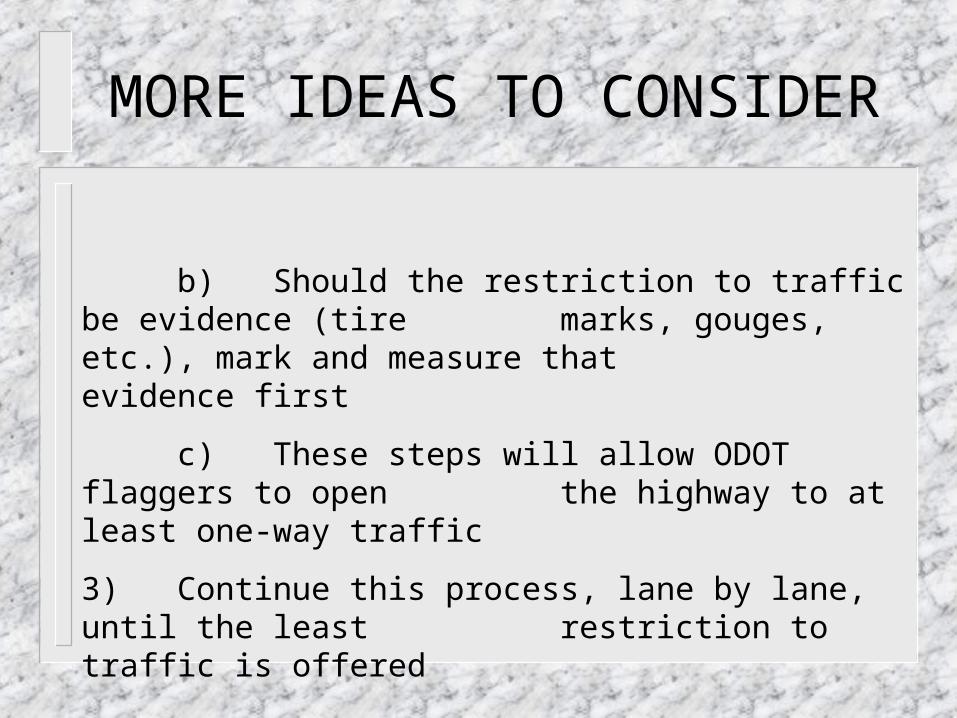
MORE IDEAS TO CONSIDER
b) Should the restriction to traffic be evidence (tire marks, gouges, etc.), mark and measure that evidence first
c) These steps will allow ODOT flaggers to open the highway to at least one-way traffic
3) Continue this process, lane by lane, until the least restriction to traffic is offered

MORE IDEAS TO CONSIDER
COMMUNICATE!
If you formulate a plan to facilitate movement of traffic, communicate that to the flaggers or the ODOT scene
supervisor!
He/she can relay that to waiting motorists
He/she will in-turn radio that information to their dispatch center, who may then enter that into the internet data base,
making it available to the public.

MORE IDEAS TO CONSIDER
Identify the least restrictive location for the station setup or the tape baseline. This will allow you to continue collecting data while traffic is moving.
Identify the least restrictive time for mapping.
Attempt to identify the most efficient clearing of highway obstructions (cars).
1) Can tows be brought in from specific areas? Wrong way down the freeway?
2) Car vehicles be towed in a specific order?

SOME EXAMPLES(where)
MP199
SHOULDER
SHOULDER
NORTH
0 25 50 100 200 25010
SCALE
4
20 17A
17
16
10DOOR 9
13A
13
9
1514
6A
6
1212A
11
7
7A8
5
TAILGATE 9
TAILGATE 9 1819
SWEAT, W.
This highway is blocked. Where would you set the station? In what order would you remove vehicles?

MORE EXAMPLES
10.0
00
2
1 0 -1
3
.1
7
3
11-1
3
.3
9
7
1 2-1 3 .3 9 6
1 3-1 0 .8 4 3
1 4 -8 .2 5 6
1 5 -5 .1 8 9
1 6 -3 .2 7 8
1 70 .7 2 7
1 8 4 .5 0 6
1 9 7 .8 0 3
2 0 11 .6 8 5
2 1 1 6 .4 3 8
2 21
7
.3
7
2
2 31
8
.5
2
6
2 41
9
.2
3
6
2 5 11 .6 3 72 61 0 .8 9 2
2 7 9 .9 4 4
2 8 8 .5 6 0
2 9 6 .8 2 8
3 0 5 .5 7 5
3 1 4 .3 3 9
3 23 .6 7 5
3 3 2 .9 3 63 4 2 .6 1 9
3 5 -1 .0 8 0
3 6 -1 .4 9 9
3 7 -2 .2 8 1
3 8-2 .4 7 6
3 9-3 .0 4 0
4 0 -3 .7 1 3
4 1 -4 .2 7 9
4 2-5 .0 6 9
4 3-5 .7 6 6
4 4 -6 .7 0 5
4 5 -7 .7 8 4
4 6 -8 .5 1 6
4 7-9
.6
8
5
4 8-9
.4
6
1
4 9-8
.7
9
5
5 0-8
.5
6
2
5 1-6
.9
6
5
5 2-6
.4
4
8
5 3-6
.2
3
8
5 4 -6 .1 6 3
5 5 -5 .0 3 4
5 6 -3 .6 6 7
5 7 -2 .5 1 6
5 8-1 .1 8 9
5 9 -2 .4 0 06 0-2 .3 9 8
6 1 -3 .3 2 4
6 2 -4 .5 8 5
6 3 -5 .9 6 4
6 4 -7 .5 5 5
6 5-0 .8 7 4
6 6 0 .3 3 1
6 71 .3 4 7
6 8 3 .9 2 9
6 94
.0
9
5
7 02
.7
8
0
7 12
.0
1
7
7 25
.2
2
8
7 34
.8
3
4
7 45
.3
3
6
7 55
.7
3
7
7 6 5 .4 4 47 7 5 .2 6 7
7 8 4 .9 2 3
7 9 4 .5 1 2
8 02 .5 5 6
8 1 3 .0 9 1
8 23 .7 2 1
8 3 4 .2 5 5
8 4 4 .6 6 5
8 5 5 .1 5 68 6 5 .3 5 1
8 7 5 .0 4 3
8 84 .4 8 5
8 93 .8 5 0
9 0 3 .0 6 6
9 1 2 .6 1 2
9 2 2 .1 9 2
9 3 4 .9 9 5
9 4 5 .0 1 8
9 5 4 .9 3 5
9 6 4 .7 3 0
9 74 .4 6 9
9 811 .3 8 0
9 9 9 .6 5 0
1 0 07 .7 0 0
1 0 16 .0 7 7
1 0 25 .1 0 6
1 0 33 .6 0 1
1 0 40 .6 4 3
1 0 5-0 .3 3 8
1 0 6-3 .0 9 5
1 0 7-4 .7 7 3
1 0 8-5 .2 8 1
1 0 9-5 .9 2 8
11 0 -6 .5 4 5
111 -6 .0 5 4
11 2 -4 .6 0 7
11 3 -3 .2 5 0
11 4-1 .7 9 4
11 5 -0 .6 1 8
11 60 .3 7 9
11 7-5.5
57
Tip-over tire mark
Pavement edge
Fogline
Steel guardrail
Fogline
Damaged guardrail position
Original guardrail position
Scrape marks (unit #1A)
Gouge mark (unit #1A)
Tire mark (LF, unit #1)
Gouge mark (LF wheel, unit #1)
Unit #1
Unit #2
Slope = -5.4%
Super elevation = 11%
FATAL MOTOR VEHICLE CRASH09-09-00 5:50 PMHIGHWAY 26, MP 108.5, JEFFERSON CO.DRIVER #1: GILL, CHAMKAURDRIVER #2: TURNER, COLLEEN (DECEASED)CASE: 00392973
0 25' 100' 250'
Scale
Unit #1A
Load scattered
Where do you set up?
What do you document first?

WHEN?
x
Cimaron Motel(south)
Union 76gas Jiffy
Lube
Chans
Post Collision Situation MapN
Albertson(central)
(south)
SurplusStore
Cascade Lodge
0'25' 100' 200' 300'
400'
scale
P.Waters(flagger) (flagger) (flagger)
D. Goncescuffmarks
shoe
(two)
Victim NYE
with stop sign with stop sign with stop sign
J. Mcdonald(flagger)
legend
= construction overhead lights
= traffic control cones
Bend Cinema
E.Caldwell
rest.
and carwash
3rd St., Bend. 300’ short of 1 mile. When would you attempt this shoot?